
Leilani estate fissure
Update May 8

Source: USGS
No major changes. The lava pond in Kilauea is now reported as 220 meters down, and may still be dropping. The most recent images suggest it is still going down. Below 400 meters there would be a risk of ground water getting into the hole with phreatic consequences, but so far there is no indication things will get that far. The tilt i still changing, at a uniform 20 microradians per day (as pointed out in the comments, that is 20 millimeters change over a 1-km length. In practice, the length over which the change happens is not known from a single measurement.) Assuming a circular area of radius 1km, this means a magma outflow of 50,000 cubic meters per day. The tilt in the eastern rift area is beginning to stabilise. A better number come from the GPS which has shown a downward movement of just over 10 cm so far of which half was just in the last day.
Pu’u’o’o is little more than a hill with a big hole. There is no lava left in it; it has all been drained into the eastern rift. Almost nothing has made it to the surface: most is in the dike.
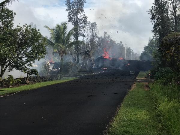
Leilani survives although over 30 houses have been lost. The pattern is repeating where a fissure opens, sulphurous gas comes out followed by sputter, thick lava begins to creep by after a few hours the fissure stops and the lava grinds to a halt. The most recent fissures are on the west side, beginning to extend beyond Leilani itself. PGcam is now a bit far from the action. Cracks in highway 130 suggests that area is at risk now: activity may be shifting west a bit although that is not a promise! The highway is reportedly closed in this location. The sequence and lack of real lava suggests that the fissures are caused by degassing of underground magma. The gas comes up, collects just below the surface and forces a fissure to open. A bit of lava follows but the gas is coming up much faster than the magma. The longer it takes, the more it becomes that the magma will stay down, at least in this location. However, if a larger conduit opens up things could worsen rapidly.
Seismographs remain noisy around Leilani but are rather quiet around Kilauea. Mauna Loa is also keeping its head down.
Update May 6
New fissures are continuing to open, as the previous ones die down. What would normally happen is that one long fissure opens, before after a day or two reducing to a single point of eruption. Here the rift opened but there wasn’t enough pressure underneath so it alternates between different parts. The fountaining has increased to 70 meters, so there is now more oomph, but the eruption has not yet settled down. There is a risk of a fissure opening up in highway 130 (cracks are reported there) whihch would cut off one of two escape routes from the coast.

Update May 5
Over the past day there have been interesting developments. The fissures have continued. There have been 6 reported centres of activity, including one just to the east of Leilani. The fissures behave similarly: a crack develops due to movement at the surface, gas comes out, and sometime later bits of lava are ejected at some speed. The burning fragments go some tens of meters high at most. No effusive lava appears and the ejecta stay within a few meters of the fissure. A video of the third fissure, courtesy of the USGS, is here. The first five fissures have all ceased activity.

The limited amount of lava suggests that the main magma dike below has not been breached. Only a little magma has been forced up underneath Leilani so far.
The earthquake activity has been worldwide news. The inflation has triggered movement on a fault running underneath the south coast, first pushing the upper crust out, followed by some sliding outward on the other side of the fault. The M6/9 is not huge to Hawaii standards but it is the largest earthquake to hit the US this century outside of Alaska. The large change in tilt at Kilauea following the quake suggest a vertical movement of 0.5 meter. (HVO has now reported that GPS measurements gave 0.5 meter of slip along the flanks of Kilauea, so that agrees pretty well with our number.)

The image above shows the location of the fault. Here the earthquake is plotted at its first reported depth. Later analysis moved it up to around 6km depth, putting it on the Hilina fault. It is part of the normal movement along this fault, which tends to occur in earthquakes of M7 or so. The last one was in 1975 and it is plausible this earthquake was due to happen soon already (stress was ready and waiting) and the earlier M5.7 pushed the stress over the limit where static friction could not hold things together. The eruption was thew trigger but not the cause.

Earthquakes over the past 24 hours, courtesy of BillG
What happens next? So far every day has been surprise! The most likely surprise for today is that nothing happens. The eruption now has to wait for more pressure to build up before the magma breaks through more forcefully, and perhaps not quite in the same place as before. But lots of other things could happen. HVO is expected that more fissure vents will open around Leilani because inflation in the area is still continuing. It is also worth keeping an eye on the coast southwest of Kilauea, where the Hilina fault has also moved and a swarm of quakes followed near the surface. This lies near the location where HVO has stated Kilauea’s magma supply may be located, with regular deep earthquakes. The area was utterly silent before the M6.9 but has come to life since.
Keep posted, and keep sending us you info!

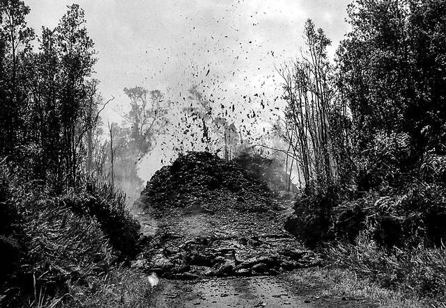
Source: USGS. A photo taken after fissure 5 (in the foreground) opened.
May 4: the Puna eruption.
The expected eruption came some time after a M5 earthquake. It started with deformation and cracks appearing in the Leilani estate area.

The east rift zone extends from Pu’u’O’o to the coast and in fact there are some cones just off the coast, safely under water. The earthquake activity occured in clusters along the entire rift. There were also earthquakes off the coast. It was unclear where the magma would reach the surface. The rift stopped extending and little happened for about a day. However, once cracks appeared in the road surfaces, it was clear a weakness had been found.
At first the cracks were only on the surface and there was no evidence for heat or gas emission. However, after a while SO2 began to rise and in the afternoon of May 3, lava erupted from a 150-m long fissure. It was energetic but not voluminous, and the eruption ceased after 2 hours with lave within 10 meters of the fissure. Three further fissure events nearby followed. In all four cases, fountaining reached 30 meters high but the lava did not really begin to flow.
The first fissure was close to a geothermal pant. This might be seen as an energy bounty, or one may wonder whether the drill will provide a magma conduit!


The first three fissures are shown in the map. The fourth one was reported to between the first and third fissure. The four events are aligned with each other. A fifth one may have opened near the geothermal plant. It appears that the pressure was insufficient for the entire rift to open at once, and only parts are becoming active, perhaps slowly merging into a full fissure. The amounts are small and the pressure behind the eruption seems limited. However, the events are within an inhabited area and damage to property seems a certainty. Two houses (or structures) are reported to have been destroyed.
It is not known how the events will develop. This may fizzle out, or it may be the initial stirrings before the main magma flow reaches for the surface. The major deflation at Kilauea has started, but the magma from there will not yet have reached the site of the current eruption. It it does, a more significant eruption could be triggered. It is also possible this will cease, and a new fissure will open west of highway 130. If the current fissure develops, a number of houses at Leilani are at immediate risk. Further downhill towards the sea is a fairly empty area with few dwellings.
There was some discussion on the risk of a flank collapse. That chance is near-zero. The flanks have shown slow-slip events but these are normal part of the settling of Mauna Loa. Nothing at the moment points at an instability, and neither would one expect that an eruption triggers a collapse: a major earthquake s more likely to do this but the flank has survived M7+ earthquakes in historical times so it seems stable. No worries.
An M5.7 quake hit in the same area as the previous M5 events, followed by after shocks. these are between PU’u’O’o and the coast and likely caused by the pressure loss of the magma chamber.

KLUD seismograph, near the M5.7 quake.

The map shows the location of the earthquakes (as of yesterday) on the deflation map. The M5+quakes are south of Pu’u’O’o, in the area of deformation that runs along the coast. Most of the earthquakes are along the upper line of the deformation.
Pu’u’O’o has lost its entire 20 centimeters of extension in the most recent GPS data, and the eruption there has ended. The chances are that it will restart in the next weeks or months. However, could this herald the end of the 30+years of near-continuous eruption? The larger the Leilani eruption, the bigger the risk to Pu’u’O’o.


Good video of the fissure. Quite alarming to have that in the suburbs.
[youtube https://www.youtube.com/watch?v=eNa3Vkj1KkI&w=560&h=315%5D
Cheezy audio. Sounds like it should be a Braveheart video.
I watched it on mute, so didn’t notice.
I don’t typically mute just in case there is something worthwhile to hear. I also never put audio in my plot videos since my taste in “music” may not fit with what people like to hear.
and i hate ‘music’ in nature videos because i’m pretty sure there is no orchrestra on the edge. Love good music but like realistic sounds to wildlife vids. Nothing more jaring to see some terrific natural video and turning sound on to hear music. any music… Natural sounds are sometimes
Best!motsfo
And to note, the end of the old flow at Pu’u O’o marks the conclusion of the 7 year long Episode 61 of the eruption. What an introduction this is to Episode 62! The necessity of fleeing the area is so apparent that even HVO aren’t bothering with mentioning the raising of the alert level to Warning this time round!
M6.2 now!
https://www.emsc-csem.org/Earthquake/earthquake.php?id=663591
That’s the 5.4 as reported by the USGS.
Now on USGS 6.9!
https://earthquake.usgs.gov/earthquakes/eventpage/us1000dyad#executive
I got the wrong quake anyway, the 5.4 was exactly one hour before this. Bloody hell almost a 7! Has an earthquake of this size ever been recorded related to eruptive activity before?
Thrust fault again… 11.5 km deep Ideas?
https://earthquake.usgs.gov/earthquakes/eventpage/us1000dyad#moment-tensor
From USGS:
“The May 4, 2018, Mw 6.9 earthquake in Hawai’i occurred as a result of reverse faulting on the south flank of Kilauea volcano, in the east rift zone. Preliminary focal mechanism solutions indicate rupture occurred on shallow dipping thrust fault striking southwest, or on a steeply dipping reverse fault striking southeast. This earthquake is directly associated with volcanic activity at Kilauea volcano, and the evolution of its rift system and volcanic edifice.”
Source: https://earthquake.usgs.gov/earthquakes/eventpage/us1000dyad#executive
Depth seems to be 5km. Kilauea lies on ocean crust.
That’s still in the toe region for the ongoing slump. It may take a few thousand years to complete though.
Just to confirm the best place to get photos from HVO’s field crew: https://volcanoes.usgs.gov/volcanoes/kilauea/kilauea_multimedia_15.html
I go to bed for 8 hours and I wake up to there being 2 new fissures and at least 1 magnitude 5 earthquake. I am honestly surprised there apparently haven’t been any lava flows at all yet, maybe this is what a lot of eruptions start like and the historical difficulty in getting there more than a few hours later is why this looks small. As noted before the deflation from the summit hasn’t gotten to the active vents yet.
It is quite plausible that the 1955 eruption started with the same mechanism as this one, the original intrusion starting around the point where the east rift curves (where mauna ulu is now) and triggering an eruption of 1924 magma, and the eruptions were not particularly big or extensive until the summit started deflating significantly and more magma was involved. It took 8 days in 1955 and appears to only be taking 3 now, but the rift is much more open now than it was in 1955 so this makes sense.
There is a crack in the pohoiki road too, which is downrift of where the current activity is, so there could be an eruption further down the rift later on.
Can someone please tell me some of these are not real!
All real! This is the 6.9 and you can hear the reaction:
https://mobile.twitter.com/HawaiiNewsNow/status/992537771305652224
This 6.9 is Hawaii’s largest quake since the 7.4 in 1975!
Yep… and the ’75 quake accompanied a land slip. Unfortunately, the 6.9 is roughly in the vicinity of the Hilina scarp face at 11.5 km depth and shows thrust faulting… characteristic of what you would expect there as the toe of the slump slid a bit. A 6.9 reverse mode fault has an average displacement of 0.65 meters on the fault face.
Pacific Tsunami Warning Center says this;
THIS EARTHQUAKE GENERATED SMALL SEA LEVEL CHANGES ATSOME LOCATIONS ON THE BIG ISLAND. MEASUREMENTS INCLUDE
HILO 20 CM AMPLITUDE
KAPOHO 40 CM AMPLITUDE
HONUAPO 15 CM AMPLITUDE
AT ALL LOCATIONS THE FLUCTUATIONS ARE NOW DIMINISHING.
https://ptwc.weather.gov/text.php?id=hawaii.TIBHWX.2018.05.04.2327
Note that this is a compressional event, either reverse or thrust. Several of the M5 quakes in the same region were also compressional. This is not the type of event that would normally be expected on the Hilina fault system given that it is a gravity driven circular slump. Perhaps there’s a swelling chamber of magma under the Puna geothermal field below the depth of the hypocenter of the earthquake that pushed the seaward side of the fault upwards. The other option is a shallow mass of lava on the landward side of the Hilina fault system. The second option doesn’t appear to be as consistent with the seismicity pattern.
Generally rift systems have extensional faulting events. I was anticipating that this would be a normal faulting event, not a reverse faulting event. The fault motion is in the opposite direction of a gravity slump event.
Held by our spam daemon for approval. Hereby released – Admin
Article on the 75 quake and in the abstract it mentions that this will help “stabilize Kilauea and make catastrophic failure of the volcano flank less likely at this time.””
“……To do this, we present a new structural interpretation of geological data from Kilauea, along with modeling of the tsunami using recent seismic analyses. In so doing, we hypothesize an offshore north-facing normal fault that we call the Kalapana fault, because of its limited onshore expression near Kalapana. We argue that several different interpretations of seismic data are simultaneously true, each coinciding with a specific geological structure. We perform a direct numerical simulation of the 1975 Kalapana tsunami, and we report results for the near field and the far field simultaneously. Our interpretation of geological structures provides sufficient constraints to derive three tsunami sources: the Kalapana fault, a slump, and a thrust fault. These three tsunami sources are mechanically coupled according to our model of Kilauea evolution, although their contributions to tsunami generation remain relatively distinct. Slump displacement predicts a small shear stress beneath Kilauea volcano. We find that our geological interpretation and tsunami sources are sufficiently robust to reproduce almost all tsunami observations. Repeated earthquakes like the 1975 Kalapana event will produce extension and subsidence in the upper flank of Kilauea, as well as compression and uplift of the toe region, accompanied by limited slump movement. These deformations appear to stabilize Kilauea and make catastrophic failure of the volcano flank less likely at this time.”
https://www.sciencedirect.com/science/article/pii/S0025322704003251
You know, Guys, i’ve been hitting all the info all over the net and STILL the best clearing house for all of it is right here…. You People are terrific… Best!motsfo
I wholeheartedly agree with this sentiment. This is a really special community here.
Held for approval by our spam deamon. Future comments should appear without delay – admin
I think we need to donate some money to the HVO so they can add some more band with to their site. I am having a hard time looking at anything. Called my brother in law who is a seismologist and one of his co workers spent a lot of time at the HVO so we will see what they can add.
It’s not just HVO. That news site that everyone keeps linking to goes into massive lag spurts also. It makes me think that HQs server is also in Hawaii from the similar lag pattern.
and it is possible to crash volcano info sites… i think it happened at Meripa…. sometimes it’s best to leave the main lines for the locals…. You Know, motsfo
Sure, they are probably counting marks… but symbolic thought is symbolic thought.
https://www.livescience.com/62484-neanderthals-scratched-messages.html
For those who can’t easily get USGS data, that 6.9 caused a bit of a phase change in the eruption:
Five fissures now (after the 6.9)
http://www.hawaiinewsnow.com/story/38087728/puna-warned-series-of-quakes-could-indicate-eruption-is-possible
Very disturbing. Was this area populated 50 years ago?
It was not really populated in 1955. The forests and cropland back then are now backyards. It was only a matter of time, but that doesn’t make it any better if its your house. 🙁
This area has been lightly populated for hundreds of years. Hawaiians have known that the southern 2/3 of the big island is subject to change without notice since long before Captain Cook landed on the south Kona coast. The soil is excellent for growing papayas and land is cheap because who knows when the next eruption will come? It’s a poor man’s paradise when there’s no hot lava.
Ugh thank god I’m back here, just been in a live stream of the news coverage. Turns out the stream is part of the cult of dutch (you know who). Got kicked out when pointing out the truth lol. Sheep!
I havent watched a video of dutch since the time he tried to say that pangea is a hoax and that america is being pushed east by the pacific plate, with the mid atlantic ridge being a fold mountain range….. I mean we have pretty solid proof against that now… Flat earthers in disguise basically.
Buahaha!
looking at the pg cam, it looks like the rift has extended to the left, east/north east from the original rift near the blue roof water storage unit.
I saw that too, there is probably a new fissure near the geothermal plant, and downrift of the first ones. This is near the fissure over pohoiki road.
I figured out where the PG cam is, it is on a cinder cone just above the geothermal plant.
I remember there being an old site that included a pretty detailed overview of the east rift, and it gave a name to this cinder cone but I dont remember exactly which one it was. It might be halekamahina, but that might be a bit further downrift near kapoho.
In light of its physical size and the duration and volume of its eruption (which still might not be over), pu’u o’o should get renamed to pu’u nui (which I think would translate to ‘big hill’). It might even be more appropriate to call it mauna nui.
I dont think you can rename the vents once they are named though, so maybe any significant vent structure formed from these new eruptions could be given one of those names instead. Pu’u nui is a pretty awesome name though.
Theres only been 4 eruptions in lower puna in recorded history, including this one, so this isnt a common event and is likely to leave a big mark on the area before it stops. The main eruptions of 1955 started some weeks after the eruption began, and more started about a month later, so what we are seeing now might only be the initial stages of what will become a much more substantial eruption later on.
For anyone that was watching the Hawaiian event on MultiView Volcano Live, VolcanoYT put Kilauea on stream by itself.
I have to admit, the travis.sanders.35 (fb) Live feed is captivating. He’s tromping around in Leilani Estates shooting video of the scoria being flung into the air. VolcanoYT is showing it in conjunction with local news.
thanks 🙂
Neat aerial footage of fissures.
They are reporting a 6th fissure has opened up at the Leilani Estates.
😀 Duh I hadn’t looked at my post yet. Didn’t see it right on front of it when I put it on here. 😀 😀
This is a detailed report of the 1955 eruption, written by the head scientists of HVO at the time.
https://pubs.usgs.gov/bul/1171/report.pdf
It appears that the 1955 eruption was a bit more intense than what we have seen so far, but not all eruptions are the same.
It is also notable that there was a pause of 3 weeks in the middle of the eruption, before resumption of activity at a high rate.
There is also a bit of information on a possible eruption far down the hotspot chain beyond kauai, which is interesting.
http://www.bigislandvideonews.com/2018/05/04/video-latest-volcano-eruptions-on-hawaii-described-by-scientist/
Pu’u nui is growing…
Heh… he confirmed that they did reposition the camera to look at the Leilani estates.
Yes, and I finally figured out where it is too, it is on the side of pu’u honuaula, a cinder cone a bit less than 400 years old, formed in about 1650.
It shows what eruptions in that area can do, so this new activity is nowhere near what it could become. Given the situation now I would not be optimistic about the survival of leilani estates…
What was once a small town might be a 100 meter tall hill of spongy gravel in a month.
According to the drainage maps any lava flows from these existing vents will mostly go north and then east towards kapoho. If vents open further downrift then they will be similar to the first set of 1955 vents. Vents further uprift will flow directly south to the sea, like the second part of the 1955 eruption, which was much bigger than the first.
Did the fissures stop erupting or is there fog over the webcam?
The lights in the middle of the screen are gone to, but they were on the geothermal plant which got shut down so I dont know if that means the lights turn off.
Last I heard about the plant was it was okay, for now. Yesterday they cleared it of flammable as they were shutting it down. I would imagine that means lights out, but ya never know. Vog was noted as a hazard, but the news kept cutting off the weather guy as he was still talking away, so I don’t know the forecast.
i read that a lot of people lost power after the 6.9 but forgot to note where i read it…. sorry…
A 6.9 is good enough to sling a transformer off of a pole, so that’s not surprising.
It was apparently most of kilauea up to Hilo, though I think nearly everywhere has been restored by now.
Thanks and it’s 1am here… and did You ever say why Your handle is turtlebirdman? i’m motsfo cause grandkids started calling me that more than20 years ago…. have no idea where they came up with it…
Of course if a transformer fell off a pole etc, that’s an issue.
Power outages from quakes more typically may be from transformers in larger substations on the ground. They’re oil-cooled and have automatic shutdown to protect in case the oil level was to drop. The oil sloshes around in a quake triggering the low oil level sensors – the power is shut off, and apparently they may need to be manually checked before being reset.
well that makes sense… Thanks….
and checking the seismic in HVO they’ve had over 4000 earthquakes now… crazy… probably most of those weren’t felt.
The M6.9 caused havoc at Kilauea. The tilt shows a large jump. The quake was 20 km from here, and the tilt jump by 25 microrad, so that makes a vertical slump by the quake of 0.5 meters.
A quake this size could significantly change the plumbing of the eruptions.
In the mean time, an M5 quake on the coast in the southwest rift zone (opposite side if Klilauea!) has gone unnoticed. There is a lot of shallow shaking there. It was completely silent before the M6.9
Oraefajokull alert lowered back to green yesterday.
The things jon is predicting on the iceland geologi blog about øa in iceland is badass. Imo have downgraded øa. He saying its a bad move
Thanks for spotting it in all the Hawaii noise. I read his comments, looked at his diagrams and followed up the article he refers to. I totally respect Jon’s skills and I have a gut feeling he’s spot on. It will be worth watching Öræfajökull closely.
One thing I actually am really fascinated by is when vents open over roads, it just doesn’t seem like a logical thing, even though it would be unlikely not to happen given where the eruptions are happening.
From 1955:
From about 8 hours ago:
I actually have a favourite book that I read, and the picture I was most interested in was the same as the one above of a spatter cone over a road in 1955. I actually never thought I would see an eruption like that in my lifetime.
My previous idea was that pu’u o’o would eventually slow to a stop and any extra eruptions would be like in 2011 uprift of pu’u o’o. The overlook crater would fill and overflow the summit caldera, like what happened from 900-600 years ago, and continue the slow continuous eruptions that have been happening since 1986, just from a different location. Even only one week ago I had quite good reason to follow this idea when the overlook crater overflowed repeatedly.
Well look where we are now…
Here is a view of where it’s eruptions atm.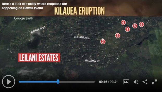
Looking at the lie of the land in Leilani Estates on Google Earth, it appears the fall to the East is about 20 metres per kilometre and fall to the north is about 17 metres per kilometre; so the flow from any of those vents should head slightly east of north east, if they get moving at any rate.
All the vents except 6 are in a drainage that would go north towards the northeast coast, similar to the 1840 lava flow. Vent 6 is on a flat area where it could equally flow south towards the ocean or towards the other vents and therefor north.
I think all of the fissures might have stopped now though, there is no glow on the webcam, although the area might be fogged over so nothing is visible. Is it known if the geothermal plant turned its lights off because you can see the lights in the center of the webcam most of the time and those are gone. if the lights are turned off then the area is probably actually dark, but if they are turned on then there is fog and the fissures might still be erupting behind it. I’m sure there will be information soon, it is only about an hour until daylight in Hilo.
My guess is that the fissures might be mostly stopped but one or two vents are possibly still going at a low level constructing spatter cones, and that there probably wont be much lava outside the vent areas. More vents will very likely open over the next few days though, I think if an eruption is going to happen in this area it will be either fast and furious (1960, 1840) or slow, episodic and very drawn out (1955, 1790, 2018 so far), both ultimately being quite big eruptions. 1955 had hiatus periods of up to 3 weeks between eruptions so it will be hard to tell when things stop, added with the fact that fissures seem to open with little warning, though often after larger earthquakes.
The presence of an open dyke into lower puna also greatly increases the risk of repeated eruptions in the area in the years to come, much like how the 1955 dyke allowed magma to erupt there again in 1960. The magma supply rate to kilauea is at a high point in a long cycle, so it is extremely unlikely that this activity will result in a long hiatus in eruptions like in 1934. The show started 36 years ago but the main events are maybe still in the future.
USGS summary of activity to date. Very informative video (confirmation of 6 eruptive fissures etc). https://www.youtube.com/watch?v=cY5-nJ1tpdo
She does a good job of saying this is only the beginning without causing a mad riot of panic. Looking at the map of Leilani Estates that Albert posted below, it might be tempting to hope that since activity is moving eastward, the folks on the west side are in the clear. Then you remember that the lava traveled beneath them and they are on the reservoir side of the flow. Makes me feel lucky that we only have to deal with terrorists, snipers, and anthrax mailers in this region. I far enough inland that a Canary Island collapse will just take an hour or two off the drive to the beach. Makes you remember that civilization is fragile, creation destructive, and we survive as a species not as individuals.
Looking for the seismogram on KLUD, most eq´s starts with P Wave upwards, while some starts the P Wave downwards (like the 6.9).. different focal mechanisms? Different sources (tectonic, volcanic)?
The downwads P wave Eq´s tend to be more low frequency (2~5Hz), but also occurs in higher frequency (10~15Hz).
Regarding volcanic tremor, besides yesterday which had a peak of volcanic tremor around 12h/13h (UTC), volcanic tremor is present, but in much smaller amplitude..
Those 1st motions just tell you if the equipment is in a compressive or tension quadrant for the quake. Compared to the same quake on other seismos is when it can give you focal mech data.
I can’t help you with the frequency data… but in general, the lower frequencies are associated with larger masses of fracturing rock. (Larger fault faces)
Is the main magmachamber of Kilauea overpressurised now and is Kilauea able to erupt 10 km³ of lava in a few days? A VEI6 eruption, but effusive.
Pu’u o’o is about 4 km3 total, and technically it might not be dead so it could be more at some point, so I think kilauea has already done something pretty exceptional.
10 km3 of lava is something that requires a big chamber or an extremely active rifting plate boundary. In theory kilauea could maybe do 1 km3 at most in one go if an existing dyke is open to low elevation but such a situation has existed several times in recorded history and no flank eruption in at least 500 years has been anywhere near that big and fast, suggesting such an eruption is not possible or at least very unlikely.
The summit magma chamber contains maybe 2 km3 of magma at maximum, but not 10 km3. To get an effusive eruption that big you need to go to Iceland or maybe some parts of east Africa where the crust is thicker. To put into context, holuhraun was 1/3 the size of pu’u o’o in 1/72 of the duration…
Kilauea is a very powerful volcano as far as individual systems go, it probably has one of the highest magma supply rates of any single volcano, but it pales in comparison to the ice giants of the north. You wont get anything above VEI 4 in Hawaii, and you wont get a VEI 4 without a deep caldera and magma water interaction either (1790 explosion). This cant happen now as the caldera is much too shallow.
I also doubt that 10 km3 of magma of any composition would be able to erupt effusively, the eruption rates would be enormous and probably enough to blow apart even the most fluid magma. 10 km3 is more than half of laki in 3 days. Laki took 8 months and some of those lava fountains were 1.5 km tall and bordering on subplinian eruptions.
To put it more directly, no. Kilauea isnt going to go flood basalt+krakatoa…
And does Kilauea have some magma pockets with much more evolved magma like dacite and rhyolite? When molten basalt enters these pockets a violent explosive eruption will occur.
The initial drilling of the puna geothermal well (the one that is near this current eruption) included drilling into molten dacite at 2.5 km deep, but it was apparently fluid enough to move up the drill bit a few meters. This alone shows it isnt like regular dacite which would probably have behaved almost as a solid in that situation. The deeper part of the east rift is probably filled with more silicic magma pockets that are continually heated by frequent eruptions without erupting.
The other reason this is very probably not going to be causing a violent eruption is the simple fact that this exact magma has likely been intruded by the new magma in the last week and nothing has happened… In all honesty if what you are proposing was something that could happen then every hawaiian volcano would erupt in a violent plinian fashion in every eruption. The only silicic magma on the big island is trachyte on hualalai that formed because of its transition to post-shield building. Kilauea is probably not even at the peak of its shield stage yet. mauna loa might erupt some trachyte in about 50,000 years or something but that is a moot point now.
Kilauea isnt doing anything big and explosive in this eruption, it is not the sort of volcano to expect these eruptions from either. Kilauea has violent explosive eruptions when it has a deep caldera which allows groundwater into the bottom to form a crater lake. The last one happened in 1790 and that eruption seems to have ended this phase of activity because the entire caldera was half filled with lava 30 years later. There is no deep caldera now so there will be no VEI4+ explosions either. The eruption in lower puna might have magma water interaction near kapoho crater if it actually erupts there but that isn’t going to be huge.
Basically this eruption is a big change from previous activity but nothing unusual in the long term.
I understand that Timanfaya fisural eruption in the Canary Islands produced between 3 and 5 cubic km of lava in six years. Might that be related to some kind of rifting afecting the eastern islands (Fuerteventura Lanzarote and maybe Gran Canaria) that could explain such a big volume of lava?
Held for approval by our spam deamon. Future comments should appear without delay – admin
Yes I think you are right, there is a post on that eruption on this site somewhere, it was a big eruption. But it wasn’t 10 km3 in 3 days, which was the idea in the comment before. I dont think even the Deccan traps eruptions that sent lava flowing over 1000 km away (no you didn’t read it wrong) had that sort of eruption rate…
That sort of rate can probably only happen in pyroclastic eruptions due to the viscosity of silicate magma, even very hot fluid basalt would be pulverized at a rate of 3 km3 a day… Tarawera in New Zealand in 1886 is basically proof of this.
Past 24h quakes with fault lines on map. I think a new interferogram would be important.
I think Sentinel 1B will pass on Hawaii today, satellite products from Sentinel 1B come 3 days after Sentinel 1A. Last Sentinel 1A pass was on 2018-05-02, so Sentinel 1B should pass today (16:15h UTC). If not, Sentinel S1A will only pass on 2018-05-10 (?).
A brief update has been added at the top of the post.
I dont think an eruption on the southwest rift is going to happen soon, the summit is draining out towards puna quite fast now (see below comment) and I dont think there will be enough pressure to force a dyke into the southwest rift. There is apparently significant magma stored at the point where the southwest rift and koae fault intersect (called the kamakaia hills) and maybe some of this could be squeezed out in a quake. Given that in 1974 an intrusion actually reached this area though and then a very big quake happened within a year of that and did nothing, I wouldnt count on it though. In the years to come it could happen though, there were a few eruptions in the kamakaia hills during the 1700s and apparently one in the early 19th century some time before the 1823 eruption. The last 36 years at kilauea has been exceptional, and the next 36 might be too, unless you live in lower puna and your ‘cheap’ $500,000 land gets (re)claimed by Pele.
(why is everything so expensive in Hawaii? I know its an island but I live on an island too and its not inner city prices here… Is everyone actually millionaire in Hawaii and disguised by the expensive lifestyle?…)
Not from Kilauea. But the earthquake cluster is intriguing and in theory this is a region that could source its own magma. The current activity is tectonic.
I dont think the southwest rift is a deep feature, apparently the magma from mauna iki in 1919 was sourced from less than 1 km deep under halemaumau. Same with the 1823 eruption. Both rift zones are entirely in the volcano and are not equivalent to plate boundaries with mantle connection under the whole thing. The earthquakes under this area at depth show magma moving up, but I have read a paper that shows earthquakes before the 1959 eruption were from north of kilauea, so maybe only the recent activity since 1982 is being fed from that area. The magma feed for kilauea probably extends as a circle around the caldera that probably significantly overlaps with the feed for mauna loa, which would explain why they alternate in activity with each other. The high rate of eruption at kilauea now might also mean mauna loa is going to stay largely quiet for a while longer too (it will probably erupt within 10 years anyway but might be another 20+ years before it erupts again after that).
https://pubs.usgs.gov/pp/1806/pdf/pp1806_report.pdf
What I mean with the 1950s quakes is in this pdf.
Kilauea is probably the volcano I know the most about (as im sure I have made obvious by now 😉 ), mainly because I have been almost obsessively reading basically every update put out by HVO since the start of 2011, and saw a video of lava in the kalapana area in 2010 and knew I wanted to see that in real life.
I was but a wee lad of 12 years back then…
It is very expensive based on land speculation, not necessarily due to *house* speculation. A lot of the houses in Royal Gardens were absolute dumps–no sewer, water or electricity. Let’s call it an ‘alternative lifestyle’. I stopped at a convenience store in Mountain View–every car on the lot was a junk pickup truck. Every truck had a pitbull in the bed. Every driver had three teeth.
All that said, the houses I’m seeing in Leilani are very nice. Doesn’t matter who you are or what your house is like, to lose your home is heartbreaking.
Halemaumau has drained down a lot now. It has exposed a lava bench active in late 2011 when the lake was 70 meters deep. That bench got submerged when the lake got higher in 2012 and I think that up until last week the lake was above 40 meters deep for 95% of the time since then. My guess is that it will drain entirely in this activity though, and possibly collapse somewhat and become wider and more shallow. Eruptions will probably resume in the overlook crater within this year though either way.
Pu’u o’o might have eruptions in its deep crater, but I dont think anything will be flowing there for a while. It might well be functionally extinct now and any eruption from now on will be because it is directly on the dyke to lower puna and could be a pressure release. The magma erupting in leilani is quite gas-rich as evident by the almost strombolian nature of the eruptions, so it would be interesting if any future activity in pu’u o’o might be similar. It also might be interesting whether to consider the activity in puna to be a new eruption or a continuation of the 1983 eruption, or whether the overlook crater is part of the 1983 eruption too. At least the overlook crater seems to be likely to outlast pu’u o’o, and might become the central vent for a significant part of the future, so if the overlook vent still exists in 100 years time, would that mean kilauea had been erupting continuously for 150 years?
The lack of visible activity in the night was indeed because of fog, because there is still an active fissure on the webcam a little bit to the right of the previous ones, as well as the remnants of the fog. I dont know if this is new or from yesterday but the eruption is still going.
So if you remove the water from the ocean, this is how it would look off the shore of the eastern rift zone. from Google Earth. Seems like with the gravity pull and magma push one wonders if Loihi is too far west to block movement. Obviously the mass of the water is important.
In the last thread Geo Lurker and I started a conversation on potential flank failure which I am continuing here —
Geo Lurker wrote,
Interesting thing to concider. Maui Nui was 40% larger than the island of Hawaii before the Nuʻuanu Slide event. Everything I’ve seen on the matter points to it occurring after the active volcanism had drifted to another location in the chain.
Perhaps the lack of active and persistent suturing allowed the edifice to weaken and eventually fail? Volcanic gases persist for a long time after eruptions cease. SO2 with water yields H2SO4, and over time, solid rock is altered yielding clay and clay like material.
___
^I suspect this is indeed correct. And this is why the Hilina Slump is not actually the main threat. The Hilina Slump is what’s currently building mass for the island.
The lack of persistent suturing on the *other* side of Mauna Loa is what is most likely to result in a collapse, IMO. It is like building a sand castle and mounting new sand on one side. Eventually, another portion will become unstable and drop off (it usually isn’t what you are actively building).
The geography of Hawaii’s Western Coast is particularly interesting for how Mauna Loa’s SW flank sticks out after Hualalei. I would think the added mass of Kilauea’s ongoing eruptions and general activity on the SE flank would actually result in a collapse on the western flank of the island. The build-up of volcanic activity on the eastern side would likely be prolonged and continuous, while the flank failure on the western side would happen within the span of minutes.
I would also argue that the coastal topography immediately to the NW of Mauna Loa’s flank portends it should not be there for much longer.
See image at link:
https://ibb.co/kBr517
…and also see:
Cool discussion. Nice to know the volcano is settling rather than collapsing. I could imagine the magma intrusion like a hot knife slicing through butter to calve off a slab of the flank. It’s good to remember that the weight of the flank and the ocean is pushing against that possibility. Of course, the pressure is also pushing the melt out in fountains. Geophysics. Fascinating.
The eruption is reported to be intensifying. not clear which fissure but probably number 6 on the map
today

yesterday

I keep hearing about a 7th bigger fissure.
Atleast the activity seems to slowly move out of town, judging on that map
Note the blue streaam indicated on this map. They should give the direction that the lava would take if the eruption goes larger. It seems Leilani is right on the ridge. If 1-2 erupt, it will probably go northeast. If 6, it may go southeast.
The videos that was posted by Max J. seems to be from location number 2.
Fissures got a lot bigger overnight. Way more lava erupting.
https://www.facebook.com/travis.sanders.35/videos/1914908885195696/
Good grief. Lapilli plonking the roof about him! Brave man. Does this look like the dyke is beginning to arrive at the surface?
On VolcanoYT they had a shot so close. They wouldnt look bad in a bad ninties 3d movie. He wisely ran off but others stayed close.
Honestly I appriciate the movies. But it would be better to use a drone and break the law. Than breaking your skull
It’s really semantic. My take is that an eruption is a sign that a dike has reached the surface.
This is the guy that was live-streaming last night on VolcanoYT. I spent most of the night watching his stream. I think this is the video he mentioned of when he was actually able to see a lava river when it flowed past his house from an earlier eruption. He also responded to inquiries about his sedateness with the Leilani Estates scoria pops that he and a few others were photographing. His response was that he’s been around this sort of thing all the time and he’s grown accustomed to it.
His take on this event is that it’s gonna get worse, based on how the previous one went. He described what sounded like fire curtains from the previous event.
He also mentioned a rumor of a fissure showing up on “black beach” but stated that he had no way of verifying it since cell coverage in that area is non-existent. Also, a lot of high quality video was being shot of the Leilani estates activity but due to bandwidth, would take a while to get out. Much of it was probably going to be sold to broadcasters.
Awesome footage. I know it’s hard to leave your home & exciting to see. He did seem like he knew when it was time to go, but others there, I hope, don’t wait too long to leave. My heart goes out to those loosing their homes. I pray though for no loss in life.
It’s hard to tell the lay of the land from his perspective, whether the bulk of the flow would drain toward his house or to the other side of the fissure if the volume increased. Hopefully the cinder will just, at worst, pile against that one corner like a snowdrift and not knock his house off the foundation and/or burn it down. Looks like they need a type of construction that can be disassembled when the lava comes and rebuilt at a higher elevation on top once everything has cooled down. From the water storage tanks and the telephone poles, it doesn’t appear that they have much in the way of below ground utilities. I can’t imagine what lave does to a septic tank.
Someone kindly popped a link to a short video taken of an approaching crack with lava spattering out, coming towards the camera, before the person very wisely started to run. It was in the last couple of days but I can’t find that link now. Please could the poster throw it at me again? Thanks!
I think you are referring to the kamoamoa fissure eruption. There is a very famous video where it happens what you are describing.
Thank you! Spot on. Nice to see the whole video, too.
Clive
https://www.usgs.gov/media/videos/propagating-fissure
Mac
There is actually 8!
http://www.latimes.com/nation/la-na-hawaii-kilauea-volcano-20180505-story.html
According to the new 5 active ones
https://m.facebook.com/story.php?story_fbid=638051653193135&id=290340114630959
drone video from today I believe…..that is a proper rift
Yes there is no messing around with this one… Continuous lava fountains for probably 400 meters at least, and what looks like a slow but significant lava flow. This activity seems to be following the 1955 eruption pretty well, it’s a bit slower but otherwise very similar, which basically means this fissure is both expected and also not going to be the last one… There is also a similarity to the 2011 eruption, which was small and episodic mostly but formed a more serious vent at the western end which fed a long lava flow. This is that more serious vent right here.
The most intense activity of the 1955 eruption actually happened in the last few weeks of the eruption, some 2 months after the start, so there could be big things planned for the area later on.
Of course the eruption starts intensifying while I’m asleep again…
I’m assuming that ‘intensifying’ means tat there is now a lava flow beyond the vent? Or is it that the eruption is building a bigger cone and has a bigger fountain? On the webcam it looked like it might have been possible to see lava erupting in daylight but it was further back (uprift) than the mentioned activity and had no sort of smoke or steam avove it, so it could have been either newly opened or a light from a house.
Sounds like pu’u nui is growing…
If these fissures actually make a cone that is more than 20 meters tall (above the tree line) then pu’u nui should absolutely be its name, though pu’u leilani would maybe make more sense. Until then though I’m going to continue to call it ‘big hill’ until it actually IS a big hill… lol. Talking to plants makes them grow faster so maybe talking about volcanoes makes them grow faster too… 😐
Question for the specialists.
Looking at the USGS earthquake map, I noticed most of the shallow earthquakes occur some km’s south of the ERZ and not (as I would have expected) very near to the rift/dyke system.
It seems to be the area in the article’s cross section figure, Hilina Slump, above. In the figure it is marked with crosses and commented by the original authors as “generalized location of earthquake hypocentres (Klein et al, 1987)” -> so this zone has been mentioned before as the spot where quakes take place.
Near the active fisures are hardly any quakes on the map.
Are most of quakes visible at the map related to the slump zone and tectonic of nature?
Where are the magmatic quakes? Or is the dyke system more southern than expected to be? Or that open that 1.5+ quakes do not get registered at all?
Btw VC:great place to learn with up to date info. Thanks all!
The general thought in the paper the cross section is from, is that there is a chamber if sorts in the area under the rift. This acts to hold additional magma originally headed for Kilauea. Think of it as an overfill tank. This magma causes the surrounding rock to be more ductile and less prone to brittle fracture.
There are faults along the coast and much of the pressure cause by the inflation of the dyke/rift is taken up by motion along these faults. The rift itself was very noisy when it was extending (breaking rock) but once magma flows unimpeded it is quite silent. You don’t get earthquakes in the magma, only gurgling: the quakes are all in solid rock.
Volcano YT posted a video of the Agung crater. Not sure how they got it, I’m hoping drone or helicopter.
https://youtu.be/shn6xP3H2qI
I do believe he is standing on the rim of the crater. If he were going to the trouble to add audio to drone footage, I’m think he would be saying something more substantial. That sounds like a guy muttering as he films with a mobile phone. Plus, all the shots pivot from a fixed point, not the sweeping angles you get with a circling drone. A hovering drone would likely have more turbulence to contend with.
Not much distance between the lava surface and the rim. Last I heard, Agung was deflating. Is the lava level increasing or falling in the crater? If that plug solidifies, scary to think what will happen next time.
The date on the video is 4/28/18. There was an ash eruption on 4/30.
That looks more full than the videos I saw in December-January.
Here is Dec 2017. Looks higher to me now, maybe by 50 feet or more.
Dec 27/2017
almost but not quite as high as the most recent. I don’t think the lava level is going down.
Currently: very interesting Q&A with Tina Neal from the USGS about the current situation
http://www.hawaiinewsnow.com/category/198303/livestream
https://www.newsflare.com/search?q=lavaman&sort
Some good clear footage of the eruption yesterday next to pohoiki road. also some videos of the first time the 61g flow went down the pali. I dont know if it was really a good idea to stand directly over the fissure when it was erupting in front of him about 2 meters away, but it shows it very well. It actually looks like he made a model volcano and took it -very- seriously 🙂
(thermite and a propane tank maybe would give a similar looking result)
Current USGS quake list overlayed on a cross sectional reference. Many of the 10 km deep quakes are the strata adjusting to the 6.9 from the other day.
It looks as though the most recent quake on the flank of Mauna Loa is located on the surface of the Hilina fault… 2.8 14 KM WNW of Volcano at depth of-3.2KM (aka 3200M above sea level!)
I think there was a dike intrusion to the east which is acting like a piston, slowly pressurizing/pushing everything to the west along the Hilina fault. But if there is an actual flank collapse, it will come at Hilina’s intersection (or to the N or S of that intersection) with Mauna Loa’s old crumblier lava, along Mauna Loa’s western flank.
Can someone possibly come up with a 3D on these EQs?
I did, but it was mostly unintelligible. That’s why I georeferenced my plot to a background cross section.