
Leilani estate fissure
Update May 8

Source: USGS
No major changes. The lava pond in Kilauea is now reported as 220 meters down, and may still be dropping. The most recent images suggest it is still going down. Below 400 meters there would be a risk of ground water getting into the hole with phreatic consequences, but so far there is no indication things will get that far. The tilt i still changing, at a uniform 20 microradians per day (as pointed out in the comments, that is 20 millimeters change over a 1-km length. In practice, the length over which the change happens is not known from a single measurement.) Assuming a circular area of radius 1km, this means a magma outflow of 50,000 cubic meters per day. The tilt in the eastern rift area is beginning to stabilise. A better number come from the GPS which has shown a downward movement of just over 10 cm so far of which half was just in the last day.
Pu’u’o’o is little more than a hill with a big hole. There is no lava left in it; it has all been drained into the eastern rift. Almost nothing has made it to the surface: most is in the dike.
Leilani survives although over 30 houses have been lost. The pattern is repeating where a fissure opens, sulphurous gas comes out followed by sputter, thick lava begins to creep by after a few hours the fissure stops and the lava grinds to a halt. The most recent fissures are on the west side, beginning to extend beyond Leilani itself. PGcam is now a bit far from the action. Cracks in highway 130 suggests that area is at risk now: activity may be shifting west a bit although that is not a promise! The highway is reportedly closed in this location. The sequence and lack of real lava suggests that the fissures are caused by degassing of underground magma. The gas comes up, collects just below the surface and forces a fissure to open. A bit of lava follows but the gas is coming up much faster than the magma. The longer it takes, the more it becomes that the magma will stay down, at least in this location. However, if a larger conduit opens up things could worsen rapidly.
Seismographs remain noisy around Leilani but are rather quiet around Kilauea. Mauna Loa is also keeping its head down.
Update May 6
New fissures are continuing to open, as the previous ones die down. What would normally happen is that one long fissure opens, before after a day or two reducing to a single point of eruption. Here the rift opened but there wasn’t enough pressure underneath so it alternates between different parts. The fountaining has increased to 70 meters, so there is now more oomph, but the eruption has not yet settled down. There is a risk of a fissure opening up in highway 130 (cracks are reported there) whihch would cut off one of two escape routes from the coast.

Update May 5
Over the past day there have been interesting developments. The fissures have continued. There have been 6 reported centres of activity, including one just to the east of Leilani. The fissures behave similarly: a crack develops due to movement at the surface, gas comes out, and sometime later bits of lava are ejected at some speed. The burning fragments go some tens of meters high at most. No effusive lava appears and the ejecta stay within a few meters of the fissure. A video of the third fissure, courtesy of the USGS, is here. The first five fissures have all ceased activity.

The limited amount of lava suggests that the main magma dike below has not been breached. Only a little magma has been forced up underneath Leilani so far.
The earthquake activity has been worldwide news. The inflation has triggered movement on a fault running underneath the south coast, first pushing the upper crust out, followed by some sliding outward on the other side of the fault. The M6/9 is not huge to Hawaii standards but it is the largest earthquake to hit the US this century outside of Alaska. The large change in tilt at Kilauea following the quake suggest a vertical movement of 0.5 meter. (HVO has now reported that GPS measurements gave 0.5 meter of slip along the flanks of Kilauea, so that agrees pretty well with our number.)

The image above shows the location of the fault. Here the earthquake is plotted at its first reported depth. Later analysis moved it up to around 6km depth, putting it on the Hilina fault. It is part of the normal movement along this fault, which tends to occur in earthquakes of M7 or so. The last one was in 1975 and it is plausible this earthquake was due to happen soon already (stress was ready and waiting) and the earlier M5.7 pushed the stress over the limit where static friction could not hold things together. The eruption was thew trigger but not the cause.

Earthquakes over the past 24 hours, courtesy of BillG
What happens next? So far every day has been surprise! The most likely surprise for today is that nothing happens. The eruption now has to wait for more pressure to build up before the magma breaks through more forcefully, and perhaps not quite in the same place as before. But lots of other things could happen. HVO is expected that more fissure vents will open around Leilani because inflation in the area is still continuing. It is also worth keeping an eye on the coast southwest of Kilauea, where the Hilina fault has also moved and a swarm of quakes followed near the surface. This lies near the location where HVO has stated Kilauea’s magma supply may be located, with regular deep earthquakes. The area was utterly silent before the M6.9 but has come to life since.
Keep posted, and keep sending us you info!

Source: USGS. A photo taken after fissure 5 (in the foreground) opened.
May 4: the Puna eruption.
The expected eruption came some time after a M5 earthquake. It started with deformation and cracks appearing in the Leilani estate area.

The east rift zone extends from Pu’u’O’o to the coast and in fact there are some cones just off the coast, safely under water. The earthquake activity occured in clusters along the entire rift. There were also earthquakes off the coast. It was unclear where the magma would reach the surface. The rift stopped extending and little happened for about a day. However, once cracks appeared in the road surfaces, it was clear a weakness had been found.
At first the cracks were only on the surface and there was no evidence for heat or gas emission. However, after a while SO2 began to rise and in the afternoon of May 3, lava erupted from a 150-m long fissure. It was energetic but not voluminous, and the eruption ceased after 2 hours with lave within 10 meters of the fissure. Three further fissure events nearby followed. In all four cases, fountaining reached 30 meters high but the lava did not really begin to flow.
The first fissure was close to a geothermal pant. This might be seen as an energy bounty, or one may wonder whether the drill will provide a magma conduit!


The first three fissures are shown in the map. The fourth one was reported to between the first and third fissure. The four events are aligned with each other. A fifth one may have opened near the geothermal plant. It appears that the pressure was insufficient for the entire rift to open at once, and only parts are becoming active, perhaps slowly merging into a full fissure. The amounts are small and the pressure behind the eruption seems limited. However, the events are within an inhabited area and damage to property seems a certainty. Two houses (or structures) are reported to have been destroyed.
It is not known how the events will develop. This may fizzle out, or it may be the initial stirrings before the main magma flow reaches for the surface. The major deflation at Kilauea has started, but the magma from there will not yet have reached the site of the current eruption. It it does, a more significant eruption could be triggered. It is also possible this will cease, and a new fissure will open west of highway 130. If the current fissure develops, a number of houses at Leilani are at immediate risk. Further downhill towards the sea is a fairly empty area with few dwellings.
There was some discussion on the risk of a flank collapse. That chance is near-zero. The flanks have shown slow-slip events but these are normal part of the settling of Mauna Loa. Nothing at the moment points at an instability, and neither would one expect that an eruption triggers a collapse: a major earthquake s more likely to do this but the flank has survived M7+ earthquakes in historical times so it seems stable. No worries.
An M5.7 quake hit in the same area as the previous M5 events, followed by after shocks. these are between PU’u’O’o and the coast and likely caused by the pressure loss of the magma chamber.

KLUD seismograph, near the M5.7 quake.

The map shows the location of the earthquakes (as of yesterday) on the deflation map. The M5+quakes are south of Pu’u’O’o, in the area of deformation that runs along the coast. Most of the earthquakes are along the upper line of the deformation.
Pu’u’O’o has lost its entire 20 centimeters of extension in the most recent GPS data, and the eruption there has ended. The chances are that it will restart in the next weeks or months. However, could this herald the end of the 30+years of near-continuous eruption? The larger the Leilani eruption, the bigger the risk to Pu’u’O’o.


Seeing there was some discussion about whats going on in or near the lavalake. USGS released this picture.
Since then there has been a collapse into the lake which has caused it to lower even more. I saw it on the webcam but it was only there for one frame. Right now it looks like the entire lake is boiling, very much like the ambrym lava lakes.
I think all the fissures have stopped right now, theres no glow anymore anywhere in the webcam.
Maybe leilani will be mostly safe after all, and a new vent might break out a bit further uprift. None of the fissures produced a huge amount of lava, so the question is where it is going. There is still a LOT of magma at the summit that is rapidly moving out into the rift zone so something will happen eventually, but it could be somewhere else instead of where the recent fissures were. The best case scenario is that it happens on the southwest side of pu’u kaliu so it just flows right into the sea, probably in a quite spctacular fashion, but avoids any more of the inhabited areas.
The 1955 eruption started east of leilani, went downrift to kapoho, then stabilized in the middle and sent flows almost to the sea. Then it stopped before resuming on the ridge just south of leilani and going uprift. Some time later it resumed with much more intense eruptions that sent flows to the sea twice, and then stopped rather suddenly 3 months after it started. 1960 happened on the end of the 1955 dyke because it was still a weakness even 5 years later, so this current situation might be long lasting. Lower puna will be a different place in a few years.
So far this current eruption has gone on for only 4 days and been pretty small, although also intense. More is to come.
What’s the weather doing? You can’t see the house lights, either.
Definitely weather. Right now you can see the lava flow and some is still erupting at the fissures.
Are you sure the weather isnt obscuring the view? Its hard to believe there wouldnt be any light from the lava or the fires already present.
I can see the geothermal plant in the webcam now, but the only light coming from further back is a small point source that is probably a small breakout from the recent lava flow (it is further to the right than any of the fissures). It looked like most of the houses were made of non flammable substances (metal and bricks etc), and ohia trees are almost impossible to set on fire so fires are actually not common in hawaii. Apparently some big ohia trees even survive lava flowing around them if the lava cools below 400 C within a few hours.
Of course as I was typing that paragraph the webcam reset and now there is both some glow from the lava flow and a new glow from a fissure near the geothermal plant…
Lights visible now in several points.
The lights on the right are from a lava flow that was erupted yesterday and is no longer active according to HVO (vents stopped at 4:00 pm Hilo time and flow stopped at 7:00 pm)
The lights on the lower left are the geothermal plant.
The light just above that is very likely an active fissure, probably fissure 6 or close to it, and it probably started within the last hour.
11 fissures now. It seems each time it slows down. It pops up somewhere else.
Are you looking at:
https://www.google.com/maps/d/u/0/viewer?mid=11tCiLa42FId7GMtg-4UkEoAI9QozTVFD&ll=19.458979323669613%2C-154.91979335392&z=14 ?
Because I think that fissure 11 on that map isn’t real and was the lava flow from fissure 8 yesterday that got misidentified (it still says unconfirmed and there is no evidence for a vent there in any videos).
It was reported on HNN some hours ago
I wonder If fissure 8 might still be erupting at a very low level. All the other fissures stopped glowing soon after their eruption stopped, but there is still glow on the lava flow and vent area after some 12 hours of apparently not erupting. Maybe it is building a spatter cone and there are some forming lava tubes that feed into the flow, causing pahoehoe breakouts around the edge. This would explain the persistent glow from this fissure compared to the other ones.
I think the glow near the geothermal well was from a very brief eruption, it has already gone dark there again.
So I decided to look at the GPS readings on Mauna Loa and I am seeing movement in the few that I can see. MLCC is an example and I am wondering, how many readings (circles) do you have to get to show what really is happening. I was curious since they had some shallow quakes on the Kilauea side, but high up on the mountain.
Thanks
Mac
Good Morning 31F and clear this morning… had to defrost the car windows… ah. global ‘change’ and i woke with a weird thought.. can anyone absolutely (haha) assure me that Pu’O’o isn’t moving to Leilani? i know there is an undersea vent south of Hawaii but looking at the long line of islands it isn’t too out side the box to think the next position of the plume being more to the east south east… anyone…. anyone??
I have been watching the shallow quakes near shore just above Loihi. I think most of these are settling since the large quakes. The GPS units are showing accelerated movement in their typical motion East South and down. So no evidence of magma, but I am still watching.
From the HVO:
“Rates of seismicity and deformation decreased in the past day. The absence of additional deformation in the past day suggests a pause in magma accumulation in the distal part of the intrusion”.
It’s interesting that with the gush of lava discharged from Pu’u’O’o into the ERZ, as well as a direct feed from a draining Kilauea summit lake + new hot spot magma infusion(s) that we’re seeing such a slow down in activity? Seems counter-intuitive to me. While I don’t have any real numbers to work with, I doubt that the lava erupted near Leilani so far does not come close to equaling the amount of lava that had been injected uprift into the ERZ system ….so where is the extra magma hiding?
I wonder if voids, vacancies opened up within the ERZ after the large EQ’s last week that’s essentially able to accomodate/store a large volume of new magma without experiencing any appreciable pressurization? (i.e. think of a empty swimming pool dropped into the middle of a flowing creek).
If so, will eventually the gaps/voids in the ERZ get filled with magma with pressurization/deformation resuming?
The other scenario is the worst is over and the system is approaching a state of equilibrium (of sorts), and magma/lava is starting to cool.
While residual fissures and brief lava flows would still be possible, this thing may just fizzle out after a new lava-petina is laid onto the landscape.
Spam deamon didn’t like this, no idea why – a minor admin
[* Shield plugin marked this comment as “spam”. Reason: Failed GASP Bot Filter Test (checkbox) *]
test
and when all this is said and done someone needs to do a study of the communications between scientists and the media and the general lay person in a building catastrophy. How much accurate information actually got to the people involved in a timely manner… still seems to have been a delay in people being warned. And another study in a strange mindset of humans that seems to delay their understanding of mortality. Seems counter productive to a species survival. or are we just that lazy??? Rambling here.. sorry, but i have nowhere else to post these ideas…. Best!motsfo
You dare question the idiocy of Homo Stultus?
er… no, actually because i’ve been a contributor to that subspecies….. more times than i’d like to admit……
Ya have to own it. Only then can you properly speak ill of it.
It’s the same with me and the concept of “redneck.” I can denigrate them with impunity because I am one.
test with wordpress acct.
Can’t post comments using old Facebook login.
Keep getting ERROR: URL too long.
With the lava at Kilauea now down by over 200 meters, how deep is the water table in the area?
I thought 1600 feet. Dont quote me on that.
Here I found a reference to it.
What Causes Kïlauea’s Explosive
Eruptions?
Groundwater or surface water probably
has played a major role in most of Kïlauea’s
explosive eruptions. If water is heated under
pressure and the pressure then relieved,
it can flash into steam, rapidly expanding
and providing the propellant for explosive
eruptions. Scientists theorize that, when the
caldera is deep enough to be at or below the
water table (the level below which rocks are
saturated with water), water can seep into the
vent and explosive eruptions can take place.
The water table is currently about 500 m
(1,640 ft) below the floor of the caldera.
https://pubs.usgs.gov/fs/2011/3064/fs2011-3064.pdf
i have my own private ‘down meter’ for Kilauea…. i traced the hot lava on a thin paper over the computer and use the cold nearer edge as the set point and watch the lava go down on my own personal view… 😉 fascinating….
KLUD is starting to show increased tremor after taking a break.
Totally off topic, but congratulations to our very own Albert, just been quoted and name-checked in the ‘Independent’ over research connected to his day job
I went and had a look – and well done Albert! I had not picked up on your astronomical side. It’s one of my non-volcanic interests as well!
Even made the Sun (obviously), although I have not checked wether it was page 3.
Congrats, and to many more!
Even in Norway! Wrote this piece today. And Albert, I do agree. Planetary nebulas are the nicest things in the sky.
https://www.nrk.no/urix/dette-vil-skje-med-solen-om-fem-milliarder-ar-1.14041038
So a new question,
While looking at the tremor at klud I noticed on the 48 hour graph you can see it is darker when the magma is moving faster/greater pressure. Now I was looking at KKO and some of the other instruments over near Kilauea and I noticed the same thing, just not as obvious (less dark). Could this be a signal of moving magma that is most likely much deeper in the ground so not as obvious. inquiring minds want to know.
There is much news about the sulfur dioxide I no nothing about volcano but do to work needs much about the hydrogen gases. My question is do volcano’s emit the Hydrogen family of gases ?
Held for approval as happens to first time commenters. Future comments should appear without delay – admin
Generally as water vapor… but that is most likely from heating the surface strata that it is moving through.
In my opinion, Hawaiian volcanoes should be lower in H2O emission than Cascade volcanoes. Hawaii is fed by a hotspot from the mantle. Cascade volcanoes are fed by “dehydration melt” at about the 110km deep contour of the subducting oceanic plate. H2O becomes entrained in the molecular and crystal structure of the oceanic plate and this acts as a sort of flux to lower it’s melting point. At about 110 km depth, it gets hot enough to melt.
Helium isotopes are used to get an idea of the depth of magma formation. Deep sources tend to have a ratio similar to that of meteorites and point to having a closer affinity to the composition of the original accretion disk that formed the planets.
Thank you, I was mainly thinking about hydrogen sulfide clinging to ground water deposits.
That’s a pretty decent path for the formation of H2S. But, it would probably be a byproduct of sulfate formation.
Volcanoes emit significant amounts of all the simple compounds formed of hydrogen with non metals, as well as elemental H2 in reducing conditions – CH4, C2H6, H3N, H2O, HF, H2S, HCl, H2SO4, H2SiF6, HBr… Some of these will burn off in the atmosphere when erupted and so are not usually found in the gas emitted during an eruption. You can see why volcanoes are usually a very acidic environment…
Actually to bring back an old comment about hekla from a while ago, given that hekla has a lot of HF in its gas composition, would it be at risk of a flank collapse? Fluorine is the only element that bonds to silicon better than oxygen, and it forms soluble complexes that would lead to the rocks inside the mountain being very weak and probably clay-like. Hekla has only been a mountain for a very short time so this might be an unforeseen hazard that could have been increased by the frequent eruptions in the second half of last century, so that its next big eruption could be a lot more destructive to the area than it already would have been…
There really isn’t anything to compare it to so this is really hard to confirm but it could be a big problem if the mountain slides down into the valley while simultaneously undergoing rapid depressurisation during the plinian starting phase of the eruption. Basically it is like mt st. helens but with no warning more than a day in advance and the added bonus of a ‘small’ flood basalt during/afterwards, noice.
This might be a question for Carl… 😉
Interesting point. but you would need a LOT of fluoride before it can compete with silicon. Remember that gas has 1000 times less mass than the same volume of rock, and HF is only a trace in the gas from even the most poisonous mountain.
True, but it has also been seeping through the mountain since its formation, and you don’t need HF on its own to act as a fluoride source. Adding fluorides to any strong acid will effectively create impure hydrofluoric acid, but apparently it works better with acids that are also strongly hygroscopic like phosphoric acid and sulfuric acid. At least sulfuric acid is very abundant in Iceland in volcanic gas and acid rain, so it would likely attack the rocks inside hekla too. I wonder if there is any evidence for flank collapse around older volcanoes in the general area, ones that could have been roughly cone shaped stratovolcanoes like hekla when they were in their younger days. I don’t know if this hazard has been researched much in Iceland with the general assumption that all the volcanoes are flat.
Congratulations, Albert! Well Done! and did anyone look at Kilauea vent recently… seems to have changed.
Nope… must have been rock fall…. it’s back….
Looking closely at the Leilani lavas thats erupted, they are very viscous and stiff for being Kilauea Normaly its almost always extremely fluid and thin and smooth in Kilauea.
Coud these viscous mostly Aa even close to vents basalts be old magma that sat in the ERZ.. that was pushed out by fresh intrusion below?
I asked the same thing on a previous page, but I think it was missed in the outbreak of comments. It also seems for every new vent the fountains are a little bit higher and the flows reach a little bit further. Is it becoming less viscous as the old evolved stuff is extruded and replaced with more juvenile magma?
I just now received a reply to the same question I asked on the USGS website. ATTM, they acknowledge it is possible that the lava being erupted is older/residual magma from the ERZ. They are currently doing analysis on spatter samples to confirm.
I think that before anything happened, back when the intrusion had just been confirmed, I had the idea that it would have very likely intersected a magma body that remained in the rift from 1977. Further down it might have also reached residual magma from the 1955 and 1960 magma, so it would likely be somewhat evolved compared to what was erupting at pu’u o’o. I thought any eruption would be somewhat strombolian in character and make a big cinder cone and mostly that hasn’t happened (yet), but the rest of it might have been correct. My guess is that if the summit is still draining but no eruptions are happening at leilani, then inflation is happening somewhere uprift of there and a new eruption will start soon. There hasn’t been any eruptions for a while now so the next one could start quite vigorously.
The south flank moved a bit and has allowed a lot of this to remain an intrusion, but it has also probably made the rift more conducive for magma in the future so eruptions in the lower rift zone could start without much warning, both in the near future and later on. On a map of the surface of kilauea that shows dated by age, pretty much the entire east rift between where mauna ulu is now all the way down to a bit easy of leilani is covered with lava erupted in the 18th century, one of these eruptions created heiheiahulu shield around 1750 and could have been similar to pu’u o’o but obviously smaller. Maybe that is what the near future has in store, and a lot of lower puna will get covered by lava in the next few decades during repeated eruptions.
10 confirmed fissures, 26 homes destroyed.
Hvo confirmed the idea that the eruption is still going but at a very low rate during the night. There was some footage of the lava flow on the 7am update video on BIVN, and some small spattering vents, both are still incandescent which shows that they still have some feed or they would be dark by now.
I don’t know if they were actual vents or rootless methane vents though, but there is definitely still some activity.
It also looked like there could have been some activity at the most uprift part of the fissures, there was some smoke around it and more steam than before.
Is it just me or is there smoke coming from the far end of the fissure? All the other fissures have white steam but the farthest one seems to be more brown and it is coming from the area around the fissure a bit down slope. This is near where fissure 10 is, on the northern side of pu’u kaliu.
It looks like it might extend further back too which might mean that it is new and also could be flowing down the other direction towards the south. I dont think its a fire because it looks pretty wet at the moment in that area and forest fires are not common in hawaii because of ohia trees being hard to burn.
The GPS at the summit is really falling out now, the newest circle is twice as far below the highest point as the one before it, so there has been probably over 10 cm of deflation already. I dont think very much new magma has erupted in the eruptions so far (waiting on HVO for the results), so where all this magma from the summit is going is a bit of a mystery. My guess is that it is building up a bit further uprift maybe under the highway area, where the Pahoa GPS might not pick up any inflation. If so, we will probably know within a week. That eruption when it eventually happens will probably be a lot bigger than the leilani fissures if it involves new magma from the summit, but it probably isn’t going to do much damage because the south coast is sparsely populated. Might be some pretty impressive lava flows though.
Considering this is the first time that a volcanic eruption has happened within a currently populated area, there really hasn’t been a lot of damage so far. I guess now it is going to erupt in full because I just said that…
There’s a fair bit of cloud at the moment, so it could just be that it looks darker because it is in shade.
That said, it looks like there could be a bit of a lava flow extending to the right back there as well, so I suspect you are right.
Ah, the camera just refreshed and now it looks a bit whiter than before.
https://www.facebook.com/lavanews/videos/200549834068655/UzpfSTM1NzQ1NTU1NDQyMDI2OTo5Nzg5MjA2MjIyNzM3NTY/?multi_permalinks=978920622273756¬if_id=1525735651952656¬if_t=group_activity
Needed approval, according to our spam protector – admin
I think it might be raining in the area just a bit, so that could be steam from rain landing on the lava, I guess we will have to wait until HVO does their next announcement too see whether it is a new flow or not. If something starts in that spot or further uptift then they might put another webcam on pu’u kaliu to look at any flows in that area, as the existing one cant see the south flank where that lava would go.
11th fissure vent activating according to social media –> New fissure (11) breakout south of Malama lined up with Alapai. Most likely outside of the subdivision. This remains in line with fissure number 10 that was located at the end of Pomokai.
I think it is still north of the crest of the rift so flows from there will probably still go north. I’m not sure though exactly where it is so it might be in a south flowing drainage which would be much less damaging.
It also might be visible from the ocean.
Just outside the road-bound area, along the line tat connects the fissures to highway 130.
The fact that the eruption refuses to focus on one spot suggests that the erupting gas/spatter collected at less than 100 meter or so of depth. The deeper material is still finding it hard to break through.
PHOD is not looking too happy:
Source: https://volcanoes.usgs.gov/volcanoes/kilauea/monitoring_kilauea.html
Nearby KLUD is more stable.
It has been doing this modern-art impressions from well before the April 30 events. Not a paper jam although it tries to look like it. Leaky capacitor?
I was thinking something is wonky with a bias circuit that governs trace placement.
On my IP-480 we had a circuit that drove the trace dot with a logarithmic velocity and another circuit that elevated or lowered the trace to the next line. When those circuits break, it can look really flipping weird. Yeah, this was for a CRT, but I think the input circuits to their computer might use something similar.
(IP-480 was a display unit for the gear I operated.)
Does anyone know what happened to this guy’s house, Travis Sanders?
It looks like from this picture the lava is flowing away and he just has to deal with the cinder being thrown into his yard.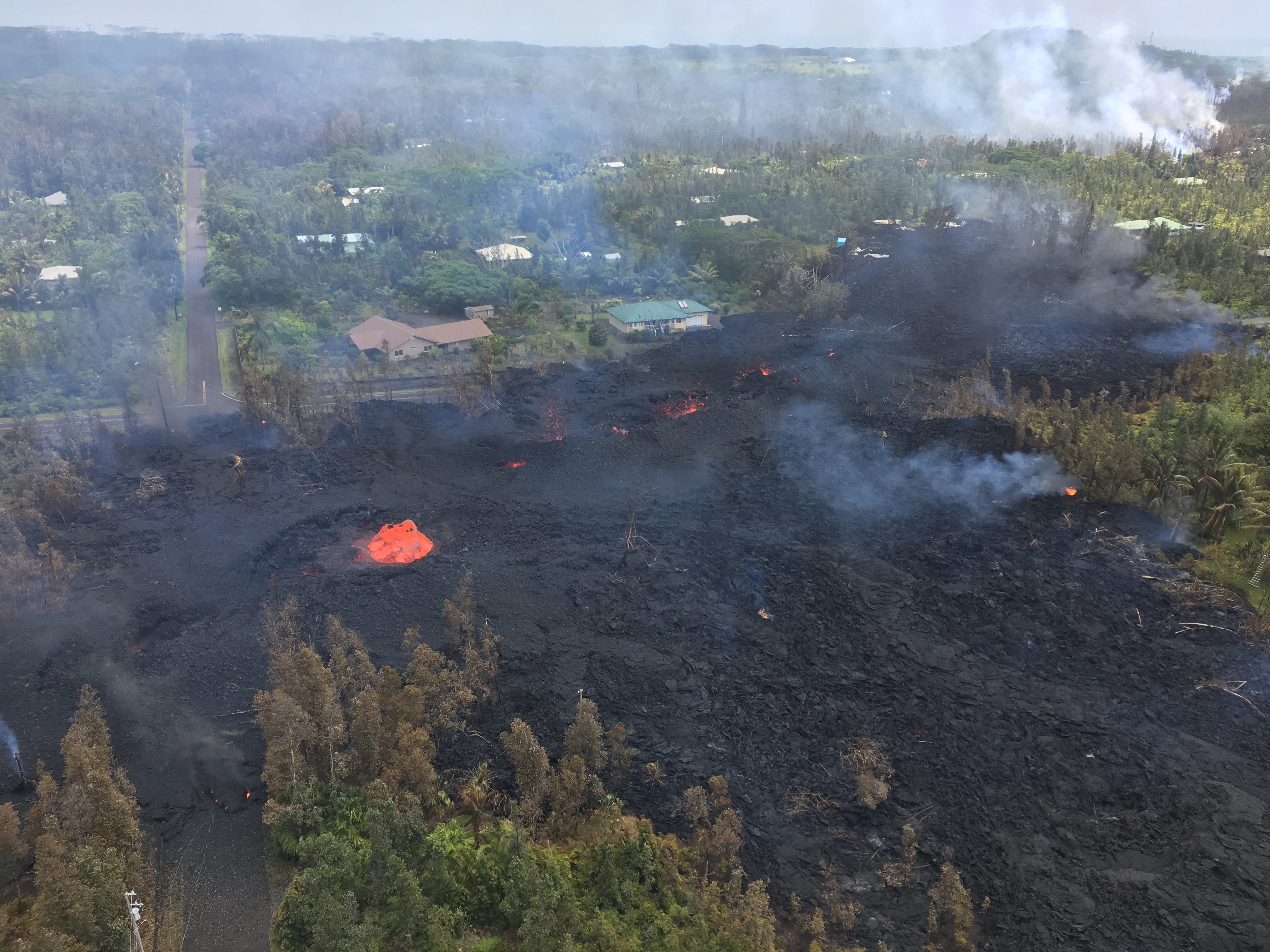
Since he shared such an amazing video, I feel a sense of connection with him and have been hoping his home was spared. BTW, lots of high cost areas have $250-500K homes owned by regular people who live from paycheck to paycheck. My shack is worth a ridiculous sum of money, but that is mostly due to the location of the lot. I half-joke that my lot would be worth more money without the house on it, but it’s more or less true.
I dont know if the house he was standing on was his house, it says he lives in Hilo on his facebook. He probably went on the roof to get a better view of the vent. I think that the fissure that erupted the lava flow was a continuation of the one in that photo, so it seems that is the weakest point so far, or it was the weakest point. Built a pretty sizable cone in only 13 hours of eruption, probably at least 20 meters tall and maybe way more if those are tall trees. Most of the fissures that crossed roads will probably be excavated to rebuild said road, but I think this cone might have to stay… Maybe they can call it pu’u leilani if it is big enough to officially be called a hill.
On another note, it looks like there is a fume source behind the ridge in the webcam, next to pu’u kaliu and the fissure previously shown (or a continuation of it). This one will go south so it might be visible from the ocean or from kalapana.
Also apparently a fissure opened across the highway and is steaming, very likely to become a vent in the (very) near future… Things are getting interesting, I thought it would go downrift but it isnt doing that.
The crack on the highway is probably very close to where this photo was taken on August 14th 2010, when there was an active ocean entry at kalapana (and about the time that I discovered my interest in volcanoes 🙂 )
I dont think anyone there on that day thought an eruption would happen 7.5 years later…
If it jumps that far uprift, I’d say it is more likely to become a main vent. It also appears to be South of the ridge line, so it may drain southwards.
While that is good news for Leilani Estates (and Nanawal Estates), it may be bad news for others.
Well there is also a vent a bit south of leilani that is close to the crest of the rift and could go either way (but probably north), so the fissure that is developing at the highway isn’t the lowest point at the moment which might matter. If the highway fissure erupts then it will go south, and there is a good chance it will reach the ocean as the slope there is relatively constant all the way to the coast (it isn’t like at pu’u o’o where it has the steep pali then a flat plain next to the sea). The biggest vent of the 1955 eruption is only a bit uprift of the highway and this new vent so this area has done big eruptions before in recent times.
The only communities directly downhill of the highway vent is something called the steam vent inn, and an unnamed small collection of houses that might not be in the path anyway, so an eruption here would be much preferred than more fissures in leilani.
In the end though the earth doesn’t care if some adventurous primates decided to build fancy boxes on the side of an extremely active volcano, so we will have to wait and see what happens… 😉
An administrative comment: we have had a number of comments flagged by our spam protector as either spam or in need of approval. That requires an admin to take a look and can take a few hours (or more if unlucky). If your comments does not appear after your submitted it, this is the likely cause. It is not always clear why this is happening, and we can only recommend to limit the number of links in a comment (1 or 2 should be ok) and avoid just giving a link without any text to explain. If this happens to you, please be patient!
https://www.youtube.com/watch?v=3ykkyTgLocA
This isnt a new video (its from July 2015) but it is pretty interesting. Not gonna lie pretty much since I saw a video of someone poking the lava with a stick when there were lava flows in kalapana, I have wanted do do that. Sort of sucks a bit that doing anything to the lava is technically illegal in hawaii, or at least culturally offensive.
I guess I’l have to make an electric arc furnace so I can make my own lava.
It also might come in handy if I ever want to make elemental S block metals for my element collection later, the only one I have is magnesium and I cant buy most of the other ones where I live 🙁
One should not poke Pele with at stick.
When it comes to rules from religions, I believe this is one that makes perfect sense 😉
The furnace won’t help with the S block metals, but works perfektly for burning down the house ;o)
That’s why you put the furnace outside in a place away from flammables m8.
Where I live calcium chloride is actually cheaper than table salt (it doesn’t taste that nice though) which I didn’t know was possible… If you melt it then you can run a current through it then calcium metal should start forming on the negative end, and as long as it is kept below the melting point of the metal it won’t dissolve into the melted salt (probably) so you can keep going. It is actually a lot harder than it sounds to do all this though, you are basically creating hell inside a bucket and adding enough electricity to make you dead a million times over, just to make some shiny metal that is in your bones… 🙂
Electrolysis of melted basalt would be interesting, by that I mean completely melted where everything basalt is made of is above its melting point. Maybe it makes elemental silicon or an alloy of all the major metals found in basalt, probably also oxygen. Might be useful on mars or the moon later on.
The Calcium you form that way will oxidise as fast as it is formed. Same for silicium.
The moment you leave the theory, even chemistry get’s more complicated…
😉
And I really hope you don’t have shiny metal in your bones 😛 😉
If you separated the electrodes into different chambers then the metal wouldn’t be in contact with chlorine or oxygen, and if you can let it cool down without oxidising then it will not react with air quickly and you can put it under an inert gas inside a container.
After that point it is pretty much like magnesium but more reactive with water. It is actually a lot harder to set on fire than magnesium though, which is strange.
I have also looked up the heat of formation of calcium oxide vs aluminium oxide, and there is only a slight difference in favour of calcium, so it might be possible to make it by heating aluminium powder and calcium oxide in a sealed container. I guess this would technically be calcium thermite although I highly doubt it would be self sustaining or very exothermic. Maybe you could also heat fine basalt tephra with aluminium powder and end up with something too, you could call it vulcanium if it doesn’t have a composition that matches an already named alloy.
😉
For boring nerdism:
1) Calcium metal only oxidises quite slowly in air and (like sodium etc) is normally kept under paraffin oil.
2) Silicon is stable in air (luckily for microchios) and slowly forms a coating of silicon dioxide (silica, quartz) which prevents further oxidation (similarly to Aluminium).
3) If you electrolyse a mix of compounds then they come out in inverse order to their electrochemical activity, most likely iron would be the first to form on the cathode and probably CO2 (ex carbonates) at the anode. Quite boring really!
I have heard that calcium metal is stable in dry air and only oxidizes significantly in water, similar to magnesium. It does react quite strongly with water though while magnesium doesn’t at room temperature.
I dont think there is usually enough iron in basalt for it to be selectively reduced first, I think that if completely molten basalt is an ionic compound then either silicon or aluminium would be the main metal and magnesium and iron would be alloyed in, as far as I know all these metals can form alloys with each other and all of them also form alloys with silicon. The only thing that can really be oxidized in the electrolysis is oxygen so that would also form. I somehow doubt that you would actually get much metal though or electrolysis of rocks would probably be the primary source of most of these metals, despite being less concentrated than typical ores. Maybe if you can dissolve basalt in cryolite you could get something?
(cryolite: https://en.wikipedia.org/wiki/Cryolite)
The basalt at kilauea is a bit less than 50% SiO2, so about 20% of the mass of the rocks there is silicon. I think Hawaii has very mafic lava so the percent of iron and magnesium is probably higher than aluminium and calcium, but I dont know exactly, and the basalt at hualalai is alkali basalt which has a lot more sodium and potassium oxides than other stuff.
In reference to my earlier question about making ‘basalt thermite’ I dont think it would actually work because silicon cant be reduced to the metal with aluminium on its own, and there isn’t enough iron or alkali metal oxides* to keep the reaction going, so it would probably need to be done in a high temperature environment.
*yes aluminium will readily reduce both potassium and sodium oxides, the reaction is actually very exothermic, apparently, because of the extremely high heat of formation for Al2O3 vs Na2O/K2O.
I spent about a year last year thinking of everything I could find that might reduce to metal in a thermite reaction, so I have seen quite a lot of videos… 🙂 Still haven’t really done it though, the closest I have gotten is by burning magnesium on sand and getting a black solid that might have been silicon monoxide.
And on with the nerdism 😉
@farmeroz: At 600 to 1000°C things like oxidation get MUCH faster.
@turtlebirdman: the alumino-thermite-way is the way calcium is produced technically. fused-salt-electrolysis is much to expensive.
The good thing is: if you start this and use enough amperes to really get calcium you’ll get a nice blackout…
Al2O3+6Na/K->2Al+ 3Na2O/K2O works, not the other way around and heat of formation is not the only criteria for that. 😉
For the basalt-elektrolysis: no idea, what would come out of that. Some metallic/nonmetallic lump? Loads of flourine and chlorine…at temperatures around 1200°C it might burn quite nicely…
http://www.gocomics.com/calvinandhobbes/1986/08/15
May 8 update added at the top of the post.
Thanks Albert 🙂
Pictures of the cracks across highway 130: https://volcanoes.usgs.gov/volcanoes/kilauea/multimedia_chronology.html
i can’t reach the usgs earthquake site….. is it just me??? or did i break it??? can’t get into the hvo earthquake map either….
They’re quite slow here. Might be a crapload of people hitting the servers.
This report goes into extreme detail about the 1955 eruption. One of its writers was the head of HVO at that time.
https://pubs.usgs.gov/bul/1171/report.pdf
It is notable that the first stage of activity was intermittent like the activity at leilani so far, and was for the most part similar in scale except for two days from march 4th-6th when there was intense fountaining to over 200 meters and almost an ocean entry, a bit like a bigger version of the flow from fissure 8 the other day.
There was a pause of over a week before activity resumed further uprift in the same area as the cracks in the highway, and this area was where the main part of the eruption happened. Is there a GPS in lower puna? it is quite likely showing inflation in the area around the highway as the summit is still draining out and there is no eruption anywhere else except the emptying overlook crater. The leilani fissures -might- be over now though if there is no evidence of inflation under that area. If an eruption occurs where the existing cracks in the highway are located then it could actually send flows in both directions, it is right on the drainage divide.
hallo
Wilkommen DJ Mike, please avoid single word comments, I’ve had to allow this one so your other comment appears in the thread
Does anyone have the link to the webcam in Leilani Estates Please?
Rescued from our dungeon where all new comments go, future comments should post without any primeval
https://volcanoes.usgs.gov/observatories/hvo/webcam.html?webcam=PGcam
It doesn’t do much at night at the moment.
Thank you !!!!!!!
2 more fissures are open. (11 and 12, with 11 not being the vent discussed on the news earlier but a new one.) Each of them follow the line to the west.
The highway 130 cracks have been inspected and seem for now to just be venting gasses. Neverteless, the highway is now closed.
Gas venting is actually bad news. No venting would have been better.
If they are venting gas then it means there is magma below, which means an eruption is possible/likely to happen there. If lava flows north from that spot it actually goes right into the drainage through the middle of leilani which would probably do more damage than the fissures did, if it flows south it won’t do very much although it will probably flow very quickly and reach the sea with a day or two. As said on the link before, there were pauses of up to several weeks with no eruption during 1955, so the fact there hasn’t been a new fissure in less than one day isn’t really very good evidence for this stopping. Really the only way I can see this not eventually ending in a bigger eruption is if it ends up intruding into the puna ridge, like in 1924. That isn’t looking very likely at this point though anymore with more recent fissures moving uprift and ground cracks in the highway. The summit has deflated a comparable amount to 1955 and will probably soon pass that so I think it’s a waiting game now to see where the next vent is.
You can really see how big the 6.9 was, probably as big as all the other earthquakes in this sequence added together…
Most of the quakes in the last day seem to be on the south flank directly below where the crack in the highway is, I dont know what this means exactly but it might indicate inflation of that area, Its probably a bit to far from Pahoa for there to be any deformation there so I dont know if there is any way to confirm this other than it making the most sense. Magma isn’t erupting anywhere but it is still draining out of the summit, so it has to be building up somewhere else and my guess is that it is in the highway area. If my guess is true then I dont think we will have too long to wait before something happens.
Hello everyone,
long time lurker here, I’ve been reading ever since ‘Bob’. The articles here are always informative and the commenters insightful and amusing :).
I am breaking silence today because my daughter found a very interesting rock at the beach yesterday which I think is volcanic pumice. I have put some photos here:
https://photos.app.goo.gl/qQ2vebayGmtPXf1n1
Would the lovely peeps here take a look at it and confirm? If it is volcanic, where could it have come from? Found on the UK south coast near Seaford.
With thanks and best regards to you all,
Nell.
Welcome Nell. Hereby released from the to-be-approved queue, and future comments should appear without delay. – Admin
It should be easy to check if it is Pumice as Pumice floats on water. It looks a bit to solid to be Pumice though.
It is very unusual for the area. It could have come from ships’ ballast, in which case I wouldn’t have a clue as to what mineral it could be. However, it may be slag from metal refining. The location isn’t at all industrial and the geology is very much old sedimentary with not a volcano in sight. But at some point in the past there may have been some kind of foundry – in fact, Wealden clay had iron deposits, as described here: http://www.hammerpond.org.uk/history/history.htm
Thankyou for releasing me!
I checked to see if our rock floats and it does, its less solid than it looks. It was also found at the most extreme high tide point on the beach (which is a tide-scalloped shingle beach). It will have washed up there during the last full moon (30th April).
I’m pretty familiar with the kinds of stone found here and this one is very unusual.
I have picked up industrial slag when I lived in South Yorkshire, which was a coal mining and steel refining area. Slag is quite angular in shape and this stone has a lovely swirled shape with a distinct seam, rather like a swiss roll. It reminded me of the restingolitas which is why I thought it could be volcanic. Also there are no industries anywhere close or even upstream in this area. The Wealden refinery closed in the 19thC and our rock is too fragile to have survived this long.
The wave action on this part of the coast comes from the South West. I’m pretty sure now that this is volcanic pumice, but where could it have come from?
Something I had not heard yet,
“The Hawaii Star-Advertiser newspaper reported that a Hawaii-based utility, Puna Geothermal Venture, had 60,000 gallons (227,124 liters) of flammable pentane gas stored in the area that could not be removed until containers were delivered.”
You can learn something every day.
Because of their low boiling points, low cost, and relative safety, pentanes are used as a working medium in geothermal power stations in some blended refrigerants.
That would have been a pretty big fire if it ever got that far. Pentane is a very volatile liquit, very similar to butane (it has one more carbon atom) and is even more flammable than petrol.
Its also quite a small molecule so I would have thought it would seep into the rock of the borehole so I dont know why it is used as a drilling fluid when you can use things that are less flammable. Maybe it was actually fuel in case it stopped working but pentane is a lot more dangerous than diesel so I dont know.
Probably a narrowly missed disaster if the fissures went a bit further east.
I guess my comment was answered.
I think they use it as the working fluid in the power plant, instead of steam? Use the heated water (?) injected into the ground to heat the pentane.
Water carries much more energy when at 100 C though, and it doesnt catch on fire… It says that it is used as a refrigerant in your older comment above, so I dont think it is actually in the turbines but is there to stop other stuff getting too hot and breaking. I am guessing that the plant will be making a lot more power after this eruption stops, with all that new magma in the area… At least one thing might get cheaper in Hawaii for a little bit 🙂
They use two stages to extract the energy. First a traditional steam turbine, then they use the waste heat to heat the organic fluid (pentane) … I believe they choose this chemical since its boiling point is around 97f so they can condense it using air cooling.
“Ormat’s OEC is based on the Organic Rankine Cycle – a thermodynamic process that transfers heat to an organic motive fluid that is vaporized. The expansion pressure inside a vapor turbine drives a generator or additional compressor coupled to the unit. We’ve significantly advanced ORC science and more than 69 US patents protect our OEC power plant systems, and equipment designs.”
Sounds like cracks are forming further uprift of the highway now. It’s like a reverse propagation!
That is where the ‘T’ vent of the 1955 eruption was, which was by far the biggest vent of that eruption. The lava is still very visible now between leilani estates and pu’u o’o. I actually dont know why it was never given a proper name as it formed a pretty sizable cinder cone.
The main eruptions at the T vent occurred near the very end of the eruption and after a hiatus of 3 weeks, most of the previous activity was small fissures opening between kapoho and the highway, so the current eruption is actually not that different to the 1955 eruption at the equivalent time.
Magma is still draining out of the summit at a high rate so this current activity is still far from over and is very probably not yet peaked, I would give it a week or less before a new fissure opens near the road.
I mean it has only been 5 days and every other eruption in that area has lasted weeks to months so its not really to hard to expect things to keep going.
Has there been any movement on the Hilina Slump?
Lots of steam visible now even around some older rifts.
The eruption has stopped. Though this is most likely a pauze.
Actually stopping at this point would be the statistical anomaly.
It has been one day, in 1955 there were pauses of several weeks so this is nothing so far, although I don’t think it will be 3 weeks before something breaks out at the rate things are going.
Also technically there is still lava exposed to the atmosphere at the bottom of the overlook crater, so Kilauea is still ‘erupting’.
USGS Volcanoes🌋
@USGSVolcanoes
Peer into Kīlauea Volcano’s summit lava lake, now ~700 ft below the crater rim.
How close is that to the aquifer / water table?
Not very close.
USGS Volcanoes on Facebook: The water table is about 600 m (1970 ft) below the rim of the caldera, which is about 1130 m (3710 ft) in elevation.
… That leaves some space before things really get tricky.
Looks like it may impact the geo plant from the webcam
KIlauea deflated by over 10 cm over the past 24 hours. It is going down much faster than Pu’u’O’o. Part of this will be relaxation, where the mountain si still responding to the loss of pressure from days ago. But the fact that it is getting faster suggests it is now draining faster. I think a new outbreak is more likely than not, but it could happen anywhere along the rift. Even at Pu’u’O’o!
I think the overlook crater has actually completely drained now and there are two spattering vents at the bottom that sometimes rise up a bit. It almost isn’t visible in the webcam anymore which is a first for at least 7 years ( March 2011 was the last time this happened I think, although this collapse might still go further as the active vents are at a much lower elevation than the kamoamoa fissure.)
I think all the hot areas that people thought were lava tubes are actually just places where the edge of the vent has fallen into the lake and exposed the hot interior, these places have been submerged in lava for 7 years so you would expect the entire area to be probably incandescent just inside the edge of the crater.
This might allow the edges of the crater to fall in and fill it up, making it wider and with less steep edges.
This will probably make it easier for lava to overflow it in the future too, so the show might not have ended yet. The next few decades will probably be very active at kilauea, it might even overflow halemaumau within the next 10 years if the east rift stops erupting after this event and all the magma goes to the overlook crater.
From the quake patterns, I wonder if there may have been dike propagation to the coast and there is an undersea extrusion going on. Has anyone seen mention of water discoloration off the coast or steam releases? Anything entering the water at less than around 2km depth will generate steam. (pressure is below the critical point of water)
This assumes that there is an open hydrostatic path to the surface from the location at which water is heated to above the boiling point at that pressure. (373.946 °C for 3200.1 psi {22.064 MPa}) Below that depth (and above that pressure) you could heat water to 1100°C and it would not turn to steam. Technically, there is no difference in water and steam in that realm. Since no phase change takes place, I still call it water.
Just out of curiosity, would steam generated at 2km depth reach the surface before the surrounding cold water causes it to cool and condense back to water?
Given a strong enough eruption causing enough steam, I’d assume so.
It mixes with the surrounding cooler water too quickly. About the only time I know that this can occur, is in a geyser. It’s one of the driving forces for geysers and phreatic detonations that make maars. Heat the water above that temperature, and as soon as it gets to a location where the pressure is below the critical point, it flashes to steam. You see this a lot in the quake data for Yellowstone. A large number of “microquakes” are centered around that depth. I suspect that some of the alarmist “quake swarm” stories you see in the press originate in this manner. An alternate method would be a dike finger of magma crossing above the depth of the critical point for water, and interacting with the aquifer. I think the phreatic event in New Zealand a couple of years ago was something like that. (When the volcano that stood in for Mt Doom had a phreatic detonation that sent an ash cloud 6.5 km into the sky and scared the crap out of some hikers.)
Kilauea doesnt do radial vents, at the moment all its activity is along the two rift zones or at its summit, all the fault lines on the east rift are parallel to the eruption zone and it would not make sense for magma to go directly in opposition to this. The earthquakes are probably caused by inflation of the area under the road which is pushing that part of the flank south a tiny bit. Submarine eruptions happen on the puna ridge beyond kapoho, but not on the south flank.
Mauna loa has radial vents because it is so tall that the upper few km can slide in all directions, and kilauea prevents it from sliding towards the southeast (most of the time). Mauna loa is likely nearing the end of its shield building phase and will likely transition to its post shield phase within the next 50,000 years. Hualalai has done this ‘recently’ (about 100,000 years ago) which is why it still erupts every few hundred years and partly uses its rift zone, while mauna kea is much further into its post shield phase and eruptions there are more like eruptions at continental volcanoes (strombolian ashy cinder cones, more andesitic magma) and eruptions there are separated by thousands of years.
Kilauea on the other hand probably isn’t even half way through its shield building phase, and will likely end up looking something like mauna loa in 300,000 years or so. Loihi at that time will probably be at a similar point in its evolution as kilauea is today etc. Loii will probably restrict the movement of the southwest flank of kilauea and lead to radial vents forming in that area, like kilauea does to mauna loa now.
Two new fissures according to the local newspaper:
http://www.hawaiinewsnow.com/story/38087728/new-kilauea-eruption-triggers-house-fires-as-hundreds-evacuate-area
From the news report, it looks like this is between fissures 1 and 5, perhaps a reactivation of fissure 5, with the second fissure close to or reactivation of fissure 3.
PGCam is showing helicopter(s) in the air, but there is no sign yet of “massive” lava fountains as reported in the news.
Thanos Copter?
Not sure I could tell, regardless of how hard I’m squinting, hehe.
For them that don’t know. Thanos, the big bad of the Marvel movies, in an early appearance in the comic showed up putzing around in a helicopter.
… sort of like how the Silver Surfer first showed up as some dude buzzing around a huge battle, in the background… on a surfboard.
The fun bit? I had about 40 to 50 lbs of first issue comics gathered over my youth that got thrown out for space decades ago.
The fissure is apparently right near where leilani street joins onto pohoiki road, between fissure 5 and 6.
Where is black sands subdivision? Apparently there was an explosion there, but when I looked it up on google earth it came up with a beach on the side of mauna loa, which is obviously a pretty long way from lower puna…
Im guessing it is near kapoho if it is an eruption, but if it is anywhere else then it is probably some sort of artificial explosion, like a petrol fire backfiring into an empty tank. The explosion wasn’t from anywhere in leilani or someone would have seen it.
Link? I think this is a likely location where a slump would be first noticed (but it would end up falling off the other side, as the Hilina is buffered, but the bulk of Mauna Loa has far greater mass and is not!!).
It also looks like MOKD is getting a noticeable increase in tremor?
The Live Panorama of Halemaʻumaʻu Overlook Vent Thermal from Halemaʻumaʻu Overlook currently looks like an “eclipse”. Cause by magma lowering?
https://volcanoes.usgs.gov/observatories/hvo/webcam.html?webcam=HTcam
It’s now updated & now doesn’t appear that way. It hasn’t updated yet on VolcanoYT & still looks like what I previously saw. 🙂