We are waiting for developments! Volcanoes can’t be rushed, or forced, and they can sit there seemingly quietly while in reality they are raging on the inside waiting for any trigger that will cause an eruption. Be careful with volcanoes: they will sit there innocently and then suddenly explode in your face. Or not. If there was a geology mental health service, volcanoes would be queueing outside for a bit of support and counselling.
The Reykjanes peninsula was due a significant quake, with many decades of unresolved transform motion. It decided to give way in a segmented way, with several M5 quakes since last year on different parts of the fault. This culminated in a double quake last month. But after this had happened, the earthquakes kept coming. You expect aftershocks, which continue for some days and declining with time. The largest aftershock is typically 1 magnitude lower than the main shock. But this was not like that. The shocks kept coming, in small clusters. This suggests that something more was happening.
The main fault that runs along the Reykjanes peninsula is not a pure transform, but also has a spreading component. That is important. The South Iceland Seismic Zone, further east, is a pure transform fault. It has less volcanic activity. In contrast, the Reykjanes peninsula is packed with volcanic features. In fact, that is how it formed. The peninsula is a long volcanic rift feature, a bit like Puna. The spreading component of the fault allows magma to come up by creating space for it. Pure transform faults, such as the SISZ, are much less efficient for magma transport.
The density of volcanic features shows that the Reykjanes peninsula lacks a central volcano. Features here tend to erupt only once. There is no major magma chamber, just distributed magma pockets with a variety of pathways for heat to come up. The brittle crust in Reykjanes is as thin as 5 km. Reykjanes earthquakes are normally not much deeper than this: they take place in the brittle crust. A guess would be that magma pockets can form near the bottom of this brittle crust.
The magma pockets are fed from the depth. But the peninsula is far from the hot spot in Iceland, and the magma supply is not high. Magma pockets will take a long time to grow to an eruptible size. This is probably the reason for the long periods of quiescence here. The magma pockets do not coalesce into a single chamber, but in a series of smaller ones. Therefore eruptions happen over a range of locations, with many small lava flows rather than one big one.
That is what was happening over the past weeks. The earthquakes created pathways, and some of the magma pockets started moving. Did magma pressure cause the earthquakes? Probably not initially, but the continuation was due to this added pressure, and the moving magma.
Where did the magma move to? There are two important directions. An obvious one is along the main fault. But many of the earthquakes happened on short faults at an angle to the main transform fault. They acted as book shelfs, toppling one after the other. They provide the eventual conduits. These faults run mostly north-south. Further from the fault, they turn northeast, and run along the main Icelandic spreading axis.
Magma moves along the main fault until it feels its way into one of the perpendicular NS fault. Here it will coalesce. It took some time for that to happen, but eventually the magma found the Fagradalsfjall region as the ideal central location. The earthquakes elsewhere died down, but in this area they kept coming.
The strongest earthquakes were at a depth around 5 km where the two faults connected. Magma pushed its way into the perpendicular fault. Now it formed a dike. Dikes are independent structures. They don’t follow a particular fault but take a direction of least resistance. In this particular case, that was northeast, towards Keilir. As the magma reached higher up, the crust breakages were frequent but small. This process is still continuing: the M3 earthquakes are at 5 km, the weaker earthquakes are at a range of depth. (Do be aware that locations of weak earthquakes are often uncertain.)

The current dike is reported to be 1 meter wide and extending up to 2 km depth. The dike follows the perpendicular faults, but at a fairly steep upward angle. The particular fault that is leading the magma is pointing approximately at Keilir. It reached that region, but not much further.
The tremor event a few days put everyone on edge and indicated an eruption was imminent. Even IMO thought so. The tremor was caused by magma flowing along the dike and filling it up. But the magma didn’t cooperate, and it stopped flowing.

In recent days the magma has stopped pressuring the tip and it is now pushing upward closer to Fagradalsfjall. At some point, the dike may find a weakness and comes to the surface. That hasn’t happened yet, but it could happen anywhere between Fagradalsfjall and Keilir. Or it may not happen!
What would it take for Reykjanes to erupt? The region remains primed for an eruption. The earthquakes are continuing. But the main pathway is currently blocked. The likely outcome is still a small eruption, within weeks. This may be triggered by the slow build-up of pressure in the magma chamber reaching some critical point, by an earthquake that breaks the blockage, or by a new inflow of magma into the forming chamber. Renewed tremor will be a sign that this is happening. But if none of these happen, we will be waiting in vain. That is a perfectly possible outcome. Disappointing it would be (for us), but you can’t force volcanoes. Eventually, something will happen somewhere. You just wait. Our sleeping beauty may have gone back to sleep, but one day the prince will come. One day.
Albert, March 2021
Links
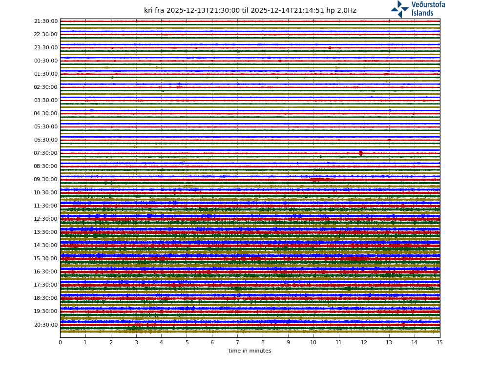
Drumplots. Use KRI or ISS for ones close to the activity. (ISS is not the space station (where tremor would not be welcome) but is near the coast, a few km east of Grindavik.)
Some useful Icelandic words which you may come across in names of locations. Accuracy is not guaranteed.
| icelandic | English |
| alda | ridge |
| á | river |
| aska | ash |
| botn | head of a valley |
| breiða | flat, broad |
| bunga | rounded hill |
| dalur | valley |
| drangur | rock column |
| dyngja | dome or shield |
| eldur | fire |
| ey | island |
| fell (or fjall) | mountain |
| gígur | crater |
| gjá | fissure |
| hnjúkur | peak |
| höfn | harbour |
| hraun | lava flow |
| jökull | glacier |
| kviku | magma |
| lækur | brook |
| melur | gravel plain |
| nes | peninsula |
| öræfi | wasteland |
| reykur | smoke |
| skjöldur (skjald) | shield |
| tindur | summit |
| tjörn | pond |
| vatn | lake |


Watching all the quakes, three plots are interesting, ISS highpass
hraun.vedur.is/ja/drumplot/drumplot/kri_highpass_2.0.png
hraun.vedur.is/ja/drumplot/drumplot/klv_highpass_2.0.png hraun.vedur.is/ja/drumplot/drumplot/iss_highpass_2.0.png
are the 3 plots, but for some reason they did not display in my previous post. (or this one too?)
wordpress allows some images and blocks others. It can be hit and miss. removed the http part so the link at least shows – admin
I cannot seem to post the highpass seismographs, but the 3 stations are ISS, KRI and KLV. All 3 show interesting activity, possibly tremor.
I have lost the Icelandic met office seismographs……. I can only raise the tremor map. can anyone help me get graphs back please?
http://hraun.vedur.is/ja/drumplot/drumplot/
I recommend ISS or KRI
Thank you Albert. I hope you are safe and well.
As safe as can be, far from Reykjanes and Etna.. Nice to hear from you again. We should do these eruptions more often!
Quake just woke me up (in Reykjavik) at 3:15-ish. Has happened like 4-5 times since the swarm started. Getting a bit annoying!
I agree, they seem to prefer going bang at night, although I slept through that 5.1 last night…
The larger quakes last night were quite deep, and a bit south of the previous activity. A bit more of the fault is giving way.
2021-03-10T03:14:38
Breiddargr
63.883
Lengdargr
-22.296
Dýpi
6
Stærð
5.1 M
Your disturber must have been the M5.
Wednesday 10.03.2021 03:14:38 63.883 -22.296 5.8 km 5.1 99.0 2.4 km SSW of Fagradalsfjall
Cowabunga it is 🙂
It looks like there are quakes going a bit south of Fagradalsfjall, actually a bit off axis to the original dike and at almost a right angle to the transform fault. It must be getting very close, there has been elevated tremor for a while now including a 5.1, with magma only 1 km deep before there could be an eruption any moment.
800 years it has been since there was an eruption on land here, and many millennia at this location…
I just love these translations vedur.is icelandic to english (I know there is an english version)
“It must continue to be assumed that eruptions can erupt”
Summary of the night: quakes picked up significantly (20 quakes of M3 or more, with one M5.1), but no tremor or eruption.
So the wait continues.
Is there any word on magma depth now? If it is at 1 km deep then theoretically it can begin degassing, which would be noticeable, and possibly this would set off the eruption.7
It does though seem that in most situations basaltic magma doesnt degas fast enough to directly erupt from depth like this, in fact it probably doesnt degas much at all until it is maybe only a few tens of meters deep. Deeper degassing and high fountains seem to be a characteristic of mature vents, not a feature that causes the eruption in the first place. You can see this very well at Kilauea, where fissure fountains max out at about 100 meters and are usually a lot less, but mature conduits regularly erupt fountains a lot higher than that.
Iceland hasnt had any eruptions exactly like this recently, where an eruption has reached equilibrium and persisted beyond the initial gravity/pressure drive. Low magma generation in most areas explains it but even at Bardarbunga which has high supply of very similar magma to Hawaii and is also a rifting volcano with an open deep system, there are no lava geyser eruptions, its actually unclear to me why this is…
Anyways point is we have all been expecting a sudden violent start to this, magma rapidly rising and jetting out if the ground. But what is really happening is the magma is filling underground space first and it will erupt afterwards, and with very little overpressure. If the inflow rate is 20 m3/s that could well be the eventual eruption rate too which isnt that high. It could beginwith much higher rates if pressure can build up but that will require eruption a bit later on than we are hoping for. At inflow rates 0.1 km3 is about 70 days and that I think would be a suitable overpressure, everything is suggesting an eruption here will happen, but it could be a lengthy preparation. 70 days from now is May 19, lets see 🙂
If there isn’t power from degasing, would it be possible to compress the degased part of the dike/magama chamber (or just build some more pressure) with a tectonic earthquake?
It isnt that the eruption isnt powered by degassing, its that this isnt initially important until the magma is literally right at the surface. There are videos of vents opening in Hawaii with no fountaining initially, but a few minutes later it gets much more vigorous. This is observed in 1955, 2011 and 2018. so seems to be universal to hawaiian style eruptions.
The difference between Bardarbunga and Kilauea might be that one of them has a great glacier ontop that qunches any lava fountains.
Bardarbunga itself is, but eruptions on its north rift are outside the glacier. Unlike Holuhraun or Veidivotn this area also can have direct mantle eruptions, no central volcano required, though im sure lateral dikes occur too. There is a shield here, Trolladyngja, so that might be a long lived conduit that ended up like Pu’u O’o and kept going, probably nearly a century.
Trolladyngja could be a polygenetic central volcano too though its not very well studied in terms of flow ages, tis a mystery indeed, maybe someone should do a detailed study of the age of these flows and others nearby, many are surely very young.
It is pointing roughly in the direction of Keilir. At night,the small group of lights are by the power plant, and the bright strip at the top left is towards Keflavik.
Oops. That was meant as a reply to Jamie asking about the Reykjanes camera on Mila.
I mentioned on the previous page that I think it’s the old rotating one on Þorbjörn, redevivus, static, looking at Fagradalsfjall, Keilir just peeking over the summit plateau. I think it’s a very wide angle lens, so the lights from a settlement may be at Vogar.
It is humiliating when the enemy of the free people has the only quick solution…for worst case… Power or no power…
P. S.: I could need some nukes – pls
https://en.wikipedia.org/wiki/Russian_floating_nuclear_power_station?wprov=sfla1
That was an comment for the comment from Lisabet on 10/03/2021 at 17:05
😉
But we could be lucky – still too much ice around the position of Akademik Lomonosov…don’t have to ask…
Is there almost no ice (glaciers) in Iceland because of the thin crust or because the Gulfstream? Could you ever walk to Greenland in the past 1000? Years not too much ice missing for a bridge – or?
Currents too strong for solid sea ice. Iceland gets the warm stream, but a few hundred years ago that did not reach the north coast and sea ice there was common at that time. The cold stream from Greenland reached there instead. The sea along the north coast has warmed by several degrees since the little ice age.
Then Albert are we back to the arctic foxes…
Bit strange that there are more glaciers left on the warmer eastern side of Iceland, which closer to the Gulfstream but it’s probably because of the attitude…
https://www.newscientist.com/article/dn22262-arctic-foxes-took-ice-bridge-to-reach-iceland/
It is more surprising perhaps that freshwater fish in Iceland survived the ice age
Nothing strange about the location of the glaciers. It is partly altitude and partly the gulf stream. This region gets much more precipitation. Highest snowfall in Iceland is in the southeastern corner. Warmer air contains more moisture. You need snow to grow a glacier.
Still shaking…
Wednesday
10.03.2021 08:50:00 63.889 -22.260 4.0 km 4.6 99.0 1.6 km SSE of Fagradalsfjall
4.6 at 4 km (checked ) Fagradalsfjall.
Yes, and I’m sure you are right about Vogar. Although I am not sure about Keilir peaking over the top -I thought that too, but when the area was sunny, it looked more like a rocky ridge on the plateau. The distant landscape can look very different depending on the light. Or whether I’m half-asleep or not 🙂
Reply ended up in wrong place again!
I just sent them at Mila a question about the placement of that camera.
Also, as of …..1330, it looks as if the pulse is strengthening again. The world may be seeing why it’s called “The land of fire and ice” soon. 🙂
Definitely from Þorbjörn to the east, compare with Gg-Earth:
Keilir would indeed be barely visible behind the ridge in the background (Langholl + Fagradal).
Good grab that. do you have you coordinates from that Google Earth pic?
That would be here.
63°51’52.62″ N 22°26’08.51″ W
Excellent, many thanks.
Might anyone please have up to date live webcam links for the area? The ipcam ones are stuck buffering and must be really busy.
Thank you.
are you talking about the ones from https://www.livefromiceland.is/ ?
the one from ruv is very stable
https://ruvruv3-live-hls.secure.footprint.net/ruv/ruv3/index/stream1.m3u8
The Live from Iceland one is ridiculously zoomed and is almost unwatchable! Thanks for the mention of RUV but I can’t do anything with that link.
Ah – got that link to work now! Cheers!
great! and then there is also this one
https://www.youtube.com/watch?v=8pnkJ-Rb7uE
much farther away in Keflavik
More tremors than all of last year
Today, the total number of tremors exceeded 34,000 in the devastatance that began in the Reykjanes peninsula about two weeks ago. These are more tremors than measured in the area throughout 2020, however, characterised by unusually high seismic activity.
This is stated on the National Weather Service Facebook page.
In comparison, about 3,400 tremors were measured in 2019 in the Reykjanes peninsula, and if you look back to 2009-2014, the number of tremors ranged from 1,000-3,000 per year.
…
https://www.mbl.is/frettir/innlent/2021/03/10/fleiri_skjalftar_en_allt_sidasta_ar/
So, the BBC now has a reporter in Reykjavik and she’s been on one of the main lunchtime radio news programmes (The World at One) talking about what earthquakes feel like. And it’s not exactly a slow news day, either!
Haven’t seen anything yet on the BBC, I presume she will report when they have had enough of Harry and his wife.
Carl obviously forgot that there will be no eruption in Iceland until Operah Winfrey has finished airing!
This was the second mention I’ve heard on BBC radio. You’ll probably be able to find the programme and thence the report via BBC Sounds, but I’d doubt there was anything that you don’t already know.
https://www.mbl.is/frettir/innlent/2021/03/10/eldgos_ae_liklegra/
The IMO is reporting that the chances of an eruption are increasing the longer this goes on. GPS measurements show the dyke continue to expand and also they are indicating increased pressure inside the dyke.
Total earthquakes now over 34,000 which is more than all of 2020, which was a very active year. For comparison, 3,400 were measured in 2019 and in 2014-2018 1,000-3,000 were measured each year.
Hope the eruption waits until the bad weather goes away though 😅
Current activity has shifted south by a few km. An eruption here would have the risk of cutting the coastal road. But I think it is still more likely to be further north. If..
Yeah I saw the authorities and Landsnet power company are thinking about what to do in this event because it could effect electricity supply. Still thought to be most likely further north as you say though.
I took a snapshot off the verified quakes page and definitely activity has shifted to the south and seems to have increased in magnitude this morning here in Pacific Standard time.
https://skjalftalisa.vedur.is/#/page/map shows verified quakes, adjust the time period from March 8th onwards and the shift to the south and increase in magnitude is instantly obvious.
Since there is no central magma chamber that would feed an eruption here, doesn’t that mean that this would be considered a rifting fissure eruption? And if thats the case couldn’t an eruption last a long time and end up much larger than expected; the magma is being fed directly from the mantle right?
Correct feed directly from the mantle and probaly very fluid
Wouldn’t most, if not all, lavas in the Reykjanes Peninsula be MORBs (Mid-Oceanic Ridge Basalts)? Identical, or almost so to those erupted along the undersea portion of the Mid-Atlantic Ridge north and south of Iceland?
Yes thats true
Exactly a fissure eruption along a portion of the dyke that is currently intruding into the crust. The length of the dyke is thought to be around 5km but it will probably be a much smaller section that actually erupts. Hard to know how long it will go on for, I have heard scientists and authorities say in the realm from a few days to a couple of weeks as an estimate.
But yes the lava will be primitive, basaltic, fluid lava.
Yes its not stoored and not evolved in shallow magma chambers.
Reykjanes is far from the Iceland mantle plume Hotspot centra, so any eruption here is not going to be super sized
From my limited understanding, there not many land based events in recent history that can be compared?
The Krafla fires last century maybe (not sure what the magma source was) and what has been observed in the Danakil depression. All these have been rather short and small events.
The Mývatn fires in the 1700’s were more substantial, but again i’m not knowledgeable enough to know the magma source, others on here will hopefully be able to provide more precise info.
Not sure if there are any historic events that are large with a mantle source?
Laki (Skaftla fires) were fed from the Grimsvotn system, so, as with Holuhraun, are a different process.
What about the traps in Siberia and India? Weren’t those mantle sourced?
To be clear I’m not saying this will be even remotely close in scale to those, but it’s interesting.
Yes, but obviously were a very different kettle of fish. 🙂
I assume there are many historic Icelandic lava flows that can be linked to rifting as opposed to being fed from a magma chamber from a nearby volcano, so i wonder what the largest of those are in volume?
Most rifting episodes tend to be underwater, just goes to show how unusual Iceland is.
Even those erupted from magma chambers, just humongous ones. Hawai’i is sitting on top of a mantle plume and that still feeds its eruptions through magma chambers. Remember that the mantle is solid. The melt happens at the top, very close to the crust, and the partial melt has to combine into magma chambers. It may just be a matter of semantics, of course.
what about the formation of the CAMP (is that what its called?) Were there magma chambers for that?
Just curious. :p
I can’t think of any inside Iceland. Krafla is a basaltic caldera volcano and has a magma chamber. So I think it would have to be the Reykjanes Fires 1210-1240, the last eruption on Reykjanes, unless anyone else knows of something else? Of course historic accounts of something that far back are not that great.
Found an article on the IMO website that says:
“Within that period a several eruptions occurred within that system, thereof there were three eruptions in Svartsengi system. The eruptions were effusive (non-explosive) fissure eruptions erupting on 1-10 km long fissures. Historically, the duration of these eruptions spans from a few days up to several weeks.”
oh and “The largest eruption in the swarm, from 13th century, formed Arnarseturshraun lava (estimated 0,3 km3 and 20 km2). “
Yes. Eruptions here are nice sized, large enough to impress, small enough to be manageable. At least in Iceland.
https://ui.adsabs.harvard.edu/abs/2009AGUFM.V24B..02B/abstract talks about Ethiopia, fissure eruptions are ongoing.
In recent geological history, there are the Reykjanes and Krysuvik Fires.
They are in the 13th century Iceland Chronicles according to one of my volcano books. No idea who would have access to them. University of Iceland?
And the Fires were large – enough basalt lava flow in one to produce enough gases to turn the Sun red.
So I would not like to predict how the current scenario will pan out.
The lave huge lava fields around the activities are how thick?
Do they hide more and older lava fields beneath them? About same dimensions?
How big is the possibility, that the magma does not erupt, just the rest of the crust sacks down or get molten?
Lava lake with an island and my new house on it 😁
No tree just a gas tide house…
Like Johnny Castaway
https://youtu.be/g2ZLxtqJuKE
1 m wide…too tiny for an island… 🙁
Actually it will probably have the opposite effect, big fissure eruptions are fed by big magma chambers, and more importantly magma chambers at high elevation.
I think I discovered where this idea came from, as I recently discovered Carls original 4 part series on the 1783 eruptions. That hypothesised the situation of the whole dike being a total rift in the crust and erupting out of the mantle with no central volcano. It is brilliant thinking, but it does appear to have been disproved by Holuhraun and by Kilauea.
Mantle decompression is fast relative to normal supply of magma, as can be seen at Fagradalsfjall now with a temporary very high supply of 20 m3/s (5x Kilauea) but it is nowhere near fast enough to explain the massive fissure eruptions directly, which are in the hundreds of m3/s range, well over 1000 at times. I also suspect the report of a 1500 meter fountain in 1783 was a hot phreatomagmatic eruption as the area is in a river course, and such a high fountain probably happened only at the first vent to open. Or it was just the glow within a steam plume and there was no excessive fountaining at all. The average effusion rate at any one location on the fissure was probably not much higher than at Holuhraun, or at Ahu’aila’au, there were just a lot more vents.
That’s love 🙂
Boris Behncke @etnaboris ·24 Min.
Two minutes of #Etna’s fireworks of last night (9-10 March 2021) on the INGVvulcani YouTube channel. This time with brand-new progressive rock’n’roll music by yours truly.
https://youtu.be/KBW4rM6ouiI
https://twitter.com/Vedurstofan/status/1369615356466233347 shows the 34,000+ quakes on the map of the Reykjanes area. I also came across https://www.icelandreview.com/nature-travel/ongoing-risk-of-eruption-on-reykjanes-peninsula/#:~:text=Today%2C%20the%20Icelandic%20Met%20Office,in%20the%20years%202014%2D2019. discussing the situation.
Kristín Jónsdóttir
@krjonsdottir
·
14m
A trace of surface rupture west of Litli Hrùtur #Reykjanes
https://twitter.com/krjonsdottir/status/1369761147826692106?s=20
The word “Litli” is so neat. Here’s a map, where you can also find Littli Keilir(!):
https://kortasja.lmi.is/mapview/?application=kortasja
moved image to VC as the link seemed quite slow – admin
One of our local Icelanders will be along to correct me if I’m wrong, but I think “litli” is an inflection of the Icelandic word for “little”, and “hrùtur” is, iirc, either singular or plural for “ram(s)”. One of the wonderful things about Icelandic is that a lot of (?most) placenames are toponyms, and sometimes commemorate people and/or memorable incidents.
There’s no snow in that picture – when was it taken?
Hopefull she will respond, as I sent email asking the geographical location and the camera pointing angle of that picture.
https://twitter.com/EIlyinskaya/status/1369760684632911872
Very good explanation by Freysteinn Sigmundsson on
@RUVohf
about the activity on Reykjanes. I *finally* understood how InSAR works.
There was a verry good online course of this man on these topics. Don’t know if they still offer this. “Monitoring Volcanoes and Magma Movements” on edX.
Taal alert level raised to 2. Increased seismicity and increased acidity and temperature in the crater lake. Some inflation and microgravity changes as well.
In trying to track down the recent 5.1 quake, I found that the USGS cannot even get the location of the Iceland 5.1 quake right on their main server, and there was no first motion plot, this is disappointing. I had to go to the CESM-EMSC center to locate the “beachball” for the quake. Two solutions were provided for the 1st motion mechanism. One seems to indicate what we Californians called a “right strike slip quake, with motion away from the dike center (if I am interpreting this correctly) the other beach ball shows a little bit of what I would call upward movement and again a strike-slip movement (mostly).
It would be interesting to get a summary of the first-motions of the larger quakes hitting right now, but 34,000 quakes is a lot of quakes for anyone even with computers and parallel computing resources.
Ref: https://www.emsc-csem.org/Earthquake/earthquake.php?id=957800#map
Hawai’i Island–4.3 on the Kaoiki, and a 3.0 on the SW flank of Mauna Loa. Madame Pele’s girdle is getting tighter…
If a 6+ happens its just a waiting game after that.
It is actually something to consider what a large quake like that would do to an open summit vent at Kilauea, there is persistent inflation so evidently presure isnt being entirely released by the active vent. Its building to something anyway, but a shoce in the side from a powerful quake at Kaoiki would likely set it off prematurely, possibly with spectacular results, a preview of the main event at Mauna Loa. It is looking to be a real competition between Iceland and Hawaii this year, as well as Etna.
The 4.2 quake at Kaoiki actually was not at Kaoiki, it was down at 27 km deep, nearly as deep as the Pahala quakes.
https://www.phivolcs.dost.gov.ph/index.php/volcano-hazard/volcano-bulletin2/taal-volcano/11434-taal-volcano-bulletin-11-march-2021-08-00-a-m
is there any information on the scale of the inflation? I wonder if a lot magma is moving upwards, what ever it is, it looks like its moving quickly.
Looking at the picture here, does this not show a rift along side Reykjanes? So far we were always talking NNE to SSW rifts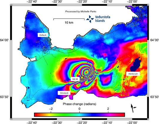
Are smoke and vapour already escaping from cracks and fissures right above the dike there?
It shows deformation uplift/subsidence in the period between two sat overflights.
Caused by magma intrusion mainly, but could be influenced by rift a bit during that intrusion .
Think of a flat square cloth pushed up by hand underneath it (intrusion), at the same time pulled at two of the adjacent tips (rift) -> (You need three hands 😉 ).
https://pubs.usgs.gov/fs/2005/3025/
https://comet.nerc.ac.uk/tag/volcanic-deformation/
good morning and a beautiful view from the Rúv webcam
https://www.ruv.is/frett/2021/03/03/beint-vefstreymi-af-skjalftasvaedinu-vogastapi
I’m surprised how much traffic there is.
Perhaps they just pretend. Only a few cars just go by the cam, turn and pass again, turn again and so on. That way it looks more busy and hence vivid (not just lava). But why? We would love the island anyway…
When the dike rises and magma hits the groundwater table in Reykjanes, will it lead to a phreato magmatic eruption in which a diatreme and a maar are formed?
You think they aren’t already dry? Sulfur, ammonia, etc. steam/smoke and new white minerals could be observed since days…
on the surface…
Not where the activity is now, but it could if the dike goes under the ocean. It also could happen in the future when Krysuvik wakes up, around Kleifavatn, or possibly if Hengil takes part and erupts in Thingvallavatn.
Kilauea in December showed that sometimes a volcano can erupt without any explosive activity even very close to water though, so really it is probably very unlikely for any sort of explosive eruption at Fagradalsfjall now. This part of Iceland is completely effusive outside of eruptions that happen in the ocean.
Just late night check now showed the magma digging a 200 deg dike from Litla hrugar made obvious by looking at the latest verified earthquakes (200 deg by airplane compass)
The earthquakes are still migrating further southward. Also a bit shallower than the last few days.
WOW! 0853, hardest quake I’ve felt in a while. It shook and shook, not a rolling ones like the others.
IMO has it as a M4.5 at 6.3 km W of Grindavík. It was preceded by a M3.3. near Fagradalsfjall.
It was the 4.5. Only 9 km from my house. Caught me by surprise I guess. 🙂
GRV seismograph shows a lot of activity.
hraun.vedur.is/ja/drumplot/drumplot/grv_highpass_2.0.png
This area seems to have the furthest WSW 3+ activity so far. All 3 of these 3+ EQ’s in the same area this morning. Is the dyke expanding or is this not related Albert?
skjalftalisa.vedur.is
I sorted EQ’s from 24.02 to now with 3+ intensity.
Did you hear it?
Not the quake itself, but everything in my house shook for a good 5 secs. It rattled, it felt different then the others that I’ve felt.
The two 4.2 quakes I’ve experienced (Greece and the UK), both made a loud rumbling/roaring sound.
Same for me. I was woken once by a rumble which at first I (sleepily) thought was the underground. Then I remembered this was the desert and the nearest public transport was several hundred kilometers away. It was an M5 and lasted perhaps 20 seconds.
Some years ago i was walking in Spain on a old seabed. My dog get crazy and run away. I turn out at sea and saw like a shock wave came against me. and sound was like a train coming but when pass it get like a bang. little scary. Think it was around 4+ mag just out in sea. Ground very soft was like it float.
The one in Greece made me think they were raising the shutters in the workshop underneath until the shaking started. I do wonder if it was stronger than I found at the time, as there was some damage to buildings on the other side of the city.
Woken, shaking violently, in the night in Bali – initially blaming dodgy local beer. The epicentre was a considerable distance away – nearer Jakarta – but it was a 7.6 so still quite entertaining even at that remove.
Felt a bump in the night when I was camping near the eruption site of the Krafla Fires in 1980. More impressive was a couple of years ago, exploring a route into Stora Hamragil. I sat down to enjoy the view and eat my lunch.
A new awareness grew upon me (to put it deliberately vaguely; I’d never felt anything like it before). I concentrated on it and realised that it was as though waves from beneath where I was sitting were shaking me, a bit like a marble on a tray. I felt slightly queasy. I realised at that point that this was an earthquake and guessed it was ca. M3. On checking later, it emerged that it had been an M3.1, 1km depth and about 3 km from where I’d been sitting.
I bumped into someone a bit later who’d also been enjoying the view, standing near about 2kms from where I’d been. He’d felt nothing – though he also subsequently disclosed to me that he was off his face on acid.
Local lurker here. I really enjoy this blog. I live in an apartment building 3rd floor in Reykjavik. For me the sounds are the worst. For the last two weeks since this began the weather has been rather good so there has been a lot of silence when I’m going to sleep. You can hear a loud roar or rumble (something like the Balrog from Lord of the rings coming from the underworld) followed by wave like 3 seconds later. I have felt earthquakes several time before in this country and I have never been scared of them. But I have to admit that these two weeks have made me a little uncomfortable.
Sounds pretty unpleasant. Below what magnitude do you not hear them?
I mainly just hear them during evenings when things are more quiet. I’m not sure but M4-5 you can definitely hear coming – maybe down to 3.5. It’s a little unnerving because then you have 3 seconds to think “how much will my house shake this time”.
Quakes since yesterday morning. Most striking are the new quakes in the orange area, perhaps not far from the webcam we discussed (thorbjörn).
If you plot the earthquakes from November 2019, you will find that the previous swarms on the Reykjanes Peninsula have followed the same east – west pattern.
Most I’ve experienced during this activity in Iceland gave me a “heads up” before the hit. Kind of like, “Ooo, thats an earthquake”. This one was sudden and like “HI!, I’m an EARTHQUAKE!!”
East and Vertical ground displacements in the ongoing volcano-tectonic crisis southwest of Reykjavík, dominated by strong left-lateral shear and symmetric vertical displacements over the NE-oriented opening. (desc./asc. InSAR data 1-7 March and 3-9 March used in the derivation).
https://twitter.com/Sjonni_KAUST/status/1369884714924920832
Thanks for posting. This rank amateur has some questions as I try to understand the vertical displacement image.
The ground seems to be shown as having sunk where the dike is and having risen either side of it: does this indicate that a graben may be forming? But if so, why has the ground either side risen relative to the wider area? And wouldn’t we expect the ground to be rising at the dike owing to pressure from beneath? Thanks.
Depends on the depth of the magma. It pushes up the ground over an extended area – the deeper the magma, the larger that area (but the less the inflation). Here, the dike has pushed the sides apart and the movement extends close to the surface. It is a little bit of rifting. The rifting lets the centre sink and the pushes up the sides (the rock has to go somewhere). The magma counters the sinking but is not enough and perhaps too deep to counter the central sinking. You see the same thing in mid-oceanic rifts: two peaks around a central valley. The eruption (if there is one!) is most likely to come along the blue region, not necessarily in the centre though.
In this article there is an excellent illustration of what happens when a dike progresses as Albert explains. First you get a depression above the dike and uplift to the sides. As the dike progresses closer to the surface it will eventually form visible faults and a graben. Look further down for an illustration comparing the surface features above a dike intrusion vs a sill intrusion.
https://www.mbl.is/frettir/innlent/2021/03/05/lodrett_kvika_liggur_a_2_km_dypi/
Around 800 quakes detected since midnight. Largest one a M3.4 at 2:10 am. Around 2500 earthquakes detected in Reykjanes peninsula yesterday. About 30 of them were of M3.0 and above, largest one M5.1 at 3:14am. Today, 11/3 at 08:53 an M4.6 was detected around 6 km W of Grindavík
https://twitter.com/Vedurstofan/status/1369955408195039240
Is it possible to tell lava flows apart on it’s contents from different volcanic systems on the peninsula?
The way activity moves around there seems to be no boundary between the so called “systems”, and more like the entire rift zone acting as one?
This page, and the info accessible via it, might be useful: http://icelandicvolcanos.is/
And this zoomable map has been one of my favourites for years: http://jardfraedikort.is/index_enska.html
A wonderful map! And even without having the slightest clue what it means I agree with “Smelltu hér fyrir íslensku” – don’t knwo why, but it just sounds right to me.
Thanks for that map! Invaluable!!
Superb, isn’t it. A great tribute to the map-maker’s craft.
Right back since 2010 on Jon Frímann blog the build up has been great reading and addictive.
I think todays the day, headline news by teatime!
I woke up this morning with that in my mind, also a question. Will this be a first for Iceland if the eruption start is caught on a dedicated webcam?
I think the start of one was caught on a traffic cam or something, a vague recollection.
But a dedicated camera set up to capture the eruption live ?
Weather permitting. Then yes, I believe it will be the first.
actually they got the first moments of the eruption in Bárðabunga on webcam
https://www.mbl.is/frettir/innlent/2014/08/29/upphaf_gossins_a_myndbandi/
It was taken on camera indeed, but while it was something special, the video only shows a bright spot over a black background. You can call me picky.
I am still waiting for a video where you actually see the ground cracking and opening. And with a bit of luck, this time it might become real 🙂
If it happens at night though, I guess the IR cameras dynamic range will not cope with a super-bright heated thing appearing on a relatively cold background.
Theres video of vents opening on Kilauea in 2018, actual video too where it goes from nothing to a tiny flow then a rapid fountain in minutes. This isnt a USGS video though, a private drone video, and to be pedantic it wasnt the start of the eruption at all, but it does show a vent opening where there was not one at that location when the video started 🙂
There is also this one: https://youtu.be/0qZTqp6Qfjc from 2011 that shows the formation of at least a fraction of a fissure.
I completely agree and man that would be amazing thing to see this thing from the beginning.
I was watching when Bárðarbunga started. Just a little flicker of light at first.
It probably depends on where it occurs. The view may be blocked from Vogar and Thorbjorn.
If it similar to Holuhraun which had the formation of grabens and if i recall was preceded over 2-3 days by what looked to be steam release, then with luck they may be able to be set up with web cams in the appropriate spot?
Drone use is also now ubiquitous, so providing the weather plays ball, we may get some footage similar to the stunning stuff that captured the early stages of the 2018 Kilauea eruption?
Agree about problems of getting line of sight to some of the possible eruption sites. Drones could be problematic: I think that they were banned for a while when we were getting excited last week, and Keflavik airport (which still has military use, iirc) is only a few kms away. Don’t know how much traffic it gets at the moment.
Ah! Forgot about the airports being nearby. Then again, if there is an eruption, the airports may be closed to traffic anyway?
The controlled airspace around an airport is typically shaped like an upside-down wedding cake, with the bottom tier having the smallest radius. (This is because approaches and landings come in diagonally, not being close to the ground except quite close to the airport.)
So, if the drones stay below a certain altitude they would be restricted only from the immediate vicinity of the airport and perhaps a bit further when aligned with active approach corridors. Notably, whether the airport fully closes or not, they won’t use an approach path that comes in directly over an eruption — ash or no ash, the heat alone will cause a lot of clear-air turbulence there — so there’s no reason to close the immediate vicinity of the eruption site itself, at low altitudes, to drones, except during scientific overflights of the site — much like at Kilauea.
The current best guess eruption site, near Litli Hrugar (sp?), is fairly far from the airport anyway.
Useful, thanks. And you’ve reminded me that it was during the scientific overflights that drones were banned last week.
Yes of course sods law, clouds, fog bank, the odd sheep blowing by as we have seen before. Anything could get in the way, especially in Iceland. I think the video of the shipping container just scooting off the dockside like confetti got my attention and that was just the wind.
Only if the Icelandic Gods are with us will we get to see the start, if it starts.
I need to see some nice lava fountains and lots of happy official videographers fighting to show us their drone footage.
Crowds of happy Iceland 4X4/tanks OMG’ing at a safe distance.
Remember that beautiful Vimo footage of EJ shot through the derelict fuselage of a DC3, the footage that spawned 10000 new young and old volcanoholics.
I digress …
Mirova satellite is back but without mentioning how many overfligths without receiving data…does anyone know how often per day/week/month the satellite flys over Iceland?
So far no Watts over dedetion limit (kW?) in Reykjanes peninsula. Could also not see the blue lagoon with a water temperature of x °C on the IR map…
https://www.mirovaweb.it/?action=volcanoDetails&volcano_id=371020
Significant explosive eruption at Sangay volcano, ash to 12.5 km (41 000 feet) a.s.l., Ecuador
https://twitter.com/TheWatchers_/status/1369997668206841856
Krisuvik dromplot is off…
 https://twitter.com/TheWatchers_/status/1369997668206841856
The calm before the storm, maybe?
On feeling an earthquake, NY State doesn’t get many earthquakes. So one day in work some who had lived elsewhere were discussing what they felt like and I said I just wanted to feel a small one,no damage o anything. I said that a half hour before we left work, I had no more than walked in the door at home when it felt like a log rolled under the house, it had direction ! I looked to see if a truck went by, no truck, and then the TV said it was an earthquake in the Adarondaks. I know it’s pure coincidence but I still can’t believe I got the quake I asked for and neither could my co-workers the next day.
Visit Zurich for surviving an EQ but don’t forget that is one of the main sources of the terrible 2000 Watt community…
…the devil is not wearing Prada, the devil wears an ETH title:
https://focusterra.ethz.ch/en/museum/earthquake-simulator.html
Quite the coincidence, Ellen!
Here is my story: On April 13, 1992 an earthquake of 5.3 hit the Netherlands at Roermond, affecting Belgium and Germany too. It hit in the wee hours of the night. I had a friend visiting my place near Frankfurt, and it got late. When I was about to sleep I felt the house shaking. I thought: “Oh no, an earthquake! I’m gonna die.” Very frightended, I pulled the blanket over my head, waiting for the walls to fall upon me. But then nothing else happened, and I fell asleep. Next morning I asked my friend who spent the night in the adjacent room whether she has felt the earthquake. “There was an earthquake?” she replied, “oh, I just thought who in your house was running the washing machine in the middle of the night.” 🙂
That one also rattled me out my sleep. I was living some 150km north of Roermond. I remember it as a freight train coming from the wrong direction. Verry impressive. Never experienced one after that.
I too woke up from that one. I was in Amsterdam at the time
Thank you both, I’ve really learned something and have been helped to think geologically.
Aargh! That was meant to be a reply to Albert at 12.12 and Tomas at 13.32.
That Visir webcam is making my head spin. I wish they’d pull back on the zoom a bit. It is like watching the landscape through a Mag 9 earthquake.
Would it be a good idea to hang a mass damper on the cam? Vibration from wind or earthquake should almost react the same way…
https://en.wikipedia.org/wiki/Earthquake_engineering
It would be an idea. In photography we hang a rucksack from the centre hook on a tripod to stabilise and weight the camera against wind and…well…not earthquakes in the UK. I think they’ve taken the link down now anyway.
If everything evolves as hypothesized, 2021 in Iceland could witness two eruptions: Reykjanes and Grimsvotn.
Unless the eruption of one weakens the supply of magma to the other.
I add, and it is my personal hypothesis, that once in place of the lake that currently occupies the Grimsvotn crater, there could have been a lava lake later defined, perhaps during the Lakagigar eruptions as happened at Ambrym in 2018.
I was reading long ago that eruptions in the Reykjanes peninsula occurred around that time.
A possible correlation?
If I look at the seismic swarms that occur in Greip, then in Grimsvotn, sometimes accompanied by a 3.0 or 4.0 in Bardarbunga, I suspect that the events here are not over.
I currently consider Bardarbunga to be the most dangerous volcano in the world due to its semi-collapsed caldera filled with ice.
The formation of a new dam or summit eruption, as seen from cauldrons in the ice, would cause further subsidence.
Grímsvötn is a long way from the Reykjanes …
Bardarbunga wont blow up, if you are meaning that. Theres also basically no one in its blast radius even if it somehow pulled off a VEI 7 explosion, which it couldnt do even if all of the ice in its caldera evaporated in an instant, which also cant happen. I think a lot of people get confused with the eruption of 1477 being a VEI 6 so thinking Bardarbunga is some sort of hidden supervolcano, 1477 was not from the caldera it was a rift eruption, Veidivotn was a lake back then, otherwise the eruption would have been very much like Holuhraun, 4 km3 of lava or so and probably not very dangerous at all.
Things definitely arent over in Vatnajokull though I agree, Veidivotn is going to rift this century again and eruptions there are generally of large scale, at least similar to Holuhraun and probably larger.
It wont be anything gigantic if it derives from Bardarbunga itself, which has a deep caldera and just fed Holuhraun, but Hamarinn could be a different story. I just dont know a lot about it, but it has no caldera which makes it a risk.
Grimsvotn will definitely erupt soon, but just like Kilauea in December it probably wont be obvious until maybe an hour before it happens, so im not waiting for it 🙂 I think it will happen in very short succession after a jokullhlaup from its crater lake draining, which might happen quite soon.
I am not saying that Bardarbunga is a supervolcano, it is absurd to even think so.
I hypothesize, however, that along the edge of the fractures surrounding the submerged part of the caldera covered with ice, if due to an event similar to Holuhraun large quantities of meltwater reached the magma there would certainly be an explosive reaction, I do not imagine a VEI7, but something like a VEI6.
Or, if due to a summit eruptive event, possible due to the presence of large cauldrons in the glacier due to the geothermal effect of the magma near the surface, the pressure under the collapsed edge must decrease, this could trigger a further collapse.
Normally if it were a Katla-like volcano that has a glacier-covered caldera it wouldn’t bother me, but Bardarbunga has much of its caldera sunk at least 35 meters, that’s why I assume a similar scenario.
Obviously mine, I stress, is just speculation.
If I am wrong freely I correct myself.
As for the connection between Reykjanes and Grimsvotn, the only one that would make sense is the splitting process.
I’m trying to find that study that associated (it seems to me) underwater eruptions in Reykjanes shortly after the Lakagigar eruption with this rifting process.
But have they moved Keilir’s webcam?
Grímsvötn and Bárðarbunga are too far away from Reykjanes.
Grímsvötn is primed and ready to erupt. One or two more pushes might be all that is needed. The lake inside the caldera is also at a high level and ready for a draining event. If an eruption happens, the melt water will add to the lake and it will certainly drain and cause a flood. If the lake drains first, the loss of mass on top of the caldera can trigger the eruption, but this is not certain.
Bárðarbunga is recovering after the Holuhraun eruption. As part of this recovery, it is experiencing a slow sequence of quakes around M4.8. One of those quakes should happen very soon. It could be days, weeks or at most a couple of months.
If these events happen close in time, it’s tempting to think that one triggered the other. They are however independent processes and would have happened anyway. In particular, they are in no way directly coupled with what’s currently happening at Reykjanes.
Sooon Reykjanes may erupt …
Waiting for the next swarm magma pulse
Must have the preecciouuuusssss…!!!
They stole it from us…
Shhhhhh been 8 years soon and No show in Iceland!
The next pulse should be starting soon. It’s been six hours since the last substantial quake.
Sneeeeeaaaaaky little eruptions!!!!!wicked… tricky faaalse… .the eruptions cheeat us …the eruptions lies ..
IMO promised usss… IMO woud not hurt ussss …
IMO broke their promise!!!!
wicked tricky false!!!
We needs .. the preccccciooousssss!!!
Patience, Jesper, patience….:D
Settle down.
rúv has changed the postition of their webcam, is it pointing now to Nátthagi valley?
https://www.ruv.is/frett/2021/03/03/beint-vefstreymi-af-skjalftasvaedinu-vogastapi
That looks like a distinctly warm patch of ground on the right hand side, and it looks like geothermally altered clay, too.
The map says it’s water.
I think so. Interesting choice. If the intrusion continues along the current line it will end up behind the camera. The current center of activity is just to the left outside this view.
Actually, that valley is exactly where the tip of the activity is focused right now. It’s very clear in the Skjalfta-Lisa map. Looks like the dike turned slightly east as it progressed south.
New post is up. Today is an anniversary not even Iceland can make us forget.
https://www.volcanocafe.org/fukushima-in-two-volcanoes/
https://twitter.com/Vedurstofan/status/1370051487401906177
Over 1700 earthquakes have been measured in the Reykjanes Peninsula since midnight, few of which were over M3, the largest one measured M4,6 at 08:53 GMT this morning. As before, the magmatic activity is centered around Mt. Fagradalsfjall southwest of Mt. Keilir.
Dr Kristin Jonsdottir of the IMO got back to me on the ground rift picture posted on twitter. I asked for the geographical coordinates and camera pointing direction and she said the location was roughly southwest of Litli Hrutur. She only saw the deeper marks, but drones and other techniques are being used to examine the area. She said that a team conducted by Asta Rut Jjartardottir was looking into the happenings in the area.
Ref: https://twitter.com/krjonsdottir/status/1369761147826692106/photo/1