
Santorini after the 1956 earthquake. Source: https://www.greece-is.com/santorini-like-youve-never-seen-it-before/
Tourists have left, schools are closed. Santorini, source of 2% of the Greece GDP, has been evacuated. There has been continuous shaking for two weeks. The epicentre is 20 km from Santorini and the earthquakes are mainly below M5, but there is a risk that this could lead to a larger event. In any case, constant shaking puts anyone’s nerves up. But what is going on? Is there a reason for this swarm and is it in any way associated with the volcanic history of Santorini and nearby Kolumbo?
Santorini lies in a complicated region. To the south lies a subduction trench where old oceanic crust subducts below the Aegean Sea. That is the main cause of the volcanic arc of which Santorini is the jewel. To the north is the approaching behemoth of the Anatolian plate, the only continental plate entirely located in one country. The Anatolian plate is moving southwest into the Aegean Sea. The northern boundary, the North Anatolian fault, is extending into the Aegean Sea but hasn’t reached Greece yet. The area around Santorini is pressured in different directions. The subducting plate below is pulling north. The subduction zone is itself moving south (rolling back), pulling the Aegean in the opposite direction. And Anatolia is pushing southwest. No wonder this is a broken, fault-ridden region. The mess is centred on Santorini. The plate of the Aegean sea is being split apart under the stress. The split runs from Santorini to the northeast into the Aegean Sea.
The Aegean Sea has a history of large earthquakes. The major eruption of 1600BC which enlarged the caldera of Santorini was preceded by a large earthquake, perhaps 50 years before, which caused widespread destruction. That eruption itself also had tectonic precursor activity, and we know that the island had been fully evacuated shortly before the explosion.
The most recent major earthquake in the region was a double one in 1956. On July 9 there was an M7.2-M7.5 earthquake near Amorgos. (The precise size is not well known: the oft-quoted M7.7 is the top end of the possible range.) The depth was 25 km, which is the depth of the Moho here. It was followed by a deeper earthquake near Santorini which was probably mid to high M6 – again the size is not well known and the quoted size of M7.2 is an upper limit. (The second event can be seen as an aftershock if it was a magnitude less than the main event, or a separate event if it was stronger than that.) This was the strongest earthquake to hit Europe during the 20th century; most of the damage was at Santorini. There was a tsunami across the Aegean Sea which reached a run-up height of 25 meters on Amorgis. The tsunami was assumed to have been caused by subsea landslides, however recently an offset of 10-15 meters has been discovered which is the remnant from that earthquake: the offset may be sufficient to explain the tsunami.
Faults
The island of Amorgos, northeast of Santorini has a steep cliff on the southern side. The cliff descends into a subsea trough which is visible on google maps. The trough is 35 km wide and extends from Santorini to the northeast over a length of close to 100 km. The trough is 750 meters deep. The cliff of Amorgos is part of the northern edge of the trough, called the Amorgos fault. At the far side is the Anafi-Astypalaea fault (I hope I have the spelling right) which runs past the island of Anafi. There are several faults within the trough. One of these is the Santorini-Amorgos fault, which was assumed to be the source of the 1956 earthquake took place.
Mapping of the sea floor has shown a sharp scarp along the Amorgos faultwith a step height of 10 to 15 meters. This would fit an M7 earthquake, and therefore this fault now appears the likely source of the 1956 earthquake. It also fits the peak run-up height of the tsunami at Amorgos. During the earthquake, the fault accommodated extension of around 9 meters. The (disjointed) reports of the tsunami indicate that it started with the water -and perhaps the seafloor along the scarp- going down, consistent with extension. The earthquake was part of the widening of the trough, the break-up of the Aegean plate.
This fault has been quiet since. The extension of the trough has been measured at 4mm/yr. This would indicate that an event of this size may recur every 2000 years or so. There have been earthquakes at Amorgos in 1733 and 1891 which may may have been on this fault or more probably on other faults in the region. The most recent large event was in 42 AD. (Santorini erupted four years later but whether that is related is not known.) (see footnote) And before that, there was the large earthquake around 1650BC. This pattern would fit the 2000 years recurrence time. But this is speculative since we do not know which fault(s) failed in these events.
There are several other faults in this region. The Santorini-Amorgos fault shows frequent small earthquakes and earthquake swarms and is probably able to release its stress adequately. The maximum event from this fault has been calculated as M6.9 but that will be reduced by the frequent microseismicity. But the other faults are too quiet and are likely to release their stress in fewer but larger earthquakes. This has not happened since at least 1919. There is a notable risk of earthquakes of M6 from these faults. This is the reason for the caution by the Greek authorities and is why Santorini was, as a precaution, evacuated.
Current events
The greek word ‘seismos’ (σεισμός) means shaking. It is not specific to earthquakes: it can also be used for storms or even for commotion. It is the perfect word for an earthquake swarm.
Such swarms are quite common within the trough along the Santorini-Amorgis fault. They tend to last for weeks or months, with events of M2 to M3 along a small part of the fault. The cause probably varies. In some cases, especially near Santorini, pressure from fluids (magmatic or hydrothermal) may be involved. In other cases it just resolves some build-up stress.

Source: Leclerc, F., Palagonia, S., Feuillet, N. et al. Large seafloor rupture caused by the 1956 Amorgos tsunamigenic earthquake, Greece. Commun Earth Environ 5, 663 (2024). https://doi.org/10.1038/s43247-024-01839-0. (This article is licensed under a Creative Commons Attribution-NonCommercial-NoDerivatives 4.0 International License.)
The plot below shows earthquakes of M2 or stronger in this region. It was created using the database of the University of Athens, available from http://www.geophysics.geol.uoa.gr/stations/maps/recent_eq_2d.htm. The colour refers to the depth: the shallower ones (less than 15 km, i.e., in the crust) are in red, orange is 15 km or more, yellow is more than 30 km, green more than 60 km and blue more than 100 km. Do be aware that both the location and depth can be inaccurate: some of the scatter in the locations is instrumental. (Also, if using the USGS earthquake maps be aware that their locations can be off by 10 km or more in this area. It can be better to use local resources.)

The annual maps show distinct swarms. In 2018/2019 there was a swarm southwest of Amorgos, with some deeper earthquakes which lasted from November to December 2018. There was also a swarm just south of Santorini in January 2019. Santorini itself was neatly avoided, suggesting this was purely tectonic. 2020 was calm, but in 2021 there was a swarm northeast of Santorini. It started in February and continued episodically until May 2022. 2023 was again quiet and 2024 saw a small uptick in the region between Santorini and Amorgos. But notably, there was a swarm focussed on the Santorini caldera, in the same region where there had been activity and uplift in 2011/2012.
The weak swarm in 2021/2022 occurred at the Kolumbo volcanic centre. This region has shown such activity before. The faults extend to this area and it is difficult to distinguish seismic activity on the faults from activity associated with the volcano. The earthquakes were mainly below the magma chamber (which is 6-7 km deep) and it has been suggested that they were caused by magma migration into the chamber. The volcanic activity occurs on a line running SW to NE which is parallel to the faults and the trough, indicating a relation. The faults allow easier magma migration. This is the reason why tectonic swarms carry a potential (but unproven) connection to eruptions. The formation of the Nea Kameni island in the Santorini caldera was associated with the earthquake of 1707. But the much larger earthquake of 1956 did not cause any volcanic activity. This is perhaps because the 1956 event was on the Amorgos fault, while the Kolumbo-Kameni line of voclanoes is associated with the southern extension of the Santorini-Amorgos fault. This is speculation, but the microseismicity may indicate that this fault is better lubricated with fluid!
Back to 2025. Why are we so excited about a swarm in an area where they are frequent? The following plot will show. It is the same as the above, but now for 2025 up to Feb 8 only.

The 2025 swarm far exceeds the earlier ones – and has done so within only two weeks. Over the two years of 2021 and 2022 there were 170 registered earthquakes of M2 or stronger. Since the sudden start of the 2025 swarm on 27 January until mid-day on 9 February, there have been 1006 such earthquakes. Of these, two were M5 and 120 were M4. I see no evidence yet for a decrease in activity. There have been 6 M4’s already today (Feb 9).

The earthquakes of M4 and M5 are presumably the ones with the most accurate locations. They are located at depths of 6 to 8 km, across a region at the centre of the trough extending over some 10 km. The location agrees with the Santorini-Amorgos fault. Note that the region is also well separated from the Kolumbo volcanic centre. There has been no known volcanic activity in this region, to the best of my knowledge. And, as our own expert Mike Ross commented, none of the events show any indication of fluids: they are solidly tectonic. This is a fault doing what it does best: faulting.
There can be little doubt that if this activity had come in one big event, it would have been a damaging earthquake of (I guess) high M5 to M6. The Santorini-Amorgos fault is releasing pent-up stress in a long-lasting tantrum. A tantrum is better than an explosion!
Future
Does that mean everything is fine and people can return home, invite the tourists back in and re-open schools? That is not for VC to decide! But in my opinion, it is better to wait a little longer. There has been no earthquake activity near Santorini. Is this movement increasing the stress there, with a larger likelihood of a more major event? It is too early to tell: give it another week. Could this affect the other faults in the region, which have been locked for over a century? That is possible but a much harder problem to handle. It could just mean an elevated risk of a large earthquake over the next year: it is impossible to continue an evacuation for that long with such a vague reason. it will instead require earthquake-proving as many buildings as possible.
Does it increase the risk of a volcanic eruption in the region? It may take years before we know. There has been a little increase mid 2024 in the Santorini caldera which perhaps was related to the build up towards the current seismic storm – it is hard to know. If the current swarm is releasing stress and is enjoying a bit of rifting, it may make magma rise a bit easier even as far away as Nea Kameni. But that is not a significant change to the situation before. The Santorini caldera has erupted 5 times in the 18th to 20th century. It is reasonable to assume there will be one or two eruptions in the 21st century as well. That expectation does not change.
But there is one thing to note. This swarm happened in the winter when few tourists were present. The 15,000 inhabitants could be evacuated. But how about a busy summer day when people can’t move from the crowds? How quickly could an evacuation take place at that time? That is something which I expect Greek authorities are thinking about – and perhaps losing a bit of sleep over. They have done well, in my opinion. But they may have to rise further to the occasion.
The bottom line is that this seismo-storm is a good thing. It releases stress, it attracts attention to future dangers, and it is non-volcanic. What more could we wish for?
Albert, February 2025
Further reading
Santorini: Beauty and the Beast
Footnote: This earthquake in 42 AD is mentioned in Leclerq et al, 2024, based on a catalogue of historical events. Having looked up what is known about it, I have severe doubts about the veracity of this claim. It seems this event, if it existed, may have happened in Turkey rather than in the region of Santorini.


Good update! I have canceled my long planned Santorini trip for now!
I am sorry to hear that. Go in April: good time of the year, the trouble should be over or mostly over and there my be more space because of cancellations.
Good piece. 2% of GDP is a lot. Thank you for the moving black-and-white movie from – I guess – Amorgos. Reminds me a bit of “Zorba the Greek”.
Been reading about snowstorms and snowfalls in Wyoming and Colorado, up to 40 inches, last 2021. 100 years ago they called them “equalizers”. If somebody had 50 sheep (poor farmer) or another one 900 sheep (rich farmer) the result was the same. In case that went on for a while the result was zero sheep. Some lost their existence. Hard life.
The movie shows images from Santorini where most of the destruction was, including all fatalities. Whether the song of the secret garden is the most suitable soundtrack is debatable but it is a moving composition.
I first thought (before watching the video) that it was this “Secret Garden”:
https://www.youtube.com/watch?v=NdVl6SjZrNA
Some may prefer the live-version: https://www.youtube.com/watch?v=j22yGo-6nO4
Turkey is worried as well. Bodrum, also beautiful, could be threatened by a tsunami and had a 6.6 earthquake itsself, together with the Greek island of Kos, in 2017.
https://fakti.bg/en/world/946695-turkish-seismologist-warns-70-magnitude-earthquake-could-trigger-tsunami-near-kusadasi-and-bodrum
https://en.wikipedia.org/wiki/2017_Aegean_Sea_earthquake
But Bodrum has s.th. else: A caldera.
Eruption estimated between 11.2–9.3 Ma.
“According to our field data and image analysis, the Bodrum Peninsula exhibits an ignimbritic caldera with complex collapse and resurgence mechanisms.”
https://www.sciencedirect.com/science/article/abs/pii/S037702730400112X
Pictures of the caldera system in here:https://www.academia.edu/19871326/Volcanic_and_deformation_history_of_the_Bodrum_resurgent_caldera_system_southwestern_Turkey_
Thx for the post. Seems that there was just another 5.0?
http://www.geophysics.geol.uoa.gr/stations/maps/recent.html
yes indeed. 6 km deep – it fits in perfectly with the crowd
As it seems to be pretty quiet right now – some M4 between Caiman Islands and Honduras, probably afterquakes after an over M7 quake and some M3-4 quakes around Anafi, an island between Thera and Amorgos – it might be the time to come up with a question that occupies my mind since at least two years ago. In case you ever answer this, take your time. I believe that it is also important to – just in case the q is valid – think unconvetionally like all great geologists did at their time, people like W. Jason Morgan, Princeton, when he presented his paper called “Rises, Trenches, Great Faults and Crustal Blocks” in 1968, or when J. David Love, later USGS Wyoming, was invited to present his thesis about Tertiary Rocks in the Absaroka Range which challenged the views of the established geologist Taylor Thom who happened to get up first, saying: “This paper is a milestone in Rocky Mountains geology.”
Nevertheless, my q might be stupid. It is basically two q. By reading some of the great W. Jason Morgans work or about it I, of course had to stumble about the Great Meteor Seamount and the track back to the New England Seamounts, further back into New Hampshire and into Quebec and, questionnably even further back into Canada.
Now, the problem is only that the assumed last seamount in the chain is sitting on the African plate which is somewhat slobbily explained as the rift travelling west. I know that rift jumps are known, i.e. in Iceland. But then they change direction. Now this rift, the MAR, sits still very neatly parallel to the big bay between Newfoundland and Florida and also the the bulk of Africa between Ricks Cafe in Casablanca and Liberia and at ~ equal distance to both. So I would put the Meteor track back to the Canaries (volcanism begun 70 Ma) and after that to the “Eye of Africa” in Mauretania.
Another possibility is – and this is my question – whether there is s.th. like an “American/African Plate” in that area at all. Where is all that newly (well, since the Mid-Jurassic ~ 185 Ma) produced oceanic crust? Shouldnt there be two oceanic plates in place like Nazca east of the EPR and the PP west of it? Then – maybe – the GM Seamount on the other side might make some sense.
And the older subquestion is: Why the heck are the African and the American Plates always in the same place in all maps about the area since 185 Ma?
This is really an enigma to me. If you have no time or interest to give some ideas now, I understand, but would be quite happy if you got back to it one day, maybe with a piece.
Thankyou and greetings
This looks a lot like one of my musings – a bit hard to read I’m afraid,.but almost certainly not a stupid question 🙂
Clearly you know exactly what you mean but you might want to rewrite that – or expand upon it to spell out to the idiots (like myself) in the audience what you mean more clearly.
Last seamounts in a chain are at both ends – so I presume you mean the newest seamount (rather than the oldest one?)
Not quite sure – are you saying that the seamounts point back from the MAR toward the eye of africa?
On the other question regards two plates being in one relative position I’m guessing that might be a feature of animation needing somewhere to ‘stand’ when drawing all the relative motions – something is always going to be the centre if you are animating plate movements – you could pick the poles for orientation I guess, and if you’ve picked something to stay still and two things happen to have little relative motion those would both appear to stay still. But I might be wrong about that too ?
Gladly.
With the last (youngest) seamount I mean the Great Meteor Seamount.
I am not so ready to easily believe when s.th. does not fit that it helps to throw the MAR to the other side. So, I constructed a track back into Africa.
W. Jason Morgan, a really great geophysicist who, btw. had studied and dissertated in Physics, but sat in the same working space as Frederick Vine
https://en.wikipedia.org/wiki/Frederick_Vine
in Princeton became enthused with Plate Tectonics and staid in Geology in Princeton.
So this is difficult as W Jason Morgan is sort of a Holy Cow. He was very daring though himself, ready to put his own assumptions under scrutiny, and very modest, so I guess he would maybe not mind.
Fred Vine who he had been working with described as a PhD for Drummond Matthews (in Wiki link) the symmetrically spreading ridges. Symmetrically.
All I am saying is that the Great Meteor Seamount might belong to the other side.
What I said about plates is obvious. It should be called Atlantic Plate maybe, possibly everywhere, also, i.e. near the Puerto Rico Trench. It should be oceanic crust, created in the MAR (Mid-Atlantic-Ridge) and is now ~ 185 million years old. And therefore it should also be lying in a greater depth, as oceanic crust is denser than continental crust. And if it were continental crust there would be no 310,410,900 km3 of waters on top of it. The Puerto-Rico-Trench has a depth of 8.400 m.
I am just saying that there are inconsistencies. So lets see, if Albert tackles it one day or not.
Also:
https://www.volcanocafe.org/terra-nova-the-eye-of-africa/
written by Albert
I would like to add this (rift-jumps yes, but older):
“Modeling results indicate that this jump occurred between 164 Ma and 159 Ma (Chrons M38 and M32)”
https://pubs.geoscienceworld.org/gsa/geosphere/article/3/5/282/31160/Early-Central-Atlantic-Ocean-seafloor-spreading
The rest I will study later, time-consuming.
Just the right lighting, dark but before the infrared mode turns on 🙂
Very earie luminous orange glow.
Thanks a lot for the post! I have been waiting eagerly for someone to write one (checking every day), and appreciate you taking the time to share your insight Albert!
Very nice to have such a well researched and cogent explanation of what is going on! Thank you, Albert!
A 5.2 now indicated on the quake list of the University of Athens (still an automatic assignment of magnitude). Would be the strongest one during this campaign.
And another m5.0 last night. But the earthquakes are moving north a bit, away from Santorini and towards Amorgos. That is good news for Santorini. It may also mean the swarm is getting closer to its end.
There was an animation of the quake sequence posted on the volcanocafe facebook page (https://www.facebook.com/100001993305208/videos/998399075685442/) showing that the activity moves back and forth along the fault line. It could easily switch back towards Santorini again.
Very nice illustration and sequence, I am wondering if the sharp edge/stop at the south west side might indicate that a large event is needed to relieve stress from that side?
I gave the past 300 years a quick look. Concerning earthquakes the Ionian Sea was always more active, and then west, of course, the Strait of Messina.
There were a few near the Turkish coast, Amorgos was already mentioned, Chios further north along the coast, 3rd April 1881, death toll 7.866, the worst it seems.There was one in Paphos, Cyprus, 6,5, on 10th Sept. 1953, death toll 40. This is interesting as it happened three years before the Amorgos earthquake and is not too far away. It is outside, that is to say south of the subduction zone though, so the timing might be purely accidental.
Volcanism is sparse too in comparison to the Messina-Etna-Stromboli corner.
This one is an islet (Glaronisia) north of Milos, about 80-100 km WNW of Thera.
And I think that the island of Milos has an interesting shape:
Then there is Nisyros, once, time ago mentioned by I believe Quinauberon here with eruptive periods with small eruptions over a period of 150.000 years.
Stefanos crater:
Nisyros is located further east near the Turkish coast.
Then there is Gyali near Nisyros, this pumice is thought to be from the Neolithic Period:
Then there is of course Kos near Nysiros and on the Western side the Methana-Peninsula near Athens with 32 volcanoes that have started to erupt yesterday (1 Ma) and are thought to have erupted last 300 years ago near Kameni Chora, submarine.
Another island with an interesting shape is Chios, but this island is further north west of Çeşme:
Some more to Milos. Volcanism 2-3 Ma (not enough research?) to 90Ka.
“Extinct volcanoes can still be seen at Firiplaka while the circular gulf of the island is considered to be a submerged caldera.”
https://www.geoengineer.org/education/history/milos-island-working-with-earth-for-9000-years
Why the Geofon site indicates Dodecanese as the location of the earthquakes if Santorini is a part of the Cyclades archipelago ?
https://en.wikipedia.org/wiki/Flinn-Engdahl_regionalization
There is a new lava flow on Etna, from a vent on the side of the Bocca Nuova.
https://www.facebook.com/share/18q4uVYbJ5/
Its pretty visible on the webcams
https://www.skylinewebcams.com/en/webcam/italia/sicilia/catania/vulcano-etna-sud.html
Its a weak flow, no fountaining, so there must be shallow magma in the BN right now too.
Video of it up close, the lava really is just flowing out of a hole in the ground silently.
https://youtu.be/G7ao55Eyqw8?si=EqGNVMIum6BN6Ro7
Looks like we might get another episode at Kilauea here shortly
Probably going to go up tomorrow.
HVO has released another reference map, the current eruption is 40 million m3.
https://www.usgs.gov/media/images/february-7-2025-kilauea-summit-eruption-reference-map
There have probably only been about 14 days total of actual eruption, so the average eruption rate is probably about 33 m3/s. The peak eruption rate near the start is probably multiple times higher though but its hard to find any data on it.
The average eruption rate over 50 days is 800,000 m3/day. 15 million m3 has erupted since Jan 15, and pressure has been at equilibrium that time, so the real level eruption rate is just over 500,000 m3/day.
At this rate the 2018 caldera will overflow into greater Kaluapele, in around 1000 days, or in early-mid November 2027. Filling the entire caldera to overflowing might take another 5 years at max if filled as a rising lake, a shield at the new vents will probably top the rim in 2028. Its crazy.
Is it technically possible to fill the whole caldera? I am envisaging Nyiragongo whereby when it gets to a certain level it triggers a drainage event. The localised magma must weigh heavy on the nearby rock.
It did before, and not in the Middle Ages but in 1921. Other point is more that the caldera will overflow before 2030 unless it has a flank eruption
It is worth saying that the pressure at the summit now isnt low, it is lower than in December, but still much more than what triggered any of ladt years rift intrusions and eruptions. An open hole is better than gravity it seems.
Im also going to guess, but Halemaumau probably could have filled up much higher in 2018 than it actually did, if Pu’u O’o wasnt there still open half way down. Its hard to say right now given both rifts erupted in the last year but this vent could probably quite easily get much higher up than 1 km elevation. But it will also be a test when it does, will rift activity immediately resume even with the open vent. If not, then the caldera is no more by 2030.
I still see people saying it will be decades or centuries to overflow. Thats because magma has been going to the ERZ, put it at the summit and its going to fill very fast. Pu’u O’o would have erased the caldera by the turn of the century if it was up at Halemaumau. This is exactly that scenario right now, just very early on 🙂
Remember, theres only been 5 open vents like this in Kilaueas recent history, they all only got destroyed under catastrophic circumstances, either a lower ERZ eruption or major quake, or both. And 3 lasted for years or decades, maybe over a century. This is already 6 weeks and restarted 9 times, if it was going to close it would have done that last year, like the other summit eruptions.
Right on time, starting to overflow now, lets see if it goes past the rim in an hour 🙂
Yep, getting some big fountaining.
Is is already warming up for the next episode:
“Kilauea Message 2025-02-11 04:08:36 UTC
Occasional spatter from the north vent has been visible since this morning, February 10. Inflation continues at the summit and glow intensified last night, indicating that the magma column is rising within the vent.”
On the webcam the steam is very bright illuminated by the glowing vent, and I can clearly notice spattering now. https://www.youtube.com/watch?v=oG5zz9Sjw3E
While Santorini screams before doing nothing. Ioto is erupting again it’s 4 magma eruption over the last year
“Historic Santorini eruption pales in comparison to ancient blowout
Evidence for huge underwater eruption 500,000 years ago, part of a still-active volcanic arc in the Aegean”
https://news.berkeley.edu/2024/01/16/historic-santorini-eruption-pales-in-comparison-to-ancient-blowout/
Nice seafloor map in article
Thanks for the update on Kolumbo, Albert!
The tectonic earthquake threat is at the moment the only actual one. A possible major earthquake after a swarm of moderate foreshock earthquakes looks like the most realistic worst case scenario at the moment. But maybe they’ve luck and the earthquake crisis calms down without a big bang.
This is a picture of the Hoggar Mountains, Algeria, with the Atakor Volcanic Field in it. I am using it to draw the attention to an older piece by Carl about neighbouring mountains in Libya, then again south-east neighbouring mountains in Chad (Tibesti) and the other African Rift System which Carl thinks, dissects the so-called (more known) African Rift further south-east in or near Lake Turkana. This Rift is the Great African Rift.
https://www.volcanocafe.org/the-forgotten-volcanoes-of-libya/
This is vintage.
“The Pan-African orogeny affected the entire trans-Saharan belt and resulted from an early collision (750–660 Ma) to the east with the East-Saharan craton and from a late collision (630–580 Ma) ”
https://www.sciencedirect.com/science/article/abs/pii/S0024493798000346
Then it starts erupting again in the Holocene. It has fumaroles.
It is a mystery.
Scientific paper from the Berkeley Media for who is interested and has missed it in the article:
https://www.nature.com/articles/s43247-023-01171-z?error=cookies_not_supported&code=1946924c-7f8b-4ced-9de8-ad0cccfaaa81
Kilauea is starting up again. Small fountains and flow starting.
Eruption has resumed at Kilauea. Fountains very low right now but lava is pouring out of the crater: https://www.youtube.com/live/oG5zz9Sjw3E?si=Y_iTcjS7g2a1VHhD
Going full steam now. Just moved the camera to catch the top of the fountains.
Yes indeed, that escalated quickly!
Look at it now—there’s a sale on Pele’s Hair and assorted rephra!
Rimd Looks a little more intense than previous tremor.
SDH shows the tremor increasing. RIMD has stopped reporting.
They have adjusted the scale on SDH so the different lines do not overlap.
B2 cam shows the height well.
Yes its just about the height of the wall, so maybe just under at level view. Still already way higher than 100 meters that HVO will probably say it maxed out at 🙂
Not the easy 300 I was kind of hoping for though but the south vent could be blocked up by a rockfall at the end of E8, still early but if it stays closed then all the pressure is through only one vent now.
Same height as the rim from S2 cam, which is level with the top. So either the cliff is actually only 100 meters tall or the fountain is +200 meters right now 🙂
330 feet in the latest Kilauea message.
Wall is 190 meters tall in that section, considering the 950-meter height of the lava lake. So some spurts are probably reaching 200 meters or more. Still, HVO measures the sustained height of the fountain, which has always been their policy, and they might only be considering the part above the cone rim which is an obvious underestimate, but idk.
Its never made clear though, and the sustained height isnt half of the peak either, so their number is still probably way too low. They do have some weird definitions for things sometimes that arent intuitive or actually defined publically, and conflicts with locals over technicality.
In 2022 they said no lava was erupting on the SWRZ, which was technically true but lava did erupt southwest of Mokuaweoweo so a bit of a moot point to the people downhill.
Buenas tardes, Hector, I found this interesting piece of yours here on VC
https://www.volcanocafe.org/batholiths-and-flare-ups/
and would like to ask: is this you?:
“estudió Secundaria Obligatoria en Escuelas Pías de Jaca. Durante esta etapa fue seleccionado para participar en la Semana de Inmersión en Ciencias de la Universidad de Zaragoza por la especialidad de Geología. Ha cursado el Bachillerato en Madrid, en el IES Alameda de Osuna, centro con el que se presentó al Geolimad y a la Olimpiada Nacional de Geología”
Hi Denaliwatch. Yes, that is me, though I’m not from Jaca as that news might make it appear, I was there only briefly. I remember 2018 fondly for some reasons, including this and the discussions in volcanocafé over the Kilauea eruption.
About batholiths and flare-ups, it does have some good things as well as the follow-up posts, but I no longer think the mush way of seeing everything volcanic is correct. That tomography may be blurring smaller structures, and that geologic evidence of old intrusion complexes, particularly well-preserved intraplate ones, are more consistent with plexus of sills and dikes, and melt-rich laccoliths being the interior of volcanoes.
Thank you. Good to know where you are coming from, they must be brillant in Madrid as you always write very logical, very knowledgeable and very well thought over stuff. I want to give you s.th. Please ignore it being old. Spencer H. Wood is retired now. He is from Boise. I realized that those geologists from the areas concerned were very good, knowing the places well. No need to answer to me, just s.th. to think about. The first link is bone-dry reading – I am not finished yet. Take a look at Figure 6, ten pages down, esp. the date of Double Mountain.
https://idwr.idaho.gov/wp-content/uploads/sites/2/projects/north-ada-county/199807-WOODCLEM-2002.pdf
I also add in my brain the big obstacle in the way:
The Snake River goes around it south-, then west-, then north-bound, the Salmon River of Idaho takes north first, then west, crossing between the two parts of the batholith, north of the Atlanta Batholith. Both rivers are nicely embracing the Atlanta Batholith.
The eastern Snake River Plain has been known for moving up and down in the sense of uplift and subsidence and had times with little and others with lots of sediments.
I believe it is much to easy to just give the area a mantle plume which would also mean that part of the American Craton would have moved 180 degrees like a carousel. I think the area should have more research from different viewpoints. And I assume that this might be difficult because there are now two National Parks in a row, YSt and Teton, and much of the research done in interesting areas has always been financed by (drilling) companies interested in Gold/Silver/Uranium/Oil/Gas and nowadays Lithium and other rare earths. In NP no drilling. The fight between Utah (high unemployment) +Republicans vs environmentalists+Democrats about the north-eastern Escalante area shows this quite clearly.
As I said, no answer necessary, just some material to think about, and I am not saying there is no mantle plume, I am just saying there might not be enough local research and enough thinking about it. Another scientist I am reading I will not mention as I was attacked for it here a few years ago which, in science, is known, but not very helpful. I am coming from Radiology btw, although I have forgotten most physics and radiochemistry, it is not the worst starting point for this hobby. Saludos
Thanks, Denaliwatch.
Yes, I do agree that more critical thought is needed. Yellowstone’s origin itself takes place in a specific setting and moment, the Basin and Range formation that is likely also related to the start of East Pacific Rise subduction under the continent in an area with a trajectory of intraplate/back-arc volcanism due to its geologic evolution (the Absarokas which probably had a hotspot progression, the Montana Alkalic Province, and the line running from the Black Hills to the volcanoes in Arkansas and Mississippi that may be some sort of track). But it’s hotspots and volcanism in general that still has many unexplained aspects. The biggest mess is perhaps the Benue Through and all the generations of intraplate volcanism that small area of lithosphere has sourced, from the Jurassic Nigerian ring complexes to St. Helena, then Fernando de Noronha, the volcanism of Annobon-Sao Tome, and Mount Camerroon-Bioko. Though most volcanism of the Atlantic-Indian-African area is much the same. But most research and attention go into reinforcing what we think we know and are not used for looking into the problems and unexplained things in our understanding.
“they must be brilliant in Madrid as you always write very logical”
There’s a bit of everything, like in most places.
Thank you for the nice answer.
: D
You can make out the top of the fountain from this cam.
The south vent is active again, ApauHawaiiTours live at Keanakako’i. But its weak compared to other episodes. But also only active from a few minutes ago.
Thank you for this *wonderfu * report.
Sadly, Santorini / Thera fell through hole in our family ‘Bucket List’.
As you say, this ‘swarm’ looks ‘tectonic’.
I’d compare it to the wriggling and writhing of complex faults near Cape Mendocino on US West coast.
{ Interesting lineaments perhaps mapping edges of stray fragment of subducted Gorda micro-plate ? How far SE does *that* go before taking ‘Long Dive’ ?? }
Back to Santorini / Thera, I keep expecting a report of ‘discoloured water’ or ‘pumice’, suggesting dyke emplacement has leaked, but no.
Hydrographic re-survey will be interesting !!..
I recommend Crete, safe. Boat tours to Santorini take two and a half hours, first in the morning at 4.15 am, last return at 23.45, prices vary, depending on the company and time.
When this episode stops people will go again, and frankly – nearly everybody takes to pretty places, and pretty places are often in zones prone to earthquakes and near volcanoes.
When my husband was still well enough to drive eight hours down to Tuscany and then another 4 hours to Naples plus boat we went every year, because he needed the baths, and were sitting between Epomeo, Vesuvius and Campi Flegrei. Evacuation? Thinking of the Pliny tale none in ash flow. My daughter painted a plate with tomatoes and Mozzarella di Bufala and Epomeo in the background on a terrace, beautiful.
People take to Thailand again. I consider this risky as well because tsunamis have only a short distance to travel. There is no life without any risk.
So I recommend putting it back on the bucket list, maybe for excursions from Crete.
And I will be back in Palisades one day. And further north. And when Cascadia decides to give us the creeps I will have to run. And I can.
But you know what? Like recently in Altadena, a few people died because they were handicapped or old or mentally disabled, so the risks might not even be so high. It is high for the people who live locally and cannot move or understand the evacuation rules.
When you become older you might also get more stoic with death. And I am also sorting out my pity a bit. I saw a long French film dealing with all regions that were hit by the boxing day tsunami 2004.
In Sumatra they had no chance. In Thailand, they were seeing the ocean retreat by two or three kilometers, hard to say. The ocean in these cases is like the arm of Roger Federer preparing an ace, although the mechanism is different.
They had not the slightest idea what that meant. That is where you get when you spend your life using your computer for entertainment and gaming and ignore information. I only felt pity for their children.
And then I saw what they are doing to the elefants there. They have them on an iron chain attached to some wooden post. They use them for entertainment. The elefants wanted to get away. They were out of their mind. They heard the sea coming in.
People just stared. some of the elefants managed to pull out the posts and ran inland with the chains attached to their feet. I just about hated those people. Sometimes the human race is detestable. They did not get the message btw.
So, sometimes, being a victim is due to a lack of education which also gets you into abusing elefants. I felt pity for the kids and the folks that cannot move fast enough any more. And for such animals. The others can go meet Poseidon and then Hades.
My husband was once pretty cool when we spent a vacation on Mauritius. I was swimming. He waved and yelled with a friendly relaxed voice that I should leave the water as he had to show me s.th. When I was back on the beach he wanted to show me the snake, but the snake was gone. No hysteria. Those snakes can kill you. And the stonefish. They recommend shoes in the water.
Back to Thera. I think chances are high that the Kolombo volcano will build up more, but that an eruption would cause only little damage. HTHH was subaerial and collapsed into the sea. Kolombo is submarine. in the case of an earthquake you get out of bed and out. When you are half naked you get out anyway, grab your pants. When everybody is out climb.
This is much more dangerous than the Agaeis:
“Guatemala is heavily influenced by the subduction volcanism in the country, creating a range of volcanoes running the length of the country, and creating the volcanic highlands.
The subduction process has created a seismic hotbed with numerous large earthquakes occurring at a high rate, destroying 3 out of 4 capital cities in the country. The one not destroyed by an earthquake was destroyed by a lahar from Agua.”
https://www.volcanocafe.org/the-life-aguatic/
Yet people are living there. Even a guy from a country with no tectonic risks (Jesper would call that rightly boring), and all of his family it seems. Some places are worth taking risks.
I think it was Thailand where a bunch of people on hotel balcony were going ‘OOOH LOOK AT THE FUNNY SEA !!” when their young daughter suddenly shrieked, “It’s a Tsunami ! A Tidal Wave ! Run ! Run !!”
Thus prompted, her parents shouted down to the beach-front, urging retreat.
Local authorities credited her alert with thus saving *many* dozens of people.
Happens her school had recently shown a documentary on geology, with Ring of Fire, Volcanoes, Great Quakes and such– Including graphics of a Tsunami, also warning they may be singular, or a sneaky series……
Interesting, nice school.
Next episode of the Icelandic soap opera is about to commence.
Risk assessment unchanged – eruption in coming days? (RÚV, 11 Feb)
The poor inhabitants of Grindavik must be completely fed up with all this by now.
The Kilauea episodes have been about a week apart recently, theres a good chance E10 starts at the same time as the next eruption of Sundhnjukur.
The full quote from Sigríður Kristjánsdóttir is a bit more nuanced than what is implied:
“We believe this indicates that we have reached the lower limits, meaning that something could happen soon, as there is now enough magma in the system again for it to start seeking its way to the surface. Gradually, the likelihood increases as we move closer to the upper limits of magma volume. The upper limits are not expected until, I believe, the end of February, but the median point is next week, so it would not surprise us if this starts now or next week.”
Personally, if I had to place a bet, I think the lack of quakes indicates that we’ll have to wait a little longer. This doesn’t mean I would be very surprised if it went off tomorrow, because I know the possibility exists.
Love the photo of Peles hair further up.
Some Reykjanes:
Hi Albert I shared some Hawaii posts that I wants to put up on VC they are one of my most unique memories! so maybe you coud help me with them.. they are quite large… sent to your mail
Two parts from that journey adventure saving the really good stuff in the last one: its lots of nostalgia indeed so really wants them on Volcanocafe
Needs help with transforming them into two articles for VC
Be patient. Half-term holidays from tomorrow until Feb 23rd. Valentine Day tomorrow. I understood he has family.
It is an enigma to me anyway how somebody can serve to a University in Astrophysics, have a family AND of all hobbies in the world chose geology, very time-consuming.
Plus write and answer some comments.
I sent it by Google Drive to him so he can edit it.. its the only way to send via mail. Its two part from that trip and we saves the best parts until last that was a fun trip
Where the heck is Albert… okay he have died then
Listen. Why should he be dead? I told you that he might not have time for you right now. He might as well have a cold. Everybody has a cold in February in England.
Be patient. He might as well have work with his nebulae or students.
Sit down. Next to the window. Read a book. Can recommend Hawaii by James Michener. It is still as good as back then when it was published. But it is about the other things that have been going on on those islands. Early settlers from around Tahiti, later settlers from Britain/Us. Much later settlers from Japan. About their hardship, leprosy (they had an islet reserved for the leprous), their fights, their getting along again, their tsunamis their lives, their economy. Very good read still.
Geology was good for me. It made me aware that my life or ours is not even a second in Earth history. I am living on two time scales at times. It gave me more patience, slowed me down.
“After all, tomorrow is another day”, quote Scarlett OHara, Gone with the Wind.
It is what we will be, Gone with the Wind. My life became longer with more patience, my memory even better, I am able to sit down and stare at rocks. Your memory will not fade when he takes longer.
Just sit down and have a good cup of tea. And take care.
Hopes Albert can have a look soon at it
Hopes Albert re – emerges in the weekend then
Listen. If his kids are still in school, they might have gone for a vacation, all of them. Holidays, I told you, half term. Terrible time at Heathrow and Gatwick.
So, lean back, do s.th. else. Relax. People have lives.
Maybe he re – emerges tomorrow perhaps? sorry being desperate
Could also be in a week, you have to learn to wait. Last but not least, you have to wait for some volcanoes too.
While you are waiting you could think about it. You might suddenly have an idea and change it. It might become better. (Or worse)
I have been reading about some early geologists. One was sitting, often at the same place. He watched the rocks and the landscape around, just sitting. It gave him the right thoughts. He was sitting on 2,5 billion years, 2500 million years, Archaean rocks.
They told him what to think.
I sent him the Kilauea trips materials by mail anyway
Big files so shared them with ALbert in Drive … lots of photos
I finally seem to understand your problem. You might be afraid that your files and photos are fished. Stolen. Understandable. So ask him again, further down, whether your photos and files have arrived. He might answer you unless he does not look here being involved with s.th. difficult. But then ask Carl to ask him and say you are worried.
The whole site here was stolen once.
Any idea?
This is the distribution area of Sula Sula, Red-footed Booby (LOL):
He has a common ancestor with the gannet from the Eocene or Oligocene and specified in the Miocene. Can fly 150 km for food.
You happen to have any idea how he could get around the world at the latitude of the equator? I am at a loss here, no idea.
Lives also on Galapagos, is pretty, very tropical:
Plumage different colors:
Denali,
I prefer the more sophisticated blue!
Beautiful film and funny, Kat, thank you very much. Appreciated. I love birds.
A complete seabird, on par with the albatross. I am not surprised they get around!
Swimming long distances they would be eaten. Sharks might be happy about
some poultry as well.
But then, falling asleep last night I thought I would check another possibility in the morning. And this might be the solution which might have helped them to use the northern passage:
https://en.wikipedia.org/wiki/Middle_Miocene_Climatic_Optimum
Denaliwatch, does this link answer your question? It shows that the range for this species does not include the eastern South Atlantic or Africa, so, not all the way around the world.
https://www.allaboutbirds.org/guide/Red-footed_Booby/overview
Thx, was not really of any help, but is interesting, and I might take a look at the other birds there.
Most quakes seem to be in this large basin between the Christiana Basin and the Amorgos Basin. And really, just in case this happens to be a larger caldera which is what the authors think, a caldera of an eruption 500 000 years ago what tells us that no new volcanic eruption from another place in this caldera could come up?
If scientists think that Yellowstone could erupt bigger again after 600 000 years they cannot exclude the same thing here. Or can they? I am counting over 30 quakes in those basins in the past hour.
https://www.nature.com/articles/s43247-023-01171-z/figures/1?error=cookies_not_supported&code=e6773cd2-98bb-4f31-b52f-d082adb81c34
I remember researching the Kos tuff and there was insinuation in a paper I read that there was a slab gap near the south-east corner of the Aegean Plate where magma was collecting. It would not be so surprising if there are several of these Pliocene/Pleistocene caldera in and around that area. There are several graben/half-graben type structures and as mentioned in Albert’s article the plate is being pulled every which way, squeezed south west by the Anatolian Plate, being compressed, subducting the Adriatic plate whilst also undergoing non-uniform extension further north. The African plate subduction is quite complex and advanced and there is some old continental rock and a portion of the Tethys inbetween.
Thought to be also an old larger caldera formed 161 ± 1 ka; (Smith et al. 1996, 2000). “The Kos-Nisyros Volcanic center (KNVC)”.
https://www.researchgate.net/publication/241411883_Evolution_of_silicic_magmas_in_the_Kos-Nisyros_volcanic_center_cycles_associated_with_caldera_collapse
Only 14 hours and the eruption is probably about to end, based on the tilt drop.
Any hour now it can stop likey in the next two but the supply refilling later is completely bonkers 🙂 Im soo excited for what Kilauea will do in the comming years just like you
How can we interpret the position of the current recurring vents in Kilauea caldera? Do they show, where the magma comes from and what we can expect in future? The old Halema’uma’u crater/caldera was on a different position. This episodical recurring eruption happens a bit more to the west on the west wall of the Caldera.
The eruption is decreasing now. Lava flow length of the eruption was (according to HVO) a half mile, so around 800m. With 12km/h speed you’d need 4 minutes to run along the lava flow.
They probably formed along the ring fault of the 2018 caldera, which is also probably where Halemaumau originally formed about 220 years ago. Theres two tephra layers of the Keanakako’i ash called the golden and eastern pumice, and those are reticulite, fallout of really huge lava fountains. Either they formed in 1790 at the end of caldera formation, or the start of Halemaumau was very similar to the present activity.
Both layers are way bigger than the 1959 tephra fallout zone, so were probably a lot bigger fountains. It is rare, but evidently Kilauea can do fountains of Etna scale on occasion, 500-1000m high. Doesnt mean that will happen now but there is no reason to think recent fountains are maxed out or even close.
One weird thing, UWD tiltmeter is showing slight net deflation, but SDH tiltmeter shows net inflation. As in, each episode starts and ends at a point a bit lower than before on average while at SDH each episode starts higher. The GPS seems to more broadly follow SDH, with very slight net extension presumably meaning supply is slightly higher than eruption rate.
With average supply of about 6 m3/s, and a week pause, in theory was 3.6 million m3 of lava. And erupted in 23 hours is an average of 44 m3/s. Probably double that at the peak. Im not sure the episodes are getting shorter, but intensity does seem to be increasing.
Can we call it a ring fault eruption? If so, it may behave different to an eruption inside the caldera. The eruption vents are in the same area as some short eruptions in the 1970s. Maybe the geophysical situation was a bit comparable then to today. They happened during Mauna Ulu’s break or short after Mauna Ulu. The current eruption happens relatively short after the Napau eruption in September.
All the eruptions at the summit except in Deptember 2023 were ring fault eruptions too, its not really weird, the difference now is magma has nowhere else to go so can hold the vent open. At this point its probably been melted open anyway, usually ring fault eruptions are pressure limited.
Kilauea is a caldera but its not like the Galapagos or Icelandic calderas, those are fundamental structures of their volcano, while the Hawaiian volcanoes seem to only form calderas temporarily when magma drains. Not that Kilauea has never been that way at all, it might have at earlier points in life and could be again in future, but the fact both it and Mauna Loa are different varieties of rift dominated shield volcano with transient caldera formation, and there is no evidence of a major permanent structural caldera on any of the older volcanoes of Hawaii or Maui Nui, might suggest this is pretty normal for the past couple million years.
I guess, Kilauea is a shield volcano that forms a caldera at its summit. The Galapagos volcanoes are calderas that have grown to look like shield volcanoes…
September
Are eruptions at Keanakako’i Crater ring fault eruptions like this? https://www.nps.gov/havo/planyourvisit/keanakakoi.htm
1877 and 1974 there were eruptions in Keanakako’i Crater. The lava fountains in the Crater resembled much the shape of the recent 2025 lava fountains:
https://www.nps.gov/havo/learn/nature/july-1974-eruption.htm
I dont know, the crater existing means magma collects there and the fissures near it in 1974 seem to actually start from the crater not just pass through it. The fissures that opened along the caldera wall, and in 1971 in the same area, those were probably ring fault eruptions but not necessarily from a different source still.
Im not sure about 1877, it looks like it but its hard to distinguish a dike rising up the ring fault from smaller intrusions starting at the satellite craters, with one then erupting back inside the inner caldera wall. 1877 was a minor eruption and maybe related to Mauna Loa being very active and probably pushing on Kilauea more after 1868.
But activity at Kilauea was also lower back then, theres still a lot we dont know about Kilauea before the 20th century, we saw the surface but unless a dike actually erupted on the rift zones any assumption of how the magma system worked back then is speculative or assumption. It has clearly evolved a lot since too, and even from the 1970s, so rules then may not apply now.
I dont think it will erupt on the rim at Keanakako’i soon but it could erupt at the base of the cliff anywhere in the 2018 caldera if pressure is high. Pu’u O’o, Mauna Ulu and the 1960 cone all at some point had their primary vent fail and intrude into the ERZ nearby, often many times. If that happens at the current vent it could intrude around the caldera fault, as well as down the SWRZ. But its not really going to matter given the 2018 caldera will overflow by its 10th birthday at this rate… Its not unlikely the lava within the caldera intrudes into the SWRZ, independant of the active vent, if pressure is high enough at the bottom.
Any ideas, Chad, when you have gotten up, about that bird (scroll up a bit)? Completely tropical bird, not a seagull. A seagull can travel the North or South Pole.
No reason to ever get bored:
https://ancientromelive.org/geology-of-rome/
https://www.volcanocafe.org/romes-worlds-weirdest-caldera/ (Hector)
The photo of 1956 reminds that the Santorini (and east mediterannean) area is vulnerable for “biblical disasters” like megathrust earthquakes, tsunamis, volcanic eruptions. It was probably one of the big earthquakes that destroyed the Collossos of Rhodos and the Lighthouse of Alexandria. The Thera eruption 1600BC probably was an inspiration for the Atlantis and Noah’s Flood myths.
Noah> Very likely.
It was maybe added by rain & flood events in the Mesopotam area. Maybe a climate change during Sumerian or Akkadian era caused some kind of extraordinary Monsun event there.
Atlantis might be s.th. else, but also caused by tsunami. There are numerous places on the bottom of the sea in North Africa.
I was looking for this for you, good read:
“The second story is that of Noah and the great flood. This is not originally a Jewish story: it closely follows the Babylonian Epic of Gilgamesh, and it takes place not in Israel but in Mesopotamia. The biblical narrative seems to be based on two separate sources which differ in some details: the two have been skilfully merged but the differences have been left in. An interesting detail is the role of wine and vineyards: wine growing originated around Georgia, south of the Caucasus, as early as 6000 BC. This agrees with a Mesopotamian origin. The Gilgamesh dates from 2000 to 3000 BC: the flood story has ancient roots. However, there is no clear single event that can be identified as the source.”
https://www.volcanocafe.org/ancient-foundations-the-earth-of-the-bible-part-i-tectonics/
The biblical story of Noah was probably written during the Jewish exile in Mesopotamia around 550BC. But it’s possible that oral traditions were alive in the Middle East that shared an idea of an epic Flood.
A possible origin for the Flood myths are human dreams or visions that visualize basic human fears or experiences. Humans have a fundamental conflict between the ideal world they seek in their young life and the “fallen world” they experience in our world. The Flood may symbolize the moment when young kids recognize that our world is not the perfect world.
The flood story is present on tablets from 1600 BC or older, so the story certainly had been around, and in written form, for a very long time. The biblical version clearly used two different sources for it. Given that the story came from the floodplains of Iraq where the Euphrates and Tigris have very low gradients, postulating past flood events seems reasonable. There has been no catastrophic flooding here since 3000 BC but there are indications for one or more large scale floods before, although without well established dates.
An origin in the Black Sea flooding is less likely, as there is no evidence this mythical flood everyone knows about actually happened.
I just thought of it being that floods happen everywhere there is water, be it a river or the ocean. If it wasnt in the bible it is no different to any other kind of origin story. 1000 years from now someone will look at it the same way we look at all the Greek or Egyptian pantheon.
Maybe there was a particularly significant event that was the original Noah’s Flood, maybe something in the last glacial. Maybe as simple as the sea level rising and flooding areas of fertile coast. Gobekli Tepe is almost this old and far from alone or even the oldest structure, and Anatolia isnt an insanely long way from the Middle East. I can imagine that society had some staying power, and didnt just vanish but evolved.
I also imagine the Black Sea didnt fill as evenly as the rest of the ocean, maybe it did have fairly abrupt changes of multiple meters within a short time, given it is both almost isolated from the global ocean but also would have at times had huge meltwater inflow, so it could have had wildly variable sea level until the Mediterranean was high enough to fill it properly and stabilize. If it rose 10s of meters in a century, its going to be noticeable.
I imagine that during the millenias, when the Sahara Desert was green, there were different weather patterns in the Persian Gulf region, maybe with Monsun effects. A Monsun in India can last for 40 days or so with continuous rain. It can feel like Noah’s Flood. If a Monsun like this happens at an extraordinary moment in a region, where it’s unknown, it may be experienced as Noah’s Flood.
Concerning the second image in the piece > yes, there are giraffe fossils there. 7,5 Ma. No skin I guess. So, it is a volcano with some volcanic material underneath I guess.
https://www.aa.com.tr/en/life/75m-year-old-giraffe-horse-elephant-fossils-ready-for-exhibition-in-central-turkiye/2998118
Reading the date I am wondering whether the Med. Salinity Crisis made them walk so far north. It is one big story.
Etna’s lava flow
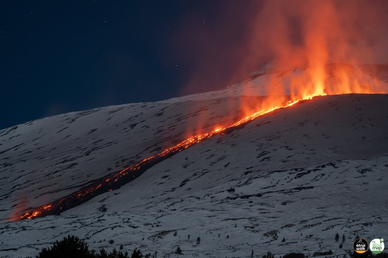
https://www.volcanodiscovery.com/etna/news/264885/Etna-volcano-Sicily-Italy-outpouring-lava-flows.html
Great! Fire and Ice, always great.
It can be a vision for what awaits us during next Grindavik eruption, but there with less steep slopes.
The interaction of lava and snow is not very explosive, it is different to the phreatomagmatic eruptions in a glacier. Lava probably only melts and vapours small amounts of snow along the immediate path, but doesn’t cause floods.
Hi Hector, sent you a small q under your comment from 2/11, 22.19
Interesting after the 4.9 at 08:29:51
Episode 9 at Kilauea is already over
The phoenix, “unica semper avis” (ever-singular bird), 1583
We are watching the Phoenix here. Everything comes back.
Re the shaking in Santorini:
Emergency declared on a second Greek island as a string of earthquakes persists (Phys.org, 12 Feb)
I haven’t seen anything about it from Santorini or Amorgos but one of the features of the Fentale dike event was a lot of cracking on the surface. Which can be fairly destructive when you have not especially well constructed buildings. On the other hand Fentale seems to be volcanic and this Santorini swarm tectonic, so maybe there’s not so much surface expression of what’s going on underneath.
My feeling is that this swarm is rifting, causing sinking along this fault. So more like Bardarbunga in 2014 or Kilauea in 2018. That would fit the long duration and the movement back and forth along the fault.
Why not. The active back-arc basins of the world were rifting and sometimes even asymmetric spreading can occur. The Aegean Sea is one of them:
Too small for a change. Nobody can see the Aegean Sea. Big version:
Concerning those big calderas that some scientists assume between 1. Amorgos and Thera and 2. between Kos and Nisyros I myself could not rule out that they had to do with water (all over the world). So I consulted the Messinian Salinity Crisis again. Refill too early, but it is possible that the refill took place at a slower pace for a long time at the end, and that those volcanoes were on about the same level as the sea. What water can do we saw in the eruption of HTHH and in many volcanic eruptions which might even have a low VEI with lahars.
https://www.volcanocafe.org/the-mediterranean-sea-salinity-crisis-salt-of-the-earth/
Eruption of Nevado del Ruiz, Colombia, 1985:
https://en.wikipedia.org/wiki/Armero_tragedy
It seems that water is more dangerous than lava, but is topped by a combination of water and dancing rocks. So, this Kolombo Volcano might not be a problem, but the resurgent dome in the Thera Caldera (also in the Toba Caldera or Crater Lake) might be one day, see Krakatoa.
Svartsengi/Iceland: If we look only at the valleys/peaks of each episode, we get a flat positive deformation of the minimum points, but since September 2024 a flat negative deformation of the maximum points. Since January 2024 the grade of deformation between the episodic eruptions has decreased. In January 2024 the Svartsengi GPS inflated by more than 200mm. In January 2025 it inflated by only 100m.
The statistical/mathematical development allows the prediction that the next episode probably starts at a lower inflation level than the previous one. We probably won’t reach the inflation level of November on Thorbjörn and Svartsengi GPS stations.
A good time to watch the webcams again, f.e. RUV’s Sýlingafell: https://www.youtube.com/watch?v=8bfcTBLvPiM
Active Fumaroles along the fissure.
In this video tw smoke puffs came out of the old crater (he missed the actual puff, but has them in the air):
– https://www.youtube.com/watch?v=QOWHpNu3H5g
I guess this is an indicating that it is about to happen very soon…
…the ground has started to breathe.
Pyromania videos of Etna and Kilauea:
https://www.youtube.com/watch?v=9F9xtE6IrGw
An Iceland volcanologist recently predicted the series of eruptions were coming to an end based on the slowing of re-inflation. Shaun Willsey wasn’t quite in agreement as he thinks it could still go on, just 4-6 months between eruptions.
Personally I think it will begin building up pressure to erupt somewhere else by next year, probably Brenninsteinfjoll or maybe further west.
Seems the Turks think this could be very bad.
https://www.emsc-csem.org/Files/event/1765158/Santoroni_Research_Report_English%20Version.pdf
From the paper
These guys have been amazing.
Defensive walls ready for any possible eruption (RÚV, 13 Feb)
I was watching live on one of the webcams during an earlier eruption when at 2 am Iceland time a whole bunch of them drove up, ran along the berm and rescued the earth moving machinery from the lava. They should get medals!
I just pray there is not an eruption inside the berm.
At Svartengi that is not likely. But at Grindavik it has already happened, so the possibility of that happening is already at 100%.
It would have to A) erupt in the right (wrong) place which it has only done once when the dyke hadn’t yet fully broken through/made the crust ductile, or B) the eruptive fissure would have to extend long enough to pass through the barrier, which would probably require no eruption for the next 4-6 weeks while it builds up enough magma. I think it’s probably safe for now as it keeps erupting on the same spot.
However Grindavik being safe-safe may be years away.
I’d expect that the next episode begins very soon. Inflation has reached the level at which it’s probable. So today or next few days it has to begin.
2024 also showed that since May Svartsengi has followed a rythm of ~3 months: May, August, November, February.
But if I look at deformation I have the impression that the eruption aims for a balance. Either it once changes towards a continuous eruption (f.e. low rate or lava lake) or becomes constantly “hot” dormant with continuing geothermal activity but without eruptions.
There has been a small swarm around Grabrok in Iceland. This appears to be part of the Losufjoll system.
https://flic.kr/p/2qLFHLP
It’s a bit further east from Grábrók. Grábrók sits right in the middle, almost exactly between today’s swarm and the persistent swarm at Grjótárvatn. For those of you who don’t know about it, Grábrók is an old cone right by the side of the main road if you’re driving between the southern and northern parts of Iceland. There’s a parking place and a trail up to the cone, so you can go up and walk around its rim. Worth a stop if you happen to pass by.
Thanks Tomas, I made a best guess, but I’m not quite as familiar with the Borgarsnes area.
//embedr.flickr.com/assets/client-code.js
Apologies mods, didn’t mean to spam.
Je ne sais pas embed pics
You can never embed Flickr I would say.
The Santorini swarm seems to be abating
I hope you’re right and that it’s not ‘stuck’ somehow, accumulating stress for a really big one…
As soon as the Research/Survey vessel AEGAEO arrived on site and started tracking inside the swarm area it quietened down!
You may have jinxed it 🙂
Origin Time
2025-02-14 14:57:40 (GMT)
University of Athens
Magnitude M 4.0
Latitude 36.5854° N
Longitude 25.6683° E
Focal Depth
10 km
# of Arrivals
78
Location 28.2 km NE of Thira
63.4 km SSE of Naxos
231.2 km SE of Athens
Solution type
automatic
A’a lava etna (Boris Behnke speaks Italian, but the images talk on their own): https://www.youtube.com/watch?v=eZjn8I1yYRc
Been reading these articles for years as someone who finds this sort of thing fascinating.
Amazed at the efforts put in to inform, educate and occasionally entertain
So thank you all.
Apropos of nothing- if you zoom in close enough on the usgs earthquake map the Aegean sea is apparently in the Pacific Ocean
Is it perhaps called the sea of america?
Hey… it is not so bad, as indeed they are both America, the Northern one is the United States. America is for all of them and was named after Amerigo Vespucci who was mostly in Brazil. Gulf of America is pronounced close to correctly by most people. Mexico is never pronounced correctly outside Spanish-speaking nations, so fine with me.
The problem is waiting though for the simple mind. If that mind hears Golf of America he might not know what it is. He might think It is Hudson Bay or – well – something like Cape Dorset Bird Sanctuary near Nunavut.
It is all on that notorious American Plate btw which has not moved one mile since 185 Ma. Time to give them some oceanic names maybe.
I got no dog in this, but I just refer to is as “The Gulf” (I live north of Houston).
But consider the Gulf of California and Baja California, which are entirely in Mexico…
So was California itself, once..
Not really, Albert. For 27 years only, with 40 different Mexican Presidents, very unstable. Before it was Spanish for 52 years, before uncountable tribes. Have studied some of their stories in the missions. Mostly fishermen. The missions were often good to them, live and let live. Lots of small tribes. The big tribes lived in and close to the Rockies in summer and took to the basins in winter. I wrote my paper for A-levels in English about “Bury my Heart at Wounded Knee.” It is heartbreaking, because they loved the country.
One cannot treat them like innocent or sort of holy, they had their mistakes. However their love for the country, the way they understood the countryside and dealt with it, is moving.
Did you ever realize that all those cute models of Pangaea or Rodinia or whatever in the Precambrian do not work with those large plates? And A.Wegener neither. Wonder when somebody will tackle that question. Maybe they have other things to do. It is important to note though that if some huge continents get to the conclusion that they own the possibly wrongly named plates, good old England/Avalonia will lose the cod. Take it easy. Russia will save them for once because no way will they cede Sibiria. Thank you for that enlightening piece.
All the current large continents are composed of many smaller ones…
Not sure where the link went…
…
I don’t know why the image didn’t want to show. The original image seemed to work better
Looks a lot more like random breakups and random crashes to me.
But then why expect anything different.
Entropy on a big scale?
Well, that is the craton, fascinating rocks, Methusalems. In the beginning, it was all rock. This is really missing in the Bible. HE must have said: “Be there be rock!”
But still, there was oceanic crust as well.
The craton, but minus the red stuff to be precise:
Another interesting paper
https://www.nature.com/articles/srep28013.pdf
Now on all local stations
Or if you prefer the more intense version
It reminds me of the spasmodic tremors that happen under Pahala.