
Humanity has a long history of living on this Earth. During the days and years, our world continuously changed. We grew up in the shadows of the approaching ice ages. We left Africa when the changing sea opened up a road to Asia, and followed an ever-changing coast line to the far East. And throughout our journey, we have been subject to the shakings and explosions of the Earth. Our footprints stand in the volcanic ash of the rift valley of East Africa. The massive Toba eruption left us a genetic deficit. The Minoan civilization suffered from Santorini, allowing Greece to begin its path to cultural dominance. And Santorini left us with the enduring legend of Atlantis. The restless Earth always was a powerful master of our fate.
The oldest depiction of an eruption is found in Turkey, in the ruins of Catalhöyük, showing the 9000 year old eruption of Hasan Dag, the twin-peaked mountain shown in the mural below. But art is not always easy to interpret, and there is an on-going discussion whether this image depicts a volcano or a giraffe. It would have helped to have a written explanation of what the artist intended. And that is the topic of this story, since we do in fact have a written document covering 2000 years of ancient history. And even if it was never written as a natural history, the stories in it contain echoes of the Earth. Hidden behind the pages is the miracle of plate tectonics.

Before we changed the world to suit us, people depended on the favours of nature. A good year meant life, a bad year could kill. Naturally, they saw gods in action in everything around them, and those gods were not benevolent. Sun gods especially abounded, but the Moon, planets and even trees also took part in the pantheon. Thor even took on the job of god of thunder. Human leaders would portray themselves as one of those gods, or at least as close relatives. Rameses provides an example: ‘meses’ is ‘son of’ and ‘Ra’ was the sun god. Secular France once had a sun king. It does make you wonder whether anything has really changed, seeing how France has seemingly acquired a new sun king. (Nowadays, the gods of business rank well above the gods of politics, of course. South Africa may not be the last country suffering state capture by the gods of business.)
Where volcanoes were obvious, they too became deified, the prime example being Pele, Hawaii’s goddess of fire. But there are not many volcano gods known around the world. The reason is that volcanoes are common only in a few parts of the world, and where they do exist, eruptions are often too far apart to leave a reputation. Even the Greeks, who have no lack of volcanoes in their own backyard, went abroad, to Etna, to find a home for the Greek volcano god.
In this landscape of the supernatural, there was one outlier. It also happens to be the one we know most about. The Jews started out within a world riddled with the supernatural. But over time, they became distinct from their neighbours, and began to ignore the gods of nature. They grew monotheistic, but more importantly, nowhere in their tradition is that single god associated with a heavenly or terrestrial body or location. It stood above the fray. It seems strange that this advanced philosophy developed in what for the most part was a fairly backward people, at times little more than slaves. They had no science, and little technology, apart from a brief period in their history early in the iron age. Their neighbours invariably were stronger and more advanced. But their way of thinking became superior.
And they left us some of the oldest story writings we know about. They are not the oldest known oral stories: the aborigines of Australia beat them to that by thousands of years, and even the fairy tales of Central Europe seem to date to 5000 years or more ago. Neither are they the oldest writings: the clay tablets of Mesopotamia are far older. But the bible gives us a uniquely human window into an ancient world between 4000 and 2000 years ago. It also contains the oldest written evidence of climate change, when in the 6th century BC Jeremiah asks: “Does the snow of Lebanon ever vanish from its rocky slopes?” Nowadays, there is little or no perennial snow on the Lebanese mountains.
But the plethora of stories are mainly about human lives. Right at the start is the ancient conflict of the Neolithic in the murderous relation between a farmer and a hunter gatherer, Cain and Abel. As the stories develop, we see how nomadic families become organised into tribes, and move from tents to houses. It tells of their attitudes, how the nomads of the semi-desert looked in envy and fear at the rich lands of agriculture, but without much understanding of their more advanced lives: all they hoped for was an abundance of milk and honey. Later the tribes become nations, and finally empires. The new city dwellers are shown to look down on the conservative pastoral people, whilst the farmers and herders of the countryside feel envious but uneasy about city life with its forgotten traditions and compromised morals. The stories are full of little details which otherwise we would know nothing about: people walking between parts of an animal sacrifice to seal a contract, or the strife of the herders to keep their flocks of sheep safe from lions. Some of the legends in Genesis are known to us also from Babylonian sources. Comparing the writings, the stories and characters are far more skilfully developed in the bible. The story of the bible gives us the human side, not the boastings of the Babylonian kings and the Egyptian pharaohs. It contains not just the successes, but also the failings of the main characters: the arrogance of Josef, the anger of Moses, the infidelity of David. No other ancient writing breathes so much life into its world.
Here, I want to look at one particular detail: how did the natural world of volcanoes and earthquakes shape the world described in the bible? It is not something the writers intended to talk about. But it is there, between the lines and behind the pages.
Location

From http://atlas.geo.cornell.edu/htmls/gsa_today.html
The story plays out in a vast area stretching from the Persian Gulf to Egypt, following what is now known as the Fertile Crescent. The eastern part of this may not look that fertile these days, with the desert landscapes of Iraq a common picture on our social media. Our news replays old conflicts: here lies ancient Babylon, in ruins, and the battles of Mosul raged where once was mighty Nineveh.
The fertile crescent follows the availability of water. The main rivers flow from Turkey, around Syria and into Iraq. The Mediterranean coast has rain, and it also has the Jordan river. Egypt has the Nile. The story of the bible moves between these habitable areas, avoiding the desert areas in between. But it also avoids the coast which was dominated by seafaring people.
The northern arc of the Fertile Crescent is one of the regions where agriculture developed. There are seven such regions in the world, but the majority of our crops originated in this one. This plays a role in the bible right from the beginning: the first story of the bible takes place in a garden, somewhere in the flood plain of the Euphrates and the Tigris.

Abraham’s journey along the Fertile Crescent
The story of Abraham’s travel shows him traveling up from the ancient city of Ur to Haran. Ur at the time was a coastal city, on the Persian Gulf. Haran is near Turkey. Both cities are on the Euphrates river. After Haran, the traveller turns south, along the Jordan valley, eventually reaching Egypt. It is notable that he stayed away from the Mediterranean coast, and went around the dry Arabian interior. The travel followed the Fertile Crescent accurately.
Tectonics
So how does this journey look in terms of the geology of the Middle East? The geological heritage is a rich one. And the tectonics is not bad either. Every type of plate boundary is present here. The Arabian peninsula is part of an ancient craton. The Red Sea is an oceanic spreading ridge which split this craton in two, starting from the triple point in Afar. It is pushing Arabia north, while at the same causing some rotation. The Dead Sea fault is a 900-km long transform fault, caused by this movement; parts have sunk to form a deep graben, hundreds of meters below sea level. (It is not a spreading fault, in spite of this sinking.) In the north, it connects to the Anatolian fault, which is a transform fault that runs through Turkey. Southwest of Turkey, in the sea, is a subduction zone, which has formed a volcanic arc in the Aegean Sea. To the east, the push from Arabia has caused a suture zone where continents collide: these are the Zagros and Bitlis sutures, a thrust-fold zone. The Zagros mountains also contain arc volcanoes, indicating this used to be a subduction zone, from an ocean that no longer exists. A forearc region has developed above the subduction zone: the subsidence formed the Persian Gulf and the lowland of Mesopotamia. Abraham followed this forearc, before turning south into the Dead Sea fault.

The Middle East has its fair share of earthquakes. The hot spots are in Turkey and Greece, but there also significant events along the Dead Sea fault. Flavius Josephus writes about a massive earthquake in 33 B.C., which he said (probably exaggerating) killed 50,000 people. Other devastating earthquakes happened in 363 (Galilee), 749 (Jordan Valley), 847 (Damascus), 1033 (Jericho), and 1202 (Southwest Syria). Since that time, things have been relative quiet, at least as far as large earthquakes are concerned. Medium-sized earthquakes (M6) have continued to happen, in 1837 in Lebanon, 1927 north of the Dead Sea, and in 1995 south of Aqaba. Although these were damaging, they were not as large as could have been. A major earthquake along the Israel/Jordan border seems long overdue.
There are other faults off the coast underneath the Mediterranean. In 551 AD, an M7.5 earthquake happened off the coast of Lebanon: the ensuing tsunami destroyed Tripoli, Beirut, and various other coastal cities. The 100-km thrust fault that was responsible has only recently been identified: each time it gave way, the coast rose up by 1 meter. The recurrence time appears to be around 1600 years. This fault is not ‘overdue’ yet but may becoming loaded. It is one to keep an eye on.
Other damaging tsunamis along the Mediterranean coast of Israel and Lebanon happened in 590 BC, 525 BC, 140 BC and 92 BC; 17 more tsunamis have occurred since, the most recent one in 1856 in Haifa.
The Levant is an area of tectonic complexity. The stories of the bible are set in this world. It would not be unexpected if the stirrings of the Earth are part of the backdrop. Let’s look, and not just at the tectonics but also volcanics. What is there – and what isn’t?
Earthquakes in the bible
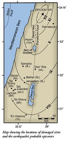
There are quite a few places in the bible which refer directly to earthquakes or which use the image of shaking ground. Clearly the concept was well known. The earthquake rate in Israel means that people would have felt something every few years, but significant damage would be a once-in-a-lifetime experience. The large majority of events are in the Dead Sea area. There is another cluster in Lebanon.

Earthquakes over the past 100 years. There is roughly an M4 earthquake every 5 years, and an M5 every 30 years or so. M6 may happen less than once a century.

There are four places in the bible where a specific earthquake is described, two of which refer to the same event.
By far the most memorable event was an earthquake which happened after Israel had split into two separate kingdoms. It happened during the reign of Uzziah in Jerusalem, and Jeroboam of the northern kingdom, in the period 781–742BC. (Uzziah is also known under a different name, Azariah.) The prophet Amos is said to have started his work ‘two years before the earthquake’ (Amos 1): this dates the earthquake to around 752BC. More than two centuries later, shortly after 520 BC, Zechariah writes (Zech 14) ‘you will flee just as you fled before the earthquake in the days of Uzziah king of Judah’ – the memory of that event ran deep! Even Flavius Josephus writes about, 800 years later, stating that it cracked the structure of Solomon’s temple and caused a landslide at the Mount of Olives in Jerusalem.
Source: Austin et al 2010, International Geology Review
There is archaeological evidence for the Amos earthquake, in the form of collapsed and dislodged walls and buildings. The debris is in a layer just below that of the extensive destruction done by the Assyrians after 730 BC which brought an end to the Northern Kingdom. The earthquake damage is most severe in excavation sites to the north. Hazor, in the north of Israel, shows the worst damage. Mud brick constructions at Deir ‘Alla (weaker than the stone walls of Hazor) showed a general collapse. The book of Amos also talks about severe damage to the buildings at Samaria and Bethel. In Jerusalem, Solomon’s Temple cracked (Josephus), and the population panicked and fled (Zechariah). At Gezer, northwest of the Dead Sea, heavy stones were displaced from their foundations. West of the Dead Sea there was significant rebuilding to four southern cities (Tel ‘Erany, Lachish, Tell Judeideh, and Tel Sheva). South of the Dead Sea at ‘En Haseva, damage was not as severe. The pattern indicates an epicentre in the north of Israel or southern Lebanon. The size is of course not well known, but it has been claimed to be as high as M7.8, well in excess of the quake of 1202 in this area. Austin even argues that it exceeded M8, because of the widespread damage, but this seems over the top.
The earthquake had an immense impact on Israel. The book of Amos is full of references to earthquake damage, from the shaking earth to the cracked altar. Some 20 years later, the first Isaiah uses similar language and from that point the image of a shaking earth becomes a common feature in the writings of the prophets. The memory of this massive earthquake remained vivid for a long time. But it was worse than that. Before the earthquake, the northern kingdom was at the height of its powers. 30 years after the event, it was gone. Only the weaker southern kingdom, further from the epicentre, survived. Did the earthquake ruin the northern kingdom change history? That is certainly possible: Portugal was economically ruined by the Lisbon quake and never fully recovered. History tends to read like a collection of accidents, and this was one of those accidents. We will never know what could have happened.
Other earthquakes
Two other earthquakes are specifically mentioned in the bible. I Samuel 14 tells a story of a battle between Israel’s tribes led by Saul and the Philistines, the rather more powerful people living at the coast whom the Egyptians called ‘the Sea Peoples’. This will have been around 1040 BC. An earthquake caused panic in both armies, although it does not appear that it did much damage. Tents are not as susceptible to earthquakes as houses are: as civilizations develop, they become more fragile.
The final earthquake happens late in the bible, in Acts 16, when Paul is in prison in Philippi, and the prison was badly damaged in an earthquake. Philippi is a coastal city in Macedonia, just north of Greece. This is a zone of frequent earthquakes, and the city became partly destroyed by them in the 7th century. Paul’s earthquake around 50 AD does not appear out of the ordinary: even last week there were two M4’s in the area.
There are other generic references involving earthquakes, many in the psalms. The most notable one is when Elijah flees into the desert: “Then a great and powerful wind tore the mountains apart and shattered the rocks before the Lord, but the Lord was not in the wind. After the wind there was an earthquake, but the Lord was not in the earthquake. After the earthquake came a fire, but the Lord was not in the fire. And after the fire came a gentle whisper. When Elijah heard it, he pulled his cloak over his face and went out.” This is a typical Jewish story, which make the point that, unlike the neighbours, their god is not a god of earth or fire.
The Jordan River

The Jordan river
There is one story that does not mention an earthquake, but implies one. It is when Joshua first enters the new land by crossing the Jordan river. The Jordan river was perhaps half a mile wide at that time, and difficult to ford during the rainy season. Nowadays, the Jordan has lost 90% of its water and is only a shadow of itself. The river would have been a far more difficult barrier than it appears at the moment, at least in flood. The text in Joshua states: “Now the Jordan is at flood stage all during harvest. Yet as soon as the priests who carried the ark reached the Jordan and their feet touched the water’s edge, the water from upstream stopped flowing. It piled up in a heap a great distance away, at a town called Adam in the vicinity of Zarethan, while the water flowing down to the Sea of the Arabah (that is, the Dead Sea) was completely cut off. So the people crossed over opposite Jericho. The priests who carried the ark of the covenant of the Lord stopped in the middle of the Jordan and stood on dry ground, while all Israel passed by until the whole nation had completed the crossing on dry ground.”
There is a geological background to the strange-sounding story. The steep western escarpment of the Jordan valley is prone to collapses, normally earthquake-induced. These happen mainly opposite the Zarqa River (called the ‘Jabbok in the bible), some 50 km north of the Dead Sea. This is approximately where the town called ‘Adam’ is thought to have been (the name still occurs in that vicinity, as Tell Damiyeh.) After such a collapse, the Jordan tends to become dammed by the land slides. These events are not uncommon: there are at least six references to the Jordan River being dammed since the 12th century AD, sometimes for several days, due to landslides caused by earthquakes; in 1160, 1267, 1534 or 1546/47 (for two days), 1834, 1906 (for ten hours) and 1927 (twenty hours). The text about the Jordan crossing refers to such an event, and the detail in the description shows that the narrator was familiar with the cause.
Shortly after the crossing, the narrative moves on to the destruction of Jericho, with its collapsing walls. It depicts a politician’s paradise, where Joshua only needs to walk around the city seven times and play some music before the city falls. In other words, skirt the issue seven times, make some noise, and it will go away. Jericho is an archaeological quagmire. It is a very ancient city, with various ups and downs. Whether one of those downs coincide with Joshua’s conquest is disputed. The biblical chronology puts the conquest of Canaan at around 1400 BC. There is evidence for a destruction of Jericho at that time. But cultural and archaeological evidence puts the conquest of Canaan later, around 1200 BC, and Jericho was unscathed at that time. The story of Joshua’s conquest in fact only lists places in a very small, mountainous region, and it may therefore represent an initial incursion, with the main expansion happening much later. This is the most obvious way to reconcile the chronology and the archaeology. Relevant for us is that Jericho was in an earthquake zone and its walls were always in danger. But the narrative does not mention an earthquake. One can speculate that an earthquake had happened earlier and had left the city defenceless, but that is not part of the written story.
The Jordan rift valley is prone to major earthquakes. The casual way they are described shows that people were familiar with them, but they still could cause panic and chaos.
Tsunamis
To disappoint the reader, there are no direct mentions of tsunamis in the bible. This may seem surprising, in view of the frequency of tsunamis in the region. But the Jews lived mainly in-land, in the more mountainous regions. Even Abraham, traveling far and wide in the area, followed the Jordan Valley and avoided the coast. Other peoples lived on the coast. The shortage of biblical tsunamis stems from this location.

There are two stories worth looking at. The first is Moses crossing the Reed Sea, where water first goes out to create a place to ford, and on return drowns a following army. Various proposals have been made that it was caused by a volcano-induced tsunami (Ian Stewart) or an undersea landslide (Abril and Periáñez). But the story itself attributes the disappearing water to wind. The precise location is bimodal: various translations give it as the ‘Red Sea’ or as the ‘Reed Sea’: these two are on opposite ends of the Sinai and on different oceans.
The water was driven out by an easterly wind, according to the narrator. This argues against the Red Sea, as there an easterly wind would sweep the water in, not out. It could work around the Reed Sea, in the Nile delta. Carl Drews ran simulation and found that that a coastal lagoon near Port Said could have been evacuated by such a easterly storm-force wind. No tsunami or volcano is needed.
The second story is that of Noah and the great flood. This is not originally a Jewish story: it closely follows the Babylonian Epic of Gilgamesh, and it takes place not in Israel but in Mesopotamia. The biblical narrative seems to be based on two separate sources which differ in some details: the two have been skilfully merged but the differences have been left in. An interesting detail is the role of wine and vineyards: wine growing originated around Georgia, south of the Caucasus, as early as 6000 BC. This agrees with a Mesopotamian origin. The Gilgamesh dates from 2000 to 3000 BC: the flood story has ancient roots. However, there is no clear single event that can be identified as the source.
Floods are very destructive and leave long memories. For instance, the Australian Aborigines have stories about the coastal plains, which were flooded 10,000 years ago as the sea levels rose after the ice age. The Mesopotamian story could similarly relate to an actual extreme flood along the river plains. A major flood happened around 3000 BC when the Tigris had become dammed by a dune field, and finally broke through. Highly controversially is the suggestion that the story relates to a flooding of the Black Sea. The story could even relate to the flooding of the Persian Gulf after the ice age, which caused significant relocation of settlements around 5000 BC.
Amidst all these possibilities, tsunamis play no role in either story. The Israelites had little experience with tsunamis, living neither on the coast nor along flood-prone rivers. their neighbours suffered more, but they did not leave records. We only have the in-land record of the bible.
So far for earthquakes and tsunamis in the world of the bible. Part II will consider its volcanoes.
Albert Zijlstra, April 2018

Jerusalem – history in an earthquake zone


As far as I know, the MMI scale goes up to ten (X). MMI XII would be unlike anything I’ve ever heard of. Ground acceleration over 7 g? Frightening.
It goes up to 12. But I think that the numbers are over the top, as the post mentioned. They come from the paper that put the magnitude at 8.2, whereas others put it at 7.8. That is a big difference.
https://www.gns.cri.nz/Home/Learning/Science-Topics/Earthquakes/Monitoring-Earthquakes/Other-earthquake-questions/What-is-the-difference-between-Magnitude-and-Intensity/The-Modified-Mercalli-Intensity-Scale
Still… at 7g+, that would probably take down modern structures.
It would. But the MMI scale does not correlate with ground acceleration above MMI VII or so. Above that, it scales better with peak velocity. Still, and XII stones are thrown up into the air, so the acceleration exceeds 1 g.
I get a peak velocity (PGV) of 5.228 m/s at MMI-XII.
At MMI-IX I show PGA of 0.966 g.
Remember even the M9.5 1960 quake was MMI XI, so even a quake that was almost the highest physically possible magnitude didn’t get the highest rating!
By the way, Piton is erupting again
Something I have noticed about piton de la fournaise is that it seems to switch which side of the central vent it erupts from. Last eruption was on the north side, this is on the south. It also seems like there really wasn’t much magma involved in the last eruption at all, or this eruption wouldn’t have happened. Also the notable complete lack of eruptions in its central crater since 2010.
Maybe a powerful shallow earthquake would produce a stronger ground vibration. Transform fault earthquakes could happen near the surface, basically at the surface if the fault is visible like the san andreas. Subduction earthquakes are always sort of deep because subduction zones are deep structures, even if they are much bigger than anything you can get on a transform fault.
Both of these are beyond dwarfed by the earthquakes caused by large asteroid or comet impacts, but if an asteroid big enough to do that bits the earth there are probably other things to worry about, like a mass extinction :I …
In the remote chance I am not moderated (why?)
Please note that as far as I can see there is no reason why you could not have an M11.0 quake, although that would likely be biblical.
GL Edit: Yeah, you were. Dunno why either. (I’m on late watch.)
As for an M11.0…. {eek!}
For a strike-slip;
Subsurface rupture length → 17782.79 km
Average Displacement → 3801.89 meters
Down-dip rupture width (km) → 162.18 km
Peak Ground Velocity → 413.410 m/s
Mostly based on calculations using Wells-Coopersmith’s “New Empirical Relationships among Magnitude, Rupture Length, Rupture Width, Rupture Area, and Surface Displacement” and Atkinson-Wald’s “Did you feel it?” paper (PGV data)
Note: According to Wells-Coppersmith → “Reverse-Slip relationships are not significant at a 95% probability level” but, I specifically used strike-slip calculations.
Also Note that the PGV value is dubious since my calculations simply apply the formulas. Those formula are designed for a specific range of magnitudes that they were fitted to… anything outside of that range is VERY PRONE to erroneous results. Remember a sacred rule of thumb… a fitted formula is only valid for the range that it was fitted to. Example: A formula that has a dominant square function will take off towards infinity either negative or positive depending on the nature of the data it is fitted to any time you go outside the data range. Why? A function that has a dominant square feature is essentially a parabola, and a parabola’s nature is to do that as you move more negative or positive along the x-axis. Cubic functions are similar, but each end takes off towards infinity in different directions (both negative and positive) as you move away from the fitted region. This is an inherent “feature” of fitted polynomials… also why you should be careful with any auto fit routine. The fitted poly is only good for the range of data it was fitted to and has minimal predictive value the further outside that range you go. About all you can do is infer what may be out there, but until you see it, and can add that to the curve fit, it’s pretty much worthless.
Another note: There are other mods here with far better math skills than I. If I am wrong, you can rest assured that one will smack me about the head and correct my statements.
Note: If this is new to you, don’t sweat it. I passed Calc 101 twice and it still eluded me until I was exploring Hurricane Categories to Wind Speed values a few years ago and had to re-learn what polynomial fits meant.
Why did I take Calc 101 twice? Late transcript issues. I was pretty much finished passing it the second time when my transcript showed up. The second go at it essentially turned into a refresher course and I got stuck with the original grade.
BTW… if you are a middle or early High School student and math is kicking your arse… grit yer teeth and bear it. If you get a chance to take Analytic Geometry, JUMP ON IT. In Analytic Geometry, you see how all that arcane knowledge can be useful. That was where I learned my first practical use for math. If you eventually go into a physics feild, you’ll be ahead of the game if you have applicable math skills. Sure, you may never get a chance to use it, but if you can take away some measure of skill from it, a lot of the information in some of these papers (geological and other wise) become a lot easier to grasp. For example, the calculations above are simply an application of their formulas into a spreadsheet with some potential variables piped into them to see what comes out. Physics not your thing? Quantitative analysis is used in the realm of finance (Stocks-Bonds) and “Quants” command a pretty hefty salary for their work.
As for the various papers, granted, the Wells-Coopersmith one was a bit complex, but with determination and care, I got my implementation in the spreadsheet to match their sample data. Since most of my results closely match what USGS later puts out about quake events, I’m pretty confident that my implementation is accurate. As for the fictitious Mag 11.0 stuff, I’ve already noted the potential for error there. Take that with a grain of salt.
As for my spreadsheet skills, I got bored on watch while underway and from hammering away at the spreadsheet program, became fairly adept at using it. Later, on the same cruise, I got tasked with a bizarre function of “Data Fusion” and wound up taking time based events from the logs of several watch-stations in CIC and merging them together into one seamless event log for a post exercise briefing. Needless to say, the command was quite happy with my effort. I later did something similar for a NATO command we were attached to and they were equally pleased with my results.
It’s just a matter of applying stuff you’ve learned. Sure, this is just the rambling of an aging retired Sailor, but you reap what you sew. That’s a rule you can’t escape.
There isn’t a subduction zone long enough to create a magnitude 11 earthquake. The scale used now (which isn’t the Richter scale) goes up on an exponential scale and to create a magnitude 11 earthquake would require a fault line longer than the earths circumference. A 10 km wide potentially metallic object moving at 50,000 km/h would probably do it though, and a block of ice moving at >200,000 km/h would likely be higher still ( and yes comets actually move that fast). If hale bopp (60 km wide) hit the earth in 1998 the damage would have been beyond what the word apocalyptic can describe…
Magnitude 27 ‘earth’quakes can happen on magnetars though, which are highly magnetic neutron stars. They would release enough energy to turn the entire earth into its component atoms and throw them at galactic escape velocity…….!
Earthquakes are physically limited to about M9.7
On Earth it would be hard to see how anything can exceed that. It is effectively the length of the rupture times the amount of slippage, and the size is limited by the longest fault segment we have (the one around Indonesia is not far off that) and the strength of the rock. Big asteroid impacts could exceed it in terms of energy but the scale hardly applies to those (and impacts is another post, one day). The Mercali scale is different as it is based purely on how we experience a quake and that depends a.o. on the kind of surface. MMI 12 (flying rocks) could in theory happen from an M7 quake if you are in just the wrong place.
I cant remember what I read this from, but I remember reading that an eruption of 1000 km3 of magma is equivalent to just under a magnitude 9 earthquake, so earthquakes actually release WAY more energy than volcanoes do. The 2004 boxing day earthquake released more energy than the toba eruption…
The same scale listed the tsar bomba as being equivalent to a magnitude 8.5 earthquake, which I guess would make the tsar bomba at least a VEI 6 as a volcanic eruption, in terms of total energy, which makes sense for something that was able to create the only known case of a mesospheric mushroom cloud.
In 2005 a magnetar 50,000 lightyears from the earth underwent a starquake. The event released the same energy in 0.1 seconds that the sun does in 150,000 years. It was also the most energetic event in the galaxy since the 1604 supernova.
If it was an earthquake, it would have been a magnitude 29 event.
This star was literally twice as far from our solar system as the center of our galaxy, if the star did this from from the same distance sirius is from the sun (8 lightyears) it would have been equivalent to a 12 kiloton nuclear bomb at only a few km distance, essentially the hiroshima bomb but over the entire side of the earth facing the star at that time… In a previous comment I said that it would have been enough energy to completely atomise the earth and send each atom at galactic escape velocity, but after reading a bit about the event I think it could atomise the entire solar system, including the sun…
Where exactly is the longest subduction fault on Earth? If it’s Indonesia, where exactly?
Sunda Trench. But South America has a really long one also. Dunno if it’s capable as operating as one full unit.
The magnetar released around 10^40 J in that outburst. To unbind the Earth requires 2 times10^32 J. But the energy generated by the sun over one year would also be enough for that. To unbind the Sun requires more than 10^41 J so the magnetar could not have done that. There are much more energetic events in space. A supernova will generate 100,000 times as much as that magnetar did.
The Indonesian subduction fault is 5000 km long. I think the one along Chile is a tad longer but not much.
I wonder if bigger earthquakes could happen on super earths. Even if terrestrial planets bigger than 2 earth masses are unlikely to have plate tectonics, their internal heat has to go somewhere so when it breaks the crust some pretty big quakes could happen.
Theoretically it is possible for terrestrial planets to have masses of several jupiters if they form around a massive star that blows away the lighter material in the protoplanetary disk.
The reason we haven’t seen any of those is probably because those sort of stars tend to go supernova…
Caveat Emptor
Well.. I’m a happy camper. My Urologist called me today and said that based on my most recent blood tests, I am cancer free. Yay!… (but it cost me an organ.)
Great news lurk!
Excellent news!
Fantastic! I am very glad to hear that.
Don’t feel bad about loosing an organ….. eventually we loooooose everything…. and some don’t even have everything to begin with…. Find Joy…. Best!motsfo
Good to hear😊
That’s great news! 🙂
Oraefajokull in Iceland seems to be clearly heading for an eruption.
Oraefajokull had the largest explosive eruption in Iceland in the past 1000 years, a short lived VEI6 in 1362.
A silent volcano two years ago, has been experiencing a progression of earthquakes that is typical of a run-up to an eruption.
I predict an eruption a few months to a few years from now. This is only an educated guess. I expect strong swarms a few weeks before the start of an eruption.
I could write a post about it.
Certainly Oraefajokull deserves a post now.
I second this, always like a good Iceland article, and things seem to heading towards an eruption at at least 5 volcanoes within the next decade.
If no eruptions happen within the next year I will be surprised, and if nothing happens by 2020 then that might border on a black swan.
Technically, per Talebs definition, actual Black Swans are profound in their effects when they occur. By not happening, that would be more towards the “Hmm.. that’s odd” level of catastrophe. In other words, not much of one.
True, maybe black swan is the wrong term, but I still hold by my prediction, if we get to 2020 then that is just shy of 5 years without an eruption – not exceptional but probably unusual given the increasingly active state of the hotspot this century. From what I have read about bardarbunga it seems like most of it’s rifting events involve multiple significant eruptions, at least something capable of breaching the glacier, why that didn’t happen at holuhraun is interesting.
I’m honestly a bit surprised that there hasn’t already been an eruption somewhere since holuhraun ended, I thought at least katla would have broken by now, maybe it’s ‘planning’ for something bigger…
Also on the subject of black swans, I have honestly never seen a white swan in the wild before, all our swans are black 😉
That was a point mentioned by Taleb in his book on the phenomenon. Around here we don’t even get that. Mostly buzzards and crows.
And flying rats. (Aka “seagulls”)
I hope you do. I’d like to read more about Oraefajokull.
I recall the max magnitude lies around 15.
Around that point the energy released surpasses the amount needed to blow up the earth
Good job that can’t happen in reality or we would be toast lol
My previous comment will be helpful then 😉
Snowstorm on a comet
https://youtu.be/zcXUawPhhJw
The same clip runs three times, at different speeds. The regular moving dots in the background are stars. The others are small bits coming off the comet, and flying past the spacecraft
i read the Lurk’s math explainations to darling hubby and he totally enjoyed it… even commented “Excellent”.
GL Edit: “Thank You”
Surprised you didn’t include the volcano depiction from Chauvet, estimated at 36.000 years old https://www.nature.com/news/cave-of-forgotten-dreams-may-hold-earliest-painting-of-volcanic-eruption-1.19177
Yes, I should have mentioned that one. It escaped my memory. It is very similar to the case from Turkey, apart from being four times as old: it is plausible that it shows the volcano but not proven. Thanks.
The plot is thickening again at Pu’u’o’o . Since yesterday the crater has expanded by 2cm, which is a lot. The tilt has not changed though. Kilauea is in DI mode and quiet. But Pu’u’o’o is not.
Interesting. What do people make of those waveforms? They look… odd. Not like normal quakes. Pretty symmetrical; they start, rise to a peak, then fall off.
Now I’d normally associate that kind of symmetrical signal with human activity – people or vehicles approaching the instrument location, passing it at the closest point, then receding again. But there shouldn’t be anything of that nature anywhere near Pu’u’o’o!
Could it be a helicopter?
Intriguing and distinctly possible; since it’s outside the boundaries of the national park, helicopters can and do fly over Pu’u’o’o – I’ve done so myself.
https://www.youtube.com/watch?v=uatU3Z5CTCA
This is a video taken by someone who was lucky enough to be above pu’u o’o on August 3rd 2011 when that breakout happened. The lava flowed fast enough that it was visibly incandescent in daylight. When you realise how big pu’u o’o actually is then it puts this into perspective, clearly not all lava flows move slowly enough to walk away from, even on flat ground, over 1 km in only a few minutes…!
Maybe someone will get the next breakout on camera this way too.
I would expect a similar scenario as this during the next breakout, only the next one is more likely on the north east side of pu’u o’o and might be even bigger. Its technically not a flood basalt, but it is definitely a flood of lava, and unlike the august 2011 breakout, the impending one has also got an almost full lava lake at halemaumau to drain in addition to a similar amount of magma under pu’u o’o.
Our family also did this, they will circle the vent several times trying to get you a look at a flow or a window to some running lava. We were lucky and did see a window and some running lava at the bottom of the hill.
It is interesting that the tiltmeter records have levelled off for pu’u o’o over the last day, but the gps shows continued rapid inflation. Maybe the tiltmeters are on a part that has started very slowly falling into the crater, and is coincidently falling at the same rate as the inflation? Whatever the cause is, it appears the tiltmeters are no longer being ’tilted’, but the gps is still recording the same rate of deformation as before.
At least for a few more days though it looks like the show at the summit is over, though the lava lake probably only looks deep because of how thick the overflows from the last week are. If pu’u o’o breaks then the pressure will be released and the lake will probably sink down a lot more though.
In the early 19th century reportedly the entire floor of the caldera was a lava lake… A single body of lava that was probably over 2 km wide, that is a genuine lava lake if there was any real definition. It also filled in the caldera at a rate where the caldera was filled in by about 200 meters between 1790 and 1823. In 1790 the caldera floor was below the water table or there wouldn’t have been an explosion, so things must have really been busy over that time. Seems like the original lava lake started with a bang too, just a much bigger one than the tiny explosion in 2008 (GVP lists the 1790 eruption as a VEI 4, which is impressive for a ‘safe and quiet’ volcano…).
Tomas has got his next northern Bard plug quake 😊
Not large enough. Expect more to come… 🙂
why?
would you be so kind to elaborate for me please
Bardarbunga recently had a dike of magma travel out from it and take a hard left turn just north of Grimsvotn’s chamber, then trek out to the North East along the Grimsvotn fissure swarm and eventually erupt at Holuhraun. As that eruption progressed, many noted quakes at Bardarbunga that seemed to match a drop in the crater floor… essentially additional slow caldera formation as the Bardarbunga chamber emptied. Albert (mainly) had an idea of about when Holuraun would stop eruption based on a gravity flow model as Bardarbunga emptied. The quakes there nicely lined up with the ring-faulting as the plug settled. Since Bardarbunga almost (not quite) sits directly on the plume head for the Icelandic hot-spot, it’s refill rate should be higher than the other volcanoes. As it refills, the stresses pulling down on the Bardarbunga crater floor lessen. The quake activity is a combination of crater floor readjustment and infill activity.
Look at this graph. It has been flat for a while now. If we assume that the energy release continues at the same rate as lately, then there is about an M5 “missing” to bring the curve up to an imagined extrapolated straight line.
http://hraun.vedur.is/ja/Bardarb/bb_lib_mag.html
Mauna Loa wants a word. No idea what it is trying to say – it seems to have stopped inflating.
The Pu’u’o’o seismograph does not show anything notable this morning. If it indeed was helicopter noise, that makes sense as the weather seem to be atrocious down there, and not suitable for safe flying.
The unrest at Mauna Loa seems to be coming to an end, everything has dropped to pre-2014 levels. If trend continues, the alert level could soon go back to green. There has to be a lot of magma built up by now, it has had about 12 years of inflation in total since the last eruption!! I have a feeling it could be heading for a 1950 again. The summit region has to be very strained by now!
Re; Mauna Loa. That’s the bad thing about a volcano that erupts every thirty years or so when you’re spoiled by a volcano next door that’s erupted for thirty years…
I wonder where 1950 came from. For 125 years or so, there was nothing about SWRZ eruptions that indicated a huge eruption was in the cards. Or about any ML eruption, for that matter. 1859 and 1877 were anomalies based on location, and 1868 based on chemistry, but every other eruption–summit or rifts–had the same chemistry. There was nothing strange about the composition of the 1950 magma, and the change in chemistry fell within parameters as the eruption progressed. 1975 and 1984, as well.
So it wasn’t a slug of new magma, similar to what happened at Kilauea in 1959. Also, if 350m cu meters doesn’t cause a summit collapse, what does? There wasn’t even a hint of a collapse.
Strange, to be sure.
It is notable that when mauna loa last went through a period of unrest in 2002 that when it stopped inflating, a new big lava flow started at pu’u o’o, which was later called the mothers day flow. Apparently it started in a very similar way to the august 2011 flow, but for some reason there are no pictures of the event at all until 2 weeks after it started when it was more like a normal slow moving lava flow. It also started after a situation that is extremely similar to the current situation (previous flow active for 5 years starts dying out beyond 2 km from the vent, inflation at the summit and at pu’u o’o, long term inflation ends at mauna loa)…
So mauna loa hasnt had any true eruptions since 1984, but the current activity might be considered as a sort of ‘phantom eruption’ caused n part by mauna loa being inflated and pushing against kilauea.
Still though, I cant see mauna loa getting more than 10 years before it erupts for real, the fact that kilauea was erupting already didnt stop it erupting in 1984, or in 1919.
That 350 m³ (?) of magma causing a collapse depends on chamber depth.
“Caldera formation by magma withdrawal from areservoir beneath a volcanic edifice” by Pinel and Jaupart — Earth and Planetary Science Letters 230 (2005) 273– 287, goes into a lot of details about edifice stress loading and the conditions that cause a collapse. It’s a great paper if you can track it down. I haven’t been able to derive any spreadsheet tricks from it yet… but it’s something I have been wanting to revisit.
Gut feel… but 350 m³ seems a bit small to be concerned about a collapse. 350 km³ it would quite likely to cause a collapse… but at that level, you’re talking about serious damage to the summit… if not the whole mountain… but, it still depends on chamber depth.
D’oh! Km. I knew it looked funny when I typed it! Thanks!
I assume it meant 0.35 km3. 350 m3 is 0.00000035 km3.
I read somewhere that the 1950 eruption started after less than a day of warning too, it was an expected event because of a summit eruption the previous year, but apparently magma ascended from the deep chamber to the shallow summit chamber and erupted in less than a day, and then propagated down the rift zone to end up at the final vent location in only 3 days.
The area covered by lava flows in 1950 was actually bigger than holuhraun, despite the eruption being much smaller and lasting 1/8th as long.
Also the small lava lake at pu’u o’o is on the verge of overflowing the pit that it is in. It might have already done it by now actually.
I’m surprised nothing has happened by now, the gps readings are over double that of anything that has happened in at least the past 5 years. If there is an archive of deformation graphs available it would be very useful, but my guess is that even the 2011 events would be eclipsed by these recent readings. Normally I think that the total ban on walking into the reserve near pu’u o’o is a bit extreme, if there is an open vent on the other side then there is no risk of overflows or breakouts, but right now it is very sensible, to say the least…
Stained too if someone is standing there when it all goes active.
So Mauna Loa is not (yet) bubbling, but babbling?
Increasingly so. Although I do not know what it is trying to say
Where is this seismometer located? If it is in the caldera then I really can’t think of anything other than something volcanic being the cause. If it is on the lower flanks though it could be a lot of things, like construction or traffic.
If it is near kilauea it is probably artificial as there is surprisingly a lot of residential and commercial centres around kilauea’s summit, including a golf course and what looks like a retirement village on google earth…
Maybe there is a storm nearby? Apparently Hilo is one of the wettest cities on earth with rain 4/5 days of the year, so this could be it.
Of course it could be the run up to an eruption…
MOKD is on the northern rim of the crater of Mauna Loa. Construction and traffic noise should not be too bad there! Wind and weather will have an effect.
So that leaves only weather or an impending eruption… Its probably weather but I dont know how to tell which quakes are external and which ones are volcanic so…
I’m guessing that harmonic tremor is continuous for long periods though, and this doesn’t look like that.
Lets have a vote on iceland volcano erupt first. I think katla is going to blow this year vei 6.
This was spam listed because of a problem with the email address that was supplied. Admin
I’d go with Hekla, myself!
I would say either bardarbunga or grimsvotn, with oraefajokull a close 3rd given the recent activity. Hekla is too unpredictable to say it is likely to be the next eruption.
Katla seems to not be changing enough to indicate any sort of eruption, and even if it goes really big it wont reach VEI 6 unless it has a repeat of eldgja, which is not likely. Katla is not a subglacial pinatubo like the media thinks.
Why are katla silent? It has Been like this since the 4.5 in october. Is the charging and inflasion all ended. All the big eq in barda , are they effecting grim and ørea since they are so close and in the same glacier?
Katla like to sleep during the winter, she’ll soon wake up as the weather warms up or she gets another intrusion.
The last one, 3.9 isn’t big for Bardy and it certainly wouldn’t affect the others at that magnitude. Oreo is too far away to be influenced by Bardy and Grims.
There is another blue circle added to the pu’u o’o gps readings. If one circle is added every day, then it has taken only 4 days to double the reading it said before… The tiltmeters aren’t showing anything, but the tiltmeters aren’t actually on the crater floor either, they are on the relatively stable north edge. At this rate next Monday would show twice the amount of inflation that is there now…
Maybe there are no easy breakout spots now (somehow) so the magma is just going to build up until it breaks through.
My guess is that on May 4th (because Star Wars day…) there will be from a fissure extending from the location of the June 27 vent area down the flanks of pu’u o’o roughly parallel to the episode 58 fissure, and ending on the flat lava field about 2 km northeast of pu’u o’o, going quite close to one of the webcams. This flow would probably be a lot more vigorous than the start of the June 27 or 61g flows and depending on how deep the connection is there might be some lava fountaining too which would be very visible at night on the webcams. The lava would likely reach the forest within hours as channelised a’a flows, though it would probably stop advancing soon afterwards. The lowest vent would be about 80 meters below the top of pu’u o’o and would drain out the crater leading to a collapse like what happened in 2007 and 2011. This vent would keep erupting as it is the lowest point. The lava flow would go mostly north and a bit east into the forest and probably eventually into inhabited areas.
A bit doom and gloom at the end but nature doesn’t care if your house is there or not really, you could just build a thick concrete wall around it and that would likely stop all but the biggest flows, and you would get a lava castle 🙂
If this actually happens and HVO don’t call it the Star Wars day flow, I will be disappointed lol
Surround your house with these and you should have a good solid lava-proof wall, and if it is unnecessary in the end, then you now have a combined castle and nuclear bunker for when times get rough 😉
Or of it doesnt work then your house can confuse geologists in 4 million years when concrete starts eroding out of a cliff…
I know lava flows, particularly pahoehoe sheet flows, can inflate over time, but there is no confining topography in northern puna for the flow to become channeled in, so if the lava even manages to get there it will just spread out around any heavy structures that are there and probably not inflate more than a few meters. It wouldnt be like the flows that covered Kalapana in 1990, because Kalapana was in a shallow graben formed over the past 1000 years of subsidence (it isnt anymore of course), which shows that lava hadn’t been there in a long time. Those flows were also about twice as close to the source vent as what any flow in an inhabited area north of the rift zone would be, and were fed with a higher average effusion rate than flows now. If the June 27 flow had the flow rate of the 1990 flows, Pahoa wouldn’t be there anymore.
Given that the June 27 flow got about 24 km, that is about what could be expected of another flow that goes north of pu’u o’o, it might go further but probably not beyond 30 km.
Just checked the tilt and Kīlauea has started a DI change to inflation. My guess is that the 3.2 quake we had the other day might have made some room for some of Kilauea’s magma to drain out and fill a void. Maybe when the void is full we might get back to the high levels we saw last week. Just a guess.
Mac
Looks like Pu’u O’o has started something… The inflation has spiked 40 micro rad in the last 15 mins or so. Don’t see anything on the webcams yet
All three of the seismographs around the Pu’u O’o show some noise starting at around 00:15 UTC
I may be imagining things but it looks like there is spatter in the vog. I thought it might be dirt on the lens but they seem to be moving radially away from the centre of the image.
Looking at an updated image, the webcam will probably be destroyed soon. Those lumps are too close.
I see what you mean, but looking at the thermal cam I don’t see any hot bits in view (although something might be going on in the background). Maybe dirt/water/bugs that we’re seeing?
At least for the moment, the tilt graphs have been brutally re-scaled so it looks like there’s been no deformation at all for the past week!
2.5, 2.8 and 2.2 quakes SE of Pu’u O’o. Noise on the seismograph is still rising. Weather is nasty and that can play a part. Kīlauea’s tilt has a major change, maybe the rain or not reporting?
PAUD Seismograph is going nuts along with KNHD, even showing along the coast on KAED.
Crater thermal’s lit up like the surface of the Sun,..
The thermal is high because when it is foggy the sensor reads hot as slightly above the ambient temperature, so it isnt really actually that hot. Even if the crater completely collapses I dont think the air around the camera will heat up to 400C+ temperatures, there is a thermal cam above the 1150C lava lake in halemaumau that is showing clear images after all.
That being said the seismometers are showing a lot of activity so maybe there will be a breakout very soon. If it wasnt cloudy it would probably be pretty obvious by now.
Given how high the inflation is, a breakout would be expected to be pretty big, at least twice as big as both the 2014 and 2016 breakouts if the tilt returns to the level it was at the start of this year. If it completely drains to a low point like in 2011 then there might be quite a show…
If you live in northern puna you might want to start building your lava castle 😉
Now, however, there is a definite strong thermal signal in the crater, and unlike before the rocky area in the foreground is cold, while behind it is a bright yellow…
If there wasnt so much cloud over the north flank it would be really convenient…
Also how do you find the seismographs? I cant find them on the HVO website where I expect they are located.
I think the tiltmeter change is completely artificial, if the tiltmeter changed by that much it would have moved up then down by about 40 cm each way, or 80 cm total. This doesnt sound like a lot but the tilt was going up by about 10 cm a week while the crater floor (almost 300 meters wide) was moving up visibly by probably about 30 meters so far, so the tiltmeter moving 80 cm would be a really big deal. The fact the cameras are still there (which are next to the tiltmeters and gps) shows that the exact spot where that is hasnt changed much. The fact the graph is now measured in hundreds of microradians probably is a big enough clue that this is a technical error.
Also the rest of the graph has been completely flatlined which probably means someone didnt calibrate it right.
If I am wrong and the tiltmeter really did measure 800 microradians of deformation within 1 day, then I dont think we will have to wait long to find some pictures…
Definitely fireworks started, presumably related to the recovery phase of the DI event. A bit of extra pressure came down and judging from the earthquakes, some slippage happened along the pali. Sadly none of the GPS in the area show usable data on the HVO web site (the links to HVO instruments have been broken since the web page was upgraded). From the movements on the tilt, it looks like one pf the earthquakes was directly underneath the instrument. As the plot autoscales, the tilt plot will be unusable for a week -it might just about show an actual break-out once that happens, but other changes are far too small to show up on this scale. The seismographs have now quieted down a bit, but this shows how unstable it has become. It is possible that this could have re-opened the lava tube out of Pu’u’o’o but I don’t see indications of that,
It is completely clouded over at pu’u o’o at the moment, so even quite a big flow would be almost impossible to see. If it happened on the flank directly behind the webcam it would also be completely invisible too even in clear sky. But it looks like the crater has collapsed to some extent, as there is no flowing through the fog that there usually is.
We will have to wait until sunrise. It is possible that there was a breakout towards the south (not the north, I think) but Kilauea does not show anything at the moment. In fact it looks close to overflowing again. If there is a break-out, you expect the lava lake at Kilauea to drain out as well.
The suggestion was made that the earthquake activity progressed from Pu’u’o’o eastward (none are to the west, later quakes were further east and they also grew shallower to the east). That could be a dike which is beginning to open in that direction. In which case Kalapana could be the target.
This is a seismograph near Kalapana. While the one near Pu’u’o’o is calming down, this one is getting more active.
Wow, a week and a half ago I said the least likely but still possible outcome of this activity would be a dyke further down the rift zone, and a subsequent probably not small fissure eruption, but I thought it would be much more likely to break out near pu’u o’o in the general area of where the most recent breakouts have happened.
In some previous eruptive episodes the summit has lagged behind the start of a flank eruption, most notably in the 1955 and 1960 eruptions. There is an open conduit now so response would be quicker but might still take a while. There seems to have been some changes at pu’u o’o since 2011 when the last summit draining event happened.
If a new vent formed on the north facing part of pu’u o’o behind the webcam, then there would be no view of it at all, and even a small amount of fog is enough to blur out the glow. It would also have to flow quite far to get into view of any of the webcams. The north side of pu’u o’o is composed of tephra from the original cone, and I think that now, after every other side has been buried in lava, this side would be a weak point.
Just woke up and looked at the earthquakes and “oh My”. I have to get the children on the bus and then I can come back and read,
Current earthquake map, colour coded by dept (shallowest is purple). Kalapana is near the right-most yellow spot, where the sequence currently terminates. Pu’u’u’o’o is near the biggest red dot in the centre.
Is that lava visible in Mobile Cam 3, now?
https://volcanoes.usgs.gov/observatories/hvo/webcam.html?webcam=R3cam
No, don’t think so. I am not sure where this camera is but the lights appear just that – lights. The thermal camera is worth keeping an eye on. It looks very different from before.
R3 is the camera looking at the 61g flow, so yes it is lava but not a new flow. If it was a new breakout it would be more like a continuous white line.
The breakouts start as channelised a’a flows that are completely incandescent at night, unlike tube fed pahoehoe that looks dark except where the flow front and skylights are,
Update from HVO, Pu’u O’o crater floor is collapsing.
Link?
https://volcanoes.usgs.gov/vhp/updates.html
“Just after 2:00 p.m. HST today, April 30, 2018, a marked increase in seismicity and ground deformation (change in ground surface shape) began at Pu’u ‘Ō’ō on Kīlauea Volcano’s East Rift Zone. A few minutes later, a thermal webcam (PTcam) located on the rim of the Pu’u ‘Ō’ō crater showed the first of two episodes of crater floor collapse; the second collapse began at 3:20 p.m. and lasted about an hour. Webcam views into the crater and surrounding area were frequently obscured by poor weather conditions. However, shortly after 4:00 p.m., the PTcam recorded images that were likely the signature of small explosions from the western side of the crater as the floor collapsed. At the time of this update (6:00 p.m.), there was no evidence of new lava within the crater, seismicity remained elevated in the vicinity of Pu’u ‘Ō’ō, and ground deformation at Pu’u ‘Ō’ō had significantly slowed.
Kīlauea’s summit eruption has thus far not been affected by this afternoon’s activity at Pu’u ‘Ō’ō.”
M4 on the coast (and the seismograph closest to it has stopped signalling). Is the Kilauea lava pond draining? (Answer: apparently not)
Yeah the lava lake is completely unaffected, it is almost overflowing again in fact.
I really cant see how this collapse happened with no lava flows, if there was an intrusion in the upper rift zone there would be a big increase in shallow earthquakes near napau crater or mauna ulu, but there has been no change whatsoever along the rift upslope of pu’u o’o. The only seismic change has been downrift of pu’u o’o but not actually on the axis of the rift zone. I looked at the earthquakes above kalapana and they are less than 1 km deep and south of the rift zone, and not connected to the earthquakes at pu’u o’o in a way that indicates an intrusion, and their depth indicates that they are tectonic.
The only logical reasoning would be that lava broke out in a place that is out of view of all the webcams – the north flank of pu’u o’o, or possibly further along the rift where the 2007 flows were. The area also seems to be covered in very thick fog too, all the cameras are dark now including the one looking at the lava at the start of the 61g tube, so it might be completely hidden anyway.
I guess we will have to find out tomorrow morning on their overflight. I will admit if there isnt any lava it will be a bit disappointing, after that amount of inflation you would expect a big event.
You may be right. One way to drain the Pu’u’o’o without any surface lava is by forming a dike. The tectonic earthquakes are what you expect at the tip of a forming dike. That began around the time of mjf’s reported collapse and lasted 6 or 7 hours. After that, the earthquake became deeper and centred on the coast, in other words the edifice was adjusting to the change in pressure down-rift from Pu’u’o’o’. After the M4.2, things have quieted down, including the seismograph at Kapalana. We’ll see what happened in the morning, but it may be that this is the prelude, not the main event.
On the HVO earthquake map there were no earthquakes at all downrift of pu’u o’o up until directly north of kalapana, there hasnt been magma much further downrift than the TEB (2007-2011) vent since 1977, so if magma really did intrude that far it probably would have made a lot more noise in doing so, so I am somewhat skeptical of the north kalapana earthquakes being the front of a dyke. The earthquakes are also not along the axis of the rift zone when measured straight line from pu’u o’o so I dont think it is magma related. It is probably related to a fault slipping a bit, but not a main rift fault though, more a buried south flank fault like the exposed ones further uprift (the sequential palis up to south of the summit).
My guess is that whatever happened is hidden by the fog or by the location of the cameras.
While we wait for light on the Kilauea developments, part II of the Ancient Foundations post is now available for reading: volcanoes of the Levant. If you have never heard of Es Safe, Arabia’s largest volcano, this is for you.
http://www.volcanocafe.org/ancient-foundations-the-earth-of-the-bible-part-ii-volcanics-in-the-fertile-crescent/
Some are claiming that the story of Noah comes from the fill-up of the Black Sea after the Mediterranean broke through at the Bospore. There has been research done that claims that the story of Noah has followed with people as far as to India in the east and to Russia in the north as well as into the promised land.
Genetic analysis is matching people moving in all directions (from the Black Sea) at this point in time, which indicates that there may be some merit to this theory. But it is still only a theory.