This story follows on from Henrik’s trilogy on the future exploration of Olympus Mons, which can be found at Mars 2067, the Olympus Mons Expedition (Part I, Part II and Part III). Henrik provided the characters and the ideas for why Arsia Mons would need to be explored.

Source: USGS
The crew gazed out of the windows of the rover. The featureless view stretched out in all directions. From their location, the rim of the caldera was well below the horizon. They hadn’t really seen the caldera rim even when they crossed it. The four explorers had come up from the north, where the caldera rim was buried and the slope of the mountain just flattened out. They had driven into the summit caldera without needing to descent the steep and broken rim.
It had been several years since their exploration of Olympus Mons. Adewele Adebajo remembered it well. Life on Mars was not short of excitement even amidst the tedious, never-ending work, but that one had been a memorable trip. The team had come to Olympus to find sorely needed minerals. It had been a highly successful failure, rescued by an unexpected find. A collapse feature of the escarpment had revealed that there were unlimited amounts of ice on the flanks of Olympus Mons. This was a relic from ancient glaciers, deeply buried but brought to the surface by the collapse. Their discovery had solved some of the resource problems that the young Mars colony had, even if the minerals that they had been after were not found. Originally there had been unease about the exploration of the majestic volcanoes, as effort that the colony could ill afford. Afterwards, people saw the benefits.

Source: Themis image, NASA

Now it was time for the other volcanoes near ‘Mars Base Alpha’ to be explored. Mars Base Alpha was the official name assigned by the Mars Colonization Committee back on Earth , but the colonists had quickly renamed it Olympia. Arsia Mons was the obvious next target, as it was the volcano with the most recent activity on Mars. It was also not too far from Olympia – although, if anything went wrong, a rescue mission could easily take a week to reach them. So far, things had gone well. They had left the Graf, their transport airship, half-way up the mountain which was as high as it could safely go, and had started driving up, below the guiding ridge of a lava channel. This ridge was tens of kilometers long and started (or ended, from their point of view) near the rim of the caldera. No ride on Mars was ever easy. The sharp rocks, which had been eroded only by wind, never by water, could quickly damage or even puncture the metal wheels, and whenever possible people preferred to drive on dust (or sand, as they called it). But this drive had been far easier than they had feared. The slope of Arsia Mons had been unexpectedly smooth. The scarcity of impact craters helped too. Impacts would often scatter sharp rocks over the landscape, and it was nice not to have to worry about that.
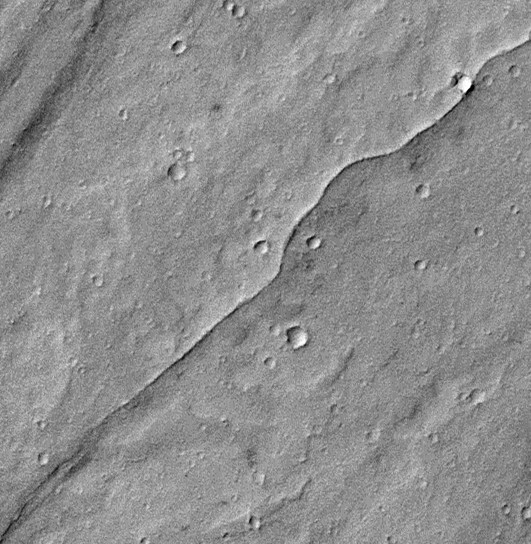
The lava channel on the northeast slopes of Arsia Mons which guided them up the mountain. Image: Mars Reconnaisance Orbiter
While Adewele was driving, the second engineer, Yaema Bah Amadu was plotting the course. This would have been easy with a working compass or GPS, but Mars as yet provided neither. The GPS satellites were planned but not yet active, and Mars had lost almost all of its magnetic field in its youth. There were still patches of an ancient magnetic field around in some places, in fact there was a usable magnetic field in a patch just southwest of Arsia Mons. But there was none here: the entire Tharsis bulge had become demagnetized when the hot magma intruded, and when it cooled there had no longer been a global magnetic field to re-assert itself. Finding their way up the mountain had been doable: it had been a matter of steering by the sun, following the ridge above the lava channel, and aiming up. But here, within the caldera, there were no features to help Yaema. They were setting down seismographs along their track, and the radio transmitters on these helped to maintain direction. About once a day, a satellite would come over and provide a connection with Olympia. But it was challenging to drive without any visual guidance from the non-existing scenery. An occasional impact crater provided some variety, but these were small and infrequent, and only visible once you were just about to drive into them. Yaema finally had enough, exclaiming ‘There is nothing here to see! We don’t need a route! Who cares where we are going?’
In contrast, Gerry Stevens felt elated. On this trip he had already had fulfilled his ideal to stand on top of one of Mars’ supervolcanoes, even if reaching the summit of Olympus Mons had not been possible. Strictly speaking Arsia Mons was ‘only’ 9 kilometer tall, but it stood on top of the immense Tharsis bulge which made it almost 18 kilometer in total, not that much below Olympus Mons. ‘I am happy to be here! We are the first people inside the largest caldera on Mars! This is history.’ It didn’t quite convince his small audience. ‘Yes, but why are we here? It is not for the view!’ Indeed, the flat, empty surface outside belied Gerry’s excitement for the location.
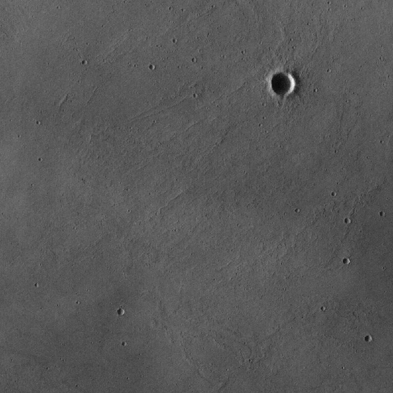
Detail of a near-featureless part of Arsia Mons caldera, HSRC/NASA. Click on image for full resolution
‘We could have gone to Pavonis Mons’ said Gerry. ‘It is closer to Olympia, and is a lower volcano, but the caldera is 4 kilometer deep: the view would have been great, but it would have been a hairy drive down into its caldera. Here we could almost just drive straight into the caldera, just a shallow slope down from the rim. The bottom of Pavonis’ caldera is just as flat as this one. And it is older.’
Elena Trofimova entered the dispute. As the expedition geologist, she had decided on the route. ‘This is the youngest surface on Mars!’ she answered! ‘Why do you think there are no craters here? They haven’t had time to form. If Mars will have another eruption, it will probably be here, in this caldera. Now let’s get those samples.’ This was a reminder to Yaema that he needed to collect rock samples from below the surface every few kilometres. Yaema didn’t like the job much. It meant digging through the Martian dust that covered everything here, set up a drill and collect a sample from several meters below the rock surface. They had brought equipment to drill 100 meters down, but this would be done only if needed, or if the seismic reflection data would show a layer of interest.
‘What do we need the samples for?” asked Yaeme. After all, it would be nice to know why this difficult task was needed! Gerry explained it – again. ‘We need more periodic table! On Earth, people have access to any element they need. It doesn’t matter what you need – there is always some place where it has been brought to the surface, or at least close to it. Mars is different. There is no plate tectonics, no subduction volcanism, and little erosion. Any deposit 20 kilometers below the surface would still be that far down! On Earth, you just had to wait and erosion would eventually bring the deposit to the surface. On Mars, that didn’t happen. And there is no water here, and some of Earth’s best minerals come from lake sediments. But Mars has this bunch of hot spot volcanoes, and these are our best chance of having formed mineable deposits closer to the surface. We didn’t find enough in Olympus Mons. Arsia Mons gives us a better chance.’
Yaeme went out and after some struggles requiring the help of Adewele, she managed to get the requested samples. With everyone back inside, plus the precious rocks, the driving continued. Even in these good conditions, it was slow going. They could only drive in bright daylight. Driving at noon was also best avoided, as the Sun was directly overhead here on the equator, and without shadows, rocks and pits could become invisible. Sometimes they would set up camp and stay for a day or two. On those days, Adewele got to operate the remote-controlled mini-rovers which were used for exploration. This was a task he enjoyed. It had to be be done carefully – everyone remembered the poor mini-rover which had triggered a landslide on Olympus Mons and was now deeply buried and lost forever with its cargo of rock samples!
In the evenings they continued the discussions about why they were here. Gerry seemed reluctant to say too much, but slowly they got the full story out of him. Elena of course knew already, but the others didn’t. Most people in the colony had little idea how precarious their existence had become. They were still receiving resources from Earth but transport was very expensive and infrequent, and the promised asteroid mines had never proven feasible. One failed transport could cause critical shortages. Now Gerry revealed the main hope for this journey. ‘We need lithium! We never found much on Mars. On Earth, it is mined mainly in lake sediments. Lithium in the mantle occurs at only 2 ppm. In basaltic rocks it reaches ten times that, but that is still far too low for mining. And it is too volatile: if a volcano would bring it to the surface, it would be expelled with the gases. The best chance to find it is where circulating water has brought up concentrated lithium from an almost solidified underground magma reservoir.’
‘There may have been a lake here’, he continued. ‘During the Martian ice ages, all these super volcanoes had glaciers on their northwest slopes. Ice could well have build up inside the shielded caldera as well. Any heat flow could have melted the ice underneath. This could have formed a lake of liquid water in the caldera, covered by the thick glacier ice. In that case, the surface here may have collected lithium – just like on Earth.’
Adewele and Yaeme looked puzzled, and Gerry realized the problem. Quite apart from them never having seen a lake, the top of a huge mountain on Mars was not the obvious place to imagine one. ‘Lakes can’t exist on Mars. The air pressure is far too low for liquid water to exist. But that isn’t a problem underneath a glacier. Images have shown that some of the lava forms on Arsia Mons look like pillow lavas, and these can only form in water. So it is possible that at one time there was a lake here. But even if not, hot water circulating underground could have brought material close to the surface. All you need is heat.’
The musical reference was lost on the others, and in any case, they didn’t seem convinced. Adewele wondered whether they shouldn’t be looking in Gale crater. After all, hadn’t that at one time contained a briny lake, of the kind where lithium was found on Earth? Perhaps, but those craters came from impacts, not volcanoes, so no one knew what to expect. And in any case, there were no deep, large craters near the colony.
The work continued as they slowly progressed across the caldera. The drilling revealed that the rocks below the surface were different from place to place, but they hadn’t yet been able to analyze them. A few times the drill broke through a hole underground. Gerry suggested these might be lava tubes: clearly, driving here was not quite as safe as they had thought. One drill bit broke underground, and it wasn’t clear why. Adewele thought they might have hit an iron meteorite. The route seemed to take forever and they began to realize the sheer size of the place – and this was only the central caldera! Adewele, always keen to explore maps, found an image of a lava flow which had emanated from Arsia Mons and half-covered a distant impact crater. ‘This is 800 km away!’ he exclaimed. Elena had a look and decided that that lava flow had been akin to a flood basalt on Earth. ‘It is what you get when a hot spot melts oceanic crust. On Earth, it will often melt continental crust which gives very different lava. Mars only has basaltic crust, similar to Earth’s oceans. This is what Hawai’i would have looked like without the Pacific Ocean.’ But no explanation could hide the enormity of the volcano they were exploring.

Mistretta Crater, 800 km south of Arsia Mont. To the left is the flood basalt that covered half the crater. Image from Mars Express. Source: https://www.geo.fu-berlin.de/geol/fachrichtungen/planet/press/archiv2014/mistretta1/index.html
After a particular hard drilling location, Yaeme came back carrying the prized sample. Holding the container in front of Gerry, she said ‘Look, it is just like any other rock on Mars! Where is this lithium?’ But Gerry calmly explained that they were still looking for the best place. The lithium was a by-product of a cooling magma chamber. As it cooled, one mineral after another would crystalize and drop to the bottom, thus forming layers of ore. ‘But some elements are incompatible and will not easily form such minerals. The last bit of liquid magma remaining will have these elements in it. The magma is no longer eruptible, and the liquid is stuck in place. But circulating water can bring it near the surface. We are looking for the last places where the magma was present below the surface of the caldera’. ‘Ah – I see we are getting to our goal’, he continued. ‘The scenery is changing.’
THEMIS image, NASA
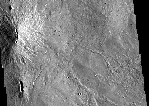
Indeed, a low rise had appeared on the horizon. ‘This will be one of the shield volcanoes here.’ ‘I thought we were already on a shield volcano’ interrupted Adewele. Elena answered: ‘The caldera of Arsis Mons has several small shield volcanoes inside it. There have been eruptions inside the caldera. The lava flows from the shields have covered quite a lot of the surface. Hold it! Careful!’ The last statement was aimed at Adewele. A deep, elongated hole had suddenly appeared in front of the rover. ‘That looks like a collapsed lava tube from one of those volcanoes.’ Adewele steered carefully around it, staying well away from the edges, and afterwards he drove notably slower. It had been a deep hole and they were far from any help. It made all of them realize that there was danger in this adventure. Elena did not help by telling them about the fault line that ran across the crater and which they had been following: the absent crater wall had been because they had entered through the area of this fault. ‘This crack is where the last liquid may have reached the surface. We have to follow it. The shield volcanoes are along this fault.’ Driving along a fault on top of a volcano alongside (or on top of?) lava tubes amidst small (although they did not look small) shield volcanoes didn’t seem to be quite the job they had signed up for. The surface had become more textured with obvious lava flows. Some of the edges of the flows were difficult to cross for the rover. A dust devil came close to the rover and had to be avoided. They had not really expected them at this altitude.
In the evening, camped next to the shield volcano, they continued the discussions. Yaeme wanted to know more about those mythical magma chambers. ‘What if it solidified completely underground?’ she asked. ‘Am I doing this work for nothing?’ Apparently not. ‘In that case’ answered Gerry, ‘you can get pegmatite, a kind of granite. On Earth, pegmatites sometimes can be mined for lithium, and they contain rare earth elements as well. It would be nice to find them on Mars, but they form too deep. On Earth, you find them in old crust which has been deeply eroded. There isn’t so much erosion on Mars! But a magma chamber the size of Arsia Mons would be perfect, and pegmatites might be close to the surface here. Look!’ Everyone looked, but no one saw anything – the immense dusty plain stretching beyond the horizon was hidden in darkness. ‘This is the largest caldera in Mars. It is more than 100 km across. Imagine the size of the magma chamber that formed this! On Earth, you would have called this area a LIP!’ Again he received looks of confusion, until Elena clarified. ‘A large igneous province. They are the largest eruptions on Earth. The Tharsis Bulge is bigger though than those. And this volcano formed on top of this bulge.’

Lepiodite, a lithium-containing pegmatite
The next day, as the rover drove on, the discussion turned to the age of the caldera. Adewele wanted to know how they knew it was so young? Elena did the explaining. It was a matter of the number of impact craters within the caldera. There were almost no craters larger than 1 kilometer, although these were numerous elsewhere on Mars. Research done back on Earth had found 29 volcanic vents and associated lava flows within the caldera, which overlapped each other. By counting the number of craters in each flow field, they found that the average age was about 150 million years but some seemed rather younger, perhaps as young as 100 million years. Not everyone had been convinced: the fields were perhaps a bit small for crater counting, and smaller craters might been lost due to the dust cover. The team did notice that the ever-present dust layer seemed considerably deeper than they had expected at this height. Gerry dug out an old document on his laptop saying that at times dust in the thin atmosphere was raised to above Arsia Mons by seasonal winds (something that did not seem to happen at the other Tharsis volcanoes), but that the winds here were rarely strong enough to remove the dust again. So the dust layer was very slowly increasing with time. Craters smaller than 10-20 meters might have been completely buried in dust – one reason to drive with care!
They now regularly saw collapsed lava tubes. Adewele began to use the remote-controlled mini rovers to explore the way ahead. Gerry noted how the collapse features all seemed to be pointing roughly in the NS to NW-SE direction, which was funny because the lava flows themselves had been going in all directions. In fact the direction of the lava tubes pointed approximately at the other two Tharsis volcanoes, Pavonis Mons and Ascraeus Mons, 400 and 800 kilometers away. This direction seemed present everywhere they looked. It was the same direction as the fault which had nearly breached at the NNW side. The lava flows inside the caldera all seemed to come from the line connecting these features. Elena had seen enough. ‘This whole volcano has behaved like a rift zone’, she exclaimed. ‘It looks like Iceland!’. None of them had ever seen Iceland, so this fell on deaf ears. ‘The volcanoes on Iceland have linear rift zones’, she explained. ‘The lava tends to flow underground along these zones, until it finds somewhere where it can erupt. Because it is a spreading centre, with the sides being pulled apart, there is little stress in this direction – and lava will always go in the direction of least resistance.’

Source: wikipedia
This led to an animated discussion how Mars could have a spreading centre without plate tectonics. There was nothing that could be pulling the sides apart. ‘Yes there is’ argued Elena. ‘Gravity!’ The Tharsis bulge is enormous. It is large enough that it cracked the crust, and gravity is pulling the sides down. All three volcanoes are build on the crack in the crust.’ Gerry argued that they should not discount the possibility of a hotspot trail, similar to Hawaii, but Elena was having none of it. ‘Hot spot volcanoes don’t have linear rift zones, and they have an age sequence. The three Tharsis volcanoes all have similar ages.’ The discussion was interrupted by a shout from Adewele, followed by a tilt of the rover which threw the three passengers forward. He had driven into a dust-covered crater – whether accidentally or deliberately to stop the heated arguments became itself an argument. It took Yaeme some time to dig out the rover from its predicament.
After this, the team decided to make more use of their drones. They were nothing like drones on Earth: propellers were not much use in the almost absent air, and the drones were little more than tethered airbags. The images that came back showed the team they had been lucky. ‘Look at that!’ Yaeme said. ‘There are craters everywhere.’ Indeed, the view was littered with small craters, buried in dust but just visible in the light. They would have to be very cautious.
Gerry was wondering what the caldera would have looked like when it formed. In spite of its huge size, there only seemed to be a single caldera. The other volcanoes had overlapping calderas, but Arsia Mons did not. Had it formed in one final, huge event? The volume of the caldera was 4000 km3. Where had all that magma gone? And why was the caldera so flat and shallow? That seemed easier to explain: it looked as if the entire 120-kilometer wide caldera had been filled with a lava lake that had solidified in place. The lava flows from the shields on top, although they seemed to cover the entire caldera, were thin and only amounted to 100 km3 or so. Adewele, though, was more interested in the possibility of explosive eruptions, perhaps because he was wondering about their safety if a sudden explosion were to happen underneath his rover! Elena looked thoughtful at that remark, but then shook her head. ‘No, the explosions happened a long time ago. There is a large area west of here which seems to be covered in pyroclastic deposits. It is called the Medusae Fossae Formation, and stretches long the equator for over 6000 km. The layer seems to be 10 meters thick at the east but 3 kilometers thick close to Tharsis. There must have been huge explosions with more than 1 million cubic kilometers in pyroclastics, but we don’t know from where. It may have been further to the west, hidden underneath the layer, or from Tharsis but before the big volcanoes grew. Either way, the time of explosions on Mars has passed.’ Gerry added that in spring, a huge orographic cloud often formed on one side of Arsia Mons, caused by the heating of the surface and the strong winds. People back on Earth had at one time even mistaken this cloud for an actual eruption.

Orographic cloud from Arsia Mons. Source: Mars Express/ESA
But here Yaeme found a surprise for them. Drilling a few meters down had turned up the lava flows on top, and on Gerry’s request he had been drilling deeper. And below the lava she now found a fifty meter thick layer which looked like low density rubble. Elena immediately identified it. ‘Tuff!’ she pronounced. Everyone agreed with that. ‘No’, she said, ‘Tuff! Not tough. These are deposits of ash and tephra from volcanic explosions!’ A brief discussion made Gerry remember that an old radar measurement had indeed revealed such a low density layer below the surface, and suggested it might have been explosive ejecta. Elena wondered whether the shield volcanoes inside the caldera had all started out as rift fires, such as she had told about happened in Iceland, before changing to a shield-building phase. But for Yaeme it was bad news as she now had to drill more than 50 meters deep which was time consuming. She also lost a second drill bit in that process.
At the end of their two-week exploration the team drove back to the Graf, tired but excited by the work. The journey had been eventful. The airbag drones had been hit by a surprise dust devil. The tethers had survived but some drones had not. The rover had twice driven into hidden dust traps, and there were so many underground lava channels, sometimes with very thin roofs, that they had resorted to use sonar to find safe passage ways. Most of the driving around the shield volcanoes had to be done in the early mornings and late evenings, when the long shadows revealed the tell-tale indentations of the landscape. The drills and the seismic reflection profiles had shown that there had been many more than the 29 known lava flows in the caldera, some completely covered by later flows; the layer of tuff seemed to be present mainly near the line of shield volcanoes. Whether the overlaying flows had come from the same eruption, or aeons later, they could not tell: they hoped this could be discovered by analysing the drill cores for thermal alteration of the rocks. Getting close to the caldera rim had been exciting, and perhaps unwise: the steep walls, hundreds of meters high, with deep dust piled up underneath created a sense of danger. Deep faults had made driving here hazardous and they had quickly turned around. The seismographs that they had set down across the caldera had so far not registered any natural shaking, apart from wind. But they remained active and if there was still life in Arsia Mons, they would eventually detect it. Although perhaps it was more likely that they would detect a collapse of the crater wall. In places the caldera rim had seemed very unstable, with fractures which looked like they could give way at any moment. It seemed likely that any meteor impact near the rim would have caused a collapse and would have buried anything too close to the edge.
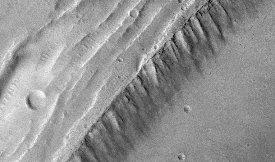
Detail of the rim, showing the layered structure. The ripples are sand dunes. Mars Reconnaisance orbiter

An impact crater at the southern edge which caused a collapse along the rim. Material from inside the caldera flowed into the crater, and was later mostly buried by a collapse of the eastern crater rim. There is a lack of visible craters close to the impact crater on the floor of the caldera, showing that some have been buried. Notice the vaguely visible craters on the floor of the depression. Some further craters have formed after the collapse. The crater has a diameter of almost 10 kilometer and the entrance to the crater is about 1.4 kilometer across.
The lack of scenery had turned out to be only skin-deep: underneath the monotonous surface was evidence for a rich volcanic history. The small shield volcanoes were found to have formed above long lava tubes. Where the lava had come from was still unclear, but it had been flowing only just below the surface, in structures intermediate between lava tubes and magma dykes on Earth. Adewele had found some beautiful circular structures, kilometers across and completely buried apart from a vaguely visible rim. To the team, these invisible craters showed that the caldera itself was older than they had expected. ‘If I would make a guess, it could be anywhere between 3 billion years and 300 million years old’ thought Elena. The tephra and lava layers which had buried the older surface were younger, but again it was hard to say by how much. It could be as young as 100-200 million years.

A buried crater is vaguely visible as a round rim, mainly to the north and east. The diameter is about 1.7 kilometer. It is located about 35 kilometer south of the centre of the caldera, and about 12 kilometer east.
They had taken heat measurements wherever they found cracks in the surface, but there was no evidence of heat still coming out. It was possible that the dust which covered so much was insulating the heat, but it didn’t seem that there was much life left in the mountain. So why had the mountain come back to life, a few hundred million years ago? They couldn’t tell.
They left the caldera the way they had come, and slowly drove down the 5 degree incline. They had left the Graf at the top of the ‘apron’, a huge deposit on the northwest side of Arsia Mons. Here they did their last investigations. The two aprons on either side followed roughly the same fault line as all other features had. Underneath the dust, they found that the aprons were huge lava flows. They even found the openings through which they had erupted, just above the level of the apron, looking like immense lava tubes. Adewele wasn’t too happy with Gerry’s suggestion that they should drive into one of these! Elena thought that these tubes explained the caldera. ‘Look! This is where the magma chamber emptied! It followed the fault – it must really have been behaving like a rift. Dykes and tubes followed the rift, and emptied the chamber on both sides. This is what collapsed the caldera’. Everyone was too tired to argue. Only later would it occur to them that this meant that the three supervolcanoes had sprung up from a non-spreading spreading rift on top of the Tharsis bulge, which then had dissected Arsia Mons and caused further, smaller volcanoes to grow up on top of it. This multi-layered structure of volcano upon volcano was an extraordinary image, much like the old Sinphonaptera: Big fleas have little fleas upon their backs to bite ’em,// And little fleas have lesser fleas, and so, ad infinitum. Here the fleas were the size of volcanoes, and the biggest flea of all was the Tharsis Bulge itself, covering 20% of the entire planet. Perhaps the newly arrived humans were to be the smallest fleas!
But that came later. Gerry took one last look at the volcano he had wanted to climb so badly, while the others finished loading the Graf transporter. But the rim of the caldera was over the horizon; from here, halfway up the slope, the mountain itself was invisible. It was time to go home. Perhaps the rocks they now carried on the transporter would contain what the colony hoped for. But if not, they would look elsewhere. As the landscape darkened with the setting sun, he knew they were on Mars to stay. This world was their home.
Based on ideas provided by Henrik

This artist’s concept depicts astronauts and human habitats on Mars. Source: NASA


Mars Meteorites that was ejected from lava flows during impact events been dated chemicaly and physicaly when they crystalinze
The most recent magmas on Mars cooled 140 million years ago.
(full resolution at photojournal.jpl.nasa.gov/figures/PIA22432_fig1.jpg)
Here is an extremely Young Mars lava flow
No dust on it, No impact craters on it.
Looks brand new possibely pliocene age?
Mars is smaller than Earth,
But much larger than our Moon.
It cooled faster than Earth,
But much slower than earths moon.
It coud still be active every few 10 s of millions of years.
Mars is in its last gasps of volcanic activity
Comment edited to replace full image with the thumbnail
https://www.jpl.nasa.gov/spaceimages/details.php?id=PIA22432
That is the region where InSight landed. There are some young=looking areas there.
Look at the photo here
It looks brand new!
Looks like it coud be just a few 100 s of thousands of years old.
Mars thermal evolution should be between Earth and the Moon sizewise
Not that young. Imagine a lava flow on Earth. You wouldn’t say it is pliocene because it has no impact craters on it. Even on Mars, craters don’t form that quickly. But could be less than 100 million years, that is possible.
This lava flow is an inflated pahoehoe flow based on textures and flow edges.
Most Tharsis flows are channelized lobate Aa flows
Quite a thin flow: you can see the older surface features through it. Low viscosity.
What do you think this is?
That coud be a very very recent impact crater ( year old )
Here is a slightly larger view
Note the light discolouration in two bands extending from the blackness. Also note that the roundish back hole has no light rim and that just to the northeast is blotchy. The first suggest a vertical pit (collapse?), and the second that you see black material on the surface either on top of the light coloured material or from removal of this light layer. Note the southeast-northwest stripes in the images, which looks like wind-blown stuff (dust devil trails?). The stripes are darker, suggesting the material just below the surface is darker. I.e., everything you see in the entire image is dust covered.
Here is another detail from your image
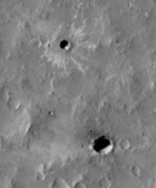
Note the structure around the top crater. It looks like what you get from an impact in mud. You could get this from an impact on ice.
It was indeed an impact crater
And Elon Musks Mars Plans seems very rushed
But StarShip is indeed under construction now.
Do you think Musk will supprise the world when he gets to the moon rather early soon ?
Or will SpaceX s starship be a total failure?
I think it is high risk. It is easier now to develop rockets but manned travel requires very high reliability. It would be game-changing if he succeeds and we need something like that. People who dream the impossible can change the world. If other people do the hard work.
Albert hahaha
Sometimes I imagine Elon Musk s SpaceX to be the start of something like the Weyland-Yutani Corporation ;).
But thats very unlikley with todays technology
Talking of InSight – the mole is moving again! – slowly…
https://mars.nasa.gov/news/8529/mars-insights-mole-is-moving-again/
That’s about 10years ago that I noticed my browser was loading this photo from line to line. How heavy is this?
Yes, Jesper linked to a huge image located on a slowish server. The image has now been replaced with its thumbnail.
That was brilliant, really well written.
Thank you for taking me along on a journey into a Martian volcano.
Now this long-time lurker is off to learn more about Mars!
Also thanks to Jesper for the link and the amazing images found there.
At least with Mars, if a TBM ever gets built there, the likelihood of getting it stuck on an old burried locomotive or pipe should be low.
How You doing with the weather, Lurk?
Bit of rain, enough to make me sleep quite well. Pretty much no wind that I noticed.
The Pekinese who is deathly afraid of everything (even light showers) snored all the way through it, nary a wimper.
Smart! Look around the problem if you can’t see directly into it.
https://www.forbes.com/sites/briankoberlein/2019/10/19/to-study-alien-worlds-astronomers-look-to-white-dwarfs/#2250a365c985
well i liked it……. Thanks, Albert! a bit of fact based whimsy. The beginning of a best selling novel? Best!motsfo
I wants a probe landed on Olympus Mons caldera
The problem with that is that the air density pressure is extremely low!
The typical atmospheric pressure at the top of Olympus Mons is 72 pascals,
About 12% of the average Martian surface pressure of 600 pascals
Everest Summit is 32 000 pascals pressure!
A paracute may open on the supersonic way down to the caldera: but it will hardly work at all to slow the probe. So brake rockets must be fitted to the probe.
Also its probaly too dusty there for a Olympus Mons Curiosity Rover and there is nothing intresting at all to see more than volcanic features.
Olympus Mons have no preserved fossilized microbes
You don’t know that. It could be home to the bandersnatch.
Couple of stars in Iceland
Sunday
20.10.2019 12:06:59 66.371 -17.057 1.5 km 3.1 90.04 28.1 km WNW of Kópasker
Sunday
20.10.2019 11:03:36 66.369 -17.064 7.0 km 3.2 99.0 28.3 km WNW of Kópasker
Earthquake count:
Magnitude less than 1 in all: 57
Magnitude 1 to 2 in all: 203
Magnitude 2 to 3 in all: 33
Magnitude more than 3 in all: 2
Total: 295
Time and magnitude of earthquake
– Source: Icelandic Meteorological Office.
One star now as the second has now been downgraded to 2.9 – unless it changes again
Sunday
20.10.2019 12:06:59 66.373 -17.055 7.8 km 2.9 99.0 28.1 km WNW of Kópaske
Latest activity
Sunday
20.10.2019 12:47:12 66.371 -17.019 5.0 km 1.7 90.01 26.4 km WNW of Kópasker
Sunday
20.10.2019 12:46:37 66.343 -17.013 1.1 km 1.7 90.01 25.5 km W of Kópasker
Sunday
20.10.2019 12:46:12 66.347 -17.044 0.7 km 1.3 90.01 26.9 km W of Kópasker
Sunday
20.10.2019 12:44:32 66.383 -17.013 17.2 km 1.6 90.01 26.6 km WNW of Kópasker
Mánáreyjar Volcano
As some have noticed there is an ongoing swarm at Mánáreyjar Volcano.
This happens on a yearly basis, and often involves earthquakes above M3+. The maximum possible tectonic release in the area is M7.
The swarms are normally Volcano-Tectonic and is a part of the spreading of Iceland as magma rushes in through dykes and sills to fill up the voids that are created.
This is a volcano that would be highly noise during a runup, and would have an extended period of earthquake swarms prior to erupting. If this continues for a week and with powerful M3+ earthquakes, with several M4s, then it is time to hope for an eruption. But, nothing seems to be on that scale from this moderate intrusion.
If there is an eruption then that would mean that there would be no winners for the poll.
ROFLOL
I think we would be all winning a new island if it happens 🙂
Still highly possible. Iceland has been rapidly growing in size.
It grew during the eruptions of Laki and Elgja and these increased the coastline of Iceland, by creating lava fields towards the sea.
The 1918 Katla eruption also extended the southern coastline by 5km!
Then the eruptions in the Westman Islands created new land.
In 1996 the glacial flood from Grimsvotn also extended the southeast coastline by depositing many sediments there.
Iceland has been growing quickly. So a new island is totally possible and even expectable within a short geological time.
It will definitely happen sooner or later. Mánáreyjar are the remnants of previous islands that have ben washed away, so it is the proto-stage of a permanent island formation.
Technically we could get an island near Reykjanes Peninsula, but it would probably not be stable, or we could get one more, or larger ones at the Vestmannaeyjar.
Question is just where we will get an island, Iceland tends to pop one or two every century.
You did though forget the 2.5cm spread causing a heck of a lot of country every year 🙂
It spreads by this rate. But it also goes down as it moves out.. and the island doesn’t grow from the spreading. The only winner is the Atlantic Ocean.
If the eastern rift zone extends further south, Iceland will look quite different in the future. Of course this might mean a slow demise of the Reykjanes peninsula
I would love to brag about seeing an island’s birth to my kids (:
Actually the end GPS-stations are showing clear growth, the going down happens further out in the ocean.
Obviously there is a limit to how large the Island can grow, but that is about 50km west and 150km east.
Not even the oceans are grinding fast enough to stop the growth.
The height of Iceland is set by the density and thickness of the crust. The thickness away from the spreading centre is set by the spreading rate, and goes down as the crust speeds up away from the centre. (The spreading rate lower in the crust is very small near the spreading centre, and speeds up further away). The density of the crust increases when it cools, and it will cool as it moves away from the hot spot. That is why Iceland is highest near the hot spot. So as the crust moves away, it sinks down. Eventually it sinks below sea level and that is the edge of Iceland. So the crust keeps spreading, but Iceland isn’t growing – at least not from that. It can increase if the hot spot heats up, of course.
Did you miss the two islands that popped up a few years ago in the Red Sea?
The most exciting will be when Reykjanes Penninsula does another fire
Imagine Aa and Pahoehoe eating up Grindavik and blue lagoon buried. Smoke and fumes everywhere and turists mass fly to Iceland to drive from Reykjavik and see the active flows enter the ocean.
There is a limit how large a volcanic Island can grow??
Hawaii is huge
Iceland is huge
They are both purely volcanic
And both will grow quite a bit larger before their glory days are over Carl…
Iceland is becomming a small flood basalt plateau its growing into a LIP
A large Igenous province Iceland will become: if its already not that?
Iceland is a LIP right?
Yep I missed those island’s growth,i was to busy looking at something pervy
“looking at something pervy”..?
There is a story here 🙂
I should withhold that information for the sake of keeping this site PG.
This site has not been PG since 3 elderly very English ladies had to explain the concept of Dogging to me.
I had used the word in an article, without having a clue about the second meaning of the word.
Hilarity ensued as they tried in a very circumspect way to clue me in, not understanding that I was highly clueless…
Edit: The sentence I had written was: “To doggedly dog where no dog has doggedly dogged before”. It did not even contain the word dogging, and all of a sudden I was deemed to be a naughty boy. All of the English persuasion was on one side, and everyone else was incredulous as we learned about this particularly English pastime.
Well then, I’ll just say that I love athletic Asian women almost as like volcanoes and weather.
That being said what would you make of the deeper seismic activity and the fact that all of that swarms came really quick. peaked and seems to be falling just as fast?
Stamina problems in combination with magmatic dysfunction.
Well it would seem that things are moving at a snail’s pace with volcanoes and other stuff in my life. Maybe i should look at some more athletic asian women
Closer look via “IMO – Tjörnes fracture zone (small)”
If I’d have waited a few minutes I’d have got another green star.
Sunday
20.10.2019 19:19:38 66.366 -17.052 16.7 km 3.1 99.0 27.7 km WNW of Kópaske
And upgraded to 3.2
Sunday
20.10.2019 19:19:38 66.365 -17.054 9.0 km 3.2 99.0 27.8 km WNW of Kópasker
Tremor under Katla. Or is it only echo from the Tjörnes activity?
http://hraun.vedur.is/ja/Katla/
Upgraded again to 3.5
Sunday
20.10.2019 19:19:38 66.366 -17.046 16.4 km 3.5 99.0 27.5 km WNW of Kópasker
Total of 3 stars now but rates have slowed for now.
Might be geothermal activity.
Activity seemed confined to Katla.
Anyways it is past and such activity is rather common.
Sometimes it is also just stormy weather.
Some earthquakes seem volcanic, as they are 20+ km deep. That’s more magmatic than tectonic.
The line between both is often blurred in Iceland.
Don’t know how to post images, but will give it a try anyways:
Awesome visualisation courtesy of https://baering.github.io/earthquakes/visualization.html
This article assumes that human beings have already fully adapted to the Mars Planet. but today there are serious unknowns about the Martian colonies …. Elon Musk already implied: “Volunteers to go to Mars for life”.
After a few years, adults lose the ability to return to Earth, their skeletons and muscles adjust to the gravity of Mars and no longer go back … And the children of women who conceive on Mars, develop a Martian body , of optimal conditions for the Planet, but are unable to travel to Earth, here they would be permanently disabled. The colonies need to develop a total independence from the Earth, otherwise they cannot be transferred to the Earth in case of serious clinical operations … “Anyway, if you travel to Mars it is forever” …
Thats true
And even worse for those who are born on a Lunar Colony!
When they get back to earth, they are crushed by gravity
You have to distinguish between physiological and genetic adaptation. The first goes quickly and alse reverse quickly. Genetic adaptation (Darwinian evolution) takes at least tens or hundreds of generations if the selection pressure is very strong. We alre speaking millenias or many millenias… 😊
Hi Albert: I have a question
Whats the air pressure in Arsia Mons caldera?
How high is the same air pressure on Earth?
I knows that Mars surface pressure is equal to 34 km up above Earths surface
Try this:
https://www.mide.com/pages/interplanetary-air-pressure-at-altitude-calculator
Do note the warning: ‘Extraterrestrial use may void the warranties on your measuring instruments’
Wow looks like its only almost 1/1000 th of earths surface pressure! ( little higher ) but many 100 s of times lower than Earth surface pressure!
Will the sky be dark at Arsia Mons summit?
Is it enough above the dust storms?
No, Arsia Mons does get affected by dust storms and clouds can form above the level of the mountain
Thanks for another great article, Albert.
Here’s a pic today of my favorite volcano, Klyochevschoy (or however you spell it):
And Jesper.. how well do you think a quadracopter would do on Mars? I think quite well.
And some of us picked the volcano off Grimsey, Nafir-skjalsomething in the contest. Looking good!
Probaly not: at least not the ones on the market.
Mars atmosphere is extremely thin
To work on Mars
Rotorblades haves to be very long and broad
And they must spinn extremely extremely fast.
To generate any lift in Mars very thin air pressure.
But the lower gravity aids too
That is why we proposed an airship for transport on Mars. They will work even at that pressure, can be propelled by jets (carefully) and can be covered in solar panels. They need to be huge, obviously.
Is it true that Arsia Mons is acually larger than Olympus Mons?
It seems to be broader and its lava flows extends much farther too.
When you haves a very thick in – mobile litopshere huge volcanoes and mountains becomes a possibility.
How thick is Mars avarge litopshere depth?
Earth is around 100 km thick on avarge.
Mars is smaller and cooled much more
I says Mars litopshere is many many 100 s of kilometer thick?
Olympus Mons is very tall but other volcanoes of Tharsis are much more extensive and maybe more voluminous (but I ignore any numbers), particularly Alba Mons, Arsia Mons and the Syria Planum volcano.
This version of Mars global elevation model is shaded in a way that gives a different perspetive of the surface and shows what I mean:
https://www.flickr.com/photos/kevinmgill/6905982671/in/photostream/
Thank you and holy crap how cratered Mars is in that map.
Its a smaller and less active planet than Earth
But never knew there impact craters where this many!
Especially the southern hemisphere is very old, so it is pockmarked with craters, many very old. Earth has lost them due to erosion and plate tectonics. The northern hemisphere is a younger surface, although still older even than Australia. It has a layer of sediment, and in places you can see (vaguely) the outlines of buried craters.
Google Mars is a good place to start exploring.
How thick is Mars litosphere Albert?
Earths avarge is 100 km
Mars is 300 km thick avarge litosphere depthness?
the 2020 mission to Mars includes a helicopter drone:
Imagine how fast these blades must spinn to generate lift in Mars thin atmosphere?
Very very fast indeed.
Im excited when they will fly it on Mars
About ten times faster than our helicopters, and they are very light weight. They can carry camera but not much else. However, that is fine because Mars missions have to carry as little weight as possible anyway.
https://youtu.be/oOMQOqKRWjU
Albert woud that helicopter work on Arsia Mons summit?
It will not right?
Too thin pressure up there?
It is difficult to see how it could work there. Note that pressure varies a lot between summer and winter because so much of the atmosphere freezes out in the southern polar region. So the ‘copters may need the right season.
Dont take off your spacesuit on Mars
It will be disasterous!
All body fluids starts boiling
Instantly all air in loungs are sucked out and one dropes dead in less than a minute.
And after a few weeks you become a freeze dried mummy for many billions of years
Volcano burps big bubbles
https://phys.org/news/2019-10-infrasound-underwater-volcano-erupting-formation.html
Just imaging if as ship or a boat fall into one of those bubbles 400m across!! 😬
New post is up! You can’t typecast eruptions – or so we thought
https://www.volcanocafe.org/typing-eruptions/