
A fun question: which are the southernmost, most equatorial and northernmost volcanoes in the world? We need to add two provisos here, otherwise this question is impossible to answer: the volcano should be on land (sub-aerial, not sub-marine), and it should not be extinct but be known to have erupted.
I’ll give you a few minutes to think about. Two of them should present no problem. Volcanoes are thick like flies near the equator, but are very sparse close to the poles.

Ready? Number 1 is Erebus (77 degrees South) – no problem there. Number 2 is harder – your answer in the comments, please. And number 3 is that rare mountain: a volcano with a Dutch name and even taller than the (mythical) Zuidwal volcano. (We are happy to see that the VC review of this volcano is among the few sites that have survived google’s culling.) It is the infamous Beerenberg on Jan Mayen island (72 degrees North). The infamosity is because its eruptions are nearly impossible to observe. Most of the time the island is covered in the North Atlantic cloud and fog, and if an eruption were to happen during clear weather, very few people are anywhere near close enough to see it.
(One may wonder whether volcanoes try to avoid the polar regions. There are some 1350 active volcanoes on Earth, which is an average of 1 volcano per 350,000 square kilometer. About 10% of the Earth’s surface is closer than 15 degrees to the poles. So one might expect 10% of its volcanoes there – rather more than just 2! The reason for the lack of volcanoes is that the major active rifts and subduction zone currently avoid the polar regions, that the Arctic is mainly sea and submarine volcanoes tend not to be on the list of active volcanoes, and finally that the Antarctic ice sheet (and probably Greenland’s as well) hides and suppresses volcanic activity.)
Discovery
It is likely that Jan Mayen was the original Svalbard, as named by the Vikings on Iceland. But the island had little or no use to them, was never settled and became forgotten again. Nowadays, the name has been transfered to Spitzbergen, much further north but regrettably non-volcanic.
The island was (re-?)discovered in 1614 and 1615, by several ships. Of course, just finding the island was not enough. The discovery had to be reported to the ship’s owners, and then by the owners to the official channels. The first one to find it reported it the funders, but they kept its secret for commercial reasons. The second and third ship arrived (together) while the first ship was still there. All three ships were Dutch. A year later, an English ship followed. By now the island had been given four separate names, including the old Viking one. The French added a 5th one 20 years later. None of these names were to stick.
All of the ships made maps, of varying accuracy, and these indicated names for separate features. One of those features (a small promontory) had been named ‘May’ after the captain of one of the ships. A few years later, this map was redrawn to become part of the famous Bleau atlas (the most famous atlas you have never heard of). On this map, the name ‘Ioanne Mayen’ was now assigned to the entire island, overruling all other names. (the ‘en’ ending means the same as the ‘ ’s’ in English.) Hence the name ‘Jan Mayen island’, immortalizing Captain Jan Jacobszoon May van Schellinkhout of the ship ‘Golden Cat’. The island was used as a whaling base for the next 20 years, but the whales soon ran out (or swam off) and Jan Mayen Island became abandoned.

Since 1930 the island has been Norwegian, being donated to the country by the League of Nations. Norway has had to repel attempts of hostile take-overs by Germany in 1940 and by Iceland(!) in 1979. The latter dispute was initially about fishing rights. Owning an island gives a nation a 200-nautical-mile economic zone around it. This zone overlapped between Jan Mayen and Iceland. When this area became economically important (i.e. exploitable fish resources), this led to a territorial dispute. Initially Iceland denied that Jan Mayen was an island! It also claimed that Jan Mayen was part of the continental shelf of Iceland. Neither claim seems particularly strong, in hindsight. But the dispute led to a formal, internationally recognized (though not by all countries) definition of an island:
“An island is a naturally formed area of land, surrounded by water, which is above water at high tide. [..] The territorial sea, the contiguous zone , the exclusive economic zone and the continental shelf of an island are determined in accordance with the provisions applicable to other land territory. Rocks which cannot sustain human habitation or economic life of their own shall have no exclusive economic zone or continental shelf.”
Thus, Jan Mayen became an island! The dispute was resolved peacefully (Iceland got a little more out of it than Norway) and the exploitation of the disputed area was shared. The problem has now become relevant in other places of the world, especially the South China Sea where there seems to be less willingness to resolve the claims in the Scandinavian way.
And so Norway became in possession of some fish, a sliver of continental shelf originally from Greenland, possibly oil or gas resources on this shelf, and an active volcano.
The fish may have reason to be concerned. Norway may nowadays be known as a country sympathetic to ‘green’ issues, it has a distinctly ‘non-green’ history. Norwegian hunters arrived on Jan Mayen in 1906 and quickly left the island devoid of life. As elsewhere in the arctic, musk ox and polar foxes were present, but here they were hunted to extinction. There is also little flora (there is an endemic species of dandelion), and even the omni-present polar bears have largely disappeared, although in their case because of global warming which has raised average temperatures here to above freezing – even in winter drift ice now rarely reaches Jan Mayen. To see the arctic in all its life, go elsewhere: Greenland or even Spitsbergen have fared much better.
Jan Mayen Island was declared a nature reserve in 2010; severe restrictions on tourists have made visits nearly impossible. It is not clear what the reserve is intended to protect – the statement was made that it ‘is a poorly understood ecosystem that needs to be protected from risks unknown’. Perhaps ecosystem means the local military base! Sea birds still breed here in splendid isolation and protection, but other bird species are absent because of the lack of vegetation. There is no tundra here – just rock, in places covered by moss and lichen and the occasional lost plant.
There an interesting aside to the story how Jan Mayen became an island. The Kolbeinsey Ridge is named after a valley in Iceland, or rather, to a settler who lived there: Kolbeinn Sigmundarson. In an angry mood (a common problem among the Vikings of a millennium ago, apparently), he managed to crash his ship into a rock in the North Atlantic, and lost his ship, his crew and his life. After this the rock acquired his name: it is a small island north of Grimsey (and located on the Kolbeinsey ridge). In the middle ages, Kolbeinsey was a 700 meter island . Over time it eroded and after 2000 it remained as two rocklets, now only visible at low tide. Iceland used this island (at that time still above water) to extend its 200 nautical mile fishing zone and even built a helicopter landing base to strengthen the claim. (The helipad was lost to the sea 20 years ago.) The redefinition of ‘island’ meant that Kolbeinsey no longer qualified and Iceland had to give up some of its fishing claim. You win some, you lose some. But losing an island must hurt.
Jan Mayen island

Jan Mayen is 700,000 years old, is 54 km long and has an area of 380 square km. The climate is cold maritime, and the North Atlantic weather is fog, wind and drizzle. The island consists of three parts. The larger northern part is dominated by the volcano called Beerenberg, 25 km wide and over 2200 meters tall. Beerenberg may be the tallest mountain in the world with a Dutch name! Towards the southwest is a narrow peninsula, 6 km wide and 600 meter high, connected to the northern part by a 2km-wide low isthmus. The three parts are simply called Nord-Jan, Midt-Jan and Sor-Jan. Sor-Jan is in effect a volcanic ridge, up to 700 meter high. Midt-Jan is a lower, narrow ridge which lacks volcanics. It contains a large lagoon on the south side which dries up in summer. Nord-Jan is in effect a synonym for Beerenberg.
Beerenberg is that rare beast, a stratovolcano built from basaltic lavas. The mountain consists of a broad base, rising at an angle 30 degrees to 1500 meters altitude, with a much steeper cone (45 degree) on top forming the summit. The reported height of 2277m seems to come from quite an old measurement. There is no recent confirmation of this value and the only topographic summit map I have found doesn’t reach quite so high. There is a volcanic ridge extending to the northeast, terminating in cliffs with a low platform near sea level (Nordkapp) which is from more recent volcanics.
Jan Mayen Island can be seen as a 50-km long volcanic fissure (or two offset fissures, one for Sor-Jan and one for Nord-Jan), with a single volcano (Beerenberg) superposed. The inhabited (if not fully habitable) part of the island is the Sor-Jan peninsula. The main town is called, somewhat optimistically, Olonkin City. It has a year-round population of 15 men and 3 women (that was in 2019). People are allowed to live on the island for a maximum of one year.

© Rolf Stange – Jan Mayen. Reproduced from https://www.jan-mayen.com/jan-mayen-information.html by permission. Not for redistribution.
Black circles: 17th century whaling stations. White circles: 17th century whaling stations (assumed). Squares: Stations (1. Eldste Metten = weather station 1921-1940. 2. Jøssingdalen (weather station 1941-46 and garrison), 3. Atlantic City (US Coastguard station, 1943-46, weather station 1946-49) 4. Gamle Metten (weather station 1946-62), 5. Olonkinbyen (today’s Norwegian station, active since 1958), 6. Helenesanden (weather department of the station since 1962).
Breen = glacier, bukta = bay, Kapp = cape, Nylandet = New Land, sletta = plain, Vika = small bay.

Source Pall Imsland, 1978 Nordic Volcanological Institute 78, 13 https://nordvulk.hi.is/sites/nordvulk.hi.is/files/NVI_Reports_pdf/nvi_report_7813_low_text.pdf
The microcontinent
Jan Mayen is the tip of an iceberg. Look under water and a complex region surfaces. To the south, a thin ridge extends 300 km towards Iceland, eventually ending in the Jan Mayen trough. This sliver is called the Jan Mayen Ridge; it has a flat top of 10-30 km wide. On the north side runs a fault zone, the West Jan Mayen Fault Zone, which frequently has minor earthquakes, such as in the last few weeks, or even major ones such as the magnitude 6.4 in March this year. Towards the northeast runs one of the Atlantic mid-oceanic rifts, the Mohn’s Ridge. It terminates at the fault zone, jumps west and continues there as the Kolbeinsey Ridge which connects to the north coast of Iceland. Southwest of Jan Mayen runs another fault zone, called (you guessed it) the East Jan Mayen Fault Zone. Far east it connects to yet another Atlantic mid-oceanic rift (the Atlantic is full of them), named the Aegir Ridge. This one is inactive.

Clearly, interesting things have happened here.
Some 50 million years ago, this was the last connection between the American and Eurasian continents. Further south, the two had already separated, and now the division was reaching the north. The split happened along the Aegir Ridge: here was where Norway and Greenland separated. It was accompanied by a brief flood basalt eruption on the Greenland side. The future Jan Mayen Ridge remained part of Greenland. Eventually, the Aegir Ridge had run its course: spreading slowed dramatically 43 million years ago.
Now a new spreading centre formed along the Greenland coast. This became the Kolbeinsey Ridge, and 25 million years ago it split off a sliver from Greenland. This happened with a much lesser fanfare of volcanics. The split fragment consisted of continental crust with a covering of the older flood basalt lavas, but it had become stretched and thinned during the rifting. This thinning caused it to sink below the waves. The spreading was slow, but sufficient to move the sunken sliver away from Greenland: it became a lost microcontinent, the Jan Mayen Ridge. It lies currently 500-1000 meter below sea level. Oil and gas reservoirs are considered likely, due to the close geological relation to the Norwegian continental shelf with its (now heavily depleted) oil deposits. But although some licenses have been issued, no discoveries have yet been reported.
The Mohn’s Ridge became a bit an orphan in all this. It originally was the northern end of the Aegir Ridge. When the Kolbeinsey Ridge developed, the new oceanic crust moved the Aegir Ridge eastward and left the Mohns Ridge stranded. It remains a spreading centre, but a very slow one. The separation between the two spreading regime became the West Jan Mayen Fault Zone: it accommodates the different movements, and is a transform fault which delineates one of the borders between the North American and Eurasian plates.
Jan Mayen Island lies in a fascinating region! But it also exists in splendid isolation: everything else is deep under water. And of course, all eyes are drawn (on a rare clear day) to the beauiful stratovolcano which dominates it.
Beerenberg
Whilst all of Jan Mayen has a volcanic origin, the main volcano is the impressive Beerenberg, the 5th highest volcano in Europe. As already mentioned, it is also the northernmost active volcano in the world (discounting any beneath sea level). The central crater (called Sentralkrateret – more a description than a name) is 1 km wide, is covered in snow, and is the source of the Weyprecht glacier which flows through a breach in the crater wall. It is one of a number of impressive glaciers, several of which until recently reached the sea. Now, only Weyprecht still does.
Until 1970, Beerenberg was not considered an active volcano, despite old reports of minor eruptions. The oldest such report was from 17 May 1732, when a Dutch sailor on an anchored ship saw a small eruption with flames and black ashes. It came from the south-eastern slope of Beerenberg and lasted for about 28 hrs. The same area had another small eruption on 29 April 1818, this time observed by the British polar explorer (and whaler) William Scoresby, Jr. He saw a smoke column rising to 1 km. Neither event produced lava. It is worth noting that similar events in the winter could not have been seen, and it is quite likely there have been more, but unobserved, events.
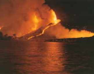
Beerenberg received little attention after this, not being designated as an actve volcano. But on 18 September 1970, that changed. It started with a magnitude 5 at the north side of the island. This was followed, probably immediately, by a large eruption. The eruption was not seen by the local observers at the weather station, who were affected (as usual) by snow and fog. In fact, they did send out a patrol (by car) to see the effects of the earthquake, but the patrol did not see anything, in part because they went to the northwest corner (where there was a road) while the eruption was in the inaccessible northeast. The eruption cloud was subsequently found on satellite images. In southern England, the following days showed volcanic colours in the twilight skies: the ash and dust had spread across the Atlantic.
On 19 September, there was another felt earthquake on the island. The pilots of a plane which had taken off from Jan Mayen on the way to Norway saw the mushroom-shaped eruption cloud – although they did not recognize it as such. Early the next morning (3 am, 20 September) a Japanese plane saw a cloud rising to 10 km, finally recognized it for what it was, and reported the eruption. They were shortly followed by similar reports from other aircraft. There may have been further explosions between 18 and 21 September: it is hard to tell with such an obscure(d) volcano! The weather station, 30 km away, was quickly (and briefly) evacuated, although in hindsight this had not been necessary.

Source: Birkenmajer 1972, https://geojournals.pgi.gov.pl/agp/article/view/9850/8385. The symbols in the top right show the eruption sites of 1970.
On 21 September, investigators arrived and finally found the eruption in progress. The eruption occurred in four locations along the northeast coast, over a distance of 5 km. Lava fountains were 200 meters high and the lava flowed in four streams in to the sea. The lava extended the shoreline by 1 km, and the depth of the sea reduced by 100 meter. It seems, however, that this was not just due to the lava. There may have been a collapse along the coast, or perhaps a rotation of the coastal block with the on-land part sinking and the part lower down rising. The lava flows lasted until mid-October – it may have continued until December but the weather was too poor (or rather too normal) to investigate.
There was a final observation of smoke on March 16 and 23, 1971, in both cases after an earthquake. On the second date, there was also some fumarole activity on the southern side of Beerenberg. With that, the eruption had ended. The lava volume is estimated at 0.5 km3, but this seems quite uncertain.
A new earthquake swarm occurred in January 1973, with more than 300 detected events, which resulted in an explosion crater next one of the 1970 eruption sites which was found in the following summer. Widespread fumarole activity was seen in the area that summer. However, whether this constitutes an eruption or an after-event is not so clear. Many sites list an 1973 eruption, and one AI even tried to tell me it was enormous (being confused with 1970 – it is all the same to an AI), but this is all it was. It seems better to describe it as a late hick-up.
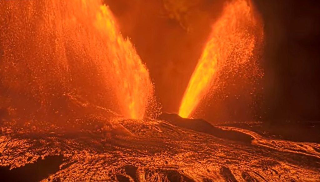
Beerenberg was by now thought to erupt on average around once per century. Thus, 1985 brought a surprise when on Sunday 6 January an earthquake swarm with several high M4 events heralded a new eruption. It happened at extreme northeast corner of the island. The weather was clear enough that a red sky could be seen from the settlement, 30 km away. Commercial planes flying overheard early the next morning reported seeing lava flows. A plane was arranged to fly from Reykjavik to observe the eruption. It arrived in the afternoon, just after the eruption had ended. A photo from this excursion is shown below. The observers saw three new craters, one of which emitted the ash plume, while a white plume at the coast showed where lava had reached the sea. But the craters no longer had lava flowing out of them, although there was still lava visible inside the craters. The total lava volume of the eruption was probably no more than 0.01 km3.

Source: Pall Imsland , Journal of Volcanology and Geothermal Research, 28 (1986) 45–53 (sorry, paywalled – reading is strictly prohibited.)
Beerenberg volcano is in fact fairly active, although not at the level of some of the Icelandic volcanoes. Ancient eruptions are recorded in the Greenland ice. Fumarole activity in the crater is common, but the central crater is probably currently blocked by a cold plug, and all recorded eruptions have been from fissures in the flanks. But there have been holocene eruptions from the summit and they could occur again. Sor-Jan has not been active in the holocene and is probably a bit like the Reykjanes peninsula – active when it wants to, quiet when it doesn’t, and without any central volcano.
The 1970 eruption (T. Siggerud)
De-spotify Jan Mayen
Why is Jan Mayen’s Island here? It is sitting at the end of a spreading centre but those normally remain submerged. Iceland is a counter example where a spreading ridge rose above sea level, but that is attributed to a hot spot. It has therefore been suggested that Jan Mayen too has a hot spot underneath it. This hotspot even has its own wikipedia page which neatly summarizes the evidence for it – it is a very brief page! A mantle plume has been mentioned, similarly with limited evidence. There is an indication for one underneath Iceland and underneath the Kolbeinsey ridge, but not underneath Jan Mayen Island. The sea floor bulge that should accompany a mantle plume (present around Iceland) is absent from Jan Mayen. That leaves the explanation for this isolated volcanic spot up in the air!
Jan Mayen’s location is part of the mystery. It lies at the place where the Jan Mayen Ridge connects to the Mohn’s Ridge. One is a sliver of Greenland’s continental shelf, the other is an oceanic spreading centre. Which one does Jan Mayen belong to?
Drilling has shown that the Jan Mayen Ridge consists of sediments (not unexpectedly) without lava – there are some tephra layers but these may come from Jan Mayen. In contrast, Jan Mayen Island is mainly volcanic. Any sedimentary basement lies deeply buried. The volcanic nature shows that Jan Mayen Island is part of the Mohn’s Ridge, more than it belongs to the Jan Mayen Ridge. This relation is strengthened by the fact that its volcanic activity is stronger in the north, closer to the Mohn’s Ridge. The fissures show the same relation, as the lines of the fissures are along the same angle as those of the Mohn’s Ridge.
But that begs the question why there is a major volcano on the Mohn’s Ridge above sea level, when the rest of this ultra-slow ridge has little volcanic activity. A finger can be pointed at the Fault Zone which terminates the Mohn’s Ridge, and which may allow magma to come up more easily. Another finger may point at the continental crust of the Jan Mayen Ridge which ends here as well but from the other side. This continental block may channel magma around it towards Jan Mayen Island. The lava production of Jan Mayen Island is about three times higher than a mid-oceanic ridge of the same length would do. Channeling of magma produced over 100-200 km length would explain Jan Mayen Island and its Beerenberg volcano.
Beerenberg may be the best protected volcano in the world. It also remains remarkably unknown and understudied. Perhaps these two are not entirely unrelated: it may be difficult to study a volcano you are not allowed to visit. We can be reasonably confident that the next eruption will come as a surprise.
Albert, October 2025


“…the tallest mountain in the world with a Dutch name!” LOL!
Another fascinating article Albert! I wonder if you cogitte to gather them all in a book!
“Beere” either applies to berry or bear. After the extinction of Polar Bears it only applies to arctic berries. I don’t know the berry variety of Beerenberg und if there are healthy ones. Norwegian Wikipedia says that on the island are some endemic varieties of Taraxacum https://www.gbif.org/occurrence/1702069947
Definitely the polar bears. The berries don’t grow on the mountain!
Like Albert hinted at, at the time it would very likely refer to the polar bears. It’s probably also the tallest mountain with an official Dutch name in an old spelling (“beer” + suffix “-en”). According to current spelling rules, it would be “Berenberg” instead (in plural form, “beer” loses its second “e”). Both translate to “Bear Mountain”.
Yes, this is true. The Dutch call bears “Beer”, while the Skandinavian word for “Bear” is “bjørn”/”björn”, also a popular name for humans. However, it’s linguistically interesting how three words can be so close: beer, bear, berry.
Very common, in fact, because the words are older than the writing. Another example is white and wide. Pronunciation was different, including whether the vowel is long or short. There are many ways in which words differ which do not show up well in spelling. Or, in the case of English, the spelling says nothing about how it is pronounced
It’s a fascinating part of the world. I read Alistair MacLean’s “Bear Island” when I was a kid, and both that island and Svalbard have coal deposits – which means they were once warm and lush!
On the south, not too long ago some geosciences people mapped a whole bunch of volcanoes under the western Antarctic icecap.
New volcanoes identified under the West Antarctic Ice Sheet (2017)
If that is true it could be that there is a volcano as far as 83° south. It’d be very interesting if one of those volcanoes could erupt through the kilometres of ice sitting on it.
Before Pleistocene both Arctic and Antarctica had more or less Temperate climate. Maybe the current climate warming leads to a climate like this in the Arctic Region again without significant glaciers, but with many new woodlands which are a possible source for coal creation.
As an aside, Jan Mayen Island did not have major glaciers during the ice age. The climate at the time at this location was too dry. Obviously, this is completely irrelevant to coal formation.
I wonder if there is any evidence of ash or effusive layers in any of the ice cores that have been the subject of CO2 studies.
North vent overflows started just after 7:30pm HST
Fountaining tonight?
This might be it! Seems like low fountaining has begun from the north vent, 7:45pm HST
Still going. Just waiting for fountain to go higher now.
Yeah it’s on now. Tremor is increasing and I think tilt just switched to deflation…
where, when webcam, pics ….
busy day, will likely miss.
(sigh)
V1cam:
https://www.youtube.com/live/tk0tfYDxrUA?si=9z6iNRp8pWIQqwgm
V2cam:
https://www.youtube.com/live/fiyttmA7YkA?si=FYUQahO5zxbJnahZ
V3cam:
https://www.youtube.com/live/BqmpkUdMtyA?si=Ylxy8u3ajNBW2Euo
thanks tomas ….
Wow.
The devil … or friendly Pelee has two lava eyes 😉
The glowing lava shows the growing shield structure well that surrounds the spatter cones.
The south vent is a truly colossal fountain in the V2 cam right now.
V2 cam is insanity at the moment!!
(K2 camera, static)
Fountains are definitely taller than anything before them… for sure.
(B1 Cam, static)
Hopefully a somewhat better view. There is no doubt that there were rootless lava flows at the caldera rim because at the V1 camera, lava is still falling into the caldera.
I hope that Big Island News does/gets a good video again. Their video summary often supplied the best views and moments of the episodes.
However, there is still no visible tendency towards any continuous eruption. The episodic eruption appears to continue for a while.
HVO is providing commentary now, even though they are officially furloughed. Record fountain height confirmed!
Kilauea Message 2025-10-17 22:11:14 HST
Record high fountains for this eruption, nearly 1500 feet high. https://volcanoes.usgs.gov/hans-public/notice/DOI-USGS-HVO-2025-10-18T07:33:48+00:00
Kilauea Message 2025-10-17 21:31:41 HST
South vent has topped 1300 feet (400 meters) and north vent is about 1100 feet (330 meters), a record for two fountains during this eruption!
Kilauea Message 2025-10-17 21:19:36 HST
Both the north and the south vent are over 1000 feet (300 meters) with the south fountain about 1150 feet (350 meters) high.
Kilauea Message 2025-10-17 21:10:21 HST
Both the north and south vent fountains are now 600-700 feet (200-230 meters) high. The eruption cloud above the dual fountains is now over 16,000 feet (5000 meters) above ground level or 20000 feet (6000 meters) in elevation.
Kilauea Message 2025-10-17 21:04:48 HST
Fountains from the south vent began at about 8:50 pm HST and have grown rapidly to over 150 feet (50 meters) in the last 15 minutes. Both the north and south vents are feeding large flows on the the floor of Halemaʻumaʻu crater.
Kilauea Message 2025-10-17 21:01:23 HST
Episode 35 continues from the north vent with fountains about 500 feet (150 meters) high. The north vent fountain is currently angled at about 60 degrees to the north east, similar to episode 34. Minor fountaining from the south vent.
Kilauea Message 2025-10-17 20:25:30 HST
Episode 35 fountains began from the north vent at about 8:05 pm HST and fountains current are over 300 feet (100 meters) high. Fountains are expected to continue to grow and probably begin from the south vent as well.
Kilauea Message 2025-10-17 20:06:57 HST
Continuous precursory overflows began from the north vent at 7:28 p.m. HST October 17. Fountains are 30-50 feet (10-15 meters) high. Tremor is increasing and tilt is dropping, episode 35 fountains should start soon.
Kilauea Message 2025-10-17 17:50:26 HST
Precursory overflows (31 total) of degassed lava continue from the south vent along with spattering in the north vent. The onset of episode 35 fountaining could happen anytime between now and Tuesday with Saturday or Sunday most likely.
Kilauea Message 2025-10-15 21:20:58 HST
Nearly continuous strong glow is coming from both the north and south vents. Intermittent spattering in the north vent began just after dark. Seismic tremor indicates sustained tremor changed to irregular gas pistoning in the last 2 hours.
Kilauea Message 2025-10-12 21:47:52 HST
Short spatter bursts were observed from the south vent at 9:09 and 9:32 pm HST and at 9:29 pm HST from the north vent. These indicate that magma is high in both vents and spattering events should increase over the coming days.
Meanwhile, looking at the V2 Camera, you could start to see the ne crater walls of what I presume to be a cinder cone. By this point, Pu’u’halema’uma’u has offically existed into being (and correct me if that doesn’t sounds good…).
The fountains are 500m high, the massive lava flash flood in the caldera looks as if the rate of the current episode exceeds all previous ones.
https://bigislandnow.com/2025/10/17/yes-you-are-seeing-double-kilauea-erupts-with-twin-lava-fountains-within-an-hour-after-episode-35-begins/
https://bigislandnow.com/2025/10/17/kilauea-reaches-new-heights-as-lava-fountains-of-episode-35-burst-to-almost-1500-feet/
But the lava fountains are already decreasing. The episode will likely end before sunrise. Deflation has reached a deeper level than during the previous episode.
A V2 view
Albert, you say that “Jan Mayen Island can be seen as a 50-km long volcanic fissure”. This is 42% of Mauna Loa’s length. So it is a long volcano, if we regard it as a one volcano show.
The shape of Beerenberg resembles a bit Snæfellsjökull, but the behaviour is different, as far I can compare them. Is the productivity comparable?
And suddenly, the eruption ends. It is amazing to see how quick it went. The south vent went first, two minutes later followed by the north vent. I think the vents are at around the same height, so this suggests that the north vent is closer to the magma source or conduit. At least during the fountaining phase, because during the piston-overflow phase the south vent responded quicker and earlier. That may have to do with the north vent being partially blocked at first by the tephra sliding down the slopes. The south vent is less affected by that. Just a guess.
After the south vent ended, there were tall hydrogen flames coming from vent for a minute or two. It ended at about the time that the north vent quit, but the north vent did not show any flames as far as I could see. Anyway, it suggests that the south vent ran out of magma before it ran out of gas.
Have the gases been spectrally analysed?
Would be nice to be sure they are in fact hydrogen, lots of things can produce blue flames.
True! Suggestions welcome.
Sulphur burns with a blue flame
Methane also.
Theres probably not really anything else it can be really, only H2 is stable as a molecule among gases that are reactive with oxygen at 1200C. Theres also a lot of water at Kilaueas summit and in the humid atmosphere. The flames also have no real colour, only the spectral colour of trace elements in it, not particulate matter from incomplete combustion.
At this point its probably just a slight difference in the length and geometry of both vents. There are two very stable and robust conduits, its unlikely they join at any point above the magma chamber. In effect there are basically two separate simultaneous eruptions right now. Its likely they will merge eventually but not soon it seems.
The south vent overflows though, those are new, its rarely done precursory activity and nothing like as strong. Its not all that unlikely the apparent start at the north vent was just because the south vent had finished a gas piston and needed to rebuild, rather than anything fundamental to which vent is or isnt in control.
Its also crazy that the north vent was far from weak, it almost broke its own height record despite the south vent being even stronger. Something has definitely changed now
The most equatorial volcano, would that be Wolf?
https://www.volcanocafe.org/the-wolf-the-tortoise-and-the-plume-a-story-of-the-galapagos/
That will be hard to beat! Anyone with a better (or equal) suggestion?
Cayambe perhaps? I heard somewhere that its glacier straddles the equator.
Well, Volcan Wolf (with its coordinates: 0°0′00″N 91°20′00″W) certainly beats Pichincha (0°10′16″S 78°35′53″W), which, I think, still is the “most equatorial volcano looming over a big city”.
Reventador is the most active volcano close to the equator: 0°4’39 S
https://www.igepn.edu.ec/
BTW, there’s some otherworldy beauty in that photograph of Beerenberg. Imagine being a sailor who saw it for the first time!
An excellent read. Thank you!
Aside from widening the graph a bit and decreasing font size slightly to accomodate new episodes, I’ve also changed the method of how I calculate the volume per µrad. Previously, this was just the product 5 million m³ divided by 13 µrad (i.e. a rounded 384 615 m³/µrad), taken from episode 18. This is now the average of all episodes where the HVO stated both volume effused and µrad lost, with a maximum difference of 0.5 µrad from the number I get from pixel-counting UWD. Above that, to me, is too much a difference to explain by the obvious inaccuracies of calculating from a graph without access to the data, and what the HVO can get from their raw data (and rounding that to the nearest 0.5). It is, however, unfortunate past daily updates, information statements and VONAs have gone missing (at least through a direct link – perhaps related to the shutdown?). I therefore was only able to obtain, aside from episode 18, data from episode 24 onwards. The HVO began issuing VONAs to announce episode progress with this episode and are (fortunately) still viewable on their volcano notices page.
The average volume per µrad across these episodes (with the outliers removed) is, as of episode 35, a rounded 364 220 m³/µrad, or just over 20 000 m³ less than the old number. This has the obvious result that the resulting numbers have also decreased. The absolute recharged and effused volumes are at most 0.5 million m³ lower than before, for example, and the recharge rate is about 0.5 m³/s at most lower than before (with ahead of episode 2 an outlier with a “loss” of 1.6 m³/s, though the – still – large number is in large part due to the drainback which occurred). Another interesting tidbit is that, in terms of effusion rate, no episode went over 200 m³/s until episode 34, the previous highest (episode 23) just shy of the 200 mark, 195.2 m³/s. The bonkers 450.5 m³/s of episode 34 is now a bit less bonkers, but still good for 426.6 m³/s.
Though such a significant change might seem bad, to me it’s an improvement in the sense of that these new numbers are closer to HVO’s numbers. If anything, I did myself a disservice by sticking to one number of one episode, rather than switching to this method of averaging the volumes out over a longer time period. Without further a-do, here’s the revised (and updated to episode 35) graph:
Numbers of the past five episodes, rounded to the first decimal (again, keep in mind these numbers aren’t comparable with earlier numbers I shared in earlier comments on Kilauea):
* E31: recharged ahead 8.1 million m³ (22.2 µrad) at 5.8 m³/s on average | effused during 8.0 million m³ (21.9 µrad) at 172.2 m³/s on average.
* E32: 7.1 million m³ (19.4 µrad) @ 8.1 m³/s | 9.2 million m³ (25.2 µrad) @ 189.8 m³/s
* E33: 8.6 million m³ (23.6 µrad) @ 6.1 m³/s | 6.2 million m³ (16.9 µrad) @ 191.0 m³/s
* E34: 6.7 million m³ (18.4 µrad) @ 6.7 m³/s | 9.5 million m³ (26.0 µrad) @ 426.6 m³/s
* E35: 8.9 million m³ (24.4 µrad) @ 6.2 m³/s | 10.6 million m³ (29.2 µrad) @ 396.5 m³/s
What’s interesting, is that of the past five, three (32, 34, 35) effused significantly more than they recharged ahead, with two of these in a row. In previous instances, the effused volumes of episodes thereafter wouldn’t be significantly out of line with recharged volume, or would’ve even compensated for this loss by recharging more than they effused, but it’s odd, to say the least, this happened so closely-spaced. Granted, it could be a red herring, as this has happened previously between episodes 1 to 4 (inclusive) and episodes 8 and 9.
In the same time period between episodes 30 to 35, tiltmeters UWD and SDH have “disconnected”, with UWD inflating significantly less than SDH; in fact, SDH “over-inflated” in this time period, the start of an episode coming well past the previous episode’s starting tilt level. I recall a comment earlier theorized the lower magma chamber has begun to play a more prominent role in the eruption when this was first noticed, and the chamber measured by UWD more the role of transportation. With this set of episodes it definitely seems the comment was on the right track.
Hopefully HVO staff have continued to collect samples, as I’m curious whether this decoupling of UWD and SDH (and thus the possible greater role of the lower chamber in the eruption) has also resulted in a magma composition change.
Thanks. Sadly the image that you embed is blocked from viewing. I have the massage ;content not available in your region’
Odd. I’ve also got a Google Drive link, see if that works for you (and others who may have the same issue): https://drive.google.com/file/d/1YLXgLfzuSLzviXd68s1c8RSlbEq5-lg8/view?usp=drive_link
I have replaced the link in your comment with this image
Thank-you for your calculations J.O.!
The episode was relatively short with 7.5 hours and ~6 strong hours. Between 9 p.m. and 3 a.m. the deformation fell from 10 to -15 microrad. This applies to a speed of 4.2 microrads per hour. 4.2 microrads apply to 1.53 million m³ per hour in your calculation. For the main six hours of the episode this means a volume of 9.18 mllion m³.
Episodes 29 to 32 lasted for 12-13.5 hours. They had nearly double time for less absolute volume.
F.e. Episode 30 erupted 7.9 million m³ in 12 hours. This applies to close to 4 million m³ in six hours. It means that episode 35 was 2.3 times faster than episode 30.
Episode 34 also was six hours short like 35. So there is a tendency towards shorter episodes with higher rates.
Theres also the fact the north vent hasnt actually declined, at all. It was only 10m off its record height, just totally overshadowed by the north vent.
Until E34 and E35, I cant remember both vents really going together in a way that compares.
During the eruption it looked like a dragon with lava eyes that push out lava fountains. The eruption was very symmetric, it had a high aesthetic value.
Video Summary of the episode:
Thanks for the update!
Since E18 theres definitely been a steady trend upward in volume, regardless of intensity.
As of now after E35 the volume is 187 million m3, and total volume since 2020 is 391 million m3, so basically half way to refilling the 2018 caldera
It is impressive, and may well lead to re-establishment of the wider lava lake of the 19th century. Note that the GPSs away from the caldera (OUTL, AHUP) show minor deflation. The eruption is draining the deeper magma: art is erupting faster than it is being replenished (not surprising at current eruption rates). That may even be why the situation remains stable. The episodes are larger and less frequent, but there is no indication that the rifts are re-opening. I hope this continues: it is a wonderful spectacle.
The subsidence at OUTL and AHUP are probably not magma related. OUTL is moving slightly south, and AHUP is static north/south, if it was magma it would be northward movement. SDH has shown overall uplift recently.
SDH does not have a gps and can’t show up / down. It is a tilt measurement.
Its showing the summit is tilting the ground outward more than the eruptions are releasing, meaning overall accumulation of magma. The magma system is inflating it could just be a local subsidence ring around this, or movement in the faults.
Spitsbergen is not entirely non-volcanic though. It has the pleistocene Sverrefjellet, unless you meant that statement only applied to the present day.
Many places have an interesting volcanic history! Going back far enough, perhaps every place does. But yes, the post is about currently active volcanism.
How cold does Jan Mayen get in winter? its a very oceanic climate I woud not be supprised if Chicago and even Georgia acually gets MUCH colder in winter due to its rather almost Russian continental climate yet being much warmer than Mayen in summer …
Jan Mayen is at the tip of the Gulf Stream, so warmer than it would otherwise be.
The thermohaline cycle is fascinating. I’ve tracked it, it circulates from the North Atlantic all the way to the Pacific and back again over many decades. The abyssal current velocities that have been measured are consistent with the period of the cycle.
Jan Mayen sees the gulf stream on its east coast but the cold Greenland current on the west. The latter is also called there Jan Mayen Current, which gives a hint. It has changed. The Odden Icetongue, a 1300 km long region of surface ice which used to form in it over winter in t he Greenland Sea northwest of Jan Mayen, and which was the main source of drift ice in the region, disappeared around 25 years ago. This area is one of the places where the deep return of the world-wide thermohaline circulation forms: the Greenland Deep Water is in a way the counterpart of note Gulf of Mexico. With the warming of the surface waters, the cold water doesn’t sink as deep anymore, at least in this region
Impressive that Beerenberg is with 2277m also the highest volcano of northern Europe, higher than Iceland’s highest volcano Öræfajökull with 2110m. Added to this Beerenberg has a submarine base, while Öræfajökull sits on Iceland’s plain.
I thought for a moment you meant submarines 🙂
Dutch Wikipedia tells the story how Beerenberg was labeled: “De naam is begin 17e eeuw door Nederlandse walvisvaarders aan de berg gegeven, vermoedelijk vanwege de ijsberen die zij rondom de berg signaleerden.”
“ijsberen” = Ice Bear (Polar Bear)
Pretty much the entire naming convention for the frozen parts of our planet are determined by if polar bears are there or not lol. Even the term ‘arctic’ literally means bears are here. Antarctica just means ‘no bears here’ but also kind of just ‘opposite arctica’ either way though.
True – although one may argue which bears the Greeks were thinking about! The traditional explanation is that it comes from the Ursa Major constellation which is possible as from Greece, it circles from near the zenith to the northern horizon. Ursa Minor is the other option: 2300 years ago, one of the stars of this constellation was nearest the pole (not Polaris). But I’ll go with Ursa Major. I doubt that the Greek knew about polar bears.
English is full of Greek loan words though, lots of them, especially in scientific literature. So it might be Greek origin but much more recent in the age of exploration.
The first mention I am aware off is in Ariototle’s Meteorology. He writes ‘the regions below the Bear are uninhabitable because of the cold’. The word for Bear (Arktos) is also one the Greek ‘Hora’ gods, each in charge of one hour of the day. Arktos was on charge of midnight and the constellations. That puts the zodiac in its place!
Goodness me.
I had not realised that precession was so fast.
After polaris, what will be the next polar star (OK might be a long time before there is one)?
The Pole Star (Polaris) only acquired this name in the 15th century. There was no star at the North Pole before that. The sudden travels across the Atlantic by Basque fishermen and later Columbus was made possible by the improvement in ships, but aided by the improvement in navigation from Polaris. Polaris will be closest to the pole in another 50 years or so. The last time before that that were was a usable pole star was 3000BC (quite faint but the skies were darker in those days), and in the future there will be one around 4000 AD – if anyone is still around to use it! When our constellations were first named (around 2500 BC), there wasn’t one.
supplementary….
when will polaris be too far off north (say 5 or 10 degrees) to be useful?
Will it return in 28,000 years (or whatever one precession cycle is)?
5 degree is quite far for navigation, as it means a 10 degree variation during the night. That would have been the case around 1250 AD or so. Polaris will come back to the pole in 26,000 years, although not exactly the same location as the star is moving a bit: buy then it will have moved by about 0.3 degrees.
As for equatorial volcanoes, if i’m not wrong he equator line passes through the island of Sao Tome (and it’s volcano), as well as the Eburu system south of Menengai. And Lake Toba!
Quake at big island
43.46 km (27.00 mi)
Magnitude: 4.15 M
Date: 2025-10-19 14:26:08 (local)
2025-10-19 18:26:08 UTC
Age: 0.05 days
Distance From: 17 km NW of Kalaoa, Hawaii
On Etna they found a correlation of quakes useful for predictions: https://www.livescience.com/planet-earth/volcanos/scientists-discover-new-way-to-predict-next-mount-etna-eruption?fbclid=IwY2xjawNivpNleHRuA2FlbQIxMQABHq6aG9eTZgAJK_rJnmAGWgo0UrSD18zv4-ZTeEESei6eLCSdn_2J6CSmrxwK_aem_co9fNdfAqks9mb2bylzTAg
They used a parameter “b” that “describes the ratio of low-magnitude to high-magnitude earthquakes. This ratio can change as magma rises through the crust to the summit of a volcano”
“by tracking the b value over time, it may be possible for researchers to follow the movement of magma through the deep crust to the first storage zone, up from there to the intermediate storage system, and up again to the shallow storage zone. This method could help experts estimate the timings of eruptions at Mount Etna.”
This is quite interesting – TLDR version: better detection and plotting of low magnitude quakes with the help of AI
https://www.livescience.com/planet-earth/volcanos/ai-reveals-hidden-ring-fault-that-is-unleashing-earthquakes-at-italys-campi-flegrei-volcano
A swarm at Katla today with the largest magnitude a 4.5. Seems very shallow for now and not magma related.
Does seem to be an awful lot of big quakes for this just to be standard seasonal ice quakes?
A very big Jokulhlaup about to break out maybe?
“No changes are seen in conductivity or water level in rivers flowing from Mydralsjökull.” update from imo. So at least for now no further signs of a run…will be interesting to see how this plays out.
Winter descending over Iceland the clouds gather, the darkness grows and the snow start to fall from grey skies
Ah, that read almost like a poem! Reminded me of this old Irish pearl:
WINTER
Scél lem dúib: I have news for you:
dordaid dam, the stag bellows,
snigid gaim, winter snows,
ro fáith sam. summer has gone.
Gáeth ard úar, The wind is high and cold,
ísel grían; the sun is low;
gair a rrith, its course is brief,
ruirthech rían. the tide runs high.
Rorúad raith, The bracken has reddened,
ro cleth cruth, its shape has been hidden;
ro gab gnáth the wild goose has raised
giugrann guth. his customary cry.
ro gab úacht Cold has caught
etti én; the wings of birds;
aigrid ré — it is the time of ice —
é mo scél. these are my news.
With slightly different translation to English: https://irishfolklore.wordpress.com/tag/irish-poem/
The Polar Vortex and west wind system could be disrupted soon and lead to cold weather in parts of Europe and USA: https://www.severe-weather.eu/global-weather/polar-vortex-early-disruption-brings-colder-weather-winter-2025-2026-united-states-canada-europe-fa/?fbclid=IwY2xjawNkEglleHRuA2FlbQIxMQABHpNVD0nex1AGc-BaNkCtI1wXur8Mrp7OxSyrCmsWWBp5V7NLVVUwae1bYzj9_aem_5We35XXQsljG9feNC9Nryw
On one hand a unusual weather situation like this leads to cold pattern of weather systems. On the other hand the source of cold air may be too mild. Added to this climate warming leads to higher temperatures in polar regions in general, so they can’t supply really cold weather in other parts of the world. Cold weather pattern may turn out too mild compared to 30-50 years ago. The same pattern that once brought -20°C, may mean -5°C now. But the fools who doubt about climate change will use the -5°C as a reason to doubt about climate warming, because “it is cold”.
Might there be some low-grade unrest at Hokkaido-Komagatake?
There are some tremors a bit SE near Shikabe.
There is a fault near Hakodate, but it doesn’t appear to extend this far north.
Mosquitoes have now colonized Iceland! and they been seen there some years before as well by friends that I haves there. With plenty of prey souch as rats, birds, cattle, reindeer, horses and good larvae habitats deep lakes, bogs and with Icelands relativly mild winters there is no reason that these insects should not be able to live in Iceland. Mosquitoes thrive in much much colder conditions elsewhere anyway
https://www.icelandreview.com/news/scientists-confirm-first-mosquitoes-found-in-iceland/?fbclid=IwZnRzaANkGpJleHRuA2FlbQIxMQABHn7YG3FSOMoro_00AIyGejjm-_v98hp2l5xgAimTuba3fnzEWZdtRiL29rU6_aem_kBvWX5OtCyZ7AzNGjhfKMA
Mosqouitos have been thriving on Island for millenias. The big northern lake ”Myvotn” translates to Mosqouito water!
Wikipedia says the name translates as “Lake of Midges” not Mosquitos. The specimen found was Culiseta Annulata which is a mosquito not a midge (or midgie in Scotland).
I have no mosquitoes, because I have these guys.
They eat all the mosquitoes.
That didn’t quite work. Another photo here, from my yard. They are noisy miners (Manorina melanocephala). They eat all the spiders too.
This might work.
Apology to Albert and Hector, I’m testing out what the blog allows codewise.
Nope, didn’t work. Ah well. The url plus the “?size=1024” add-on gets a photo that you can actually see, but requires a bit of editing in the address field.
Quietly pleased it isn’t a monster-size spider after googling it’s latin name.
They often arrive with a small green spider.
So I give a morsel of white bread and a tiny bit of mincemeat.
Green, red and white. The kids are having Italian food today!
Came across this:
https://watchers.news/epicenter/taftan-volcano-reawakens-after-710-000-years-of-sleep-revealing-hidden-hazards/
A very little known Eurasian volcano. Makran trench is interesting, potentially high risk (M8.5+)
(Credit goes to Private Volcano Tours, video here: https://www.youtube.com/live/5-did9HoDHQ?si=bcIcyHGm67AsRVRq)
Basically a bit late for the news, but there were massive lava falls during episode 35. That’s after the north vent decided to change direction. More of these might happen in the future.
Cool video, there’s really a lot of lava going down those lava falls… Also, the jets of incandescent pumice seem to briefly attain heights of ~600 m (which I think HVO does not count as fountain height because of the short-liveness), with a level of fragmentation that is rarely seen from Kilauea, producing light basaltic pumice.
That is by far the tallest of this eruption and it’s beating Iki and Maunaulu in terms of episode count, but I have a feeling that, once episode 36 hits (forecast on Halloween to Nov. 4), the fountains might get taller than this.
E36 is gonna be over 500m sustained
Hopefully the annoying orange shutdown bs is over by then so we can get a look at the lava on the rim and what it looks like.
Also on an old video of 1959 the narrator said tbe 1959 eruption was roaring like a jet engine, but they had no recording equipment. Now we know what it sounded like 🙂
Does this tendency towards taller lava fountains mean that the magma has to overcome more difficulties to erupt again? It looks as if higher pressure than during earlier episodes is needed to begin an episode.
Are the episodes going to end after one year around Christmas or would you expect that more episodes will continue 2026?
I think Chad mentioned something about this eruption continuing past 2026 and towards 2028, maybe further. I my opinion, based on the observation between the previous few fountains and Ep. 35, they could get taller and continue building the cinder cone at the caldera rim. In terms of episodes, it has beaten Maunaulu and Kīlauea Iki combined, but not Pu’u’o’o yet. That’ll take about 9 more episodes to beat it in terms of fountains and 26 to beat the overall number.
Zach if it keeps going at the current rate it will fill tbe 2018 caldera in about August 2027, likely in reality overflowing the rim earlier as the vent have raused much faster than the rest of the floor. I guess there have already been flows on the rim, their extent still unknown until HVO can be staffed again…
I dont see this stopping brfore doing 9 more fountains to be honest, it could easily do this for years. Pu’u O’o was going very strong and failed only because its conduit was directly in a rift zone, and about half the episodes actually had ruptures that failed to kill the fountains, it took a while. The current vents are actually caldera ring fault vents and not on the SWRZ fissure swarm, adjacent yes but not directly connected. Probably… But the E30 fissure would have gone past the SWRZ cracks and didnt enter.
I really hope HVO can do sample analysis for composition. As the fountains ended they basically became strombolian, the lava is so gas rich its hard to tell what is the liquid fountain and what is more solid pumice.
This must be a new batch of very hot and fresh magma, with no time to degas, drawn up by low pressure of an open vent..
One for Hector
https://www.nature.com/articles/s43247-025-02797-x
Thanks! It’s good to have confirmation.
Following on from Jesper’s comment, birds and volcanoes.
Birds played the biggest role in colonisation of Surtsey (RÚV, 21 Oct)
I have a lot of friendly birds in my yard, it has been a hobby of mine. The pied currawongs (Strepera graculina) are especially fun, and I can offer them a piece of mincemeat – whereupon they go crosseyed, then after a short while regurgitate a mass of fig seeds. Once sorted they accept the piece of meat. As a consequence I have to keep on exterminating newly sprouted fig trees in my yard.
How fruitful is raw volcanic soil for seeds? There is no humus. Seeds have to grow on raw tephra or lava. Are there a number of pioneer plants that can cope well with volcanic soil?
“In USDA soil taxonomy, andisols are soils formed in volcanic ash …”
“Because they are generally quite young, andisols typically are very fertile except in cases where phosphorus is easily fixed (this sometimes occurs in the tropics). They can usually support intensive cropping, with areas used for wet rice in Java supporting some of the densest populations in the world. Other andisol areas support crops of fruit, maize, tea, coffee, or tobacco. In the Pacific Northwest US, andisols support very productive forests.”
says https://en.wikipedia.org/wiki/Andisol
Regarding growing tomatoes on Surtsey, isn’t it a bit too windy and cold place for that?
Tephra is good stuff. I read this tome:
Ten Thousand Years of Cultivation at Kuk Swamp in the Highlands of Papua New Guinea (2017)
In short, when volcanoes erupted and deposited ash the locals could grow food. Probably, and especially, because of the potassium in the ash. The tephra and ash mainly came from Long Island to the east.
From the comment above phosphorus may be more important, particularly if it is freely available (pH <7). It binds very strongly to calcium and becomes unavailable even if at quite high apparent concentrations.
I suspect many ash deposits are rather high in available phosphorus.
One of my favorite stories is the one about the scientist who planted tomatoes on Surtsey. It wasn’t really intentional and he used the same method as the birds.
The Mesoamerican origin of tomatoes has a lot of volcanic soils. Maybe the original wild tomato was adapted to sand or tephra. Mexico has usually subtropical climate, so the original tomatoes were likely adapted to semi-arid conditions. They may have an opportunity to grow in Iceland’s volcano desert(s).
too cold in Iceland you woud only end up with a very tired low shriveled plant in the end of the summer
https://www.volcanocafe.org/the-new-lagoon-and-icelands-thor-adventure-park/comment-page-1/
Dont forget the live Dinosaurs park addition … infused with lion, mole, and Trump and Putin DNA..
About the Laacher See volcano in my neighbour’s backyard (I live in the Netherlands):
* https://www.volcanoes.de/2025/10/10/laacher-see-volcano-unusual-earthquake-swarm-detected/ “Laacher See volcano: unusual earthquake swarm detected October 10, 2025 by Marc Szeglat”;
* https://www.volcanoes.de/2025/09/26/laacher-see-volcano-study-proves-magma/ ”
Laacher See volcano: Study proves Magma September 26, 2025 by Marc Szeglat”.
More about this, see https://essopenarchive.org/doi/full/10.22541/essoar.175827276.61044315 “The upper crustal structure of the Eifel volcanic region (southwest Germany) from local earthquake tomography using Large-N seismic network data”.
The mysterious Comet C/2025 A1 is heading our way, passing even closer than the Moon. This ancient traveler from the far reaches of the Solar System hasn’t graced our skies for nearly 15,000 years. And just wait until the far future Gliese 710 star passage through outer solar system throws millions of comets towards Earth due to the ort cloud distribution
I heard this
—–
The “C/2025 A1 comet” story is completely false
Posts circulating on Facebook claiming that a comet named C/2025 A1 will pass dangerously close to Earth on October 21 2025 are entirely incorrect.
According to NASA’s JPL Small-Body Database, the object in question is not even a comet.
Its correct designation is A/2025 A1, where the “A” indicates an asteroid, not a comet.
JPL lists it as a hyperbolic asteroid, meaning it is simply passing through the outer Solar System and will not return.
Key facts from JPL data:
Type: Hyperbolic asteroid (not a comet)
Closest distance to Earth (MOID): 4.52 AU → about 675 million km
Closest distance to the Sun (perihelion): 5.35 AU → outside Jupiter’s orbit
Perihelion date: March 12, 2027 – not 2025
No risk, no visibility, no event
In other words, it never comes anywhere near Earth, and it won’t even be visible to the naked eye.
There is no scientific basis whatsoever for the viral claims being shared on social media.
If you see posts about “a comet approaching Earth in October 2025,” you can safely ignore them — they are based on a misreading of NASA’s data and confuse a distant, inactive asteroid with a nonexistent “killer comet.”
Social media once again proving its (negative) value to humanity, I see.
There is an actual comet of non-clickbait proportions currently visible (Comet Lemmon).
Weather conditions and personal schedules have thus far thwarted my attempts to look for it, just like they did with the previous comet, but I will have a chance to search on the 29th.
Then the information on that comet I read was wrong maybe its the stupid AI bots that made up something for profit
Its sad it would have been a spectacular sight if real, but fragments probably would have hit the earth as well at that close.
Please, do check facts before putting catastrophe stories on. VC is not here to distribute false information.
AI is taking over the world so checking other sources about that green comet
Thats saied Gliese 710 is a true thing into the far future
Gliese 710 is likely to come to 10,000 au from the sun in 1.3 million years. For comparison, Pluto is at 40 au. This encounter may scatter a few thousand comets into the inner solar system, may be one per century. Nothing to get worried about, and such encounters are not that uncommon. 200,000 years ago, another star came within 30,0000 au, and another star is currently modelled to reach the same distance as Gliese 710 in 2 million years time. Nothing new under the sun
They estimate 10 visible incomming comets every year.. is that an overestimation in that specific paper that most sources from?
It seems very high to me. See https://ui.adsabs.harvard.edu/abs/2024EPSC…17.1358P/abstract who find that some 4500 comets would be scattered to within the orbit of Jupiter (still a long way from Earth). The encounter lasts 10,000 yr, so that gives one comet per year. But only a few will be close enough to become bright. Of the rest, half is scattered out of the system by Jupiter and half is moved to shorter orbits but that again takes time. Finally, it takes the comets a long time to fall into the inner solar system from that distance. In fact, at a distance of 0.05 au it can take a million years. So the comets arrive at a very low rate. That is the main reason for my estimate of one per century.
visible with naked eye? binoculars? telescopes?
possibly 10 with binoculars …
I think everyone will find this enjoyable – see https://www.youtube.com/watch?v=kyjINIOY2Ls Climbing the highest Volcano in the Arctic – Beerenberg Jan Mayen – with kids
yes, with kids.
It’s an island without the typical Fjord landscape of Norway. The slopes are a more shallow, as a volcano usually builds a mountain. You can also see well the difference between a volcanic landscape and the Caledonian landscape in the fjells of Hardangerviddar or Jotunheimen with crystalline to metamorphe rocks.
The highest peak of the Arctics is on Greenland: Gunnbjørn Fjeld with 3694m high. More than 1km higher than Beerenberg and Galdhøpiggen (2469m, peak of Jotunheimen and Norway). Greenland has many very high mountains. Can they survive a possible melting of Greenland’s ice? Maybe the iceshield has protected the mountains against erosion.
Greenland’s peaks, along with the whole island, will get taller with melting of the ice, due to isostatic rebound. Erosion will obviously increase but will probably take some time to catch up with the rebound.
Gunnbjørn Fjeld is in the region of Greenland which is most close to Iceland. There is a complex geological environment with Paleogene plateau basalts and crystalline to metamorphe rocks. https://da.wikipedia.org/wiki/Gr%C3%B8nlands_geologi#Pal%C3%A6ogen_vulkanisme
Isostatic rebound should trigger magmatism and volcanism, because decompression causes the upper mantle to melt.
Interesting stuff in Reykjanes. A couple of stars in the last 24 hrs, and the inflation graphs have leveled out. The M3s are fairly deep at about 5 km, which might mean the magma is starting to go sideways in a new dike.
Geothermie steuert die Erdbeben am Krýsuvík.
https://www.vf.is/frettir/jardhitinn-styrir-skjalftunum-vid-krysuvik?fbclid=IwY2xjawNmupRleHRuA2FlbQIxMQABHvOIqDEx2UvAx4zhJD2y6tyvVDtQ99LwFppXwB5WRs7Mw7M30ZKqTwzrF1DR_aem_fh3hw2ur3P3qo_V0XYsnOw
I have no expertise on this, but personally I’m inclined to disagree with Professor Guðmundsson. There’s been a slow but constant rock cracking from 7km up in the area, and the drumplots evidence fracturing. The fracturing is rising over time. There’s some sign of steam, yes, but I’m more of the opinion this is tectonic opening and our magma will be easing up in due course.
I’d guess middle of next year we might see this area activate.
Then again, I could be totally wrong. Ahem. 🤔
Let’s see if IMO reports anything about the swarm of earthquakes there in the next few days.
At Katla, there have been a few minor quakes underneath a glacier on the west side of the caldera. Jokulhaups never take that direction, at least not since Eldgja. But I was wondering whether the glacier there was affected.
That spot has been persistently active since as long as I have been watching Iceland. Not sure what it is, but at least it’s nothing new.
Goðabunga?
Looks like a potential location that a lava shield or a small stratovolcano might form.
And Barby has entered the fun with an isolated star. That would be part of the build-up to a Tomas-event.
Yes, it should be primed for the next one now. Microquakes currently happen at a weekly rate similar to levels observed prior to previous M5s, and the time since the last one is now on par with the average time between M5s during the last year. I wouldn’t be surprised if the next one happens within a week from now.
Well predicted! M4.11 @ 16:46, 29/10
Which volcano will be ice-free first, if Vatnajökull retreats fast in future: Bardarbunga or Grimsvötn? Can we estimate how much climate warming is needed to melt most of Vatnajökull?
Probably Grimsvotn because Bardarbunga has a big deep caldera that doesnt seem to have a lake, so its filled with ice. Also significantly higher up. But a major eruption in the next 50 years could easily change that too. It also could mean if there actually is a lake then Bardarbunga might be a major flood risk as the caldera wall bursts,
I see Taftan volcano in Iran is in the news for showing some signs of inflation.
Albert or Hector,
I recently went through some previous series including “Big Basalt Blast” and “The Missing Piece.” It got me thinking about Caldera forming collapses and the different physical forces at play. The roof of the magma chamber is exerting a force downward from gravity of billions of metric tons. A magma chamber from its birth simply starts filling some fractures in the rock as an intrusion. Over time the magma builds pressure and fractures more rock and fills more fractures. If each lets say column of rock providing support to the magma chamber roof and transferring weight into the rock layers below, starts to get eroded and melted away.
Then is this particular feature like a hundreds of thousands of years long game of Jenga as each block of support is melted away, until you reach a point where the jenga tower falls, and the caldera starts to fracture at the edges until it pistons down into the magma chamber and the magma is forced up through ring fractures, trap door ect?
I know depressurization of the chamber plays a role in basaltic volcanoes and other volcanoes, but does the gravity itself as the magma chamber erodes supporting features to the roof of the magma chamber until a critical point is reached, offer a mode of collapse? Do we know if some caldera collapses involved the magma chamber roof collapsing and piston-ing hundreds of billions of tons of rock down, before an eruption?
Is such a mode of collapse, assisted by an extensional basin setup where we see so many Caldera’s in volcanic arcs? With the erosion of the fractured crust into melt leading to fractional crystallization, leading to silica rich lava’s like rhyolite, evidence that the magma chamber has eroded enough of the supporting silica rich rock? Is the 68-76% threshold of silica we see in most caldera forming eruptions evidence that there is a common physical denominator for how much host crust needs to be melted into the magma chamber for it is destabilized enough to form a caldera forming eruptions? Would this mean deeper magma chambers would be more likely to form caldera’s, how much pressure and buoyancy of the surrounding rock and the temperature of the earth would impact this?
It’s an interesting idea. Though there are many complicated factors and little actual data of the event to go with. I did mention something similar for Ioto, where the eventual collapse would come from a gradual approach of the magma chamber to the surface until it blew out violently, although this model had more to do with the intrusion of magma around the edges of the caldera structure rather than melting.
The models for supereruptions include something similar. These have very large magma chambers and the problem is that the roof lacks the strength for cohesion over such a large area. So it will be prone to collapse and this may be what provides the eventual trigger. The magma chambers have to be deep and ideally be located in an area of stretching of the crust, to reduce the pressure on the roof. But over time the roof will weaken.
Thanks Albert!
That makes sense, the Wah Wah Springs eruption got me thinking about it. I think Tallis’s idea was that the eruption itself re-animated a cooling dying magma chamber.
But I imagine like an air piston creating a spark for fire
https://www.instagram.com/reel/DPyhFUyDWqa/
Maybe a roof collapse, rejuvenated the magma.
Thanks Hector,
I know weight of the roof of the magma chamber is a thing, and erosion of support is a thing. But I didn’t know what other factors, buoyancy, pressure, heat, friction, may play a role or how they play out together, but I guess that’s what geophysics is about.
This might be the closest volcano to the equator – quoting from Wikipedia
Cayambe or Volcán Cayambe is a volcano in Ecuador, in the Cordillera Central, a range of the Ecuadorian Andes. It is located in Pichincha Province, some 70 km (43 mi) northeast of Quito. It is the third-highest mountain in Ecuador, at an elevation of 5,790 m (18,996 ft) above sea level.[2]
Cayambe, which has a permanent snow cap, is a Holocene compound volcano which last erupted in March 1786.[1] At 4,690 metres (15,387 ft), its south slope is the highest point in the world crossed by the Equator, and the only point on the Equator with snow cover.
I used Google Earth to try to locate volcanoes on the equator. And yes, Wolf Volcano seems to be the only other one.
So we have a few opinions. Time to come to a conclusion! I might go with Wolf
Time for announcing the winner of the most equatorial active volcano competition! Note, the winner is the volcano, not the person naming it.
Mentioned volcanoes:
Cayambe, Equador. The equator passes through the southern slopes of the mountain. It is an occasional eruptor – may have to wait a few centuries for one!
The summit is 1’30” north, which amounts to 2.5 km
Wolf, Galapagos (also Equador). The equator goes through the summit crater. Wikipedia puts it at exactly 0 degrees but I make the centre of the crater lake at 1′ 11″N or 2 km away. The equator runs just inside the caldera wall. It is frequent eruptor.
Pichincha (0°10′16″S) 11 km from the equator. the “most equatorial volcano looming over a big city”. The city is Quito which has been affected by its eruptions
Reventador is an active volcano close to the equator: 0°4’39 , amounting to 8 km distance.
Sao Tome (and it’s volcano). The equator passes through the southern tip of the island. The volcanoes are further north, around 20 km away
The Eburu system south of Menengai. That is over 50 km from the equator – didn’t make the final.
Lake Toba, Indonesia. That is more than 2 degrees north of the equator – too far even for the semi-final.
Not mentioned but perhaps should have been:
Mount Talakmau, Indonesia. It is 0.05 degrees north or 5 km. Its secondary peak, Pasaman, is slightly closer to the equator. No known eruptions, so no need to mention it.
The Katwe-Kikorongo Volcanic Field, Uganda. A field of as many as 100 tuff cones and crater lakes. The equator runs through the two northernmost of the cones. Local lore mentions eruptions but none were otherwise recorded
And the winner is
Wolf Volcano. It is very active and the equator runs through the caldera. And it has a frightening name. What more could one want?
Second place goes to the Katwe Volcano Field. The equator runs through some of the cones. There is however an issue whether it qualifies, as there are only oral reports of historical eruptions, not written documents.
Third place goes to Cayambe. The equator runs through the slope of the volcano but not its craters. It may be awarded silver if its appeal agains Katwe is upheld.
Wolf 2015 eruption fissure crossed the equator so I think it has to win
0°00’00″S 91°19’18″W
Yes, I agreed and it was indeed the winner. I don’t find the exact same latitude as wikipedia does, though.
Virunga? almost constantly erupting
About 150 km from the equator. Close, but there are closer ones
How many volcanoes lie north of the Polar Circle aside Jan Mayen?
Iceland’s northern end touches the Polar Circle. NW of Grimsey begins the Kolbeinsey Ridge with submarine volcanism comparable to events Reykjanes Ridge. It was reported to erupt 1372 and perhaps 1755.
Alaska’s most northern volcano is Espeland close to Bering Street. ” just south of the Arctic Circle. The basalt field contains 5 maars and 5 small shield-shaped volcanoes. … The maars are younger than the shields and range in age from >0.12 Ma to ~7,000 yr.” https://avo.alaska.edu/volcano/espenberg
As far as I see, the only possible volcanoes north of the Polar Circle can be submarine along the northern end of the mid-Atlantic ridge. Are there submarine volcanoes between Svalbard and Greenland?
Russia’s most northern volcano is probably Balagan-Tas with an uncertain eruption around 1775: https://en.wikipedia.org/wiki/Balagan-Tas
It is in Chersky range outside Kamchatka, also just south of the Arctic Circle. The same applies to the second very northern Russian volcano Aluchin with an uncertain eruption in 1000.
Gakkel ridge has submarine volcanoes active now but not well known
What does suppress more volcanism in the polar regions? Does the rotation of the globe prohibit the development of significant volcanic provinces in the (ant)arctic regions?
Just a guess but very slow plate movement, lack of plate boundaries. Hasn’t been much subduction in the arctic since the Cretaceous (100ma+) so not much of a slab graveyard or anything disturbing mantle flow. No real instability either or heat building up under continental crust acting as a lid.
Worth mentioning that the majority of the continents are in the northern hemisphere currently and shifting generally northward.
The humongous Gakkel caldera probably the closest, but submarine. Aside from that probably Espenberg volcanic field in the north west tip of Alaska. Several of the islands north of Russia (Komsmolets etc.) have a somewhat volcanic origin though nothing recent.
Kilauea’s whole sequence of deformation since December 2024:
There were two periods with high frequency and minor episodes: March and May.
After May the frequency slowly decreased and the episodes grew in size and strength. The amplitude of deformation has grown since May. While June had four episodes, October has had two episodes. The running average for monthly episodes is likely around two episodes now.
Volcanophil:
What I would like to see is that someone obtain the UWD raw data 300.0 from Dec 2024 to present and then plot cubic spline fits to the recharging side of these curves, to see how constant the magma inflow rate is, and if there is any change. The deepening of the emptying would indicate, as someone(s) have said that the deeper magma is getting involved, and I believe we will see even more deeper values per cycle in the future as displayed on this chart you have posted.
Thanks for this post, I was looking for someone to do this.
What can we expect about the end of the eruption? Will the episodes die out silent once or will there be a “great final” with a huge effusive-explosive eruption?
If the high fountaining is replaced by a steady-state effusion, the change may be clearly apparent: Look at Mauna Ulu and Pu‘u ‘Ō‘ō.
OTOH, is this eruption the start of another ʻAilāʻau? Is there a huge reticulite field buried beneath the sixty years of tube-fed flows? The common assumption about ʻAilāʻau is that it began with tube-fed and ended the same way, with no high-fountain beginning–but no one knows, it would require a ton of field work in that monochromatic forest to begin to determine that.
Aila’au vent might have started pretty quietly, if the observatory shield vent was still open (likely). But the opening of the first summit overflow vents was very likely similar to now. Idk if theres actually any surviving evidence though, but there are a lot of a’a flows far down the SWRZ under the observatory flows, and if these are summit overflows too then the next decades could be crazy… I think they are more likely SWRZ flows but still 🙂
If Aila’au was all alone when it started though, yeah it probably had a high fountain stage. Its possible any cones built were destroyed by erosion and collapse suring the rest of the eruption though, or probably when Kilauea Iki formed given it is west and therefor mostly downwind of the Aila’au vent.
Responding to Farmeroz
The early Earth was certainly extremely hot and
molten due to these giant impacts, the largest of these impacts can create a whole global atmosphere of rock vapor plasma that haves perhaps a ground pressure of many 1000 s of bars! souch a hot, massive rock gas envelope around the Earth is going to take a very long time to cool off and condense … and rain out
Do the sums, not as long as you think. Remember, incoming energy is essentially zero by comparison to the vast radiated energy. It will be a few hundred years at best. Remember back in the day when Albert was young the sun was thought to be burning coal, but simple calculations showed this would only work for a few thousand years. The real energy source was unknown until Mr Einstein had a brainwave.
1000 s of bars of global rock vapor around Earth will take 1000 s if not 10 000 s of years to cool off, and more collisions during that time may add more vapor. BUT the main cause of global melting was probaly Earths radioactive decay as the planet heated up, that melted the interior and allowed all iron to sink to the center, the larger a planet gets too the stronger the radiogenic heat will get too
Around 17:56 pm Hawaii local time, big hydrogen? flames were seen coming from the north vent. This is a surprise to see everytime I see it. See https://drive.google.com/file/d/1YAG3W_3u015LY9z0_N6j-i8vpM4lZBQu/view?usp=sharing
Taal: https://www.youtube.com/watch?v=XoAdN1q0C7M
Recent shot Virunga is perhaps Africas Mordor their volcanoes is almost the same in local mytology anyway ruled by terrfying dark forces
Nazgul on their fell beasts circling the peaks, guarding Sammath Naur the cracks of doom
2277 meters appears to still be the height of the Beerenberg Volcano on Jan Mayen Island. See https://volcano.oregonstate.edu/top-beerenberg on this. I queried DuckDuckGo’s AI assist, but it still asserted that 2277 meters is correct.
Certainly that is the number everyone quotes. But a topographic map did not make it this high, although that may be affected by spatial resolution of the map. How old is this number? All active volcanoes should be remeasured regularly.
As far as volcanoes above the artic or antartic circle, I came across a wikipedia article https://en.wikipedia.org/wiki/List_of_volcanoes_in_Antarctica and one volcano under the ice cap is fairly close to the south pole, but I am having lots of trouble with my browser on trying to pull up the geodetic location. Perhaps someone can do better?
This is very, very bad for Jamaica.
Cat 5 Hurricane Melissa
A. Time of Center Fix: 27th day of the month at 11:21:48Z
B. Center Fix Coordinates: 16.35N 77.95W
D. Minimum Sea Level Pressure: 916mb (27.05 inHg)
F. Eye Character: Closed
G. Eye Shape & Diameter: Circular with a diameter of 10 nautical miles (12 statute miles)
J. Maximum Flight Level Wind Inbound: From 37° at 155kts (From the NE at 178.4mph)
Flight Level = 750mb nominal
BULLETIN
Hurricane Melissa Advisory Number 25
NWS National Hurricane Center Miami FL AL132025
1100 AM EDT Mon Oct 27 2025
…CATEGORY 5 MELISSA EXPECTED TO TURN NORTHWARD LATER TODAY OR
TONIGHT…
…CATASTROPHIC AND LIFE-THREATENING WINDS, FLOODING, AND STORM
SURGE EXPECTED ON JAMAICA TONIGHT AND EARLY TUESDAY…
SUMMARY OF 1100 AM EDT…1500 UTC…INFORMATION
———————————————–
LOCATION…16.4N 78.2W
ABOUT 145 MI…230 KM SW OF KINGSTON JAMAICA
ABOUT 330 MI…530 KM SW OF GUANTANAMO CUBA
MAXIMUM SUSTAINED WINDS…165 MPH…270 KM/H
PRESENT MOVEMENT…W OR 270 DEGREES AT 3 MPH…6 KM/H
MINIMUM CENTRAL PRESSURE…908 MB…26.82 INCHES
and Haiti. given their baseline not existing state even edge of this storm is terrible.
Hurricane Hunter aircraft just found extrapolated pressure around 893mb – may be lower as it doesn’t look like they got the exact centre yet.
M / Category 5 is very heavy for October. Usually most storms come in September. Late season storms often follow other tracks and behave different than early ones. Melissa is the strongest hurricane in Jamaica’s history.
https://www.bbc.com/news/articles/c2dr0z57nygo
 .webp
.webp
It looks apocalyptic like Jamaica’s Katrina hurricane.
I wanted to write “like New Orleans’ Katrina hurricane”. A historical epic disaster which is more severe than a usual hurricane event.
https://www.windy.com/sv/-Satellit-satellite?satellite,16.680,-77.108,8
280 kilometers an hour now thats saied still some way to go to reach patricias 345 kilometers an hour in 2015
Let’s hope it grows weaker rather than stronger. We can leave the records for the open ocean where no harm is done.
we/they may be out of luck. it seems only strengthening.
Any idea why it stalling out hasn’t caused the typical weakening via upwelling?
There hasn’t been a hurricane in the Caribbean this year. That has left a lot of heat in the ocean and it remains hot to considerable depth. The number of storms that develop is determined mainly by the weather patterns and varied from year to year. But the strength of those storms is affected by the heat in the oceans and that of course is getting worse every year.
I see. Recent seasons have been active enough that I hadn’t even considered that as a possibility. I’m familiar with even quite powerful storms choking themselves off with this sort of slow movement. I suppose that if there are no prior storms to disrupt things, then the ocean can gradually warm to greater depths and circumvent that tendency. There may well be a historical analogue to this elsewhere in the oceans that I’ve never heard of.
As for Jamaica, it seems like they’ve been lucky until now. While this is absolutely the most powerful storm to strike them, there appear to have been several powerful storms that passed near them. Luck has run out, and I wish them the best. Hopefully a good number of folks have evacuated the island entirely. Not an easy thing to do, but something that should be done if at all possible.
Anything what gets airlifted by the M-Hurricane force wind speed, will fly like a projectile. An object with 100g = 0.1 kg has an impact of 222.22 Joules, if it’s at 240km/h speed.
https://wikimedia.org/api/rest_v1/media/math/render/svg/cc953820bd294c5ff2ce76e218b690db64e50391
In a storm that strength, the projectiles won’t just be 100-gram twigs. It will be entire trees
280 kilometers an hour now so still far from patricias 345 kilometers an hour…
I wants an Io probe for my 30 th birthday at 29 october … maybe Elon coud get intrested? Im so bored! Im so comicaly bored! the volcanoes on Earth are simply not large enough even if Hawaii is fun
Hurricane Dorian Eyewall the most extreme footage yet.. hell its as strong as a moderate to strong tornado https://www.youtube.com/watch?v=Ar8Usv-Kwvs
Hopes it weakens it woud be disasterous if it stalls just outside the coast and remains strong and blasts jamica with strong winds for hours, days like Dorian did with west indies
Jamaica’s famous – from when Farmeroz was young and the Sun still ran on coal
Dear Albert,
you must catch up with the twentieth century,
its ska, rocksteady and reggae, man.
(note long “a” in “man”.
That’s what Jamaica brought to the globe….
I am still working my way through the 16th century. Get ready for baroque and roll
The storm looks even much stronger and well formed today, likley is less inflow of drier air and a better storm outflow and ventilation today the eye is also smaller so circulation have become perhaps even stronger than yesterday, no tiny pinhole eye yet but maybe soon https://www.windy.com/sv/-Satellit-satellite?satellite,18.004,-75.800,8
285 kilometers an hour now
Hopes we gets an Io probe soon, Io is volcanism on a extreme scale compared to what we see on Earth, lava lakes as big as Iceland, ultramafic lava flows spreading out for many 100 s of kilometers! Maybe that automobile – rocket technocrat coud finaly get intrested…. one day into this stuff