Six months of episodic earthquakes and ground swelling along the Southwest Rift Zone of Kilauea have finally culminated in a major event. As I write, the volcano rifts. We have a dike. A blade of magma cuts its way across the rift zone generating earthquakes outside of the SWRZ connector, the usual area of seismic activity. The NW rim of Kilauea caldera deflates at dazzling speed. The UWE tiltmeter that most faithfully records the state of Kilauea’s summit magma chamber has plummeted by 35 microradians and is still falling, which is as much as it dropped during the past year’s September eruption. This means a comparable amount of magma has intruded the Southwest Rift Zone in about a day, as was erupted in about five days during the September summit eruption, making it a major event already, regardless of whether it erupts or not.
How we got here
We’ve been following the SWRZ situation in the comment section for months. I also published two articles about it, which are the following:
I will review the situation. On August 14, 2023, following a surge in Kilauea summit inflation and two small summit intrusions, the uppermost SWRZ (Southwest Rift Zone) experienced a substantial episode of seismic activity that gradually propagated downrift and was followed by inflation. This unrest was continuous until the September eruption of Kilauea. After this eruption, the summit entered a recovery period in which the SWRZ was not active. The SWRZ resumed activity with a sudden seismic crisis on October 5. There was spectacular inflation of an enormous area to the southwest of the summit, reaching 1 cm of uplift per day at its center. Activity decayed somewhat after some days, but intermittent episodes of activity lasted until December 15. On December 30 another episode of earthquakes and inflation along the SWRZ took place that lasted just a few days, and from there it was calm until January 27, when a new episode started which has evolved into the current dike intrusion. All of these events generated earthquakes along the same area, which is known as the SWRZ connector, a line of seismic activity that extends downrift from the south rim of the summit caldera. The connector is usually regarded as some sort of horizontal magma conduit that makes up the core of the rift zone. I think it’s more than that though, I believe it represents the upper edge of a complex of deep dike intrusions under the rift zones of Kilauea. This would be the structure referred to in many articles as the deep rift, usually regarded as a vertical dunitic mush body that drives seaward spreading of Kilauea, but its behavior I think is showing to be more fitting of a series of “perpetual” dikes. As these deep dikes expand, what I suspect happens is that the flank gets pushed southward and also the ground above is torn apart making earthquakes along the connector. Rising pressure in the deep rift pushes magma upwards into horizontal sills, producing elliptical areas of ground inflation. That is what I believe the unrest episodes over the past 6 months were.

Map showing SWRZ earthquake activity between August 13 and November 26, 2023. The earthquake locations are from the openly available USGS catalog and highlight the branch of seismic activity known as the SWRZ connector.
The dike
We were having another connector seismic crisis. This one was intense in terms of seismic activity and inflation rates. Things changed yesterday. Towards 4 HST (Hawaiian Standard Time), there was a dramatic increase in seismicity, there were so many earthquakes per minute that they merged into each other. The ground was non-stop shaking in the seismograms of HVO. It appears around this time some magma-filled cracks may have started propagating into the surrounding rock, generating a very intense seismicity. We were following the situation in the comment section yesterday as it escalated. Around 5:30 HST the earthquakes started to hit outside the connector, to the west, and about the same time, the UWE tiltmeter started dropping, revealing that magma was exiting the summit reservoir and Halema’uma’u subsiding as branches of magma spread beyond the SWRZ connector to the southwest. Around 6 HST a cluster of large-amplitude earthquakes occurred in the SWRZ for several minutes coincident with a very fast drop of 1 microradian in the UWE station, at that time it was when I noticed that a dike was forming. IKI and UWE were showing rapid deflation of Halema’uma’u and SDH had also gone crazy with its components showing extremely fast tilting that was probably coming from rapid inflation in the South Caldera area. I went to sleep after another cluster of earthquakes had shown up spreading beyond the connector to the NE, towards Keanakakoi Crater. The intrusion seemed paused, and I thought might be over, but it was not and kept throwing more growth spurts. Now the UWE tiltmeter is down by more than 35 microradians and earthquakes cluster into a nice line, some 6 km long, the trace of a dike intrusion. The distribution of earthquakes is the following:

The orange circles are earthquakes located by HVO today. Blue areas are those active during episodes of connector seismicity. Red lines are possible dike segments that have been intruded.
The map above shows that earthquakes (orange circles) are happening outside the connector (light blue areas) in multiple places. Where they overlap the connector just south of the caldera I think is the starting location of the dike intrusion, given that earthquakes were initially clustered there before exiting to the SW and NE. The distribution may require two separate parallel dikes. It’s not uncommon for this to happen, and the Upper East Rift Zone of Kilauea is known for double dike intrusions where magma makes two parallel but separate dikes, the last time was the 2007 Father’s Day intrusion. The reason could be that these intrusions involve a mix of sill and dike intrusions, horizontal sills turn into vertical dikes so that the whole thing is one intrusion but with multiple interconnected sheets of magma, both vertical and horizontal. In the following map, I compare this event to earlier dike intrusions of the SWRZ, the 1963 dike trajectory is not well recorded so it’s not in it:

Map of the three major, well-recorded, dike intrusions that have taken place since 1970. The seismicity of the SWRZ connector is also shown as blue areas, and the volcanic cones of the Kamakaia Hills as green triangles.
The larger segment would be following a trajectory similar to the 1974 and 1981 dike intrusions. It roughly follows the middle strand of the SWRZ. The smaller segment may be following the southern strand of the SWRZ that last was active around 1800-1810 with an eruption of the Kamakaia Hills.
Will it erupt?
It’s always hard to know the answer to this. The middle strand segment could perhaps erupt in the area of the Puu Koae and Cone Crater cones, but this location is higher than the summit caldera floor right now, so I’m not sure pressure will suffice. The southern strand segment is right now in a non-eruptive area that is too elevated where dikes always fail to erupt, but should it grow downrift it could reach the Kamakaia Hills and erupt there. There is a factor to consider, and it’s the amount of evolved magma that may exist in the area. many eruptions here seem to produce slightly evolved lavas. For example, the last Kamakaia eruption, Kamakaia Waena around 1800-1810, started with basaltic andesite lavas and ended with evolved basalts. This eruption was long-lasting, possibly weeks or months, and emitted some 0.1 km3 of lava. Other earlier Kamakaia Hills eruptions are similar. Prehistoric eruptions of the middle strand, like Puu Koae or Cone Crater have also erupted sluggish lavas and made cones of a strombolianish appearance so while I’m not aware of the composition I suspect they might be slightly evolved basalts. How much evolved magma exists in the area could be a key factor. It’s also important to consider that the major dike intrusions in 1963 and 1981 that rifted the middle strand of the SWRZ did not erupt, and right now Kilauea is in a lower pressure state than it was then. I think that the best chance for an eruption is for the intrusion to follow the southern strand of the SWRZ down to the Kamakaia Hills which are well below the summit caldera floor in elevation and may contain large amounts of evolved magma formed in the past 200 years of dormancy of the volcanic cluster. So as it always happens with volcanoes, they are full of surprises and it’s hard to know what they will do next. It’s also important to note that the area is completely uninhabited, so there’s practically no risk of damage taking place.
Tiltmeters update.
I’m adding a bit about tiltmeters to the article after publishing, to explain a few things. Recently the subject of tiltmeters has shown up during discussions in the comment section. Tiltmeters are instruments used to measure deformation at the Kilauea volcano. You don’t see many explanations of how these instruments work or how their data can be interpreted, so I will explain a few things and show the current event as an example.
Tiltmeters measure changes in the slope of the ground. The unit given is in microradians which is one millionth of a radian, the standard unit for measuring angles. As Albert noted in the comment section of the previous article, a microradian is the equivalent of a change in altitude of 1 mm over 1 km of distance. They are highly dependent on direction, for example, the ground might rise exactly to the north, and this will change the tilt in a N-S direction, but not in an E-W direction which remains unaffected. That’s why HVO reports the tilt as two directions perpendicular to each other, to give a full sense of how the ground is deforming. The direction is given as a number in the top left corner of the graph, and it is an angle in degrees from the north and in a clockwise direction. For example, 90 would be tilt in an east direction. The tilt value itself refers to the angle from the vertical, if the tilt is going up it means the ground is sinking relative to the station in that direction. HVO uses radial tilt. For example, UWE in the NW caldera rim is given in a 327 direction, which is roughly NNW direction, and this direction is radial to Halema’uma’u, it points away from Halema’uma’u, the central magma chamber of Kilauea. When the tilt goes up it means the angle from the vertical in the radial direction of Halema’uma’u is increasing, this happens when the station is rising relative to the ground to the NNW of it because Halema’uma’u is inflating. Up means inflation and down deflation when the tilt is radial to (points away from) the deformation source, here being Halema’uma’u:

UWE data which is tilt radial to Halema’uma’u
Let’s look now at what the other stations are doing. At IKI the blue component is going down and the green not doing much. That means the greatest tilting is happening in that direction. The blue component is 62.5 degrees from the north, about ENE. This seems radial to Halema’uma’u. So down means Halema’uma’u is deflating, the same as UWE.

Then we have SDH, fundamental in monitoring situations just south of the caldera. It gives two components that are going down at similar rates. These components are almost exactly NW, and SW. The maximum tilting must be in between them, or about W. It’s going down. Is W radial to any source? It is roughly radial to the south caldera area, which comprises two nearby deformation centers roughly located near the OUTL GPS and KKO seismometer both to the east of the SDH tiltmeter. This means the south caldera area is deflating because its radial tilt is decreasing; the angle from the vertical decreasing. I should note that originally the blue tilt seems meant as a component radial to Halema’uma’u, and the green component radial to one of the South Caldera sources, the one near OUTL which is related to the SWRZ connector. But because here the deformation is wide and probably spans all summit sources the deformation is coming from the south caldera area that might be a bit central to all.

Lastly, there’s ESC. There are two components. A 0 component (north), is rising. A 90 component (east) is decreasing. At relatively similar but opposite rates. What does this mean? In between them, NE-SW, there must not be any change. The maximum tilting is in the NW-SE direction. It happens that ESC is to the SE of the South Caldera source, so that SE would be the radial tilt to it. This is not given in the graph but, from the two components given, it can known that SE would be down like in the E component but more, being the direction of maximum tilting. ESC like SDH reflects deflation of the south caldera region.

The south caldera area comprises sills that are related to the SWRZ connector and the UERZ (Upper East Rift Zone) connector, twin nearby sources at the start of both rift zones which together are very important areas of magma storage. Very primitive magmas that evolve under the SWRZ and the UERZ (Upper East Rift Zone), probably end up as basalt in the sills of the South Caldera area. This deflation is to supply the dike that right now advances down the SWRZ.
HVO Kilauea page:


“Iceland Explorer” (former Gutn Tog?) shows a video with the lava flow that floods the Road. He also explained that the lava destructed the Hot Water Pipe to Keflavik Airport. This may be the point of the phreatomagmatic activity. At the same time this means Keflavik has to live without hot water today:
The video also shows the fast running lava flow. It is astonishing how fast the lava flows on the flat surface. That’s difficult, only hot fluid lava can do this. Very different to Fagradalfjall’s physical geography with steeper slopes (similar magma/lava type, but also natural advantage by the steepness).
Yes, that’s him, recognized his voice and style at once. Bad news with the flow reaching the water pipe so quickly. Here’s the drone video from the RUV newsticker of the lava crossing a road, showing the asphalt burning below the lava: https://ruv-vod-clips.akamaized.net/6526693d-49ec-4b78-8176-7ecaf07fff9e.mp4
Actually that is not Gutn Tag. They are two different people. one works in the tourist industry and a tour guide. That one is ‘Icelandic explorer’ and I think is based in Reykjavik. Gutn Tag is based further away from Reykjavik.
And I agree that the voice is almost identical as I was fooled the first time too.
It is Gutn Tog – he’s just changed channel name. From the channel about
And all the old Gutn Tog videos are now at Iceland Explorer.
Thanks for that clarification Squonk. I did wonder about the voice but was told by someone they were two different people. Gutn Tag does still does videos of other parts of Iceland though his Just Icelandic channel. He also published a video on the 8th on the channel Just Icelandic.
Map with fissures and lava flows:
https://myndir.ruv.is/eyJidWNrZXQiOiAicnV2LXByb2QtcnV2aXMtcHVibGljIiwgImtleSI6ICJtZWRpYS9wdWJsaWMvb3JpZ2luYWxfaW1hZ2VzL2tsMTIxMF9nb3Nrb3J0LnBuZyIsICJlZGl0cyI6IHsicmVzaXplIjogeyJ3aWR0aCI6ICI4MDAiLCAiZml0IjogImNvdmVyIn19fQ==
There’s a lot of black smoke for “just” water pipes to be burning.
Has the lava / magma found a bigger source of ground water?
The pipeline has slowed down the flow a bit at least.
A lot less black smoke now. Difficult to see how far the lava has flowed as it is in the shadow of the white plume now.
If you go back on the Svartsengi webcam you can see that the lava has built in height instead of spreading more. I wonder if that is a function of topography more than the flowrate changing. Go back 10-15-20 mins and this is seen clearly. Camera covers quite a bit of area.
The height have actually made it reach the power line. (RUV live feed just now).
So if/when it starts flowing faster again past the steamy broken pipe it will be depending on slope/terrain.
Missed all the fun! I hope the power plant is going to be okay, that would really be bad news for the rest of the peninsula.
Icelandic Met Office update : ‘Geodetic data suggest that deformation has decreased significantly in the dyke area. Therefore, probability of new eruptive fissure openings has decreased.
IMO has received notifications of tephra fall in Grindavík
Seeing a bit of a steam plume occurring at the fissure… phreatic activity?
Definitely found some water there !
https://www.flickr.com/photos/194933949@N05/53516561821/in/dateposted-public/lightbox/
Taken at 8:43 Iceland time.
*13:43.
There’s some lava-snow interaction with creation of a white steam plume. Added to this the ejected gasses and dust particles help water to condensate and add a “weather cloud” to the steam plume.
On the Svartsengi camera, a steam plume is rising from the lava flow, although that might be the water pump that broke due to the lava flow…
On occasions.
The flow seems to have dropped drastically now.
Tremor is also dropping like a stone. Looks like this one may end as quickly as it started.
The Reykjanes Peninsula has little space for intrusions, they are forced to erupt, because the ground can’t bear too much magma. But the show is quickly over, because the mass is not very big. That’s unlike Kilauea where intrusions have a lot of space to remain inside the huge shield mountain.
Can we estimate the vertical distance from the sill to the surface of Svartsengi?
But why did the Fagradalsfjall eruptions sustain for weeks or even months, compared to the current eruptions near Grindavik?
The sill under Svartsengi acts as a pressure vessel. Magma accumulates until a threshold is reached and the dyke opens like a pressure relief valve and we get an eruption. Eruption rate is high and the pressure drops quickly and the eruption ends. The deep supply continues and the sill is refilled until pressure gets too high again. Rinse and repeat.
At Fagradalsfjall we don’t have the shallow sill, so the eruption rate matches the deep feed better. We get a slower and longer eruption style that’s sustained as long as the deep feed matches the output.
The shallow sill under Svartsengi acting as a magma chamber which is usual for a central vent volcano.
Did I see a new fissure behind the steam a few moments ago? Steam currently obscuring.
https://livefromiceland.is/webcams/fagradalsfjall
No. Got cams mixed up
Interesting the moment 6:02 o’clock Icelandic time, when you see the lava light increasing:
https://www.youtube.com/watch?v=kXD4A9uFHcg
On the Webcam Litla – Skogsfjell it looks like a sunrise. A disadvantage is that the webcam turned late towards the fissure. I prefer the visual precise record of the onset to understand the actual development and growth of the eruption. The moment, when a volcano changes from “no eruption” to “eruption” is the most important one, but often difficult to catch on video.
That’s a beautiful mushroom cloud. This already looks like the end phases of the Krafla Fires where all dikes erupted to the surface. And with 4 dike intrusions, it’s the same amount Fagradalsfjall has done thus far. I wonder if it will keep doing these eruptions, and also if there will be a grand finale, like the Arnarsetur eruption of the Rekjanes Fires.
Will the eruption survive for more than one day?
– Svartsengi I (12/2023) lasted for three days (18-20th December)
– Svartsengi II (1/2024) lasted for around 48 hours (14-15tj January)
– Svarstengi III (2/2024 has begun today (8th February), if it lasts for 24 hours, it will be over on 9th February
The dormant breaks between were three weeks and three to four days (24-25 days in sum). If this trend continues, the next eruption will be on 4th March, counted from 9th February.
It’s behaving like a glass of water, when it gets overfilled it spills over the edge. Notably gradually less tremor prior to this eruption though so it could be that there is less warning and more of these fast blurts in future as the crust is weakened.
It’s waning but it should be still going 6am tomorrow.
HVO has published an aerial photo about cracks caused by the intrusion: “This aerial photo shows some of the new cracks that developed as a result of the recent intrusion southwest of Kīlauea’s summit. HVO geologist who hiked out to this region of the Maunaiki trail (marked by the line of rocks in the photo) in Hawai‘i Volcanoes National Park noted that the cracks extended tens of meters in length and centimeters (inches) in width in the vicinity of Twin Pit Craters in the Ka‘ū Desert.” USGS photo by K. Mulliken.
https://www.usgs.gov/observatories/hvo/news/photo-and-video-chronology-aerial-and-ground-surveys-kilauea-response
Looking at some of the emerging GPS data, the drops now indicated seem to be quite moderate compared to initial / previous eruptions. Obviously it’s still early to see the full picture. There seems to be a trend that each eruption generates less ‘deflation’ than the previous one. Any ideas why this is?
Does it indicate that future events in this area are likely to become smaller as the available storage space decreases due to crystalising magma, or that there is a lot of unerupted magma likely to create a larger event in future?
On that note it seems clear last cycle this system at least ended with decidedly larger eruptions than now…By the end the lava made it to the sea in one grand sweep. Seems the sill is getting bigger each eruption cycle. I’m guessing it is essentially building a temporary magma chamber. Then it fully deflates like the first dike, but with several times the volume…
Seems to be on a par with the December 18th eruption so far, looking at the 4hr plots.
The “lack” of deflation could be because eruptions so far have not been the “main event” but overspills of lava into the channel. Whether or not there is a “main event” is pure speculation.
Another reason for lack of deflation may be that some of the ground deformation is tectonic in origin, not solely volcanic.
Time will tell, I guess.
There were comments from new persons (or with misspelled addresses), which had to be approved. Welcome! This is necessary only for first-time commentary, in the future they will appear without delay.
Seems to be much more interaction with snow/groundwater in this eruption. Do we have any early estimates on ground covered, how does it compare to December?
IMO have published a map for the lava earlier today.
https://en.vedur.is/about-imo/news/a-seismic-swarm-started-north-of-grindavik-last-night
Guess we have to wait until tomorrow / later for another evaluation.
I am looking at the RUV multiview and have esp. been following the Syllingarfell cam.
It seems the eruption from the open vents have picked up again. Yes, I am very aware of the lighting/evening effect, but when I go back apx. 2 hours there was barely any action as compared to earlier in the day. And now it has gradually grown well in time before nightfall. Agree?
It is hard to tell, but a slight increase in the activity of the fissure vents on the left might have occurred, the past half hour or so (19:27 pm Iceland time)
Opps, forgot to add the camera URL – see https://www.youtube.com/watch?v=Bqudj0x0POA
ADAV:
Sorry for the long delay, but the IMO backs you up. They said that there was a temporary increase in volcanic activity and accompanied by tremor activity. You made an astute observation.
Some interesting drone footage here, of the lava overflowing the highways. https://www.youtube.com/watch?v=7kAtQ-EpSWg
VolcanoCafe gets a plug in the Daily Express today, in an article about Iwo Jima.
The ‘world’s deadliest volcano’ with a growing magma chamber facing ‘large eruption’ (8 Feb)
Sorry that link hasn’t worked. Here’s the URL instead:
https://www.express.co.uk/news/world/1864572/volcano-iwo-jima-eruption-japan-spt
Good news, the Geothermal Energy Company HS Veitur (Orka) anticipated lava covering their hot water pipes, so they placed underground pipes just for this possibility (which became real) Right now they are working on restoring the hot water, in dangerous conditions. See https://www.youtube.com/watch?v=vpOYfip4p2A. Congratulations for thinking ahead.
So a new study was released today on Svartsengi. It include the last three dikes. One number on it is quite incredible.
https://www.science.org/doi/10.1126/science.adn2838
A new study was released today on Svartsengi. It include the last three dikes. One number on it is quite incredible.
https://www.science.org/doi/10.1126/science.adn2838
Think if magma flowed under Grindavik at that rate, it would have erupted at Grindavík or south west of Grindavík on 10th / 11th November or in December.
I don’t think that all the eq activity was solely magmatic in origin on 10th November. My amateur view is that the crust, itself, tore in response to the magmatic pressure (perhaps it was weaker there) so two things were going on – a smaller magmatic intrusion and a crustal tear. But caveating with not a geologist, etc.
Iceland is on the mid ocean ridge, although most of the movement is parallel to the ridge here, there is a transverse component. Its what we are seeing, east and west moving apart and inevitably magma fills the gaps. Its doing it in a really slow and gentle way here, a minor bit of replating every few hundred years. Its just a tad inconvenient to the organisms scraping a living on the surface in the immediate vicinity. A temporary problem, in the scheme of things.
It seems the organisms are trying to outwit the magma instead of moving out of the way.
I wonder who will win 🙂
For perspective, an eruption at a rate of 7400 m³/s would output 13 million cubic metres in 30 minutes, or about 1.28 km³ in 48 hours, or to compare to Laki (14 km³ in 8 months), 156 km³ in 8 months!
Laki’s magma came in phases and it didn’t come to all come in one go, 1 period dumped 2.80 km3 in a week. The magma flow in the Laki and Eldja dikes would’ve been absolutely insane.
2.8 km3 in a week is 0.4 km3/day, or 4600 m3/s. The intensity of Laki wasnt necessarily extremely higher than alot of other historical curtain of fire eruptions. Mauna Loa in 1950 was about 5x as fast at the start, actual 20 km long curtain of fire 🙂
The thing that is exceptional about Laki and probably also Eldgja is that the intensity was sustained, in that regard they resemble Holuhraun and fissure 8 but larger. Eldgja was almost certainly when Katlas current deep caldera formed but Grimsvotn has a much smaller caldera and still erupts often. It would take Grimsvotn a few millennia to accumulate the volume of magma to make Laki yet it has erupted often since so where the Laki magma came from is a bit less certain. My guess is it was a deep sill complex that might not even be specific to one volcano but found a weak spot in the Grimsvotn system and went for it. So Laki might technically be a kind of monogenetic satellite volcano than an eruption of Grimsvotn properly.
That’s just the average not reflective of peak eruptive rates. If the phases behaved anything like normal effusive eruptions, beginning of each phase likely had 8000-10000 m3/s
Volumes of already happened eruptions are almost always given as averages though. Laki has had some investigation beyond that but it wasnt that much more intense than the start of most large basaltic fissure eruptions. It is the length of time it stayed intense that is what is so unusual, as well as that it kept opening new fissures. I dont know if the whole length of the fissure system was actually ever all erupting at the same time but long sections were at any time.
Eldgjà was the evolved (Andesite?) version of Laki. That is a possible reason why Katla doesn’t do the extraordinary fissure eruptions less frequent than Grimsvötn and Bardarbunga. It needs time to evolve its magma for milleniea until it’s ready for a fissure eruptions. Only two fissure eruptions are known during Holocene. Grimsvötn did four fissure eruptions “on the ice-free, south-westernmost part of the fissure swarm”.
Eldgja was transitional alkali basalt, the same as most lava south of Vatnajokull. Not andesite.
The lava flows in parts probably look thick because they are fountain fallout, and the fountains at Eldgja were gigantic. The tallest sustained fountain fpr Laki was about 700 meters and usually more like 300-400 but Eldgja has many sections the fountains got over 1 km tall, and it erupted much more tephra too even adjusting for being larger in overall volume. It can be seen on Etna that fallout from the fountains there makes very viscous looking flows even when tbe same lava erupted effusively will flow easily. Eldgja probably was a lot more fluid to flow such a great distance, but those fountains stayed tall.
I wasn’t sure if I’d calculated correctly earlier on my lunch break, but you just confirmed my calculation. I found it difficult to believe the figues earlier, but now I’ve started reading the paper, I realise it is the eruptive rate being estimated, not the rate of intrusion into the dyke, as I had thought earlier from reading the comments here. Now it makes more sense.
I also find it interesting that they are describing the Svartsengi complex as a central volcano, rather than just as a sill.
This is for Jesper:
https://science.nasa.gov/get-involved/citizen-science/for-your-processing-pleasure-the-sharpest-pictures-of-jupiters-volcanic-moon-io-in-a-generation/
I was holding off posting for a bit hoping Jesper would do it.
https://twitter.com/NASASolarSystem/status/1754682067924001122
Likley is a lava fountain unseen at their base, in the incredible sight of tall lava fountains roaring up silently in the void with Jupiter looming in the background, it ewokes these images ( just with Jupiter missing in the background ) but a major eruption here woud form a blue umbrella gas plume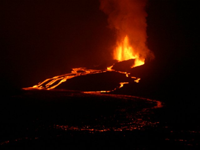
haha Io gives me these toughts
Obi Wan looks at the defeated Anakin in huge, enromous
dissapointment –
Obi Wan screams out
You were the Chosen One!,
It was said that you would destroy the Sith, not joining them!!…bring balance to the Force, not leave it in darkness!!
Anakin that fallen to the dark
side screams out to Obi Wan I HATE YOU!!! twisting in pain ..
Obi Wan slowly walking away from the raging lava rivers edge while Jupiter looms in the sky, he takes away Anakins dropped lightsaber causing a rage in the already angry Sith apprentice.The intense heat of the lava will soon seal skywalkers fate, as he catch fire, first the clothes then the skin, soon you dont see him anymore just a pillar of fire that have something in it. Obi Wan walks away in horror.
An hour later using the power of the dark side, skywalker manage to stay alive, and manage the flames inferno around him stop, he pulls his way from the raging lava rivers edge, severely charred but still alive. Darth Sidious / Palpatine his new master feels Anakin is in trouble on Io and flys there togther with a stormtrooper patrol.
( Stromtroopers searching Io s surface togther with Palaptine ) .. looking across the raging moon landscape they see a burned shape. Stormtrooper Clone ..Your Majesty this way!!! Palpatine sees the charred shape thats his Sith apprentice .. Palpatine should there he is! .. and he is still alive.. Palpys grey face shouts out – send a medical capulse instantly! .. the clones – yes sirr!
Its Impossible for me to not think of the Revenge Of The Sith when I think of Io
So Io Will always be the Mustafar for me
Sentinel 2 picture https://i.imgur.com/BiObzE8.jpeg
It looks like the lava reached the wall in a couple of places and was stopped.
This is cutting it a bit fine
Excavators working on hot water pipes on the afternoon of February 8, 2024
RÚV – Ragnar Visage
The 3D model of the eruption is up already.
https://sketchfab.com/3d-models/sundhnuksgigar-eruption-08022024-time-1300-d3c8a7940b38489cbfc47cd14ff662c1
the part of the lava stream nobody was watching, from the southern end of the fissure, flowing off to the east and nowhere near Blue Lagoon and Svartsengi power plant…what kind of gigantic hole did it disappear into? :-O
From the Langihryggur camera, at 00:17 am Friday I see 3 or 4 fissure vents active, the one in the middle toward the center seems to be new to me? Did this just recently occur? https://livefromiceland.is/webcams/langihryggur
What a beautiful eruption this is.
https://www.youtube.com/watch?v=YAQzsB9ev9Q
It is indeed!
Is that now a cinder-cone? Daylight will reveal.
4.45 am, this is pulsating mesmerising, would this be called Strombolian, or is it too small?
It is spattering, which I tend to think of as small scale strombolian activity. The line between them is a bit arbitrary really, I guess if there has to be a line it is where the lava is thrown high enough it doesnt stick together when it lands but that isnt a hard line.
I think it’s the added contrast with the snowy-grey surrounds. I might ask my dad to paint it.
Still going…
Would admin please remove this post, as obviously I fell into the same pothole. Thank you.
As requested. Geolurking.
The GPS trend is showing the drop now, from the lava flowing into the dike. Overall, the drop looks similar to the drop in Decenber, but greater than last month.
Apologies if already asked and answered, but –
GPS site SKSH seems to have gone offline as of 31 Jan 24. Does anyone here know why?
It seems to have restarted in the last day or so.
Thanks, Richard. SKSH is an old favorite hangout. I’m glad to see it’s still doing its part.
It was the one I was checking, until I found HS02. I tend to check that one now for a quick look and SKSH, HS02, THOB and Eldvorp as well when looking in more detail.
Not sure if this has already been posted, a good drone vid –
When lava flows over roads, is it possible to remove the solidified lava from the road and how much effort will it take to do this?
Someone asked Shawn Willsey a similar question.
In Hawaii, it seems the lava was “roughly graded”, not totally removed.
https://highways.dot.gov/public-roads/summer-2020/facing-volcanic-challenges
I can find no information about Iceland’s repairs. Possibly they may prefer to avoid gradients on asphalt roads, because of ice, so remove the lava. After the inconvenient cooling-off period. There are a lot of exciting-looking unpaved roads!
https://www.dangerousroads.org/europe/iceland/2735-kjalvegur.html
Ooops, yes, has already been posted.
The Road Ditch caused significant steam activity. But was an interesting meeting of fast liquid lava with snow.
Looks like the eruption is taking a break or is over until next month.
Still a lot of steamboat only two very small hot spots.
Source: https://www.livefromiceland.is/webcams/fagradalsfjall
At https://english.hi.is/news/new_understanding_of_ultra_rapid_formation_of_magma_filled_cracks_in_the_earth “New understanding of ultra-rapid formation of magma filled cracks in the Earth”.
This refers to the same Science article mentioned earlier in the comments. A magma flow of 7400m3/second is truly remarkable. Here’s another article referencing the same paper: https://comet.nerc.ac.uk/observations-and-models-of-icelandic-eruption-lead-to-new-understanding-of-volcanic-systems/
Compare that to 2800 cubic metres/s of water flowing over Niagara Falls.
I would be curious to see whether by next summer the Fagradallsjall volcanic system will continue with its normal cycle of eruptions of the last 3 years or whether the Svartsengi volcanic system (the entire fracture area) has altered something deep down like the supply of magma.
It’s possible that we get 15 eruptions on Iceland this year: 13 of Svartsengi, 1 Fagradalsfjall and 1 Grimsvötn. That’s very unlike the average eruption number of one per five years.
You’ll just see them building taller and taller fortifications around the blue lagoon until it starts looking like medieval castle, but just with a moat made of lava!
Maybe they should build an alternative Blue Lagoon somewhere on WVZ’s volcanic systems. F.e. close to Great Geysir. https://www.south.is/en/place/geysir-geothermal-area
Secret Lagoon is already in that general area, not quite Geysir, but about 30 minutes or so away.
Geysir is about 2 hours drive from the Blue Lagoon. Highest legal speed in Iceland is 90 km/hr and that is only on paved rural roads (so basically just the ring road) so it takes longer to drive a long way than it might in most other places.
The bonus to that is that you can drive your electric car quite a lot further than its rated range, about 50% more than rated for the model 3 RWD which is usually the rental of choice. One charge will nearly get you 650 km. And then you can charge it with clean geothermal and do a road trip in a volcano powered car with electricity that is basically free 🙂
That might be tempting fate to build the Blue Lagoon on the WVZ 😉
I think the Grindavik fires should be seen as a single episodic eruption. And I would guess that some of the Reykjanes fires of 1000 years ago happened in the same way.
Would you compare it with the early episodic Pu’u O’o eruption 1983? There also were times of pause and waves of eruptions. GVP counts 12 episodes 1983. Maybe a number, that Grindavik can reach 2024.
Good comparison. Both seem dominated by rifting and continuous magma supply. The rifting is the episodic part. Once the rifting has rifted as far as it will go, the eruption may change character. This is speculation! And pu’u had access to a far larger eruptible source
That was my comparison too, there seems to be a mature mechanism by which the sill inflates and reaches a critical point. At Kilauea in the 1980s it seems the magma flow was constant up to Pu’u O’o but the complex of intrusions was right under Pu’u O’o so an open hole could degas the magma in the conduit and axt as a plug. The pressure eventually got too high and the degassed cap was pushed out as a fountainless flood of lava, sometimes out of flank vents nearby, before the fountain went off. That being said Pu’u O’o was more of a fissure eruption for the first 6 months before it comitted to the one vent, and there were many eruptions at that location in the 60s and nearby in 1977, so the area was primed.
At Svartsengi the active rift is on the edge of the sills, and the blockage seems to be an actual physical obstruction of the crust sinking down and closing it off. But this eruption was both more intense and also more voluminous while also being a shorter fissure, so if this sort of frequent rifting occurs maybe only a short section of the fissure line will erupt in future, with huge output. This didnt happen at Eldvorp but that might be because the eruptions at Arnarseturshraun occurred from a different dike. And it does seem to be what happened at Sundhnjukagigar in its last eruption, which after looking at it closely does clearly appear to be at least two visible large flows and several parallel fissures, who knows how many buried flows there are.
If a high supply to the system is sustained though I dont see why the blockage might not eventually give way permanently and one of the fissure eruptions doesnt just stop but ends up going for weeks or even months, like Arnarseturshraun, or indeed like the eruption in 2021. The line of quakes under Fagradalsfjall is also interesting as it may indicate where magmatic activity will occur in the future. The Sundhnjukur fissures were where quakes happened during the Fagradalsfjall eruptions a few years back, and now became magmatic themselves. Its not a direct cause so much but an indicator.
It’s possible that Fagradalsfjall’s whole series of Fires is going to last for 100 years, while Svartsengi likely finishes around 2053. Fagradalsfjall did nothing since 8,000 years ago. It has time to “revenge” this long dormancy.
The Svartsengi Fires can over time change their behaviour. We saw the Fires of Krafla changing their behaviour 1975-1984. I can’t imagine that Svartsengi can do the current dense frequency of eruptions for 30 years. There must be a change once towards more rare, but bigger eruptions. I’d assume that the location of eruptions migrates towards the Northeast over time, maybe even with interaction with Fagradalsfjall’s lava flows.
Saw on IcelandGeology a very interesting point that the phreatomagmatic activity yesterday was likely caused by the eruption in part of the fissure ending so suddenly with a pressure drop that the fissure walls collapsed, allowing ground water to rush in and interact with the lava.
Also got a question regarding the erupted volume. The Met Office estimates that more than 15 million cubic metres of magma was erupted in the first 7 hours of the eruption alone, and also that their measurements indicate that 10 million cubic metres moved from the storage area under Svartsengi. Since 1pm there obviously was quite a lot more material that erupted as well. So where has all this extra magma been hiding, or did it get directly fed from a deeper source? Perhaps no one knows yet, but I’m always happy to hear speculation. 🙂
Maybe there has happened what the model of HVO for Kilauea’s explosive eruptions includes: A drop of magma lets groundwater run in and make phreatomagmatic explosions.
That was the assumed process up until 2018, but the summit collapsed without any phreatic eruptions. I’m sure researchers are revisiting 1924.
Indeed this model failed 2018, but it can apply to some recent hydrothermal/phreatomagmatic explosions of Svartsengi.
I don’t think the last eruption erupted all the magma it could have done. As far as I know the intrusion was similar, but the eruptive rate and duration was less than the first eruption.
Reading the paper linked above, the volume of lava in the dyke has been estimated at 130-139 million cubic metres. At 10% eruptive volume, that is close to the 15 million cubic metres that erupted over the past day.
There have been a series of inflation events over the past few years, with an estimated 13-15 million cubic metres in the sill complex up until May 2022, when reading through the paper. Also reading the main article and not just the summary, they are/i> saying there was an intrusion rate into the dyke of 7400 cubic metres/s on 10th November for a short period, between 1800 and 1900.
I don’t have the knowledge to follow everything they are saying, but there is quite a bit lava floating about.
The typical Svartsengi eruptions are short and small in sum, but very unpredictable and risky during their onset. The high number of eruptions makes it difficult to predict the location and behaviour of the single eruption. The direction of lava flows is uncertain (beforehand) and the possibility for phreatomagmatic events is difficult to estimate.
The duration of the Svartsengi eruptions reminds to Krafla fires, but the recurrence time is much shorter. Krafla also did several intrusions without eruptions (like Kilauea currently), it is a big volcano with space for intrusions, while Svartsengi has not volcanic mountain to bear and hide intrusions. Intrusions that remain intrusions in Kilauea, Krafla or Vatnajökull, become eruptions at Svartsengi.
If you have time, HVERI (Hawaiian Volcano Education and Resilience Insitute) has published a 90 minute lesson by a Geologist about the recent SWRZ intrusion: https://www.youtube.com/watch?v=Cljje_AeaOM
… and HVO has added an Volcano Watch article about the SWRZ intrusion: https://www.usgs.gov/observatories/hvo/news/volcano-watch-another-intrusion-southwest-kilaueas-summit
How close is the current intrusion to the 1919 intrusion (leading to Mauna Iki eruption)? The current intrusion has created cracks in the Kau Desert that remind to the 1919 cracks.
 ?itok=tWlO2FHT
1919 “fissures in the sand”:
https://www.nps.gov/media/photo/gallery-item.htm?pg=6534899&id=a5ea322f-5814-4dc5-8d5e-f4b2060846b9&gid=22BABE50-D715-4720-90BE-B2D980E1E407
The cracks in the Kau Desert remind to Grindavik’s cracks along the graben above the sill/dike.
Its not similar to the 1919 intrusion, that was basically the summit lava lake breaking out and then finding shallow subsurface cracks to flow into passively. It took days to happen while these intrusions basically all happened in a few hours. Closest similar recorded event is in 1981 and 1984 but both of those made a single large dike out of the south caldera area while this one was a smaller dike, and a second dike formed out of the lower end of the connector. The lower end is one to watch as gravity will prefer it to the summit so long as the system is open.
One other thing is that large rifts will open cracks in adjacent areas too. The many intrusions on Reykjanes in the past 4 years have opened up ground cracks all over the peninsula as far as Reykjavik even though no intrusion has yet gone anywhere near there. And Kilaueas SWRZ moves a lot more than Reykjanes does, there are lots more cracks so new at tbe surface might not mean created last week. Mauna Iki trail also goes across all of the SWRZ, from the highway next to Mauna Loa over to the lookout at Hilina Pali I believe.
1974 not 1984
I guess that is what the Grindavik cracks would look like without a town on top.
In Kau Desert as well as in Grindavik is the deadly danger of traps above such cracks. The Desert has a lot of old tephra sand, that can easily built deceptive deadly sand bridges over the cracks. If I’m right, the Mauna Iki trail crosses the crack.
That could be nasty. Holes in the ground are a scarey concept.
That is quite a flow rate.
“Volume estimates of the erupted lava from the start of the eruption at 6:02 until 13:00 yesterday (8th of February) is about 15 million m3, which corresponds to an average extrusion rate of 600 m3/s during the first seven hours.”
Full statement published today 13.00 UTC here: https://en.vedur.is/about-imo/news/a-seismic-swarm-started-north-of-grindavik-last-night
The extrusion rate is around 50 times larger than Fagradalsfjall. The eruption in July 2023 had 13m³/s with later decrease. The total volume was 15,5 million m³, so nearly the same size as Svartsengi III. Fagradalsfjall III did during 25 days the same volume like Svartsengi III in one day.
The high eruption rate makes it very difficult, to build good dams against the lava. Svartsengi is a disaster volcano, while Fagradalsfjall is a tourist volcano.
Do they assume that the whole event is volcanic? Have they adjusted for triggered earthquakes?
In an unexpected cross-over travel blogger “Walk with me Tim” booked himself into The Blue Lagoon – you can guess what happened next!
Where did that stratovolcano in the background come from?
There’s been quite a lot of uplift in the area recently 😉
No idea. He has some god footage of the eruption in the video towards the end.
Another one of Tim’s videos with geology content from a few months ago.
https://www.go-below.co.uk/deep-sleep.asp
Big quake in Hawaii. Preliminary 6.3.
Revised to a 5.7 north of Pahala.
The intrusion has maybe caused a tectonic earthquake
Wow 5.7 down in the mantle, must have been felt all over the state. Were it anywhere else it would be a flexure quale from the crust ctacking under the weight of the island but there might be more to it in this location.
This bit of the map is just outside the quake map for Kilauea and Mauna Loas map is only st the summit, while the live map is much more selective of what quakes get shown. But it does look like the pahala quakes were less active than in past months for a while, this might be pent up strain. The deep quakes could be very active for the next days.
Not sure of your wording…but HVO says the quake was from crustal flexure.
From HVO:
“This earthquake is likely associated with lithospheric flexure caused by the weight of the Hawaiian Islands on the oceanic lithosphere”.
We’ve gone throuigh this before. There is going to be a signficant eruption on Hawaii big island very soon. The quake is informing us that an isostatic balance is trying to be established with the current stress, but this will open the doors for new ways for magma to reach the surface.
It is a flexure quake but at this location there is a likely case for it to be more complicated than otherwise. There is quite the swarm around it which seems excessive compared to what usually happens around flexure quakes of this size, and typically such quakes are deeper and further from the most active areas, like up at Kiholo Bay or around Maui.
This is an earthquake of the Pahala Swarm that has been seeing an unprecedented frequency of earthquakes since the deep tremor surge of 2019, so I would agree with Chad. The earthquake is probably related to the ongoing magmatic crisis under Pahala.
The HVERI video, I mentioned above, talks about blocks that slip on the southeastern flank of Kilauea and cause earthquakes. These blocks move down on Kilauea and up in the seabed SE of Big Island. I imagine that the intrusion of a lot of volume (it was more than the 9/2023 eruption) increased likely the tectonic pressure in this area and let the block move a bit more than usually.
There is also a very large permanent offset in the tiltmeters at Kilauea after this quake, 10 microradians at UWEV and the blue line of SDH (points at Halemaumau) and 50 microradians on the green line of SDH (points at SWRZ connector). The tiltmeter east of the caldera also show 10 microradian drop both on the ERZ and the coast, and JKA station was shoved by 100 microradians before settling back to near its original position.
The one at SDH is striking, the station recorded a near instantaneous drop almost as large as last weeks intrusion, and way larger than the summit only a few km away. Seems a very extreme reaction to a mag 5 quake over 50 km away.
For me this post is almost information free, I am afraid.
I’m trying to be nice but its quite hard to be a teeny bit critical and still be really really nice.
Sorry.
It just says the earth has moved, which I knew from the earthquake.
If this is all the information one gets from tiltmeters (and I know it isn’t) then they are pretty worthless.
We have the usual angle – distance confusion as well.
It would be really helpful if those in the know would interpret the tiltmeter data rather than just state it.
It means the whole south flank of Kilauea moved a tiny bit during that quake, and the southwest side moved a lot more, and nearly as much as it did during the intrusion. Quakes will often jolt the tiltmeter but it doesnt usually have an offset let alone such a big one from what is really not a particularly big quake that isnt very close to the instrument
Ok, but you know where the tiltmeters are, I expect you know the location of the slab that moved (similar delta-R on several sumultaeously) so you should be able to convert that to a distance (to first order approx) both how big the slab is and how much it tilted.
I have no idea of the size of the south west flank (I think its an agreed area bounded by faults) to the nearest (say) 20% parallel and perpendicular to the tilt.
If it were (say) a slab about 10km ll’l and 5km perp then the delta-edge movement at 10uR would be circa 100mm. So quite a lot because the slab is quite big.
The thing is few people grok 1uR but many a 10km slab rotating 50mm each end about the centre.
The tilt just records the ground adjacent to it rising or falling, its not that complicated really, theres no rotation element in it that is detectable by the tiltmeters themselves. You need the GPS and other instruments as well as multiple tiltmeters to get usable data on location, otherwise it just records ground movement occuring somewhere on the instrument axis.
Im not sure if you are just trying to find reasons to complain about it to be honest.
It’s true that a jolt in a tiltmeter seems a bit vague, not that there’s pressure on being informative each time we write though. Sometimes a jolt in tilt is just fun. When getting more serious it looks like most tiltmeters didn’t shift during the earthquake, only UWE and SDH. The direction of tilting in those two seems to be due to the angle of the ground with the vertical decreasing when looking northwest from both stations. Which could be the ground rising to the northwest or falling to the southeast. I’m not really sure why is this when the earthquake happened a good distance to the southwest from the two. All I can think is that Halema’uma’u and the South Caldera areas experienced some sudden deflation from the shaking. Also, SMC has no data (as usual). Didn’t a Mauna Ulu tiltmeter just vanish? can’t seem to find it. And UWE for some reason shows only one component as usual, I guess Halema’uma’u is the only thing UWE cares about and refuses to hand out data in other directions, jk. Well, as long as unrest remains in Halema’uma’u and the SWRZ connector, then UWE and SDH is all that’s needed.
But HVO`s GPS are no better. The GPS stations have still not been updated since before the dike intrusion! It always takes a few days, but it’s been over a week now since the dike intruded.
Hi Chad,
If two tiltmeters on a (known) same slab both tilt by (say) 10uR and the slab is 10km in the direction of tilt then that’s delta 100mm of movement.
If, on the other hand surrounding tiltmeters (on the same slab) show little or random change then its likely a local even of perhaps only a few hundred meters and movements of only a few mm. I think this is two different things so its relevent.
PS I am somewhat baffled by your statemnt that tiltmeters do not record a rotation, though. Could you elucidate?
I was just noting that this seemingly small quake very deep under the island managed to create a permanent offset in most of the tiltmeters on Kilauea, and not a small one in the case of SDH. Its probably not important in most of the stations, but that 40 microradian drop at SDH is not insignificant.
some longer blog about this EQ.
https://earthquakeinsights.substack.com/p/m57-earthquake-shakes-hawaii
Been a lot of very shallow earthquakes off the southwest flank of Kilauea, many under 1 km deep despite being offshore, I wonder if maybe these are submarine landslides from the flank slipping during and after the recent intrusion, and again after the new big quake.
An unanswerable question I have is: What did the seismic and deformation regimes look like before Wood Valley 1868? I don’t think there’s any way of determining that we are/aren’t leading up to something similar.
Well, we can speculate. I have some speculations which I’m still exploring. The 1868 eruption was picritic with a lot of olivine crystals, and in general the eruptions during that time were highly magnesian (I’ve checked in GEOROC data). Overall, the primitiveness of Mauna Loa’s magma raised through the 1850s, and peaked around 1868 or so. So one thing I think is possible is that a batch of dense, primitive, magnesian magma entered the volcano and slowly wedged open the deep rift of the volcano eventually triggering a very large dike intrusion to low elevations that was the tipping point. It’s rough speculation but my intuition is that it has something to do with the uprise of primitive magnesian magmas. A similar thing may have happened to Kilauea in the 1960s and 1970s, when the magma from Mauna Ulu stayed above Puu oo’s most primitive compositions and there were some other spectacularly primitive eruptions in 1959, 1960, 1968, or 1974. What came next? The M 7.5 earthquake of 1975
The magnesian magma likely indicates the onset of an active volcanic period. It is caused by a new wave of magma from deeper, not evolved ressources. After 1868 Mauna Loa had a dominant eruptive period. The 1960s and 1970s were likely a similar onset of an over-average active period of Kilauea with a wave of new magma in the system.
New fresh magma often destabizes a volcano. We saw this at Stromboli with some sudden big explosions. Also Etna’s explosive eruptions were likely caused by a fast rise of relative primitive magma. On Hawaii this instability causes earthquakes, because the new hot fresh magma often takes uncommon roots and has uncommon behaviour.
“Also Etna’s explosive eruptions were likely caused by a fast rise of relative primitive magma.”
I can confirm this. I recently saw some data about recent Etna eruptions where the magnesium content of the lavas for the 2021 paroxysms has some of the highest values known for the volcano, comparable to the so-called eccentric eruptions. I think I saw it in the supplementary data to this article:
https://www.sciencedirect.com/science/article/pii/S0012825223002520
33 fountains over 1 km tall, 10 of those were over 2 km tall.
And the eruption on the 2 February 2022 had a 5 km tall fountain.
I am not aware of anything even slightly comparable to this in Etnas recent history, the only thing that sounds similar is the plinian eruption in 122 BCE, which was much more voluminous. The massive fountains in 2015-16 and in the late 90s from the Voragine were previously the record of tallest fountains, alongside the 1986 eruptions on Izu Oshima, which was 1600 meters. But neither of those even come close, and its not like it was a rare occurence in 2021 either it was almost half the time.
Also about 51 million m3 of tephra, and probably a similar or greater volume of lava too, the volume likely being over 100 million total.
There was about 5.3 days of actual fountaining time too, the eruptions on average erupted tephra at 110 m3/s, although as with Bove the lava volume is unknown and probably at least as much again or even more in most cases.
I’m also thinking about the major explosive-effusive eruptions 2001-2002 with a lot of tephra. If I’m right, this were the last destructive eruptions of Etna. After this Etna mostly did short Paroxysmal eruptions. 2001-2002 also contained some water magma, so it could have been a mixture between a “hydro-magma” and a magnesium magma eruption.
I think that really will be impossible to know until it repeats. I dont know if there is a way to tell how frequently earthquakes like that happen but if a low altitude eruption is a typical cause then it may have been millennia since the last quake as big as 1868. The last eruption near Kahuku pali is at Pu’u O Lokuana that is between 2000 and 3000 years old while also much smaller than the 1868 eruption, and before that was Akihi at about 4150 years ago. The Akihi eruption seems to have been a huge lava flood eruption likely a caldera collapse.
Really the fact 3 historical eruptions have rifted into this area beyond the ‘bend’ is quite extraordinary. It seems for many millennia the only bit of the SWRZ that was active went to just above Ocean View and basically a straight line from the summit. Even massive multiple km3 lava floods like Hapaimanu and the violent rifting of 1950 didnt break this trend, even though both of these were much more voluminous than the 1868 lava. To be honest the fact the 1868 eruption wasnt something far larger than it actually was is the bit that surprises me, it erupted 0.25 km3 of lava in 4 days, nearly as high as the peak intensity of Laki and not much slower than in 1950 which was a 10x longer fissure. And the difference in elevation from the summit which had erupted days earlier and the Kahuku fissure is about 4 km, I cant think of anywhere else with such a large elevation contrast, it is about 6x the difference that any Icelandic volcano can do presently. I guess maybe the massive flank movement put the dike under compression so it shut off suddenly.
What I wonder is, what is the current status of Mauna Loa. Historically its been very active. I know its had lava lakes not too long ago. Is it possible for it to go into an active phase?
Seems like there’s little supply right now, deformation is nearly flat in some of the graphs:
https://www.usgs.gov/volcanoes/mauna-loa/science/monitoring-data-mauna-loa#main-content
What I was kind of inferring is that the activity Mauna Loa had between 1840 and 1950 was exceptional even for the past few millennia, not by volume but by frequency of activity and the locations vents were able to erupt. Eventually it will do this again but it might be a while. The summit overflows might be a bit different, I think HVO has interpreted summit overflows with high supply but also never looked at the rift zones. So its only half the story, the summit lake overflows are probably just when the rift zones are not active.
One other thing too, the 2022 eruption of Mauna Loa was voluminous and fluid but both the lava temperature and MgO content, which are related to supply rate, were relatively the lowest values of any historical Mauna Loa eruption, at 6.8% MgO. Compared to Kilauea which in 2018 erupted up to 9.5% MgO and had a temperature of over 1200 C in the lava lake before that. I havent seen composition data for post-2018 lava anywhere but the stuff in September looked extraordinarily fluid and gas rich so is probably of a similar composition to the hotter 2018 stuff.
Not to mention, the supply rate of magma to Kilauea in 2023 seems to have gone up from the Pu’u O’o days.
Sooner or later Mauna Loa has to do a real Summit eruption again. The last one was 1949. They can last for 100 days, what is a long time for Mauna Loa. Eruptions like this would be good tourist eruptions. But Mauna Loa takes time to refill.
A question is: Are Mauna Loa and Kilauea really negative correlated or do they do their eruption cycles independently? Kilauea has – if I see the history correctly – done a cycle from 1790-2018. Mauna Loa might be in a larger cycle from 1800 to 2100 with Hualalai eruptions during a quiet period of Mauna Loa.
“To be honest the fact the 1868 eruption wasnt something far larger than it actually was is the bit that surprises me”.
I think Mauna Loa still had not recovered from the ~1670 Hapaimamu eruption, it had not grown back a large shallow magma storage by 1868. The giant dike all the way down to Kahuku must have also taken up a lot of the volume, the summit was probably collapsing by the time the eruption started.
I am not familiar from with the Hapaimamu eruption. What happened then?
https://www.sciencedirect.com/science/article/pii/S0377027322002219
Some large eruption on Mauna Loa.
Jbean it was an eruption about twice the volume of Holuhraun that happened from a large scoria cone above Ocean View estates in about 1700. Was probably what created Mokuaweoweo
I can’t reply to chad for some reason, So I will post this here. Thats quite a low elevation. Did Mauna loa have a lake it drained from? or did it just drain the summit chamber?
Maybe there was a lake or it might have had just a flat summit and filled caldera like today. Its not unlikely the next active period of Mauna Loa will end with a similar eruption but there is no evidence it is building towards that presently.
Hapaimanu would have been a lot like the eruption in Leilani Estates in 2018, or like Holuhraun. It was about twice the volume of those two and being so low down the intensity was probably a lot higher at the peak, probably closer to Laki or even at equivalent intensity if the 1868 eruption is a fair comparison. At that rate the eruption would have been over in about a month, compated to 2 months and 6 months for fissure 8 and Holuhraun respectively.
Next round: March 5th, south of Hagafell. 😉
Hopefully not as if it flows as fast as this last eruption it will likely cross the road from the east into Grindavik thus severing access from the east. They are running out of options for that town I think. One thing is for sure, they will soon build at least a dirt road into the Blue Lagoon as soon as possible. They still have one entry accessible.
Agreed on next location, not sure about timing, but the SENG 8 hr GPS is already showing inflation again, as a few others too, so that didn’t take long to get over the current episode and restart. See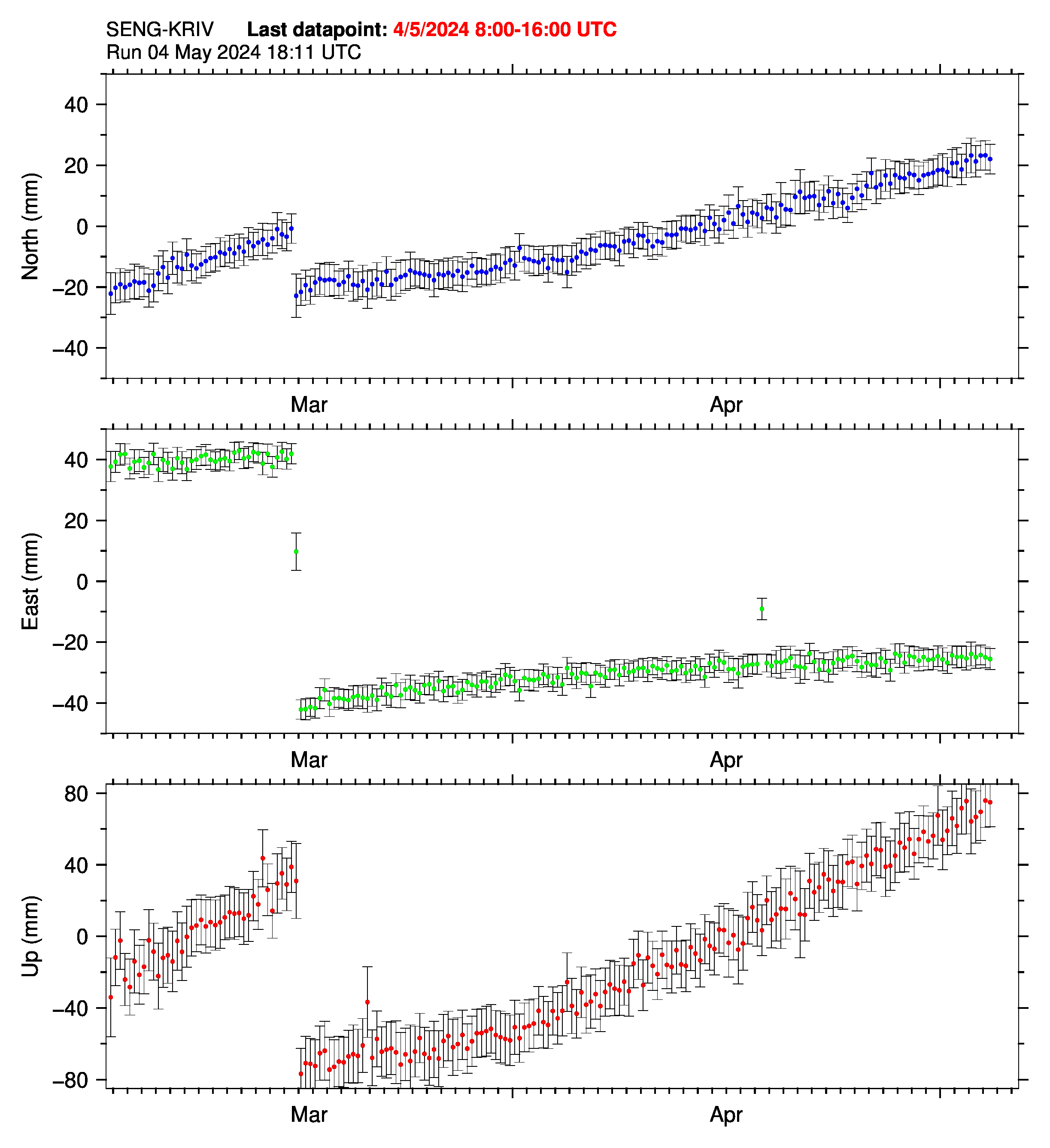
That looks like the rate of uplift is increasing since the eruption.
Now that the Icelandic excitement is over, just take a minute to ponder what the thinking and discussions would have been like if plate tectonics hadn’t been discovered. It’s not that log ago, and it wasn’t easy or immediately accepted..
Nice description and interviews here:
https://youtu.be/rY9IL1F9aj8?si=OFMUWZNeq9wf3vIe
Plate tectonics or the concept that the continents moved relative to each other has been known for a very long time indeed (>century+) because geology and fossils matched across the atlantic, and later all the other connections. This more in europe, perhaps, than the USA (probably due to religion). The trouble was nobody could figure out a methodology until the MIR was discovered mid 20C (probably ~1960’s). Then everything fell into place when the “ring of fire” could be explained.
At school in the 1950’s old (even then) encyclopaedias and geology books had it as ‘common knowledge’.
I’m glad that the Neptunic approach failed. A world ruled by water would be more boring than a magma planet.
In one aspect the Neptunic approach was correct: Magma contains water, that makes a geological water cycle. Subduction takes water down into the mantle, and contained in magma it rises back to the surface.
Copernicus website published a wonderful picture of the new lava field in their Image of the day gallery, on 09/02/2024. The picture is on display today in the Copernicus.eu home page and the image file can be downloaded from the Image of the Day web page.
Image of the day page link
https://www.copernicus.eu/en/media/image-day
Cinzia
Cinzia
Now that this 3rd eruption on the same dyke has finished, I started to ponder that the first eruption set the standard and lasted approximately 2 days with approximately 5 hours of warning. The second eruption had around 90 minutes warning and lasted less than 2 days. The third eruption gave roughly 30 minutes warning without a lot of massive quakes, so for most people no real warning at all and then it lasted just about 24 hours or possible less.
This leads me to think they becoming more dangerous due to the shorter warning time and that they are also flowing much faster than the first eruption in that area. I realise that 3 does not prove a trend but it is a little worrying all the same.
Now I am wondering how long this cycle of ‘fill and empty’ can continue. Obviously it will be until the magma supply finishes but do previous episodes of ‘Fires’ in Iceland give any clue as to how long until thesupply is exhausted. So many questions and so few answers. It appears to me that the poor scientists are almost flying blind in regard to being able to give any real predictions on the possible outcome.
The drop in the GPS was not all that steep, so I think this will erupt again in 3-4 weeks with something similar to December in size but equal to Thursday in flow rate. Until there’s a lull and we have a larger eruption, or the eruptions become more frequent.
I suppose it is dependent more so on when the tension in the crust is released and all the gap filled with fresh magma, rather than the magma chamber emptying or not refilling quick enough. Once there isn’t space to erupt, we may see it erupt at Eldvorp instead.
Lava coming out faster because overall pressure in the system still increasing?
Have they (or you or anyone) counted the hours of this eruption? If eruptions are so short, hours count more than days. F.e. Mauna Loa 1975 six hours. Krafla 1975 also six hours (only one hour of effusive activity).
How do they determine the stopping hour of an slowly dying eruption? Is it the end of tremor? Do steam/gas Fumaroles still count as “eruption” or already as “after eruption”?
Yesterday 15:30 UTC IMO wrote the “eruption is ending”. If this was the time point of the eruption’s death, then the eruption lasted for 33,5 hours (one day and 9,5 hours).
I think the IMO go by whether any magma isvisible at all in any one of the chanbers. I only know that the eruption started at 6:22 but by the following day at 6:)2 I could see no lava erupting from any vent. Just smoke. If it is erupting no lava then in my view the eruption part is over. Magma sitting in a cone for a certain amount of time is now what I personally call erupting. That is why I suggest it stopped erupting within 24 hours. Lava under the crust is still lava but not erupting lava.
Obviously the IMO have to be more cautious than myself before declaring the eruption over.
Sorry that should be started at 6:02. Laptop keyboard getting old.
I’m not sure its primarily magma pushing upwards that is the cause although the hydrostatic force on a column of hot rock that is a teensy bit lighter than the surrounding rock is actually quite high due to the high density or rock (then there are gasses etc). Surely what we are seeing is the opening of the MAR after 1000 years of unrequited separation (is that about 10m?) and something has to fill the gap. The problem here is the MAR is about 45 deg to the direction of separation and the area is filled with old dykes, indeed it IS just a bunch of old dykes.
Alice, I share the same concerns, especially the concern about the warning time becoming less. One big question I have is this “Can we tell how long the upwelling from the mantle into the sill chamber will last?” As long as that is going on, we’ll see these Sundhanukar fires continue. Also it would be nice if the borehole pressure readings were made public, so we could watch the compression/relaxing of the crust in realtime, but I don’t think those readings will ever become public.
Borehole reading close to Hekla used to be published by the IMO. Sadly so many things have disappeared from their website. They must have good reason, but it is nonetheless frustrating. Not that I know how much prior warning theborehole readings actually give.
Has anyone observed the distribution of earthquakes along the Reykjanes peninsula during the six hours before the eruption began? It would be interesting to see if there is a pattern anywhere outside the Grindavik area.
I have noticed that with the last 3 eruptions there has been increased quake activity along the line of Eldey towards the peninsula. I have no knowledge if that is in any way significant but it is something I shall look for before the next eruption in 3+ weeks.
Alice’s comment is appropriate. We have seen strange or odd activity in the Eldey area before. I personally think there is a connection somehow, even though they are 10’s of km apart.
Will the Grindavik Fires continue to do randomly fissures or will it once concentrate on a longterm spatter cone? The Pu’u O’o cone formed with the fourth episode in June 1983. Before this, the first three episodes were more randomly distributed over the whole distance from Napau Crater to Kalalua Crater.
I would like to think that the lava emplaced by the Eldborp flows would be somewhat of a guide as to how this current episode will play out. See fig A from the new paper page https://www.science.org/doi/10.1126/science.adn2838
To me this would also indicate that Fragradsfall is not done yet either.
Thanks for posting that link Randall. It was mentioned in Shawn Willsey’s last youtube video and I meant to bookmark it to read but then forgot. Penalties of age. Even he found the article a little heavy though at a quick reading, so I am not sure how much my brain will assimitate but I keep trying despite reducing memory. Use it or lose it they say. 🙂
If that is the case, it would be a another few months before Fagradalsfjall erupts. Based on the dormancy periods of each eruption, which is a slightly little more than 320 days, it would be in mid-June. However, this is just speculation and it might deviate from this or not erupt at all. Besides, volcanoes are unpredictable after all.
However, if true, which is very unlikely, there is a small chance 2 volcanoes might erupt at the same time on the Reykjanes Peninsula…
The general absense of large cones like that in the Svartsengi area would suggest the eruptions dont form them, but Arnarseturshraun did evolve into a kind of perched lava lake and shield which is otherwise not seen in the area since the late Pleistocene so its not impossible either.
Certainly having the eruption focus into one spot would probably save Grindavik and make predicting the flow direction easier. But at the same time also make it more likely for flows to pile up over the walls too.
I can’t imagine that the eruptions of Svartsengi will continue for 30 years as during last 8 weeks. Sooner or later we will get some change, but what change?
Its not entirely clear if the individual rifting events really do last 30 years. The one at Krysuvik that made Ogmundahraun and Kapelluhraun seems maybe only lasted a few years around 1150 but it isnt really very clear.
I guess, based on the estimated size these rifting events are expected to get, around 0.3-1 km3 erupted, maybe double that which stays in the rift (just a placeholder, it might be much less based on what we just saw) and the supply of 5-10 m3/s to the sills, it might last around 5 years at the higher end. But so far Fagradalsfjall has had one eruption of about 0.15 km3 and 2 much smaller, so it could still be going much longer to erupt all of its magma, or it might do another more voluminous eruption like in 2021 again.
The thing is, this cycle also did start differently than last time. The last cycle started with eruptions at Brennisteinsfjoll, and it was not until almost 300 years later that the eruptions became frequent at the west end of the peninsula. Brennisteinsfjoll also erupted much more lava than the others, with two different eruptive series probably getting over the 1 km3 mark and 3 fissure swarms opening up. What we dont know is if Brennisteinsfjoll just has bigger eruptions than all of the others or if it went big because it erupted first. If it is the former then we have some time to prepare for it, though eruptions are likely there within 20 years apparently. But if the biggest eruptions happen where the first eruptions break out then we should expect a lot more lava at Fagradalsfjall and Sundhnjukagigar, and maybe much more than happened last time. That may be a silver lining as an eruption big enough to reach Reykjavik might not occur but most of the peninsula itself may need to be abandoned if Svartsengi and Grindavik are destroyed.
If 1 km3 of lava eventually erupts at Sundhnjukagigar though I think it would be fair to expect a change in behavior. Maybe a Pu’u O’o would form, perhaps still starting as a fissure every time but with a particular focus to one vent, where the dikes start.
Or to turn it around maybe instead of being big because it was first it was first because it was big…
Found this article on suggested flow rate into Svartsengi region was 7400 cubic meters per second…seems a very high number, is this article credible?
https://www.newscientist.com/article/2416365-giant-magma-flow-in-iceland-was-the-fastest-ever-recorded/
The article is from credible sources.
Update from Iceland Explorer (formerly Gutn Tog) on the failure of replacement hot water pipe.
sounds like metal fatigue due to excessively high thermal changes? or perhaps no expansion was accomodated ?? this is a significant engineering problem.
Since I tend to go with the cockup view of life they probably had to rush the install and there was a tiny flaw in one of the welds that wasn’t seen in the x-ray. Result fracture. They appear to have run the pipe up slowly and it worked, only to fail after a short time under full load. Without doing any sums I would expect the steam to be very effective at cooling the pipe from incomng heat from the overlying lava.
I’m impressed they saw the vulnerability of the old pipe and took immediate steps to alleviate it, which very sadly failed.
It seems these problems are a steeplearning curve for the Icelanders. The berm at Grindavik only failed at the area of the hastily closed entry for the road. Perhaps not enough time to do enough compaction of material? The berm at this last eruption wasnt challenged at all because the natuaral topography was diverting the lava but the height of that berm was impressive! It seems the opening to the berms will always likely be the weakest link.
I am sure though that they will soon find a solution to burying the hot water pipes, perhaps they need to dig deeper. At least this failure will be a lesson for the next time but then flows are very unpredictable because of not knowing where the next eruption area will be. The resourcefulness and the bravery of those workers has my full admiration.
The problem is that burying pipes is expensive, makes maintenance and repair difficult and perhaps more hazardous. They may have little choice however.
Also note that if grabens form across the pipes, they will almost certainly fracture.
We will need to hear from them why the pipe failed. I did see one excavator pulling mangled pipe from the trench, but it looked like soft metal from heat collapsed from the pressure, which is obvious in nearly all metals as the temperature rises, they become soft.
Indeed so, but not of cooled by a good flow of water/steam in the pipe.
Looking the Langihryggrur webcam on live from Iceland it looks like there couple be a couple of spots where the lava edge is still glowing. I guess this would be from the rut at the edges breaking and revealing the glow of the still hot lava.
But to so this wouldn’t it need to have fresh magma pushing out the cold crust? Therefore question for the experts here.
While the fountaining has stopped, could it be possible that there is still a low rate of magma rising, resulting in. Lava flowing slowly in some hidden lava tubes that are still extruding slowly at the edge of the flow?
Darn it the typing is bad. First line should say “could there be a couple of spots” and rut should be crust!