This is a repost of a summary by Hector, of the previous round of Reykjanes eruptions, a millennium ago. (The post is not as old as that, though. It was written during the first Fagradalsfjall eruption, at the very start of the new fire season.) The discussion includes two of the three Svartsengi eruptions of 1240 that ended the previous phase. It is probably coincidental that the current phase starts close to where the previous one ended. It seems eruptions sites are almost random across the peninsula. Fagradalsfjall had not erupted for 7000 years before 2021, and would have been nobody’s guess of where the reactivation would begin. There is a certain unpredictability about the Reykjanes eruptions. And as we see now, that extends even to ‘will it – won’t it’. Enjoy Hectors’ historic tour de force !
Now that Fagradallsfjall has finally erupted it is clear that a new eruptive period has initiated in the Reykjanes Peninsula, we can expect many more eruptions to come in the following few centuries, but what should we expect? and what about the eruption that has already started?
The last time the Reykjanes Peninsula was active was during a series of eruptions, roughly in the 950-1240 year period. Although there were people around, there was of course no one to take scientific notes, so the information is very sketchy. In an attempt to fill the lost history I have looked at a couple of lava flows in Google Earth and tried to interpretate their origin. And how do I do that?
Volcanic landforms reflect the kind of eruptions that created them, for example the height of a lava fountain is about the same as the diameter of the top of the cone that it creates. There are also various types of lava flows, pahoehoe sheets, aa sheets, tube-fed pahoehoe, toothpaste lavas, raised lava channels and ponds, all of this together, and with the relationship between the various features, the volume and complexity of the lava flow, it can give clues as to how the eruption happened.
Before getting into the individual eruptions I should mention the two general progressions that fissure eruptions generally follow.
Two types of fissure eruptions
We are used to used to seeing Piton de la Fournaise, Kilauea, Galapagos, or Bardarbunga erupt, their fissure eruptions follow one general pattern. First, the curtain of fire, when a long fissure bursts into a chain of lava fountains and for a short time the highest eruption rates are reached. Then the eruption focuses into one or a few vents and stays there, the effusion rate falls exponentially until it stops, or it enters a prolonged phase of slow activity at just a few cubic meters per second. From a curtain of fire to a single vent is the typical sequence of a fissure eruption.
However there is another important end member, this is a somewhat rare type and not many examples come into my mind, but there is a big one, the Timanfaya eruption of 1730-36 on Lanzarote, in the Canary Islands. This is a very dramatic case, but that’s why it’s a good end-member example.
Timanfaya started from one single vent initially, but then over the following 6 years, the focus of activity kept shifting from one vent to another, countless times. By the time it was over there were many vents lined up in a row, so that it looked like a fissure, but no one would have thought that when it started. There was no clear reduction in activity either, it just kept going, a terrible deluge of ashes and lava with no end in sight.
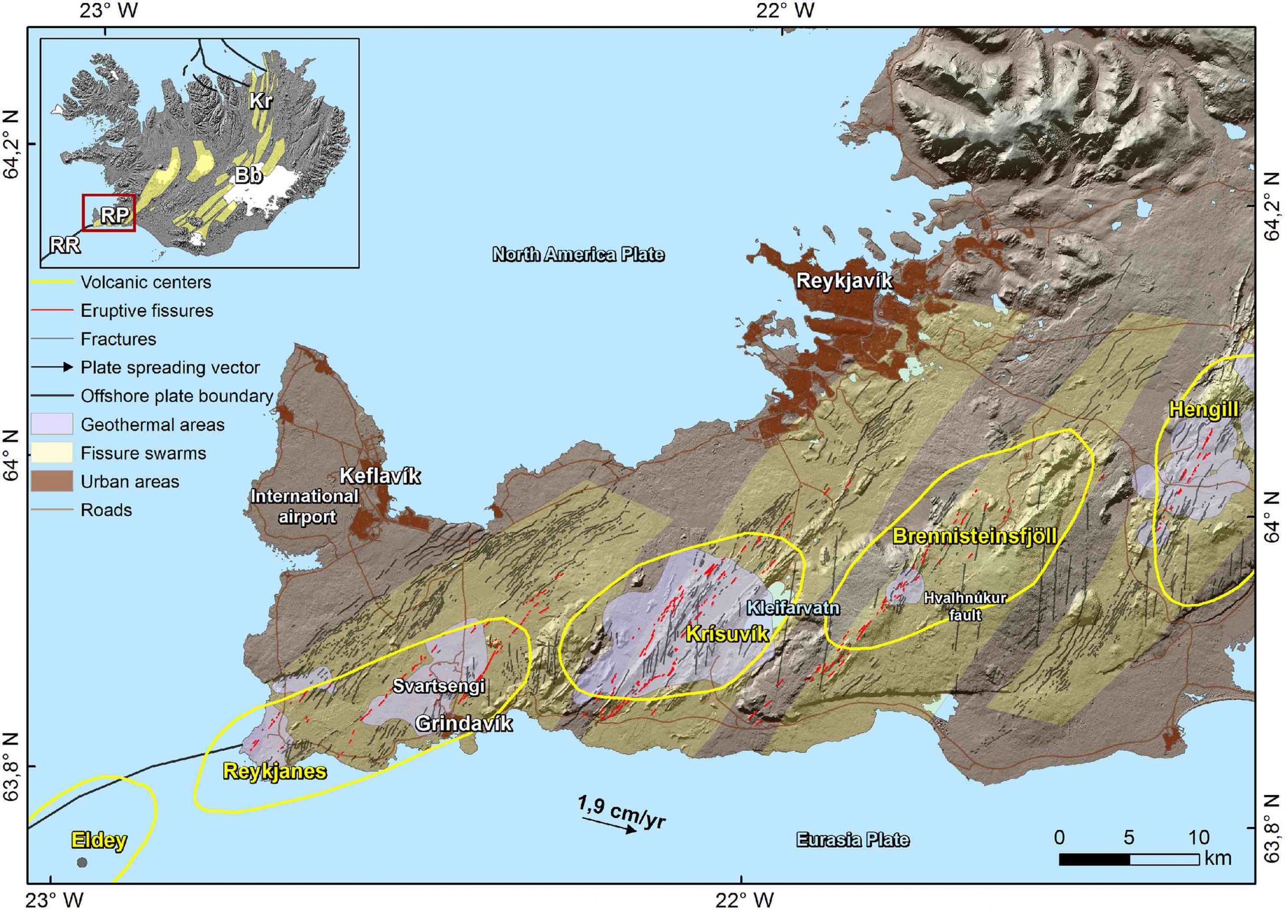
It’s not easy to tell apart the two types from looking at moss covered lava flows from ages ago, however, I do get the impression eruptions of Brennisteinsfjöll and Hengill may follow the Timanfaya type, whilst eruptions of Svartsengi follow the curtain of fire type, I’m not sure about the others.
And now, with that explained, we should start where the Reykjanes Fires started, with Brennisteinsfjöll.
Brennisteinsfjöll eruptions. ~950 AD.
There are four different historic lava flows in the Brennisteinsfjöll fissure swarm. All of them formed in slow eruptions, from fissures that were less than 500 meters long with one to a few active vents, and fountains that only reached up to 100 meters high at most. From what I’ve seen each of the flows must have been erupted in a period longer than a month.
Hellnahraun is an example of a very slow eruption. Lava moved inside lava tubes, it inflated from within and formed many small breakouts of glassy pahoehoe lavas. It was the sort of activity that was typical in the Pu’u’o’o eruption of Kilauea. Lava reached what is now the small coastal town of Hafnarfjörður, on the outer edge of Greater Reykjavik. Taking into account the volume of around 46 million cubic meters, and effusion rates that must have been in the range of lava tube eruptions, 1-10 m3/s, I estimate the eruption most likely lasted around a few months.

Example of pahoehoe lava breakouts. From Wikimedia.
Another nearby flow, Húsfellsbruni, was possibly the longest and most voluminous eruption of the Reykjanes Fires. It forms an extensive apron of lava flows that is extremely complex. It was hard to understand its origin story because at places there are as many as 4 or 5 flow sheets that seem to lie on top of each other. The eruption involved mostly channelized flows and aa sheet flows, but there were also lava tubes, ponds, inflation plateaus, and toothpaste lavas.
Toothpaste lavas, also called rubbly or spiny pahoehoe, are a higher viscosity form of pahoehoe. Although Reykjanes lava flows have a very low viscosity the cooling lavas within the core of aa flows can erupt again from breakouts and form fields of toothpaste lavas, these look a bit like a mix of pahoehoe and aa.

Lobe of toothpaste lavas formed in the Húsfellsbruni eruption, it is shaped like the roots of a plant.
The volume of the Húsfellsbruni lava flow is hard to estimate because of how complex it is, however I wouldn’t be surprised if it came close to or exceeded 1 cubic kilometre. This eruption I’d say most likely lasted one to a few years. There is also the question of whether the historic lava flows of Brennisteinsfjöll represent separate eruptions, or rather just stages in a long eruption with a shifting focus of activity.

Example of a lava tube skylight. Every Brennisteinsfjöll eruption had some of them. From USGS.
Svínahraunsbruni. ~1000 AD.
This eruption happened between Brennisteinsfjöll and Hengill in an unnamed fissure swarm. There are three lava flows that are considered historic, according to the geologic map I’m following. They lie close to each other with vents that line up.
Each of the flows issues from a fissure that is only 250-500 meters long. One fissure is unnamed and seems to have had only weak spattering and a very small flow. Two bigger flows issue from fissure vents called Nyrðri and Syðri respectively, and both had lava fountains that probably reached 50-80 meters high at some point, issuing mainly from 1 or 2 vents. Syðri erupted on top of Nyrðri.

Nyrðri craters feeding a lava channel. This eruption happened around 1000 AD. From Google Earth.
It is hard to know if they formed in one or multiple eruptions. If we follow the Timanfaya model it could have been an eruption with three stages in which the vent focus shifted, but it can’t be ruled out that they were different eruptions altogether.
I shall describe Nyrðri, the biggest flow. Most of the time the lava erupted from a single circular spatter cone, bubbling up or making low fountains that spilled into a lava channel 30 meters wide. Lava streamed down this channel, raised above the ground with flanks covered in shiny pahoehoe. The channel shifted its path a few times throughout the eruption. The lava was channelized for 2.5 kilometres, then it was distributed over a branching system of blocky aa lobes and toothpaste lava outbreaks.

Example of a raised lava channel with pahoehoe overflows. From Wikimedia.
Considering the three lava flows as stages of one eruption then the volume is 110 million m3. I thought eruption rates of 10-20 m3/sec were reasonable for its level of activity, that gives a duration of 65-130 days. This is a guess. The flows may have formed in separate eruptions, but still most likely the duration would be in the range of one to a few months.

Aa lava flow with a folded surface and toothpaste lavas around the edges. Syðri eruption. From Google Earth.
Eruptions of Trölladyngja and Krýsuvík. 1151-1188
Fire is reported near Trölladyngja mountain in 1151 and again in 1188. These reports probably refer to three historic age lava flows that exist in this area. Of these, Ögmundarhraun and Kapelluhraun were large eruptions. Each formed large lava channels running into the ocean in opposite sides of the Peninisula. The other smaller flow was short lived and may have been part of the Ögmundarhraun eruption; their fissure systems line up too.
These lava flows, as well as many other prehistoric eruptions of both Trölladyngja and Krýsuvík, are stronger than those of Brennisteinsfjöll and Hengill: they erupt curtains of fire with tens of lava fountains bursting at once over a length sometimes exceeding 1 kilometre, and very rarely some fountains can reach up to 200 meters height.

1984 Krafla eruption, the Kapelluhraun lava flow from Krisuvik volcano may have looked similar.
In the eruption of Ögmundarhraun intermittent fissures opened over a length of 9 kilometres, I don’t know if there was an initial phase of fire curtains affecting the entire length or if the various segments were activated at different times. The vents opened along the valley of Mohalsadalur, flooding the entire floor. Lava poured in rapids where the valley was narrow, and then dived below the smooth brilliant crust of lava lakes that collected where the valley was flat and wide. Lava entered the ocean in massive flows of aa lavas. It seems the system of winding channels extending towards the coast reorganized multiple times, so it was probably a lasting feature and a significant volume of lava must have ended up underwater.
In the late stages of the eruption activity had focused in a 500 meter long fissure, on the order of 10 fountains were playing to low heights, or some perhaps up to 50 meters, their streams merged into a singular mighty river slowly flowing towards the ocean 6 kilometres away. The flow broke into two branches, each half a kilometre wide, and entered the ocean 2 km from each other, amidst what must have been boiling seawater, dead fish, and towering columns of snow-white steam.

Example of an ocean entry like those of Kapelluhraun and Ögmundarhraun. From USGS.
It seems difficult to make any guesses about the volume or duration of Ögmundarhraun, other than it must have lasted more than a few days, but could have been much more, and that the volume must be more than 100 million cubic metres.
Eruptions of Svartsengi and Reykjanes. 1210-1240 AD.
We arrive to the last volcanoes of the Reykjanes Peninsula as we travel westward together with the migrating activity of the Reykjanes Fires. These two fissure swarms produce intense eruptions with curtains of fire similar to those of Trölladyngja and Krýsuvík, or even more intense. For example, one prehistoric eruption included a kilometre long unbroken curtain of fountains shooting to heights of 100-200 meters.

Example of a fire curtain, a line of fountains, which are probably frequent in Svartsengi eruptions, the lava flow is a sheet of pahoehoe which typically forms in eruptions of >100 m3/s. From USGS.
Svartsengi produced three lava flows, Arnarseturshraun, Illahraun and Eldvarpahraun, I will focus on the first two, which I think are parts of the same eruption.
Illahraun erupted from a 200 meters long fissure, but the eruption was very intense. An area of 8 km2 was rapidly flooded by a sheet of molten pahoehoe lavas, including the present location of the Blue Lagoon. The surface flowed as a mass of crustal plates carried by the molten rock below, as it moved the slabs clashed against each other lifting into broken ridges.
The cones that fed the eruption barely have any prominence and the flow is one simple sheet, this is all probably because the outbreak was very short lived. The total volume was 38 million cubic metres and eruption rates must have been on the order of hundreds of cubic meters per second, so that the effusion can’t have lasted much more than a few days. Illahraun however may have taken place concurrently with the opening of fissures along the same line to the northeast which fed the longer lived Arnarseturshraun flow.
Arnarseturshraun must have opened with a line of fountains and a rapid outpouring of pahoehoe lavas, although this initial stage is largely buried under later activity. The eruption rate declined progressively. For some time a raised lava channel kept supplying lava towards the north which fed a massive slowly advancing wall of aa lava, crustal plates from the initial lava flood as large as hundreds of meters across were rafted downstream and collided with each other raising up meters high ridges of rubbly scoria, much like tectonic plates that collide to form mountain ranges. Activity kept decreasing and some more lava channels were formed to the north, however activity focused more and more around the vents.

Large crustal plates in the Arnarseturshraun lava flow, they are separated by ridges of broken up lava. From Google Earth.
Because the ground is mostly flat, lava had ponded around the fountains of the Arnarseturshraun lavas, this evolved into three lava lakes raised slightly above the ground by overflows, the largest with a triangular shape and 200 meters wide. Small fountains and dome fountains probably played in the lakes and distributed lava over an intricate system of channel and lava tubes leading up to small lava flows nearby. It is clear that this must have been long lasting, more than a few weeks, but it is hard to know how long.

Example of a raised lava lake, similar to the lakes of Arnarsetur. From USGS.
Lastly the historical records mention some submarine eruptions offshore Reykjanes, or by the coastline. An eruption in 1211 formed new islands, called Eldeyjar, meaning islands of fire. An eruption in the winter of 1226-27 is said to have produced darkness at midday, it must have been an explosive phreatomagmatic eruption with ashfall. New eruptions happened in 1231, 1238 and 1240. This last event was the final of the Reykjanes Fires and then the whole region entered a prolonged dormancy that was only broken now that Fagradallsfjall has erupted.
The future
The story of older eruptions can help understand what is to come. I can now make some general predictions. For example, if Reykjanes of any offshore volcano erupts it might be explosive phreatomagmatic and ashy, if Svartsengi erupts it will start with a very intense eruption with curtains of fire and be followed by an exponential drop in effusion rates, but if Brennisteinsfjöll or Hengill erupt then expect slow eruptions at near constant rates.
Problem is that the current eruption doesn’t belong to any of these volcanoes, in fact it opened in a very strange location and it turns out the magma is coming straight from the mantle. According to scientists this is quite extraordinary, and extraordinary magmas bring fantasies of extraordinary eruptions.
There is one very rare type of Icelandic eruption known as a lava shield, or a dyngja. These eruptions are thought to feed from primitive magma from great depths, and they are not associated with the shallow magma chambers of central volcanoes that feed the large fissure eruptions. Many commenters have already been discussing that we may be witnessing the birth of a shield volcano, Irpsit I think was the first to mention the possibility. The reason to think this is that the magma is from the mantle and the vent has opened outside the fissure swarms. A shield is a huge eruption that produces multiple cubic kilometres and lasts decades, it is a slow tourist-friendly eruption with lava tubes and inflated pahoehoe flows. The magma coming from the mantle is certainly a good sign, the last time an eruption came from the mantle was in Mayotte… 5 km3 or more, and still going. But while it’s true that shields erupt magma that is very primitive, it is not true that every eruption that brings out primitive stuff is going to be a shield.

Sandfellshæð, a lava shield of the Reykjanes Peninsula, formed 14,000 years ago, it seems to have had a lava lake or shallow sill intrusions, or more likely both, at its summit. It is cut by normal faults from many grabens that form when dykes intrude. From Google Earth.
So far the Fagradallsfjall eruption has followed a similar pattern to those of Brennisteinsfjöll and Hengill, a short fissure eruption at a slow steady rate. If it is similar in the other respects, the eruption should probably last on the order of some months, but it could also last years if it is a large eruption like Húsfellsbruni, or even decades if it becomes a dyngja. If it is Timanfaya-like then dyke activity may keep going and new vents could open elsewhere as much as months or years from now.
We shall see what comes to be of Fagradallsfjall, but in the meantime we can understand the eruption from a much more full perspective knowing about previous fissure eruptions of the Reykjanes Peninsula in their rich variety.
Hector


.jpg)
What’s the yellow light on the Fagradalsfjall cam? It would appear to be on the sea but difficult to tell in the dark. A boat / the Moon?
Scratch the moon; the light is reflecting off the bottom of the cloud now.
It’s the coastguard boat Freyja. It’s been using a searchlight all evening.
That vantage point can’t be far from the RUV cameras on Sylingafell and Thorbjorn. In particular, it is on a longitude to the west of western Grindavik. As such it cannot possibly be on Fagradalsfjall … unless there are two Fagradalsfjalls, the way there are two Eldvorps.
eruption has started?
Think it’s a boat, unless you are looking elsewhere.
Look at the image for the 15 Nov update.
https://www.ruv.is/frettir/innlent/2023-11-15-adgerdastjorn-hringir-i-tha-ibua-sem-fa-ad-saekja-eigur-sinar-a-morgun-397131
Yes, the Freyja.
thks
At 00:22:51 there was a 2.33mg earthquake at only 0.5 depth.
Sorry don’t know how to add the link .
It on the link Reykjanes multiview – Live from Iceland
yes, a normal quake where something dropped down. The beach ball tells the story. I am guessing the rock is softening up down there and dropping down. It was at 4.8+ km depth near the bottom of the dike.
3.5 km NW of Fagradalsfjall
Grindavik tremor is steadily declining. Was this type of behaviour seen before the Fagra eruptions?
yes, last 3 times
Probably means the magma is too shallow to need to break rocks as much. How shalliw exactly is unknown but all the data I can find has it at a couple hundred meters or less. I guess, if SO2 is being detected in any amount, then magma must be shallow enough to be in contact with cracks that reach the surface.
wondering what this glow is. This Cam is N W of Gindavik I think. It’s a bit early for my poor brain but as far as I have deduced it’s aaaabout the area where magma can break thrrough https://livefromiceland.is/webcams/langihryggur. Daylight will reveal me totlly wrong LOL,
Langihryggur is approx. 7-8 km North-east of Grindavik. I reckon this camera is pointing West-South-West, with Grindavik in (or just out of) frame to the left.
Sylingafell and Hagafell ought to be in the middle of frame-ish.
Most lights on these cams are whitish. And I guess that it don’t mean a thing if it ain’t got that orange glow (swing).
doesn’t look much different – mostly look like the usual lights
i think it looks suspicious… Hugs, Diana!
Hugs back and keep wam Mots xxxxxxx
Reykjanes quakes since yesterday midnight. Note that these are the unchecked ones from the IMO page.
Notable is a middle magnitude shallow quake in the Fagra-System (the big blob) with high quality (99%)
2023-11-16 00:22:51 6.45265 63.928 -22.316 0.5 2.3 99 3.5 Fagradalsfjall
I love those maps – yes interesting quake that one
If you save the animated gif on your computer, you can let it run endlessly (most browsers I guess show only a few loops).
Judging from the ascent rate given by the University and the time it took for the magma to move from 800 to 500-400 meters depth, it would be a good guesstimate that lava would plop out within the next 48 hours or so.
In regards of the comment that different layers of rock is interacting over the Grindavik-Eldvórp, I can explain that one.
What they mean is that the crustal layers there are harder compared to the other spot prefered, and that is hampering lava progress upwards.
I am though not entirely sure that it is accurate by now since the graben has cracked the bedrock to quite some depth.
That was me, and thank you for the explanation! I thought it was a mistranslation – along the lines pumice rafts being descriibed as sofas (El Hierro days),
LOL, i remember those days well
Morning (or afternoon or evening depending on where you are). I was mulling over the Reykjanes fires 1000 year pattern and have a theory
1. The web says the Reykjanes peninsula is spreading across the MAR at a rate of 2cm per year. Over 1000 years this is a total of 2km. This is a lot of new land. What if most ( says more than 50%) of this is added during a period of fires?
2. The tension builds up until one of the volcanic systems “snaps” releasing say 10cm of the spreading. The snap forms a dyke. This is then 10cm that the mantle will then rush to fill in with lava
3. The snap will then change the pressure on all the rocks in the systems next door (as we can see in the Kleifarvatn earthquakes at the moment). This in turn makes the next 10cm of release of the spreading likely to happen on one of the other systems where the pressure is closest to breaking point.
4. Because the systems are quite close together the next to snap is most likely the one next to the one that broke first because it will be most disrupted. Hence why the fires seems to cascade in sequence across the peninsular
5. In the past 2 cycles then first area to snap was in the east of the peninsula, but that isn’t a rule, it just so happened in the past 2 cycles that’s where the most strain needed to be released first. This cycle the area with the most strain is around Fagradalsfjall and Grindavik, hence why they have snapped first. (Probably because they haven’t broken in. The last 6k years and have managed 6 cycles without breaking).
6. The fires will propagate with east or west from now, depending on which side has the most strain left. It’s unlikely to go both ways (or it could depending on where the strain is most built up)
7. We could use the calculations of the 2km less any size of dykes formed to assess how far through the fires cycle we are. If on average each dyke release 10cm of the movement and 50% of the 2km is trapped ( the other 50% released by slow creep) then this would assume a cycle of 10 fires. Some might release more distance and others less, but let’s assume an average.
8. Once the cycle of fires are over there is a total of 2km of extra length on the Reykjanes peninsula, the strain is released and thing go quiet for another 1000 years until the strain builds up again to breaking point.
Hopefully my maths is ok, but how does this sound as a way to describe what happens during the fires?
If this seems reasonable is there way way we could assess where the 2km of spreading is going?
Could we calculate how much has gone through regular creep over the last 1000 years and how much still needs to be released? Could we determine how much was released during Fagradalsfjall? Could we start guessing how much might be release in Grindavik?
Would love some feedback from the experts here. Visualising it this way makes sense to me of what is happening and sets some parameters around the fires, but it might be a load of nonsense. What does everyone think?
Ok, my maths on point 7 is dodgy, but hopefully you get the theory.
Also final thought, the reason the fires cycle is fairly regular because the magma and hence the rock on the peninsular all new and the spreading rate is constant. Magma is straight from the mantle each time in any of the systems on the peninsular and therefore fairly consistent in character across the peninsular, and cooling at the same rate so that after each cycle. Therefore each cycle has fairly similar processes.
The math needs some consideration. 2cm/yr for 1000 years is 2000 cm is 20 meters – not 2 kilometers. This is spread over several faults, so not all would move by this much. From the large movement of the various GPS’s, there was some spreading involved with the dike formation.
My maths was not just dodgy but totally terrible!! I should be ashamed!
But even if the spread is 2m, does the principle outlined hold up?
Few changes in the last few hours. Seismicity is concentrated in the dam northeast of Grindavik. Maximum mag.ranges.2-3. It is estimated that the magma is about 500m deep. The deformation continues.
https://twitter.com/VolcansCanarias/status/1725047843826659348
2 quakes of interest to the IMO
10:04:47 am mag 2.47 mlw 4.627 km depth
normal quake (drop down)
10:06:31 am mag 2.13 mlw 4.468 km depth
left strike slip looks like move into graben direction
Both very close to Hagafell
Had a short talk with the ETH Zurich specialist working the DAS measurements on the fiber cable. He confirmed that they are using a Silixar interrogator running a single mode 9 nm fiber optic cable. Earlier this evening we watched the cable signals and could estimate the quake magnitude roughly. We saw things that the regular seismos missed, but we didn’t see any low level volcanic activity that we recognized although we did see one slow quake that made a really funky signal and caught everyone’s attention. Or maybe it was a far distant quake ?? could have been that. We also saw that the IMO office was right on top of certain quakes next to the graben and especially jumped on looking at the shallow quakes, and they would run the focal mechanism beach ball on them. One had only mag 0.56 but they ran the focal mechanism. I did see one drop down normal quake mag 2.63 or so. Very interesting time watching this new DAS equipment.
I want to ask the specialist about the beam forming algorithm if I get a chance.
I think it is a 9 micrometer fiber cable, not 9 nm.
the wavelength is nm?
I messed up getting the wavelength figures correct. I suspect that they are using this equipment https://silixa.com/wp-content/uploads/iDAS_Datasheet_2023.pdf but I will ask the specialist when he comes back on later this evening my time. Thanks for asking.
Nice to know they’re jumpy in regards to near-surface quakes. I am too.
This is the 0-2 km quakes of the past 24 hours. The distribution has been about the same the past three days roughly but the number of near surface quakes increased. There’s about twice as much red quakes now than two days ago. Also most near-surface quakes have been just north of Grindavik and Hagafell but over the past 24 hours roughly the Sundnukhathing craters has seen a lot more of these too.
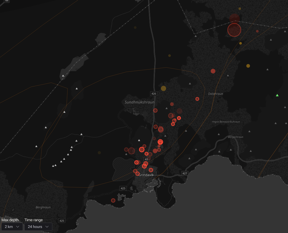
More quakes near Grindavik may also confirm the notion that the ground is harder to break up there, hence more quakes.
Oh and notice the two big ones way up north. They caught my attention. I’ve been scanning this area on maps and Google Earth. Looks like that rift system extends far more north but any craters there seem to have been largely eroded, or aren’t actual craters.
Thank you very much for this, Randall. I’ve been very, very curious ever since I saw the mention of fiber-optic cable being used this way, and you’ve given me what I’ve found nowhere else; a firsthand account of how it’s used, including that it can be used in real time.
https://twitter.com/volcaholic1/status/1724938759165087849
Video inside Grindavik
https://twitter.com/volcaholic1/status/1724808850820448700
NEW: Cracks have appeared in Sundahverfi, an industrial district at the eastern end of the Grindavík harbor, #Iceland. Responders are on-site, expressing concern that the cracks may widen. The neighborhood is currently closed, and Logi Sigurjónsson, the police officer and head of patrol in #Grindavík, mentions in an interview that the area is being considered for evacuation. The situation is under evaluation, and a formal evacuation has not been initiated as of now. The visible crack runs from north to south.
wonder if the power cable underground ripped which is why the eastern part still hasn’t gotten power.
They are on their way now to try to find the problem so they can fix it.
It has been discussed that the current Grindavik dike has magma solidified at both ends now, due to the time delay but the middle is still hot. Seeing that we have cracks in the town, can we assume that cracks occurred in the ocean to the SSW? Would sea water seep in? Would that water flash on exposure to hot magma (solid or not) ?? I am curious as to why we’re not seeing any phreatic reaction on the south end of the dike, assuming that the cracks would have allowed sea water to seep in
Oh, the entire dyke will still be liquid. Magma cools VERY slowly underground!
It depends on the thickness. At 4-5 meters thick, it will take a long time. But less than one meter will not last that long. Of course it depends on the original temperature and whether the surrounding rock surface has been pre-heated, but the thin end of the wedge could solidify in a week. Also, in a vertical dike you can get convection currents and that will transfer heat from the deeper areas where the dike is probably thicker.
Unlikely to cause a reaction. The ocean surface and below is already soaked in water to a certain depth, at least up to the first insulating layer. A crack might open it and allow water to sink in deeper but this has got to be at near-surface depths, certainly not at 4+ km depths where magma might be.
This wouldn’t be a sudden contact. The water would heat up and boil way before it comes into contact with magma, so it would slowly bubble up and not cause an explosive reaction.
Actually, as magma rises it will almost certainly hit some layer of groundwater. I’m expecting some of these craters to start venting steam initially, for minutes or hours, before there will be an eruption.
Steve, I think you’re right about ground water now, in the graben cracks, as water goes nowhere but down. If magma is 500 meters or less underground pretty soon we should start to see signs of steam. I do remember in the 2nd fissure eruption, the very first gas leaving the ground was steam and a lot of it. Finally the volcanic gases arrived.
A little review of the continuously recording GPS meters from
@Vedurstofan
and the UI show very clearly that the glide is quite stable.
East of the inlet are Gónhóll and Selatangir on the way to the southeast. Eldvörp and Svartsengi are on the west side and head northwest
https://twitter.com/danielfj91/status/1724921341764132995
Fiber optic-turned-seismometer in Svartsengi, all live on YouTube!
Very regularly, tremors appear there as diagonal lines up in the middle of the grave. Amazing!
https://twitter.com/danielfj91/status/1724885216638967974
So cool!
And another tab open….
according to this page: earthquakes are near vertical red lines, while noise tends to be diagonal: https://www.youtube.com/watch?v=MUt7Lz4y-jg
That is correct and that is what we observed.
It is worth the reader’s time to go the video channel and watch this fascinating piece of hardware in action. You can watch quakes live and even tell their location north or south of the cable and roughly guess the magnitude too. Several of us watched for a couple of hours slowly learning how this works and what tectonic signals look like. It was almost spooky watching the construction truck being tracked in real time as it moved, that’s how sensitive the new DAS equipment is.
A bigger quake (unverified as a 3.6, 3.6 km NNE of Grindavik, at a depth of just over 5km) is presumably undergoing checks now, prior to verification.
I notice that over the last few hours a large number of quakes have been centred on that spot, 3.6 km NNE of Grindavik, mostly at a depth of 4.5 km.
Some choke point being stretched open ?
…And it’s gone… No longer listed.
I suppose that’s why they need to be verified.
Situation 11 o’clock Icelandic Time according to RUV:
900 earthquakes since Midnight, some around Magnitude 2.5. Black Out of Electricity in eastern Grindavik continues.
One of the bigges bulldozers of Iceland has arrived near Svartsengi to build a great, great wall to make Texas jealous. 😉
Apart from that no chances, an eruption is supposedly going to happen suddenly.
I wanted to write “no changes”, got the wrong button …
Does anyone know how wide the new graben actually is? There is all of these different magma depth statistics, but knowing the width of the graben is going to tell you basically exactly how deep the magma is. It will be about as deep as half the width of the graben, so a narrow graben would mean the magma is closer. I guess eventually the graben just becomes a simple crack.
If I look at this map and scale, the graben (dark blue or violett) is around 2km wide:
The line of red dots (new quakes) shows well the graben:
Thats the area that has subsided but not necessarily the width of the actual graben, based on some of the images I have seen it is narrower than Grindavik js wide but exactly how much is unclear.
If you mean the magma intrusion aka dyke / dike / tunnel / etc … in that case it was said it’s at most 5 meters wide. I think that was info from the MET office.
Some write dyke, some dike, so I looked it up. Dyke is the British spelling, dike the American spelling.
That’s right. Personally, as a Swede, I learned British English in school, but then I’ve had a lot of influences from American literature and media, so I tend to mix it up. As long as others understand me I don’t really bother, but if I’m aware of the difference, I actively try to choose the British spelling.
I am Briti but my niece is Spanish and currently trying to learn English. She once asked me,”How do British children ever learn to spell the words correctly.” She finds it difficult precisely because she is learning from an American speaker.
Sorry posted befor finishing. I told my niece not to worry about mistakes in spelling as I would say to anyone learning English today, Very soon because of the internet I think that US English will be the norm and British English in the background. As Tomas says, the important thing is to be understood.
Yes – I have to pretend to be an American to win Wordle on some days. Spelling -our words as -or (valour/valor, colour/color) for example. I’ve also noticed some Brits saying zeebra instead of zehbra, so the US-ification is well underway. However, I’ve noticed alot of cross-pollination too – some Americans are now using the word fortnight (2 weeks) and mate (rather than buddy) in posts which is fun to see. As long as people understand each other then language serves it’s purpose, whatever form it takes.
The thing that drives me crazy is when someone will come up to a group of women in a cafe and say “Hi guys, what can I get you?” I tend to reply a trifle waspishly by saying. “I am not sure about the guys but us ladies would like….”
I have never actually seen dike written with a y, I guess I do spend most of my volcano watching time on the HVO site but even looking at other sources the spelling of ‘dyke’ has never appeared. Same as the spelling of sulfur, I am not American but the spelling with a ph has only ever showed up in my life when it is from an old source, it is just not spelled without an f now at least not in Australia today.
The one big thing about English that does separate it a lot from basically all other languages is that spelling is very arbitrary, despite how much teachers will say and act otherwise. At a glance that might sount helpful, but in practice it means there are many thousands of words that break the rules of the language, the only way to get these is literally to just remember them, which takes a long time. In a way that is more like some if the Asian languages, which are notioiously hard to learn second hand. English also doesnt invent words for things, we just adopt the local word for anything new, which only adds to the list of official English words that break the rules… 🙂
On the plus side, it is spoken everywhere and is easy to be exposed to, and unlike most languages you dont need any particular accent to speak English, most people will still understand you.
Chad, even the English teachers are very poor on English spelling nowadays.
My son when in primary school wrote about an aeroplane and actually had the word crossed out and written as airoplane! I had to go in to her and correct her poor spelling, telling her aeroplane is the correct British English spelling, airplane is the correct US spelling but airoplane is incorrect in both countries. She went red and apologised with poor grace.
Evidence please to support your assertion? A single, possibly overworked teacher, is not sufficient.
PISA would disagree: https://assets.publishing.service.gov.uk/media/5f20292e8fa8f57ac3af2d11/PISA_2018_England_Exec_summary.pdf
‘Dyke’ is a very derogatory term used for female homosexuals here in the U.S….on par with the *N* word.
It was used much more decades ago, but it’s still in use by the more ignorant segment of our society.
Out of respect (and political correctness), I always use/write Dike.
Interesting. Didn’t know that. Kike I knew (derogatory for the Jewish) plus frog and kraut.
It looks as if finally also Grimsfjall / Grimsvötn has got a positive trend since summer:
My VC article is not fully complete.. so woud be fun to edit it in VC when its posted as a draft, many words needs to be improved and better formulated
Im very busy and there will be more articles later from me
Hi folks,
Anyone see steaming moss between the main road and main road?
Thanks
Richard
Between power plant and main road
Just beyond the road in the foreground on this cam ?
It was steaming (or smoking) throughout the last night.
If it were caused by magma I think it might have broken the surface by now.
https://www.youtube.com/live/HVMSDGRXyuc?si=Gv3QHd0p_9KFSSKb
Yes that’s the one
I’d guess it’s hot water from the power plant.
Maybe it’s is a leak from the Blue Lagoon 😉
I’m kidding of course, but to be honest, there are hot areas all over the place where steam is coming from the ground. It’s a very common thing here in Iceland.
It can look similar when an eruption is about to start, but only for a few minutes, then you’ll see fire, it’s no doubt when it happens.
I agree.
Based on the previous Reykjanes eruptions, if you’re watching the cams and you think you’ve seen something ?
Slow down… breathe… wait 5 minutes…
If there’s still any doubt at all… If it ISN’T spewing flame and lava ?
No eruption.
There will be no doubt.
Iceland is magnificent really! I will move there as nordic citizen when I found a job skill that suits me, and its pretty mild too in Iceland at least around the coasts, the worlds wamrest winters at latitude 63, its the cool summers that often makes icelanders leave for the other nordics for summer work, but Iceland is proably going to warm up alot in the comming decades, and already getting quite warm in summers compared how it was in the early 1900 s
I would love to visit Iceland but I could never live there. I MUST have a garden to care for as it helps a lot with my mental health. Sadly I havent seen gardens in Iceland and it is probably hard to make a garden in most of Iceland as the mercurial changes of weather would make it difficult for all but very tough plants.
There are gardens, and of course you can always get a greenhouse It’s relatively cheap to keep it warm and during the darkest months you can use lamps, then you can grow just about anything.
Thanks for that reply Hildur. I hadn’t thought of greenhouses, probably because my own one is now maily used for wood storage in the winter and on the south coast of England a greenhouse is not really a necesity anymore. 20 years ago I used it a lot but winters have now got so warm down here that there is seldom a need to overwinter plants in a greenhouse. 30 to 100 miles north is a different matter and Scotland can get very cold on the Eastand North,
Compared to Canada and Russia, icelandic places at least Keflavik and Reykjavik and Westman islands are very warm for soure for their latitudes, its all warmed by the nearby atlantic gulf stream waters, while sibiera have – 50 in winter, Keflavik can have +7 c in january at same latitude due to strong marine moderation, but that marine moderation also means that summers are mild too, while the other places have extreme heatwaves in summer. Typical high summer temperatures in reykjavik is around 14 to 20 c and the interior in Iceland gets even warmer summers, but much colder winters. Iceland is mild marine climate around the coasts and the clouds and drizzle and green moss is a major part why Iceland looks so otherwordly when thats combined with volcanic glacial landscapes.
None of the summers in Iceland is as good as the other Nordics.. but the other nordics expect perhaps Norway haves really insane nature.
The unique geology draws me to Iceland, the mid ocean ridge and mantle plume combination and glacial – volcanic landscapes is rather insane and Iceland is among the most powerful oceanic magma sources togther with Hawaii, having a nordic citizenship is pure gold if I wants to move to Iceland.
Correction none of the other nordics expect norway does have nature that comes anywhere close to Iceland, althrough tall forests are common in Scandinavian mainland and brings pepole alot of pleasure.. but Iceland is otherworldy
Jesper I know from experience that at higher latitudes there are many biting insects. In Scotland I have experinced camping in a wrong area and getting eaten alive by midges so badly we broke camp at 3:00am and drove away to escape. Do you know if Iceland has the same problem in the summer? I know the northern area of Scandinavia does. A Norwegian friend told me that in the far north the midges and biting insects cant be called insects but should be reclassified as animals. 🙂
Not alot of mosquitoes in Iceland… infact none.. but Scandinavian mainland is moquito hell and specialy the cold northen part
just my two cents. I noticed that a couple days ago and it doesn’t look like it has changed much. My guess is just a local, natural hydrothermal vent.
https://twitter.com/volcaholic1/status/1725141968131366949
Mount Dukono in #Indonesia erupted on November 16, 2023, at 12:01 WIT, with an ash column reaching approximately ±1200 meters above the peak (±2287 meters above sea level). Over the past two weeks, Mount Dukono has been undergoing its biggest eruption in eight years. Despite the intensity, the impact has been relatively confined, with Tobelo City experiencing 3.0 cm of ash over a couple of days.
More scenarios to consider:
https://www-mbl-is.translate.goog/frettir/innlent/2023/11/16/thorvaldur_bendir_a_eina_svidsmynd_til_vidbotar/?_x_tr_sl=is&_x_tr_tl=en&_x_tr_hl=en&_x_tr_pto=wapp
Awww … these translations. Sometimes I wonder whether the Icelanders are purposefully mocking us. 😀
“preparations are being made for soda, and with the same continuation, the system should be good for soda after about 10-20 days.”
“old weaknesses are being used. The flamethrower is naturally one such weakness.”
“The same goes for any model accounts or soldiers. They are only as good as the assumptions you have.”
To sum up the article: Anything could happen. We have absolutely no idea!
I laughed about the soda too and wondered do they not have popcorn to go with it. Icecream soda is my go to choice.
Nobody knows if it’s going to erupt or not. And nobody knows where exactly it’s going to erupt, if it comes to that. And nobody knows when.
So yes, “anything can happen” is the situation right now.
I especially liked
But which Eldvorp appears to be the burning question?
The one behind his ear obviously. We need cameras on this man at once! 🙂
🙂 🙂 🙂
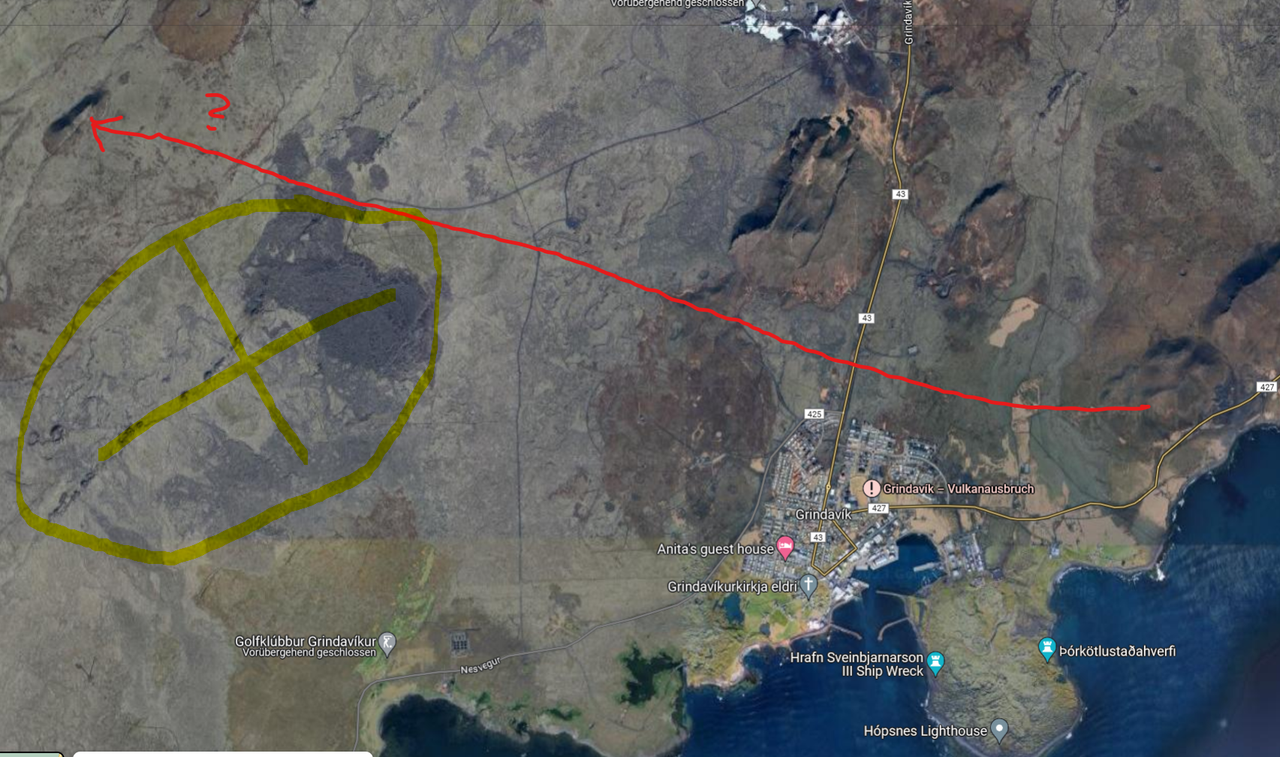
There is no question which. It’s a 10 km crater row to the west of Thorbjörn. I don’t understand the confusion, this is pretty straightforward, this has been talked about the whole time since the sill started to grow. The only surprise was when the sill suddenly emptied towards Sundhnjúkagígar, that was the big surprise. Everybody was talking Eldvörp before that happened.
Sorry Hildur. I had got it very wrong then. I had thought the area we were watching was closer to the power plant and blue lagoon. Clearly I got that wrong.
There was a failure in the main electricity input to part of Grindavík, and preparations are being made to repair it.
Sadly it appears they may not be able to repair the electricity problem in Grindavik.
Electricity went out in a large part of Grindavík just before 5 p.m. yesterday, as mbl.is reported at six o’clock yesterday.
“It is clear that the distribution system is damaged in many places and there are failures in more places, and it is still uncertain whether this will be resolved,” says the announcement from HS Veitum.
For some reason I can’t reply to your last comment Alice so I’ll do it here. You are not wrong, the northern part of the crater row Eldvörp does end not far from the Blue Lagoon and the power plant. But the rest is far from everything which explains why nobody was worried about Grindavik in the beginning.
I don’t know how to embed photos here but here is a link which shows Eldvörp as item no. 6 on the map and you can actually see the crater row. It’s bigger than Sundhnjúkagígar, now wonder they named it “Flamethrowers” (yup, it’s plural).
https://imgur.com/a/6Ks60c3
Many thanks Hildur.
A power company’s nightmare, the weak part of underground distribution systems is when the ground moves.
Speculations on lava flow directions, with a useful annotated map
https://www.mbl.is/frettir/innlent/2023/11/16/svona_er_hraun_talid_myndu_renna/
And don’t know if this has been seen here before: map showing what I assume are the sides of the graben in yellow:
https://www.mbl.is/frettir/innlent/2023/11/16/kort_kvikugangurinn_og_sigdalurinn/
Looks like the low frequency tremor is dropping, as it did a day before the last big event:

Helicopter just landed in Grindavik. Just hope nobody got hurt during the trip into the red zone.
Helicopter just now left. Perhaps an inspection team for the electricity repairs? They didnt stay long enough to do repairs by the look of it.
Sounds like a parts delivery.
Impressive! The lights are back on in Grindavik!
https://twitter.com/DottirGongu/status/1725170530150400415
How could the signal of the beginning of the eruption be shown?
If a tremor pulse begins (constant vibration of the ground due to the outflow of magma) we can expect a signal similar to this example
Start of the tremor El Hierro eruption in 2011
Thank you! Thank you! 🙂
That is exactly what I needed to know! What I’ve been trying to figure out the past couple days.
Now I can sit back, relax, even work while having this DAS graph nearby in eyesight on my iPad and I won’t miss a thing. Such a relieve! 🙂
Whoa! Not quite, the 2nd graphic is a discrete Fourier Transform waterfall display from the SHZ channel of a regular siesmometer, not the DAS display. We’re going to have to ask the DAS people what tremor looks like on their type of displays.
No tremors above magnitude three for two days
Earthquake activity has continued on the Reykjanes Peninsula for the last few days. However, they have all been under magnitude three. No earthquakes have reached that size since before noon on Tuesday.
Posted on RUV today….
There were about 1,200 tremors from midnight to 2pm today.
Despite less seismic activity than before, the risk of volcanic eruptions has not decreased.
“Due to the release of tension, it is likely that the magma will have an easy way to the surface, and therefore it cannot be assumed that eruption turbulence will be visible on the meters before the eruption begins,” reads a post on the website of the Icelandic Meteorological Office, suggesting that there may not be a very great deal of warning before any eruption.
They are essentially repeating what was said on Friday/Saturday. Something along the line that it’s possible that there may be little to no warning ahead of time.
Perhaps they need to say that? Because: insurance claims. Nobody told us it could be HOT! 🙂
New webcam by http://mbl.is on Thorbjorn looking E to Hagafell
English interview with the Icelandic vulcanologist we’ve seen a couple times recently. Yes, he speaks english rather well. 🙂
https://www.ruv.is/english/2023-11-16-ruv-english-radio-thorvaldur-thordarson-volcanology-professor-audskilid-397342
It does look like the deflation of the sill is done, and the magma is refilling it again.
Looks like the sill is filling up again relatively quickly. I think this is the reason some scientists think there is a possibility of an eruption in Eldvörp, since it is the closest, closer than Sundhnúkagígar actually.
Yep, close to 4cm uplift in 4 days, a rate similar to the inflation prior to the breakout into a dike.
So in the absence of other reasons for uplift, the intrusion source would still be introducing magma into the sill at the same rate. If that rate is maintained without eruption, then the sill will take 40 days to inflate to the point it was at prior to something giving way and the dike breakout.
Similar rate? I beg to differ! 😉
Just by looking at the relations of the last data point (the yellow one) to the one below I would say the current inflow rate is at least 30% higher!
About the image: I cut out the five new graph points from the bottom and overlaid them in two places over the graph’s previous days at two locations. I just used some transparency so you can see both, which explains why the dots seem more faint at these locations.
Yes quite possibly faster rate of intrusion, especially if magma is also leaking out into the dike.
But as it is only four data points and the ground deformation means that bit of crust above the sill has now bounced around like a yo-yo, it is probably best not to draw any conclusion beyond “similar” for the time being. 🙂
Two questions here. Were you using the last 4 data points on the up channel to extrapolate to when the trace would cross the zero line? If you used volume and magma inflow rate in m^3/sec, could you outline a bit on the volume fill calculations? I hope you don’t mind me asking.
Just using the uplift figure over the past four days without conversion into flow rates or volumes.
At a cm/day we will reach the same GPS recorded position before the breakout to dike formation.
All things being equal we would expect the pressure in the sill at that point to be significant enough for the pooled magma to again be testing the strength of other nearby faults or the the current dike if the the feed to it is still open.
All things are not equal however, so i’m basically comparing apples and pears for the “what if” fun of it – hence why i’ve not bothered trying to work out a rate of flow or volume. If the feed to the sill is still similar to previous days and the feed to the dike is still open, then something will likely give much, much sooner rather than later.
Hildur, am I correct that an eruption at Eldvorp would be the best option for the likelihood that Grindavik could be spared from lava?
I think so, it would be the ideal situation. Maybe even another tourist attraction.
Looking at the (almost) past three years that is quite the hockey stick graph!

FYI graphs are located here: https://brunnur.vedur.is/gps/eldfjoll/thorbjorn/
If there’s a better overview / gallery for these please let me know.
Police are running around Grindvik with their lights on again.
https://www.youtube.com/watch?v=YAQzsB9ev9Q
What happen? Red Lights.
They have been there at least since early afternoon. I wonder if they are working there on repairs as they are now allowed in to do repairs to roads and other utilities.
Hey! The power’s on!
My best guess…
In the absence of normal street lights, they’re rigging emergency lighting to key areas.
they were moving safety deposit boxes from bank at one stage, there are probably other things that need to be moved or made safe elsewhere
And all the documents from the town hall.
Somebody set up us the (lava) bomb. Obviously. 🙂
Is there a camera overlooking the Eldvörp area (North-West of Grindavik)?
The Grindavik-camera seems to be located on the eastern side of the white container @ Thorbjørn mountain, so it won’t be able to pan further to the right (west) to overlook Eldvörp. Perhaps there is another camera located on the western side of the white container? If so, does anyone got a link? 🙂
First camera on Live from Iceland – Svartsengi. It’s a wide angle view but covers the area west of the Blue Lagoon
Thank you! Wish I saw your comment before I posted my camera map 5 minutes ago (still awaiting moderation before becoming visible) 🙂
This one pans further to the east but not past the telegraph towers:
https://www.youtube.com/watch?v=PasUycyE96o
I also recommend this one on Husafjall as it overlooks the entire north-south span of the crater series under which the magma tunnel lies.
https://www.youtube.com/watch?v=HJWj-1RIIgM
You can look past Thorbjörn to the left all the way to the end of the peninsula, and I think the first two elevations to the left of Thorbjörn are Sandfell, just behind Eldvörp. It may not be as close but at this point I refer to it as the “catch-all” camera. 🙂
Red line is approximate line of sight. Where it bends must be a tiny black hole, ignore that. 😀
First of all: I don’t know if posting an image like this works at all, if not I hope the dragons can help me!
Someone requested a map with camera locations, and I have given it a go; very unscientifically! The camera sectors are just guesswork/approximations, and I’m sure there are multiple cameras in the area which I have not included (these are just the ones I’m following myself at the moment).
Here goes:
Links to the cameras:
1. Sylingafell: https://www.youtube.com/watch?v=Qvw5qh5K4wI
2. Langihryggur, 6. Reykjanesviti, 5. Thorbjørn (South, Grindavik): https://www.youtube.com/watch?v=804nPrAUAxg (multicam)
3. Thorbjørn (North): https://www.youtube.com/watch?v=P1e_MWJ1nQc
4. Thorbjørn (East, Hagafjell): https://www.youtube.com/watch?v=BerZJunvSik
Good stuff – is it possible for a dragon to pin this image to the article?
Yes, I’ll add a new links page with this information in a bit – it’ll sit outside of the posted articles so it doesn’t get lost in any updates. I’ll add it to the top menu bar and remove the page for the Taal eruption that’s not needed at the moment.
Many thanks, Tor for producing it.
Tor – If there are any updates/additions to this graphic, please email them to the VC mailbox and I’ll update the links page as soon as possible.
I sent an updated map @ email just now.
Thanks Tor, I’ll update the page tomorrow after some much needed sleep 🙂
Just a reminder to update the graphics to the one I sent in the email yesterday 🙂
Thanks for the new page by the way! It is very handy indeed with the links to the plots etc!
Happy to help!
I think my pic/map should just be seen as a rough draft and more cameras and locations added as well.
Steve suggested the Husafjall camera (https://www.youtube.com/watch?v=HJWj-1RIIgM) too as it “overlooks the entire north-south span of the crater series under which the magma tunnel lies”, and eccentric_viewer pointed out that the Svartsengi camera (https://livefromiceland.is/webcams/svartsengi/) points at the Blue lagoon and Eldvörp area.
I think the best solution would be if the dragons could create a static page with links to a dynamic map with updated camera positions/links for future eruptions.
Users could then suggest relevant cameras and describe their sectors, and the dragons could add them to the dynamic map for the current and relevant intrusion/eruption. Just a suggestion 🙂
Tor – could you send me the editable graphics file, please? If you could add those two new links and the angles, I would be very grateful. I’ll add any additional information from that point on.
Many thanks to Tor for producing this map of cam links and locations and many thanks Beardy for offering to keep these links up. I keep intending to bookmark them but the bookmarks were getting muddled.
A bear of little brain here! I used to have a good brain but during the last 20 years of my wanderings, and wonderings, I appear to have misplaced most of it.
I put my brain decline to having two young high-needs boys and the resulting sleep deprivation and stress… the joys of parenthood! 😆
Sulfur gas coming out of one the the boreholes in Svartsengi:
https://www-mbl-is.translate.goog/frettir/innlent/2023/11/16/brennisteinsgas_maelist_i_svartsengi/?_x_tr_sl=is&_x_tr_tl=en&_x_tr_hl=en&_x_tr_pto=wapp
https://twitter.com/DottirGongu/status/1725219988070441291
A tad ominous to say the least.
It is not what you want to have yeeting out of a geothermal borehole that has not been purpose drilled into a magma reservoir.
H2S is though quite normal.
The DAS display of the 17:46:51 mag 2.66 quake very close to Grindavik at depth 1.9 km. This is quite shallow.
See
They’ve detected magmatic gasses in a borehole in Svartsengi north of Thorbjörn. Lovísa Mjöll Guðmundsdóttir (IMO) says that this is the evidence for magma in this area. The borehole is east of Grindavikvegur (Grindavikway) and goes towards Sundhnuksgigar, it confirms that Magma is below the north of Hagafall. The likelihood for an eruption continues to be high. (RUV)
How wide is the borehole – would magma erupt through it or likely solidify?
One of the boreholes at Bjarnarflag briefly erupted during the Krafla fires.
Yes, it did an artificial phreatic eruption/explosion. But I believe that they put water in the pipe, which acts like Nobel’s Dynamite in contact with magma.
That doesn’t sound familiar. I’m talking about the eruption at B-4 on 8 Sept 77 – it lasted about 20 min and produced about 3 tons of scoria, if memory serves. I probably have the paper on it somewhere.
That’s above my knowledge … maybe there would some bombs/drops push through and then it’s over?
This graph shows the sinking of the graben since last Friday. -25cm is nearly like sea level rise in 100 years.
Looks like the beginnings of a fissure in the distance on the new MBL Hagafell cam.
Have you got a link? Thank you.
I was perhaps a tad too hasty with my observation but I’ve watched an orange area distinctive from the city light pollution develop in the centre of the frame over the last 20 minutes. https://www.youtube.com/watch?v=BerZJunvSik&ab_channel=mbl.is
Watch the latest Kilauea eruptions from Haleumaumau. They were fortunate to start during late night / early morning, and the light levels blew out the capabilities of the video camera.
So far on RUV’s webcams I only see artificial lights. An eruption would be like a dragon. If you don’t see the dragon, it’s not a dragon.
/This comment is approved by the Guild of Dragons!
This camera? https://www.youtube.com/watch?v=HJWj-1RIIgM
I can only see the lights of Grindavik and Keflavik with very little in between save for the greenhouse.
If/when it does erupt it won’t sputter out, it will blast outwards through a narrow spot under high pressure, and you’ll see a fountain of bright light.
It will be a Sun on the ground, and will wash out more pitiful light sources.
Remember how quickly this all developed ?
Someone on here said (of a camera view ) “That looks a bit smoky”, and within an hour there was a full blown fissure.
https://youtu.be/yanlRDo8kkU?si=5dBFTrhPiQSqTg_y
Faster than that. First smoke was seen on the RÚV cam at 16:41. At 16:42 I commented “it starts now”. Jakob Vegerfors took one of his first drone pictures at 16:47, and at that point there was already a fully formed fissure, curtains of fire and all.
These things don’t smoke for a while before starting. They just start. I reiterate the rule of thumb: if you have to ask, then it didn’t start yet.
https://twitter.com/Icevolcanx/status/1725224785251041359
Latest from IMO
Magmatic gas is measured from a borehole. Confirms the presence of magma in the Earth’s crust
Land subsided by 25 cm in the center of the valley in Grindavík
Updated November 16 at 17:50
The seismic activity at the magma dike has remained fairly constant between
If a small eruption starts outside the thin red line, or a medium-sized one starts outside the thicker red line, then models show that the lava would not flow into Grindavík.
I love that “gos” have so wildly different meaning in Swedish and Icelandic.
In Swedish “gos” means: To cuddle, or, To fluff (with someone)
One pretty picture can’t hurt. The one above the article is more a documentation.
Hopperian
Maybe he needed an early night and didn’t want to wait till it was dark. Or perhaps there was a power cut then, too.
You’re welcome! 😉
Tajogaite, La Palma, 2023
I have a crazy hypothesis.
What if this is the beginning of a shield eruption?
Let’s see:
– first a huge volume of magma intruded
– But a graben formed and allowed for that magma to fill a lot of space
– now the rise of magma is very slow
– if it erupts, it will erupt at a slow rate but the large volume of magma could feed it for a long time
– Reykjanes peninsula is peppered with several shields from previous eruptions.
– Some shields are associated with graben valleys
not so crazy, really. We knew in 2020 that Mt Torbjorn rose up.. but then this gradually faded away in our memories as new inflation events occurred, now suddenly blooey, the sill gives way and created a rather large graben, but we’re back to the normal recharge rate from the mantle.
*** Important Information ***
I’ve created a page, separate from the published articles, with links to important information for the current notable event – In this case Iceland (obviously). The link can be found on the top menu bar, or the link below if you’re too lazy to scroll up 😉
https://www.volcanocafe.org/ongoing-events/
If you want to submit additional links/graphics or alterations, please send them to the VC mailbox (volcanocafe.org@gmail.com) and I’ll add them as soon as possible. Links and content in the comments will get easily lost and I don’t have enough hours in the day to peruse all of them for updates.
Many thanks. found it easily.
Thank you Gaz, much appreciated.
this is great, thanks a bunch !
Big thanks.. very helpful to have this kind of information around.
Oh, well done!
The ‘where the webcams live’ graphic is great – thank you 🙂
Great, thx!
Really nice!
The link to the live DAS waterfall plot could go there as well. I absolutely love rhis piece of technology. If you have an optic fibre, then you can use it as a few hundred or thousand seismometers placed in an array. Basically, every segment of a few meters of fibre becomes a broadband seismometer.
https://www.youtube.com/live/MUt7Lz4y-jg
I really must learn about DAS, I seem to have missed a cool new toy that could be very useful when doing ultrawide arrays.
And far cheaper than the node-crap that does not even work as well… 🙂
Many thanks Gaz and also Tor for the annotated web cam map.
I know Carl didn’t want to draw the mechanism of graben formation above the dike. Someone else tried. Have a look if he succeeded?
https://twitter.com/spahn711/status/1725266960106025361
Mechanism is known, however Iceland has high magma rate production compared to other parts of MAR, and many original parts of grabens are later flooded by lava. With slow spreading rate 2cm/y graben in Iceland should look like broad rift with many fissueres.

https://www.sciencedirect.com/topics/earth-and-planetary-sciences/mid-ocean-ridge
It is here good to remember that the Graben is not on the spread axis, so the 2.8cm spread rate will have far less of an effect compared to other factors.
The spread is quite a bit lower in Reykjanes than the total spread rate of 2.8cm year.
It is more of sideways movement than a spread really at this part of Iceland, and that is why there’s so much pent up strain.
More about that tomorrow.
The comment chain has exactly the data I was looking for, the dimensions of the graben. At Grindavik it is about 2.5 km wide, getting wider towards the ocean. It gets narrower to the north. That means at least initially when the intrusion was happening fast and nost of the subsidence was occurring the dike was probably about 1 km deep kr a little more, it may have been rather shallower further north closer to where the swarm began. Basically, I think it very nearly erupted immediately at Sundhnjukargigar but instead it brome laterally and created the long rift, so one could call it a failed eruption although that wording is poor as it is still far from over.
What this also means is that I think an eruption will probably happen further inland than is currently discused. That being said, the eruptions from Fagradalsfjall didnt seem to really make grabens, even the one in July which was wuite fast at its onset and similar to what is expected now. So magma movement after the major rifting may not conform to the half graben width trend.
But I am placing my bet on an eruption a bit further north along the dike from Hagafell, near where the origin of the dike was back on the 10th. Grindavik should be safe although the power plant may be at risk if it flows that way.
Sorry, but the Graben is definitely not 2.5km wide.
It is also fairly consequent in its width across the length of the dyke from the Mar and tapers towards the end somewhat.
This was the first image I have been able to find that actually gives dimensions in visualization. I am happy to revise the numbers for other images. The main point is that the magma is more or less as deep as half of the width of the graben, so a narrow graben is not a good thing.
I am still going to keep my guess of somewhere around Sundhnjukur and going north from there as the most likely eruption point. We will see who is right eventually I guess 🙂
It is roughly half as deep as it is wide.
At least going by the model by the University of Iceland giving it a depth of 400-500 meters.
I am quite open to it coming up at any point along the dyke, but I see slightly more reasons for it coming up at around the second Eldvórp at Grindavik than at Sundh…
In the end ir is more about where it will find the weakest spot, and that is dang hard to predict without having borehole data along the entire length of the dyke.
HVO had a Volcano Watch article about it. In 2018 the magma came up to about 50 meters below the highway 130 to Kalapana. It didnt form an obvious graben in this location but the edge cracks were still visible and about 100 meters wide. It didnt erupt there because magma pressure increased at the east end and the intrusion went back downrift, but SO2 and surface cracking was seen even west of the road and uprift if it. It was probably within an hour of surfacing at that spot, but Pele was more interested in Kapoho I guess, and set her sights in that direction thereafter.
Also of importance, in the year following the 2018 eruption much of the area where the dike was shallow but didnt surface ecame strongly fumarolic and saw significant die off of the vegetation, and very high ground temperatures. It is still like that now, I was able to see it personally last year.
This may well happen in Grindavik in the future abd present a big problem to its continued viability as a place to live, even without eruptions anywhere within it. The Sundhnjukur fissures didnt really go into Grindavik, there is a minor vent probably active for under an hour to Grindaviks east, and a similar vent way up the other end of the dike swarm amongst the lava of Þrainnskjoldur, but most of that eruption 2400 years ago was from the middle part of the fissure system at Sundhnjukur and Sundhnjukagigaröð. That doesnt mean the same will be the case now but it seems likely the dikes will extent quite further than the surface fissures by some distance in any case, at least when the land is flat like it is there. Grindavik may be safe from eruption within its boundary but it could still see lava flowing from inland vents.
Actually, there will be an article tomorrow explaining the Graben, the Dyke, how they are related, and what happened.
It will be a graphics galore…
BBC News showing their helicopter ride over the town today, including the work being done around the geothermal plant, blue lagoon etc.
https://www.bbc.co.uk/news/av/world-europe-67445280 Link to report.
Thank you.
There must be at least one species of tree/shrub which will grow in the Icelandic wastelands. The houses surrounded by nothing, only emphasise the barrenness of the place.
https://icelandtravelguide.is/locations/hallormsstadaskogur-forest/
Thanks Talla. That explains the helicopter I saw land in Grindavik and then take of around 30 minutes late. I had thought it was to do with repairs to the electricity supply that they tahamkfully managed to repair soon after.
OOPs. my comment above got misplaced. As to flowers in Iceland the only ones I have seen growing naturally appear to be a species of purple lupin.
Icelandic forests used to be mostly birch. They were almost all cut down pretty early after settlement but the little ice age probably made it a lot harder for it to grow back too. I expect Iceland might start greening up a lot in the coming century.
Large parts of Reykhanes were probably always barren though, it is the youngest part of Iceland and one of the only parts of the (formerly) forested lowlands that gets frequent resurfacing. The area around Hekla and the outwash plains below Myrdalsjokull and Vatnajokull are the other main areas, though the latter two are much more due to floods than lava.
: ) I wonder how fast it woud green IF it coud be placed at the equator on some current sea area, remeber that Krakatau caldera rim turned into a mature rainforest in less than 101 years after the eruption. I wonder how fast Vatnajökull woud vanish under the equator sun 🙂
On some warm current area for correction for extra humidity, but the volcanic – glacial landscapes woud be history rather quickly
Taiga areas have low evaporation rates at least the mainland, that means that quite little moisture is needed for a humid climate, the taiga forests are acually as dry as many deserts, just that the lower temperatures here means that the water stays as water that exist and is not evaporated so explains why these areas are not deserts, and water condense too in the lower temperatures here.
Scandinavia and Iceland thats more coastal borders on Taiga and a Taiga – Cold Rainforest as classification as we are not as dry as the siberian and canadian taiga in anyway in the large continetal interiors
A group of us on the ETH Zurich DAS youtube channel have been discussing what volcanic tremor on the DAS display might look like. This search has led to the following information – a video by Sara Klaasen explaining what they did on the Grimsvotn volcano see https://www.youtube.com/watch?v=t8vlp9iqmK0 and the research paper is at https://www.research-collection.ethz.ch/handle/20.500.11850/635799
Sara is part of the same group ETH Zurich which is now monitoring the fiber optic line from the geothermal plant down to next to the ocean.
I admit as a retired aerospace engineer that I am impressed with this new technology and its potential.
I am also quite impressed since it would give all sorts of abilities in my field of geophysics assesments of deep geothermal fields.
I should really one day have to sit down and have a chat with her.
If I can encourage you, please do that, Carl.
Oh, after having looked at it for a few days now and read the paper, you bet I will.
Either you stay on top of technological development and new methods, or you will be blown out of the water (literally in the case of super-critical geothermal) 🙂
https://twitter.com/naspmon/status/1725282973883183107
This is quite interesting Luis. Tomas gave me permission to run dft waterfall analysis on the FEFC data prior to the July 10, 2023 eruption at Litli-Hrutur. Tomas definitely is in the lead here, at NASPMON, on trying to do more scientific research on harmonic tremors and fissure eruptions. They are trying to get a better grasp on how we can anticipate a fissure eruption.
Thanks!