
Solfatara. The earthquake swarms are focussed between here and Pozzuoli harbour in the distance
I loved Naples. It is a lively Mediterranean city where there is always something going on. The people are amazing. I was told (a long time ago) by someone whose wife was from there that they were visiting the city, and his wife went somewhere and had told him in no uncertain terms to stay with the car. Which he did, but not at the car -stretching legs, walking a bit, always within sight of the car. When he came back, sure enough, the car had been robbed – unseen by the watching wanderer. You have to admire them. When I was there I was told which particular street to avoid if I valued my life, and had no problems – perhaps because I did not bring a car! The city is sandwiched between two volcanoes: Vesuvius, an excellent tourist introduction to what a volcano should look like, and Campi Flegrei, looking nothing like that. As Hendrik pointed out to us many years ago, the danger is in the hidden one, in typical Neapolitan fashion looking for an opportunity to erupt unseen while in full sight, like that unknown Neapolitan robbing the car.
The most recent eruption in Campi Flegrei started off-shore before migrating to land. It produced a nice new mount on the coast, did a lot of damage to the nearby area, wiped out an old harbour and caused half the population of Naples to flee towards it to have a good look – while it was still erupting. This all happened in 1538, and is described in a recent post. This was the first eruption (as far as we know) in 3000 years, was relatively small and was preceded by months (or years or even decades) of earthquake swarms. There had been plenty of warning. The first recorded earthquake swarm was in 1470-1472. After that, there was inflation, just a few meters (!) at first but eventually reaching 14 meters. There were a few more earthquake swarms, but they accelerated about 18 months before the eruption and became damaging in the months before the eruption.
After 1538, very little happened. There were major earthquake swarms in 1582 and 1594, but that did not lead to eruptions. Nothing significant was reported for centuries afterwards.
Of course, there were other problems. The area suffers from uplift and deflation -bradyseism- of up to 12 meters – the old roman town is now that far below sea level. One of the Roman towns in the area was at Pozzuoli, in the heart of Campi Flegrei. The unstable leveling was possibly one reason why it didn’t age well. A new city was build further down the coast, away from the unstable ground. This was called ‘New City’ of NeaPolis, which became known as Naples. (Actually it was ‘new’ compared to a hill side settlement much closer to modern Naples, but it is a nice story.)
The instability came back to Pozzuoli in 1950, after centuries of rest, when there was 70cm of uplift over two years. And in 1969 locals again began to notice uplift on the shoreline, affecting bridges and wharfs. Measurements confirmed that between 1968 and 1970, there had been almost a meter of uplift. There were minor earthquake swarms in 1970/71, too small to be felt. Things quickly calmed down again. (There was a suggestion that some of the earthquakes that were detected later in the 1970’s were actually from fishing with explosives!) But in 1982, uplift resumed and in May 1983, earthquake activity restarted in earnest with a M3.4 event. Over the next two years, there were multiple swarms with events reaching M4.0. Uplift over this period reached 3 meters. People were evacuated. But again, things calmed down and by 1990, measurements showed some deflation. Obviously there was no problem. Never mind that this was first time since the 1538 eruption that there had been such uplift and earthquake swarms – Naples deals with the present, not the past, and whatever happened a decade before can not be important.
But it did not last. Subsidence came to an end in 2005, and over the 20 years since, activity has increased – slowly enough for people not to readily notice, but the INGV (Osservatorio Vesuviano, with a notable naming focus on only one of the volcanoes under its remit) was on the case. They have installed many monitoring stations and produce regular bulletins. Over the past few years, casual observers have also been able to notice the changes. Solfatara is more active. Earthquakes are becoming more frequent. The sea is falling.
Let’s first look at the region. The map below shows the Naples area with Vesuvius, Pompei (of course) and other famous locations. The red oval shows the (very) rough outline of the overlapping calderas of Campi Flegrei.

The next map zooms in on this caldera. It shows the location of the volcanic features (old eruptions) of this region, all of which happened after the last major explosion a very long time ago. The 1538 eruption, Monte Nuovo, is number 9 on the map.

The must-have map of volcanic features of Campi Flegrei. Click on image for full resolution. Monte Nuovo is number 9. The current seismicity is centred around number 25. Solfatara is number 23, just above it.
Earthquake swarms
The earthquake activity after 2005 was initially minor, and shallow at 2 km depth or less. From 2012 it became more intense and since 2020 it has really taken off. The plot below comes from the monthly bulletins of the INGV and includes events up to April 2024 (so not this month’s swarms). It shows the rapid increase in number, and also the large increase in energy since 2023. The depth of the earthquakes remained initially around 2 km but more recently has also occurred at a depth of 4km. Much of this bradyseism, by the way, will be due to the sloshing around of underground heated water/steam. The hydrothermal system extends to 2-3 km below the surface and sees the effect of extra heat.

The swarm in October 2023 saw a M4.2 event, possibly (?) the largest Campi Flegrei earthquake for centuries. May 2024 saw this surpassed with an M4.4. (It was advertised as the ‘largest since 40 years’ but the largest one 40 years ago was ‘only’ an 4.0)
Earthquakes are mainly from three locations. One is an apparent fault in the middle of the bay, slightly curved. The second is the Starza fault along the coast, stretching from Pozzuoli eastwards. More recently, the earthquakes have been along only part of this fault, at the eastern end near Solfatara. Note that earthquakes in swarms can be hard to localize precisely.

High quality volcanic-tectonic earthquakes for the period 2005–2019. The size of the epicentres are shown as a function of the magnitude according to the legend on the bottom right. https://adgeo.copernicus.org/articles/52/131/2021/
What is the significance of the depth of the earthquakes? The events at 2 km occur at a calcium-rich cap layer. This is a thin rock cap later that separates the sedimentary layer below from the volcanic deposits (pyroclastics) above. Gasses and fluids rising from below get stuck against this cap: this hydrothermal stress bends the cap elastically and this causes the earthquakes. 2 km is about the depth where water can become steam, so it is likely that this earthquake zone is due to water vapour collecting below (and breaking through) this cap.
The sedimentary layer goes down to about 3km. Below this is the bedrock, affected by the heat from below, with another cap-rock separating the two. Since 2020, more of the earthquakes have been taking place around this deeper cap or even the bedrock below it. This may be mainly caused by CO2 degassing of magma. Magma intrusions have tended to stay within the bedrock and solidify there. The liquid magma is deeper down, at 7 to 8 km. (There is also a much deeper magma reservoir.) If magma is rising in significant quantities, it is likely that we will see earthquakes to this larger depth of 7-8 km, which we do not do at present. It is however possible that some magma did rise to 3 to 4 km in recent episodes: it has been proposed that the pressure increase was caused by the emplacement of new sills in 1950, 1970 and 1980. However, there was no proof that magma has collected at this depth – but see below.
Arise
The current activity is comparable to the events of 1983 and 1984, but with a much longer build-up to the activity. Since 2016 there has been uplift of around 1 meter at Pozzuoli (1.2 meters since 2005). The figure below shows uplift since 2021, accounting for half the total since 2016. It is focussed right at the coast, close to Solfatara. (It is interesting that the strong increase in activity in 2020 happened when inflation had recovered the highest surface level reached in 1984, although this may be just a coincidence.)

During the current inflation period, there has also been a slow change in the gas emissions at Solfatara. The fraction of CO2 over H2O has been steadily increasing, and there is also a bit more CO. This indicates that the gas emissions are coming from a reservoir that is getting a bit hotter, from 215C before 2005 to around 245C at present. There was a spike to 265C in 2020 – one wonders whether the reservoir caught covid. The temperature at which the gas reaches the surface has increased only a little, though. But the site is now considered too dangerous for tourists and it has been closed since 2019.
Plumbing
Seismic mapping has recently shown (a paper to be published in July – see references) that underneath Solfatara, the depth at which water becomes steam has grown shallower since 1984. This can be explained by an increasing temperature of the water, and provides independent evidence for this change.

Location of the reservoirs “A’, B’ and ‘C’. Locations are quite approximate, read off from https://www.sciencedirect.com/science/article/pii/S0012821X24001778?via%3Dihub#sec0010
The same seismic mapping has also shown that there are two somewhat shallow reservoirs within the caldera. One (‘A’ on the map) is located underneath the bay at some 2.5 km depth, and the other (‘B’) under land at some 3.5 km depth near Solfatara. After 1984, the reservoir underneath the bay appears to have cooled, while the one near Solfatara has grown hotter: there has been a change in the pathway used for the heating. Neither reservoir appears to contain significant amounts of magma, though. Think hot water.
As always in volcanic regions, areas without earthquake are possible carriers of magma. The recent mapping has shown such a zone at a depth of 5 km not far from the shore line, which has risen to 4.5 km depth since 2019: this is zone ‘C’ on the map. Interestingly, this zone did not exist in 1984. A possible interpretation is that perhaps 15 years ago a bit of magma migrated up and formed this new sill. This may be what has been driving the sharp increase in seismic activity since 2019.

Current events
In the last few days, there has been a strong, though fairly brief, earthquake swarm. The swarm followed a minor swarm four days earlier and two swarms in April. The current series started just before 6pm (UTC) on May 20 and culminated in the evening with a strongest reported event at M4.4 – the precise value may be subject to change. More than 150 quakes were measured. After midnight the swarm calmed down, although some events were still continuing and around 4pm (UTC) on the 21st, they picked up again a bit with a minor burst. From a report in a local news site:
The seismic swarm that has been underway in the Campi Flegrei since yesterday ‘has slowed down its pace, but it is not over yet’, volcanologist Mauro Di Vito, director of the Vesuvian Observatory of the National Institute of Geophysics and Volcanology, told ANSA.
There are no signals that allow us to say whether and for how long the swarm will continue nor whether this seismic swarm will be followed by others, but ‘given the deformation of the ground that is affecting the area it is clear that we also expect other events’, he said.
‘In the meantime, we are working to collect new elements: ‘we are making measurements of all possible parameters’ and we are implementing the monitoring network in areas that have been less neglected so far.’
All phenomena linked to the condition of the magma are also monitored: ‘gas analyzes are highlighting an increase in temperatures and pressurisation of the upper hydrothermal system, with values of the gas emitted equal to 4,500 tonnes of CO2 per day emitted by the sulphate system in locality Pisciarelli’. Similar measures have been extended in the gulf.
In the Vesuvian Observatory, meanwhile, researchers and technicians have been working for 24 hours now: ‘the staffing pace is becoming intense, there is great pressure and we would need more staff’. Many INGV researchers spontaneously went to help the workers in the Monitoring Room, where earthquakes continued to be recorded during the night with a frequency of 10 or 20 seconds.

The director of the Vesuvian Observatory Mauro Di Vito in the monitoring room of the INGV in Naples. Photo by Luigi Avantaggiato. Source: https://www.sciencefocus.com/planet-earth/something-strange-is-happening-to-italys-underground-volcanoes

Locations of earthquakes in the May 20 swarm, between Pozzuoli and Solfatara. Source https://www.ingv.it/en/press-and-urp/Press/Press-releases/5573-Campi-Flegrei-earthquake-swarm-of-20-May-2024
Future
What will happen next? That is impossible to predict. INGV is reporting that no change is being seen in the inflation rate. That already suggests this is just part of the longer term activity. There is no sign of imminent changes.
Models of the number of earthquakes suggest that we are in a regime where strain is increasing. That may resolve itself in a rupture, which can be gentle (an opening forms in the crust which lets gasses escape, as may have happened in 1984) or instantaneous, i.e. where a fault gives way in a larger earthquake. The fault is not particularly long and therefore such an event would not be that strong, perhaps M5, but a shallow earthquake of such size in a densely populated area could still be damaging.
There is no indication of an impending eruption. But of course, this caldera has history. If we get a series of earthquake swarms which are propagating in depth and location, then a dike may well be forming. Otherwise, if a fracture grows in the crust, then the hydrothermal system may find its way more easily to the surface. As the activity is close to Solfatara, the likely escape path is there. In that case, phreatic explosions may occur. It seems best that Solfatara remains closed to tourists.
Should Pozzuoli be evacuated again? That is not for us to decide! But it is a difficult one. It can only be done once. If an evacuation is ordered and nothing happens, many people will not leave next time. To evacuate half a million people may take three days. In 1538, combined with modern instrumentation, this would have given plenty of time. So it may be best not to fire off the evacuation order until INGV can see the white in the eyes of a forming dike. In that case the biggest risk is phreatic explosions which can occur without warning.
But at the moment, it is time mainly to call for calm (also for the earthquakes) and get on with life. It is what Naples does best.
Albert, May 2024
Further reading
https://www.sciencedirect.com/science/article/pii/S0012821X24001778?via%3Dihub


Oh, well, I went to post this which is quaking going on near Svartsengi Iceland, and a new article popped up. I do have a concern that the recent quake activity to the west of Grindavik might signal magma moving closer in that region but the IMO says it is stress release, similar to the butterfly pattern that Tomas has mentioned in the past.
Thank you Albert for this new article.
Sorry! An article on Campi Flegrei was thought to be needed because of the news stories about the seismic swarm, not always well informed. I was tasked with the task but had help with finding the information! There is a lot going on in volcano world.
Thx. Albert
– And there was another bigger quake just a few minutes ago (Solfatera station):
Source: http://portale2.ov.ingv.it/segnali/CSOB_HHZ_attuale.html
I’m enjoying RÚV’s Grindavik live multi webcam. Lots of interesting smokes from the last lava flow, and the Husafell camera seems to show two fumaroles on older terrain in the foreground well away from the lava flow. But the most entertainment are the guys frantically build a backup berm just north of Grindavik. Dust going up in great clouds! Well done guys!
Re Campi Flegrei, this today for instrumentalists.
Highly sensitive fiber optic gyroscope senses rotational ground motion around active volcano (Phys.org, 21 May)
Be nice if they can put up the data live on the internet!
Very interesting, thanks for posting the link.
For that view of north Grindavik from Thorbjorn disassociated from the other views, here’s the YT url: https://www.youtube.com/watch?v=VIs83vmfZCk&ab_channel=R%C3%9AV
Thanks a lot for the (as always) very informative article Albert !
It’s been shared because I’ve been in contact with people going full “oh my god there’s been some earthquakes in Campi Flegrei, we’re all gonna die !!!!”. I didn’t think non vulcanologists people even knew Campi Flegrei existed, but here we are
Working on an Azores read
Really looking forward to that! I loved my stay on São Miguel and seeing the gorgeous caldera lakes and geothermal areas. Wish I would have spent some extra time on the other islands as well.
Yes very underestimated despite having ”weak volcanoes” in terms of magma input, and despite being heavly industrialized and manipulated ( the landscapes) by man, it still sells fantasticaly as a tourist spot, the strong greenery and scenery still provides joy even if its cultural landscapes. Pico Island have the most unchanged landscapes of the Azores ( most forest and least pastures and crop fields ) still retains its charm even the human made stuff all of these islands are very much one huge garden
The climate is amazing too.. rare and extremey mild is an ”oceanic subtropical climate” so the most pleasant type of all, souch climates are rare existing only in isolated islands in the large oceans at latitude 30 s, its always mild pleasant never hot, never cold. The temperatures outside range from 17 to 24 depending on season .. so suits me perfectly
Hawaii is too hot in lowlands and Iceland is often somewhat chilly even in summer
Hello again all….back after a yet more medical problems now resolved God willing. Solfetara…such happy memories. My father wanted to see an active volcano back in the early 1960s. The camp site in Solfatara worried me. The ground was so hot my rubber flip flops get sticky and the prospect of hammering tent pegs into ground that vibrated was not to my liking. I don’t think sleep would come easily had we stayed so with relief we camped for the night elsewhere. However the boiling mud and the strong sulpherous fumes has been the closest I have been to a real volcano.. It was the experience that 60 years or so on brings me here. Thank you Albert for a good summary. I watch with interest but pray this is not the preccursor of major activity. It certainly is a very interesting area but not one where I would dabble in buying holiday homes or other estate investments!
I am trying to get my name back….Remember me as DalekDiana. Best wishes to al my friends here .I read regularly but getting back to writing now . stay safe and well all. XXXXXXX
This volcano worries me far more than Vesuvius!
Always welcome and your name is still yours .. The issue with Campi Flegrei is that there is no such thing as a small eruption inside a major city.
Thank you Albert for this timely and interesting article. I too love Naples. It’s energy and exuberance. Its open crime is amazing. In the 1970s people were devout and warmly welcoming, and feral children demanded cigarettes and were scary. In 2019 I walked the backstreets and noticed the spread of Chinese communities. Twelve year old boys approached me in a vast ancient square with public water fountains, but they just wanted to practice their English. I was sold invalid bus tickets and the bus driver energised me to go back and confront the vendors – something I would never have considered without his effulgence – and while waiting as a lone female for the train to Pompeii I observed pairs of pickpockets working each of the platforms and when they targeted me I moved to stand very close to a couple of Scandinavian ladies and so the pickpockets moved on. While on the train tourists were comparing stories of the thefts they had experienced. My mother several years ago held her bag firmly while a young woman tried to reach into it, and maintained eye contact until she let go and moved on. My sister reported the theft of her mobile phone and the officer asked her if she had felt anything, she hadn’t, ‘they’re very good, aren’t they,’ the officer said. I visited Campi Flegri and asked where is the volcano. No volcano here, they said, just a football stadium and a very fine station building. Vesuvius is a massive edifice of crumbling rubble with a rather narrow path dizzyingly round the rim. The water in the ruins at Pozzuoli is fresh water which rises and falls, even though the ruins were lower than the sea, though the sea was further out and new jetties were successively built. Ischia is also on the move. An earthquake in 2020 caused damage though the one in 1885 was much worse. The dome is growing. Capri on the opposite end of the pay has two very high peaks and a centre at sea level, and appears to have once been a peak like Ischia. The centre of the Bay of Naples intrigues me. There must be more going on that is not monitored. And the straight edge coastline up the other side of the Flegreian Fields – what is that caused by? A fascinating place, so vibrant, glamorous, dynamic! And the art of Caravaggio is in almost every church on almost every street. Did he murder his model for John the Baptist? I suspect that his brilliant chiaroscuro puts it on display in sharp contrasts of devotion and crime just like Naples itself.
It is a fun city. I was told about a corner where fly tipping had become a problem. The owner decided to put a small statue of Mary in the corner. The fly tipping stopped, the rubbish disappeared and everyone was happy.
Had to look that one up… “fly tipping”. Funny.
dumping rubbish on-the-fly. I noticed in Palmdale that people there did it on the San Andreas fault. That seemed optimistic.
Ibu has been evacuated nearby. They fear there is a larger plug blocking the throat of the volcano currently which will in turn cause pyroclastic flows and boulders being hurled a mile or two during (forced) eruption.
That’s quite a big deal…
Any more information?.
https://www.reuters.com/world/asia-pacific/eruption-indonesias-mt-ibu-forces-seven-villages-evacuate-2024-05-19/
The plug keeps re-plugging basically. Dacite is a danger. Think Mount. St. Helens.
Seems Kilauea GPS is very responsive to the rscent DI event. Usually they are minor but the last one had a 10 cm deviation across the caldera which is huge. It seems like Halemaumau actually might have always been directly connected to the deep chamber and it is only elevation preventing an eruption right now.
Seems very likely that the next event will be a rift intrusion again possibly an eruption.
Seems that there has been a big change in where the inflationary center is at Kilauea. Before September last year CRIM station at Keanakako’i was pushed south by inflation at Halemaumau and was rising only fairly slowly (well, if the land rising 20 cm in a year is slow…). Eruptions and magmatic activity also stayed in the caldera. But then the rift connectors started acting up and the center of uplift moved underneath CRIM, it is now moving east and up, not moving southwards really at all. Even with the intrusion in February CRIM station and Keanakako’i have been pushed up half a meter in the past 6 months…
The inflation source now seems to be centered on the major magma chamber not just Halemaumau. Its probably filing up now Halemaumau has a high enough elevation to resist. Although at this rate it will be fully filled to the 2018 level in only about a years time so something will very likely break big time before that…
The Pahala quakes have been very active of recent. Not numerous but large magnitude and throwing tremors across the island. It also appears they actually really could be gradually expanding towards Kilauea, what that will do really we will need to wait and see.
A informative and timely article – thank you Albert!
I visited Campi Flegrei in October 2023 when earthquake activity was increasing. Sadly, no earthquakes for me, but what a geologically-interesting and visually-stunning area! Our guide recognized evidence of around 10-12 centimeters of uplift at the small harbor just southwest of the Macellum of Pozzuoli since his previous trip in 2022. Although it appears that we aren’t anywhere close to an eruption, it is still a good reminder and learning opportunity for the locals.
Well the pattern has been well and truely broken. That probably should have been expected though after the last eruption went longer than 2 days.
The cyclic nature of the eruptions up to then seems to be kind of like the sill complex expanding enough to reach the November rift. When it does the whole thing deflates and the sill collapses to refill again. Probably not totally collapsed though, the sill complex is probably way more voluminous than the eruptions can be.
It seems that small intrusion in early March was actually very important, it pretty much exactly happened in the part of the rift that stayed open after the next fissure. The last eruption also had the largest volume and highest intensity of all the eruptions in this series so far at over 1000 m3/s so you can imagine the magma pathway being eroded by such a flow rate especially if it repeats.
The next eruption will probably be rather scary. Its way past the point where it can be anything other than a lava flood of enormous intensity now, and the above point would imply a bias to erupt in the southern half of the rift. The last eruption gave us a nice show but theres a very real and unfortunately not unlikely case that Grindavik will be flooded next time. Its a game of luck and chance now.
Strangely I think it can probably go another month before erupting. Which is not good news when it does come out. Do you think it will more likely erupt southward because there’s space there to fill (owing to the land’s extension)? There may be less internal space northward on the tunnel, filled in by partly solidified lava.
I think you could be right about that, the cycle is broken so theres no reason why it should necessarily be due now. Although by that point a very intense eruption will result.
The bit that is maybe more concerning is that a bigger volume of magma also means the fissure could be longer so even an eruption centered in the normal location would possibly still reach Grindavik. The new cone at least will prevent any lava not erupted either from it or south of it from flowing that direction but that is still only a hollow victory.
I also dont subscribe to the udea of the dikes solidifying so fast, its been half a year since this all started and Krafla had sequential rifts in the same spot years apart at times, and the same at Kilauea in the 1960s, 70s and 1983. Relative to those this fires sequence is already extremely productive.
I’m past guessing. Waiting with the webcams rolling. Don’t want to miss it whereever it may pop the soda and starts flamethrowering.
I’m most worried about it happening during bad weather actually. 🙂
In fairness the rising heat should push low clouds upwards, the fog is practically on the ground. Hence why I don’t think it’s about to erupt (at least not in the next hour or two!).
I share your concern, Chad, that Grindavik will receive an enormous flood of lava this time.
“The last eruption also had the largest volume and highest intensity of all the eruptions in this series so far at over 1000 m3/s so you can imagine the magma pathway being eroded by such a flow rate especially if it repeats.”
I think it might erode and widen in some portions of its path to the surface, but over time in other portions, shallower, it builds up rings like a flowing water pipe freezes up. Not ice in this case of course. I say this because they established fairly well that there was a direct flowing connection between what is distorting the crust at Svartsengi and crater row. Something gradually clogged it up — it wasn’t a declining pressure upstream — that pressure was increasing. A flowing aquifer could do that but it would have to be one heck of a flowing aquifer. It would have gained renown on its own account before these eruptions.
https://www.youtube.com/live/LYZYXFiZ2hs?feature=shared
Feel free to view the video. One of my grandsons is graduating Grade School.
I think it would be cute if the number of different countries viewing it is pretty high.
congratulations!
Copernicus 2 satellite shows the Ruang Volcano is still active in this May 17th view –
It’s so wet and windy in Reykjanes right now, I think the dyke has been washed out! Nice to see another country enjoying an English summer.
Latest MET update: Svartsengi magma continues to accumulate. Eruption postponed due to bad weather.
As a side note, literally: could you move the “log in” menu above the twitter panel please? It’s like wayyyyyyy down there. Worse: I just saw it and then the Twitter stream loaded and pushed it all the way down. 😉
A week or two from overtaking the initial dyke. I think it’s possible it forms a new dike like the 2nd eruption did. All depends where it forces it’s way out.
Maybe. But the last two sequences had much more voluminous eruptions. Old Sundhnjukushraun erupted, apparently, 0.5(!) km3 of lava. I dont know about that but the lava field does disappear under the 1200s lava and there is clearly significant volume.
The total volume of the Eldvorp eruptions might be about 0.2 km3, its unclear how much is offshore without knowing the pre-1200s bathymetry. The volume of the 4 eruptions since November is about 80 million m3. But Eldvorp was followed by the Arnarseturshraun eruption, Eldvorp seems to be weirdly non-specific regarding an age, just somewhere between 1210 and 1240. But Arnarseturshraun was in 1240 and by itself about 0.2 km3. The volume of lava erupted by Eldvorp and Arnarseturshraun together is probably at least somewhere in the ballpark of 0.4 km3 and the whole episode maybe 1 km3 including intrusions. So we are probably only about 1/4 of the way through this, if not less. Although everything is different.
Not quite at the level of the initial dyke. If you instead of resetting to zero after each event account for the actual deflation, you get this:
Seems to be going up as a general trend, on average recovering more than the last eruption before it does it again. Although right now is a lot more than before.
I’m just crackling up … 😀
“Most of the quakers were in the areas between Stóra-Scógfell and Hagafell …”
What the heck are they doing there?
“Deformation data show that landrising at Svartsengi continues continuously.”
You don’t say?
“.. therefore it is only possible to estimate that there is still a considerable probability .. However, there is considerable uncertainty ..”
Yeah, give me more dirty science talk!
🙂
They’ve been watching for the last two solar cycles.
Writing on my São Miguel post
NASA Firms satellite picked up activity for at least 9 volcanoes the last 24 hours, Friday May 24, 2024, I might have missed another 1 or 2. See . Yes there are two Iwo Jima volcanoes (according to Google maps)
Will the real Iwo Jima please stand up?
stand up or blow up?
Albert:
What is odd is that the rightmost Iwo Jima has 2 hot spots on the beach apparently, which to me seems odd. I don’t believe the local people are burning trash on the beach, but I could be wrong.
Yes, I was wondering about that too. And the eruption site where the new island formed is not hot.
Checking the upper hot spot, it coincides with a crater.
That Hotspot also aligns with some very fast inflation
https://browser.dataspace.copernicus.eu/
Before it stands up, don’t Tom Poston, Orsen Bean, Kitty Carlisle and Peggy Cass need to ask a few questions?
It’s the left one. I remember it as if it was yesterday. I’m a veteran. Battlefield 1942 veteran. 😀
Take a plane, jump off over the battleship, don’t open your chute just spam ‘E’ close to a turret and you’re safely in firing position to hammer the coast with artillery barrages, then cycle ‘1’ – ‘2’ – ‘3’ between turrets each firing once and then go back to ‘1’ since it has almost reloaded by that time.
The effectiveness of these artillery barrages was close to zero but it was nevertheless a blast just laying down fire on the entire coast. 🙂
The left Iwo-Jima is better known as Kikai.
Got a question for Albert. The Sun has a surface gravity of 28 G, or about 275m/s acceleration. So stuff that falls into it falls REALLY hard. Do objects impacting the sun potentially induce fusion at the site of impact? Maybe not small objects but if a planet falls into a star it is too dense and large to be destroyed immediately so should have a significant if temporary effect. Jupiter is 1000x less massive than the sun. Ceres is 1000x less massive than the Earth and if that hit us it would probably melt half of the crust on the impact side. And energy scales arent linear, even the Earth hitting the sun would be significant. A jovian planet or especially a brown dwarf would be probably comparable to the moon forming impact in a relative scale, the star wins but it doesnt come out unscathed. Brown dwarfs are very dense and can be even denser than silicate planets unless supermassive terrestrial planets are a real thing, and one of those hitting a star might be the most energetic of all of these phenomena.
Basically do planets falling into stars cause fusion at the site of impact and possibly even disrupt the stars surface and increase its luminosity and surface temperature?
I believe something similar to this idea is proposed for FU Orionis type stars but those are also not really true stars yet.
Let’s take you through the numbers. The speed of impact is of course not the same as the G-force: speed is not acceleration. The speed of a purely infalling object at the outer radius of the sun would be around 600 km/s. The temperature that reaches is that of the shock front. In theory, the speed is sufficient to give the hydrogen a temperature of 10 million K. (In reality a bit less as the energy is used for more than just raising the temperature of the gas.) That is a factor of 10-20 too low for fusion. Solar fusion actually operates at this temperature but that only works because the sun os so big, so it only needs to do a little at each location. The energy that the sun generates per kg is less than what your body does. A fusion reactor on earth, which needs to do better, operates at more than 100 million K. So the answer is no.
The other problem is that the infalling object would not reach that speed. It is very hard to hit the Sun directly. You would need to get rid of all your own speed first. For the earth, that is 30km/s. That is what makes it so hard to explore the inner solar system and why Mercury is so little explored. The best you may expect is orbital velocity at the surface of the sun, which is a factor of 1.4 slower.
Finally, the energy is spread out over a lot of gas which all gets hotter. This makes the gas expand: the sun will get bigger. As it grows, it actually cools. So you end up with a star that is brighter but also cooler than it was before.
I have always seen it explained that fusion happens in the sun at 10 million K because of the density of its core allowing interactions to happen more easily, the rest of the star is basically inert more or less like a planet would be and just convects or otherwise moves energy out. It needs much higher temperatures or catalysts (muons etc) to happen at low pressure, which are not net energy positive or at least not easily. Probably a good argument for making better solar generators of any sort than making a fusion reactor but thats a different argument. Maybe just use thermal solar reflection to melt silicon and put it in a defunct coal plant. Oh well 🙁
My idea was mainly if the bow shock would get dense enough inside the sun to see fusion occur. But it seems likely that would still only be a minor part of the energy involved in a planet hitting something at a few hundred km/s…
It is interesting to speculate on what happens if we stretch the definition of a ‘planet’ to include a neutron star, as a loose argument could be made around structure… Would a neutron star hitting the sun potentially make it go supernova even in a star too small to do that naturally? Its surely a rare occurence but not an absolutely impossible one to have a gigh speed collision of a neutron star with a main sequence star. A neutron star near the upper limits of their mass range that might be a quark star, is basically a black hole but with a solid surface to impact upon 🙂
I guess, its questions like this that I wish were investigated more. Its understandable why an undetectable hypothesis like this wouldnt be given time on a serious mission but rare events are only rare in isolation and we must miss a lot of things all the time because we just werent looking for them. We spent at least a million years looking up at the sky, maybe even more than double that, wgen Homo first appeared on the scene we got to see a supernova nearly in the kill zone and the last time Sag A* was properly active, and doubtless innumerable other phenomena since and ongoing. Maybe it is one of the very things that makes us human, that made us the thinking ape.
At 10 million K, and the density of the Sun, each hydrogen atom will take on average 10 billion years before it manages a fusion reaction. Which is a good thing since otherwise the Sun would not last long enough to benefit us. But it would be of little use in a fusion reactor
I have read that it takes energy from the core some time to reach the surface. I forget the figure but about 100ky or close to the interglacial period. Now it also makes sense that the core cools, compresses and then ignites, expanding and cooling which switches itself off. So I posit this mechanism as worth examining for interglacials. Many stars are variables at some period or other and it seems to me plausible that there should/cpuld be very long period variables. These sorts of periods are hard to measure (sampling and size might work) though, which doesn’t mean they do not exist.
Yes, it takes on average 100,000 years for a photon to make its way from the centre to the surface of the Sun. but other time scales are much faster. In parts of the Sun, the heat is transfered not by photons but by convection, which is much faster. And the temperature in the centre of the sun reaches equilibrium in minutes, which is the main way why nuclear fusion in the core is so stable. If the pressure in the sun changes, then the whole sun adjust on the time scale of the sound speed which gives a fraction of a day, so we would see any change very quickly. The only effect with a longer time scale is the ebb and flow of the magnetic field but this does not change the solar output significantly. The cause for the ice ages and interglacials is on earth, not in the sun
Will be a tremedous explosion if Jupiter or something bigger hit the sun like nothing else that we can ever imagine even, at 600 kilometers per second and 1000 s times more massive than theia the resulting blast woud put anything that happened on Hadean earth to litteral shame really, the energy release is simply beyond collossal, and of course a Gas Giant planet that haves a huge dense core will be an even worse blast, its somewhat similar to a planet merger with two hard bodies even if the sun is gas plasma. The density of the sun increase quickly at depth so its litteral armageddon when the planet toutch the photosphere even if the outer layers are feeble. Shoemaker Levy 9 impacts on Jupiter are analougus of hitting the sun… just that the sun is way more energetic 600 km a second, its suprising how the small 2009 Jupiter comet left a firecloud the size of the pacific ocean..on the sun with faster entry speeds its bigger blasts of course
A big merger on the sun woud release an immense fireplume thats way hotter than the solar photosphere itself and the hot ejected materials and heated solar materials woud spread over the sun reentering the photosphere, the solar luminosity woud go up like mad, that means earths citizens ,may get burned on the dayside of Earth from sheer radiation and play big enough maybe put entire continents on firestorms. The ejected vaporised materials maybe able to form a nebula around the sun raising its luminosity alot grilling the Earth, if enough matter was ejected far away enough in the plume, that stuff coud condense and cool in orbit around the sun, forming a dust envelope… and reducing luminsity of the sun.. plunging the poor Earth into an global ice age that may last a very long time…result woud be dust cloud around the sun, if the solar radiation wind does not push it away into a new protoplanetary disk of Jupiters remains…
All of the fusion happens in the suns core where density and temperatures are the highest: I think its around 10 times the density of gold the solar core enviroment, its so very dense it woud appear solid if a human coud toutch a piece yet its still being a gas plasma… IF a everest sized piece of that coud be teleported to Earth it what I calls a very very bad idea.. it woud decompress in an enormous explosion being under many 100 s of billions atmospheres … it woud be a disaster 🙂 beyond all imagination
We also need to factor in the magnetic fields. I just don’t know how but I imagine an H or He atom falling straight down onto the sun just isn’t a thing when you’re dealing with such strong magnetic fields.
That might apply to atoms but probably not to a whole planet unless that planet is falling towards a white dwarf or a neutron star. Normal stars I dont think have magnetic fields capable of overcoming the gravity of a planet. And some planets are themselves very magnetic, brown dwarfs seem to have extremely powerful magnetic fields and so do red dwarfs at the smaller end.
I guess it is like how the Earth could tear the moon apart if it got too close but does basically nothing to your body, the force is too weak. The suns magnetic field is powerful but probably many orders of magnitude too weak to even disassemble a gravel asteroid let alone a planet. No maths attempted on that one though 🙂
I have always wondered what daylight woud be on Earth if we orbited in the life zone of a Red Dwarf star, well all stars are really white surfaces for human eyes.. but its like a lightbulb in tones, so a red dwarf star woud be a very warm soft white amber light, white but a very warm tone like an amber flame or firefly light. Sky color also depends alot on air pressure, molecules that scatters sunlight, if we had more air pressure we woud get more creamy and light pale dayskies even with our current type of sun. I guess some Red dwarf life worlds woud have golden hour days and immensly red sunsets like nothing else we have here on Earth… on souch worlds you do not need sunglasses outside, and even at equator you may not get sun tanned…
Just a little note from NZ that Whakaari is kicking off again in a small way; two small eruptions in the last two days.
Some possibility that this might mark the beginning of a longer period of heightened activity. Here’s the latest:
https://www.geonet.org.nz/vabs/1ljyfc9Vc7cTkCQr9NJFsj
I’m on duty as of 6am tomorrow, so if anything kicks off… I’ll be FAR too busy to tell you about it! 😀
Its interesting White island is frequently active but it seems to erupt very little magma. I know it did erupt a small dome around 10 years ago or something like that but its hardly productive for how active it generally is.
The magma also seems to be a bit different to the volcanoes of the Taupo zone. Obviously the bimodal rhyolite calderas are very different but fellow andesitic arc volcanoes at Tongariro and Ruapehu are also somewhat different. Ruapehu is similar in not erupting much actual magma for a while and being highly hydrothermal. But when it does have voluminous magmatic activity it makes massive lava flows. Tongariro is like that now, its andesitic but a lot of its more recent lava seems low in viscosity at least near the vent area. It makes me wonder if Tongariro might be in an early stage of evolving from a (rifting?) fissure volcano into a caldera. Taupo and Okataina are rifting volcanoes that turned to calderas. Whakaari seems to be a bog standard crystal rich andesite stratovolcano. Like Sinabung or Merapi but not on land I guess.
Wish I had given myself more time to explore when I was there last year. But there were no fast chargers near Tongariro 🙁
Heck of a swarm at Hengill rn.
I just noticed that too. Anone have any ideas about it? It has been going om for a good few hours but so far all minor quakes.
Forgot to say, all relatively shallow quakes.
This exact spot has had recurring small swarms like this for a few years now. Its right at Hellishieldi so probably something to do with the geothermal system but its also pretty deep 3-5 km mostly…
Hengill seems to erupt the same way as Svartsengi, long fissures and high intensity. So probably an eruption like that will need a similar precursor of obvious strong inflation for a while. It also seems like Hengill doesnt do recurring eruption episodes but goes all in one go and in large volume, last eruption was around 1 km3 of lava 1900 years ago. Might be because Hengill is an actual mountain not a few hills on a flat plain, so dictates local topography.
The thing is, if a sill does start to inflate for a few years and gushes out as a 10 km fissure at Hellishieldi then Reykjavik loses its main electricity and the lava flood will race down the valley at Elliðavogur, right through the capital. Hengill has the same fluid slabby pahoehoe lava as Svartsengi, after seeing how fast it moved over the road recently I have no doubt a potentially 10x bigger similar eruption would be able to flow the distance in the right conditions.
Hellishieldi is outside the rift zone if Hengill, but its never impossible. Im also not sure a fissure opening near or in Þingvallavatn would be much better really…
Thanks for the reply Chad.
🙂
We still don’t know why there seems to be more of a plume component than last time. Maybe it means nothing, but intuitively it would seem to suggest an extra blob of stuff made it over. I wonder if we should expect this cycle to be decidedly larger than previous ones. Seems quite possible that more systems are going in a few-decade period than is thought to have happened during the last fires. I suspect those other earthquaking systems are likely to activity in the relatively near future like Svartsengi. Maybe what is happening is stuff is firing a bit prematurely from greater feed. We already had Fagradalasjal which hasn’t erupted in a *long* time, maybe Hengill gets in on the fun too. If this does end up being a supercharged cycle, won’t be fun for Iceland. Last cycle was something like 3km^3 in total after all.
That could be the case too, I agree that at least compared to what the last cycle is supposed to have been like this time around is much faster. But at the same time I would also not be surprised if the neat order we read about is kind of a made up thing and eruptions were more distributed. Tephrochronology actually supports that but it seems like everyone either ignores it or tries to prove it wrong based on the literature being assumed correct. To be honest what little I know of eruptions in Iceland before the last century is mostly just ‘smoke in the distance, lava flow’ kind of thing. There are some exceptions but they were hardly recording the event in minute detail. Most of the last Reykjanes fires was just description of sand rain or glowing and smoke to befit the name.
But ignoring all that I tend to agree the current cycle is looking more serious than last time. I think 3 km3 might be a bit of an underestimate but so far since 2021 there has been over 0.2 km3 erupted, in 3 years… thats 1 km3 in less than 20 years. If that kind of rate is kept up for 200 years its easy to do the math, Reykjanes might need to be renamed Eldarnes.
The plume component is important, and we know it isnt just Fagradalsfjall being an outlier. The fact the whole area is ‘waking up’ right now probably means they all have this plume signature.
So it is from the wells, interesting.
The current swarm is right at the Húsmúli reinjection area. This area showed increased seismic activity just from drilling the wells. When full scale reinjection started in 2011, the seismicity increased significantly, with several felt earthquakes in the area. Though seismicity has decreased from the 2011 levels, it remains elevated.
https://www.geothermal-energy.org/pdf/WGC/papers/WGC/2020/13063.pdf
Some of you may be interested in this article on Grindavik in the on-line Guardian.
https://www.theguardian.com/world/article/2024/may/25/theres-a-volcano-in-our-backyard-life-in-the-icelandic-town-that-keeps-erupting
https://www.youtube.com/watch?v=Hyw9-F4fJqY
Strange volcanism: real magnetite oxides lava flows kind of strange with its low Sio2 it haves to be very fluid, its separated from an andesitic melt, its, as an enriched heavier melt, its so strange we can barely imagine this even, I wonder about the eruption temperatures but likley below basaltic as it came separated from an andesitic melt… still 1000 to 1100 c is possible and woud have been highly highly fluid
Magnetite has a melting point of about 1600 C so probably there are other factors letting this erupt.
Malfunction or the sand absorbing the sunlight, making it warmer?
Sunbathing tourists can also be very hot. 😀
Black sand can get very hot but not so hot that this instrument would detect it as a fire, I think. I wonder whether it is a software problem, where the expansion of the island is causing problems with the comparison is alignment between the different images. Just a guess.
That is hot on the other side of the island from where the recent eruptions have been, unless the map I was looking at before is upside down. Also those beaches seem wider.
Looks like Nyiragongo has covered the first terrace… looks to be recovering quickly. (May 16, 2024)
And then there is Nyamuragira (May 11, 2024).
https://m.youtube.com/watch?v=VvQKCX3L-44
The lava at Nyiragongo is no doubt incredibley fluid.. more so than most basaltic magmas, althrough probaly not at all more fluid than halema’uma’us superhot 2017 lava lake.. so its probaly is same viscosity at lower temperatures than it is in Hawaii. But its no doubt its very fluid too here.. with small bubbles and crustal plates this kind of look like liquid metal at least this video, Nyiragongos lavas are always fluid but in some videos like this it looks extra fluid, more so than normal perhaps because in some other videos there its a cooler convective lava cap on top .. reading some degassing papers
Nyiramuragira is runny too but I dont think its as runny as near vent Nyiragongo lavas, it haves higher Sio2 and is a tephrite- basanite and haves more crystals, but it too is very fluid
https://i0.wp.com/www.volcanocafe.org/wp-content/uploads/2022/07/word-image-7.jpeg?ssl=1
Tube feed Nephelinitic pahoehoe from 2016 – 2021 intra caldera wall vent that was active together with the lava lake. While being compositionally alien compared to a basalt, its viscosity here does not seem different from hot near vent flows in Hawaii and Iceland. The high gas content makes a swollen look. The scale is important too here.. the smaller the features are, the more fluid the lava where
Really ultrafluid lavas like carbonatite Lengai makes everything in tiny miniatyre, miniatyre pahoehoe and miniatyre Aa flows…
I dont think lava can realistically be as fluid as water or even close. It cools too fast. Lava is also not a pure material it is a mixed oxide material like glass. Liquids with low viscosity are usually eutectic mixtures or are simple in composition. Molten iron is as simple as it gets being basically single atoms with unbound outer electrons, its almost like a dense plasma. Water is basically liquid oxygen atoms with two extra protons hovering around. Melted NaCl is an ionic liquid and only two atoms. In reality it is a bit more complicated but not too much.
Lava is mostly Si and O with less of Fe, Mg, Na, K, Al etc. SiO2, TiO2 and Al2O3 like to polymerize and have high melting points so lots of these will make a viscous liquid unless you go above their own melting point (no lava ever has that I know of)
The other metals form oxides that are very basic (at least Mg, Na, K) and react with the Al2O3/SiO2 breaking up the polymer chains. So very generally lava with a lot of any of these relative to SiO2 will probably be very fluid. Hawaii and Iceland have 50% SiO2 but most of the rest is MgO and FeO, in some cases also with Na2O and K2O. Rhyolite is 75% SiO2 so even though it has often got a lot of Na and K you need a lot to make it not viscous.
To be honest I think the rest of the elements can probably be ignored as their concentrations arent going to be enough to influence the bulk liquid properties. But im not a geologist so I would not take that statement as fact more just a hypothesis.
In industry adding CaF2 to silicates makes the melt more fluid. F- cant polymerize because fluorine can only form one bond but it behaves similar to O2- in some ways more than Cl-, like being less water soluble and not neutral when it is dissolved so it mixes into the melt. Also why HF is a weak acid and HCl is strong. Adding F- to the melt disrupts polymerization of the oxides.
That question also keeps me up at night. Kilauea or Nyiragongo? Which has the more fluid lava?
As an interesting fact, extraterrestrial lavas are much more iron-rich than Earth. Known primitive lavas from Vesta, Mars, and the Moon range in 20-25 wt% Fe2O3. Compared to values of 9 wt% Fe2O3 in the least evolved mid-ocean ridge lavas of Earth, and 12.5 wt% Fe2O3 in primitive Kilauea lava. Extraterrestrial lavas are also lower in aluminum, sometimes much lower, and lunar basalts substantially lower in silica. They are also distinctly lower in sodium and titanium. Probably due to the unique geologic evolution of Earth.
https://gizmodo.com/venus-recent-volcano-lava-flows-eruption-magellan-radar-1851499867
Speaking of which, fresh lava flows on Venus (although pretty sure it’s no old news).
Crap, what was my brain on!
*( no NEW news)
I saw it earlier today, might be new. Maat Mons. The most likely candidate for active volcanism. What I haven’t seen are the radar images from before/after the flow.
Both Kilauea and Nyiragongo have very low viscosities,I dont think there is much diffrence really between these two, Kilauea is so very fluid due to high temperatures and low crystal contents and Nyiragongo partly due to same reasons, but it does have lower Sio2 and seems just as fluid at lower temperatures than hawaii, seems a bit cooler. Nyiragongo woud be easier to flow at same given temperatures, given it low Sio2 and highly alkaline chemistry, but its sligthly evolved as well but not much. Anyday due to Nyiragongos very low polymerization it haves much easier to flow when undercooled compared to a basalt that woud form more Sio2 chains in the melt below full liquidus temperatures. Kilaueas summit is superfluid because of sheer high temperatures that stromgly keeps the chain Sio2 polymerisation down. Really hot magmas in geological primidial days flowed like liquid iron… due to superheat keeping chain polymersation down
https://www.nature.com/articles/s41550-024-02272-1
Found this, but behind a paywall.
This author does not normally put his papers on open access repositories, sadly.
But, I managed to grab an image from, well, Google images:
And 2 more for safe measures:
The third image might be lava. But the second I’m pretty sure is just shifting dunes.
Are there dunes on Venus?
The second image is very much dunes, although I don’t have a clue why it could’ve shown up in that article (haven’t seen it, so it’s just an assumption). If only articles like this are free like pigs can fly…
“I don’t have a clue why it could’ve shown up in that article.”
Probably that Niobe Planitia “lava flow” that is mentioned. Not a flow though…
https://iopscience.iop.org/article/10.3847/PSJ/ac2258
And this one about Idunn Mons.
https://www.science.org/doi/epdf/10.1126/science.abm7735
The study behind the first image. (Topographical changes on Venus)
Yes, there are dunes in Venus. Lava flows are also sometimes covered in dust while other nearby flows are not, making a pattern of black and white flows in radar, which is common in Martian volcanoes where the wind blows dust over the lava, like the south flank of Arsia.
Pretty powerful and productive volcanoes are these two.. and Nyiragongo immensely so for its dimute small size.. Nyiramuragira is a monster in productivity for being any land continetal volcano
Wish there is an article on the Nyamuragira volcano. So understudied compared to Nyiragongo, in spite of being currently active and in a shield building phase.
Hard to stay near them safely with any certainty. They arent remote but the area is politically unstable and a bit lawless from what I can find. Plus Nyamuragira is probably not that dangerous which seems to be the main reason Nyiragongo gets attention, a repeat of 2002. Although the danger is gone for now, at least another 15 years or so.
Its a complicated part of the world historically, DRC… And probably will remain so while the country is rich in resources and poor economically. Its been taken advantage of for at least the past century by Europe and seems possibly now by China too. Would be interesting to see a genuinely powerful economy arise in Africa, its happened before, the place has possibly the greatest potential of any continent but not while divided. And ‘unification’ historically has always been more of a conquering but written by the ones who did the conquering.
Probably going to be a long time before going to Virunga is as safe as visiting HVNP. To be fair, going to HVNP or anywhere in the islands 240 years ago was probably more dangerous than going to Goma now, and yet today Hawaii is very safe in my experience.
Goma and the shores of Kivu would actually be a very pleasant place to live in a more peaceful time. Neighboring Rwanda has had an economuc oom and impressive growth in the past 20 years, even with drone delivery of essential goods to more remote areas, they certainly arent out of the tech loop 🙂
Its a shame that most of the world probably thinks Africa is a single country that is off in the distance, where the beasts still roam and the world is medieval. There are probably more people that think Wakanda is a real place or ‘Egypt was black’ than know about any of the long, rich and very real history of the continent or its reality today. Ancient Egypt doesnt need to be black thats just a modern American fantasy no different than Jesus being blonde and white. There were many great empires and civilisations south of there that genuinely were black without a doubt, Kush, Timbuktu, Benin, to name but a few. Kush even took over Egypt for a while if I am correct. And skin colour is a very superficial trait anyway, we are all Homo Sapiens.
And this is from a guy whos ancestors last lived in Africa about 50,000+ years ago, the info is out there 🙂
I mean we can safely say that Nyiragongo is a dangerous volcano (I.e. being near dense populations, fluid lava, unpredictable drainage, etc.), but it is also worth noting that it is very much studied due to the unique nature of it. I does indeed have exposed lava and tephra flows on is caldera wall, which would’ve made it easier (that couldn’t be said about anything outside of it) to identify which eruption is which.
Nyamuragira, on the other hand, isn’t much studied, not by its eruptions but rather its history. It lacks the context of its history, due to a LOT of factors (I.e. popularity of Nyiragongo (allegedly), civil war, frequent eruptions, the safe nature of it, etc.) and, for all I know, could’ve produce eruptions dwarfing any of its eruptions in recent times (the caldera size as probable evidence of that).
I say this because, as we speak, it is filling in its caldera via its constant eruption (I believe to be a shield-building stage), which could be a sign Nyamuragira is preparing for something. Kīlauea back in the 1400’s, was doing that before it collapsed into its caldera today, possibly due to some large eruption rapidly draining it. Although Kīlauea is a different beast entirely, Nyamuragira might do the same thing, building up its magma chamber before something breaks, which unlike Nyiragongo, would take a longer time but probably larger, maybe even causing casualties, depending on where it’s at.
I am just assuming things and that, no doubt should we dismiss the dangers of Nyiragongo, but Nyamuragira should be studied more, not because of its current eruption, but what it might do.
*no doubt should we NOT dismiss the dangers of Nyiragongo.
More what I meant is that Nyamuragira isnt steep enough to present the same risk as its neighbor if the lake drained. No more so than in Hawaii. Lava would move fast for sure but probably at a slow walk away from the vent rather than the tens of km/hr for Nyiragongo.
Its also in part because Nyiragongo can literally erupt within the urban area where it seems like Nyamuragira cant.
Guess that answered your question and also became a whole new article… 🙂
Goma is very green and pleasant for soure and the highlands weather is like a scandinavian mainland high summer all year around:) warm and pleasant but not sultry hot like the rainforests lowlands in rest of congo
Im stuck with b quality rain and gloom for most of the year
Woud be good if chad can tip Earth ( well the Seapole worldbuilding experiment comes to mind ) so I can have good weather all year around with Scandinavia and Germany over the equator …
Well well its not that bad in winter compared to Antartica and Siberia .. but its gloomy enough and winters here lasts much longer than in other cold countries because we are much further up. The Gulf Stream is some help in Nordics and UK but ends up gloomy
I think it did something like this in the 80s and 90s, not a permanent lake but episodes of rapid filling and then nothing. Similar to Kilauea recently. It fills up fast because of the cone shape of the crater it is probably not as much lava as it looks but maybe I am wrong I havent seen any recent pictures of it.
I have also found those thermal views to be a bit missleading to how much heat there is sometimes. I think they go on pixels of a certain area and if there is anywhere in that area hot enough to be a fire the whole pixel is red even if it is only a tiny glowing hole etc. It is better at watching fires than lava flows I think.
On a rare occassion, I actually have something that fits the article! 🙂
Just watching this documentary about italian volcanoes. Clearly “made for TV” so expect the usual … like calling Campei Flegreii “Supervolcanoes” and CGI that’s nowhere close to what an eruption might look like. Still entertaining to watch.
Yup, some problems with the video, but the good stuff outweighs the less good. It was a nice refresher for a great volcano-centric trip that I took last October. Thanks for the link!
Big shallow quake at Katla today.
Brenninsteinfjoll’s turn to swarm after Hengill.
Some high activity down the bottom end of Sundhnukshraun:
https://www.flickr.com/photos/198986855@N07/53748253506/in/dateposted-public/
I love how comments on VC are similar to volcanoes. When there are no eruptions in Iceland/ Sicilly or Hawaii the comments fade to occasional low level quake noise, (or the VC deadlands). But, the minute an eruption occurs there is a cascade of output from keyboards from across the planet.
… and after the initial swarm there’s the silence as everyone’s fixated on the webcams. 🙂
Yes, the swarm is definitely the noisiest time!
The MET office also noticed it:
“Therefore, there seems to be a visible increase in the number of earthquakes since yesterday.”
https://www-vedur-is.translate.goog/um-vi/frettir/jardhraeringar-grindavik?_x_tr_sl=auto&_x_tr_tl=en&_x_tr_hl=en-GB
Good size (4.6) earthquake quite close to Ioto just now:
https://earthquake.usgs.gov/earthquakes/eventpage/us6000n1d2/executive
But yeah, the background seismo on VolcanoCafe is “prognosticating about Iceland when it’s not really doing anything”.
Yeah, Iceland pretty clearly heavily dominates this site. Not just in published articles but in terms of reader interests. Though that earthquake supposedly is a good 100 miles or 150kms from Iwo Jima, so unlikely to be relevant.
I would hazard a guess that at least part of the reason is that 1) it has been so active in recent years that it draws attention; 2) there are so many live cameras that the eruptions are easily accessible to view at home; and 3) volcano tourism. The eruptions are also easily accessible (and relatively safe) for people who want to view them up close.
I should make a post about my lava hikes in Hawaii too getting close to the live flowing Puu Oo lava flows
Yes, Iceland is of most interest here. But we do discuss widely, with on-going discussion trails on Africa, Hawaii, Venus. But Iceland has the longest lasting, most frequent, most touristic and most photogenic eruptions. Venus can’t quite compete.. Of the last ten posts, three were on Iceland.
Puu Oo lasted for over 34 years and made some incredible fountains and rivers and Mauna Ulu and Iki made some gigantic fountains and magnificent lava flows and lava falls… and Mauna Loa does near skaftar sized eruption fissures as avarge: ) fissure lenght … so Hawaii is just as cool and geologicaly as monsterious as it is it beats induvidual Icelandic volcanoes in many ways .. for soure
Induvidual icelandic volcanoes are only superfrequent when they are in a rift cycle like now, otherwise they are not as frequent as Kilauea, Nyiramuragira, Etna not at all infact most Icelandic central volcanoes go many decades between eruptions and some go lifetimes between. Only Vatnajökull is somewhat frequent if once every 5 to 10 years is ”frequent” but because there are so many volcanoes in Iceland, eruptions happens often and I think every 5 years or even every 3 is an avarge for Iceland. There is No stromboli or Erta Ale in Iceland… No
It’s also in Europe’s back garden so to speak and is probably the closest active system to the UK. Also many have visited, so it has a sort of personal touch. There is also the public data to make it mote interesting than many others, where the data is less available.
The most impressive induvidual volcanoes will always be Hawaii there is quite nothing else like that really! induvidual volcanoes that grows as large as some whole smaller igenous flood basalt provinces! you can push in a majority infact probaly almost all other volcanic edifices in the world into one single hawaiian shield volcano says something how monsterious it is.. and just like Chad and Hector its my favorite volcanoes too. Big Island of Hawaii is an extraodinary wonderland and I had the luck to visit many times. But Hawaii is extraodinary remote and most persons on Earth can never afford souch a journey, even here in Scandinavia thats the worlds richest countries with the worlds highest living standards and wages ( richer than arabia ) Hawaii is still a very expensive adventure for even most persons here, even most avarge middle class persons here in Sweden finds Hawaii very expensive… I have been through strategy been able to save up to go numerous times to Kilauea . althrough been supprising how its been even possible, but it also depends on hotels and other expenses
Iceland, Canaries and Azores and Italy are cheaper overall so more acessible for most Europeans and so more familiar with most of us. Canaries are popular destination among most scandinavians
Im making a geological tourist VC post on São Miguel in Azores
Don’t forget Etna! You wrote a very nice post on it
Working on a tourist geology megapost for São Miguel island
While volcanism is very sluggish its stunningly beautyful the greenery and souch and they haves some very beautyful volcanoes. Its possible for an eruption but I dont think it will happen in our lifetime
Hawaii isnt expensive to get to if you live around the Pacific. I can get to Hilo for under 2000 AUD return in under a day but getting to Reykjavik would be over 6000 AUD if you want it to take less than 48 hours…
If you live in a major city around the Pacific or especially in the US west coast you can get to Hilo in a few hours 🙂
I guess the same is true in reverse for Iceland if you live in Europe or the US east coast.
Being very realistic though if you want to see lava Hawaii is a better option. Icelandic eruptions are rarely long lived and Iceland distributes its immense magma supply between so many places that nowhere is that productive. Even if you include Laki the total volume of lava erupted in Iceland since 1780 is about 21 km3, which is less than Hawaii in the same time (~25 km3). Certainly in the 20th and 21st century its not even close volumetrically nor in frequency.
I live in a country thats so wealthy that where even a cleaner makes 24 to 30 times the monthly wage for the same job in a poorer developing country. But because goods prices and rent expenses are so very sky high in Scandinavia, most Scandinavians and Icelanders, Finlanders live very modest avarge lives, even if wages are so very high here. Its when we travels to other countries or retires as old in asia.. we becomes ultra rich compared to the others that live there. Nordics are amazing..but its also little like singapore, dubai or monaco most persons have good economy and most jobs in demand here requires university education. I have absoutley no idea what i wants to work with, but as chad I strongly trusts in voucational education and trying to learn a skill now… but perhaps better to do that in Iceland
But its Iceland where I wants to live and Im free resident… Hawaii is an unrealisitc goal even if its the most magnificent volcanoes..that I been lucky to see many times
Been in Big Island many times.. extraodinary place with 11 climate zones and the worlds largest volcanoes for soure, I seen many ocean entries and hiked active pahoehoe flows, stared into tube skylights which was a fantastic experience for soure, yes Hawaiian eruptions are the best tourist stuff, hopes something like Puu Oo can reform
Give it another decade and I think another Pu’u O’o could form. Its the inevitable result of such a high supply, although the ERZ might need to refill first.
Only problem is that the most likely place for this to happen is east of Pu’u O’o so a long term risk to the people of Puna. The 2014 lava had to flow 13 km just to reach the ERZ cracks but an eruption nearly in this area already but sending lava at the same rate has obvious consequences. Option 2 in near Napau crater and 3 is the middle SWRZ.
Dang, should have read your post before I commented. You said what I said, but much shorter.
2,000 people have been buried alive and feared dead in the landslide in Papua New Guinea,
A very BIG stomp rocket!
New research shows the Kīlauea volcano erupted like a stomp-rocket in 2018 (Phys.org, 27 May)
Read on… 😀
That is how I always imagined it 🙂
Its also how I imagine ignimbrite calderas to be once the collapse is terminal.
Between this paper and the recent HVO story about how 1924 had a juvenile magma component, it’s safe to say that 1924 and 2018 had different mechanisms.
As I can tell Kilauea had variable composition until as recently as 2011 so I dont really know if that matters, 1924 was a pit crater collapse but not a caldera. So there was no large shallow magma chamber like in 2018.
I think in around 1918 to the mid 1920s Kilauea had a surge in supply. Mauna Loa didnt erupt in most of this time and Kilauea behaved in a way more like its recent decades than it was otherwise. Its also hard to explain why such a huge ERZ rift would open without a high supply, 7 years is enough to put about half a km3 into the system which would explain the 1924 intrusion.
1952 was the same I think, basically the same thing I think only the 1955 intrusions were smaller and erupted. But 1959 really took off and it never stopped since really. Mauna Loas eruptions after 1950 seem to not be a result of supply change but just slow pressurization to failure. The magma has been getting more evolved, 2022 was the lowest MgO of any historical Mauna Loa eruption. Kilauea was at times extremely magnesian in the 1950s-60s, even to ultramafic bulk rock compositions over 20% MgO.
Still, even the most evolved Kilauea basalts down in the LERZ actually have a ~higher~ MgO than Grimsvotn or Askja. Only Reykjanes and Bardarbunga have highly magnesian tholeiite lava in Iceland and represent the emergence of the MAR and the plume center respectively. The others are all way more evolved or are more alkaline to begin with.
http://www.mounts-project.com/static/data_mounts/kilauea10/2024/kilauea10_20240515T161643_20240527T161643_VV_ifg.png
Kilauea new INSAR. Inflation is centered a little southeast of the caldera between the connectors. The SWRZ seems to have stopped with magma flow, it was uncretain before but the GPS is very clear now and mirrors the SDH tilt data.
Also that the HVO updates talk about heightened unrest and magma movement signals ongoing but no such signals are evident anywhere in the data that I can see.
I personally think those are sills intruded during eruptions or non-eruptive intrusions in the Keanakakoi area, like 1971 or 1974, which often start with earthquakes south of Puhimau but end up erupting inside the caldera. So I think those sills are supplied by the ERZ’s plumbing.
That is what it looks like, a sill inflating. I really wonder about what that could mean for eruptions, if there are sills that are active that directly underlie the Koae faults then theoretically it should be able to erupt and is maybe hindered only by its elevation relative to Halemaumau. It looks to me tbe same sort of structure as a circumferential fissure/dike or a cone sheet. And the Koae does in part look like it could be collapse related not just extensional.
This scenario didnt happen in the 1970s but back then Kilauea didnt have a voluminous shallow magma chamber that it has had for the last 15 years. And up to maybe the last year there was either Pu’u O’o going on or the 2018 collapse was filling. Now it has finally filled up enough, I think maybe we are seeing a situation at Kilauea we havent really seen historically before, a large summit magma chamber but also a large magma supply. We had the second part now for 70 years but the first maybe not since before 1790. And as of yet it seems the actual ERZ is still dead there is no movement at Mauna Ulu, its still mainly around the summit and surroundings.
Seems to be something going on now too
Just checked on vafri.is with 24h after I did so this morning.
This morning I already thought it looks like a little bit more than usual.
Now +12 hours later it definitely looks like more quakes than usual particularly north of Grindavik. It’s probably just, I know, the rain stopped and the seagulls have begun their mating dance and what not …. still, the dots seem more dense than in recent days.
IMO addressed that today in their Icelandic update. What is evident though, is the two areas of activity, with a gap in between. It makes me wonder, whether there is a magma body there, possibly the connector between the sill and dyke.
Iceland, Reykjanes. Has anyone watched through Dr AstroGeoTech’s recent videos on YouTube?
https://www.youtube.com/@TheAstronomer/videos
He seems to contradict himself within hours. From “Svartengi is going to blow”, we’re now in “magma channel collapsing.”
He’s left me a bit bewildered on his position over the eruption cycle in Reykjanes.
He’s just another BSer, should be ignored.
Our position on the eruption cycle is very clear. We are fully committed to reducing the magma waiting time. This will be funded through tax cuts for wealthier volcanoes which will stimulate productivity and allow magma to trickle down to the others. We will close all micky-mouse volcanoes which erupt barely once a year. We will also take all volcanoes into public ownership as soon as the current 999-year leases run out. Volcanoes will be barred from ejecting sewage, unless there is no other way out. All will be achieved no earlier than the end of the next parliament.
Isn’t election time wonderful. You get to hear all kinds of fantasy proposals, fantasy numbers, and imaginary solutions to real problems from people running for office (or standing for office, if in the UK). We should have elections for volcanic eruptions, where every volcano should promise exactly what it will do unless it changes its mind. My vote is for Askja.
Sick of hearing about the bloody election already especially as no one is getting my vote this time!
One day, maybe a politician will just say the truth, and reality, and how they will deal with it. Most likely will disappear without trace or win with a landslide. Given how many lies and half-truths are already perceived wisdom because the alternative is unpalatable, it doesn’t just extend to politicians. All pressure groups lie, some with bigger lies than others.
One problem is that explaining reality to people is hard, its called maths and science and nobody actually understands either.
[Nobody here is an approximation to the nearest decile]
I don’t read much into the fumes and smoke patterns. This is likely to be effected mostly, if not entirely, by weather conditions.
One or two weeks ago there was a beautiful sight to be had, as after a couple of dry days it started to become misty and then strong but localized rainfall. The entire lava field was sort of glowing white against the dark blue background.
I keep making screenshots just to record how much the views change day over day, and because these make for beautiful slideshows and backgrounds. 🙂
My premonition has proved correct.
As pressure builds up under Svartsengi, could someone make an educated guess as to what that pressure amounts to in comparison to under-water pressures?
Knowing that a 4,000 meter layer of water can implode an air bubble as quickly as a computer can run a couple math operations, it started wondering how magma pressure at 4,000+ meters depth might relate to underwater pressure at the same depth.
Surely it’s got to be under significantly more pressure due to the rock density and high viscosity.
Two more things:
1)
I happen to find the Volcano Cafe Interactive Map. But neither Chrome (with Adblockers etc) and Firefox (no extension) shows anything on that map. It’s just pitch black with some user interface elements I can turn on/off. This is on a Mid-2014 MacBook Pro running Big Sur (11.7).
2)
If you’re into a more cinematic, varied webcam view while we’re waiting I can recommend this one. They frequently pan & zoom to all sorts of areas of interest with a huge field of view and it even streams in 4k.
Im always super odd … yesterday I dreamt that Albert have gotten, buyed 4 dogs .. one pitbull – miniatyre pinscher mix, one pitbull – dobber man mix, one pitbull – daschound mix and final being a pitbull – english bulldog – mixed with america bully and rotweilier. When Albert goes into the kitchen in the morning, the canines sleep in huge droves on the floor … everyone haves to be feed that dry ultraprocessed dog food … and in outside walks the flock pulls superhard on the dog leash… with Albert walking in a leaning back position.. a barky noisy hobby and the dogs constantly needs be taken away from trash and shoes to stop them from eating them… still constantly needs to be stomach pumped eating non food items
Im teasing Albert 🤣
Perhaps a good description of the VC admins .. I could not possibly comment!
And Im making a tour megapost of São Miguel island
Btw,
is anybody monitoring the Eifel, maybe in relation to this rise in activity in europe?
IMO has announced that a dike propagation has likely started: https://www.vedur.is/um-vi/frettir/jardhraeringar-grindavik
Noooobody expects the spanish eruption! 😀
(on my toes)
Notice a EQ >4 at the moment via Vedur but no star on map yet..
The M4 had a very low reliability, and is perhaps not plotted for that reason.
Hmm… over 80 quakes in the last hour according to https://vafri.is/quake/
MET has already posted a mini update. Intrusion ongoing.
It’s taking an awful long time though yet it is centered on the usual spot.
I’m filtering for anything 3 km depth and up, and all I see is negative mini-quakes up to that depth.
MET again:
Updated May 29, 2024, at 12:35 p.m
A magma run has begun. All signals seen in the run-up to previous eruptions are now visible on measuring instruments. Local and intense microseismic activity, pressure variation in boreholes and deformation signals on GPS meters. There is an increased chance that this magma flow will lead to an eruption.
Eruption commenced https://www.youtube.com/watch?v=804nPrAUAxg
It went off ..
That is impressive – daylight and good weather!
https://m.youtube.com/watch?v=FZmN2daZW9g&pp=ygUUaWNlbGFuZCB2b2xjYW5vIGxpdmU%3D
Next iceland eruption started!
Is it just me or does it feel less powerful than previous eruptions?
Hmmm maybe my excitement should give it more time to develop. 🙂
I thought it was a pretty impressive opening act. The fissure is still expanding and previous eruptions have taken a few hours to reach their peak.
For the record and because the wind is blowing so perfectly …
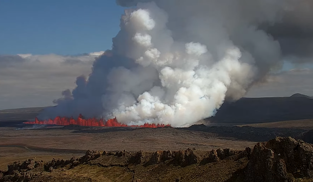
It’s erupting through the old cone now.
right where the fumeroling started a few hours ago
https://i.imgur.com/HfsTRzS.jpeg
That camera seems dangerously close, so I’m going to watch that! 🙂
Wow. Amazing views. Pressure must be high. It is now ripping open past the main cone towards south. Next few hours will be thrilling.
https://livefromiceland.is/webcams/fagradalsfjall
The rift is still getting wider. seems some camera’s are not wide enough 🙂