
Sulawesi is the unknown Indonesia. Some may remember it under its Portuguese name of Celebes. It is part of the northern chain of Indonesian islands which runs from Borneo to New Guinea. The island has a disjointed shape, appearing as a connection of peninsulas running in random directions, like an uncoordinated octopus. The four peninsulas have easy names: the East Peninsula, the South Peninsula, the South-east Peninsula, and (this one is harder to guess) the Minhasa Peninsula which is the northern one. Sulawesi is surrounded by an unusually large number of seas: the Banda sea to the south, the Makassar strait to the west (bordering Borneo), the Celebes sea to the north, and the Molucca sea to the east. In between the various peninsulas are (from south to north) the Bone Gulf, the Tolo Gulf, and the Gulf of Tomini. Sulawesian geography takes some memorization!

For climate, think tropical rain forest. For landscape, think mountains. Many of those mountains are over 2000 meters and the highest peak is over 3400 meters. Perhaps unusually for Indonesia (but in common with Borneo), the mountains are non-volcanic. The exception to this is a chain of volcanoes along the Minhasa Peninsula (remember: the one in the north), which include the recently active Mount Soputan and the highly dangerous Mount Awu. There is also a volcanic island in the Gulf of Tomini, called Una-una. And Sulawesi is home to a volcanic bird: the maleo (about half a meter long) which nests in sand heated by volcanic activity. It lets the heat do the work and incubate the eggs, and in fact denies any responsibility for raising its chick. But where the maleo can’t find volcanoes to outsource its work to, solar heating will do.
Most people live near the coast, where the lowlands are. The population of Sulawesi is expanding rapidly, and may now be as high as 20 million, double from the number in 2000. The lowland forest has been cleared, and this includes the mangroves. The rugged interior is much less accessible. Most people live in the south and this is where most tourists go. Palu, on the west coast, is the third largest city. It is a bit drier than most places, being in the rain shadow of the mountains, but don’t expect too much. The city lies at the end of a narrow bay, which continues in-land as a narrow, straight river valley. It is isolated by the rugged interior: access is mainly by air and sea. Before this year, the population was increasing at a rate of a few per cent per year.

Geology
Sulawesi has a complex geology – and that is an understatement. The western and southern parts are a continental fragment of Sunda Land, that once belonged to Asia and Gondwana. Around 45 million years ago, it split from Borneo when the Makassar Strait formed, a 2-km deep pull-apart basin.
The south-western part of Sulawesi came from collisions with continental fragments on the Australian plate. The two eastern and northern peninsulas formed as island arcs.
It gets worse. Sulawesi lies at a fragmented triple junction, where the Eurasian and Australian plates meet with the Philippine sea plate. Caught in the middle is a microplate: the Molucca sea which separates the Philippine and Australian plates. It is not doing well: it has subduction zones on both sides, only a few hundred kilometers apart.
There is also a subduction zone north of Sulawesi where the Celebes sea goes down into the abyss. This is the cause of the northern volcanic arc. The western end is subducting faster than the eastern end, causing a bit of plate rotation.
Finally, the Gulf of Tomini appears to be an extension basin, adding further complexity. It is not fully clear what is causing it, but the fact that it runs parallel to the Celebes subduction zone suggests it may be caused by the continental crust catching on the subducting oceanic crust in a process called ‘roll back’.
Faults
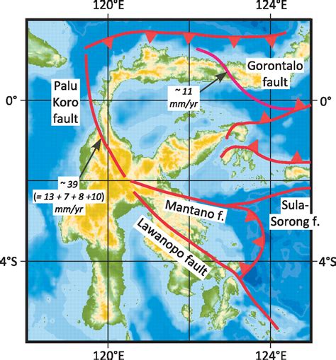
The geological evidence leaves us with an image of a tortured history. The events have created scars: the region is riddled with faults. To the north is the major subduction fault, the North Sulawesi Trench. The northern peninsula is crossed by the Gorontalo fault, and bordered on the east by the double subduction fault of the Molucca sea. On the western side of Sulawesi runs the Palu-Koro fault. It begins where the subduction fault ends, runs south along the thin neck region of Sulawesi, turns south-east towards Palu and continues to cut across the central regions. Further south, it connects to the Matano fault which runs into the eastern seas where it becomes the East Sulawesi Trench, obviously another subduction zone bordered by the Australian Plate. Another fault continues from the Palu-Koro/Matano intersection, running southeast: this is the Lawanopo fault, which runs past the termination point of the East Sulawesi Trench; this fault shows little activity. There are further, more minor faults but this is enough for now.

from http://alain.lave.be/Indonesie_2009/Lokon/Geodynamique.htm
The next challenge is to imagine how each part of Sulawesi moves. The southwestern part, bordered to the north by the Palu-Koro and Lawanopo faults, move northwest at about 1-2 cm per year, while rotating clockwise by 1 degree per million years. The part north of the Lawanopo fault, comprising the eastern and northern peninsulas and the neck, moves north-northwest at some 4-5cm per year while rotating anti-clockwise at 4 degrees per million years. At the far side of the East Sulawesi Trench, the Australian plate is moving north at 6cm per year, and on east side of the Moluccan double subduction region, the Philippine plate is racing west-northwest at 9cm per year. You can imagine the stress regime.
And this stress lies at the heart of the events in Palu. The conflicting movements of the southwestern and northeastern blocks were what generated the destructive earthquake.
Major earthquakes are a frequent occurence in Sulawesi. They occur mainly along the northern and northwestern coast, along the North Sulawesi Trench and the sub-sea section of the Palu-Koro Fault. Along the north coast, there have been 4 M7+ quakes since 1990 (two of which formed a double), while in the northwest where the 2018 quake occurred, there have also been four quakes of this size since 1968. A M7.9 on Jan 1, 1996, a little north of the 2018 quake, was the largest event during this time. The 2018 quake was the most southerly of this series.
The Palu-Koro Fault

The Palu-Koro Fault is the San Andreas fault of Sulawesi, splitting the country in two. After it turns in-land, it runs from the Makkasar Strait towards the Gulf of Bono, although it peters out before quite getting there. The fault line is easily distinguished in maps, running straight as a ruler. North of Palu, it has formed a wide bay which at Palu becomes a wide valley, and 25 km south of Palu the valley narrows to a deep scar. Along Palu Bay, the main fault runs along the western side. It is a ‘left lateral slip-strike fault’: look across the fault, and you will see the other side move left. But there is also extension going on, caused by the opposite rotation of the two sides which makes the two side pull a apart. The movement along the fault is some 3.9 cm per year, and the bay shows extension at a rate of just over 1 cm per year.
Once the valley narrows, the location seems to shift slightly. It now continues along the line of the eastern side of the bay and valley, rather than the western side. Images of the narrow valley make it appear remarkably like parts of the San Andreas fault, although it appears much deeper incised. Earthquake activity in this part has been minor, but it is not known whether that is because of a lack of long-term monitoring. But there has been activity along the wider valley, including an M6.3 event about 20 km south of Palu in 2003.
The valley is bordered by steep cliffs, especially on the west side. This already indicates that the fault is very active. If events are infrequent, erosion has time to wear down the slopes and make them shallower. There is indeed geological evidence for three earthquakes of size M7-8 in the past 2000 years, or one such earthquake every 700 years. This may not be complete: in tropical climates, erosion can remove traces rather quickly and the dense vegetation also doesn’t help. Together, the three events involved movement of around 30 meters. This is clearly not enough: over that time the fault should have moved twice as much. A paper in 2017 by Watkinson and Hall pointed out the discrepancy. Either much of the movement happened smoothly, or events were missing from the data and the earthquake risk here had been underestimated.
The maximum size of an earthquake is set by the length of fault that can rupture in one event. This can be limited by step-overs, where a fault moves across by a few kilometers and continues there. It had been argued that such steps were present in the Palu-Koro fault on-land, with one paper claiming four parallel faults. If so, earthquakes here should be limited to M6-size events. But if the on-land segment was a single, continuous fault, this was optimistic. In that case, Watkinson & Hall found that it was capable of generating a M7.6 earthquake. In hindsight, they were remarkably close with this value.

The Palu valley. Source: http://travels.davidmlawrence.com/Indonesia/Sulawesi/Palu.html
The 28 September 2018 Palu earthquake
The 2018 event started with a M6.1 foreshock, close to the top-end of Palu Bay. It struck just north of Donggala and lasted 10 seconds. (There have been reports that there had been earthquake activity along the southern part of the fault for some months before the event but this is uncorroborated.) Three hours later, at 6:02pm local time, came the main shock, an M7.5 which began a bit further north. It ruptured the Palu-Koro fault over a length of 100 to 150 km, terminating some distance to the south of Palu. The city of Palu, which had been build on top of this fault, was hit by three disasters in quick succession.
Moving the earth
The first disaster was the earthquake itself. How strong this event was can be seen from the amount of slippage. The map below was published on twitter: it used before-and-after satellite images to measure pixel offsets. In the city, the movement across the fault was 6-8 meters. (A gif of two sentinel images shows the shift of part of the city: you can see it here but be aware that the speed is set to a rate which seems in the epileptic danger range. After a while you’ll recognize the straight line running through the city, just right of the centre.)

Further south the movement was less but it appears that much of the broad valley south of Palu still showed rupturing. However, the end point of the rupture is not well defined. And we don’t know what the displacement was to the north where the fault runs under water! As an aside, the line of movement through the city shows exactly where the fault reaches the surface. It is indeed along the western side of the valley.
In hindsight, the research done the year before which found that the known earthquakes were insufficient to accommodate the known slippage of the fault could have been a warning sign. Rather than a sign of a-seismic slip, it may have been the first evidence that this fault was primed to fail.
Liquefaction
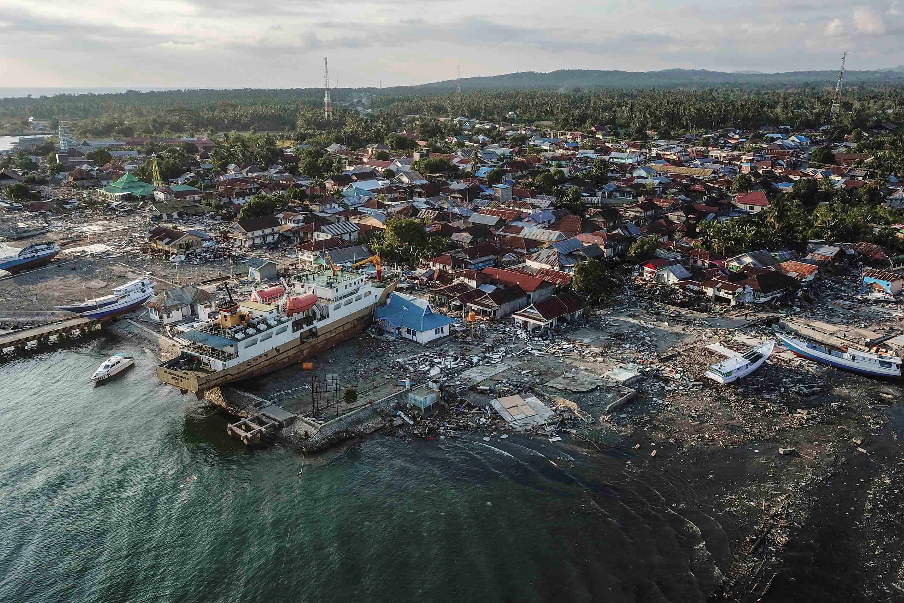
The second, and worst, disaster came in tandem with the earthquake. In parts of the city, the soil turned to liquid. This effect has been seen in a few other earthquakes, most notably in Mexico City, but in Palu it was particularly destructive. Liquefaction can occur in wet sediment, and is a problem for instance in areas where the soil has been raised through infill to bring it above water level. Palu was at particular risk of this: the soil hit all the danger buttons, being water logged and low lying. The fact that the event happened close to the end of the rainy season may have contributed.

Liquefaction can be induced by earthquakes when the shaking moves water around. The soil suddenly looses its strength, and becomes liquid. In Palu, this happened in areas with shallow slopes. The liquid mud found itself unable to hold on, and began to flow down the slope. This can happen on slopes as shallow as 1-2 degrees. Videos indeed show buildings moving sideways. Whole streets were swept away. This was probably the most damaging part of the Palu earthquake, and the cause of the majority of casualties.
Tsunami
The third disaster came shortly after, and this has received the most attention. A tsunami warning went out shortly after the earthquake. The early prediction was for a quake of 2-2.5 meters. The quake happened shortly before high tide, and this did not help. The tsunami duly arrived. According to some reports, a total of three waves hit Palu. There is some confusion about the timings, but it appears that the first one came at 6:10pm, within ten minutes of the quake, the second 8 minutes later and the last one arrived a little after 6:30pm. The highest waves were some 6 meters tall, twice the height that had been predicted.
Donggala after the tsunami
There has been much discussion about the tsunamis, focussing on the missing warning systems and the unexpectedly high waves. On the first part, the answers are becoming apparent. A tsunami warning was send out. It was withdrawn after some 30 minutes, with some dispute whether the final wave hit before or after that precise time. (One report claims that the warning was withdrawn after 5 minutes.) The warning was probably withdrawn too early. It was based on the expected travel time from the location of the earthquake, but perhaps did not take account of the waves washing back and forth in the bay. In the end, there were no more events afterwards, so even though it would have been wiser to wait longer, this aspect did not add to the casualties.
A system of buoys which measure tsunami wave in the open sea was installed after 2004. It is not clear that any of these were in the right place for the Palu event, as the waves only showed inside the bay and probably originated there. But this was a moot point as apparently none of these buoys remain operational. Hardware was stolen and maintenance was not taking place – the first is not unexpected in a region where entire ship wrecks are stolen for their iron content, and the second shows that to build something is cheap but to maintain expensive, which is the wrong way around for government funding. Finally, the system to warn locals about the impending tsunami relied on mobile phones and loudspeakers. Both were out of operation after the earthquake when mobile transmitters collapses and electricity went off. But even if the warning had been received, it is not clear that people would have taken heed.
But why was the tsunami so high? This remains an unsolved problem. Tsunamis form when part of the sea is displaced, because of the sea floor going up or down, or a landslide falling into the water. In a slip-strike event, the sea floor moves horizontally. It is harder to create a tsunami in this way, and although there have been tsunamis generated by past slip-strike events, they were mostly small or caused by landsldes. There was no tsunami outside of the bay, and it appears it formed within or very close to it.

The first possibility is that it was caused by a land slide. The image shows the bathymetry of the ocean near Palu. There are indications for extensive land slides which have taken place in the past. Such past sub-sea landslide may have become destabilized, or a new event may have occured. This has a high degree of plausibility, and would explain why Donggala, at the entrance to the bay, also had a large tsunami.
The second possibility is that the slip-slide in the bay took place on a steep slope. In that case, the 6-8 meter movement (or more!) could have pushed the rock face out, and this does displace water. There is indeed a steep gradient inside the bay, from 10 meters near the head to 170 meters further out, to 1000 meters outside of the bay. This remains speculative though. However the fact that over the past century there have been three tsunamis associated with earthquakes on the Palu-Kolo fault (1927, 1968 and 1996) shows that this slip-slide fault is capable of this, somehow.
The third possibility is that the shape of the bay amplified the wave much more than expected. Palu Bay is a fairly narrow inlet and runs from deep to shallow. Tsunamis grow taller as the sea become shallower and the wave slows down. In water of 200 meter deep, the tsunami travels at 160 km/h, while in 10 meters deep water, it goes at 35 km/hr. Models for Palu Bay find that the wave would increase in height by a factor of three while traveling into the bay. That predicts a maximum height of 5 meters which gets close to the actual events, but this models is for higher waves outside of the bay which were not seen.
An interesting point is that at a depth of 200 meter, the tsunami speed would travel along the bay in 5 minutes, with a wavelength of about 40 km. The waves came some 10 minutes apart. This could be a resonance of a standing wave, given the length of the bay of 20 km. A standing wave would have impacted mainly both ends of the bay, where indeed Palu and Donggala are located.
The jury remains out.
Final point
The Palu 2018 earthquake will be studied for years to come. It shows how dangerous it is to build a city directly on a major fault (Wellington, take note), and how important it is for detailed studies of past behaviour of a fault, not over decades but millennia. It shows the need for a working tsunami alert system, with training to make people aware of the system. We need to understand tsunamis better, with detailed models of coasts and the local bathymetry. But perhaps most important is the danger of liquefaction. This, more than anything else, is what turned this disaster into a catastrophe. Some localities are not safe for building on. When all the relief work has come and people are ready to rebuild their lives, perhaps they should be encouraged to do so away from the danger zones. We can’t change the past — but we can still change the future.
Albert, October 2018

A stone-age megalith of Sulawesi


Nothing to really back this up, but I think one side of that elongated bathtub went one direction while the other side went the opposite, relative to each other. It makes for a bad future for Izmit Turkey if the nearby Gulf of İzmit off of the Sea of Marmara does something similar when the Anatolian Fault finally gives way in that area.
Just an opinion, but that city is as good as done.
Caveat: I am some random dip$@#$ in Florida on the Internet, not an expert. (In other words, if you are a journalist or reporter and base an alarmist article on what I have said, you are a fool.)
Tsunamis are known in the sea of Marmara, but not a large as what happened in Palu. There was one in 1999. But in Turkey the earthquakes themselves tend to be more dangerous.
That tells me that Marmara is prone to generate tsunami at the slightest tickle. All the more reason to worry about the typically large Anatolian Fault events.
and they tend to build pro earthquake buildings too….
Absolutely fascinating, thank you Albert.
Thanks Albert. Very good read for a Saturday evening.
So what about the very southern end of the San Andreas where it emerges into the Gulf of California: could it be tsunamagenic there? Ditto in northern California where it goes offshore towards the Mendocino trip junction. After all this event has shown that strike-slip faults can do it in the right circumstances.
South of the Salton Sea, the North American Plate to Pacific plate boundary turns into a series of transform faults and spreading centers.
Tsunami is not out of the question, but the long throw strike-slip dynamics are not there.
Coming soon, to a coal seam near you!

Technically, monocots didn’t appear until the end of the Cretaceous, so the image is a bit misleading.
Carboniferous park would arguably be scarier than Jurassic park. Dinosaurs were tetrapods like us and so punching or stabbing them in the head area would cause an involuntary reflex to go into defence mode which would allow escape (at least in theory). Arthropods do not have such reflexes.
If you have ever seen centipedes eat things it is quite literally the stuff of nightmares, their venom contains seratonin which among other things basically overloads pain receptors to incapacitate things (it is apparently far worse than anything on the insect sting index, watch brave wilderness), and they only eat prey that is either still alive or killed by the animal itself in the process of being eaten. They are also armoured to the point that few animals in their size range can actually do anything to them… Arthropleura wasn’t a strict carnivore but it shows that centipedes could have gotten big enough to eat things in our size range…
The other interesting thing is that high oxygen wasn’t the reason wgy arthropods became dominant either, the biggest arthropod that ever existed lived during the silurian when the atmosphere was barely breathable, and the biggest flying arthropods existed during the middle permian and late triassic, when oxygen was barely high enough to support combustion. Also look at dobson flies, which still exist now, wingspan of up to 22 cm.
At least there are no giant wasps, asian hornets are big enough at 5 cm long, a hawk or eagle sized wasp would be like a weapon of war…
So… wad cutters and hollowpoints at a minimum. FMJ will not do the trick. (Ball ammunition)
Ball is the only accepted ammo for War. Using any of the other ones opens you up for War Crimes prosecution. (maiming ammo)
And yes, there are international Rules for War.
“An unlawful combatant, illegal combatant or unprivileged combatant/belligerent is a person who directly engages in armed conflict in violation of the laws of war.
…after a “competent tribunal” has determined that they are not eligible for POW status (e.g., Third Geneva Convention, Article 5.) At that point, an unlawful combatant may be interrogated, tried, imprisoned, and even executed for their violation of the laws of war pursuant to the domestic law of their captor”
Yeah, I think ill stick with the bunnies and donkies at our local petting zoo, thank you.
An Eagle sized Asian Hornet woud be the ultimate weapon of war
Bioweapons, hard to kill flys fast and hard to point at… shooting it… woud not kill it Insects fly and crawl despite damage. Diffrent from mammals
Im so happy souch monsters dont exist.
Until some North Korean lab… finds a way to breed giant warrior wasps
Daily Mail features a satellite video representation of the soil liquefaction event. I have an animated Gif capture of it, but due to copyright issues I can not post it here. However, a few observations for those of you who go look at their video. On the right side of the image is what appears to be a wide two lane road. It is not. It is a dirt road down either side of a waterway/creek. What is interesting, is that it acts as a de facto head-wall for the failed terrain. Everything down-slope of it gets caught up in the slide. At a bridge crossing this creek, to the river that runs through town (near the bottom of the slope and outside the video on the left) the grade is about 3.5%. Not something you would usually think of as dangerous. Now, whether the creek maintained a high moisture content in the soil down-slope, is a point for conjecture. From the way I understand soil dynamics and hydrology, yes it would maintain a fairly high water table. (Not a geologist, I just spent way too many hours in the library as a youth)
NOTE: If any of you are versed in hydrology, your input is more than welcome!
Is the creek the cause? Well, it was probably going to be there anyway. I was fairly sure that no one specifically came in and put it there. BUT, I have no idea about the history of this creek or if it was put there for irrigation many years ago. It does parallel the natural drainage of the valley. In fact, 177 meters north of the bridge, the creek joins a stone paved drainage channel (also destroyed) that then heads down-slope along the roadways and later joins another rivulet draining from north of the airfield runway.
A pre-slide view down-slope on the road from that bridge. This is one of the roads that grows longer and is then destroyed, along with all the houses.
And a view of the waterway looking south from the bridge on the road near the track. The far end of this waterway moves to the left by about it’s own width by the end of the slide in the video. Everything to the right of the creek gets moved around, except for the road and a few of the trees.
And for those poking around in Google Earth, the position of the track in the video:
-0.936101° 119.923031°
(0.936101S° 119.923031E°)
Carboniferous era was indeed scary
Enormous wilfires and giant spiders and arthropods
Carboniferous primitve spiders coud grow large enough to hunt cats and kids IF they was alive today
Yuck. Carboniferous was warm and humid in the first phase, but the forest sucked alot of co2 from the atmosphere as the era went on.. oxygen levels soared to 35% and Co2 dropped
The In Late carboniferous the Supercontinent was mosty around equator thats increased rainfall and weathering, and co2 dropped even more. This caused the Karoo Ice Age that was quite severe,
As the perminan came increased volcanic activity, raised co2 and world came bacjk into hothouse
The giant spiders didn’t exist, Megarachne was a eurypterid, a terrestrial member of the ‘sea scorpions’. It was probably not actually particularly dangerous, maybe like a coconut crab. That actually brings up a good point, coconut crabs are bigger than 90% of Carboniferous giant arthropods…
Carboniferous was when arthropods were most dominant of the land, but this was way less to do with oxygen and a lot more due to tetrapods being ‘amphibians’ which were still largely semi aquatic (amphibian in the lifestyle, they were not the same as the modern Lissamphibia) preventing extensive terrestrial colonisation until the latter part of the period.
The biggest flying insect ever was Meganeuropsis, which was related to the well known Meganeura but about 20% bigger and lived at least 10 million years after the end of the Carboniferous green period. Still it was only twice the size of the modern biggest flying insect. Also look at the Titanoptera, Triassic insects related to grasshoppers but which looked more like praying mantises on steroids and which were probably one of the main reasons pterosaurs evolved, modern predatory katydids and mantises eat their prey alive and so quite a way to go, being eaten alive probably starting at a very sensitive part of the body or through the head and with no pain killers…
And also lets not forget modern big arthropods – coconut crabs, titan beetles, giant water bugs, lobsters, etc. giant water bugs are known to eat things as big as vipers and resting water birds, definitely not at the bottom of the food chain…
At least there aren’t any truly giant centipedes around now, the 30 cm ones are scary enough and can potentially kill you already so one that is 10 times bigger would be…
Holy shit! 😬
https://m.youtube.com/watch?v=nWZMfPP34g8
don’t mean to be sexist but why don’t we see women doing these things?? ((i know why>>>>))
Take it as a compliment
“why don’t we see women doing these things?”
For the same reason that on average, women have longer life-spans.
Carboniferous had superlow co2 at one stage just like early holocene
Scary when the volcanic activity Co2 is low and weathering high
Always Snowball Event looms 😬
Luckly last ice age was just glacial
I Hopes that does not happen again
Not today with high human Co2 output
Humans release huge ammount of Co2
Similar to a fairly large flood basalt event
Snowball event won’t happen on earth now, you need a supercontinent that is at the equator, or at least all land near the equator so there is no land anywhere near the poles, and you need low CO2, and most importantly you need the earth to be under weak sun. The sun was only half as bright as it is now when it formed, and was still only about 85% of its current brightness when the first snowball earth events happened. The cryogenian period was about 800 million years ago, the sun would have been about 93% of its current luminosity which combined with the other factors was enough to give a final snowball, but that wouldn’t be enough now.
No, this is too optimistic. The sun was 70% of its current brightness at the start of earth, not 50%. The last snowball earth event was less than a billion years ago and the sun was not that far off its current brightness. It is entirely possible that with current conditions, it could still happen. But snowballs were rare events. We don’t know how many ice ages (as we are in at the moment) developed into one.
But, The Deadly Mantis!!!! 😳
Sulawesi likley looks like the first archean contients, before any large cratons formed.
Early Archean likley had lots of continents around subduction zones that resembled Sulawesi.
That area of Earth Above Australia is hot and active and twisted
I note that Albert forgot the worlds most active supervolcano in this article.
Soputan is together with Lokon-Empung and 3 other strato-cones ring-fault vents of the Tondano behemoth.
As I once wrote, the other supervolcanoes would do well by hiring a PR-agency, since they are always forgotten next to their lazy arse American brother Yellowstone.
Loved the article Albert, it put the blame squarely where it should be, with the liquefaction.
I did consider but felt the post should not be about the volcanoes- the coincidence of the eruption at the north peninsula has already caused enough dubious reports linking the two. In terms of danger, I rate Awu very high.
I agree, Awu is currently a more dangerous volcano.
Soputan and Lokon-Empung are well known dangers only likely to cause fatalities if someone is on top of them if they go off.
Tondano is extremely well behaved for being such a massive volcano. Only large risk would be a center caldera maar formation at one of the active hydrothermal fields. From a geologic standpoint they are rather common.
I also read comments that this earthquake could have caused the eruption at Soputan.
I am highly dubious. Soputan and Lokon-Empung are pretty much leaking all the time, quite often at the same time.
So, at best it might have started the new eruption a day or two earlier than it would have without the earthquake.
We know from other major caldera volcanoes that they instead tend to work as seismic wave dampeners, and under Tondano you have several thousands of cubic kilometers of mush eating away at the energy, and volume is so large that any energy increase would be minute indeed.
Is that mush eruptable then?
I wants a superplinian
Give me 4400km3 of Ryhodacite ash in a few days or hours
It is eruptable…. And it is erupting!! because it’s constantly leaking out of Soputan, Lokon-Empung, and, if things get pressurized, Mahawu.
As Carl pointed out in his previous Tondano article, the chamber stays well vented by it’s ringfault daughter volcanoes. As long as that stays in play, it will never happen.
Soputan looks pretty .. lava flow and fountains good nightshots
NO cgi needed… the photos can be put in an action film
A photo from the japanese asteroid mission. The shadow on the asteroid that looks like the Hubble is of the course the japanese orbiter that took the image
And this is the area from a distance of 64 meters. Tiny pebbles can be seen
Is this the rendezvous that put a lander on the roid? From what I understand, it moves around by hopping. A literal robotic space cricket.
(Not enough gravity to get traction with wheels)
Yes, these images are from the orbiter as it descended to release the hopping robots. There are also images from those but the orbiter has a better camera, I think.
Now I wonder how they keep from tumbling while in flight. Landing crooked would be a show stopper.
That asteorid is a rubble pile
Rocks and gravel Held togther by gravity
It never got hot and large enough to melt and diffrentiate. The gravity of that object is almost zero
IIRC, BBC TV News had an unsettling clip of a mostly-intact rice field which slid almost a kilometre…
As for the rest, ‘Oh, the Humanity !’
…so, you plant a field, it slides onto someone elses property… who gets the rice?
The lawyer
Liquefaction is OVERLOOKED here in the SF Bay Area. But…the Millenium tower IS sinking, and the brand new TransBay transit terminal is closed 3 weeks after opening for cracked support beams. They’re blaming it on improper annealing….that may be part of it, but again it’s all backfill down there. I’m waiting for the shiny new Salesforce tower to start having issues. I think they might be just far enough inland, though. Any decent sized quake will cause chaos in SF with liquefaction more than shaking. There was also intense liquefaction in Japan, 2011. Lots of YouTube vids of it.
In 1850, the area of that tower was a cove on San Francisco Bay.
There will be No lava for me 16 december
But I will get to meet John 🙂
Hawaii – Kilauea and Mauna Loa 16 december for me
is that John Stalman?? Tell him i thought he was very patient and charitable and still willing to try and communicate the true hazards to keep people informed and safe. Best!motsfo
John Tarson : )
Well considering that some of kilaueas eruptions have occurred within an hour of the first quakes (hekla isn’t the only volcano with that ability) and that there is both a big deep hole at the top and inflating area on the rift, you could very well see lava. If it’s at the flank you probably won’t see it unless it flows over the highway or you catch a boat, if it’s at the summit you probably won’t want to actually be able to see it… 😉
BTW, the majority of damage (in San Francisco) from the 1989 Loma Prieta quake was due to liquefaction and associated structural failures in the Marina District…..not unlike what happened in 1906. But that was right on the waterfront. Down in Sunnyvale where I worked in a large semiconductor manufacturing fab, our brand new $16M R/D building suffered major damage from the interior stair well collapsing. Eventually, the building was abandoned then sold before being largely rebuilt from the ground up as a low-cost office building. Despite the facility was originally built to the highest codes, it was later discovered that the groundwater table was highly variable at that location, and was prone to amplified shaking and ground settling/deformation. At the the time the building was constructed in 1986, the water table was “thought” to be lower by over 20′ than what was later found in 1989 ( when the quake caused the whole kit and caboodle) to sink into the ground (i.e. leaning tower of Piza).
Holy crap. No kidding!? I was an 8 year old kid in 89 when that went down. The first time I drove across the old western span (and across the collapsed segment) into SF, I nearly cried. I’m still not fond of the Bay Area bridges knowing the seismic potential. I’m glad that bridge was closed down not long after. Bad memories.
That’s a good counter-point.
“But if Neanderthals could make fire, why would you see fewer fires during glacial periods, which Prof Sandgathe says implies they could not make fire and instead were reliant on wildfires?
Last year in the journal Quaternary International, Sorensen argued that though it might seem counterintuitive, if a species can create fire, it would leave fewer traces of fire in the fossil record, not more, because it would not have to keep fires going continually and could economise fuel by using it sparingly when needed. As there would be fewer trees growing during an ice age, hominins would want to be prudent about when they used them for fuel.”
https://www.bbcearth.com/blog/?article=did-neanderthals-learn-to-make-fire-before-homo-sapiens
https://www.bbc.co.uk/news/science-environment-45775309
In my opinion, this is extremely difficult considering current state of human denial, laziness and obsession with anti-environmentalist politicians.
I don’t want to feel powerless either. I rather prepare myself for the gradual “collapse” of civilisation looming the new few decades. And that no one seems to talk about. What to do, where to relocate, and how to foresee how society might become.
I say “collapse” because obviously civilisation still lives in places like Middle East, Africa, Latin America, southeast Asia. It’s just going to be a collapse of the current sociopolitical structure.
Want a fun activity? Go to your local grocer and tally up how many calories per meter or foot of shelf space there is. Then get a value for the population density and work out how long that location could supply the caloric intake of the local population if the restocking system was completely shut down.
My estimate usually comes in at about 4 days until the population reverts to hunter gatherer.
Four days after Brexit in our (UK) case
Mmmm I love the taste of Project Fear!! 😛 😀
You could take this a step further if you want to get really hairy with the model. How many obtainable calories can the local countryside provide in that situation? If you are writing a novel, now figure in how the crop or farm owners are going to respond to that. Hint, it’s gets dire fast.
Note, you can’t call it “civilization” if no one is civil.
i expect the local bullies to raid my pantry before too long. i have a large stock of food because i live in a place that gets cut off fast.. bad weather, avalanches, wind storms, earthquakes.. and supple ships from the lower 48 experience strikes… think soap and toiletpaper….. and i don’t want to survive if there’s no toilet paper…. most of the trees around here are spruce 😉 i’m in my 70’s…. more than ready to hang it up. Best!motsfo
Get a large angry dog.
At least that way you get a floor-show. Even better if you have a Brahma Bull hanging out in the field around the house. Then you can watch the races.
If canning is your thing, and you are the vindictive type… keep those secret jars of tasty jam lased with ipecac stashed in the pantry. Just make sure that authorized pantry uses know which jars to not use.
Family Lore; Had an aunt who told the story of one of her nurses getting fed up with other people pilfering her stuff from the community fridge. She used a double boiler and melted down Ex-Lax and formed it into chocolate treats, put it into a bag marked as the possession of someone else and left it in the fridge.
The results were as expected.
http://strangesounds.org/wp-content/uploads/2018/05/science-5.pdf
Being currently in the very rare situation where kilauea actually isn’t doing anything new at all, I found this info on the 1959-1960 eruptive episode. There are a lot of very notable things especially about 1959.
The last 3 episodes of the kilauea iki eruption actually had more in common with a plinian eruption than a typical hawaiian eruption, the fountain consisted of individual lava particles instead of a mostly liquid part that is easily distinguished from the rest of the tephra column. This is unique in historical time for kilauea, mauna ulu and pu’u o’o were very tall but more conventional lava fountains, like a bigger version of the fountains during this years eruption. The eruption rate of 1959 was also the highest of any eruption in Hawaii, about twice the rate of this years eruption and equivalent to mauna loas 1950 eruption but all through one vent. The main vent also formed at the point where the 1959 fissure crossed over a ring fault that at later points erupted in the 1970s and this combined with the connection to the east rift, great depth of the magma source and necessity of the conduit being very deep to sustain such a powerful fountain means that it is likely it was more of a ring fault eruption that was partly connected to halemaumau. As such kilauea iki is very likely not inactive despite the deep caldera, a big eruption can and probably will reoccur there again.
The other part is how big the 1960 eruption actually was. Unlike most eruptions on kilauea it basically went big right from the start, even on day one the fountains were exceeding 100 meters, and the ending phases featured a lot of phreatomagmatic activity that is apparently not recorded in any of the several films of the event. There was also much more minor activity that was downrift if the main vent – a small eruption near the former school, a small vent near the lighthouse and even a possible submarine vent. It is an interesting read.
Leilani was a quite huge eruption, over 1km3
The reason we did not get Giant Lava Fountains this time ( over 400 to over 500 m ) is that Puu Oo and Halemaumau had degassed the system the years of activity before.
Halemaumau and Puu Oo acted as gas vents.. thats why Puna did not have giant fountains this time I guess.
Halemaumau was like a huge gas valve fluid magmas relased more sulfur than all of US carbon plants combined. Im soure ina few years when Halemaumau have charged up again, we will get giant lava fountains
I found the volume of the eruption to be about 1.2 km3, 0.16 km3 from the initial flare up (May 18-28) and then slightly over 1 km3 for fissure 8. A large portion of the lava from fissure 8 is below sea level off kapoho and ahalanui. This amounts to an eruption that was about almost 50% bigger than holuhraun when you compare the time durations. Only tolbachik 1975 and holuhraun have been bigger volumes since 1783, but both of those lasted way longer than 3 months. I don’t know what this really means in the long term now, but it shows that kilauea is more than able to hold its own against both Iceland and against its neighbor. If an eruption this big also wasn’t able to collapse the east rift conduit then it might take something even bigger to finish the job too…
This years eruption formed reticulite in abundance, a rock only formed by gas rich lava, and had an SO2 output of over 50,000 t/day for much of the eruption, the amount of degassing seems like it was really pretty negligible. The reason for the lack of high fountains is that the degassing point was nearer to the surface for this eruption than it was for pu’u o’o, so not enough momentum could built up to get the fountain to 400 meters. Pu’u o’o, mauna ulu and 1959 were all fed from a source that was about 4 km deep at the point of degassing, about 3 km below sea level. 1960 had a deeper source, about maybe 1 km deeper, and this is also supported by its more olivine rich lava. This years event came from pu’u o’o and had to start at about -4 km and move up so the dime was probably only about 1 km deep below the lowest vents at fissure 18. Below fissure 8 it would have only been a little bit deeper.
1955, 1977 and fissure 17 did actually make some pretty high fountains (150 meters for fissure 17, 300 meters for 1977 and 1955) but those were more evolved magma which exhibited a more strombolian character and is less comparable to fissure 8.
There is also the erosion of the vent causing the opening to be too wide to form a jet of lava. 1959, 1969 and 1983-1986 were all very episodic with long periods between fountains, so the actual time spent in the act was not very much of that time, the 4 weeks of continuous high fountains in 1960 was probably the longest sustained high fountain of any observed eruption of primitive basalt anywhere. Erosion of the vent is well observed for holuhraun, and it also probably occurred for mauna loa in almost all of its eruptions, kilauea 1840 and 1790, skaftar fires and eldgja.
The best place for high fountaining on kilauea now is probably the south caldera faults, near keanakako’i. That magma source is about 4 km deep and could be connected to the all of the previous high fountaining eruptions so the area has real potential. Eruptions within halemaumau are likely to be relatively smaller as there is less distance to allow acceleration to a great height, unless very gas rich new magma erupts directly or water interaction.
It will be fun when Katla well erupts
Daily Fail, Faily Star, Faily Express… they will go absoultey nuts writing doomsday crap.. when it well erupt.
It will be hilarously fun.. their reactions.
Katla is the biggest fake news factory on the planet after yellowstone
did anyone catch this?? study out that it wasn’t liquefication… isn’t quick clay liquefication?? https://www.tonkintaylor.co.nz/news/2018/10/liquefaction-experts-provide-alternative-explanation-for-indonesian-landslides/
Best!motsfo
Yes…. it is. So, where do they propose the glacier was at to make the marine clay?
(A better source would be altered rock, made from normal weathering) but liquefaction is liquefaction.
To me, it doesn’t appear to look like this.
Hey Lurk, are you picking up on Michael yet? Looks like he might be headed your way….maybe CAT 2 off the coast before weakening as it hits shore. Historically, as a cyclone decays, it’s wind and rain fields expand. Hope nothing like what happened up in the Carolina’s (flooding) will result.
Forgot to add that as the rain and wind fields expand, they also become less intense (on a local level)…… just more widespread.
I’m gonna be on the western side of the storm (the weak side), there is even a possibility (slim) that I won’t even get tropical storm force winds.
What has me puzzled is that Bellview Florida has been under a high surf advisory since yesterday. Bellview is a neighborhood that isn’t even on the water. It is possible though, that they are talking about the backwater of Perdido Bay which runs up next to Saufley Field. Apalachicola bay might be problematic, it has a very gentle continental shelf that serves to amplify any storm surge run-up.
People that should be worried are Panama City FL and Port St Joe. But, aside from the populations centers there, most of the region is made up of thousands of acres of Flatwood and pine forests.
This is also the region of Florida’s Volcano, so that could get interesting. (Spoiler Alert; it’s not a real volcano, just a legend)
The Spooky bit (which is NOT going to happen according to the model runs, 18% say Cat-3 at landfall, 82% of them say Cat-2 or lower) is that this it roughly the track that Camille took in 1969. Camille hit the slot and went due north, becoming Cat-5 by the time it got to the Mississippi Gulf Coast. In part, this was due to it driving directly over top of a warm eddy current in the Gulf of Mexico all the way to the coast. Favorable winds provided a shear free environment at the time.
Michael doesn’t get that. Plus, there is a front dropping in from Texas that will provided added motivation to get across the Gulf quickly. However, the Gulf is currently just a pot of hot water (as normal) with overall temps above 29°C.
Oh lookie… the Superlative News Network just woke up.
Since they are madly flailing their arms about this, I went an looked at the surge projection. We may get as much as 2.4″ of surge here.
Sopchoppy might even get surge that far inland.
Okay… It’s Florida. Sopchoppy; “The town is home to the annual Worm Grunting Festival, a town celebration named in honor of worm grunting” → “a method for driving worms to the surface”
(Evidently this technique made it into the plot of Tremors.)
https://cera.coastalrisk.live/
We are supposed to get squalls and about 4 inches or more rain as Mike blows by just south of Tampa. My son came home early today. He does stucco work and they were pulling down scaffolding this morning. Tomorrow they will get it secured so it don’t blow around. I guess we will see how big the storm field gets after it passes Cuba. Maybe it will spin enough heat off so things will start cooling down.
Hope yer right. The latest HWRF (Hi-Res) forecast is showing a 942mb core with 107kt winds (solid CAT 3) at landfall…with the most prominent rain field(s) curiously to the N and NW despite a general NNE track of the core once it hits land. As you say, the relatively fast storm motion may help mitigate any major flooding risk(s) other than the typical urban and small stream stuff. Fingers crossed for you guys.
p.s. send of this to California, will you?
edit: “some of this rain”. LoL.
You can have it all if you can figure out how to steer it there.
I was poking around on the Internet and saw that one region of Kansas was getting it’s rainfall deficit taken care of… in a single storm.
A geological note for anyone interested. The area from Panama City Northwest through Defuniak Springs, is karst topology. That’s gonna be interesting to watch after all this water gets dropped there. Hwy 79 North as far as State Road 20 tracks right up this region. Sinkhole lakes all over the place. The center of Defuniak Springs is one such lake. The topology is due to the Port St Joe fault fracturing the bedrock in the area. (It’s a ancient and generally quiet old transform fault left over from the opening of the Gulf of Mexico) By my reckoning, it runs all the way up into Alabama. It’s a parallel sister fault for the one under Dauphin Island at Mobile Alabama.
I saw it somewhere here, but can’t relocate it. So, here it is again for those of you who may have missed it.
https://www.manchester.ac.uk/discover/news/astronomers-confirm-collision-of-white-dwarf-and-brown-dwarf-stars/
“We think that the brown dwarf will have disintegrated. Some of it burned up in the thermonuclear explosions that were triggered on the white dwarf, and some of it was thrown out. The jets formed probably from a rotating disk around the white dwarf, containing the remnants of the shredded brown dwarf.”
The mechanics of how jets form has always been beyond me. They are seen in a lot of astronomical objects. I don’t know if it has to do with angular momentum from the accretion disk, or something to do with magnetic flux. It’s just flipping weird.
Could the tsunami have been caused by liquefaction of the sea bed in the bay?
Not out of the question, but more likely a land slide than liquefaction. I still hold that the two sides of that bay shifted positions relative to each other and caused a seiche.
I think some form of sieche wave is where I ended up in my ponderings. If you factor in the tide, that may have acted as the stopper in the bottle (the bay) causing the water to pile up more than it otherwise might have. Quake and tide I don’t think was enough to generate the surge. So I think some movement of ground like a slippage must have initiated the process, and wave harmonics finished the job…
I think.
Excellent article , by the way.
Ever seen The Truman Show? The idyllic little town he was in is called Seaside, Florida. They are gonna get nailed.
They are still likely gonna be on the weaker side of the storm, but it ain’t a place I would want to be hanging out at for landfall.
82% of the models still say that it will be Cat-2 or less at landfall, but reportedly it did go through a “bomb” phase today. (a 24mb drop in central pressure in 24 hours) At this point, its going to be a matter of how efficiently it goes through it’s eyewall replacement cycles. It’s already starting to feel that cold front over in Texas at the 250mb level where it has a wall of sheer directly in front of it should it go west.
Locally, the news media is desperately trying to panic the population. They’ve already started a run on gasoline. I almost had a head-on collision while parked at a gas pump.
And yes, FHP is all over the place watching for idiots. Not storm related, but I was having a conversation with an FHP station Captain several months ago while doing a service call. Pensacola, for some reason, is responsible for about 90% of the accidents that they have to work in Troop “A”. (NW Florida)
how far are You going to be from the hurricane??
Technically, in it. Mainly because hurricanes are huge. However, I’ll be on the Western side of the actual landfall, which is the weaker quadrant. It’s forward velocity will lessen the wind speed on this side a bit. As for storm surge, it will be here, but quite small based on the SLOSH model runs. Maybe 2 and a half feet. The front driving in from Texas should be interfering with it about the time it arrives.
I don’t know why, but I get a morbid kick out of taking this picture every single time the local news media starts a panic on supplies.
The last time this happened, by the very next day this grocer had several pallets of water shipped in. I’m guessing that they don’t get any warning when the media decides to scare the crap out of everybody or else they would have been pre-staged for this occurrence.
Its for this reason that I always keep a stock of several gallons of potable water here. And if that fails me, I have the ability to make more by filtration and using bleach. Even during the aftermath of Ivan I never had to resort to that.
The other things running low in this store, bread and sandwich meat. (But, the shelves were not totally empty there.) I did however, notice that their fully cooked rotisserie chickens were completely gone. Over all, the store was busy but still seemed well stocked. My main purpose was to get some Swiss cheese since my wife has grown quite fond of my Mushroom and Swiss hamburgers. I started making this recipe out of anger over the local burger joint taking it off of their menu. I’m quite happy that she likes it.
what’s the other stuff??? (in the hamberger?) garlic?? kosher salf? pepper? small amout of bread crumbs and couple of tablespoons of milk in the crumbs… Worcestershire sauce? barbeque sauce? Stay safe ….. and enjoy the hambergers. 😉
Well, the lean burgers are preformed generic boxed 16 oz burgers. For spicing, I just use Soy sauce. Occasionally, I use Dales seasoning, but at it’s core, it’s just a spiced Soy sauce. For the Mushrooms, I use olive oil and Soy Sauce. If they are for me, I add flaked garlic. At the very most, about the only thing I add to the burger is a slice of tomato on mayo.
It’s not that fancy of a burger. Near the end of frying, I spoon the mushrooms on it and add a slice of Swiss and let it set until the cheese starts to melt. Then I plop it down on the bun and it’s done.
When I make a fast meal for myself, I occasionally pan fry a few shrimp in butter and garlic, with Old Bay seasoning. Little bit of parsley on it for no specific reason and it makes a great sandwich… if you can avoid eating the shrimp before you put it together. If you have the will-power, the shrimp goes great on a hoagie with mayo, lettuce and tomato. Maybe a dab of Horseradish for kick.
All of my cooking is just a variation on the Bachelor Chow™ concept. Fast, filling, and good.
The Veal Parmesan trick is actually a cheat that I learned watching the cooks on the ship. A breaded ground steak patty, broiled. Add tomato sauce, Parmesan, and Mozzarella, return to the oven and broil until the cheese melts. No actual Veal used at all. My wife likes that recipe since it is so freaking quick and easy to make. I generally used the store bought “Country Fried Steak” from the freezer section, though that very same product was called “Chicken Fried Steak” at the restaurant I used to work at when I was 16 or 17. (Busboy)
Hmm that sounds good. Perhaps you might write down a few of your recipes for the Volcano Cafe ‘inmates’? I’m sure we’d appreciate them! Now I’m retired I could do with some Bachelor Chow recipes to work on and you seem to have a lot of good ideas. Perhaps an upcoming article: “Volcanic Recipes…”
Meanwhile best of luck with the hurricane, I hope it doesn’t knock you about too much. Unless it does a spectacular hang to the left you should miss the worst.
i love shrimp and way off target but still on empty food shelves…. for some reason the local Fred Meyers has litterally 100’s of bags of frozen catfish ‘nuggets’ a large bag for 3.35 and they can’t give it away and i know why… bought a bag and followed directions and it was the most foul tasting fish i have ever eaten. So bad. A real show stopper up here where people can catch their own salmon and have alaskan crab. wow.. yuk…i like my salmon pan fried with ginger, garlic soy and honey…. cold the next day with cream cheese… we’d better get back to volcanoes before they throw us off the board… ahem,, throat clearing cough..Mount Redoubt had a new jacket of fresh snow this morning… 🙂 Best!motsfo
Before they messed up the cove with their wannabe oyster bed (made after they “fixed” the cove following Ivan) you could easily gig Flounder around there. Fantastic when pan fried with a little butter. That’s one thing I miss about not Fishing anymore. Very very good seafood. For me, I concider it a highly dangerous hobby. You never know if you are gonna hook a redfish, and if it’s the wrong size or season, you’re screwed with the Law. My preferred fishing method eliminates the treat of catching a Redfish, but the #$#% pelicans go after your bait fish, and dealing with some nasty assed pelican on your line really gets you angry.
And yes, I have hooked pelicans before. Reeling them down so you can wrestle them to get your hook back without causing more injury is a,difficult task. Add to that the jerks who motor across your lines, thinking it’s cute. One guy I used to fish with would cheerfully flip his bail open and let the whole spool play out when they played that game.
It doesn’t matter what recipe they give you, catfish is only correct if it is rolled in cornmeal and fried. I like adding cayenne powder and a touch of salt to my cornmeal first. (Non sodium salt works just fine)
An argument that the carbon dates for major eruptions are wrong. They are dated by wood (or similar) buried by the ejecta, using the 14C. these people argue that the wood local to the eruption has too much 12C and this makes it appear older than it is. Controversial
https://www.nature.com/articles/s41467-018-06357-0
They date Taupo to later than the accepted date of 232AD (which is already later than the previous date of 186 AD) by 20-200 years.
Comparing to the ice core record, there is a big spike in Antarctica around 434 AD which was a southerly eruption as the Greenland spike is much lower (but not zero, so it was big enough to cross the equator). Could that spike have been Taupo?
I suggest a SIMS analysis of the antarctic layer then compare with tephra/ejecta from Taupo. Tephra from a considerable distance from Taupo should be used since that material will have been ejected with the highest velocity…same as ejecta that made it to the Junge Layer?
It is quite rare to find tephra in ice cores in Antarctica that isn’t from Antarctican volcanoes. The ash doesn’t stay up long enough. Definitely worth looking for though.
emptied by admin because of our first rule
Discussion reset – admin
I am leaving this website, I will miss most of you. BYE!!!!!!!!!!
Discussion reset -admin
Gross. This is the one place I’d expect not to have political talk.
Discussion on this reset.-admin
I know this is supposed to be an ended conversation but “gross”? Really?! Just shows exactly why we can’t discuss these things! (Not that any of it really matters when you think about it!)
Discussion ended. VC hosts people from diverse backgrounds and very diverse political views, and we like it that way. We have always been able to find common ground in discussing science. – admin
Too bad the comment is gone that I was replying to so I could remember the context. I don’t mind politics mixing in, nor am I opposed to a civil convo. I don’t generally have visceral reactions unless it was grossly out of place. Consider this my acknowledgment of my error and an apology.
Discussion reset -admin
We kindly request the commenters to ‘be nice’. -admin
New burst of quakes in Mauna Loa’s western flank today and yesterday, including a magnitude 3.61.
The swarm is happening in the same area where seismic activity has been taking place since september but is now more widespread. Activity had also taken place a bit upslope from there during the past few years and accompained with earthquakes and swelling in the upper SWRZ. It would seem to me then that this is a propagating dike from a source in the upper SWRZ of Mauna Loa. The dike has been emplaced in an area of unfrequent radial eruptions on Mauna Loa’s west and northwest flanks that is separate from the two rift zones even if it has its source in one of them. The only subaerial historical eruption there hapened in 1859, this is estimated to have been the most voluminous eruption of Mauna Loa that has happened in historical times and lasted for 300 days, but also happened during a period when supply to Mauna Loa was much higher than the current. From the location of the intrusion I would expect large Kona earthquakes in the case the situation was going to ramp up to an eruption but since 1859 did not had any significant seismic activity preceding the outbreak I don’t really know what to expect. Interesting to keep an eye on anyways.
Mauna Loa eruptions normally start at the summit, before migrating down the rift. Did the 1859 eruption start here or at the summit?
No tremor, and this does not seem to be the prelude to an eruption. So far.
There was a summit event before the main outbreak too.
The fissure of 1859 is more or less parallel to the apparent current dike intrusion but it is also roughly 4 km away from it, a difference big enough to probably cause the flows from a possible future eruption from the dike send flows towards south Kona instead of south Kohala like the 1859 flows did.
A report on the seismic build-up to the 1984 eruption: https://pubs.usgs.gov/of/1987/0277/report.pdf
The HVO article on the 1859 eruption:
https://volcanoes.usgs.gov/observatories/hvo/hvo_volcano_watch.html?vwid=692
This was talked about on John and Phil’s most recent livestream on facebook, they said that ‘there have been a few of these swarms in the past 5 years, but no eruptions in the past 5 years’ so the chance of this one being an eruption run up is probably pretty small. They said that it would be more of a concern when a swarm that exceeded background levels happens, and this area has a high background level. However that also might mean it actually can’t go bigger than this without something happening, which wasn’t really addressed at the time.
I’m also not sure if an eruption that occurred before monitoring equipment existed can be said to have had no seismic precursor but this is interesting either way, I have been wondering if this is a radial fissure in the making for a while too but forgot over the past few months with the activity far to the southeast.
I don’t think an eruption here will be that big or dangerous though, 1859 was big in volume but fairly slow, the flow was nowhere near a lethal speed unless you were on the upper flank near the vents at the start. The majority of the eruption was tube fed pahoehoe similar to the pu’u o’o flows but at a slightly higher rate. I think the surprise destruction it caused was because no one on the coast there had probably ever considered the lava to be able to flow that far, and that also could have been the first flow from mauna loa to reach that area since before people discovered the island.
Mauna loas radial vents are really interesting, it obviously still prefers to erupt on rift zones but it has had 3 radial eruptions in historical time which is only really 126 years. That is a fairly high percentage and suggests that it is not that hard to actually get magma in those directions. Radial vents seem to be a common mode of eruption on the really tall volcanoes that are prominent, but much less on the flatter volcanoes. Kilauea has no radial vents at all except within its caldera, and hualalai has only a few, but mauna loa has many and mauna kea has only got radial vents.
It is possible that radial vents only happen when mauna loa has dominance of the hotspot though, which is not likely to happen for at least a few decades at the rate things are going now at kilauea. In fact high activity periods on kilauea might go a lot longer than on mauna loa, before 1840 kilauea was in a high period of activity from at least the early 1700s and possibly before that, mauna loas last high activity before historical time seems to have been at least 500 years ago. Obviously both volcanoes are able to erupt outside their dominance periods but I don’t think mauna loa is going to be doing a whole lot any time soon, maybe eruptions every few decades like since 1950.
Yes, there have been more swarms in last few years but in two areas, one south from the current and the other in the upper SWRZ, so the dike seems to be propagating from the summit/SRWZ, still not an inmediate sign of eruption.
I don’t think the area has high background levels, as far as I know there are only 2 eruptions that are considered radial and one was a weird one-day underwater eruption in the Kealakekua Bay which by the way I don’t know why it was considered a radial eruption from Mauna Loa. That leaves 1859 as the only eruption to rely on, most Mauna Loa large rift eruptions are preceded by magnitude 6 earthquakes some months before like 1852 that had 2 of them. And there is the case of the 7.9 quake that triggered the 1868 eruption on the Mauna Loa’s SWRZ and also two Kilauea eruptions and summit collapse (maybe in both volcanoes, Kilauea for sure). NERZ eruptions are usually associated to earthquakes on northern Kaoiki faults while SWRZ eruptions are associated to activity in the Kona and southern Kaoiki areas, given the location of the ongoing intrusion it would be associated to earthquakes in Kona but while 1859 was the largest flank eruption of Mauna Loa it did not have such earthquakes and apparently the precursory seismicity before the outbreak was also quite low. The dike of the last few years has also progressed quite a lot without any significant event in the Kona area, maybe could this intrusion be a consequence of the 1951 6.9 Kona quake? cause there was no SWRZ eruption following it, but there would be the problem of why it has taken so long to happen.
The 1859 flows have some features that look like lava tubes but lava channels are much more abundant on the flow and clearly the predominant eruption style. The outbreak was quite vigorous, that is for sure. I would agree that a radial eruption isn’t as dangerous as an eruption from the rift zones which have the potential to affect relatively large towns. The resulting flows from an eruption in the swarm area would likely enter the ocean south of Kahaluu, could destroy some structures and likely to cut highway 11.
There was a 3rd radial eruption in 1935, this was the first of two flows (the other was in 1942) that was bombed as an attempt to break its lava tube, with mixed results.
I’m interested to hear what your thoughts on the 1877 eruption are, it seems like you have an alternative theory.
On google earth there is a fairly large flow originating from a radial vent pretty close to the current swarm, it’s flow goes into the ocean close to captain cook town.
One thing I have been wondering especially now with the recent activity, is how big can an eruption in Hawaii actually be. I don’t mean something like pu’u o’o, which was essentially just a continuous hole from the mantle for most of the eruption and can theoretically be unlimited in size, but I mean something like this years eruption, a fast and vigorous lava flow that is all over within a year at most. I think it is pretty clear that no one here thought an eruption as big as holuhraun could happen in Hawaii without some extreme changes, but that is exactly what happened this year, an eruption as big as holuhraun, within a residential area… I think the biggest single flow kilauea could do would be about 3 km3, with all of its system draining out in the process. Mauna loa is probably a comparable number. However this can only be known if the volume of the magma in storage can be found, and that is hard to know. It is evidently rather a lot more than has actually drained out in this years eruption though, or there would be much more damage, and the way the deformation and physical damage is layed out means pretty much all of the caldera area as well as the rift between pu’u o’o and highway 130 is at risk of an eruption with relatively little warning.
The biggest Hawaii is capable of is almost 10 km3 at once or more
Pana Ewa was 6 to 10 km3 very quickly.. that was Hawaiis laki
I wonder… whats the very very very very largest Iceland is capable of do
whats the very largest it can do?
Its fun when Iceland blows… beaucse thats close to me
I live in sweden
Eldgja is not far off the largest Iceland can do, at least for a rift-fissure eruption. It is set by the gravitational push from the feeder volcano. 30km3 would be just about possible, 50km3 would seen implausible. The magma chambers can loose rather more, but most of the magma stays in the dike
Woud not supprise IF Hawaii can do a Eldgja sized event
Hawaiian hotspot is extremely powerful
The largest in Hawaii Human history at once is PanaEwa
I think pana’ewa predates human colonisation of the big island, barely, but it might have been observed by some adventurous individuals. It was definitely a very big eruption, I don’t think it was 10 km3 but it was definitely a lot bigger than anything since then. This years eruption was probably the biggest eruption in Hawaii since that flow.
Also it’s not the strength of the hotspot but rather the lack of large storage areas that is the main reason there is no eldgja of Hawaii, it is likely that such huge flood basalts have a somewhat different mechanism because of their enormous scale compared to other eruptions but there still needs to be a lot of magma accumulated somewhere, currently mauna loa probably has the potential but it likely doesn’t actually have 20 km3+ of magma inside it. Kilauea would have rather less overall but most of it would be accessible by a long dike, hence the greater potential for a bigger eruption at this point.
I don’t have an alternative source for the 1877 eruption but I just think it is impossible that magma reached that far from Mauna Loa and without the help of a rift zone. The historical vent that is located the farthest from the summit is the 1868 fissure which is located almost 50 km downrift from the summit assuming it followed the typical route for SWRZ intrusions. To erupt in Kealakekua Bay the 1877 intrusion would have needed to go at least more than 10 km more than 1868 and keeping in mind that 1868 probably only reached that far because it had the help of the 7.9 earthquake and a rift zone.
Iceland is a very strong hotspot
Likley the worlds 2th most powerful after Hawaii
Iceland is no weakling..
If you combined Hawaii and Iceland it probably at least equals the entire rest of the world in output of lava, with most of that from kilauea on its own. It is pretty crazy how much lava kilauea erupts compared to the rest of the world, only in the past 70 years it has erupted about 20 km3 of lava, and around twice that since 1790, it is entirely plausible even likely that it has erupted several thousand km3 of lava since the Holocene started. Back then it was at least 500 meters lower because the majority of its eruptive products that old are pyroclastic and indicate nearly permanent water interaction. In another 10,000 years it will probably be around 1500 meters tall and rather prominent against the flank of mauna loa. Either that or it will be wider towards the south. And the bigger it gets the more magma can be stored, so kilauea in 20,000 years might be able to do an eldgja sized eruption, in fact it is probable mauna loa did in the past too. We just got unlucky (or not) that we are in between the peak eruptive activity of these volcanoes – mauna loa has already peaked and kilauea has yet to do so.
Really only grimsvotn is able to compete with kilauea on a long term scale, the rest of Iceland doesn’t stand a chance.
Iceland is responsible for about 1.3rd of all on-land lava volume on earth. But this does not take into account the mid-oceanic ridges and that leaves out a lot.
Another way to look at, Hekla on its own is responsible for 6% of the world’s on-land lava. What a neighbour to have.
I guess Hawaii must produce another one of those 3rds, or at least pretty close to that, because kilauea definitely erupts way more lava than hekla does. During an average year after 1983 between 0.1 and 0.3 km3 of lava was being erupted, this year about 1.2 km3 of lava was erupted. For grimsvotn since 1983 maybe 4 km3 has erupted, 1 km3 of that in 2011 based on Carl’s information. In Iceland at all since 1983 about 7 km3 of lava has erupted, on kilauea about 13 km3 has erupted. From every other volcano I can think of since 1983 about 15 km3 has erupted. 15+13+7=35
7 into 35 is 5
13 into 35 is ~2.5
Iceland erupts a bit more than 1/5 of the worlds lava since 1983, kilauea erupted about the same as 2 Icelands or the entire rest of the world in DRE, about 2/5 or 40% of the world total. Maybe overall it works to slightly different numbers but at least in recent time that is an impressive number, a single volcano accounting for 40% of the worlds volcanism in the last 40 years.
I have been ignoring mid ocean ridges in this, no one knows how much lava they actually erupt into the surface, only a few of them are well monitored like axial seamount and that example is partly hotspot powered like a mini Iceland 1.5 km underwater which skews the results a lot (obviously it erupts a lot more than the average because it is a big seamount). In theory there is a lot of magma involved but in practice probably almost all of it never erupts.
Yup we does not live in the time when Mauna Loa was at the peak of shield building phase
At that time it pretty much erupted constantly lava lake tube feed flows and Very large rift eruptions with many km3 of materials erupted at once.
Kilauea is just entering its phase when activity is increasing
Spent half the day driving across town. Westbound interstate is a parking lot from time to time. Gonna get worse, seen it before. I imagine that tge Caryville exit will be underwater when this thing hits. They moved the prison work camp that used to be there because of the snakes that were always fleeing the flood water common there. It’s basically a swamp.
Freind of my stepson works at a hotel in Panama city. People are STILL checking in for their vacation time.
Meanwhile, on the Interstate near the Alabama state line…
Over the last two days, Florida has “lost” 17852 vehicles in it’s road population via Interstate 10.
And the official word is it is now a Cat-3. I thought the news guy was going to have an orgasm from the way he sounded on TV. Based on what the local weather twit had up on his graphic, if the storm maintains it’s current track, I can expect 47 mph winds. That’s doable. As for the Cat-3 status, those are survivable, as long as you don’t do anything stupid and stay hunkered down during the worst of it. But it most certainly is not fun.
This is not meant to imply that people dying in a storm are the result of them being stupid. Stuff will happen no matter what you do, the object is to not intentionally place yourself in a vulnerable situation.
Rapid intensification
9mb in 2 hours
https://www.tropicaltidbits.com/sat/satlooper.php?region=14L&product=ir
Looks more like a good Cat 4 by morning
If i does 24mb in 24 hrs, its officially a “bomb” event.
The dry air from the west is the only thing stopping it from doing just this.
Not a lot of dry air anywhere near the core… but, there is a good quantity up at the 250 mb level impinging on the side of it.
Yep,dry air having trouble getting in, this beast is wrapping so much in from the east.
965mb down to 949mb in 11 hours…nutz
A few days ago was just a bunch of fluffy clouds
Batten down the hatches and stay safe
Personally, I’m still not overly concerned here… but Panama City is literally horked.
Interesting anecdote that I have heard about upper echelon tropical storms. At one point, they start making their own steering currents and environment. I’m just glad this thing isn’t slowing down it’s forward velocity. Give it too much time over that pot of hot water and it could give Camille a run for it’s money. As it is, my concerns about going to check out the area of the “Florida Volcano” are going to ring true. It’s not an area I want to go into after this thing passes. That much wind is gonna take down a LOT of trees.
Who was the first crazy to say “I can fly through that”
Hats off to the brave men, incredible aviators flying recon through these monsters
“The 1943 Surprise Hurricane, which struck Houston, Texas, during World War II, marked the first intentional meteorological flight into a hurricane. It started with a bet.
That summer, British pilots were being trained in instrument flying at Bryan Field. When they saw that the Americans were evacuating their AT-6 Texan trainers in the face of the storm, they began questioning the construction of the aircraft. Lead instructor Colonel Joe Duckworth took one of the trainers out and flew it straight into the eye of the storm. After he returned safely with navigator Lt. Ralph O’Hair, the base’s weather officer, Lt. William Jones-Burdick, took over the navigator’s seat and Duckworth flew into the storm a second time. ”
https://en.wikipedia.org/wiki/Hurricane_hunters#History
Hahaha I knew it had to be a bet…thanks
A former work colleague of mine was a retired RAF pilot who had flown everything from single engined light aircraft to fast jet fighters and large military transport planes and Nimrods. He had flown combat sorties in several conflict zones.
There was a time when we were having a few drinks and we were talking about his experiences as a pilot.
I asked, ” Scariest moment ?”
In a heartbeat he answered ” Flying a hurricane hunter through the eyewall of a major hurricane . ”
I replied that I expected that it gave him a lot of respect for the US pilots who have to do that repeatedly, every season, to which he said,
” Oh certainly !…. But then when I did it, I was flying a Shackleton…. Or as we called it, 10,000 rivets flying in loose formation ”
😀
Love that description !
The Shackleton was a direct development of the Lancaster. I read an article years ago about the last ASW Squadron
Operational with “Shacks” it was in the early 90’s as I recall. I was flying on a DC.-7 airtanker crew as co-pilot.
There is something about old airplanes -still working that impart a ,shally we say “life” to the. Steam locomotives
are like that, too..
would’ve liked to hear those Griffons with the counter rotating props at takeoff power..
The Shackleton sounded lovely – you could hear it coming miles and miles away!
4EDouglas, I don’t know if you might have come across that flyboy of my acquaintance. One Tony Hartley-Woolley, now a CBE, and saw out his last days in service with NATO in Brussells, I believe. Last I heard he had become a local magistrate, but still heavily involved in the Combat Stress charity and British Legion.
A go-to guy for good stories.
Old machinery… Steam locomotives… My son is a volunteer/ apprentice on the Severn Valley Railway… I get it 🙂
Something organic about them
I guess I’m officially “in” the storm now. This is looking west from under the northern outflow at the local grocery store. The road on the extreme left of the photo runs east and west. The view is looking west. The storm core is to the left (and behind) of the photo and is pretty much black.
This particular grocer appears to have wised up. All of their perishables have been (or are being) moved to a safe location that has backup power. (And as predicted, they have at least 4 pallets of water in the store today) Several months ago I had wondered why they had a flatbed mounted high capacity diesel generator set out in the parking lot. Now I know. 😀
ouch
I agree… but Katrina, like Ivan the year before, had made Cat-4 or 5 and were in spin-down mode at landfall hitting at Cat-3 level with the overall mass of their larger size still intact. Michael is still in growth mode and hasn’t peaked out yet. That’s the spooky bit. The timing sort of dictates that Michael will never reach Cat-5 like Camille because it’s going to run out of room here in about 12 to 18 hours. It might squeak out a 4, but that still yet to be seen.
At it’s demonstrated performance, (16 mb in 11 hrs or 1.45mb/hr) it would take 33 more hours of open ocean time to reach Camille’s 900 mb core pressure.
Models agree with you…about 932mb at landfall….just hit 945mb
What one should not forget…IT’S OCTOBER not August lol … hope everyone is in a safe place
WOW…at 933mb and still has time to go lower, DOVRAK @7.4 could get to 911mb
It also has slowed down to 13 mph which gives it more time….145mph sustained wind speed atm, could hit cat 5….
930 mb at 0900 CDT (1000 EDT, 1400 UTC) report, and still 65 miles SW of Panama City.
Michael made landfall at 155mph, Borderline cat5…this is insane
And for the HardCore weather people, NexRad Doppler station EVX, located in/on/near Eglin AFB, and probably in the direct path.
https://weather.cod.edu/satrad/nexrad/index.php?type=EVX-N0Q-1-200#
And a widerview via Blitzorg real-time lightning site. From what I understanf as long as the core is showing lightning, it’s intensifying.
http://www.lightningmaps.org/#y=27.2888;x=-86.9073;z=7;t=3;m=oss;r=0;s=0;o=0;b=2.32;n=0;d=2;dl=2;dc=0;tr=1;
Outer bands came through after midnight just south of Tampa Bay. This morning it is dark and over cast with some rain. Waves are beating up the coast here with some 2 feet surge enough to cause lots of beach erosion. There is a lot of water being pushed with this one. I feel sorry for the small fishing towns in the Big Bend area like Clarabelle. There won’t be much left when that storm surge rolls over them.
Apologies if already posted – some great ‘on the ground’ photos of Holuhraun:
https://earthobservatory.nasa.gov/images/92858/flood-basalts-on-mars-and-iceland?src=eoa-iotd
Its sad that Maurice and Katia Krafft never got to see Holhuraun
They indeed woud love it! I remeber in 1984 they visited Kraflas main vent, standing just meters behind the huge lava fountains in thermal suits, absoutley crazy. Their photos of that event are world famous.
They woud do the same with Holuhraun if they lived these days.
Holuhraun was an event that totaly dwarfed Karfla 1984.
True volcano madness. Krafla and Mauna Loa are the places the Kraffts got to with in poke distance almost of high volume flows and fountains. Ultimately their passion consumed them and they died in Unzen dome collapse generated PDC in 1991, 4 years before my birthday.
The Kraffts will always be with me. Their memoral page ImagesDeVolcans.fr is sadley down there you can find all of their photos.
There is a bit of earthquake activity at Mauna Loa summit (not magmatic). The GPS’s show that much of the mountain is drifting east and is deflating. The eastward drift is a response to the emptying of Kilauea. The deflation may also be. The push from Kilauea has reduced and Mauna Loa is spreading a bit. I guess the swarm on the north slope is related to this.
This spreading might actually be a cause of an eruption in the future, 1975 was caused by spreading of the mountain after kilauea deflated a lot during the earthquake of that year. This year is a lot bigger than that deflation so it is completely plausible an eruption on mauna loa could happen entirely out of this. Kilauea has a bigger influence on its neighbor than is usually considered, in many ways it is the bigger volcano despite its overall smaller size.
1975 was small (although voluminous for a 1 day eruption), but 1984 was pretty big, and the time difference between 1950 and 1984 is 34 years, coincidentally also the same time it has been since 1984 up to now, so with a steady supply rate it is pretty plausible an eruption at least as big as 1984 is able to happen, or even another 1950 if things really hit the fan…
Things might be interesting soon, though probably not right now but rather in at least a few months.
The next eruption will probably be on the southwest rift though, making things a lot more dangerous than other scenarios.
Actually the 1975 Mauna Loa eruption was before the earthquake of that year, I also used to assume that the earthquake and eruption were related until I realised that the sequence of events did not support it. I find it hard to believe that deflation from Kilauea could cause spreading of the northern flank it would make more sense that it would cause spreading of the main rift zones, particularly the NERZ. And the swarm of the north flank has also been going for some years so it appears to be a trend that was already going on before the Leilani eruption and doesn’t seem to have been affected by it, the swarm of this year and the past years also look to me that are forming a linear feature that looks like a dike.
I would say that the 1951 6.9 Kona earthquake would have resulted in some weak spreading of the north slope and didn’t had any follop-up eruption neither in the north flank nor in the SWRZ, so this intrusion might be a delayed consequence of that earthquake but almost 70 years have passed since then so there is really not much to back up this theory.
I see Öræfajökull has had an interesting morning with a set of small quakes ranging from 2km down to 12km, almost on top of each other. I have not checked further to see what kind of quakes they are, but my first impression is they could signal a path beginning to open from magma chamber to surface.
A new lava lake appeared in Ambrym
Now there is 3 or 4 lava lakes in that volcano
Major explosion at Salak in Java, ash to 50,000ft. First eruption since 1938. Still waiting for official announcement, don’t know which alert level will be applied.
Yet another false alarm! I’ve had to post 3 updates to VD, a lot of messing about! Oh well.
News jerks are on TV. “Too bad to be out” yet there they are, trotting around in the storm. In a couple of hours they may regret that. Core has yet to come ashore.
923mb its dropped over 40mb in 24 hours – Cat5 coming onshore, that’s one huge tornado
I think Andrew more closely resembled a Tornado. It was about the width of an oversized one. With an eye this large, the tornado analogy doesn’t really work as well.
As for the strengthening… well, it is sitting over a pot of hot water…
And a side note. The core has not made it ashore yet. Here in Pensacola, we are just getting stiff winds and rain. To us, it’s a lot like Opal. All the nasty is off to the east. And no, I am NOT making light of it. All it would have taken is a “wobble” and we would have been horked as well. Tyndall AFB is going to take it square in the face.
Parker Florida is pretty much the landfall target. There are a lot of residential units there. This is gonna be a mess. I’ve seen the way oaks respond to strong hurricanes, and they have oaks out the wazoo. (Oaks tend to disassemble violently) And with rain saturated soil, the entire tree just falls over, root pad and all. They are also not the easiest thing to just lop off a limb with a chainsaw to clear passage on a road. After Ivan, it took me two days to clear a way to the door of my truck to get my tobacco out of the crushed vehicle. (Not a dedicated process, I had other things to deal with as well, so it was a time-shared task).
How the VA Home on Tram Rd is going to fare, I don’t know. Tram Rd is 100% dirt and clay and located in Calloway Florida. (right next to Parker)
At its present speed, it should make landfall within a couple hours. How does this coincide with local tides as far as coming ashore during a high or low tide?
From https://tides4fishing.com/us/florida-west-coast/panama-city
My stepson just called and requested to borrow my trailer so he can go pick up generators and fuel to take down there. I said “yes” as long as he doens’t trash my trailer. (I’m not really worried about it, he has a CDL and used to drive Fire Apparatus when we were both in the FD a few years ago.)
Thanks for the response. Looks like tides won’t be much of an extra factor in that area.
For the storm, not so much. But they really affect the fishing.
Watching a weather channel reporter marveling at the lines momentarily arcing on a pole over her head in Panama City Beach. “You hear that? You hear that!?”
(Hint, DON’T BE THERE)
The way I understand it, is that you only see lightning in the core if he storm is in a strengthening phase. Well, there is still strengthening then. The Northern Eyewall is right next to the shore.
http://www.lightningmaps.org/#y=29.8299;x=-85.6508;z=9;t=3;m=oss;r=0;s=0;o=0;b=2.32;n=0;d=2;dl=2;dc=0;tr=1;
Ow… but it looks like Panama City mainly caught the western Eye-wall. Much better than riding out the Eastern one.
Reported as 919mb at land fall. That was an impressive growth rate.
Apparently, Michael is going to go a long way in assisting in the restoration of Tate’s Hell. A lot of that land was re-acquired from tree farm companies and was in the process of having the natural flatwood drainage system restored. This is where the storm is hitting.
“Local legend attributes the forest’s unusual name to Cebe Tate, a local homesteader who became lost in the woods in the mid 1870s. He had ventured into the woods with his hunting dog in order to shoot a panther that had attacked his livestock. The legend is often recounted with Tate becoming separated from his dogs and lost for seven days and seven nights before coming to a clearing near Carrabelle, where he lived only long enough to say to a passerby “My name is Cebe Tate, and I just came from Hell” before collapsing.”
I’ve driven this route to Port St Joe via Wewahitchka. Miles upon miles of low lying Forrest (flatwood and pine).
Our Ship has not been allowed to dock at Oman which was our next port of call because of a cyclone due to hit there shortly we are having to go direct to the Maldives. Have no idea which route we are now taking as it looks like we may enter the outer rim of the cyclone we are three quarters of the way down the red sea at the moment.
OOO i’m jealous! Send pics later… Best!motsfo
Don’t be surprised if you can make it to the top of the stairs with one push from the bottom if you time it right. If you time it wrong, you will labor just to get up one step.
I also remember walking, partially on the floors and using the bulkhead for the other foot. Miss those days and the sky at night in the middle of nowhere.
Say hi to the Farasan Islands, amazing place.
1300 CDT report has winds of 155 mph around landfall.
A wee bit shy of the 175 mph winds of Hurricane Camille. (1969) Landfall at Waveland MS.
Whoah… the northern Eyewall is soon to cross over Interstate 10, and according to the traffic information site there are about 200+ vehicles traveling down that part of the interstate with an average speed of 65 mph.
https://fdotwp1.dot.state.fl.us/TrafficInformation/CounterData.asp
And an interesting look at just how many people waited until the last minute to leave the affected area. This is the road that runs south into Port St Joe.
At least 18 Waffle House restaurants have closed, things are bad.
Very true… It takes a lot to get a Waffle House to close.
I’m just glad I don’t have to watch the lady interviewing a fish anymore.
Mag 6.0 about 90km from Bali… 65% probability that less than one person was killed. (MMI 3 to MMI 4 on the island itself)
https://earthquake.usgs.gov/earthquakes/eventpage/us1000ha6q/pager
I heard on a news update a lot of people didn’t leave their homes not realizing Michael was going to get so strong in such a short time before coming on land. I hate to think how many may be stuck out in this.
I have a relative employed at a National Level bank. They disburse funding and loans based on FEMA approval. According to her, they are already swamped with requests from that area. (and all they are waiting on is for FEMA to make the call)
I can say that Callaway and Parker Florida are mainly just dense residential neighborhoods for the Panama City area. Not only that, the area is (was?) densely covered with oaks. I heard an interview with the mayor of Port St Joe… while he was on the air, a trampoline came crashing into his garage plus he already had a tree on his house. In the interview, he estimated that about 250 had remained behind. If they are indicative of the general populace, probably around 7.2% of the people stayed back. For the population of Gulf County, that’s about 1172 people. (16,160 total population {2017}) For Parker and Calloway, using Port St Joe’s ratio… that’s about 1400 people. Integrating the northbound traffic on SR-71, I get about 195 vehicles as a net loss. At 16160 total population (Gulf County), and taking out the known 250 per the mayor of Port St Joe, I get a vehicle occupancy of 81.5 people per vehicle, so the likelihood of many more staying behind is pretty high in my opinion. 81.5 people per vehicle is a bit ludicrous. Even if that was just the people from Port St Joe, it would still be 16.4 people per vehicle. And the last time I was there I did not see a lot of clown cars or buses. If you figure 4 occupants per vehicle, it’s only about 780 people and/or pets.
A soyuz rocket has failed while ferrying astronauts to the space station. The astronauts apparently have survived the crash landing. There may not be any new astronauts coming the space station until the cause has been found and the fault fixed. The US lost its maned space program a few years ago. The Russians may now be in the same situation for a while. That leaves China with a space monopoly.
There’s SpaceX with a planned manned mission to the ISS in April 2019, so that monopoly may not last that long into the future.
India has (as far as I understand things) the ability to do manned missions, they just haven’t done any yet (for reasons)
WOW! and i’ve not been keeping track, are there astronauts in the ss now?? Do they need supplies? nuts…… motsfo
Are you offering nuts to send to the space station? Nice. Yes, there are people on the ISS but their supplies are send in unmanned craft. I think they have a spare Soyuz capsule attached which can be used for emergency evacuation. But they may have to stay longer than planned.
Commander Hadfield held a twitter q and a with a lot of info….
and Albert You get a Gold Star! for being fast with the news…. i went to our local news and apparently a cat is missing… 😉
I met Hadfield once. It was incredible with how much he tell about how the ISS operated.
😀 I guess it does look like nuts was in the offering.
yeah it did 🙂
It seems the failure occured after the side boosters separated. There was a lot of shaking a that point. After that, for some reason the main booster did not ignite. The shaking may have an abortive ignition. It happened at 50 kilometers altitude and the rocket went into free fall after that. The astronaut capsule separated and was parachuted down. I think this escape mechanism has never been used before but it worked well. Was this the first time astronauts survived a major failure during launch? Apollo 13 was worse (oxygen explosions in space inside the rocket are not good news) but was hit in free flight, not launch.
Looks like it, Albert and yes I believe this is the first time the escape system has been used ‘in anger’. Old technology but robust. I’ll be intrigued to see what the Russian investigations show up. Glad the Cosmonauts are safe and well.
Wasn’t there a report last month that some cosmonaut had intentionally poked a hole in a module in order to trigger an emergency that required evacuation so he could come home early? That guy isn’t still up there, is he?
I checked on the follow-up to that story, apparently someone in the Russian space program was trolling the international media. NASA doesn’t think that the leak was a “deliberately drilled” hole. Still, it makes one appreciate an atmosphere held in place by gravity.
Two deadzone quakes, not checked.
Thursday 11.10.2018 – 17:35:08 – 2.5 km – 1.1M – 53.0% – 27.9 km ENE of Kirkjubæjarklaustur
Thursday 11.10.2018 – 16:11:43 – 1.1 km – 1.6M – 71.75% – 10.3 km ESE of Kirkjubæjarklaustur
Whoah…. and they are off the beaten path. This area seems to be the older, cooler portion of the rift zone. (More prone to brittle fracture)
How did You do with the hurricane??
I did fine. Little bit of wind, crap-load of rain. Mexico Beach, not so much. My Stepson has borrowed my trailer so he can take some Ice and water down to a friend of his in the strike zone. Elsewhere there is some conjecture about the Category of the storm on the Saffir–Simpson scale not matching recorded windspeeds on Anemometers in the area, but from photographs of the post storm damage, I think the categorization is relatively accurate. Much of it appears as it did after Ivan (2004) for structures exposed to the wind and the surge… and similar to what Camille left in 1969, though more recognizable as having been a structure. (in some cases, Camille just left a slab of concrete){Richelieu Manor Apartments}
The bad part about it, is that based on the traffic data measured by FLDOT at Wewahitchka on State Rd 71, Far more people stayed in the strike zone than indicated by the Mayor of Port St Joe. By his estimate, 250 people stayed behind. The traffic movement does not support that unless everybody was crammed into clown cars or buses. Using his claim of 250 people sticking around, that’s a little over 7% of the population. By my calculation, it was probably closer to 77.5% or 2665 people.
These are the power crews that were staged at the Pensacola Fairgrounds prior to landfall, awaiting tasking. Reportedly crews from 16 states were here to assist. (This dovetails quite well with my assertion that the power infrastructure of the SE US is not as aged as many claim. It is periodically refurbished every time we have a land-falling hurricane.)
During hurricane season, it is not uncommon to see convoys of these guys on the interstate headed towards an impact zone prior to a storm’s arrival. Many times there will be a trailer loaded with new poles and transformers traveling with them.
Mi tormenta es tu tormenta…
The remnants of Michael are crossing the mouth of the Chesapeake now. We are just getting the northern edge of the storm here. Just rain and occasional cloud-to-cloud lightening that stretches across the whole horizon to the south. No wind to speak of. I will be very happy when the cold front blows through and clears out the humidity. We haven’t really had much in the way of fall, just 100% humidity and temperatures in the 80s. This evening, I saw a bunch of frogs crossing from one side of the road to the other in our office park. Weird. Not a plague of frogs, just a sniffle. They added all these catchment ponds everywhere. I wonder if they added the frogs or the frogs just migrated to the new habitat.
I can just see a contingent of DOT workers carrying boxes of frogs about seeding the environment….
Uk surfers’ forums beginning to light up with dudes positively bouncing up and down at the prospects for solid, quality waves early next week.
I’ll be working in my shop, as per usual.
🙁
Not proper “deadzone” I reckon, too far southeast, but still
As Tomas says, false detection probably. They’re certainly not linked to the deadzone. This one is though, but unverified:
Thursday
11.10.2018 17:36:22 63.840 -18.793 11.5 km 0.5 49.22 21.2 km SE of Landmannalaugar
Yep, that one is right on the Eldgjá fissure. The quality measure is very low though, so this one is also likely to be a false detection. I checked the lists of manually verified quakes and the latest verified quake southeast of the Laki fissure line was in April 2014.
This one’s been verified, but there’s another on the Eldgjá fissure that’s still unverified.
Thursday
11.10.2018 17:01:47 63.943 -18.614 0.9 km 0.6 99.0 22.4 km ESE of Landmannalaugar
Thursday
11.10.2018 17:36:22 63.840 -18.793 11.5 km 0.5 49.22 21.2 km SE of Landmannalaugar
There have been a few of these lately, but I haven’t seen a single one verified. If I can find some time tomorrow I can go through the lists and double check if there are any I have missed. The drumplots don’t show much except weather related noise, so I suspect false detections this time as well.
There seems to be some kind of technical problem when I’m commenting on my phone (Android phone with chrome browser). Even if I click reply to a comment my comments seem to end up as new comments instead of replies. This one was supposed to be a reply to Bjarki’s comment. I don’t have this issue from my computer.
I’ll double check on my phone (similar setup) when I get a chance.
Drones vs Planes.
https://www.dailymail.co.uk/sciencetech/article-6267211/Shocking-video-shows-happens-drone-hits-plane.html
And an FYI. The “Expanding Rod”/”Continuous Rod” warhead used in some surface to air missile systems are intended to disrupt the aerodynamic structure of an aircraft so that it self disassembles from the high air-speed. This disruption of the aerodynamic structure is exactly what you see in the video… though on a smaller scale.
If you think of “Expanding Rod” as a militarized fly swatter, you are not that far off the mark.
https://roundme.com/tour/316759/view/1036509/
360 view of kilaueas recent eruption, centered on pu’u 8. Most of the steaming seems to actually be coming from the uprift areas which erupted only very little lava, particularly the highway fissure.
The uplift at heiheiahulu has also passed 10 cm now too. 10 cm in 2 months is quite significant, comparable to the inflation pu’u o’o was undergoing before mid April when it spiked. Most of that sudden drop on the instruments is from the big quake and so the actual deflation of the ground is really only that more gradual subsidence which has now nearly been recovered. The drop from the quake probably didnt really create any actual space rather than just sliding down, so this area might be primed for an eruption quite soon. Pretty much everywhere between pu’u o’o and the highway might see an eruption fairly soon, as well as the caldera. The highway fissure is in a particularly interesting situation here, it is in the same part of the rift as several overlapping shields so there is probably a magma body in this area which would allow for some more sustained activity. as always I am watching this area 😉