
High Atlas: Djebel Toubkalhttp://majatravels.com/high-atlas-mountains-in-winter/
Late on 8 September 2023, a major earthquake hit the region of the High Atlas mountains in Morocco. As of writing, the full extent of the damage is not yet known. The ancient city of Marrakesh, just north of the mountains, was hit badly. Settlements in the mountains themselves have not yet been reached. The precise details of the earthquake itself are also not known yet: the best numbers at the moment are magnitude (moment) M6.9 and fairly shallow (10-30 km) but this may be revised. The earthquake occured close to Morocco’s highest mountain, Djebel Toubkal, measured (pre-quake) at 4167 meters. This mountain has been said to be volcanic, the only one in the High Atlas. It is indeed built on a basaltic plateau which is Cambrian or even Edicaran in age (550 to 650 million years). Clearly the mountain itself is younger: the mountain is dated to 3 to 5 million years ago. But little is known about any volcanic eruption, and perhaps this only ever referred to the ancient volcanic plateau.
About 4500 years ago, the Toubkal region suffered the largest collapse known in North Africa, the Arroumd rock slide, which was likely triggered by an earthquake, perhaps similar to that of last week. Old, high mountains or volcanoes can be a risk for large collapses.
The news stated that the recent earthquake was by some margin the largest recorded in Morocco. That is true for the 20th century, when the largest event was an M5.9 in Agadir in 1960. But a similar size earthquake is known from November 1755, shortly after the the Lisbon earthquake and likely triggered by it. That earthquake, though, was in the north of Morocco and not related to the high Atlas. Other large historical earthquakes were also in the north of Morocco, but smaller events are more common across the country. The current event occured midway between the 1960 Agadir quake and the 1967 Mgouna earthquake (M5.1), both on the southern border of the High Atlas. Further to the east, the 1986 Tinghir earthquake (M5.1) and the 2019 Midelt (M5.0) earthquake are about equally spaced along this track. The current event may appear to fill in a gap between these previous quakes, but the fact that it is so much larger suggests it is more than that. The second earthquake last week, an M4.9 a little south of the main event, would fit this sequence better. And it is a rare event. Marrakesh has a 1000-year history, but none of the records mention damaging earthquakes. The time between large earthquakes may be anywhere between 1000 and 5000 years.

Morocco and the Atlas Mountains
The High Atlas run across southern Morocco, from Agadir on the coast to Algeria. To the south is the Sahara. To the north and west is the Meseta plateau. There are more mountain ranges in Morocco, almost all carrying the name ‘Atlas’, but the High Atlas are the highest and longest. In fact, the High Atlas run for 2000 km, ending only in Tunisia.
The existence of fault zones along the High Atlas has long been known. The South Atlas Fault was found in 1934, running along the southern edge. It was seen as a natural division between Africa and Europe, and it was proposed to be a transform fault with movement of 200 km. The nature of this fault was later reconsidered. The evidence for transform motion is not strong: it is not really visible in the landscape. The fault also seemed to be rather fragmented. Nowadays we see it as a collection of shorter separate faults, which together create a fault zone along the mountains.

From Jacobshagen, Geologische Rundschau 81, 185-197 (1992)
A more recent view is shown in the figure above. It lists many shorter faults. The South Atlas Fault is now renamed as South Atlas Fault System, a vaguer term whilst keeping the SAF abbreviation. There is a fault further south, running along the Anti-Atlas Mountains, the AAF. To the north is the North Atlas Fault System, while the TAF (Trans Alboran Fault) runs off at an angle to the northeast. Both of these have had earthquakes before: the NAF had a number of high M4 events during a few years around 2010, and the TAF had a few such events in 1934 and 2006.
The High Atlas Mountains themselves are riddled with short faults. Why so many faults? And why does Morocco have so many mountains anyway?
In the north of Morocco are the Riff mountains, a series of ridges running southeast and east. They are a direct relation to the mountains in Gibraltar and Spain. They show that the current collision zone between Africa and Europe runs along this this line. In Spain it bends north and even northeast, delineating the western edge of the Mediterranean Sea. The collision of Africa and Europe is not, and has never been, straightforward. It involved many parts making early crossings, changing affiliation and now acting for the defence. Iberia is one of these fragments. It originally was related to Cornwall and Brittany, and was perhaps even part of the proposed microcontinent of Armorica. Over 150 million years Iberia rotated by 180 degrees, moved sideways, and slotted into place some 30 million years ago. The Pyrenees are the trace of the final reconnection. The curved fault line from the Riff through Spain shows the effect of Iberia’s rotation. A little (very little) of that story is in our Christmas Ghosts story.
South of the Riff mountains are the Middle Atlas mountains. This chain is about 300 km long and consists of four long ridges. This mountain grew from a Jurassic valley. It is a remnant of a basin which formed before and during the opening of the Atlantic Ocean. The Jurassic basin was mostly part of the Tethys Ocean but at the western end it was Atlantic. The basin formation thinned the lithosphere. Later, there was contraction, caused by a mixture of Spain rotating and sliding into pace and the continuing slow motion of Africa northward. This contraction together with the thin lithosphere pushed up the region. The basin inverted and became an elevated region. There is still a basin further to the east, a deep desert extending across Algeria and bordered by the Sahara Atlas mountains in the south and the Middle Atlas in the west.

Source: R. Clementucci et al. Surface Uplift and Topographic Rejuvenation of a Tectonically Inactive Range: Insights From the Anti-Atlas and the Siroua Massif (Morocco). Tectonics, 10.129 (2023)
South of the High Atlas is the Anti Atlas. This is an elevated area, similar to the Meseta. It has been called an ‘upwarp’. The thin lithosphere runs along the line of the Middle Atlas and along the edge of the Anti Atlas. The thin lithosphere allows for buoyancy: a warmer mantle here has pushed up the region. The uplift amounts to around 1 km, and it occured in the last 10-15 million years. This mechanism is responsible for much of the Anti Atlas uplift and about half of that of the Middle Atlas. Both ranges contain a volcanic centre which both were active some 10 million years ago. A magma reservoir pushed up each of these places. The better known is the Siroua mountain, a remnant stratovolcano.
The High Atlas is a bit different. It runs at an angle to the Middle Atlas- Anti-Atlas (the ’hot line’). The High Atlas was raised up by contraction – pushed up by horizontal forces while the other mountains were raised from below, i.e mantle upwelling. Africa is still moving into Europe at 5 mm per year. (It is also sliding westward at 24 mm per year relative to Europe.) Diverting actions, such as using Spain and Italy as cover, have not stopped the motion. Some of this movement is accommodated in the Atlas mountains. This has caused earthquakes which are mainly in northern Algeria but there have been seismic events in the Morocco High Atlas too, including the M6 in Agadir in 1960. The area is not particularly active but does show up in maps of seismic events.

Seismic events 1901-2020. From https://mtcherkaoui.wixsite.com/site
Motion
The High Atlas consists of three branches: the western, the middle and (no surprise here) the eastern. The division between the west and the middle lies at the Marrakech High Atlas, the massif that peaks at Djebel Toubkal. The main seismicity has been in the west (Agadir) and east (Midelt). The current event was at the Toubkal massif.
GPS measurement show that the main motion of north Morocco relative to the African plate is WNW-ESE (which is under a slight angle to the High Atlas mountain range here), by 4-5 mm/yr. This move is in the same direction as Spain, albeit smaller, and it appears that Morocco north of the High Atlas is acting as an initial buffer zone for Europe. The full motion of Europe with respect to Africa is 24 mm/yr, so Morocco accounts for about 20% of that. It is a useful stress relief for Europe, but the motion leads to some compression in Morocco.
The High Atlas accommodates around 1-2 mm/yr of this motion. GPS data has shown that the central High Atlas moves by only 0.14 mm/yr, rising to 0.72 mm/yr for the eastern High Atlas (Ciunha et al 2012, Geophys J Intern 188(3): 850–872; Medina & Cherkaoui 2021, Arabian Journal of Geosciences (2021) 14: 1717). In hindsight, this might have been a warning sign. The manyfold of High Atlas faults can act as a dispersal for the movement, limiting the slip on each individual fault. But the movement on one fault can also increase the stress on the next one. The fact that the observed movement was so much less in the central section could be seen as accumulating stress – a locked region.
The Tizi ‘n Test fault
Which particular fault failed? That is hard to tell from the available data. There may have been two failures, as the main event and the second smaller earthquake appear to be on different sides of the mountains and not along a single fault. There is however a main suspect (or a usual suspect, in Casablanca terms) which would be the so-called Tizi ‘n Test fault, TTF in the map above. Does it fit?
The 2023 earthquake is currently classified as ‘oblique-reverse fault’. This situation means a steep fault where the movement is up on the overhanging side (blue on the diagram). (The opposite of ‘reverse’ is ‘normal’ where the yellow part would move up with respect to blue.) ‘Oblique’ means that the fault is steep, between 45 and 90 degrees. If it is shallower than this, it is called ‘thrust’. The movement that we saw made the High Atlas even higher. Was this related to the fact that it was next to the highest mountain of the HighAtlas, Djebel Toubkal? The area that failed is estimated at 20 to 30 km by USGS.

The upward motion was on the southeast side. This earthquake was caused by the movement of the Meseta to the east-southeast causing compression.This compressional stress was relieved in this event.
Let’s come back to the main suspect. The Tizi ‘n Test fault is best known from a scary mountain road. It was originally seen as ancient, millions to tens of millions of years. But it reactivated in the Pleistocene. The fault runs in the right place and has the right shape for the 2023 earthquake. The suspect can be charged.

Source: Delcaillau et al. (2010) Geomorphology, 118, 262-279
There is comprehensive evidence for past activity of this fault. Detailed study of river valleys around the faults showed evidence for slope changes, reversal of river flows, changes of river directions across the fault and catastrophic rockfalls, showing that the fault at one time re-activated. This was the uplift of the Central High Atlas which had happened along this fault. The activity was not dated and perhaps the impression was given that the fault had gone dormant again. But the uplift activity agrees closely with what is seen in the 2023 earthquake. Whether the rockfalls have repeated as well is something that will have to see from satellite images.
Recurrence
How often could this happen? The amount of movement is estimated at 1.7 meter at depth (not much surface rupture is expected by USGS). For 1 mm/yr, that is is 1700 years. But the movement is mostly parallel to the fault. Assuming this angle is 25 degrees to the fault, the compression component is 2.5 times less. That would give a time scale of 4000 years. The correct number may be in between.
Why here? On the image, the Tizi ‘n test fault runs more northeast here, before turning again east. This puts the movement of the block to the north more perpendicular to the fault. So this region becomes a focal point for the compression. This may explain why Djebel Toubkal became so high: it is pushed up more than any other area because of the direction of the fault line along it. No need to invoke a volcano!
This suggests that there may be much less risk of a similar event on either side. The USGS estimate of 30 km of failure corresponds to approximately half the length where the fault runs northeast. Much of what could break has broken in the earthquake. In this situation, the risk of powerful aftershocks may not be as high as usual.
The flank failure of Djebel Toubkal occurred 4500 years ago. It is possible that this was the last time the region suffered a failure like last week! Or there may have been one such event in between.
Prevention?
The damage from this earthquake is major. Could more have been done? It is dangerous to judge after the fact. This is not Turkey, where building codes existed for very good reasons, but which were not enforced. The buildings in the region are often old and even historic. They have survived for a very long time. The 1960 earthquakes in Agadir did tremendous damage and showed that earthquake risk was present. In fact, Agadir had also been destroyed in 1731, so there was history, although this was not recognized until later.

Agadir 1960
But Marrakesh did not have such a history. Its buildings had not been tested against the faulting. The rebuild will need to take more care. But it is hard to see how this could have been avoided. Remember that the southeast of the UK is also susceptible to earthquakes up to M6. How resilient will the buildings there be? I hope we will never find out. Few places on Earth are prepared for even a one-in-a-millennium event. This earthquake was rarer than that. And it is likely that only the particular area around Djebel Toubkal is affected. Chances of similar events elsewhere along the fault are low.
There were papers indicating potential danger. Some were even in particular about the Tizi ‘n Test fault. But these papers are technical and would be difficult to read for a non-specialist. Some are behind extreme paywalls. (The Geological Society of America is especially good for people wanting to avoid any risk of anyone actually being able to read their work.) Scientists prefer to present data and science, but would rather not go for public warnings. We are also often told to stay out of politics – by the people who don’t want to hear.
Faults are not just tectonics – people carry enough faults of their own.
Albert, September 2023
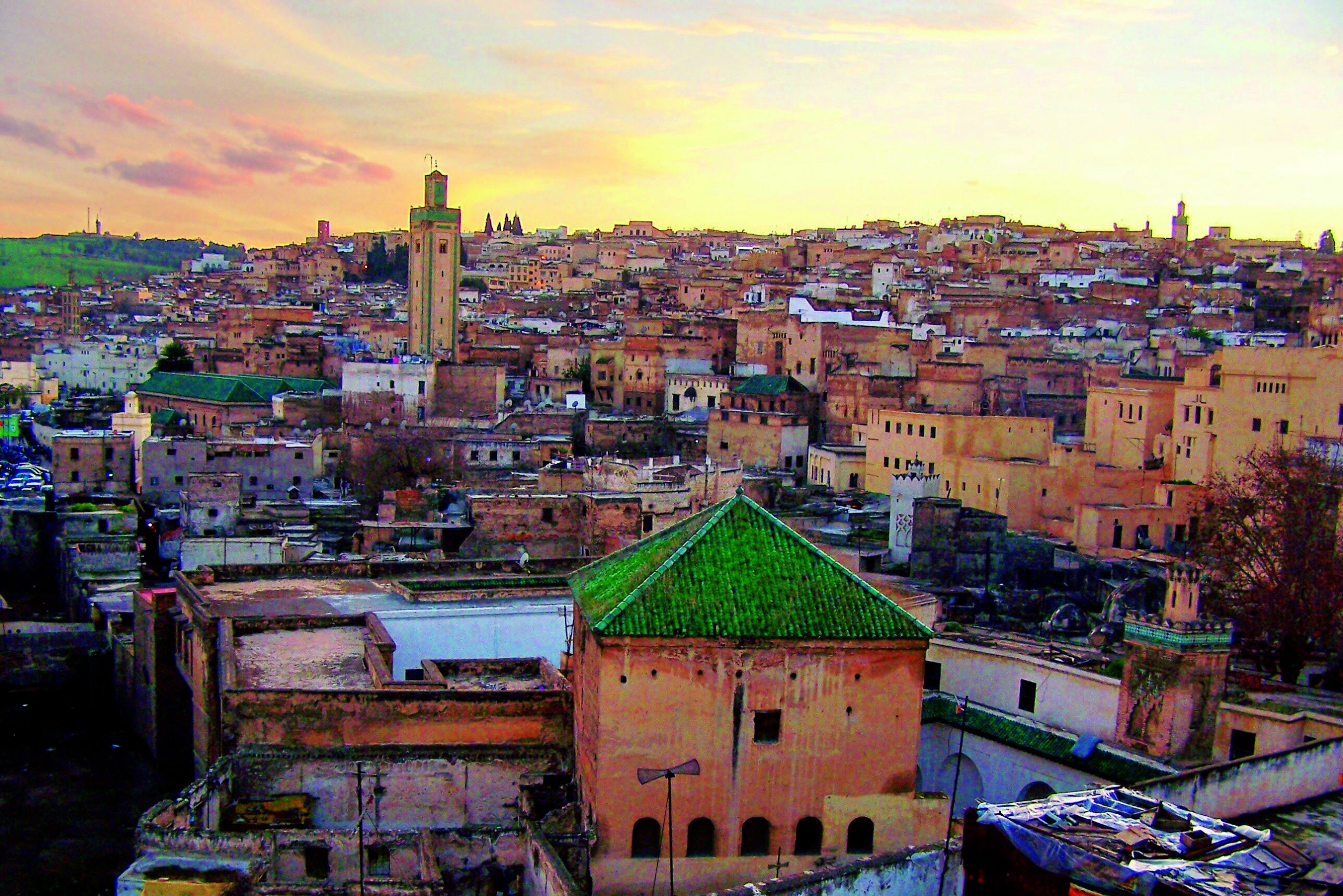
Marrakesh, as it was


Wonderful article Albert, like always, so much detail and
history of our beautiful planet, teaching and learning may it continue forever.
Well written, very informative, nice picture of Marrakesh, sad undertone and a competitor to this dangerous road:
Hardknott Pass
England
Condolences to the people in the area.
Thank you for this. I spent 10 days touring through the region in April 2018. A great circle connecting:Rabat-Mekenes-Volubilis-Fez-Erfoud-Rissani-Merzouga-Erg Chebbi-Todra-Skoura-Ourazazate-Alt Benhdaou-Marrakech-Casablanca. A most impressive potpourri of environments. This pretty much circumnavigates the Moroccan Meseta as show on your maps, crosses the Atlas Mountains to the desert, and returns. Ifrane, was as stunner. Carved right out of the Swiss Alps with “Le Chamonix Hotel, restaurant, cafe, and nightclub at its center. I fear and pray for the kind people whom I met, and might have suffered, even though the area traveled was NE of the epicenter.
It is always hard to write about a disaster area. We try to give the background and to avoid going into catastrophe bait. But it does affect you while writing. Denali wrote there is a sadness underneath. Isn’t it the same with volcanoes?
Good report in Guardian with news from villages. Video from a village in there:
https://www.theguardian.com/world/2023/sep/10/morocco-earthquake-mourning-begins-as-rescue-continues-with-death-toll-over-2000
This is a great and informative piece, I didn’t know much about the Atlas fault system.
2 questions I have are –
Was the Betics formed the same way as the High Atlas i.e. compression in a stubborn Iberian plate?
Do these faults carry on as far as the Canaries or do they stop beforehand?
I ask the second question partly because the Valencia trough seems like a continuation of the Betics fault system and has shown geologically recent volcanism also.
I don’t know about the Betics – perhaps Hector does. As for the Canaries, I first started to look at Morocco to see whether there was any connection. I could not find any. The faults don’t seem to extend into the sea.
There are basins underlying the Betics too apparently.
Yeah I saw one potential cause of Canary volcanism as a propagating fracture a while back but it doesn’t really add up – I had a look on the seafloor render on Google Earth Pro and couldn’t see anything that followed the trend, and it doesn’t explain the other nearby seamounts.
Besides Canary volcanism has similarities to Galapagos volcanism, and also sits on the edge of the African LLSVP (in an ultra-low velocity zone at the boundary) likewise many of the Pacific ‘hotspots’.
Thank you Albert.
Is there any data how offten occured EQ in one region. I ask for Europe-Alp/Nort Italy above 6.
There are quite a few earthquakes in the range M5.5-5.9 since 1900. There are some in south Belgium and the west of Germany, one in the North Sea south of Dogger bank (well before gas drilling, in case you wondered), west Poland, Slovakia in the Tatra mountains, four events close together south of Stuttgart (largest M5.9) and an M6.2 South of Bern which is on the north side of the Berner Alps. An M6 is certainly not excluded in the UK, southern Benelux, Germany, Poland, Czech Republic and Slovakia.
My guess is that a likely place for such an event is between Basel and Stuttgart. There was a sequence of high M5’s in the first half of the 20th century and nothing since.
Thank you once again.
I am from Slovenia and our last strog EQ was 1895.
I think Marocco and Turkey not have so much impact on Alp region in future.
Very nice article Thank you Albert
This area was also close to the CAMP basaltic flows I think, lava flows that was many thousands of km long : )
New eruption just commenced at Kilauea.

Magnificent the largest caldera fissure eruptions since 1974 althrough a bit smaller than that
But very Impressive
https://m.youtube.com/watch?v=tBh-ZhIB1Nk
Webcam
Looks like Kilauea behaves now a little like a Galapagos caldera just with higher magma supply rates, lots of pressure below
Fissures now .. still going very strong
Of course it happens right as I think it is fine to not look for a few hours… again…
And it happened in an area that I dont think anyone predicted, right through the downdropped block. Almost the same place as the old 1982 fissure by the looks of it.
This is somewhat in line with the fault structure of the SWRZ as it goes through Halemaumau and towards Kilauea Iki. But is different to the SWRZ connector where the strong quakes were before. Will be interesting to see how that responds as HVO noted that the inflation south of the caldera seems to be separate to that under Halemaumau. A SWRZ eruption need not be absolutely ruled out just yet.
Will also be interesting to see if this eruption lasts longer with vents outside the lake or if it calls it quits within 2 weeks anyway.
Whats the eruption rates ? Looks like many 100 s of m3 per second at start at least
Probably not a bad guess, not unusual for the start of these sorts of eruptions. It resembles the eruptions next to Keanakako’i in the 1970s.
Most likely there will only be one or two vents left in a few days. The fissures under the lake already died by the looks of it. Hopefully for viewing whichever vent it focusses to becomes a lava geyser 🙂
Perhaps we will get another cone and a lava channel into the rootless lake 🙂
There was a short lived lava fall too at the start : )
The big initial lava fountain has ceased after the first hours. Most of the eruption is happening on the down dropped block. Now the fissure ends where the previous lava field/lake of Halema’uma’u begins. The lava fissure has split/rifted the block more or less in two.
The location of the fissure is nearly perfectly the same as 4/1982:
That day the eruption only lasted 19 hours. The current one will very likely last longer.
It is a bit to the southeast of the 1982 fissure, which was visible on the livestream before the eruption started left of the fissures. But most of it is probably buried now.
Yes, and Halema’uma’u has changed its shape a lot with the collapse 2018 and new lava lake 2020-2023.
We must wait to see, where the eruption will concentrate. We are still in the “fissure” stage, but it are soon going to move over to “vent” stage with a certain vent to become the main location for the current eruption. The lava fountains in the lava lake have ceased completely and the fountains on the down-dropped block are already decreasing in height. I have the impression that the eastern part of the down-dropped block has the most vital fissure now. But it can change quickly.
Is the heavy lava in Halema’uma’u acting as a lid for the pressure?
Maybe the magma has now found a way to split the solid down-dropped block. That was old, aged basalt, while the hot and partially liquid lava lake was more difficult to crack.
However, the eruption has begun to become a Kalupele (name of the whole caldera) eruption. The lava lake of Halema’uma’u and the down-dropped-block would fill the half Caldera of Kaluapele. That’s many times bigger thant previous historical lava lakes.
The lakes from the first half of the 19th century up to 1868 were like the present one but all of the caldera… 🙂
But yes after 1868 there hasnt been anything like that up to the last few years.
Whoever had Kaʻū desert in the betting pool (including me)…sad trombone.
Ka’u can wait, volcanoes have more time to evolve their eruptions than humans have patience to wait. But sooner or later Ka’u is still in the game.
A beautiful sight as the sun goes down. Also noticed a small wall vent in the background.

Beautyful now imagine each fountain being 600 m tall and you haves an Ionian scale eruption 🙂
It’s on the wall between the down-dropped-block and the “normal” Caldera plain (Kaluapele). The eruption looks like the down-dropped block is going to become part of the large lava lake. The lava lake was previously already much larger (volume and area) thant 2008-2018, and now it fills the half area of Kaluapele (Kilauea’s main summit Caldera).
At the Kilauea live stream on Youtube, it looks like this is a series of parallel fissures.
I don’t recall having seen this pattern before, at least not at Kilauea.
Looks like a dike cut across the floor in an east-west direction, but because of all the circular concentric faults around the collapse it has created a really crazy looking surface expression.
But, if it has formed this sort of structure then unlike the last few eruptions it -could- be relatively free of needing to lift up the whole caldera block to erupt. So unlike before, this eruption could actually have potential to relieve all the excess pressure in the magma chamber, not just whatever can hold the lid up like a pressure cooker at its limit. This happened in 1959 too, just saying… 🙂
Of course there is still a 90% chance this will just spatter on for a few weeks then die off but at the very least this is showing that eruptions are now no longer confined to the ring faults surrounding the former deep pit of Halemaumau, although perhaps they will stay within the wider 2018 caldera a bit longer.
And If we gets one outside the 2018 downdrop area, we will have some spectacular lava falls to see 🙂
Althrough Pillan Patera is something else a pit the size of Reuinion thats floor was filled by lava
Any chance that an open conduit may form now ?
That makes sense. It’s an impressive show at the moment. The output must be phenomenal.
How many cubic meters have erupted now ? I see No problem making making at least a large VEI 3
It wont be nearly that large 🙂 but the effusion rate could have been similar to begin with. Most of these eruptions are smaller than they look but very intense. The two previous eruptions this year were less than 20 million m3. There is less than 200 million m3 of lava in the caldera, most of the filling since 2018 has still been underground, amounting to as much as 1 km3 of material, which is significantly more than the normal supply rate. It is likely that the supply will slow as the volcano fills though and puts pressure on the deepr system, so the supply of magma will slow down but eruptions could become more powerful and intense, or much larger in scale involving a rift.
Yes, I think this one is driven by rifting and not uplift of the caldera floor and exploitation of the ring faults. Could be more stable since the weight of the caldera floor won’t push down on the intrusion, and also since the vents are outside the lake, but who knows…
Douar Tnirt village looks very bad, one third down.
https://www.nytimes.com/live/2023/09/10/world/earthquake-morocco-marrakesh-news
Thanks for taking out my last comment. Was getting impatient.
……..20 summit in India.
Image in article, about one fourth down
A group Moroccans sitting on the ground outside with supplies.
A temporary shelter in the mountain village of Azgour, Morocco, on Sunday.Credit…Sergey Ponomarev for The New York Times
An impressionist photograph of rare beauty in between all the destruction.
A new Kilauea interferogram came up in the Mounts project page. It covers 12 days from August 25:
This data confirms our speculation that inflation had shifted to the SWRZ. To the Seismic SWRZ, the area of the 2021 sill intrusion, the area of the December 1974 eruption and dike, and 1981 major non-eruptive dike intrusion. There is up to 4-5 cm of inflation in 12 days over an enormous area many kilometres across, reaching outside the deformation map. At the same time magma has maybe been building up in the dike like deep rift beneath the SWZR. This is massive by world standards, and maybe even exceptional by Kilauea standards. In coincides with a continuous barrage of DI events and prodigious seismicity along the SWRZ connector/ top of the deep rift. Now we have an eruption that even though it’s in Halema’uma’u is different to its predecessors. For the first time we have a fissure that follows the rift structure of Kilauea. Earlier eruptions and intrusions were erratic, seemingly intruding the ring faults of the caldera, this was particularly clear for the earlier two eruptions. This one instead follows the rift, the dike swarm of Kilauea Iki-Halema’uma’u. This is a change, even if the location is still the same. It is the first clear involvement of the rift structure in an intrusion, even if at the summit, since 2018. Coincides with an spectacular activation of the Seismic SWRZ which is related to the summit and a continuation of the deep rift from the summit. It is an interesting development! I’m traveling so can’t pay much more attention to Kilauea stuff for the time being.
Do you think it will be larger than normal for a summit eruption?
I don’t fully understand why the last two eruptions were so short. Assuming it has to do with intrusion geometry, with the previous two eruptions being ring fault cone sheets and this one being a more typical dike, then this one could be different, maybe longer, more voluminous. But the reason why the previous two eruptions were so short could be something else, maybe having to do with interactions between the erupting conduit and the deep rift, so I don’t know anything for sure.
It is all the more interesting because they didnt behave as though a short eruption was going on, both of them but particularly the June eruption were quite strong and stopped very suddenly, and in a way that looked like nothing more than a slight pause but it still never resumed…
The way the SWRZ has been behaving, even though this eruption was in Halemaumau anyway, as you say it follows the structure of the rift zones not a caldera fault. And I was not aware of how huge of an area was actually affected by the inflation to the south, it was visible in the SDH tiltmeter and the GPS stations but the GPS is slow to respond and the tiltmeter is only right next to the caldera. It looks like there was strong inflation all along the whole length of the SWRZ connector not just at the edge of the caldera.
And the ERZ is dead silent, still… Looks like the SWRZ will get some time in the spotlight. As always, need I remind that nearly all of the lava underneath the Observatory flows is a’a, the SWRZ can really go big when things line up right, probably just as much as the ERZ does outside of the major caldera collapses at the far eastern end. With how well connected the SWRZ is to the summit, and how intense the 1974 eruption was despite its small size, it is possibel that SWRZ eruptions in time of high activity are actually even more intense than ERZ eruptions are.
The Observatory flows are old, medieval in age equivalent, which is basically eons ago in Kilauea time, if the SWRZ is about to do a major resurfacing in the next few decades we might be seeing something that hasnt happened in well over 1000 years.
Sometimes summit eruptions in Halema’uma’u preceded SWRZ eruptions. They are more closely related than the summit and ERZ. Do we already see the first half of a dual summit-SWRZ eruption? Difficult to predict, but would be interesting to watch.
Earthquakes around 2 km deep during times of inflation define a nice structure, usually referred to as the connectors. I believe this structure is actually the top of the deep rift, a permanently magma-filled, dike-like body, 2-7 km deep, that is largely unique to Kilauea. Regardless of its nature dike intrusions of Kilauea originate from different places along this structure. The dikes are represented in red in the image above. The Southwest Rift Zone can be intruded directly from Halema’uma’u, unlike The SWZR. Dikes can also start from portions of the southwest connector very close to the summit like in 1981 and 1974. The ERZ is more independent, there is a gap between Keanakakoi and Hiiaka Craters where dikes are minuscule and nearly always non-eruptive, because the deep rift is nearly perpendicular to the dikes there. This gap marks an important barrier, between the ERZ and the summit, that makes the ERZ as a whole much more independent from the summit than the SWZR. This can be seen when the rifts inflate. When the ERZ inflates it is usually centered in the Pu’u’o’o-Kalalua or even Heiheiahulu areas and separated from the summit. When the SWZR inflates it is like an arm stretching from the summit.
How can we distinguish live between pure summit eruptions and those who are precursor to SWRZ eruptions? How did the historical summit eruptions that opened SWRZ look like compared with the current eruption?
Just – again – a general caution, that where there’s magma about, the aseismic ‘gaps’ in a structure can be telling you *where the magma is* – where the rock is too hot and ductile to undergo brittle fracture.
I think that can be misleading. It is true that magma doesn’t make earthquakes, earthquakes happen in the rock next to the magma. But not just any rock will do, you look for rock that under strong strain that forms faults. Here you have a rifting area under strong strain, in my opinion the earthquakes happen immediately above a large vertical dike-like body of magma or mush, the rock roof is stretched apart as this body grows and the flank moves south. Regardless of the shape of the body responsible, the connectors are clearly magmatic structures. Kilauea has seen tens of documented dike intrusions over the last decades, the first earthquakes always happen in the connectors. If the dike surfaces, the first fissure opens near the connector and then keeps opening away from it. Not to mention there are several collapse craters along the eastern connector, Makaopuhi and Napau for example, which are like tiny calderas, as well as a large area that regularly experiences ground inflation along the southwest connector. When you see a ring earthquake pattern you are probably dealing with the ring faults of a caldera system.
Here is the structure in more resolution:
1 and 3 are the sections of the deep rifts or connectors that are highly oblique to dike intrusions. Their obliquity seemingly prevents large dikes and possibly sills from starting in those areas. A sort of gap. The ERZ’s gap is bigger.
https://www.usgs.gov/volcanoes/kilauea/summit-webcams
More webcams of the eruption
Rough guess at where the vents are. Plotting it out on here actually shows how big this eruption really is, over 1 km long, bigger than most of the 20th century summit eruptions. The taller fountains are probably pushing 100 meters at the start, and still tens of meters right now. Still remains to be seen how long this eruption will last but the potential seems to be there.
Probaly a cause of the increased magma supply Thats very much higher now than it was in the 1950 s or 40 s .. we are entering a incredibley dynamic era at Kilauea
HVO update, the fissure is 1.4 km long, which is what my estimate was. The fountains are 20-25 meters tall now so perhaps closer to 50 for the start, and over 100 for the fountain first spotted. Not as high as last eruption start but then that was a little different.
Estimate of effusion rate and map of vent locations coming soon 🙂
How high where CAMP fountains ? where they many thousands of meters tall or No taller than Mauna Loa fissure just much longer fissures?
Camp coud also have been overflowing pahoehoe lava lakes as well that where 100 s of km wide.. we will never know
Probably the same sort of scale as fountains we see in normal eruptions, there is a limit to how big the fountains can be before just being an explosion. Although it is far from impossible some LIP eruptions began with a plinian stage or were bimodal explosive/effusive in particularly intense eruptions.
It is easy to forget that LIP provinces would have had normal sized volcanism too. Maybe even such places were clusters of normal scale shield volcanoes that occasionally erupted way bigger, like a basaltic supervolcano.
That beautiful city built partly of marble found deep in the nearby mountains crumbled. That is only a side thought.
Basically this is the old heart of Pangaea and the transpangaean mountain chain and is red like e.th. that was close to it including the coast of West Dorset.
I am not persuaded – looking at maps – that in doesn’t go on in the west with a submarine part ending somewhere near The Canary Islands or Madeira. With eroded volcanic mountains on the bottom of the Atlantic Ocean or on the shelf.
This is from Brazil though, former neighbour – yesterday 🙂
Azul de Bahia
Fun to think that Madeira is still alive its a beautyful place with for many better weather than Hawaii as its less sultry and stylish archictecture
Madeira maybe able to form a alkaline monogenetic cone one day as last time was just a few 1000 years ago, will probaly look like La Palma If it erupts again with deep alkaline magmas, most of the previous polygenetic edifice is deeply eroded
“The High Atlas Mountains themselves are riddled with short faults. Why so many faults? And why does Morocco have so many mountains anyway?”
Let me suggest another idea. Some think that a big part of these mountains, the base, are the old Transpangean Mountain Range, the center, eroded now as they are supposed to have had the height of the Himalaya. If yes the faults make sense.
The mountains caused by the African Plate colliding with the Eurasian Plate would be further north between the Pyrenees/Appenine/Alps and the Himalaya.
These Southern ones might have travelled with parts of Spain and the Baetics when the MAR opened, so s.th like 150 Ma or a little less.
So if it were two different things the faults would make sense esp. because of the angle between the northern mountain chain and the Atlas/Baetica.
There would then be two zones, one older (fragment of Pangaea), one newer. Just an idea. The marble got me there. If there was indeed a mare like The Transsaharan Seaway there would also be signs for subduction somewhere. But this doesn’t seem to be sure, and Mosasaurus fossils could as well have come from the Atlantic Ocean in the west.
Altogether I wouldn’t say that there is too much research in the area, and some papers are in French.
The idea might also be rot. I don’t really know how long it takes in an always dry climate to erode a mountain chain with the same height as the Himalaya. It doesn’t seem to have rained a lot in the center of Pangaea. The split obviously must have happened between the Appalachian Mountains, the Atlas, Brazil and Armorica.
Another reason for the many short faults migh be that it is sort of tight there, so the direction might be changed from time to time.
Just thoughts, partly from another source.
The Appalachians have survived, so they can last a long time. It has indeed be suggested that some of the faults are ancients in the deep bed rock which have reactivated and affected the overlying crust. I could not see evidence for that.
French publications are not a problem but I did find that French authors can be more technical, and harder to read for a non-specialist. In the end it is more important that the work is open access. Geologists seem to have a significant problem with that idea.
Then, if this is the old center of Pangaea it is also the old center of the source of the CAMP. This means there could be slabs or pockets of molten rock.
If there is a connection to the Canary Islands it would be much easier for the magma to get out in the open sea, in Gran Canaria, Tenerife, Lanzarote, El Hierro and La Palma esp. as there is possibly a slope from east to west. Yet earth would move there.
Just thoughts, if not plausible, feel free to tell me. As I said, not much research. Maybe in Arabic.
Altogether it doesn’t help the people there now. It might be important though to watch the Canary Islands closely. Just in case.
One source though:
“The 3-D inverse modelling of a magnetic anomaly measured over the NW submarine edifice of the volcanic island of Gran Canaria revealed a large, reversely-magnetized, elongated structure following an ENE-WSW direction, which we interpreted as a sill-like magmatic intrusion emplaced during the submarine growth of this volcanic island, with a volume that could represent up to about 20% of the whole island. The elongated shape of this body suggests the existence of a major crustal fracture in the central part of the Canary Archipelago which would have favoured the rapid ascent and emplacement of magmas during a time span from 0.5 to 1.9 My during a reverse polarity chron of the Earth’s magnetic field prior to 16 Ma. The agreement of our results with those of previous gravimetric, seismological and geodynamical studies strongly supports the idea that the genesis of the Canary Islands was conditioned by a strike-slip tectonic framework probably related to Atlas tectonic features in Africa.”
https://www.nature.com/articles/s41598-017-18813-w
The direction of the structure is interesting: “elongated structure following an ENE-WSW”
The location is inviting.
There is no proof for a mantle plume under the Canaries as no fitting trail, submarine volcanoes in chaotic order.
perhaps also seems to cool right? but there haves to be something that cause a volcano in canaries
Old structures could provide ready pathways it must be said.
I believe the Canaries to be caused by multiple sources, it exists in an area of extension also and possibly some fractures from the MAR. It’s rift structure follows a clear pattern that aligns parallel to the continental shelf. However the geochemical signature is that of mantle material and it does have a line of progression of sorts. It sits at the edge of the African LLSVP, in the transition zone where a lot of hotspots seem to appear (ULVZ).
The lack of any activity at La Gomera is puzzling however.
canaries also dont have the chemistry of the larger iceland and hawaii althrough melting is lower in canaries
Morning over the eruption
Pretty.
The US have some great painters I am looking at since a short while ago. This is Mount Adams from German-born Albert Bierstadt-Storm
That does not look like Mount Adams in Washington – where is that?
Artistic freedom.
Mount adams, Washington, Princeton University Art Museum, New Jersey
This comes close:
Cascadian climbing party before ascent, east side
Notice the cones being built now Islands in a searingly hot sea around them
Don’t be so modest, Albert!
“Albert Zijlstra, professor in astrophysics at the University of Manchester, said: ‘We are amazed by the details in the images, better than we have ever seen before.
‘We always knew planetary nebulae were pretty. What we see now is spectacular.’
https://www.dailymail.co.uk/sciencetech/article-12369125/How-sun-look-dies-James-Webb-captures-final-chapters-stars-life-never-seen-snapping-extraordinary-images-Ring-Nebula.html
Congrats!
He’s our Carl Sagan.
I really get that vibe reading his articles, in the absolute best way possible.
I doubt this:
“The Chicxulub impact unleashed the force of about 8.5 billion to 10 billion Hiroshima bombs; the Vredefort impactor would have had roughly twice that yield, he said.”
https://www.livescience.com/biggest-explosions-on-earth
I doubt the numbers because intact skeletons were found in Tanis, North Dakota, part of Hell Creek. Okay, there were also broken bones, but a seiche or a tsunami has the force to break bones.
I doubt the numbers and others doubt the effect thinking it was too – guess –
small:
https://ui.adsabs.harvard.edu/abs/2016AGUFM.P33D2191B/abstract
Is Chicxulub Too Small to be the Source of the K/Pg Boundary Layer and the Cause of the Dinosaur Extinction Event and would the Amazon Basin Considered as an Impact Feature fit the Evidence Better?
This means that the numbers might be wrong. Even when they tested Trinity they didn’t know if that had all the numbers right or whether the atmosphere would start burning. It wouldn’t be a shame then.
This isn’t solved. And this comes pretty early:
https://eu.usatoday.com/story/news/nation/2019/10/24/rise-mammals-trove-66-million-year-old-fossils-discovered/4082963002/
The number 66 has crept into e.th. Before it was 65. interesting that this could live with that estimated climate change, sulfur, loss of life and plants and trees and become so big.
This is plausible. Pretty big though:
https://gizmodo.com/origin-mystery-of-ancient-rhino-like-mammal-solved-by-5-1827194003
And this is certainly interesting:
https://www.science.org/doi/10.1126/sciadv.abn3096
Nadir.
Didn’t belong here. Wanted to agree. Carl is an ingenious recruiter, let’s not forget him. Our Carl.
Sorry for the dino debate here.
Gone anyway.
Denali, no worries. Frankly the Chicxulub debate / commentary on the prior article comprised one of my favorite comment sections on the site. While I don’t have much to personally add, it was a fascinating discussion.
I love when you guys discuss the mesozoic and especially chicxulub, I never tire of it.
I have some more fascinating stuff. There are two tales in the area. The other one is the story of the Caribbean Plateau, the Iceland of the Americas.
That Plateau is supposed to have travelled for 60 million years to where it is now with its eastern rim, the island arc of the Antilles. It was able to do that riding on the Farallon Plate because Middle America wasn’t in place. Instead there was a part of the Tethys Ocean with a – guess – spreading ridge. The CP, a submarine LIP, is supposed to have started over the Galápagos hotspot. After that it was fed by the spreading ridge.
The first time it got as stuck like the Hikurangi Plateau/Chatham Rise got stuck east of Zealandia, subduction of the Farallon Plate becoming a bit difficult, was when it hit the American Plate in the north, that’s to say at its southwestern edge. At the (fitting time) conveniently a meteorite came in and left a crater with a crater rim unusual for every other meteorite crater on earth but found in huge numbers on the bottom of the Pacific Ocean.
Get it?
It might be a volcanic caldera. There are reasons for that. One, the tale of the Caribbean Plateau travelling east plus the geography (no Middle America) and the unaltered setting by people dreaming of asteroids don’t match. Second, e.th. is analogous with this setting which has the Taupo Volcanic Zone:
https://upload.wikimedia.org/wikipedia/commons/8/84/Zealandia-Continent_map_en.svg
It is just a bit more complicated to figure it all out, debunk the asteroid theory and deprive people and media of a cheap horror story. The equivalent of 300.000 years of sediment in the crater after an event (research from Princeton) makes it even more complicated. The tsunami would have been high enough to take down all life close to the remanant of the Western Interior Seaway and the American South Coast and explain the findings in Tanis.
The Iridium Spike in Gubbio might have been caused by the smaller asteroid in Nadir.
Whatever, the two tales and all maps of the area don’t match.
Maybe that is why it occurred to me in connection with Kerguelen. There were many Icelands. And more Katlas or Tobas or Taupos on the bottom of some oceans.
Try these maps as well:
LIP around Australia and NZ:
https://en.wikipedia.org/wiki/Ontong_Java_Plateau#/media/File:Map_showing_the_location_of_oceanic_plateaus_(in_green)_in_the_Australia-New_Zealand_region_of_the_South_Pacific.svg
Coming and going of species with volcanism. Much more interesting, btw., to figure this out, even in case it might be wrong. In any cas a volcanic plateau cannot fly through Middle America like a ghost.
It is sort of logical mechanical thinking. Albert Einstein talking about his Italophilia called Germans “automatons”. Sorry for that, Einstein. Gerta Keller is originally from Switzerland, and they are similar. And Alfred Wegener did the very same thing. It is painful to debunk fantasies. It just doesn’t fit.
And the beasts haven’t died altogether. They were just gone at some point. It wasn’t their climate, their plants, their food anymore. And the pressure inside their huge bodies might have stopped to match the pressure from the surrounding air.
A submarine when it goes down to far can get lost, and a diver coming up to fast can die. Mercury poisoning might have added to their demise. Last but not least, most of them lived near shores and were omnivores, so must have also fed on fish. But basically this is another story than the story of the Caribbean Plateau and its surroundings.
In case the asteroid came in after all it is a funny coincidence that it hit right next to the Caribbean Plateau which wandered through Middle America and Yucatan like a ghost.
Working through the comment section on the Kerguelen article was my ‘evening workout’ for at least a week. Seriously, it was fascinating stuff.
There is s.th. else with those dinos that fascinate us so much that some people (maybe wrongly) love or at least regret them.
At some points the Black Death waves were finished, the population had declined to one third if I remember right, People had left their children alone. There had been some cannibalism.
With those dinos it was worse: They had cannibalism all the time. Only a small fraction of baby T-Rex became adult, it is estimated. If we had cannibalism all the time, without the Black Death or extreme situation like floating in the Pacific Ocean or being stranded in the Andes we would most certainly die out. It is like with the Easter Islands: When you take down all trees, one day there is no tree left. Brazilians should listen to this.
And then, as to the analogy of the Black Death: As there were rodents they must have had viruses as well. If the Black Death waves hadn’t stopped at some point, possibly due to some develloping immunity, Homo Sapiens could have gone extinct. Taken down by the flees of rats. Not very spectacular at all.
The sheer enormity of things that could’ve been the extinction of either us, our direct lineages, or distant ancestors back throughout time is absolutely mind boggling. The fact that we’re here at all despite is really difficult to wrap one’s mind around considering this.
The Great Filter may simply be a semantic assemblage of the above. Dinosaurs ruled for 150 million years but didn’t progress to technological intelligence, mammals did it in much less time. Perhaps there are other planets out there with ‘dinosaur equivalents’ (intelligent but not technologically intelligent species under no evolutionary pressure to become more intelligent) and that’s a big part of why there may be so few truly advanced civilizations out there.
The more I think about just how many things had to come together for us to be where we are right now, today, sitting here communicating with one another invisibly is just staggering.
To be fair, the sort of stuff we have done to the planet that would show in the geological record for millions of years is really only post-1700. Before that the only record would be a weird overabundance of bipedal primates, small canids, and very particular types of even toed ungulates.
Even at that, it isnt clear how long that traxe would persist either. There could have been dinosaurs with capabilities comparable to our own but which didnt industrialize or develope agriculture, being nomadic hunter gatherers or ‘just another animal’. Considering how smart a lot of birds are, birds that diverged pre K-Pg mind you, and also how smart crocodilians actyally are too, it seems just really implausible dinosaurs were all mindless idiots. Brain to body ratio is one thing but when your body is gigantic that 0.1% isnt so tiny as it sounds… 🙂
Carl will Re – appear when Grimsvötn erupts thats the most intresting volcano for him
What if not? 🙁
Grimsvötn have stable constant supply just nowherelse near Kilaueas ammounts
So it cannot remain silent forever, its already getting to the breaking point .. But coud be a few years more until it goes next, but highly unlikely to go 10 years more without sleep, but many Grimsvötn eruptions are also small and barely breach the Icecap like the 1930 s – 1990 s lull
M5.0 north of mt lassen on friday gave us a nice roll at my place about 45miles from the epicenter.
The faults north and south of lassen are now active. All indications are the vatious jolts are tectonic in origin…but this is volcano country afterall.
The lava flows seems to have broken through the crust on the 2020 – current rootless lava lake and are now just soaking into it without flowing over it
A family of spectacular lava fountains has occured now: https://www.youtube.com/usgs/live
They look very healthy, as if they can continue for a while. I hope that HVO soon will publish a new map.
New maps up: https://www.bigislandvideonews.com/2023/09/12/kilauea-eruption-changes-charted-in-new-usgs-maps/
Parallel to the 8/71 and 8/74 eruptive fissures, and pretty close to parallel to 11/59.
Parallel to where those fissures sit now after 2018 but probably more in line with the Halemaumau-Kilauea Iki trend. Which, naturally, does bring up rift eruptions being a possibility in the not so distant future.
Indeed, HVO has published both a thermal and a physical geographic map with the new eruption. Most of the down-dropped block is already flooded, and the lava lake has got a new layer. There is a short, but broad lava flow from the block towards the lava lake.
If the eruption lasts long enough, all will become a giant lava lake. Half of Kaluapele (the “mother” Caldera of Kilauea) a lava lake. This lava lake would be appr. 3km long and 2km broad. That’s the size of Lake Albano (near Rome).
On Io the caldera pit coud be as wide as Big Island and same scaling with the lava flows from fissure eruptions, Ionian basaltic eruptions are truely apocalyptic in scale
Fun you all enjoyed the Pillan Patera piece .. three lava falls, each 3000 m high and 25 km wide during that event
In the comming winter juno will visit Io and we will get New closeup photography, and in one orbit the probe will go as close as 1500 km from Io
I don’t know whether I wrote a comment there not knowing enough about the Galileian moons, but I got interested which is always a start to learn more. The icy moons with suspected water underneath are just as interesting. I had never heard of Pillan Patera before.
Meet Fujianvenator prodigiosus:
Bridging the Evolutionary Gap: Paleontologists Discover Bizarre New Species of Bird-Like Dinosaur
https://scitechdaily.com/bridging-the-evolutionary-gap-paleontologists-discover-bizarre-new-species-of-bird-like-dinosaur/?utm_content=cmp-true
The original article
https://www.nature.com/articles/s41586-023-06513-7
costs 25 Euros minus 1 cent, what a joke. Limited number of readers therefore.
Volcanic rocks
Fujian has two volcanic rock provinces. The East Fujian-Taiwan volcanic rock region includes a strip along the coast. The rest of the province falls into the Zhejiang-Fujian-Guandong volcanic rock region. Both are part of the South China techtono-magmatic province. The Zhejiang-Fujian-Guandong volcanic rocks are mostly rhyolite and dacite rich in potassium, from Late Jurassic to Early Cretaceous. The magmas were formed in an environment first under compression, and later under tension. The East Fujian-Taiwan volcanic rocks in Fujian formed in a continental shelf environment, with alkali basalt erupted around 11.65 Ma on the coast near Fotan.
https://en.wikipedia.org/wiki/Geology_of_Fujian
https://www.researchgate.net/figure/Distribution-of-Cretaceous-igneous-rocks-in-the-Zhejiang-Fujian-area-SE-China-modified_fig1_222698194
It was a good place to survive the Triassic-Jurassic extinction event and slowly develop the quality of flying in the course of the tens of millions of years, out there, on the banks of Tethys.
It is a very nice reconstruction. They are so able. They don’t need spies, being as able as anybody else.
Insane lava flows .. some where thousands of km long, some CAMP eruptions where probaly larger than most Ionian eruptions today
The Province have long since broken up and is severely eroded today
Donovan got it early:
“Stop complainin'” said the farmer
“Who told you what had to be?
Why can’t you have wings to fly with
Like the swallow so proud and free?”
[Pre-Chorus]
How the winds are laughin’
They laugh with all their might
Love and laugh the whole day through
And half a summer’s night
https://genius.com/Donovan-donna-donna-lyrics
They survived, Jesper, no worries. All their genetics are preserved. It is just some variations who died.
“Look at the birds of the air, for they neither sow nor reap nor gather into barns; yet your heavenly Father feeds them.” Matthew 6:26-34
I’m impressed.
Roadrunner. Southern California:
Kentish Plover
Oystercatcher, Helgoland
The oystercatcher’s home:
yellow summer, blue winter, green all year around
Today I got the second noisy miner (Manorina melanocephala) chick of the season to accept food from my hand! The third is holding out. Spring is here, down south.
I have lots of friendly dinosaurs who come to my house.
I wonder if the western zone movement of Africa north is about to seize up. The subduction zone south of Spain seems fairly dead. There’s more momentum around Italy and Greece, so perhaps Africa is swinging anticlockwise pivoted on Gibraltar.
Not even a week after this earthquake, a massive flood smashes Libya. Absolutely insane. I never thought MTlC storms would be this year’s deadliest weather disaster so far.
In the MeteoSchweiz-blog (Swiss weatherservice blog, highly recommended for German language readers! High standard.) I read it was the same low that caused flooding in parts of Greece and neighbouuring countries the 4. to 7. september. The low did reactivate above the warm Mediterranean Sea forming a socalled Medicane. Medicanes occur about once a year, in autumn when a ‘cold-air drop/pool’ enters from the north into the Mediterranean area.
The Libyan weatherservice published data on the rainfall: 150 to 240 mm within 24 hrs on the est coast area. Top was Al-Bayda 414 mm.
I think most of the heavy flooding did occur because of some waterreserve dams were destroyed by the heavy rains. Parts of inhabited areas were completely washed away. Several thousands casualties estimated.
Zwischen dem 4. und dem 7. September hat ein stationäres Tiefdruckgebiet extreme Regenfälle in Griechenland sowie in den benachbarten Ländern Bulgarien und Türkei verursacht. Danach verlagerte sich das Tief unter vorübergehender Abschwächung Richtung Nordafrika. Über dem warmen östlichen Mittelmeer verstärkte es sich erneut und entwickelte sich zu einem Sturmtief, auch Medicane (Sturmtief im Mittelmeer) genannt. Am 10. September erreichte das Sturmtief die libysche Küste mit sintflutartigen Regenfällen und heftigen Winden.
Regenmengen und weitere Beobachtungen
Am 12. September publizierte der libysche Wetterdienst eine Zusammenfassung der gemessenen Werte während dem Durchzug des Sturmes. Gemäss dieser Mitteilung fielen in wenigen Stunden flächig zwischen 150 und 240 mm in 12 Städten der östlichen libyschen Küste, unter anderem in Benghazi, Al-Bayda, Shahat und Derna. In Al-Bayda wurde die höchste Regemenge, 414.1 mm, gemeldet. Die Meldung des libyschen Wetterdienstes gibt den Zeitraum der Regenfälle nicht an, aber das ganze Ereignis fand während nur einem Tag statt und somit gelten die Regenmenge für höchstens 24 Stunden. Zudem werden Sturmböen zwischen 70 und 80 km/h erwähnt, was für Schweizer Verhältnisse nicht extrem erscheint. Allerdings sind die Messungen gemäss den Wetterkarten-Analysen wahrscheinlich stark untertrieben.
German part taken from MeteoSwiss blog.
Islamist and warlord area, two dams not taken care of. The dams were there in the first place, so this is nothing new. New is only that the dams are not taken care of any more. If this happened in the Netherlands, the Netherlands might be gone soon.
Don’t send any money in that direction, it will disappear in the pockets of warlords. Morocco is better.
Denali, let relegion and politics be in this blog please!
It’s an extraordinary meterological event that would surprise every country. Medicanes and Medistorms are destructive, as we see in the old scriptures of prophet Jona and Apostle Paul. This time there was a real Medicane, a subtropical storm. In future those storms may happen more often and hit Italy, Greece, Turkey, Egypt.
It’s true that some governments are better than others to cope with disasters. Some have more money, some have less. Some have better priorities than others. It’s difficult to estimate the probability for disasters. Humans tend to underestimate it, because the have plenty of nice things to spend money for. Political disaster management is an interesting subject that can be discussed on a factual level without emotional disputes. It’s good that Libya has some friends that have sent help now.
You are seeing a connection?
I don’t think so. The Atlas is connected to the Sierra Nevada, Spain, western Mediteranean. The cyclone-like storms were in the eastern Mediterranean between Greece, Turkey, Lybia and Egypt. They have started in Spain though about ten days ago, but the cyclone develloped in the east.
I am wondering whether there is any connection to those anti-cyclones before.
Who is seeing a connection?
Me. It was a q though. I am wondering if this has anything to do with Cerberus and the following anti-cyclone. Maybe Craig Haiden has s.th. to say about it.
Libya is actually the worse disaster. The insane rain was bad enough but the damage was done in large part by the two collapsing dams, with the city right in the way of the dam burst. The death toll is guesses only at the moment but seems catastrophic.There are many dams across the world which are reaching the end of their service life. My town was partly evacuated a few years ago when a dam upstream began to crack. The US has around 10 dam failures each year, and about twice that many which require emergency work to avoid failure, mostly in dams that are 50-100 years old. Failure most commonly comes from overtopping, as probably was the case in Libya.
“Ahmed Madroud says dams have not been maintained since 2002, and damage from floods will be difficult to repair.” From Al Jazeera
Besides they might have been damaged before:
https://en.wikipedia.org/wiki/Battle_of_Derna_(2018-2019)
Best report. You might be able to read it, and the others have to run it through some translator if they are interested.
https://www.nzz.ch/international/libyen-tausende-tote-nach-sturm-daniel-befuerchtet-ld.1755745
It also says that the Mediterranian Sea was 2°C warmer than on average and the Black Sea 5°C which would be a follow up of at least to long lasting anti-cyclones over the desert Sahara one of which was called Cerberus as it had three heads, one reaching up to Greece/Turkey, one to Rome/Italy, the third to Spain, France was spared. Cerberus is woth to be googled. It lasted an eternity.
corr. two instead of to
The article also says that Turkey, Qatar and the UN are helping and that local rivalling clans might use the situation for themselves on the cost of the local people which is probably realistic.
The next country in danger is Egypt as the cyclone – as of yesterday – was moving there.
How is the effect of the Iberian micro plate on Morocco? The Iberian plate is turning clock- or anti-clockwise. It is one of several micro plates between Europe and Africa. The Atlas looks like the “Anti-Alpes”. The Alpes were created by Italy’s Adriatic micro plate that is a micro plate of Africa that collided with Europe in advance to Africa.
Map of the new lava at Kilauea by HVO today.
There is possibly also still an active vent under the lake, the graph displaying its elevation is a laser range finder that points at a spot that I dont think was actually ever covered by this eruption, but which has still showed 5 meters of uplift. The uplift could be from the new lava breaking through the crust from above though, or from just the weight of the new lava flexing the crust. Probably a combination of all of these things I guess.
SO2 emissions peaked at over 100,000 tons/day at the start, maybe even higher, which is an average of most likely over 100 m3/s the first day. The peak value when all the fissures were active at the maximum extent was probably more like 1000 m3/s although not for long.
The eruption seems to have settled in the middle of the fissure, outside of the lake again but much more vigorous than in June. The deflation is also still strong, not as much as the first day but evidently the effusion rate is high. The last two eruptions didnt relieve much pressure, not the case now it seems, the high effusion rate could continue until the lake rises above the vent and drowns it, which considering the elevation might be in quite a while, the vents are about 940 meters elevation while the lake is at 920.
The largest rootless lava lake on the planet very Impressive stuff indeed
I was trying to stock up a bit of information about lava lakes and – believe it or not – the most interesting piece I could find is this one. You are in it as well, and also Einstein is mentioned briefly:
“Luckily for us this has been observed briefly during one of the Krafla Fires eruptions. During a smaller eruption two fissures opened up at the same time, one erupted lava, but the other one was dry. The lava from the first rapidly flowed into the other and disappeared.”
https://www.volcanocafe.org/lava-lakes-the-great-equilibrium-machine/
From Carl, 2019
Stopped too early.
“But, in the case of Kilauea we have the potential that a rift opened towards Pu’u O’o and helped to feed that eruption. It does not explain other lava lakes where there is no sub-eruption going on.
This part requires further studies from young strapping scientists, and I will happily leave it to them. In our particular case, this is not where we will find the answer to Jesper’s question. Instead, let us discuss size and flowrate of ejecta.”
Interesting read
It is amazing to read old pieces and comment sections. This is great:
Irpsit
05/10/2019 at 22:09
Unrelated to this: I just have been noticing how seismic activity in Reykjanes peninsula in Iceland seems to have increased in recent months. This follows a pattern observed in whole Iceland, linked to increased plume activity. However Reykjanes was already seismic before, so any increase in activity could easily lead to an eruption there. Something to keep an eye on.
Personally I am betting that Reykjanes will have an eruption sometime in the next decade or so.
Its just lava filling the 2018 s pit .. there is No open conduit below it like it was in the 2008 – 2018 overlook summit lava lake that was basicaly a shaft down into the magma chamber, with a milimeter thin mobile crust that was Impossible to walk on
The current one is a stagnant pool thats frequently filled by fissure eruptions and been filling since 2020, between the eruptions the rootless lava lake develops a meter thick crust that you can walk across
Maybe we should rather call it a lava layer cake which is partially liquid. Each eruption since 2020 has put a layer above the previous lava layer. The layers are likely more or less still intact, only interrupted by new fissures/intrusions.
It is really a single layer, with progressive thin layers of new lava added to the surface crust by each new eruption. The lava lake is completely liquid inside still and probably barely any different in temperature to when it was erupted, at 400+ meters deep. The first lava to erupt in the ongoing eruption was near the edge of the lake but noneltheless still within it, and formed a tall but very voluminous fountain while the fountains erupted outside the lake on the downdropped block were almost explosive, with tall jets of patter going probably over a hundred meters above the stable fountains.
Also that in June the vents opened pretty randomly all over the crater floor even though the intrusion would have been a dike, and probably closer to the north edge of the lake.
Probably there is a layer of semisolid material at the bottom, from way back in 2020 when the crust would still founder frequently and the slabs of crust sinking to the bottom. But this might only be something like 10 meters, or ~2% of the depth of the lake.
Basically, at this point the lake in Halemaumau could be thought of as a very shallow magma chamber, almost completely liquid, although at least so far not continuously connected to the rest of the magma system.
The lava lake nearly never had any convection from source to surface. Often the lava flowed into the lava lake from sources above (rootless lava lake unlike rooted lava lakes). The lava lake is very different to the 2008-2018 lava lake or Puu Oo’s lava lake. It is more static. What comes in, stays in forever (until next collapse 😉 ). So I thought that this static lava lake only makes layer on layer but doesn’t mix them.
Actually from September 2021 to 2022, about a year full, there was a continuous connection. I saw it personally 🙂
But yes still different to the 2018 lake. That being said the current vent is proving to be very robust, building up some sizable cones and still fountaining strongly. If this goes on another week or two the cones might merge into one vent, which could become a proper conduit like happened at Mauna Ulu and Pu’u O’o. Halemaumau itself was once like that, a lava shield in the late 19th century up to the 1880s I believe.
The present video (I’m not sure which link works) shows five vital fountain cones rising slowly above the block. In the background maybe a sixth cone.
https://youtu.be/tBh-ZhIB1Nk
[youtube https://www.youtube.com/watch?v=tBh-ZhIB1Nk&w=1167&h=656%5D
While the June lava shield grew from the SW corner of Halema’uma’u, the current lava shield grows from the opposite NE side. So two flat inclined planes meet each other from two opposite directions.
Something about this eruption that might turn out to be important, it is in the center of the 2018 caldera more or less. The deep pit of Halemaumau had to fill first but now it has done so the stress fields changed a bit to allow eruptions in other areas.
The eruption is also still going quite strong, not with huge outflow anymore but the fountains are still going, and building some pretty big cones about 20 meters tall.
To me, this looks like it could turn into something much more persistent, and forming a large lava shield or a cone, a new open conduit like Pu’u O’o or Mauna Ulu. Although it might not last too long before setting of an eruption to the southwest if the recent data means anything.
What is the material in the down-dropped block? I imagine that there is partially old, pre-historic tephra (f.e. of 1790 eruption) that may be moved by the present fissure again.
S.th. daring. I discovered that physics and atronomy including maths has been daring since a long time ago, think of Kopernikus, Galilei, Martin Beheim and jump to the physicists of the first half of the 20th century (include some chemists, some physicists even started with chemistry) and then jump to today’s astrophysicists and even jump back to Pythagoras.
Compared with them and their mindset many geologists and also paleontologists are boring, drilling and shoveling, looking only at small details, lacking the big picture. There are exceptions though.
So, I dare. What seems certain is that say 70 Ma there was a big gap filled by an ocean between the two Americas. North America was attached in the north (Greenland, Norway, structures of Laurussia) is imagined as an oblique structure from NNW to SSW lying roughly parallel to the Caledonian mountain chain. Tethys is old, very old and is being subducted in the South. Wether you call it Pacific Ocean or Tethys in the area of the Transmexican Volcanic Belt is irrelevant in this context, certain is that there are rocks of the Cocos Plate in that belt.
So, where was that? North America has travelled south and rotated anti-clockwise. And where was Yucatan? Was it attached in the north-west of where it is now (with this model), not there at all or an island arc further south? That is the big question mark. We are not talking an asteroid hitting 5-10 Ma, but 65-66 Ma. We are talking the remnants of the continent of Laurussia.
If it was significantly further north and west (rotation) could it be that it was above the Yellowstone mantle plume?
No, this is too daring, isn’t it. I looked at it many times and turned it around. It doesn’t seem completely impossible. A caldera this size would easily explain why some of the fossils in Tanis arrived in toto, an asteroid would not, much too powerful. It would also explain why most fossils are not found inside three meters of the KT-line (the three meter problem). Tanis is – as far as I know – the only site with fossils close to the KT-line. And Belizes tektites are discussed for another origin as well. Gubbio’s spike could have a connection to the Nadir crater on the Guinea Plateau, West Africa, submarine.
It is a bit daring, I know, but exciting I think. Certain is that the setting was not like it is now, and the theory of the asteroid is a bit too simple with not enough evidence for a worldwide 70-75% extinction
in the 24h afterwards. But anyway, island arcs can do good work too. I was just wondering whether a caldera this size would be possible and what would have fed it.
And I sure hope the discussion will open again. I am not persuaded. There are too many points contra. The geographical situation with continental drift hasn’t even been considered very much. Neither the North-Atlantic Igneous Province. It is always Deccan vs. asteroid. Besides Deccan though there was the NAIP, and there was the Caribbean Plateau.
I hope this is at least entertaining. Have a nice day everybody.
To be added:
https://www.volcanocafe.org/the-dancing-earth-continental-drift/
As the earth dances, cosmos dances, electrons dance, our thoughts are allowed to do some dancing as well. While studying the physicists, above all Einstein and Oppenheimer and also being a fan of Chris Nolan I understand why a physicist can choose the title “The Dancing Earth” and start with a picture of Roman pillars.
So let’s continue the dancing, everywhere, not any place though. Here’s a good place.
“Volcanic gas emissions in the eruption area are elevated; a sulfur dioxide (SO2) emission rate of 30,000 tonnes per day was measured yesterday morning, September 10. This is down significantly from the 190,000 tonnes per day measured just after the onset of the eruption on Sunday, September 10th.”
Nearly 200,000 tons of SO2 on the first day, similar figures to 2018. Goes to show how intense the start of these eruptions are. And 30,000 tons at present, higher than I thought, an effusion rate of about 30 m3/s,
Chad,
“Considering how smart a lot of birds are, birds that diverged pre K-Pg mind you”
You might like this: Konrad Lorenz, The Year of the Greylag Goose Hardcover – 1 Jan. 1979
He lived with birds parts of his life, also a raven.
Your Australian cockatoos are also an adventure. Enid Blyton (adventure stories) chiseled them into stone to me when I was a child. Hope that is the right translation for turning s.th. into a monument. (They didn’t know back then, when the phrase was invented that even rocks move.) It comes close to a miracle that I don’t have one. I decided against it as it is too cold in winter, and I would like to have it outside. We had a cockatiel though. He sang several melodies, but he was angry when everybody was in school/working, very annoyed, bored to no end. My father gave him to somebody who had a lady, and thank God he liked her and was happy ever since. One of my sons wanted a gecko or similar and one a ball pythons. We got them out of the idea. It had to be books only and films.
Reptilians and birds have the same common ancestors. Birds have an advantage though: They can fly. But Pythons and crocodilians can stay without food for a few months. Is it true that crocodiles in Queensland or elsewhere have a “meat safe” under water (Crocodile Dundee I)?
Reptile isnt a real group of animals, it basically just means ‘scaly thing’ but specifically excluding that birds have scales on their feet and so do some mammals… Zoology back in the day was realy pretty arbitrary.
Crocodiles and birds are each others closest relatives, being archosaurs. Modern crocs have secondary ectothermy as a result of their lifestyle, most of their anatomy, from the 4 chambered heart to their efficient lungs, and even their (sometimes) erect posture, are all traits of what early archosaurs were like. Terrestrial crocodiles actually were always a thing ever since their beginning in the early Jurassic, right up until less than 3000 years ago with the extinction of Mekosuchus in New Caledonia. Still, most small crocodiles (but not alligators or caiman) can gallop.
Archosaurs shared a common ancestor with turtles in the late Permian, and with Lepidosaurs in the middle Permian. Lepidosaurs are Squamates and the Tuatara, so basically lizards and snakes with a friend 🙂
Before Lepidosaurs were the Parareptiles which went extinct in the end Triassic, and finally way back in the Carboniferous was the split between Diapsids, which is everything mentioned above, and the Synapsids, which evolved into mammals. But, as a general descriptive term you can call the early forms of all of these things ‘reptiles’ as they were all originally small scaly things that looked like lizards do today. It also gets confusing because tetrapods took to the land lots of different times and evolved scales even when still in the amphibian stage of needing to lay egs in water.
I guess, the basic form of tetrapods is like a salamander, if you make it scaly then it can stay on land in dry places. If you turn the scales into hair then it can stay on land in dry and cold places. Stage 1 feathers that most Mesozoic archosaurs seemed to have are basically the same thing as hair, single fibers, so maybe apart from derived theropods leading to birds which did have more advanced plumage it would be more accurate to say dinosaurs were furry. Big dinosaurs with a body mass of over a few tons probably just had scaly skin, the same sorts of scales birds have on their feet. But even mostly scaly dinosaurs probably had displays of fuzz, like how many modern mammals with thin hair cover have manes or similar. Birds offer a great insight into the look of smaller theropods but the other groups of dinosaurs probably looked and behaved more like modern giant mammals than birds, ecology tends to override evolutionary relationships.
I have only one explanation why they survived: Size
https://en.wikipedia.org/wiki/Lepidosauria
Tetrapodis (subgroup), 19,5 cm: 7,7 inches
Wikimedia commons
Is discussed as being related to Mosasaur, around 17m. 54 feet, not sure though.
If we think crocodile we might lose the plan. Small had a higher chance to survive I guess.
Forget the meat safe. It might have been a joke, found nothing.
So, a similar event again – whatever it was – would protect the lizard. The saltwater croc would go.
Interesting is in this contexte that the ammonites whose fossils are found who didn’t survive the Permian extintion were partly huge, up to nine feet.
https://www.sdnhm.org/exhibitions/fossil-mysteries/fossil-field-guide-a-z/ammonite/
Side thought: The small ones need less food and have more offspring. This might make nature recover relatively fast and explain surprizing radiations.
Thanks for the generic names, so I could read up a little.
So, tetrapods might be better. True, compared to today or biology lessons werde basic.
What about the “meat safe?” Don’t find the quote though.
Another quote: “Well, you see, Aborigines don’t own the land.They belong to it. It’s like their mother. See those rocks? Been standing there for 600 million years. Still be there when you and I are gone. So arguing over who owns them is like two fleas arguing over who owns the dog they live on.”
Michael J. “Crocodile” Dundee I
True. Even older.
Concerning parrots I remember another cute story. In Gabriel Garcia Márquez’ book “L’amor en los tiempos de coléra”, “Love in the times of Cholera”, I think – Héctor might have read it – an aging doctor tries to get his parrot back. “Naughty parrot” he finally yells and gets himself a ladder. “Naughty yourself” answers the parrot.
I think that might be literary freedom and is extraordinarily funny and meant to be. They can copy, but I doubt that they can respond, return an insult. Their brain is far advanced, but not complex enough. They are different. They know about death when it is right in front of them and know their enemies. We know about the possibilty of trauma and death from age three or so.
I wonder about elefants. They know grief.
Neuroscientists probably regret not being able to get hold of a brain of the Cretacious. So, this is up to partly deducting from the shape of the skull including the ear and the orbita, but basically mostly imagination. We also don’t know whether they suffered from things like gastritis, bowel tumors and so on. We can only see what some ate before they died in mud and were fossilized.
The other think we won’t know is their set of chromosomes, esp. the sex chromosomes, so we will never know whether they could pair with some families taht were different.
We can see in the bone marks when they had had fights or fractured a leg or the mandible and in the teeth what they might have had as a diet. But not much soft tissue, no chromosomes, so they will be an enigma for good and keep people busy forever.
Both the earthquake in Morocco and the storm/flood in Libya show the need for a Mediterannean and EU agency like USGS or NHC (US Hurricane Center) with observation of all kinds of natural disasters all over the Mediterannean Sea and Europe. The Mediterannean Sea is a Sea of disasters. Many affect more than one country, so there should be more cooperation and international management. The earlier a threat is anticipated, the earlier can a warning and reaction follow.
EU is as rich as USA, so should be able to finance a professional natural disaster agency that could also cooperate with Morocco, Egypt, Tunesia, Libya and Algeria.
The EU indeed has a program to deal with natural disasters, but it focusses on help after something has happened: https://civil-protection-humanitarian-aid.ec.europa.eu/news-stories/news/libya-floods-eu-mobilises-emergency-assistance-its-civil-protection-mechanism-2023-09-13_en
Right and wrong. We are certainly much poorer than the United States. Look at our armies.
Qatar has money and knowledge, Dubai as well, Saudi Arabia. It should be their time. Their sons and daughters have studied at the best European and British universities.
Saudi Arabia needs to get rid of their religious government. Religion should be absolutely banned from world politics, especially when it is so oppressive, all politics should be atheist and set at level ground, and conducted at a place where no one has unequal influence, like Antarctica, or on a boat in international waters. The only reason SA has any control in that matter is because they have oil, and America wants to have control of all the worlds oil, so they get a free pass to do stuff that started crusades way back in the day… a Christian western democracy whos right to free speach absolves every crime but murder, protecting an authoritarian Islamic monarchy who classify half of our species as an object… literally how is that even a thing.
Of course now we have a rapidly advancing electric industry which will remove the primary need for their black gold. Hopefully all those smart young minds there can find a way to get their country out of the metaphorical hole it has put itself in.
The French Revolution comes to mind, or the Russian Revolution. Based on those, wouldn’t atheists also be banned from government by you? Some atheism has just as much of an agenda. I vote for personal freedom – not for banning people because of their beliefs or of non-beliefs. I have talked science to creationists and to strict islamists. And found good people in very unexpected places, often people with beliefs very different from mine. You need to find better phrasing.
I mean atheism as in no religion or influence from it, not the kind of extreme atheism that has become an anti-religion of its own. Those are just extremists, same as the christians in the KKK or muslims joining ISIS.
But, as an autistic person with close relatives who are in the broad category of LGBT+, the fact it is considered acceptible and ‘holy’ to want me or anyone else like me to stop existing is a great issue that I have, put it in a way that wont break the be nice rule. I dont have this attitude towards induvuduals, but to say it isnt a real problem at an institutional level would be a lie.
It is always bad if it become ‘against’ people. But in general, I don’t think that has much to do with religion versus non-religion. The problem is that people don’t like other people being ‘different’ in some ways. Eccentric is fine, but different is not. The politics of hatred can be too easily persuasive.
Our local atheist society argued that christians should not be allowed to teach as they could indoctrinate children – in effect banning people from professions based on their beliefs. That would have included universities, by the way. How is that society any different from hate-politics? They also took over the local humanist group, a bit ironic. It is so easily done. And of course, religious, political, and even the local chess group can suffer from the same danger. There is a bit of Taliban in many people.
In the end, we have to live with the fact that people are different, some conservatives, some democrat, some liberal, and all try to make everyone to be like them. What a boring world it would be. I like VC because it brings together so many people who in the outside world would not talk to each other, based on a shared passion. The solution is not to ban people from what they are. It is to find common ground and to start recognising each other as people just like us.
d’accord
No amount of philosophy, logic, political structure, religion, or lack thereof, scientific advancement, or wealth will stop humans from acting like absolute garbage. The root of evil in this world is the devaluation of another’s existence based on superficial traits that don’t matter and the human need for dominance and power. You can get rid of all the “undesirable” beliefs on the planet and you’ll still get the same result.
Much is greed, envy or fear.
Take those out and there is little to fight about.
I dont think Saudis officials want to exterminate autistic pepole like Hitler
Althrough their theocratic goverment is not ideal in anyway as you say .. needs to get these whabbists off from power and replaced them with secular islam
Being not Islamic (or even just a different sect of Islam) in public is a crime punishable by public execution in Saudi Arabia. Women werent allowed to leave their houses without their husbands until 2019. The place is as authoritarian as North Korea abd decided they dont want Yemen to exist anymore, and invaded, but they have oil and hate Iran and communism so the US doesnt care and they are ‘one of the good guys’…
You have some points here, Chad, but they will change. And Jesper has more points with the atheist North Korea. Even China is better. That’s why I call that volcano Changbaisan, and the Crater Lake they call Heaven Lake.
but woud not suprise if ASD persons are on their remove list, as extreme as that monarchy is. and persons like me are perhaps not idealy meet in most places either. althrough Nordics have good support in school
Albert is right, Chad. They have a broad spectrum of people with diferent believes in England’s unis. It is nonsense to generalize. The National Socialists were atheists. The churches unfortunately adapted to them (exceptions exist). The Stalinists and Maoists were both atheists. Also their victims are in the millions.
Christian people (with the others I don’t know) are mostly very considerate with autists and all kinds of handicaps. The stories of Jesus about helping the blind, the lame, the ones who couldn’t see well, the poor, the sick, flood the New Testament.
Mohammed said that every creature is to be respected, but some ignore that and prefer other passages. Moses is hard to understand as well sometimes, but freedom thoughts often had its origine in Jews. Buddhists in the West are often very friendly.
Without religion, believe me, humanity would be worse. Oppie wasn’t observant, but he had a deeply ethical mindset. With his knowledge of Indian wisdom he saw right away what they had created and came to regret. Heisenberg said s.th. like the first sip out of the mug of science turn you into an atheist, but there be God waiting at the bottom of the cup.
It is not that, Chad, it is always individuals with wisdom saving parts of humanity, wherever they come from. But most had some grains of religion in them.
The Saudi women will change SA in the long run. Those men are afraid as they have strikingly beautiful women there, the same goes for Iran and Afghanistan. We have flirting and sex and cheating and divorce, all called liberty. Plus drugs. They are not keen on their women being infected with that stuff.
You and Albert are confusing atheism as a concept with the extremist people who do stuff under having that belief. Those people are extremists, the same as those who join ISIS or the KKK.
The word atheism literally means not theist, as in not believing in any religion, which is what government at its core should be, unbiased and fair to everyone. Governments that are defined by and controlled through religion, whatever one it is, they always seem to be especially cruel to those who are not believing of their religion, especially if they end up in a powerful position, which is why I highlighted Saudi Arabia. it is not only Islam, look at the Crusades, or what has happened to the Rohinya people in Myanmar, which is a buddist nation, a religion literally surrounding a person who taught acceptance of others… Governments who are atheist, their treatment ranges across the spectrum, it is true that the worst government today is atheist (North Korea) but so are the most fair and safe for their citizens (Japan, Scandinavia). Atheist governments also have the most capacity for tolerance towards religion, because no ones beliefs are held in higher regard than others. That isnt to say atheists are more tolerant but the only way to be truely unjudging at that level is to remove religion from the big picture entirely, which is only possible in an atheist government.
Because it seems like my message is being misinterpreted, I DO NOT hate religious people, I judge everyone as an individual. But I do have issues with the conducts of most religions and their treatment of people.
And Scandinavian / Nordics is the best countries of all to live in, equal oppurtinities for everyone and tollerance
I Hopes to move to Iceland in the near future
Thats right and because the hard core whahabbi bransch got in power instead of the more secular branches like Turkey was before erdogan. In Saudi it was all started and founded by the most extreme parts of the tribes, the progress is very slow they been totaly medevial all up to 2000 s
Sadely Im not soure If the Saudi or UAE will get rid of their radical goverments anytime soon. The living standards for the avarge arab are rising and that keeps pepole content with these ultra theocratic goverments so they tends to stay in power. But you are right woud be good for them to get rid of the bearded medevial theocracy
Btw, Chad, with their religious governments they would understand Lybia better. The post-war politics of the US in Germany can only be called successful, also because the mindset is similar. Irak is a desaster, more so Afghanistan. We don’t understand them. The change can only come from inside, and Iran is the only place where this is obvious. And I believe that it was a huge mistake to take Ghaddafi out. It was a French idea. Obama was reluctant first.
If they sort out their governments on their own the most likely outcome is to become something like Iran, hostile to the outside and to the West, and just as oppressive as before but much more willing to engage an aggressor head on, the US went to war with former ally Iraq, to take out their leader, they dont dar do that with Iran now for some reason… (not that I want them to try, they never should have dried the other times either).
I see UAE as a likley future for the Saudis .. more tourism and trade, but hardly any democracy same old ultra theocractic whahabbi stuff, until very recently Saudis been indeed as closed off as North Korea .. just with King Salman as god rather than Kim Jong Un. Founders of Saudi Arabia and many of the current officials are just as radical as bin laden was, hard to think my own free Atheist country was almost just as extremist in the 1500 s
”The line” anyway is a mad concept and typical that it happens in a dictatorship with absolute powers and I doubt it will really work
Things woud go really hairy scary If Saudis develops nuclear weapons .. and probaly Iran and Yemen woud be the target that are their islamic enemies in terms of historical views on mohammed and diffrent things in islamic theology.
Even a small – saudi – Iran nuclear war woud be bad for the climate in most models If one reads Pakistan – VS India scenario thats unlikely
I personaly dont like theocracy at all as it locks in pepole
Saudis do have volcanoes so here is an article about that https://www.volcanocafe.org/volcanoes-of-saudi-arabia/
It will never work … its little longer than the Big Island is wide above sealevel and will be as taller than Tapei
Still will be fun to see what they manage to build
MBS is having megalomania really
“my own free Atheist country”
Jesper, your country is 61% Christian, wikipedia says, so it’s no way “atheist”. It is just not fundamentalist like Wahhabism and not like 500 years ago.
If we think about the development away from fundamentalism and theocracy it started in the renaissance and gained speed during the time of John Locke, England, and Voltaire, France. So, it is a long way.
We probably cannot shorten it for other belief systems from outside. It doesn’t mean that atheism is better than belief systems. It means that moderate belief is better than fundamentalism. You and more so Chad seem to mix up religion with fundamentalism.
Concerning the atomic bomb it is the West which opened Pandora’s box. Now we have it and that’s the way it is. “Climate” is the least I am worried about. Mass deaths is the sorrow, more so close to them if Iran and SA had a war. They ain’t so stupid. An Iranian woman has the Field Medal.
Scandinavia is an atheist society, because religion has no control of the government or its treatment of the people. It doesnt mean everyone living there has atheist beliefs, evidently the majority dont. I have yet to see a non oppressive religious government. There is a reason why millions of people have fled the Middle East and Africa for Europe in recent years, because the society there as a whole is more tolerant of their beliefs there.
Closest we have here is Christian Democracy, basicaly a very very mild version of Mike Pences ideas that are religious and christian
But even republicans is so far right compared to the europan version here that we seems very far left.
But they do want christian values, althrough is more social demoratictowards the conservative side
Nothing of course compared to Saudi Arabias near Fascist absolute Theocracy
The very high living standards in UAE also is a problem for change, the local ethnic emiraties does live a very good life with acess to education and healthcare and many of western goods under controlled conditions, living standards in terms of materials about the same as mine even If they are not free. That means the pepole are often very trustful of their theocratic totalitarian goverment or they dont mind and just enjoy life
Thats another barrier for change in Middle East as they gets higher living standards without revolution. UAE is also not as hardcore as Saudi arabia, althrough is so compared to Europe as they where not founded by same men.
Saudiarabia in 2040 maybe very much like UAE a very likley future path
But overall I very dislike religious politics.. as its becomes a way to supress pepole
Saudi Arabia will need to find something to replace oil if they want to still exist in 2040, the world is transitioning away from it fast and without something the US is interested in they are as good as doomed, surrounded by countries that would love nothing more than to delete their monarchy.
Exactly without oil they are gone
Difficult place to live in as well .. a desert amazing they can even feed most of the the population even
Both Saudi Arabia and North Korea are bad regimes … althrough North Korea is dying from the inside as they refuse trade
But a dying country is the setup for free pepoles revolution, hopefuly so as population lost trust and patience
I’ll explain that to you as unpolitically as possible. I have a contact in a college in Cambridge who I saw recently. We were talking about the European (absent) students. The reaon is, that after the Brexit the fees that were 9.000 BP before in all English universities (also Wales I think) tripled to the fees for foreign students. They don’t have many European students any more. The majority of Europeans can’t pay that. They have some with stipends (few) and some with very wealthy backgrounds. Instead, they have more Asians and people from the Middle East. That is where the money sits today although China might have some problems.
So, I think, the time for soft colonialism should be over. We haven’t done a lot of good things for Africa anyway, otherwise we wouldn’t have so many migrants. We were more interested anyway in what is sitting in their rocks.
“We” sometimes cannot help much because they are so poor that they steal equipment, in this case “we” was the World Bank. We’ve discussed it here (“Carl erupts”). Carl is our most special volcano, more explosive than HTHH:
https://www.volcanocafe.org/the-case-for-an-african-vaac/
Plus: We have enough problems here. Albert explained just yesterday that most dams world-wide are in bad shape. The same goes for streets and bridges, documented by the collapse of a genuese bridge a few years ago. With that rain in Liguria it could happen again.
We aren’t “rich”. We are all getting poorer, states and also privately. With kind regards
P.S. To pull the Gulf States into these things we should give them some credit for knowledge first. Obama pointed that out in his Caire Speech June 4th, 2009. Nothing has happened. It is still the same “we”.
Another goverment to get rid of is North Korea, brutal tyranny almost unreal is the totalitarianism and absolutistism and hysteria that the Kim Dystany and their juche ideology have created, trying to be ”gods” and their own religion over their pepole a real life 1984
They are really not caring at all for the population, all about personal power and gains and suppresion of the masses, yet seeing the hardship that pepole experience as natural and typical of entire world, Kim Jong Un have completely closed the entire country since 2020, and they try to see themselves as gods through intense brainwashing that the population receives from childhood.
North Korea does not have extermination camps like birkenau, but concentration camps are common and re – education camps too, but mostly those that ciritise the Kims are just shot around the corner at home as guards are always watching in every town community. And most pepole live in extreme poverty in DPRK due to the egoism and totalitarianism of the Kim Jong Un goverment.
Astonishing how backwards North Korea have become through their juche closed off stalinist policies and primitivist isolationanist dogmas, the DPRK countryside have almost middle aged living standards in many areas, like rural North Europe in the 1600 s that was far behind South and central Europe even back then. Pyongyang is sligthly better.. But only equal to Moscow in the 1950 s today in living conditions, very backwards in lifestyle and pepoles personal lives it works because almost all of the population simply dont know anything else being basicaly closed off from the rest of the world. Alot of the economy needed to runn this gigantic prison the city planners get from illegal activities as North Korea is the largest illegal drug producer and through other state runned criminal activities that brings in cash from outside.
The fact that Kim Jong Un is Acquiring nuclear weapons and tons of other weapons and building a massive war machine is all for keeping other countries to invade his kingdom, he have turned North Korea into an International Piranha, its also all bark but often no bite.. all spines outwards making it hard for other states to toutch him without a blood bath on both sides.
The giant overgrown corpulent baby is now signing a deal with Putin thats another authoritarian leader and in return they will get some food into DPRK for exhange of cold war era ammunition
Ukraine War is also something I follows Putins old Imperialist agenda, Im also looking for biological parents in Russia
https://m.youtube.com/watch?v=_TReGTYE_gc&pp=ygUaaW5zaWRlIG5vcnRoIGtvcmVhIHRsZXR0ZXI%3D
Good coverage of staged tours .. travelling to DPRK is like going back in time to 1950 s sovjet thats how far back they are due to their juche ideology, I can only imagine what woud happen If you break a Kim Jong Un potrait by misstake thats basicaly gods for them
They have a volcano too .. Paektusan that was visited by Clive Oppenheimer a few years ago as north korean party officals wanted to investigate its activity potential
https://www.youtube.com/watch?v=hmKllI0HJ3o
Epic Landscapes on the Kim Il Sung volcano
There been huge alkaline lava flows in Korean penninsulain holocene, some of these flows are almost 100 kilometers long and dammed many rivers, this magma is proably alos what feeds paketusan
Jesper this is what happens if you do anything to a portrait.
https://en.m.wikipedia.org/wiki/Otto_Warmbier
Yes Otto Warmbier they destroyed his brain
Here is another excellent youtube channel from a refugee that fled that exposes the truth https://m.youtube.com/@YeonmiParkOfficial
Perhaps best option is to have an effusive basalt monogentic volcano form in Pyongyang and the disturbtion will cause the end of the regime, Korea probaly can do some rather Impressive eruptions according what it have done earlier : O althrough not good for the poverty striken fearful locals
: D D : Statues and images of the leaders are really the sun itself when it comes to their laws, You cannot tutch it, you have to bow infront of them every time and haves to put away the bicycle before passing them
Its the cult personality religion that they drill in from childhood, and If you gets the chance to shake hands with the Kims ( which is the highest achivement a North korean kid can do ) you have then seen the god himself
They drill these stuff hard into pepole until the point of pscyomania
Check Google Earth.. on rural towns in DPRK they are on the depths of ruin in living standards, very much like Northen Sweden in 1600 s
Obiviously most of the cash the Kims get from growing drugs and other activities ends up in the army and not among the population.
https://m.youtube.com/watch?v=jlX7tl1QvJs
North Korea is 1984 in real life and since 2020.. its now a country – sized prison, here is a good fact video explaning
Its really very sinister
https://m.youtube.com/watch?v=FCOTyDC5ay4&pp=ygUTZmFsbCBvZiBub3J0aCBrb3JlYQ%3D%3D
And the situation after 2020
One big mess
Note that the East and NE US has seen some incredible localized storm totals with major urban flooding occurring in New England and elsewhere up and down the eastern seaboard this Summer…with only one event from a tropical storm or (‘nor Easter’s) that often rake the area this time of year. Instead, the area has seen a repeating pattern of cut-off low pressure systems or fronts that stall over a localized area and result in torrential rain rates over long periods of time. This is exactly what occurred over the Mediterranean; with a CoL (storm Daniel) breaking off the jet-stream then stalling off Greece, then without any steering winds to push it one way or the other, slowly drifted (got sucked, actually) into the MS where the warmest SST’s were located.
With huge increases in moisture to work with in the atmosphere due to the elevated SST’s, (note every 1C change in air temp adds 7% more water into the atmosphere when over water, and the Mediterranean is +1.4C above average, though localized anomalies up +2.5C exist), the latent heat of condensation added huge amounts of energy to storm Daniel and a sharp increase in precipitation..thus Daniel became a true tropical cyclone.
Also, note that similar events like these are occurring all over the planet…Beijing for instance just got nailed with nearly 2ft. of rain in places…which I believe is the third such massive rain event in China just this Summer…frankly I’ve lost track of all the major flood and heat events’ that have pummeled our home-world this year.
And lastly, it’s apparent that this and last year’s bizarre weather (not just near extra-warm water zones but inland) isn’t just an unusual series of one-of-ers, but rather the patterns that currently exist are directly related to intensifying blocking highs that were getting established well before El Nino was born. That leaves only Hunga Tonga’s massive WV injection (which is still present in large amounts in the Stratosphere) or wildfire smoke as the most likely culprits for our planetary weirdness – aside from Global Warming, which is kinda-like elastic rebound theory where volcanic eruptions become more likely but are not directly formed by the ice-melt itself (i.e. two degrees of separation).
Thanks, Craig, same in South Germany and South England where I have spent six weeks this year.
https://www.usgs.gov/volcanoes/kilauea/photo-and-video-chronology
Kilauea latest eruption photos, the filling of the lower 2018 s pit have learnt me what an enormous volume 170 million cubic meters really are, and that 0,1 km3 and 0,2 km3 eruptions are not small in anyway in human scale
Insane that Kilaueas magma input can range from 1 to perhaps 5 souch caldera bowls depending on supply rates every year, makes me understand just what a monster this volcano really is..
The lava levels keeps rising, any chance that the rising lava levels coud down the vents? well looks like its happening soon : ) Kilauea is so exciting
https://m.youtube.com/watch?v=tBh-ZhIB1Nk&pp=ygUOa2lsYXVlYSB3ZWJjYW0%3D
Webcam
Don’t show last comment please, hit wrong line
will do again
let go to dungeon please
please delete
done as requested
https://fb.watch/n3PY2J6iLY/?mibextid=NnVzG8
Video of the lava fountains at the very start of Kilaueas eruption. The fountains are more gas jets than lava, its crazy.
It also looks like the remaining vents are constructing some large cones. This eruption might well last for a long time, making an enclosed and raised lava lake like the first eruption at Fagradalsfjall. It also brings up the possibility now that the lava lake might not need to fill the whole caldera to reach the same elevation as before 2018, only have a perched pond reach it. But that is for the future to reveal 🙂
My favorite volcano too Im so excited for soure
Do you think it will drain itself in the rift rather soon? The lava dam is sourely immensely heavy
Maybe, but probably not this year. Maybe when the lake reaches 1 km elevation. The current vent might do that in a few months if it becomes stable.
I guess, maybe some time in next year is when rift intrusions could start, depends on how big as to whether eruptions happen too but the early rift activity tends to be more intrusive. 1961 was mostly intrusions, 1965 was intrusions but also larger flows, 1969 was when Mauna Ulu started. SWRZ is smaller, so maybe not a decade, but a few years out from significant activity is my prediction.
But, it is also possible the current eruption lasts 30 years and overflows the summit. Or the ERZ reactivates. But based on present information it seems the most likely activity in the next 30 years will be on the SWRZ. But that activity at least for the next year will be in the caldera still.
How many million cubic meters does the rootless lava pond contain now ?
Is it 200 ? I heard over a 100 at the end of 2021
Are morb basalts this gas rich? lots of gas in Kilauea.. But the Hotspot is just Re melting oceanic litosphere, but the rising plume materias may have a diffrent composition too when they decompression melt
Are Hawaiis sulfur content higher than Reykjanes Penninsula?
I read somewhere that Kilauea has the highest content of sulfur out of any volcano. I dont know if that is true, or exactly where that source was, so it is probably not, but certainly Kilauea is very much up there. I think some numbers have been revised greatly after the findings in 2018 of their SO2 sensors basically being saturated immediately.
But, the 2018 eruption had a revised SO2 emission of over 10 million tons, being almost as much as Pinatubo with about 1/4 of the lava, which is always given as a very sulfur rich eruption.
And, it also erupted more SO2 than Holuhraun, which was 9.5 million tons. So it either means it erupted more lava or Hawaii has more SO2 on the magma than Iceland does. The SO2 content of Kilauea magma does seem to be between 0.01 and 0.02%.
It also goes to show how an eruption really needs to be stratospheric to alter the climate, otherwise it just makes a huge vog cloud.
This is why I’ve spent a lot of time thinking about how Laki ended up with a significant climate impact from what I’ve read. What was Laki, 120Mt or Tg of sulfur? An absolutely mind boggling level of gas release.
I know Laki had its violent tendencies, but what exactly got enough sulfur stratospheric to become a climate impacting event? Thermal updrafts over the vents at peak intensity? That doesn’t seem correct. Laki’s VEI 4 equivalent explosive components? Again, I can’t really envision it.
I know all 120Mt/Tg didn’t reach beyond the tropopause, but a considerable amount must have.
How?
Laki had several factors going for it that most other effusive eruptions don’t. First, the eruption occurred during the summer and at higher latitudes as such stratosphere was as low as you can possibly get (As low as 15 km). Second, the Laki eruption was pretty explosive in it’s first phase, producing 0.4 km3 of tephra which is comparable to the St Helens eruption but not as intense. Third, the eruption was INTENSE, in 1 paroxysm which just lasted a few days, it erupted more magma than Holuhruan and Kilauea 2018 did in weeks to months around 2.1 km3 in just 3 days! combined with the explosive phases it managed to produce high columns of gas that reached the stratosphere. Only 16.5-25% percent of SO2 load reached the stratosphere but that was enough in conjunction with tropospheric aerosols to produce a strong volcanic winter.
Extremely helpful, thank you Tallis!
~25% of 120Mt/Tg is still a very large stratospheric injection of sulfur, so that makes sense.
And wow, that kind of intensity is just astounding. Mini flood basalt indeed.
Whoda thunk that in X amount of years the highest point on Kilauea would be the top of a cinder-spatter cone!
Right now, the spot on the lake where the laser rangefinder is shows a height of 928 meters elevation. That is on the far side from the eruption now though, just being lifted up but not buried. The vents opened on a spot somewhere about 940 meters, but has built up now. My best guess is the vents are about 950 meters elevation, which might be very variable with how much the cones collapse or build up.
New map by HVO, the active spatter cone formed on a spot that was at 3050 ft elevation, or about 930 meters. So there was actually some significant elevation gradient between the west side of the crater, which is also now at about 930 meters elevation.
Interrstingly, the small vents on the east wall of the downdropped block are at about 1 km elevation, which is the same height as the lava lake before 2018. Only a guess, there is no actual number on these vents by HVO, but interesting.
There is only one vent now too, will be interesting to see if it can stay open at the base supply rate.
The eruption has built a nice chain of cones. During daylight they look like Stromboli’s sisters, a dwarf version of the Lipari islands sitting on dry land on the down-dropped block.
While the cones/craters are spattering, the lava flow looks much more voluminous. Are there more sources for lava apart from the visible cones?
Not 200 but probably not too far off, by the end of the year it will probably get there if the eruption is still going.
The ignoble awards are out. The outstanding one seems to be the necrobot: using a dead spider as a lifting device
It is so strange that all I can say is Zeus and Europa. Although…He lets her go again.
Now that scared me, the only thing I’m scared of is spiders…it’s those hairy legs…
I lived in Morocco in 2004-05, and have climbed djebel toubkal with my dad. Marrakech was one of my favorite cities and I was so sad to hear of the damage.
One of the first things I did when I got to Morocco was an earthquake relief outreach trip to the Al Hocema area, where we gave kids school supplies and stuff who were affected by that quake.
Looks like inflation has started to go back up at Kilauea. Does this suggest some kind of balance has been reached and more pressure from inflow is being produced than the vents are releasing?
It means the vents have relieved the excess pressure in the system, so now the only thing keeping the eruption going is the supply of magma into Kilauea. This is when the past two eruptions this year sort of died off, lasting a week or so. But thsi eruptions intrusion geometry is probably a bit different and might be harder to close.
But basically now pressure will only build, probably a lot more slowly than before now there is a hole, but we can start speculating on where the next event could be. To be honest I expected the deflation to last longer this time, it has only gone down to the level it was at about a month ago. If there is inflation on the SDH tiltmeter before this eruption ends then I think it is only a matter of time before a SWRZ eruption breaks out, you cant drain a bucket out the top 🙂
The inflation is very fast. If it’s inflation it might be taking up all of the supply, it could end the eruption, like with the previous two eruptions. The other possibility is that this is a DI event rebounding, the inflation phase of the DI, but this seems less likely to me.
In fact the eruption is declining rapidly. Looks like it’s another brief eruption at this rate. It would be interesting to speculate why, the 2021-22 eruptions were longer.
The events are becoming rapid, with very steep inflation prior, sudden onset and a relatively fast decline. I think gas pressure is a driving force and once gas has escaped, it takes a few months to replenish. The gas emission was very high in the first day of the eruption but came down very fast as well.
The current event is also different because it broke through a solid block (the ‘down dropped block) rather than the crust of the lava lake. One can wonder how solid this block really was – it may well have cracked while dropping down. But it is funny that this turned out to be the weakest link along the crater. I would not have guessed
https://www.usgs.gov/media/images/average-measurements-so2-kilauea-summit-past-month
I guess, the lava lake surface, or crater floor whatever you prefer, was basically the same height as the downdropped block, maybe it is far less important that there is liquid in the crater than we had been accounting for.
Actually, the lake is liquid but still basically as dense as the solid rock, maybe even denser given some of the wall rock will be vesicular. And being a liquid it cant break so a dike breaking up under the lake will need to overcome all of that pressure. The downdropped block will be solid fractured crust which could break all the way up. But it seems pretty conclusive now that even that is not enough to keep the vents open.
Looking at the cross caldera GPS, it looks like the caldera was shoved apart, and the dike has closed up again over time, but if it is following the trend of the tilt it might not have even gone down at all below the spike at the eruption start. It seems like any geometry if intrusion within the caldera is unstable in the current setup. Maybe the so called continuous activity reported in the early 19th century was similarly episodic. Ellis saw a very active eruption, with the whole crater floor active. That sounds like some point soon after the start of an eruption that begun recently, not a slowly convecting surface. I saw the lake in weak continuous activity in April 2022, it was breathtaking but nothing like what Ellis describes. The start of the eruptions this year though, that seems much more like it.
The reduction in cross caldera distance might just be from Halema’uma’u magma erupting out and deflating the magma chamber, same as has happened in the SWRZ, where there is also some deflation, only less important.
The USGS/Youtube cam has been disconnected. One could wish that it’s being moved to Shishaldin… 🙂
Damon, I second that.
I guess there is a pattern now. The filling was mostly continuous from December 2020 to September 2022, at which point a sill intruded under the lake, or maybe from it. The eruption died off at that point, and has never been able to get going since. I thought maybe the different vent orientation this time could have had a different outcome but apparently not.
Notice too, the eruption in January lasted about two months, the eruption in June about 2 weeks, and this eruption lasted 5 days only. But, the duration of the intervals has similarly decreased, from a little over 4 months before June to only half that before this eruption. And the volumes have all been somewhat similar, showing the intensity of each eruption is higher. This is supported by the deformation which has been accelerating all year, and now involving the SWRZ connector too.
One can continue this logic and see that eruptions could become very short and intense, and more frequent, up until the cycle is broken by a rift intrusion. The next eruption will probably be before the end of the year, maybe last only a few days, but be extremely intense. It might also escape the 2018 caldera although most likely still be within the summit still.
To be honest, I would not be surprised to see this evebtually evolve into something like what happened in 1959, but in a completely differebt way to what I originally expected. It will be interesting if the next eruption happens from the same place as this past one, or on the same trend.
I don’t think the 19th century activity of Kilauea was episodic, every visit to the summit back then reported lava lakes or active vents, while the activity was variable it seems to be continuous. There is a bunch of books by Hitchcock, Brigham, Dana, that report very well the 19th century activity, it was almost uninterrupted eruption, with the exception of the 1850s or a few other small lulls, even though the caldera filled more slowly than now for most of the century.
It’s possible that in the end we witness a “twin eruption” with first a summit eruption and second a SWRZ eruption. Future will tell whether this is true or not. I have the feeling that the present eruption won’t last very long, more like the one in June.
I successfully anticipated the behavior of the latest Kilauea eruption as being very short in duration. I would guess that we’re going to see more pressure built up again in the Kilauea system, the recent eruption was just an escape valve for the magma pressure.
I watched this event carefully, it was interesting that the pressure was relieved by a fountain burst from the furthest point from the actual feed point, but as the fountaining continued, we witnessed the gradual shutdown of these fountains, until finally coming upon the last 2 feedpoints. The steaming on the slope is a HUGE HINT as to what is actually happening, the injection of magma is coming from this location. It was also interesting to witness a 90 degree dike intrustion as one of the main fountains, and watching the minifountains after the broken crust allowed magma intrustion. This Kilauea event is just a minor eruption, we have more to come.
White steam is just water evaporating near the surface, the magmatic steam is more blue, having SO2 and a whole bunch of other stuff present. The steaming happening to the left of the vents on the livestream was from the 1982 fissure and just being a crack water was able to condense in.
Will need some more data to be sure, but my interpretation is that this eruption was a pretty normal dike, like in the 1970s or 1982, or 1954. The mini fountains going at sharp angles were because the ground there is very broken in a concentric pattern after collapsing in 2018, so at shallow levels some magma flowed into those where they met the rising dike. The fissure must have gone some distance under the lake too with how the first fountain was inside the lake boundary, but it was presumably quite short lived.
I have been checking the captures from monthly tilt data that I have, and actually this eruption has released about the same volume that had been supplied to the Halema’uma’u chamber since the last eruption. The deflation of the eruption, following the spike from the dike, in the Uwekahuna tiltmeter is about 40 microradians. The inflation since late June, when the eruption ended, until the dike intrusion is 40 microradians too. So they seem to coincide. The erupted volume should be the same as supplied to Halema’uma’u. This makes more sense to me, as the GPS make it seem as if the deflation from the eruption is minor. The SWRZ instead seems to be keeping most of the magma it has been supplied over the last month.
This will be the shortest eruption thus far. HVO will take a while to confirm it is over, but judging from the tilt the eruption lasts a little less than 5 days.
If the supply stays similarly high there might be another eruption in December or so, making 4 eruptions this year.
The duration of this eruption (like the previous ones) reminds to the period between Mauna Ulu and Puu Oo (1974-1983) when most eruptions only lasted 1 to 3 days. Only 1977 had an eruption of 18 days.
I have the impression that we’re still in a transitional period like 1974-1983, but don’t know where this transition aims to. The currend transitional period followed the collapse 2018 and includes both the dormant phases as the active phases. It’s possible that this period will end, when the SWRZ enters a longterm series of eruptions.
It might go for a SWRZ series of intrusions or eruptions. that does seem likely. But in the past several centuries the SWRZ has shown to be an incredibly weak rift. The amount of lava erupted for a given period of time is insignificant compared to Kilauea’s summit, Kilauea’s ERZ, or either of Mauna Loa’s rifts. I bet in a few years we will be back to ERZ dominated activity. The only exception is if the lava lake at the summit drains out into the SWRZ, in which case we will continue to see summit dominated activity as the lake refills. A mixture of the two summit-ERZ is also possible with events similar to 1840 (where large ERZ fissure eruption drains the summit lava lake, which then refills and drains again). This later option would perhaps be the most likely if the lake was “drainable”, but since it’s rootless I’m not sure. A dike from Halema’uma’u that continues down the SWRZ would probably drain away the lake catastrophically though, since it would intersect the lake’s bottom.
The past few centuries has been recovering from a caldera collapse though, maybe not a very good representation of what can happen on the SWRZ as a whole. That is the problem with Kilauea, its frequent resurfacing makes it impossible to know much about what it did even 1000 years ago, let alone its Holocene record as a whole.
But, based on the limited exposures older than this, the SWRZ does appear capable of some proper activity, maybe not nearly so much as the ERZ but the recent activity has been a bit misleading. Those cones draped in the 1823 lava are pretty big, and so low down it is hard to believe it was not a very intense eruption. Much of the lava underneath the observatory flows down on the lower SWRZ is a’a, even at the ocean.
There is also the way the ERZ connector actually was active earlier on after 2018, even after eruptions resumed, and up until it looked like a new eruption would start in August 2021, but instead the SWRZ connector was reaxtivated. The ERZ connector has been dead silent since, and the deformation on the ERZ just steady southward drift, no magma. So apparently the ERZ was connected just fine up until the SWRZ got restarted, it survived 2018 and the next eruption after that.
The scale if deformation on the SWRZ to me looks like something bigger than just a few intrusions and some spatter cones.
Yes, maybe the SWRZ can go big too. And Keaiwa 1823 is indeed big, and possibly the most intense major fissure eruption of Kilauea. But overall the volume output of the SWRZ, in the long-term, is minuscule. The area covered by SWRZ lavas is as follows, and it isn’t even full-SWRZ lava, since there are summit overflows intercalated there too:
The SWRZ erupts in an area where most of the volume comes from the summit. In fact the only “somewhat big”, historical eruptions in the SWRZ have actually been derived from the summit, the Mauna Iki 1919 eruption that was fed by a shallow dike directly from the lava lake at Halema’uma’u, Keaiwa which was a catastrophic draining of the massive early 19th century caldera-wide lava lake. The “pure” SWRZ is mostly an intrusive feature of weak eruptive activity, the Puu Koae swarm has rifted thrice historically, 1963, 1974, and 1981, the dikes being relatively large. Only once did it manage to erupt, 1974, and it was still a very minor eruptive event volumetrically speaking. The other major swarm, the Kamakaia Hills, is mostly non-eruptive because it falls in the Koae Fault System, an area where summit overflows add a lot of elevation which prevents dikes from erupting, only the tip is eruptive, and all the flows there are small, you have to go back 200 years to find the last eruption there. The lava plastered cones are a rarity of an eruption that went far beyond the typical SWRZ, into an area that is not really spreading through flank motion, and which we don’t know how old or how big it was.
Even if the SWRZ flank is partly composed of summit overflows, those are very intermitent. The rifting episodes on the SWRZ historically have all been during a time that the ERZ was dominant, which is not the case at present, so gives a somewhat biased sample.
The other thing is that before Pu’u O’o formed there had only been one other ERZ shield anywhere near as big in many millennia, and just 2 more shields in general, with all 4 being formed within the past 1000 years or so. Before that tge ERZ was probably for fast eruptions and large shield vuilding events were at the summit. Nowdays it looks like kilauea is more prone to erupting from flank vents and at the moment only one of those is available, and filling up with magma quite fast. I agree eventually the ERZ will reactivate but the way the ERZ connector shut down when the SWRZ connector was reactivated makes me think that rift has much more to give than appears at furst glance. Maybe not a Pu’u O’o, but even a few eruptions totaling only a few percent of that would quite radically alter the landscape there.
Yes, I guess that the ERZ is able to receive the leading role back anytime. Kilauea is able to surprise us. SWRZ is more like a toy, while ERZ is the serious rift with serious eruptions.
Plus, this has happened already. In 1981-1982. In early 1981 there was a sill intrusion in the SWRZ (similar to the 2021 SWRZ sill), this started a period of SWRZ dominated activity. The ERZ died out entirely in terms of seismic activity during this time, while the SWRZ had many earthquakes, probably related to inflation of the sills and deep dike bodies. The only thing it managed was the major non-eruptive dike of August 1981, two dubious intrusions, and two summit eruptions. Then, as 1982 neared it’s end, there was a sudden return of seismicity to the ERZ that gradually extended down to Napau, and then Pu’u’o’o happened…
Nice graphics shows what a monsterious volcano Kilauea is, makes even Etna look like a dwarf, and since ERZ is sloping downwards towards Puna ridge the upcomming magma prefers to flow that way right ? althrough below the crust at seafloor depth there is no slope, souch forces is only relevant for shallower magma inside the Kilauea edifice I guess
One of the servers who attended to us during our meals on the cruise ship “Millenium’ this April past was named Agung. When I asked flat out why he was named after a volcano he was surprised. ‘How do you know Agung!?!?!”, he asked. ‘It’s story that goes back 75 years now’, I replied. He gave me the English translation as ‘Strong’, a name which was quite appropriate to a male child.
Any video with the titular precision of “36% chance of a very large eruption” but failing to mention even the name of the volcano is 100% clickbait bovine scatology.
He literally says it, several times… Perhaps his pronunciation is off but that isnt the same as not saying it.
I haven’t watched the blooming video! I’m talking about the clickbait *link* to it!
Same here, not watching anything with that kind of title. That pretty much excludes anything from Geologyhub or Just Icelandic. If you do find something that’s actually interesting, despite the clickbaity nature, please don’t just post a link to the video, but at least give a brief summary of the claims to go along with the link.
Just saying but if yiu guys both think GeologyHub or Just Icelandic are big clickbaiters then you must not watch a lot of stuff. I watch most of their videos, and dont flail around like a conspiracy theorist.
Honestly, I find their titles to be pretty exact, this video is talking about how the risk of a dangerous eruption at Agung has probably been greatly underestimated, and that the average interval between VEI 4-5 eruptions there is more like 2-3 times a millennium, so the whole thing of there being a 30% chance of it in the next century is not exactly wrong, most people want statistics and arent going to dive deep into the subject like we do here.
Just Icelandic is just another volcano nerd like us, hes not a volcanologist, just likes to speculate about what is going on and supplement ut with his photography, although he does reference the Icelandic volcanologists often. He has actually used VolcanoCafe as a reference a few times, wouldnt surprise me if he is a lurker 🙂
There is the saying, dont judge a book by its cover. Most people watching those channels are not idiots who will go and start claiming Bali is the next Yellowstone. The average person is actually smarter than that.
MIke Ross, he mentioned 83 times the name the volocano. Is Agung in indonesia, located in the island of Bali
I mean volcano, sorry, fat fingers.
Oh I recognised the volcano from the photo – but most people probably wouldn’t. And there’s no mention of the name of the volcano – just a YouTube link without any comment or description, saying something about “one of the world’s most dangerous volcanoes” and “36% chance of a very large eruption”.
It’s bullshit, Clickbait. Has no place here.
Ok, i give you the reason. Chad, is the person who post the link, should write the name of the volcano. But if you click in the video, you can see a comment and description above the video. on youtube page.
HVO confirmed earlier today:
Kīlauea volcano is not erupting. The most recent eruptive activity took place from September 10-16, 2023, within Kīlauea summit caldera and Halemaʻumaʻu crater in Hawai‘i Volcanoes National Park.
The fat lady has sung, again.
Next eruption in December, just before Christmas. In Halemaumau similar place to this one.
🙂
The fountains in the rootless lake are insane stuff, the pressure haves to be insane be able to push that through maybe 150 to 200 m of dense liquid degassed lava even If its not erupting from the bottom where the first fountain was located, the lava thrown up was clearly extremely hot and fluid bright orange in daylight so perhaps 1160 – 1180 c not cooled anything at all since 2020 that huge lava mass in the crater. USGS says that the composition of the New eruption is similar to the older ones comming from a newly formed very small shallow magma body under the caldera
One missplaced intrusion next time and it coud drain I guess, its very dense now too so like to flow downwards, a drainout from this lava body will produce paperlike sheets of lava, with No gas it will make some very thin flows indeed like 1823 did. High gas content makes lava look much thicker than it is at least frothy , despite being highly fluid, the rootless lake is very much like Blue Glassy pahoehoe thats been stored inside tumulus mounds and pressure ridges althrough it is likley hotter than souch coastal flows
Its also cool how the New lava seems to just soak into the rootless lava lake crust, it flows over it the first hour, then it seems to soak in like a sponge, althrough it defentivly does breaks a hole in the crust by its weight close to the eruption point, Thats how the lake is filled each time with lava
On thermal view the hole can be seen thats now crusted over with New warm thinner lava crust, to the right is older, harder stuff thats not been covered since the previous eruption, the stuff to the left is less than a meter thick down to the molten lava, the stuff to the right maybe almost 10
The 2021 – 2022 open lava lake pit thats now inactive also survived this eruption, it was briefly re – actived during the summer eruption this year, its the lava lake pit that Chad saw, its shape still remains in the darker crust to the right on a visible light webcam
Now with the Puu Oo and Halema’uma’u open vents gone the skies have never been so clear as they been now over the Big Island at least since before Puu Oo
I been on the Big Island many times during the Puu Oo era and it was always smoggy and hazy, the vog hang in the air in kona and in HVNP sultry, hazy and hot and not always pleasant and poor visibility, althrough the vog did have its charm with creamy skies and the most insane sunsets that you coud ever imagine in Kona pre 2018 with the skies becomming fiery and sun transformed into a red orb that you watched slowly sinking below while eating at a coast dinner, dayskies where like arabia pale and milky and not that blue and distant places at coast faded away in the haze, Mauna Loa and Kea where Giants that casted their shadows on the lowlands vog as I drived the saddle road down to Kona after days on the Puu Oo flows
So they vog years do have its charm
But now everything must be so blue there and great visibility
Well well I was there after the Leilani eruption too, and it was not as colorful in the skies, althrough still immensely beautyful and Kilauea and in Kona, and sunglasses was a must, the sea was even bluer that time than before, as more sunlight coud hit the clear water. Everything was shifted more towards the blue spectrum when the vog was not there
But the vog years did had its charm defentivly, I can only imagine the vog during 2018 massive pollution far more so than in Puu Oo years the whole forests around Leilani died of the gases and looked like a war zone during the eruption with the Pyrocumulonimbus and all burning stuff
Even if this eruption has been short, it was exciting. It had a new eruption location. The fissure burned through the solid basalt block. Most of the eruption was dominated by vital lava fountain cones. Short eruptions like this have their advantages. Often they’re more dynamic than slow longterm eruptions.
Still one massive vent opened up in the rootless lake forcing its way through dense degassed fluid lava
Maybe this kind of short descrete eruptions is the same what we can expect on the SWRZ. We may observe a slow transition towards a SWRZ period that already influences the summit activity.
Maybe at first, but because the rift is a lot bigger than the summut and goes down to low elevation the end result will probably be a larger eruption. Not something like 2018, but something that is only 5% of 2018 in volume is still 70 million m3, which if erupted at high intensity would greatly alter the landscape, considering the eruption in 1974 was only 7 million m3 and made a 12 km long flow in a few hours, when you put it that way something 10× the size is suddenly not so insignificant… 🙂
Hector did make a good point about the activity in the earpy 1980s though, I hadnt thought about that. But at the same time what happened in 2018 was rather a lot larger than anything back then, so the relevant timescales probably should be extended. I still think we will get SWRZ eruptions in the next few years but maybe nothing as big as I had suggested earlier. But considering the variety of activity on the rift, from lake drainouts to mini flood basalts to strombolian cones, it could get interesting. And the time period after 1790 would suggest the SWRZ might be at its most active when a deep caldera is filling but not enough to open the ERZ, like it is right now 🙂
The rising level of the summit’s lava lake makes it more difficult to create new eruptions there. That is a reason why the last eruptions needed a lot of pressure to begin and did spectacular beginning, but after the pressure was released, the eruption died relatively quickly. It is different to the lava lake 2008-2018 which had an open connection to the magma chamber and rose/fell with inflation/deflation of the volcano. Now there is no free connection like this, and each eruption has to build itself newly again. This let the eruptions wander around on the summit, and the location of the next eruption remains a secret and surprise.
1919-1920 SWRZ did 40 million m³ during 238 days (8 months). That was 50% of Puu Oo’s average rate. Puu Oo had an output of 125 million m³ per year, that would be around 41.9 million m³ in four months (120 days).
Also 1790 to 1823 the volume and rate of SWRZ was low. It likely did both short and longterm eruptions, but all with small rate.
It will be interesting to watch how the SWRZ is going to interact with the Summit.
https://youtu.be/0bUceeJCJNg?si=_KpGgnJySFK8fhiT
4 years at kilauea, otherwise some will think this is clickbait
Halema’uma’u lava are No doubt extremely fluid and specialy so the old overlook lake lava
How fluid was that one? is there any viscosity measurements, estimates ?
Woud it be possible to blow black glass with it with a pipe? its sourely was quite mobile when it was seething and bubbling in 2017
After Kilauea has shut down the eruption, it’s time to look at Great Sitkin again: What do we know about the rate and volume since 2021? The eruption has been purely effusive since July 2021.
The magma type of Great Sitkin is basalt to andesite, so similar to the magma of Kilauea’s 2018 fissure 17. The current photos show that the lava flows extrude from a dome-like structure on the summit. No lava fountain or bomb throwing is visible:
I thought it stopped a while ago, very interesting it has just kept going. Seems to be kind of inbetween a really viscous dome and a lava shield. Probably quite a bit more than the fissure 17 lava was though, but that is without knowing the physical dimensions of the flow.
I guess maybe it is going to keep going and become a tall and moderately viscous stratovolcano. But a large explosive eruption seems unlikely if it has been doing this now for the past 2 years, seems adequately vented.
It might also become more mafic with time, erupting actual basalt, becoming something more like Pavlov or Shishaldin. The early volcano of Great Sitkin was more of a shield volcano.