
There is a hole in New Zealand. It is sitting midway between Auckland and Wellington, about as far from the sea as it is possible to get in New Zealand. Even a casual look at the map already shows the big lake right in the middle of the North Island, looking misplaced and oversized within the hilly region. It has an irregular shape, measuring at its largest 46 by 33 km. The average depth is just over 100 meters; it contains 60 km3 of water. That number is important, for this lake has not always been there. At one time all that water was rock. An errant volcano was to blame for the excavation.
Of course, volcanoes in New Zealand are not errant. They own the place. Auckland, like Naples, is build on an active volcanic field, and is the most likely place for the first volcanic eruption within a major city. The central region of the North Island is full of volcanoes. These do not erupt as frequently as say Iceland’s volcanoes, but when they do erupt they go for broke. Modern New Zealanders have never experienced their full fury. We have published about the Tarawera eruption of 1306, the largest New Zealand eruption of the millennium. The modern world has been lucky to avoid such eruptions.
Taupo is the location of the largest eruption of the previous millennium, around the year 230. It was a solid VEI-7 and among the largest eruptions of the holocene. But that wasn’t the eruption that formed Lake Taupo, although it did enlarge it. The lake formed some 25 thousand years ago in a much larger eruption. This was the most recent VEI 8 on Earth; it ejected 5 times as much volume as there is water in the current lake. Obviously the lake used to be deeper and also before the explosion the ground (or mountain) was much higher than modern ground level. It is hard to really imagine what New Zealand would have looked like after this explosion. Start with grey dust covering all of the North Island to a meter depth, with leafless and dying trees sticking out above it, and take it from there. Perhaps the kiwi is such a shy bird because it lives in fear of a repeat.
Following this earth-shattering eruption, there were a few small rhyolitic eruptions, until the system reactivated 12,000 years ago. Since that time there have been eruptions of a variety of sizes. The largest of these was the VEI-7 around 230 AD which caused a new caldera collapse.

Source: wikipedia
Over the past 65,000 years, Taupo has had an average magma output rate of 0.2 m3 s−1. For a rhyolitic system which by necessity erupts infrequently (it takes time to properly prepare a batch of rhyolite in a volcanic bake-off) this is extreme. For comparison, Reykjanes managed to erupt 10 m3 s−1 for 6 months after a hiatus of 800 years, which averages out to 20 times less than Taupo – and Reykjanes is a proper basaltic system which should be far more productive than those slow rhyolites. Taupo wins hands down. This is how it does those VEI-7’s.
After the VEI-7 1800 years ago, there was a minor hick-up 30 years later which formed a rhyolitic reef and geothermal area in the lake. After that, Taupo went quiet. It remains reassuringly asleep, with no indication of any wake-up call. This is the volcanic rest of Charles Swinburne’s master piece, about the broken life of the goddess Persephone:
Then star nor sun shall waken,
Nor any change of light:
Nor sound of waters shaken,
Nor any sound or sight:
Nor wintry leaves nor vernal,
Nor days nor things diurnal;
Only the sleep eternal
In an eternal night.
One day Taupo will indeed move from its dormancy to the eternal sleep of extinction, as other New Zealand caldera volcanoes have done before it. But this is not yet that time. On average it erupts once every 1000 years, so the current dormancy is a normal part of its behaviour. Will we know when it is ready to wake up? There is already a restlessness to its sleep: perhaps the preparation for the next eruption has already begun. However, these stirrings do not indicate that it is yet ready to wake up.
New Zealand takes its volcanoes seriously and they are extensively monitored. A significant intrusion would find it difficult to hide. But a lake is not that easy to monitor. Water can hide what happens below, and a large lake can hide a lot. If the ground underneath the lake inflates, would we know? The shore line is a sensitive indicator, of course. Inflation around the shore will change the shore line and this shows up readily. That happened in 1922 when the ground deflated by several meters, a herald of good news as deflation does not normally presage an eruption. But there have been other times of unrest and the ground here moves both up and down.
Rhyolitic calderas such as Taupo often show signs of unrest even though actual eruptions are rare. These signs can include earthquakes, hydrothermal eruptions and gas emission. Taupo is no exception. There are frequent earthquakes. There are geothermal regions around Taupo. (Several of the five regions are used for geothermal energy: New Zealand does not let its volcanoes go to waste.) And sometimes there are bubbles in the lake.
A scale of unrest
How does one judge whether a volcanic stirring is a sign of danger or just a normal part of how a volcano dreams? Some volcanoes toss and turn more in their dreams than others. Ten quakes an hour may be a lot for one volcano but normal for another. Steam in an already active geothermal region is normal, but in a region that has always been quiet, it could be a sign to call the volcanic equivalent of 999. (No, I don’t know either which number to call to report an awakening volcano.) The baseline differs between volcanoes.
Sally Potter has proposed a classification scheme for volcanic unrest, on a scale reminiscent of the VEI, which she called the VUI or Volcanic Unrest Intensity. It aims to provide a pointer at how serious unrest is. The basic scale (or at least the accompanying work sheet) is reproduced below. It records the characteristics of the earthquake swarm, inflation, ground heat and gas flow. The activity can be minor or more significant but the precise definition will depend on the location. Even for identical volcanoes, the sensitivity of the measurements may vary from place to place.

The worksheet shows how the scale can be used. Each row of the worksheet is for one type of activity. The resulting number for that activity on the VUI scale is entered in the last column. There are nine such rows (actually there are ten but two of the rows are combined). Thee final column may have fewer numbers than nine: for instance if the gas flow isn’t measured, its slot is left empty in the final column. The adopted VUI number for the unrest episode is the average of all numbers in this column.
The run-up to the current Reykjanes eruption had some of the characteristics of a high VUI: the dense earthquake swarm which became shallow and the localized and large inflation. Geothermal activity may have been present, however the smoke or steam was also attributed to moss fires. The earthquake swarm was in itself not enough to give a high VUI: the inflation was the sign that the unrest was becoming heightened and that an eruption might be imminent. At the moment there is unrest at Ta’u in the American Samoa islands. There have now been three weeks of earthquake activity with the most recent report measuring 30 to 60 weak (magnitude 2 to 3) quakes an hour. The earthquakes are reported as sharp jolts which suggests they are shallow. But with only one micro-seismometer for the entire region, neither the location nor the depth is well known. There is some evidence of inflation from exposed coral reefs, however this may also be due to large sea tides. To assign a VUI level would require more data. As HVO has pointed out, not all earthquake swarms on volcanoes result in eruptions. But the rarity of such earthquake swarms in this location suggests that VUI 3 might be a reasonable expectation. This shows both the use of the scale and its limitations.
Previous reports of unrest at calderas have likely focussed on the strongest episodes, corresponding to VUI 4 on this scale. In those cases, the fraction of calderas that experienced an eruption after an episode of unrest ranged from 15% for silicic calderas to 50% for other calderas. For VUI 3 the fraction is likely much lower. The road to most eruptions will lead through a VUI 4. Assuming of course we are there to measure this.
Back to Taupo. You will see that the scale above has no specific numbers. How long is a ‘long’ duration? What earthquake magnitude should be considered as ‘high’? It depends on which volcano and how well it is monitored. For Taupo, the table below gives the numbers that the authors of the study used. For other volcanoes, the numbers would be different!

The magnitude and number of earthquakes are missing from this table. That is because the sensitivity has changed dramatically over time. Early on, only felt earthquakes would have been reported. After that there was a period with some basic seismographs. Modern seismographs have been installed since 1990. Each period needs its own numbers. Magnitude 4 or higher are considered as ‘high’ for Taupo. For the post-1990 period, a rate of 10-30 of such quakes per month would be considered as a ‘moderate rate’ and more than 30 as a ‘high rate’. For the older periods, lower rates qualify.
Defining unrest is especially hard for the period before 1940. Reports from this period are published in newspapers, correspondence and reports from travellers, mentioning earthquakes, seiches in the lake and changes in water level. But how do you assign numbers to a report that the ground was shaking for some time? How many quakes per hour does that correspond to, including ones too weak to be felt? And how reliable is the data? When something is written down years later, dates and even years are wrongly remembered, place names may be misspelled or just wrong, and quakes may be remembered stronger than they really were. Newspaper reports (to state the blindingly obvious) may dramatize reports, and may even include incorrect information especially if the information was sourced second or third hand. During periods with earthquake activity, people are more likely to notice other things such as geothermal activity, which they might have ignored at other times, making the unrest appear more widespread than it may have been in reality. It is hard to do science when the data is suspect. The New Zealand Seismological Reports have provided an annual catalogue of felt earthquakes in New Zealand since 1921: these data are considered more reliable.
To define a period of unrest, the area which is included needs to be defined. For example, the eruptions at Reykjanes came after earthquake swarms occurring over a larger area. Were the Thorbjorn swarms and inflation directly related to the Fagradalsfjall eruptions, or were they unrelated events that could have led to a separate eruption? The time period also needs to be considered. Did the Thorbjorn swarms, two years apart, form one unrest episode or two?
Taupo unrest episodes
16 episodes of unrest have been recognized at Taupo over the period since 1870. Minor unrest (VUI 2) occurred in 1877/8, 1890, 1899, 1961, 1964, 1967/8, 1974, February and December 1975, 1996–1999, 1999–2001, and 2008–2010. More significant unrest (VUI 3) happened in 1897,1922/3, 1964/5, 1983/4. There were no events corresponding to VUI 4.
1897: VUI 3
Earthquakes were felt from January to May 1897. In September, activity became much stronger. From 16 September, there was ‘nearly forty-eight hours of almost continuous quivering and shaking of terra firma’. On 30 September, at least 89 earthquakes were felt within a 2-h period. Further intense activity occurred in October. In early October, a newspaper reported that in Western Bay, ‘the water is warm and sulphurous in the small bay’. Rockfalls occurred in the same area following intense earthquakes on 17 October.
1922/23: VUI 3
In April 1922, earthquakes occurred 50 km northeast of Taupo. Over the next 5 months, the activity moved south to Taupo itself. By June, unusual low lake levels were reported, suggesting there was inflation at the northwest side of Lake Taupo. The Kaiapo fault now ruptured, which resulted in hundreds of 1-m tall water spouts, with a lake tsunami being reported. The rupture was followed by major subsidence (3.7 meters!) on the western side of the fault over a period of months. Earthquakes continued to be felt until at least January 1923.
1964/65: VUI 3
A swarm of earthquake lasted from December 1964 to January 1965: it produced 33 earthquakes of M4. It started in the Western Bay area of Lake Taupo, migrated to northern Lake Taupo and finally to Horomatangi Reef. It was attributed to a magmatic intrusion because of a report of volcanic tremor. This remains unconfirmed. There probably was 9 cm of uplift west of Horomatangi Reef: this uplift was found to have occurred sometime between 1956 and 1977, and this was the main unrest episode in that period.
1983/84: VUI 3
It started with 10 days of earthquakes during February 1983, centred near Kinloch, at a depth of 4-8 km, continuing at a lower rate until April. A hydrothermal eruption occurred on 9 April 1983 at Wairakei Geothermal Field. The northern caldera showed 5 cm of inflation: it has previously been subsiding. The source of inflation was at a dept of 4 km underneath the north edge of Lake Taupo. After a swarm under Kaiapo Bay in mid-June, the Kaiapo fault ruptured on 23 June over a length of 1.2 km in an magnitude 4 earthquake, with minor damage in the area. The inflation on the west side of the fault was fully reversed. The eastern side inflated by a further 1 cm. A volcanic earthquake and a hydrothermal explosion were reported. After October the activity decayed but small swarms were detected until March next year.
VUI 2 events
14 events of minor unrest were recorded. These show the same aspects as the moderate unrest episodes, just with lower intensity. They exhibited increased hydrothermal activity, earthquake swarms, low frequency quakes, and on some occasions inflation especially of the northern caldera. It often involved activity on the Kaiapo fault, which seems to be particularly affected by Taupo’s activity. Many of the minor episodes had as main event one or more hydrothermal explosions in one of the geothermal fields, excavating craters as large as 100 meters with ejecta destroying trees. Often the explosion itself was not observed and the exact date may be uncertain.
Kaiapo fault
The area just north of Lake Taupo is dissected by several parallel faults. Kaiapo is the fault just west and north of Taupo. It is the only fault in New Zealand known to have ruptured twice in one century (1922 and 1983). The other active fault in the region is Whangamata (the orange-coloured fault on the west side), and there are two further fault systems in between, the Whakaipo and Ngangiho faults. Each of these has shown evidence for ground cracking during one or more episode of unrest, but only Kaiapo ruptured.

The north coast of Lake Taupo, showing the region of the faults of the Taupo rift. Kaiapo is on the far left, the Whaikapo fault in the centre and the Ngangigho fault on the right, each connecting to a small peninsula into the lake. The scarp of the Kaiapo fault is around 40 meters. Tongariro volcano is visible in the distance. Photo by D.B. Townsend. Source: Graham Leonard et al. Geology of the Rotorua area, published by GNS Science, 2010. https://www.researchgate.net/publication/285598682_Geology_of_the_Rotorua_area
Together, the faults delineate a rift system. New Zealand’s rift runs from the Bay of Plenty in the north southwards, but the amount of rifting decreases southwards to zero south of Taupo. In a rift, the extension causes subsidence: the faults accommodate this subsidence. North of Taupo, there is evidence for 40 meters of subsidence in the rift since the VEI-8 eruption 25,000 years ago. The Kapaio fault over the past 40 years has shown subsidence to the west and inflation to the east , consistent with rifting. But over the long term, Lake Taupo shows no subsidence. The subsidence must be compensated by the amount of magma entering the region. Here, tectonic subsidence and volcanic inflation give a zero net sum. Now throw in the frequent caldera collapse (and there are many calderas in the region, of all ages). Lake Taupo is both a collapsed caldera and a subsiding rift, located around an inflating region where magma appears to have moved up. For added complexity, you may also consider the geothermal activity which suggests the presence of circulating hot water which can also cause local inflation and subsidence.

Source https://www.cccarto.com/faults/nzfaults
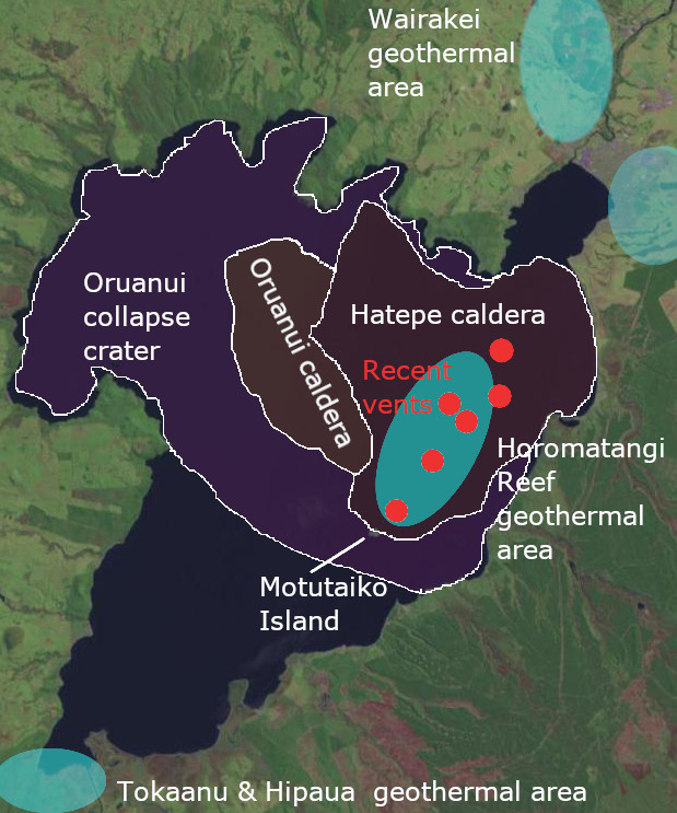
Horomatangi Reef
Within Lake Taupo there is one region where the lake is only a few meters deep. It is shallow enough that a shipping warning light was deemed necessary, and this was conveniently placed on a platform installed to measure inflation of the lake bottom. This region is the Horomatangi reef. It is located next to the deepest part of the lake, and close to Motutaiko Island, the only island in Lake Taupo. The reef comes from volcanic eruptions. So does Motutaiko Island. (The name is in error, as ‘Motu’ already means ‘island’.) The reef was formed in the eruptions 30 years after the VEI-7 eruption, 1800 years ago. The island may be older: I have not found a date for it. The reef remains an active region: it is the location of geothermal activity, and magma may still be accumulating here. It is the most likely location of a future eruption.
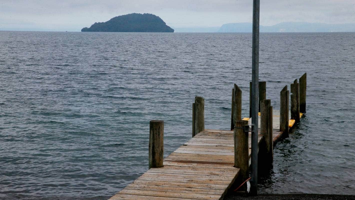
Motutaiko Island. Source https://www.stuff.co.nz/travel/destinations/nz/taupo/300172997/the-sacred-island-in-the-middle-of-lake-taup
Ups and Downs
Peter Otway and collaborators have been carrying out measurements of accurate levels around the lake since 1979, using 22 separate stations. They were the team who installed a platform on the Horomatangi Reef. The results show patterns where uplift and subsidence alternate in different areas. The plot below, taken from their paper, shows the location of the instruments and the change in levels over different time periods. It should be noted that the plots interpolate from the measurements: don’t look too hard for patterns where there were no instruments, such as in the centre of the lake!
The instruments first detected a pattern in March 1983, where Kinloch had started to rise, with lower rates of inflation on a line towards Taupo. At the same time, there was slight deflation on the southern side of the lake. By 13 June, Kinloch had risen by 47 mm. Three days later, the earthquake swarm started and unrest had begun. The swarm migrated southeastward. On 23 June, the Kaiapo fault ruptured. Now, Kinloch quickly deflated by 40 mm, followed by a slow further subsidence. By January, it has returned to its previous level. But on the east side of Kaiapo, the inflation continued and reached 55 mm by January. Plots b and c show the pattern over this time, before and after the rupture.

Clearly, over the 40 years there were a lot of ups and downs. By eye, it is already visible that most of the uplift is on the eastern side of the lake. That is confirmed when looking over the entire period. This is in the plot below, taken from the same paper. Kinloch is down, Horomatangi is up. The highest uplift is 135 mm, amounting to about 3 mm per year. The circles indicate where the measurements were taken and where the data is reliable.

The results clearly show that the area of the Horomatangi reef is inflating. This is on the eastern edge of the deep crater of the VEI-8 eruption and near the centre of the more recent VEI-7 eruption. The inflation is seen also on the eastern shore line.


The lines above show measurements along the north shore of Lake Taupo, crossing the various faults. Over the time, the west side of Kaiapo fault has remained at around the original level. On the east side there has been notable inflation.
This pattern agrees with the picture of average inflation across the area. It also explains why the Kaiapo fault is the most active here: it is located on the edge of the inflating region, so is subject to vertical strain. It is a tectonic response to a nearby magmatic intrusion.
The reef has been inflating for at least 50 years, but probably much longer. Around Lake Taupo are remnants of old shore lines. At Whakaipo Bay and Kinloch, these show that over the past 1800 years, there has been no net change in these regions. But at Rangatiro Point and Mine Point, near Horomatangi Reef, they show 5 to 8 meters uplift since the eruption 1800 years ago. That gives an average rate of inflation in this area of 2 to 3 mm/year – very similar to what was found by Peter Otway.
This inflation occurs in bursts lasting 1 to 4 years: these are the unrest periods. The inflation starts quite suddenly (within weeks) and also end suddenly. They are followed by a quiet period where there is a slight subsidence. In most places along the lake, the subsidence and inflation cancel out, but on the east side the inflation becomes permanent.
What is causing the inflation? The constant rate over a long period (with decade-long fluctuations) suggests magma intrusion is to blame. Assuming a 10 by 10 km region inflating at 3 mm/yr, about 0.5 km3 has accumulated since the eruption 1800 years ago. That is enough for a small eruption but not for anything on the scale of a typical major Taupo eruption. So where do those get their power from? The answer may lie in the Taupo rift. It is a subsiding graben, but around Taupo this subsidence is somehow being compensated. If we assume a 100-km long rift zone, 10 km deep and rifting at 1 cm/yr, then over 1000 years it requires an amount of 10 km3 of magma to fill the gap and compensate the rift subsidence. That is closer to what we need, although it probably overstates things since even Taupo does not do VEI-7’s every few thousand years.
Where does the magma come from? The caldera is rhyolitic, and so it is in storage and, like a fine wine, kept for ageing to bring out the best aroma. (Ok, volcanoes are not know for fine aromas.)

James Muirhead and collaborartors present the picture shown here. Underneath Taupo is a rift pillow where the mantle feeds the region. Above that is a zone with a partial melt of 10-20% which acts as a buffer. Above that is a mush zone which stores the (eventual) eruptible magma. The Horomatangi reef could be fed by a flow from this mush region to depths of a few km. The mush zone pulls in magma from a wider range of the Taupo rift. The volume of the mush zone is estimated at 250 km3.
What does this mean for us? The unrest episodes are driven by very small amounts of magma arriving at the shallow storage underneath the reef. The VUI scale is correct at not assigning these levels above VEI-3, and they are unlikely to lead to an eruption. (If they do, it would be a small event although probably with a spectacular view from Taupo.)
For a significant eruption, a much larger influx of magma would be needed. We have never seen the run-up a major eruption so have no idea how quickly that can happen. In the case of Krakatau (a very different system), there was a small eruption 200 years before the big one, and probably significant changes on the island in the century before the event, as we have discussed elsewhere. So we can suspect that we will have a century of warning. For now, it is important that studies such as those described here are continued. They may be our best early warning system.
Eruption
To end this post, I reproduce a story from Lawrence Cussen, district surveyor in the 1880’s. It was published in 1897.
I am indebted to Major Scannell for the following interesting narrative of the sudden rise and fall of the water at the north end of the lake on or about 28th August, 1883. On the day mentioned, a little schooner, which used to ply across the lake, was lying afloat at Tapuaeharuru. Some men working close by noticed that the schooner was suddenly left high and dry. They went to shove her afloat again, and in doing so they noticed that the river had fallen about 2ft. In the course of fifteen or twenty minutes it rose again to its previous level. This phenomenon was noticed by four or five people. It occurred at half-past twelve o’clock in the day. On that same afternoon, between one and two o’clock, Sergeant-Major Smith and Sergeant Miles, of the Armed Constabulary Force, were bathing in a warm spring called Waiariki, situated on the bank of the Waikato River, about a mile from the lake; the bath was fenced round with stones on the side next the river, and it stood about 2ft. above the level of the water. They found their bath become suddenly cold, and were astonished to find that the river had risen to a level with it. It remained so for about five minutes, and then suddenly resumed its former condition. So far as I have been able to learn, this was the only occasion on which the phenomenon occurred.
The event that the major described was not associated with a period of Taupo unrest – Lake Taupo was sleeping at this time. It was instead due to a distant, volcanic event, not even in New Zealand. That event was the explosion of Krakatau on that day. Lake Taupo responded to the atmospheric pressure wave. I am not aware how Lake Taupo responded to the dramatic eruption of Hunga Tonga this year.
Albert, August 2022
Sources:
- Taupō volcano’s restless nature revealed by 42 years of deformation surveys, 1979–2021. Peter M. Otway, Finnigan Illsley-Kemp & Eleanor R. H. Mestel, 2022, New Zealand Journal of Geology and Geophysics, DOI: 10.1080/00288306.2022.2089170. https://www.tandfonline.com/doi/full/10.1080/00288306.2022.2089170
- Introducing the Volcanic Unrest Index (VUI): a tool to quantify and communicate the intensity of volcanic unrest. Sarah Potter et al. (2015) Bull Volcanol. https://link.springer.com/article/10.1007/s00445-015-0957-4
- A catalogue of caldera unrest at Taupo Volcanic Centre, New Zealand, using the Volcanic Unrest Index (VUI). Sally H. Potter et al., Bull Volcanol (2015) 77: 78 https://link.springer.com/article/10.1007/s00445-015-0956-5
- Stretching, Shaking, Inflating: Volcanic-Tectonic Interactions at a Rifting Silicic Caldera. James Muirhead et al. (2022) Front. Earth Sci. https://doi.org/10.3389/feart.2022.83584
- https://nzetc.victoria.ac.nz/tm/scholarly/tei-Stout67-t21-back-d1-d3.html


Thanks for the article!
(+ do under no circumstances look at Fagra’s tremor graph.)
what is web link to faf.gif? thanks
You can find that one and many others nearby, here:
http://skjalfti-tremor.com/tremor-fagradalsfjall.html
Never realised Taupo had that sort of magma flux, that is almost bordering on mantle plume territory. I like to think of the calderas of New Zealand, and maybe also those of East Africa, as very evolved rift volcanoes. Fundamentally they are basaltic, with large heat flux and probably at times large scale intrusions, but rhyolite is less dense andnot easily mixed with basalt so floats and will erupt first. There are some basaltic eruptions from Taupo. Okataina has much more basaltic volcanism, 1886 being the main case but at least one other similar fissure, and the 1306 eruption was also a large intrusion with many maar craters beyond the rhyolite vents.
The scale of some of the ignimbrites from Taupo and the other calderas is vast. It is like the lid of the chamber just fell in and the entire chamber ended up on the surface. Freed from pressure the magma expanded and pushed sideways at high speed under gravity, not so much a lateral explosion but a glowing landslide with no friction. One if the ignimbrites a million years ago reached the coasts on both sides of the island and as far north as Auckland… This is one place I think we are better off not seeing the full fury. Even other VEI 7-8s done seem to be nearly so extreme.
Everyone hail the Kidnappers ignimbrite and despair!
What was the volume of that eruption? Insane really
2760 km3 according to the VOGRIPA catalogue. The Kidnappers Ignimbrite was briefly followed by the 1495 km3 Rocky Hill Ignimbrite. I’m not sure if they should be considered separate events or part of the same eruptive sequence.
Please tell me that was tephra and not DRE …
And there was a separate but close VEI-7 following the Kidnappers eruption, right? 200km cubed I think.
Yes, it is bulk volume, not DRE. I don’t know many details about Mangakino caldera but VOGRIPA lists four large eruptions from Mangakino within a 60,000-year period. Kidnappers ignimbrite with 2760 km3, Rocky Hill at 1495 km3, Unit E with 300 km3, and Marshall at 115 km3.
It seems like the TVZ calderas spend a long time building up to a big eruption and then do several in relatively short succession. Then there is a long gap at that location but somewhere else takes up and oes big. It might be notable the TVZ currenty has two active caldera systems where it often has only had one,not sure if that means each is half as powerful or if the zone has increased in priductivity though, it might be unimportant in the long run…
Far as I can tall Mangakino was followed by the Whakamaru calderas, a bit north of Taupo, with 4 VEI 8s in 100,000 years. Then after 200,000 years there Kapenga volcano grew, to its north. I dont think it ever did a VEI 8, but there were several other volcanoes that only ever did one big eruption that went off around the same time after 0.5 mya, all of which were still mid-high VEI 7, probably still enough to count as a supereruption in scale. Okataina and Taupo are both still young, under 100,000 years, and Okataina has not done a supereruption yet….
So maybe activity is not so dramatic now as some past times but the system is far from declining and might have another surge in the near future.
Tremor at faf seems to be bouncing up again, is something afoot?
Not in the way you’d expect it for the eruption to start up again.
While I am quite an avid volcano enthusiast and enjoy learning more about different kinds of volcanoes around the world, and reading many articles on this site as well, I’m not a volcanologist and can’t really take in all the intricacies of chemical compositions etc. Instead, when exploring the topic, I must count more on general geography, and things that are easy to be identified based on maps/satellite images.
So now that the disclaimer is done, the location of Taupo has intrigued me for a long time. Apart from Ruapehu/Tongariro (and the peculiarly located Egmont), Taupo seems to be really at the southern end of the Kermadec Trench. South from this region, there seems to be no volcanic activity (at least recent), even though some quite fierce earthquake activity exists (such as the Christchurch one some years ago).
To me, this implies that Taupo may act as a reliever of much more volcanic “pressure” than would normally be present at that location, also taking in magma from much further south than usual. This might explain the high magma inflow rate, and frequent and powerful eruptions in the geological now.
(Or not, but it’s fun to speculate when you’re not an expert 🙂 )
You are very welcome! Taupo is worth another post. It seems as if the area can’t decide whether it wants to be a rift or a volcanic arc
Is it the fact that dry land exists in this area that the volcanism has become rhyolitic / explosive (the thicker crust allowing a cap that helps the magma evolve and become explosive, as opposed to just being an effusive oceanic rift)?
This was such a great and interesting article Albert, I love when you tackle large scale stuff. Frankly, I love everything you write.
I look forward to the next article you write involving past geologic eras, ancient tectonics and the supercontinent cycle, and basically anything along the lines of your ‘Ghosts of Christmas Past’ or ‘Ice Age’ articles. Those have long been my absolute favorite on the site.
Just absolutely enthralling.
Thank you. It seems to me that VEI-8 eruptions only occur underneath continental crust. Presumably that is because you need a thick crust to contain the magma chamber. Some extension in the crust is also needed to reduce the stress and allow the magma chamber to expand sideways, but not too much as it weakens the crust. You do not need particularly high magma supply rates.
Toba is a good example: it is in a volcanic arc grown above old continental crust, with a bit of extension because of the bend in the subduction axis. It is perfect. The other islands of Indonesia are the same volcanic arc but sitting on oceanic crust. They do VEI-7 eruptions (lots of them) but not VEI-8. Those regions will have the same magma supply rate but are unable to contain the magma for long enough.
Albert that’s a very interesting and important point, re “You do not need particularly high magma supply rates.”
I think when one begins learning about volcanism and the enormous scale of VEI 8 events, it’s easy to think / assume that such volcanoes have an enormous supply rate of magma. After all, they end up erupting orders of magnitude larger than anything else on the planet so it’s easy to think part of it comes down to having a similarly large magma source.
It’s more about the setting and the ability of the location to support a large magma chamber and keep it evolving / growing long enough to go VEI 8.
Interesting, thank you.
Might be some truth to that, although unless I misremember high silicic composition is quite common in the Kermadec arc although large calderas aren’t common.
Great article on Taupo Albert. Really informative on how we might expect a big eruption there, which I clearly doubt we’ll have in our lifetimes.
Are we going to see a super eruption in our lifetime? Or are the time past on vei 8 eruption? Has the earth cooled down. And cant deliver so strong eruption?
Um… I’d say no to both. Large volcanic eruptions like this are (usually) Rhyolite, which is (generally) the coolest type of magma. They’re very much still possible. However, the odds of us seeing one are extraordinarily small. It takes an incredibly long time to build up a magma reservoir that large, to the point where I think the average time between is something like 100,000 years. They’re exceptionally rare events.
We have published a few posts on this. See https://www.volcanocafe.org/ten-volcanoes-with-super-eruption-potential-part-i/ and its follow-up posts, and https://www.volcanocafe.org/power-of-the-past-25-super-eruptions/ and its second part
“Super” eruptions aren’t exceptionally rare, There have been 4 in the past 100,000 years which gives this year 1 in 25,000 chance of seeing a great eruption which still isn’t something to lose sleep over.
However, a VEI-7 recurring something like 1-4x per thousand years (if you include the near 7 events, like 6.8 / 6.9 etc ) is much more possible to see in a single human lifetime.
Still unlikely, but damn sure not as a rare as a proper supereruption.
I’ll be happy to see an event larger than HTHH in the remainder of my lifetime.
I was a toddler for Pinatubo so I only get to experience it retrospectively. And HTHH, as spectacular and fascinating as it was, ended up being exceptionally brief for an eruption that size (speaks to how bonkers explosive and powerful it was).
…and you must have coasted through the winters of the several years that followed Pinatubo.
Actually, most rhyolitic calderas require a massive heat flux to keep them active. In most cases this is from an even more voluminous basaltic system that is under the rhyolite, in the case of Yellowstone there is over 11000 km3 of basaltic magma underneath its rhyolite. This is the case in the TVZ too, where both Taupo and Okataina have had basaltic eruptions. Rhyolite has a high heat capacity, so it is probably only erupting at the temperatures it does because the deeper source is not actually capable of heating it more. Supervolcanoes only seem to erupt crystal poor rhyolite, which is much hotter, so their heat sources must be extraordinary. It is probably not coincidence that the biggest ignimbrites were erupted in close proximity to basaltic LIP provinces.
The other way they form is above a batholith, which is what happens in the Andes. That seems to be more driven by hydration melting than extreme heating and the granite is probably not really a liquid magma, but having a continent scale body of granite will lead to some of it managing to escape… 🙂
The TVZ is both, it is a continental rift with a massive heat source, and it is near a subduction zone so you get a lot of extra volatiles. That might be why some of the eruptions here are so big, even among VEI 8 scale volcanoes these ones have a huge blast radius.
New Zealand’s major rhyolitic eruptions produce magma that had been stored at perhaps 800 C (so cool) but with reheating prior to the eruption. The heat flux is not permanent: the rhyolite get reheated episodically. That seems to be a trend in major eruptions, and it seems plausible that they start off with a new batch of rising magma reheating part of an existing reservoir.
Wait, didn’t the La Garita caldera in the Fish Canyon tuff erupt dacite, which is a bit lower of a silica content than rhyolite?
A lot of dacite is rhyolite with crystals of a lower SiO2 content, so it is equalled out to a magma with a dacite composition but is really something else. Rhyolite with crystals of intermediate or mafic composition for example.
This sometimes even goes to extremes, Shevluch erupts basaltic andesite, but it really is erupting a felsic magma that has not yet lost its load of mafic crystals.
But also dacites are only slightly less silicic than rhyolites, and the composition of the crust matters too. Much of the magma in these volcanoes comes from melting crust, especially if the volcanism is intraplate because that is often very hot. Maybe La Garita was in a part where the crust was not so silicic.
Chad, similarly didn’t you say in a recent article that Komatiite is similar to Picrite Basalt with lots of olivine crystals? Basically it formed at a lower temperature than needed to form Komatiite.
So TAS classification is the % averaged out through the entire sample, crystals / inclusions and all.
Yes, picrite basalt as a whole rock composition is basically the same as komatiite. If you completely melted a picrite it would be ultramafic. But it is still basically normal basalt that has just picked up a bunch of olivine crystals.
There is one very interesting case though, not particularly well known where a possibly borderline true ultramafic lava erupted in living memory. Episode 4 of the 1959 eruption of Kilauea Iki began strangely, where the original vent clogged and a new vent opened above it. The lava from this was described as blindingly bright white as opposed to typical light orange and was observed to be extremely fluid. It was measured over 1200 C with an optical pyrometer, so was maybe close to 1300 C,or even 1400 C in the interior if the fountain. This was only quite brief a few hours, the eruption soon began fountaining much more again and other readings from that episode as well as other episodes of the 1959 and 1960 activity were within standard values, but this one sequence has always stood out to me since I first learned of it. Far as I know only one picture of it exists and only a few people ever saw it, as it was at night. Those few, however, were experienced volcanologists…
Eventually there will be another super eruption. I don’t think there will never stop being super eruptions unless in the future humans become capable of Geo-engineering volcanoes. The issue is the rarity, it makes the odds extremely low for us to live a VEI 8 ourselves. The only likely chance is if we figure out how to extend our lives for tens of thousands if not Hundreds of thousands of years which is even less likely. But really who’d want to live through such an event, it may end our lives in extremely horrific ways.
ever not never I mean.
If we ever find a way to live for ten thousand years, we’re all but guaranteed to witness some absolutely mind boggling eruptions even if not proper super eruptions.
Think about all of the major events in the Holocene, from the mini floods in Iceland to all of the VEI-7
s and high VEI-6’s.
Espbau: I think that the earth still has lots more VEI 8’s in store……probably thousands of them. The earths mantle is cooling at a rate of about 1 C every 10 million years. At this rate the mantle would be about 100 degrees cooler in a billion years and that might be enough to greatly reduce volcanism. If we made the crude approximation that earth produces about 1 VEI 8 every 100,000 years, and the average rate of these declines exponentially by one percent for every degree the earth cools that would imply that in 1 billion years the rate of VEI 8’s would be 1 per ~270,000 years instead of the 1 per 100,000 years that it is now. In that scenario the earth would produce about another 10,000 VEI 8 eruptions before it becomes too cool.
One has to consider that the Toba eruption was several times larger than a minimal VEI 8 and occurred only 74,000 years ago, when the mantle was only about 0.0074 degrees warmer than it is now. If the earth can still produce an eruption so much bigger than a minimal VEI 8 one might expect that it would have to cool substantially more than it has up to now….probably by tens of degrees and that would take hundreds of millions of years
Dont forget that is only the average upper mantle too, there are some places like Hawaii where the upper mantle today is as hot as Archean upper mantle was. The highest temperatures for Hawaiian basalts apparently are the hottest lavas erupted in the Cenozoic and might even be among the highest since complex life evolved. Our planet is never going to go extinct, it will be destroyed by the Sun far sooner.
In 2 billlon years the astenosphere will have dropped perhaps 200 C and that Maybe enough to kill it as a thermal phenomena stopping plate tectonics
But Earths interior will still remain very hot as its a relativly large rocky object. Earth will probaly become more venusian in geology with mantle plumes resposible for volcanism when plate tectonics slows down.
But already in 1 billion years the Sun will be 10% brigther and Earth Maybe very uninhabitable by then, infact Earths best years with the sun are already over
Earths best years with habitablity may have been in devonian, early carboniferous, or late jurassic/ or the Cretaceous Seemed ideal
Future similar greenhouse eras will be very bad .. combined with a ever brigther sun.
Taupo in dreamland, where it’d be nice if it stayed. That said, I *would* be interested in seeing a new article analyzing the other caldera systems in the region. Mostly Okataina, it is distinctly the most threatening one, but the others are very interesting as well.
Okataina probably has a much higher risk of doing something huge, still a low risk of a caldera collapse but even normal eruptions there are massive. Tarawera reactivated in 1306, it was otherwise only active in the Pleistocene, and because of that probably all the eruptable rhyolite went up in 1306 and future eruptions there might be more like the 1886 eruption, explosive basaltic.
But the Haroharo volcano next door, that one is a monster. Its last eruption was also a basaltic eruption, a radial vent near Rotorua, but otherwise it has been rhyolitic and likely still has large volumes of it in an active chamber. The Whakatane eruptive series about 5600 years ago was the last major event from Haroharo, and is a rare example of a large scale rhyolitic rifting fissure eruption. It was as big as Laki, 12 km3 of magma that began with a VEI 5 plinian eruption followed by several years of lava flows, and several equally big eruptions have occurred there before in the same manner. Haroharo is probably where the next TVZ caldera will happen, and it might end up being a bimodal rhyolite/basalt ignimbrite if Tarawrera also gets consumed. Not sure if it is big enough to reach VEI 8 but then that might not really be important at those scales…
Taupo just did a VEI 7 I would not expect it to do anything crazy for millennia, although even a relatively small eruption at a volcano of this calibre is probably still a VEI 4-5 so best not be on the lake when it happens… 🙂
What makes you infer that all of Okaitana’s rhyolitic magma erupted in 1306? Just curious as to the rationale.
Is it possible 1886 was a large basaltic intrusion that bypassed or otherwise “missed” the system’s silicic storage, especially considering this is a large and spread out volcanic system?
Just curious. I’ve heard the same regarding Vesuvius (that it blew out all its phonolites in 1631), and for sure Vesuvius and Okaitana are vastly different, but I’m just wondering how we can come to that conclusion.
The idea the 1886 eruption bypassed the rhyolite is the common idea. But that just doesnt really sound right, the rhyolite is at the top of the system, and it sounds very unlikely that such a big volume of magma would originate somewhere not within the caldera.
The other reason is that back in the Pleistocene Tarawera was constructed out of massive rhyolitic mostly effusive eruptions. Then it went quiet and Haroharo began its largest growth stage in a very similar fashion, up until a couple thousand years ago. Then was construction of Edgecumbe, which is a dacitic lava dome volcano north of Okataina, which might be better considered a distal satellite, maybe only joined at depth
The Kaharoa eruption of 1306 was the reactivation of Tarawera, and it behaved mostly the same as previous episodes except that the volume of lava was a lot less compared to the explosive initial stage and built up steep domes rather than flows, the magma was old and stale. Not only that but there is a line of maar craters that goes for many km to the south tracing the path of a large dike, a huge basaltic intrusion pushed out the rhyolite. Then, in 1886 the same thing happened almost exactly, even on the same rift line, but only basalt erupted. There is also some evidence that basalt dikes were associated with the construction of Tarawera, and the last eruption from Haroharo was a basaltic radial vent at Rotokawau, which is a maar crater near Rotorua. The TVZ is volumetrically 90% rhyolite but that is a misleading number, the rhyolite eruptions are always big, but the basaltic eruptions are not always, and even large ones are not much compared. But by number these may be more common.
So there is no actual confirmed reason, but the evidence to me is better explained by there just not being any active rhyolite under Tarawera today.
Makes good sense Chad, thank you for the in depth overview of the system.
So talks of Okaitana having super eruption (or near enough) potential are certainly not referring to anytime geologically soon? Would take quite a while to re-grow a VEI 7 + silicic chamber. Or are there multiple chambers at a different stop in its series?
The situation of Tarawera not having any rhyolite left might be very local, the rest of the caldera seems to be different. The next caldera there might just be more west or north.
According to this explanation Askja should not have been able to do its rhyolitic eruption of 1875. It´s a frequent basalt eruptor, and suddenly goes all rhyolite-crazy with a VEI5? There has to be a way for basalt to bypass rhyolitic pockets and layers, I wouldn´t say there can´t be any rhyolite in Okataina!
I didnt say it isnt possible for basalt to bypass, just that it is not what I think is the best explanation. Also Askja erupted from its ring fault with basalt, and the rhyolite in 1875 was from an intra-caldera vent that later collapsed itself. I also have seen that more recent numbers show the rhyolite was a minor component volumetrically and the collapse was a result of magma withdrawl to feed the distal rift, so badically like Holuhraun except there was some shallow liquid magma in the caldera. Very different to Okataina.
If Okataina does a future caldera, I think it would be more to the northwest of the existing caldera, centered on Haroharo.
The fact actually that this area has not erupted now for millennia might mean that is the next course of action.
Another case of basalt bypassing a rhyolite magma chamber is the Krafla Fires. Krafla is known to have a chamber of molten rhyolite that was accidentally drilled into while seeking to produce geothermal energy. And yet Krafla always seems to erupt basalt.
The 1875 rhyolite eruption of Askja was ring dike fed, probably. Earlier and later basaltic eruptions came from cone sheet intrusions and normal dikes.
I wonder if rhyolite melt is so viscous that a basalt dike can break through it as if it was solid rock. Or maybe the dike can start from a lower basaltic melt storage and simply go around the rhyolite.
I dont know about it being too viscous, a lot of rhyolite flows look pretty mobile, actually they often look less viscous than a lot of less silicic magmas. The 1960 flows of Puyehue-Cordon Caulle look almost like sticky basalts but are glassy rhyolite. Lots of the trachytic volcanoes in East Africa also have what looks like quite low viscosity magma, like at Longoknot or Menegai. Then there is Bora Ale which is peralkaline rhyolite and yet looks visually very similar to Etna, only the lava is not black.
Apparently rhyolite is not easy to mix with basalt even if they are both fluid, so hot rhyolite would be like oil on water. In the case of Askja also the DRE of the summit eruption was a mid VEI 4, about 0.4 km3, not a VEI 5 like assumed. The caldera was created by lateral draining to feed the massive rift to the north which let the rhyolite decompress but there was not a large volume of it. The rift only erupted about 0.5 km3 of lava, and in many eruptions over a year, it was not intense, but the length of the dike is some 70 km and probably contains several km3 of magma. The VEI 5 estimate was based on assumption the caldera was created by the 1875 plinian eruption but it took much longer and many decades to collapse, only stopping when more magma arrived in the late 1910s which lead to more eruptions in the 1920s.
@Hector wouldn´t be surprised if that´s the case! Erupted rhyolite is usually re-heated after all, so it is logic that rhyolite can form flows on the surface. Basalt won´t re-heat the rhyolite just by flowing around rhyolite-pockets, the basalt will probably dyke right through the “cold” and stale crystal-mush. Once the re-heating started, it is a run-away reaction where more and more heat is distributed through the rhyolite pocket, creating a mess in the system that was balanced before and constantly increasing probably pressure until somehting shows on the surface!
Only time will tell when volcanologists get to observe how basaltic eruptions in rhyolite systems work in more detail.
Would be interesting to see if the path of least resistance is through the rhyolite or through the rock around it. Would probably need a lot of close monitoring how a basaltic intrusion heading to the surface behaves under those circumstances.
We have not see this in a while. The best fit for a event to associate this with is,
2022-08-20 23:07:41
Earthquake
Magnitude:1.8M
Depth:19.6mi
I choose the 48 hour, and Dand since it (and Wood does not) shows some other activity. It is the last tremor like instance on the plot. This does show on many other instruments.
The tremor is deep, seen island-wide. Probably from Pahala. But it doesn’t have the sudden onset of typical Pahala tremors, so HVO hasn’t located it.
The Pahala swarming is evolving. The swarm shows a gradual decline since late 2021, and is down to less than half of the strength it had in 2021. However, several kilometres to the south offshore of Pahala, a new weak swarm has shown up. The earthquakes are about 36 km deep and have been swarming during July and August, likely some king of magma movement has set them off, I think. This small swarm is along a line of earthquake activity that extends SW of the deep tremor locus of Pahala, where the tremor outburst of early 2019 happened, that probably set off the whole thing. The line has seen some enhanced activity since the Pahala crisis started in 2019. In particular there have been two sizable earthquakes, a M 4.7 in 2020, and a M 6.2 in 2021.
Another area that has shown a slight intensification through the past two years is a NE-SW oriented band of shallow ~30 km earthquakes just offshore Pahala. Meanwhile the onshore swarm which has seen most earthquake activity since 2019 is slowly waning. Earthquakes shallower than 33 km around Pahala:
I’m not sure if we will ever know what is going on under Pahala. Some kind of deep intrusive activity. But other than that I cannot say.
They look like sills forming, spreading out in the general area between the volcanoes. I havent seen any real evidence they connect to Mauna Loa, there is a hard gap and deep quakes seem very rare under Mauna Loa perhaps because of its age. The crust under Kilauea abd Loihi should also be a lot thinner too, Mauna Loa has its LP quakes at 40+ km while Kilauea is in the 10-20 km range, presumably showing the bottom of the crust is much shallower there. Pahala intrusions probably are happening in the bottom of the crust which may be why the quakes in general follow a line roughly along the trace of the south coadt and then up inland under Kilaueas summit and north from there somewhat. Quakes of the same depth as Pahala are common under both Kilauea and Loihi, not as dense as the swarm itself but there is clearly some structure which could allow for a connection. It doesnt look like that connection into the magma system of Kilauea actually exists at present though, unlike what I thought before, but if this model plays out it is likely something will happen eventually.
Still, a large volume if extra magma in a place like this is not something to ignore. If it does erupt on land it could be pretty serious.
Wow , great post Albert. I enjoyed reading it and great detail. Something to take my mind off upcoming gas and electric bills too
If you want an up-to-the-minute eruption and explosion, hook into one of Taupo’s trout.
Not totally finished yet. There were a couple of episodes of small lava emissions over night.
Here’s one:
Source: https://www.youtube.com/watch?v=ihTaTv-24aU
More like a funeral for a friend as remaining lava finds its final resting place.
How come that folks are so sure the eruption episode is over? Last year e.g. we observed an oscillatory phase following the steady initial phase. We also had longer intervals of no activity.
Probably because the tremor dropped off a cliff.
If this episode is over, there’ll be more soon, given the estimated volume of magma under the area.
The Icelandic authorities are waiting to see what happens before declaring this over or not.
Reykjavik Grapevine is reporting that geoscientists don’t believe that this is the end of eruptive activity in Meradalur.
https://grapevine.is/news/2022/08/22/volcanic-eruption-first-of-many/
The thing with last year’s eruption is that it was very rare. The eruption showed many unconventional behaviours that are not typical of most fissure eruptions. The dike for example growing continuously for ~3 weeks before erupting, when usually dikes take hours or days to erupt. Eruption rates which increased instead of decreasing, when normally rates will drop exponentially and die off. The gusher events which likely reflected erosion and maturing of the conduit, gusher events have been reported only twice in history as far as I know, the other instance being Surtsey. And finally episodic activity, on and off, which reflected even more maturing of the conduit, a rare feat I can recall to only have been performed by two other fissure eruptions, the Mauna Ulu and Pu’u’o’o eruptions of Kilauea.
This eruption instead has behaved quite normally so far, which gives little reason to expect anything too exceptional.
Great article about Taupo, Albert. Thank you!
There is a bit of a new swarm starting up again, new fissures may be on the way 🙂
A beautiful yet melancholy poem.
Very much a fan of the VUI by the way, is that being put into wider use?
The rest of the poem is even more melancholic, and gives the impression that the poet was not a happy chap. But it is like songs: we enjoy happy songs most, but listen most to the melancholic ones – on repeat. The VUI is the work of one group, and hasn’t really been used yet. It is different from the VEI in that that measures impact from the ejecta – so it doesn’t matter which volcano produces the tephra. The VEI scale involves many more aspects than the ejecta volume, but over time the other aspects have been left out and it now focusses on just one thing. The VUI scale tries to predict eruptions. That is different for each volcano, so adjustments are needed for each volcano. It may need a bit more work. But it seems worthwhile, and that was one reason to mention it in a post: it gives the scale some publicity.
Rift-graben situations don’t half supercharge volcanoes – the extension (and in this case subsidence) accommodating bigger magma chambers and higher pressure, so magma evolving and ageing until the lid can’t take anymore. On the west side Tongariro graben extends to the south-west end of the lake and the Ngakuru graben from the north-central part upwards. Taupo, Toba & Taal are of a similar ilk. Taupo more menacing arguably because of the frequency.
Following comments…
This is how large Mars is compared to the Earth: quite huge! While Mars because of its smaller mass, have cooled more than earth, its Impossible for souch a large object to have cooled competely yet. Mars probaly have still a hot active interior: Mars does have a very thick litosphere.. today because of its faster cooling.
That litosphere is likley very insulating
Mars is between Earth and the Moon in size so cooling rate should be too as well. Not Competely dead yet
But Mars is probaly in its very last days of possible volcanism as the litosphere have gotten very thick. Mars InSight revealed a 550 km thick litosphere so thick.
Honever the Tharisis Hotspot have been active for billions of years on same place so Maybe a possible pathway up there. Also the Elyseium lava megafloods are intresting
Mars have a few very very recent Looking lava flows, and that suggest the hot interior can still acess the surface.
Whats the core temperatures of Mars
I often put it at around 2800 to 3000 C
Earth is more massive and is hotter
Could be set off by impact events? Hard to understand how volcanism could ‘restart’ in that setting.
You needs to Re – melt the whole planet for that, and it wont happen today
But Mars is large enough to have an internal heat store, just not as much as Earths internal heat store.
Some marsian mantle basalt meteorites formed at 1550 C only 300 million years ago so the planet likley retains supprisingly ammounts of internal heat today. Marsian volcanoes form over long lived fixed hotspots and with No plate tectonics it Maybe possible for it to get through a 500 kilometers thick litosphere
Olympus Mons very likley haves huge magma chambers sitting at 160 to 200 kilometers depth
Something I wonder with regards to this though (that I’m sure is resolved easily enough, but…maths): Mars’ interior is cooler because the planet is smaller, meaning less insulation, meaning less magma. However, with a smaller planet surely comes reduced pressure, which means that lower temperatures are required for a liquid-phase mantle, while reduced pressure also means any magma would have an easier time rising upwards? Thus, perhaps there is still scope for more “traditional” activity – or, the reduction in pressure is insufficient to counter the reduction in temperature. Would be interested to hear where this balance actually lies!
When will the Iceland activity resume?
If the general recent trend holds, there will probably be another intrusion somewhere in November, they are about every 3 months or so since the end of the first Geldingadalir eruption, probably because the supply rate of magma to this area is currently very high. If that intrusion is at Fagradalsfjall or somewhere along the active rift then I think it will most likely erupt, but if it is at Svartsengi (Thorbjorn) then it is a lot less certain at least in the near term, although longer term an eruption there is a near certainty and being in Grindavik when that happens is not recommended…
But then the GPS shows the recent eruption hasnt relieved any pressure apparently so it might be much sooner before an eruption happens again, which would probably count as a part of the recent eruption rather than a new one.
If the pressure hasn’t been relieved, why did it pause?
The lava emission rate at c. 2 cubic metres per second was too low to support an eruption – there wasn’t enough energy. Lava may be still be flowing under the existing lava.
Suspect the dyke may have narrowed e.g. due to a blockage.
I dont know exactly, as Merlot says the eruption rate was too low at the vent, but the GPS and both of the major news sources are saying that the eruption didnt relieve pressure in the magma system as a whole unlike the intrusion that happened in December, so presumably whatever caused the eruption to stop now was a pretty shallow phenomenon and that it might not take much or very long for a new vent to open or for the existing one to reopen. Still could be some weeks away but I would be surprised personally if there is not another eruption before the end of the year, even before October is a pretty good bet.
The Krysuvik eruptions in the middle ages total probably about 0.3 km3, so could be as much as 3 km3 of magma per episode if the often quoted 10% rule is applied. I think that maybe is being too generous, and simplistic, but even half of that is as much magma as erupted at Holuhraun with a little extra. So we should expect there to be a lot of lava erupted by the end of this fires episode, some 10x what has been erupted so far, and it might take a decade to do it.
It also gets interesting because Svartsengi next door is also currently very active, and has had a lot of magma intrusions too. But it has not yet rifted so an eruption probably cant occur yet, probably because the rifting is happening at Fagradalsfjall instead. There was an intrusion in May into Svartsengi and there were several in 2020 and before March 2021, I think that would have been an eruption if it was at Fagradalsfjall. Presumably, when the rift at Fagradalsfjall is no longer active, then the risk of an eruption closer to Grindavik will greatly increase.
Krysuvik may be one to watch too. The seismic activity tended to start here and migrate westward.
True, but im not sure if it is actually magma moving so much like it is at the other two
They are now calling Geldingadalir and Meradalir the Fagradalsfjall Fires and expect more activity.
I acually think only 5% of the magma produced in Iceland erupts
Maybe at a deep level but I would expect the magma that gets into a volcano has a much higher ratio. Holuhraun was 1.5 km3, the caldera it created is about 1 km3 more again, so 1 km3 of magma in the dike.
It also seems onestly impossible that the volume of the intrusions feeding Laki was 20x the lava, and didnt create a caldera. Maybe 5% of the magma that is made in the mantle reaches the surface but that isnt the same as every eruption is only 5% of the magma in that event. If it was then why is it some 10x higher ratio in Hawaii and Galapagos, which are the same magma. As I can tell Iceland plume is actually a bit weaker than those two, and ridges are not productive along individual sections especially not slow ones which Iceland would be if it was not supercharged by the plume.
Iceland plume weaker than Galapagos?
I place it as same strenght .. or somewhat stronger
Althrough not in the Hawaii territory..
Hawaii is like an intense welding flame
While Iceland is like a large spread out wood fire
Galapagos seems to be a very powerful plume, it is not as strong as Hawaii, but like Hawaii it has constructed a massive structure on the ocean floor, and that seems to be without the help of an ocean ridge despite being close to one. Iceland combined is probably more productive than either Galapagos or Hawaii but it is spread out over a large area, and Vatnajokull on its own is nit nearly so productive as Kilauea for example. One only needs to look at Holuhraun and Ahu’aila’au, and how Bardarbunga is nowhere near erupting again but Kilauea is already filling its caldera. Galapagos is hard to compare to Hawaii because there is more than one active volcano, but Fernandina erupted from overpressure only a decade after a caldera collapse comparable to what Holuhraun caused…
A new Volcanic Activity Bulletin was issued for Taupo today; the seismicity continues at the same rate, but now a small deformation signal is also seen:
https://www.geonet.org.nz/vabs/3jzixUTzoMoxtANtEoPvKw
Activity but not warranting an alert. It fits with the post, I was happy to see!
Smug grin?
you’d have to ask geonet
I work there so not about to comment further!
We’ve changed the terminology. They all used to be ‘Volcanic Alert Bulletins’; they’re now all ‘Volcanic Activity Bulletins’ – because every ‘alert’ also reflects ‘activity’, but not every ‘activity’ reflects an ‘alert’!
A completely correct thing to do! And the word ‘bulletin’ rather than ‘notice’ makes the same point, I think. Whether the public gets this is a different matter. I hope you are enjoying your work!
And any corrections on the post will be gratefully received.
OT: Seems Youtube doesn’t like you taking screenshots with alt-printscreen. It will drop the framerate into “seconds per frame” territory and start randomly pausing and unpausing by itself. A full reload of the page doesn’t undo this. Do I have to delete a cookie or something to make it forget that I took a screenshot, or am I screwed, at least when logged into my gmail?
In two months my wife and I will be in Iceland and taking the trek to Fagradalsfjall! Would be wonderful to get to see an active eruption, though at this point I’ll settle for a fresh lava field. All the same, will be incredibly fascinating to see (capping off a nice hike out there).
If the eruption restarts, I keep envisioning we’ll run into Jesper there, only he’ll be surfing down a lava flow on a chromium surfboard in a volcano suit while taking samples and inspecting its viscosity / temperature.
Cowabunga dude!
Caught the movie “Fire of Love” at the local cinema-plex last evening. It’s about Katia and Maurice Krafft, french volcanologists who spent their adult lives investigating and filming eruptions together, and it includes loads of spectacular footage from their archives. Perhaps the film will show up at a movie theater near you. Here’s a link to a a balanced review, which includes a link to the film’s trailer:
https://www.abc.net.au/news/2022-08-26/fire-of-love-movie-review-volcanologist-couple-documentary/101352224
Good flick.
Been following the conversation here following Albert’s excellent post. I find that these two contributors to ‘Nature’ appear far more concerned than ya’ll seem to be.
https://www.nature.com/articles/d41586-022-02177-x?fbclid=IwAR0Rw5kkXad79YE9lk1hOkPLXpeocI6GIyCBYFPxs_pRJp2slwwijzJ9nuU
Taupo is not mentioned once in that document; it concerns global preparedness only.
Correct. However, the conversation herein did concern itself with the likelihood of VEI 7-8 eruptions
We have often discussed our lack of preparedness for major eruptions. It is not unique to volcanoes: governments go to great lengths to downplay risks in order not to spend money or inconvenience their major companies. Look at the current energy crisis to see this (the UK government had unwisely stopped a house insulation program and closed its gas storage), or just wonder how we managed to have 1 million covid deaths in the US alone, or how Hungary managed to fire its weather forecasters for predicting rain. Locally the volcano observatories do excellent work in safeguarding people, but they cannot protect against global impacts. We live precariously – how precariously will only be evident in hindsight. There is not much resilience in our economy. Is the peculiar weather this year in the northern hemisphere perhaps related to the water vapour injected into the stratosphere by Hunga Tonga? It has pushed China and parts of Europe into a crisis.
Mike though is correct that Taupo is not implicated. It is at low risk of erupting.
RE: Is the peculiar weather this year in the northern hemisphere perhaps related to the water vapour injected into the stratosphere by Hunga Tonga?
Albert, this is a tad off topic but since you cited water vapor, the U.S. State of California has passed legislation forbidding the use of ICE’s as of 2035. Only EV’s and ‘hydrogen’ fueled. If the by-product of hydrogen combustion is water, [as vapor] does it not then pose a risk factor, on a large scale, as concerning as carbon?
No. The amounts are miniscule. Just look at the numbers. The atmosphere contains 400 ppm CO2 (should be 270 – the difference is entirely due to us). It contains 40,000 ppm H2O. Adding the same amount of water as we did CO2 (which is effectively what would happen) makes no difference to the water in the atmosphere. Add to this the fact that water quickly drops out of the air (it is called ‘rain’ – perhaps a new experience in California) while CO2 spends centuries before dissolving into the ocean.
And compared to Hunga Tonga: that is about water injected into the stratosphere. Our cars don’t do that.
What you should be asking is where will California gets its electricity from by 2035? It certainly has the resources to do this from renewables but it will take a major investment program and a policy to build in resilience. That resilience must come from nuclear and fossil fuels. The latter sounds surprising but there is no objection to using fossil fuels for back-up as long as those are only needed rarely. It would be much harder to make this work in Texas because its electricity network is disconnected from the surrounding states and is therefore much more likely to fail under overload, as happened last year. But I think Texas is the only US state in that situation.
There is much development in battery storage. It is also proven to be incredibly effective, the Tesla battery packs deployed so far have all seen massive improvements in their local grids. There are also other battery technologies that are much more robust that are going to soon be in wide use, Li-ion is not well suited to this ut is just currently the cheapest option, but not the most cost effective.
Fossil fuels need to die if we are to stand a chance at the future we want, there is no room for them. Talk about conspiracies but we have all been lied to that they are the only option, renewables with storage is already cheaper and more reliable today, electric cars are too, every bit of the fossil economy is built on a web of lies and inefficiencies that no individual has the power to expose. Opinions can be had about Elon Musk, and Tesla, however that is largely in irrelevant point, that made electric vehicles actually attractive, and showed people they work and even ignoring the environment are just a better product… It is a global market change like that which is needed to drive the world. It might be illegal to mass produce ICE cars in 10 years but few people will actually want to buy one much sooner and a lot of people will not want their existing model especially when the price of fuel goes up more (it will necer go down again). I imagine a huge market will also exist for retrofitting old cars, turning them to EVs, which at least for a while may exceed all new EV sales combined.
Now all we need is a critical use for CO2, something that will make it valuble.
Some of the arguments against renewables actually come from the weaknesses of fossil fuels. Renewables fluctuate on all time scales. If this fluctuations go against you, even Musk battery backup won’t last long. There are some options. But most fossil fuels are very inflexible. You can’t just turn on a coal powered generator: it takes days. Nuclear power actually has the same problem. So the industry argues that coal should be used all the time. Imagine running your home that way. So no coal (sorry, Australia). Nuclear is best used as base load, with renewables taking the rest (the majority). Cars are well suited to this since you can charge them at the best time. They are in effect one of your storage solutions. Domestic heating and cooling is the biggest problem. It is a solvable problem. But no need to demonize fuels. If we can bring usage down by 90%, they are not too much of a problem. Except for coal – use of that should be illegal.
RE:”Except for coal – use of that should be illegal…”
The counter argument is that giants like China and India are not on board that train, likely not to be for quite come time, declarations notwithstanding, and that the United States and others committed to zero carbon are placing themselves at risk strategically, geopolitically and economically, particularly where China is concerned. Your conversations months ago in the matter of ICE vs EV were interesting and enlightening. However, where resources such as lithium are concerned, China appears to be in the proverbial driver’s seat potentially enjoying the best of both worlds.
I am afraid I don’t follow this argument at all. Why continue to use the dirtiest and least efficient fuel available, which actually kills people both in mining and from pollution, just because someone else does it? Have you seen the pollution in New Delhi or Beijing? (Beijing though has improved a lot since China shut down the coal stations near the capital.) China is also investing 50% more in renewables than the US does. That is one reason why it is so dominant in the production of solar panels. Not only has China boarded that train, it is the driver. The US may now take over, though, with the new plans.
RE:” Have you seen the pollution in New Delhi or Beijing? ”
Affirmative. We docked in Tianjin on 11/10/14 heading for Beijing. What I thought was a dense fog wasn’t. It was odiferous. Co-incidentally, the APEC-China was on from the 10-12. All the factories were ordered shut down and the restrictions on their driving lottery for those days increased. The air during that time was sweet. We left the day following the end of the conference and one’s nose could easily detect that all was back in order.
I was there in 2016. The smog was so bad it affected visibility inside the meeting room.
RE:”What you should be asking is where will California gets its electricity from by 2035? ”
Yes, I’ve questioned that, and elsewhere as well. Taking your comments regarding hydrogen a step further, for talking point, and projecting it as a mainstay fuel in future, how might that then affect the water cycle? Increased rainfall?
It will have no effect whatsoever. The clue is in the word ‘minuscule’. On the other hand, global warming is increasing the water content of the atmosphere because of higher evaporation. That does give a measurable impact. Hurricanes (which thankfully have refused to get going in this year’s strange weather) now produce perhaps 10% more rain than in the pre-warming days. (That number came from the one which flooded Houston 2 years ago.) Semi-arid places see drying as the climate zones shift, but in general rainfall is increasing as predicted. See https://theconversation.com/increases-in-rainfall-extremes-linked-to-global-warming-11933
Hydrogen emissions are not going to do any climate change, because the atmosphere is already saturated with water vapor. But hydrogen is a terrible idea for a complete replacement of our fossil fuel grid. For one, in most cars it has a lower energy density than a battery, because a tank capable of holding 700-800 bar of H2 is heavy and must be round, so takes up a lot of space. And unlike batteries which are not yet close to theoretical max performance, you cant make a H2 tank not be the way it is, unless you use solid storage which doesnt solve any of the dangers. It ironically is all of the problems that people used to use against EVs, that they are heavy and low range. But you can fill it up in 5 minutes… there is no way in any situation an untrained person would be allowed to operate a hose and connector that deals with a 800 bar pressure gradient and a gas that explodes in all concentrations with air if it lights… Industrial H2 use is performed by highly paid professionals who understand their risk. Even the 300 kW superchargers, which would probably also make you explode if you short circuited them with yourself, those are turned off and not live until they are in the car and will not turn on unless a good connection exists. F
or rapid charging of its electric Semi truck (and likely others elsewhere) Tesla is making 1 megawatt scale chargers, some say that will destabilise the grid, but if we want hydrogen everywhere either it needs to be made somewhere and transported (stupid idea) or it is made on site, and you would probably need a 1 megawatt electrolyzer to keep up with daily demand, at every station, if we do the H2 economy…
Hydrogen has much better numbers in larger vehicles, particularly for ships and planes, it isnt something useless, and these sectors will have fueling professionals to train… Long distance trucking and trains also give room, although the majority of trucking can be done easily by electric. Hydrogen also can run in a diesel engine, so at least it will not necessarily be required to replace all trucks immediately with one containing a fuel cell.
Will forever be cofused by Toyota. They built the Prius back in the 90s, before even the EV1 came out. And where General Motors decided to nuke the EV1 to what is probably now their doom, Toyota has still made millions of hybrids, I drive one of them. They know how to make EVs, but they didnt until this year, and their rollout was a total failure with a recall of every vehicle… They partnered with Tesla after the Model S was released, to put the Tesla drivetrain in Toyota vehicles, a decision that might have changed the world. But they abandoned it thinking Tesla were going to fie and no-one would want EVs and hydrogen was the future. That despite the electric grid being the only thing more widespread than fossil fuels and the amount of then-and-now H2 stations being in the hundred world wide… What they are doing, is basically the modern version of making motorized horse carriages after backing out of a personal deal with Henry Ford in 1908… And then saying we should feed the horses with expensive meals because they are more nutritious… If Toyota put their efforts towards trucking and large transport it could be one of the winners in the green economy but sticking with cars and trying to dethrone Elon Musk is going to be their downfall, its a race for pride they cant win, and dont even need to participate…
I’m really tired of pointing out it will be a decade or two before even most of the electricity in most countries is non-fossil generated. As a consequence replacing diesel cars for gas-powered EV is marginal at best even before you consider the cost of producing the EV and the extra powers stations required to power them.
Its an ecofreak politicogreen ‘solution’, looks great achieves little.
Better would be improving home insulation, possibly by demolition and modern construction because its really hard and expensive to add effectively 150mm of hi-grade insulation round all six faces of a house.
Enforcing (by drastic taxation) only small hyper-efficient small diesels (cheap to make and run) say 45HP max will reduce energy usage (most electric vehicles I see have very powerful engines). We also need to return to the old says when houses in winter might only be heated to maintain 16C rather than 20C or even 25C many seem to expect these days.
If energy costs, the first think to do is use LESS not subsidise it to use the same amount.
I fully agree with you. Energy usage has to go down, and it can. Any green solution requires energy efficiency. But if you want to be fully green electric in 20 years, then for instance new cars need to be fully electric in 10 years from now. That is about the trajectory we are on.
The answer to any future involving transport should not be to use more cars. But the second answer to that is never to use a combustion engine, the most efficient use of a diesel engine is as a generator to power an electric engine, where it can be optimised to run at 45% efficiency. But diesel cars will not get this, and they are closest when driven slowly, which you say. I would argue that anyone claiming to be an environmentalist and advocating for using diesel in any situation is the definition of hypocrisy, no offence to individuals, but that is just reality. There is much more to this than just CO2, but NOX, and particulates. Optimised diesel engines make less CO2, but dangerously high levels of the others, 1 in 5 people in the developed world die from exposure to these emissions. And tuning an engine to reduce this makes it far more inefficient. On elctric motors being powerful, there is not eve na comparison of efficiency. 100 kWh battery has the same usable energy as about 10 L of petroleum (be that octane or diesel) and yet you can drive a Tesla Model S 700 km. Try driving even a tiny diesel at low speed anywhere near that far, let alone on 10L… Electric motors have been understood as the superior product for over a century, it is the weight of the battery that has kept their use out of mass transport, and that is no longer a problem and will be even less so in the future.
Solar can be put on roofs, it will not take up any extra space at all that way. Batteries could be centrally located at sites of power stations, where any fear of fire or other hazard is not a problem. And most EVs can be used for vehicle to grid, far as I know only high end Teslas dont have the option but those are not high volume production. Tesla has optimised engineering for the cars, built fr m the ground up (finish is sometimes questionable, but if that is the worst issue anyone brings up I think that is a good direction to be in…) but until recently legacy auto had been basically building existing models with a different drivetrain, and had to compensate with a big battery. Mercedes has been the first legacy manufacturer to take this approach, and with impressive results. Others, well not so much… Look no further than the F150 Lightning, a beast of a vehicle in all ways both good and bad… But, it exists, and if you own a 100+kWh battery on wheels then that is all the grid storage you need and then some more. If everyone had an EV, then that is basically all the storage needed, and no need to even build anything else as long as it became common practice to charge at night, hence be plugged in. If not enough EVs can be made to replace ICE cars within 10 years, then the result will be that no cars will actually be sold in this decade, not that more ICE cars will be sold, Tesla has wait times of years for a car, every EV of any sort is sold instantly, while most ICE cars are at bargain bin prices still unsold, people dont want them. Even petrolheads are goign EV because they like performance, and nothing with an engine can give the performance of an EV, the standards of which can all out accelerate a Bugatti Chiron…
For those in the niche position requiring range of over 500 km to drive every day and only allowed to stop for 5 minutes 🙂 then maybe diesel could make sense in a green future, but that is where hydrogen should be implemented instead. Diesel engines can already burn hydrogen wit heasy tuning, and are actually more efficient using it than they are to run on petroleum.
Maybe I am just ‘too young’ that I dont know how the world works… but I have not been able to find any sensible excuse to use fossil fuels for anything. The argument we cant trnasition fast enough is just an excuse to not bother… Even fossil powered grids charging EVs will make less pollution than efficient ICE cars alone. There is only one place in the world that I know of, where EVs have more CO2 emissions driving than an (extremely efficient) ICE, and that unfortunately is in Melbourne Australia, and that is something of a widely viewed negative for a whole lot of other reasons beyond EVs. On that subject too, most Australians hate coal, and we fired our Coal-ition party recently in the last election. I have some hope for my country now 🙂
Even if it did, it would be no more than currently emitted by vehicles. Let’s not forget the hydro part of hydrocarbons. Condensing (and condensed) water vapor forms the visible part of tailpipe exhaust of modern vehicles. I’m sure the water vapor emissions per mile are similar per mile.
Everyone at VC: (gets into intense discussion of fossil fuels vs. hydrogen vs. renewables, with a sprinkling of nuclear fission for baseload)
NIF and Tri-Alpha: “Hold my beer” …
“Numerous examples from geothermal exploration show that it is technically possible to penetrate magmatic bodies in the crust with little collateral damage. In 2024, researchers plan to drill into a magma pocket at the Krafla test bed in Iceland, to provide a ‘long-term magma observatory’ and test sensing equipment to potentially improve volcanic prediction. Research should also be undertaken to assess if it is possible to manipulate the magma or surrounding rocks to moderate eruption explosivity — one such project, Magma Outgassing During Eruptions and Geothermal Exploration, has funding from the European Research Council to 2026.”
That has to be done everywhere. Drilling into magma chambers, at least silicic ones, is harmless, but could be tremendously beneficial. It has happened three times already by accident, in Krafla, Kilauea, and Menengai. Now it should be done on purpose. For research, hazard mitigation, and perhaps for generating electricity. It could be a good idea to find a way of freezing the magma chambers of Ischia and Campi Flegrei, and similar hazardous calderas.
Money and research should also go into better ways to image magma chambers. How can we study something we can’t see? Distributed acoustic sensing looks promising, but it yet needs to be tested in any silicic caldera system. The many submarine calderas of the Tonga-Kermadec arc could be a good place to test such technologies.
The Meradalir cone is slightly smoking at 1:07 pm Iceland time today, Aug 26th.
Thanks. I thought I saw some smoke, and glad you confirmed it!
I don’t know if any of you have seen the solar activity recently… but there is a large sunspot within a coronal hole, which is quite rare, to the best of my knowledge. Does anyone know of any peer-reviewed articles on the subject? What are it’s likely occurrences?
Might this be of interest? https://par.nsf.gov/servlets/purl/10207861
The sun is currently alive with 3 rare sunspots ATTM.
13085 in the northern hemisphere has a reverse polarity (i.e. same as the old cycle)…and has been producing some prodigious flares during it’s transit…but as of now it is rotating past geoeffective position.
13088 in the southern hemisphere is a real anomaly with the magnetic dipole axis aligned N-S instead of the almost always E-W orientation. It too is active, but so far hasn’t produced more than a lo M class flare.
Then there is 13086, which is the one yer mentioning that’s encased in a coronal hole in the southern hemisphere…again a very rare occurrence. This spot is very active and recently spit out an M7 flare, and SWPC is suggesting an X-Class flare may be in the offing as the magnetic field continues to build.
Also note, that while the other major active areas are past optimum geoeffective positions, 13086 is just now starting to rotate into our “bullseye” position.
For more info see:
http://www.solen.info/solar/
cool and
https://earthsky.org/sun/sun-activity-solar-flare-cme-aurora-updates/
Life of Maurice and Katia Kraffts have now become cinema documentary film, ”Fire of Love” is worth to see. Indeed the Kraftts footage from 1970 s 1980 s are unique .. even today with better cameras. The Kraffts have No doubt taken the most spectacular and Epic video recordings of volcanoes, it was the Kraffts videos that made me into a volcano addict as a small child. Seeing Katia Krafft becomming invisiblely small infront of a 100 meters tall lava fountain will always be quite a sight. They bringed volcanoes as phenomena really to Publics eye in 1970 s – 1980 s and was still the best volcano footage when I was born in 1995. They truely lived a unique life and thats what the documentary try to tell
https://upload.wikimedia.org/wikipedia/en/9/9c/Fire_of_Love_poster.jpeg
https://upload.wikimedia.org/wikipedia/en/9/9c/Fire_of_Love_poster.jpeg
Jimp also mentioned the movie in his posting above.
One I’d love to see are the documentaries by the amazing Belgian volcanologist Haroun Tazieff. A few decades ago our multicultural broadcaster SBS Australia did a documentary series of his, with English subtitles that they added. It was about half a dozen ½hr episodes I recall, on volcanoes from all around the world which he and his team had taken footage of. Quite breathtaking. Unfortunately that work seems to be lost to the internet. But I suspect the footage is still available somewhere.
Very little time, Jesper, this evening though an hour. I am missing about ten to twelve pieces and started with yours.
Great Job, Jesper, all those facts. I guess it was a lot of work, but also fun, for both of you, also Albert, and I thank you both. I enjoyed your explanation with the Western part of the rift and the design with the craton!s and in the second part the film of the American guy.
The order of the pieces and the explanations were absolutely great, but I will have to go back to part III and IV.
Thanks to you both!
My role was purely that of editor. All the content was Jesper’s
Thanks yes Nyiragongo is a strange and intresting volcano … Nephelinite and Melilitites are rare rare rare rare rare magmas for soure
The article series was also meant to take off some media myths of Nyiragongo and answer some media hyped phenomena about it
Fun you enjoyed it
I plan other articles as well about fun intresting and more simple volcanic stuff later
Albertine Rift have nasty neighburs
Indeed I created this geological parody image
Clearly from the Jesperian Era, when volcanoes battled for dominance. We have just found a rare impression of a lava flow from the Jesperian:
Very funny. Jesperian Lavasaur.
Looks like a lava killer mantis shrimp 🙂
Lava sillicate bugs from IO perhaps
I believe that some photoshopping may have been involved
No it can really look like that .. and specialy If the lava is little viscous and Aay it can take on strange shapes
Fortunately the only VEI 8 volcanic eruption in my lifetime occurred on Io, which is sufficiently far away. I’d hate to have one happen anywhere nearer.
More related to the Taupo discussion ( 😀 ) is the effect of such events on the Melanesian and Polynesian people in recorded history. It isn’t always bad. An interesting finding in the archaeology of New Guinea was that volcanic eruptions had a very useful fertilization effect upon subsistence agriculture there over the last 10,000 years. Most particularly the presence of potassium in tuff deposits.
There’s a chapter in this fine monograph on the tuff-layer effects:
Ten Thousand Years of Cultivation at Kuk Swamp in the Highlands of Papua New Guinea (2017)
The book is available at this Australian National University site for free download or to be read online. The Kuk Swamp site is now world heritage listed as a result of these discoveries. Chapter 7 has the archaeology of the tuff layers and the effects on agriculture. The volcanoes themselves were traced to Long Island and Karkar Island.
New post is up! A guest post, about the volcanoes of the Grand Canyon
https://www.volcanocafe.org/grand-canyon-volcanoes/