
Links to Part II and Part III.
Other Krakatau posts:
Krakatoa: a blast from the past
Krakatoa skies: when the Sun turned blue
The rise and fall of Anak Krakatau
All eruptions have history. Volcanoes may sometimes appear to erupt out of the blue; the mountain may not even have been recognized as a volcano, before blowing up. But the unexpectedness stems from our lack of knowledge. In the case of monogenetic volcanoes, which only erupt once, the volcanologist will recognize from the cones in the area that there is magma below the surface, waiting for the right time and the right place. Auckland is like that: if an eruption happens within the city limits, do not say there was no warning: the warning is all around you. And if a volcano is deemed inactive and harmless, perhaps this is because our memory does not go back far enough. Naples has both types: one side of the city is build on a volcanic field, and the other side is within striking distance of Vesuvius. Vesuvius has been quiet for 75 years, or approximately a human life time. No one in Naples really knows first-hand what it can do. The volcanic field, Campi Flegrei, hasn’t erupted for over 400 years. But the future feeds off the past, even if that past is many thousands of years ago. To volcanoes, the expression ‘Yesterday is history, tomorrow is a mystery’ is completely wrong. The mystery is the past. Know its history, and the volcano’s future becomes an open book (although admittedly the page numbers may be a tad uncertain). Volcanoes that have forgotten their past are still condemned to repeat it.
Krakatau was such a volcano with a mysterious past. Although the island was known to be volcanic, there had been no eruptions within living memory. In 1881, the mine geologist Rogier Verbeek warned about its peculiar location. It occupied the position where the line of volcanoes on Java, the line of volcanoes on Sumatra, and the line of activity in the Sunda Strait cross. This was considered little more than a curiosity – People did not realize that catastrophe was barely two years in the future, and that the run-in was well underway. Nowadays we look at Krakatau differently: the island has caused not one but two major disasters – the first when the whole island blew up, the second one just recently when its successor, Anak Krakatau, collapsed into the hole left by its infamous predecessor. But before 1883, there was little evidence of dangerous activity, and there were worse mountains in Indonesia to worry about. Krakatau (its Indonesian name) was a signpost on the route between the Indian Ocean and the Java Sea, not an explosion waiting to happen.

That signpost was because the main sailing route used by the Dutch, French and British traders went through the Sunda Strait, between Sumatra and Java. The combination of Malaysia and Indonesia forms an effective barrier to the Indian Ocean. There are two main routes through: the Strait of Malacca between Sumatra and Malaysia, and the Sunda Strait between Sumatra and Java. It was the Portuguese who had control of the former; all other sailors of the 1600’s followed the latter. Nowadays, the Strait of Malacca is preferred because it is deeper and easier to navigate, and it provides a shorter route. The Sunda Strait is harder to navigate due to the many islands, the shallows and the strong currents – but such was the power of the Portuguese. The Dutch traders established themselves just around the corner in 1619, at what is now Jakarta and which they called Batavia. In hindsight, this location may not have been the best choice. The region is swampy, and the European traders were ravaged by tropical diseases to which they had little resistance. The trading ships quickly learned to minimize time in Batavia’s harbour: they would drop off their load, leave, and anchor in the less disease-prone Sunda Strait while waiting for their precious return cargo to get ready. The two best places for this were Prince’s Island (nowadays called Panaitan) at the southern entrance, and Krakatau in the centre of the Strait.
In 1620, soon after the founding of Batavia, a shipyard was started on Krakatau. Apparently this was not a success as I could not find any subsequent mention of this facility! Over the next 2 centuries the island was occupied on at least three occasions, with the shipyard in the 17th century, an attempt at pepper growing in the 18th and apparently a penal colony in the 19th century. (This penal colony is mentioned in just about every web page on Krakatau, using identical wording, but I could not find the origin of the statement. The Dutch penal colonies were mainly used for labour and so would not have suited Krakatau where no labour was needed. It happened in 1809, shortly before the interlude of British rule.)
So Krakatau was well known, and was used, but the failure of subsequent settlements suggests that it was not particularly hospitable. We can guess the reasons for the failures. The island is much further from the coast than the other, settled islands, so it may have been a matter of difficulty of access, also in view of the currents and frequent thunderstorms. Access to fresh water may have been an issue at times. Volcanic activity is not mentioned by anyone as an issue, at least not before the events of 1883.
Geology
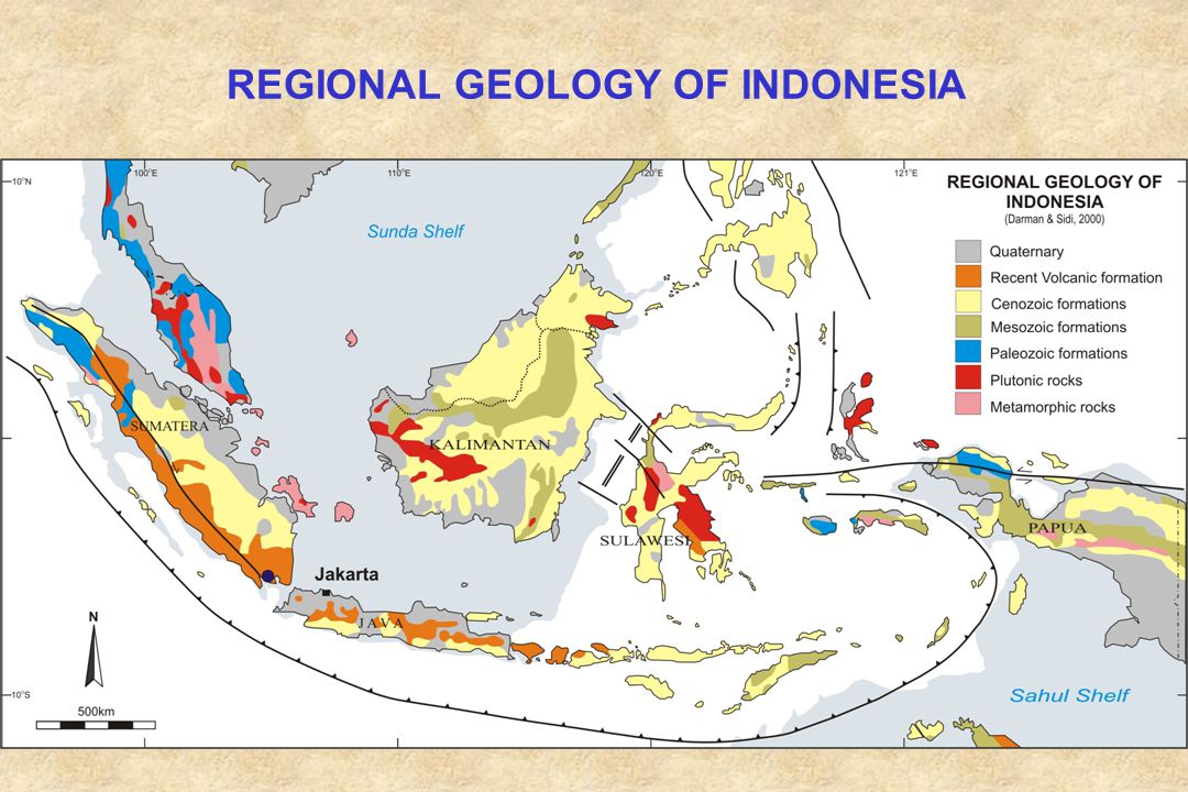
Geology of Indonesia
The Sunda Strait forms a triangular-shaped interruption of Indonesia. Indonesia’s geology is governed by the massive subduction zone to the south, where the Australian plate is diving headlong into the deep, at kangeroo speed. (kangeroos are fast: I remember going for a run and the local kangeroo population joined me, fleeing whatever it was I was running away from!). Sumatra and Java are on the edge of the Sunda Shelf, a piece of continental crust attached to Asia which has dropped below current sea level. (During the ice ages it was at sea level, above water but rather wet.) The subduction generated the usual melt and formed volcanic islands on this Sunda Shelf, some distance from the subduction trench. These volcanic islands slowly merged, helped by the area being pushed up by the descending plate below. Java and Sumatra acquired deltas on their northern side where the sea was quite shallow.
The Sunda Strait failed to take part in this merger activity, although it did have the requisite volcanic islands. What happened? It was a matter of misdirection. A quick glance on the map shows that Sumatra is rotated by about 20 degrees with respect to Java, with the Sunda Strait forming the triangle that links the two. The subduction motion is head-on in Java, but in Sumatra it is oblique, making Sumatra running (with a non-kangaroo definition of running) away from Java. The parallel component of the motion is taken up by the Sumatra fault, which runs along the length of the island. The Strait has been pulled open both by the rotation of Sumatra, and by its movement to the northwest. Which of these is more important is still being debated. The Sumatra fault peters out in the Sunda Strait but does so with some difficulty: it bends south and splits in two. In between the two segments is an area of deep subsidence, at the southern entrance of the Sunda Strait, which reaches 1800 meters in depth and explains the lack of islands west of Krakatau.

The Sumatra fault in the Sunda Strait. Source: Mukti, Ris.Geo.Tam Vol. 28, 115 (2018). https://jrisetgeotam.com/index.php/jrisgeotam/article/download/954/pdf
Because Java and Sumatra are moving apart, the entire Sunda Strait is a zone of extension. Such zones show subsidence, as in a graben. Therefore, one would expect a graben to run along the length of the Strait, perpendicular to the subsidence trench of the Sumatra Fault. Indeed, deep drilling southeast of Krakatau has found 3 km of sediments, dating to the pliocene (a few million years ago), implying the rocky bottom has sunk by at least that much. But it is not visible on the sea floor, unlike the basin between the two branches of the Sumatra Fault. The copious sediments have completely covered it up.
A line of volcanoes bisects the Sunda Strait, starting from Rajabassa on Sumatra and running via Sebesi, Sebuku and Krakatau to Panaitan Island, north of the termination of the Sumatra Fault. Of these volcanoes, only Krakatau remains active. There is an earthquakes zone along the same line in the Sunda Strait. They have a typical depth of 30-60 km, well above the subduction zone which is some 150 km deep here. The earthquakes reach up to M7 in strength with the strongest earthquakes located towards Panaitan. The last M7 earthquake was in 1943; there has not been a quake stronger than M6.1 in the Sunda Strait since 2000.
The volcanic line suggests that a fault is at play, and the earthquakes support that view. Earthquakes also have shown indications of a second fault, running along the length of the Sunda Strait. This makes sense as this is perpendicular to Sumatra and Java moving apart, and so it could take up the extension from this motion.The deep sediment southeast of Krakatau may show that this fault behaves as a pull-apart basin. It would also fit with Krakatau’s silicic lava, which indicates it may receive its magma from crustal decompression melt, rather than from the oceanic subduction. (It also means that Krakatau is much larger than it appears, as its base must be on the rocky bottom below the deep sediment.) Krakatau lies where the two faults intersect, on the crossing of a line of crustal thinning and a line of volcanic activity, a dangerous (or exciting) combination, the kind of crossing where a 4-way stop sign would be useful.
There are no accurate dates for the other volcanoes on the line, apart from a basaltic flow north of Rajabassa (Sukadana) which is dated to about 1 million years ago. There is still some fumarole activity at Rajabassa. But currently, Krakatau has no equal anywhere around the Sunda Strait.
Krakatau now

Bathymetry. Source: Deplus et al. 1995, Journal of Volcanology and Geothermal Research, 64, 23-52
The main explosions heralding Krakatau’s famous 1883 eruption started on Aug 26, after several months of activity. On Aug 27 the two largest explosions followed, 40 minutes apart; the second one caused the biggest devastation. It destroyed most of Krakatau but half of its highest mountain, Rakata, remained standing. The hole in the sea floor was 250 meters deep. Gravity measurements suggests that the explosion actually made a hole 1 kilometer deep but most of this was filled by low density ejecta from the eruption itself. Interestingly, this hole is to the west of the old island. Whilst the early activity was all on-land, the final explosion took place not on the island but under the water just off its coast. A possible model is that the first of the two explosions was the collapse of the roof of the magma chamber, occurring under the sea to the west of Krakatau. The sea water fell a kilometer down into the heat. The island collapsed into the hole to its side, and this sealed the hole. The water below boiled, but had nowhere to go until the pressure grew large enough to lift the seal. The ensuing explosion rained mud 20 kilometers away, caused the final tsunamis and made a noise heard over a sixth of the earth’s surface. There is a problem with this model which I will come back to.
There were three islands left after the eruption. Together they trace the rim of an old caldera, twice as large as the one formed in 1883. That caldera was already recognized by Rogier Verbeek in 1885 when writing his comprehensive report on the eruption. He speculated about the rim tracing the summit of an older volcano which was destroyed in an ancient explosion. There is at least one other large caldera in the Sunda Strait: gravity measurements have shown evidence for an even larger filled caldera south of Panaitin, with a diameter of 20 km. The date of the formation of the older Krakatau caldera is very uncertain. People who study deposits find it is 60,000 years old. People reading old history say it is 1600 years. Who said that the past was an open book?

Sentinel image, 3 May 2019. Anak Krakatau is now similar to what it looked like in 1940.
Anak Krakatau grew up on the edge of the hole. Interestingly, it made use of the same conduit as the 1883 eruption. The conduit should have been destroyed, but it may have survived because the final explosion, and the excavated hole, was not underneath Krakatau. The edge location made the new cone potentially unstable, as pointed out as early as in 1995 by Deplus. As had been predicted in more than one paper (but still happened unexpectedly – it can be tempting to make the wolf at the door go away by ignoring it), Anak collapsed in 2018, and its remnant is now the smallest of the four islands that make up Krakatau; the summit has been replaced by a salt-water crater lake. To the south is Rakata, which is the high peak from before 1883. To the left is Sertung (Verlaten island – meaning deserted) and to the right is Panjang (Long Island). Rakata and Anak together coincide with old Krakatau – the other two islands were already separate from it. (Another small island, called ‘Polish Hat’, disappeared in the 1883 eruption.) Since its collapse, Anak Krakatau is no longer visible from the main land: it is hidden behind Panjang which is now taller. This will remain so until the rebuilding program begins. There has been no indication of any volcanic activity since the collapse, apart from continuing discolouration of the sea on the west and south which may be debris washing into the sea.
Now we know the location, the geology and the current state. With the present covered, it is time to go back to its mysterious past. What do we know about Krakatau’s history?
Read all about the history in part II
Albert, May 2019

Breaking news: The source of the discolouration of the water at Anak Krakatau has been found.


Krakatau is a special interest of mine. I have written three posts on it in the past, but now I was interested in what it did before the big bang. I started writing a few weeks ago and it grew and grew. It had to be split, in case anyone use their mobile data allowance for VC and sue us to recover the charges. Part I is some background on the current state. Part 2 (later this weekend) will discuss its history, and part 3 (early next week) its pre-history. After that, I can finally retire Krakatau and go back to discussing volcanoes that still exist!
Thanks Albert! The regional geology impacting Krakatau is fascinating.
Totally spiffing Albert!
I would though make a case that it still exists. Even though it is nowadays named Anak Krakatau, it is as you mentioned the old vent.
And unless I was hallucinating it all, I spent a night a decade ago watching it erupt while drinking things on a beach that later got destroyed.
Wonderful place, and you brought me back into my memories.
Great article. But Krakatau still exists, even if a lot of it is under water.
Thanks Albert. Looking forward to. 🙂
Reading question arizes. Krakatau was, or is a volcano.
When is a certain named volcano is history?
The contours hidden in sea of (former?) Krakatau are quite something. Is it because the original magma chamber isn’t (expected to be) capable to get in erupting state anymore? Or is it just that the visible body of the mountainous shape of it is so damaged, that the former named volcano isn’t recognizable anymore…
Is there some kind of rule to declare a volcano ‘past time’?
The original 1800 s 30km3 magma chamber was evolved gassy ryholite and thats been blowed out….
Now fresher magma rushes in and is basaltic andesites that feeds Anak Krakatau.
A volcano can erupt several types of magma without a name change! 🙂
This is why I find the Sunda arc volcanoes so interesting.
I suspect there is a deeper source of magma that feed the chambers that go caldera, so that the caldera’d volcanoes are quite capable of rebuilding themselves.
See Samalas/Barujari.
Also there was a paper not too long ago showing Sinabung is a vent of the Toba magma system.
In other words, the Toba magma chamber is still there.
I think with this arc maybe not a good idea to assume that “gone caldera” = ” no more magma”.
Just because a volcano get a new name it does not mean that it is a new volcano per se.
Take Gagxanul, today it is known as Santiaguito, before that it was called Santa Maria. But it is still the same beast we are talking about.
I see Santiaguito as a series of vents of Gagxanul, and I see Anak Krakatau as the rebuilding main vent of Krakatau.
It just comes out of our edifice fetish. The edifice is just an expression of the real volcano, and the most interesting part is where it starts, at the bottom many kilometers down. The volcano is the point where the magma is first produced, the feeder root, deep reservoirs, conduits, magma chambers, and finally the conduit leading up to the edifice.
In my world volcanoes are the tallest mountains, often ranging far more than 50km in height. From that perspective the last fashionable cone name is rather insignificant 🙂
Found this rather nice video of Barujari eruption in 2015. That’s an active stratovolcano inside of an enormous crater.
Found an amateur video of Rinjani/Barujani/Samalas/nasty volcano on Lombok from 2015. From the translated title and comments, the person who took the video thinks what is happening is a miracle (supernatural activity).
https://www.youtube.com/watch?v=8cwy99Ip0ws
2015 is last week geologically speaking.
Open conduit simple volcanoes like Villaricca and Pavlof and Shishaldin, Stromboli
Probaly haves fairly simple upper magma systems conduit running up from the magma chambers above the partial melting
While Yellowstone and Taupo and Askja, and Medecine Lake is a crazy maze of intrusions and sills, dykes and magma chambers of various sizes and various compositions depending on Sio2 content
Most open conduit volcanoes are probably young, mostly or often entirely holocene in age and still in the initial eruptive stage that they were created by. Sometimes they get really huge this way like klyuchevskoi.
Or they are a new vent that has stayed open after a big eruption, that is most likely what santiaguito is, except in that case evidently a lot of the silicic magma was not erupted in 1902 so it has made an effusive lava cone instead of a basalt stratovolcano. At some point the dacite will run out and basalt will start erupting on top or somewhere on the dome, making a volcano like fuego or pacaya, so Carl will have 3 volcanoes to watch 🙂 or maybe it will blow up again that is also an option…
WHAT! You can’t stop there!
One of Alberts better cliff hangers…
I admit to biting my nails waiting for part two.
I enjoyed that article, Albert, and look forward to part 2! Thank you!
Agung just erupted again (it is at 2:09 AM local time 5/18/2019)
https://www.youtube.com/watch?v=WrLnnbbx0cQ
that is a live feed you have to scroll back.
Hm, wait a minute…
I am a bit slow here tonight.
Albert, did you just write above that Krakatau is sitting on a 4-way junction?
Edit: I think Lurking will also be biting his fingernails on this one if I understood the 4-way junction part correctly.
(Slowly sitting down ears perked to wait for the rest of the post, and an answer to this, bag of chilinuts in hand)
You guessed correctly. But I am not a saying a thing, waiting for the next part, or information that verifies what I read. Junction dynamics can really mess with yer head.
Despite losing most of its cone, Anak Krakatau is still erupting. Check out the seismogram:
http://webcams.volcanodiscovery.com
http://www.vsi.esdm.go.id/index.php/gunungapi/aktivitas-gunungapi/2524-informasi-erupsi-g-anak-krakatau
No ash column was seen so possibly submarine?
How is that for timing. I was of course trying to stir things up a bit – but hadn’t expected Anak itself to respond. A google translation:
There has been an eruption of Mt. Anak Krakatau, Lampung on May 17, 2019 at 08:05 WIB but the ash column height was not observed. This eruption is recorded on a seismogram with a maximum amplitude of 45 mm and a duration of ± 5 minutes 4 seconds.
At present G. Anak Krakatau is in Level II Status (Waspada) with recommendations:
People / tourists are not allowed to approach the crater within a radius of 2 km from the crater
I do wonder what separates tourists from people..
As for it no longer existing: there is no summit at the moment, just a hole. But that is a temporary set-back. In 80 years it will be as good as new. In 90 years it may be gone again. Plenty of magma still around with an open conduit. If it grows at its previous speed, then the crater lake could be gone within two years.
The 4-way junction is based on the two crossing faults. In fact if you look at the bathymetry, people have argued for another fault running east-west. That could be related to the Sumatra fault subsidence, but I felt the evidence was a bit thin on the ground. A 6-way junction seems too complex. Do remember that in Indonesia they drive on the
rightleft ..One of the deepest manually reviewed Pahala quakes
https://earthquake.usgs.gov/earthquakes/eventpage/hv70954496/executive
M 2.1 Other Event – 9km SE of Pahala, Hawaii
Time: 2019-05-15 22:48:08 (UTC)
Location: 19.136°N 155.427°W
Depth: 53.0 km
Currently 26 deep Pahala area quakes in last 7 days.
I noticed the sudden appearence of a lot of sizable orange circles in that area too, probably a lot of magma on the move as these quakes are actually much larger than the magnitude shown taking into account how deep they are and the strength of the surrounding rock (not high). Its probably not why kilauea is reinflating now, it takes a while for magma to get that far, but a few years down the road some interesting things could happen. No word on gas emissions yet but HVO might be waiting until Tuesday or later to say anything so they dont jump too far ahead.
It will be fun to see the next eruption be a cute little spatter cone 🙂 in halemaumau and still the daily fail will use a picture of fissure 8 and say it is going to happen again… I think after last year kilauea has gone to even second place on their clickbait volcano list (we all know what #1 is and it will never be dethroned)… I hope im not the main reason though, I know this place has been on the wrong end of the ‘fail before and some of the ideas I had last year and even only a month ago were… a bit alarmist… I guess everyone here has probably had that phase though, the same thing happened a lot after holuhraun, people look at big things suddenly stopping and think it cant just be that simple when it really is sometimes but we overthink and overanalyze it too much. Thats why that dutchsinse guy on youtube gets so many wives…
🙂
My neighbor asked me about him the other day. I can’t repeat my answer.
I think you just explained why Dutchinsense does what he does. All those wives he gets. 🙂
It is meant to say views but my phone has stupid autocorrect so it chose that instead… 🙂
It was definitely better this way.
I think your auto-correct hit the nail on the head. He is in for it for the babes, and sadly it seems to be working quite well for him.
Exactitude in information is not required for procreation it seems.
https://www.hawaiinewsnow.com/2019/05/17/scientists-consider-raising-mauna-loas-alert-level/
Latest
M 2.5 – 27km E of Honaunau-Napoopoo, Hawaii
Time: 2019-05-18 14:24:09 (UTC)
Location: 19.464°N 155.600°W
Depth: -2.3 km
I also see CO2 at Mauna Loa now over 415 ppm, All data NOAA
Preliminary weekly (red line), monthly (blue line) and daily (black points) averages at Mauna Loa for the last year.
Week beginning on May 5, 2019: 414.37 ppm
Weekly value from 1 year ago: 410.77 ppm
Weekly value from 10 years ago: 389.79 ppm
Latest Daily: May 17, 2019 415.22 ppm
Last Year: May 17, 2018 412.01 ppm
Record Daily: 415.64 ppm on May 15, 2019 (NOAA-ESRL)
Record 2018: 412.45 ppm on May 14 (NOAA-ESRL)
The difference is not that big, indicating that magma is present, but is not currently rising upwards. Just a happy volcano doing what volcanoes do until they erupt.
In other words, not gonna erupt for at least a week. But for once I am actually keeping an eye on a Hawaiian volcano. You can interpret this as you wish.
And huge it can get too
Mauna Loa is capable of many many km3 sized flood events in a few weeks to months IF it really wants ( summit collapse even that happens ) drainage
But thats a topic for another Article … when Hawaiis Laki will happen we dont know.. and not under my lifetime…
It was 1400 years since the 8 to 11km3 panawea lava flood in Hilo
Mauna Loa have had 40 years to recharge now
The next event coud be year 1950 sized .. or little bigger.
And south rift is most likley.
Kona and The beautyful small town coast in west Hawaii is under large Hazard from fast moving flows.
The next event is very unlikley to reach Leilanis volumes if it happens now.
But the next Mauna Loa event will start much much larger than Leilani ever did.
The next Mauna Loa event if it follows the typical large rift eruption pattern will erupt many 100 s of millions of cubic meters in a few weeks with most of it in the first days of eruption.
These eruptions are hazardus on the rather steep slopes on Mauna Loas south parts
Steep slopes and huge output of highly fluid basaltic lava..
If it happens in night.. persons in Kona and West side of Big Island may have just hours or an hour or less depending on eruptive rates.
HVO is concerned about that.
Imagine waking up in the small town heaven and upslope is a wall Of Aa lava moving much faster than you can walk
I can recommend some reading to get ready
https://www.volcanocafe.org/trouble-in-paradise-awakening-mauna-loa/
https://www.volcanocafe.org/pela-paha-mauna-loa/
Most recent eruptions of Mauna Loa have been small. But that is not a guarantee. And extrapolating (wildly) from the recent sequence, the next target could be Kealakekua Bay. Now that would be a disaster. Of course, in reality the direction of flow is random.
Well, assuming it follows the same pattern as 1975 and 1984, an eruption is still at least a year away…
From what I have seen the amount of inflation in the last 5 years at mauna loa is about 1 microradian, 1 millimeter of uplift since 2015, while kilauea does 50 times that in 2 months, the only reason kilaueas deformation looks small is because of the scale, mauna loas scale is really zoomed in.
If it does erupt it also probably wont be big either, like 1975, a bigger eruption will happen eventually within about 10 years of that but really I would rather look at the implications of kilauea inflating at a shallow level where SO2 can escape but there are no increased gas emissions. If that goes on long enough the next eruption could be a lot bigger than anyone expected.
If things really do go pear shaped at mauna loa though we are looking at an eruption about as big as 1984, 1950-1984 is about as long as 1984-2019, so assuming pretty constant supply it should be about the same. If it erupts on the southwest rift then it will be like 1919 or 1926 in scale, meaning big but not lava-flood-flowing-faster-than-you-can-run big, maybe 1 or 2 days between the start and an ocean entry. 1950 was rather huge compared to the other historical eruptions there and more of an outlier.
Not sure about your units. Mauna Loa has risen by about 17 cm over the past 5 years. (From MLSP which is the one plotted by HVO.) Also note that by picking 2015 rather than 2014 as starting point you may be leaving out the big surge in early 2015 while including the flat recover from this. (I assumed you picked four years, i.e. started from June 2015.) As this biasses your number downward, you can’t than argue ‘look how small it is’. It is essential to be aware of any bias in your numbers.
I was looking at this one, which is cross caldera distance, it seems like you are using uplift which is indeed about 17 cm, so much more interesting. Still not that much compared to kilauea, which will get that far in a few months if nothing changes and has already done more on the east rift, but 17 cm is a much more solid number that I can understand maybe raising an alert for. I assume this is the one you mean:
Its still way less than 1975 inflation though, or 1984, we are probably still quite a way off from any eruption, at least a year like mjf said.
But it is very likely mauna loa will do a big eruption before kilauea does another really big eruption again, some time in the next decade but probably sooner than later, kilauea will probably need at least 10 years to do something liek pu’u o’o again.
But mauna loas next eruption wont be an eruptive episode like what happened 1843-1950, just a one off event like 1984 and then a lot more decades of nothing, possibly a lot more than 36 years. It would not exactly be a good idea to rebuild in lava zone 1 in lower puna because if you are under 30 it is almost certain to erupt there again in your lifetime, but we wont know until that happens of course and I will probably be really old when it does 🙂
I also misread meters as microradians because it was a small screen, so disregard the 1 mm uplift comment… 🙂
These days Mauna Loa eruptions are often quite voluminious and large…… but the volcano shows diffrent types of effusive vigour. from large fissure eruptions like 1950 s , 1980 s . These eruptions erupts from the Rift Zones and forms huge curtains of lava fountains and you have an enromous flow over the surface. and huge fast flowing lava channels froms that feed fast flowing aa lava flows that advances to coasts. Thats what Mauna Loas current mood is huge fast rift fountain feed eruptions that feeds fast moving open lava channels and Aa flows.
The current high volume short rift eruptions is what formed all the Black flows in Google Earth and Aa channels.
But much of Mauna Loas older Brown weathered surface is pahoehoe.
To older and much more slower long lived eruptions…a large part of Mauna Loa is covered by pahoehoe suggesting earlier tube feed flows that where feed from a summit lava lake and eruptions resembled todays Kilauea. Souch effusive pahoehoe phases can last for many 100 s of years longest in holocene 1100 years I think. This is seen by near constant lava lake activity and lava lake overflowing and lava lake tube feed pahoehoes, from which large sheets of tube feed pahoehoe blanket the northwest and southeast flanks. The last such period of non stop summit activity lasted for about 800 years non stop with lava lakes in the summit and tubes feeding large pahoehoe eruptions downslope. between 1,200 and 2,000 radiocarbon years ago and was accompanied by frequent smaller eruptions from radial fissures on the northwest rift flank. This period of summit overflows may end when a large flank eruption occurs low on the flanks and robs Mauna Loa of the high- level magma collum required for long lived slow shield building.
The sudden lowering of the magma column associated with caldera drainage results in a major change of activity as both rift zones become characterized by many large scale eruptive activity. Sporadic ummit activity probably continues during times of heightened rift activity (as it has during the 19th-20th centuries but all erupted lavas are trapped within the summit caldera and no summit lava lake, and no signs of this activity remains at the geological surface.The fissure rift eruptions are mouch mouch mouch larger than the summit eruptions in flow rates and forms huge very spectacular eruptions like Panaewa and 1950 s and 1980 s
As stresses increase across the rift zones over time, magma again rises more easily within the edifice, and the caldera is filled. A lava lake appears at Mauna Loa’s summit, pahoehoe sheets are able to overflow the caldera walls, and the long cycle of Puu Oo like shield building begins again
USGS suggest a cycle where Mauna Loa constantly shift from large Rift Eruptions to Very long lived pahoehoe shield building and lava lake activity
It’s amazing the rate of CO2 increase worldwide. At a rate of 4ppm rise every year, we will be at 500ppm in 20 years, and near 800ppm by end of the century. That’s as much as ice-free periods in the world, where world was subtropical at the poles.
Iceland will be a subtropical paradise!
The equator will be a humid hell thpugh, not a desert by any means but too hot to live in, so 1 billion people in sub saharan Africa and India abd south east Asia each will need to go somewhere else and no matter what your opinions are that will have a lot of problems of all sorts. Iceland, new zealand and southern australia will become dense metropolitan megacities, the equator will look like tropical chernobyl, and there will probably be permanent settlements in Antarctica all along its coast within this century.
That is if things go well, if they dont then it wont only be the equator that looks like chernobyl…
If things go really well then the world will be like today but with much less fossil fuels. Only rockets really get away with fossin fuels, everything else if I was creating the world would be where cars run on fluoride ion batteries (look it up) ships run on nuclear, planes run on hydrogen or biofuel and big trucks run on aluminium air batteries and where a big investment is made in hydrogen and sodium chlorine batteries (my own invention) but even the most optimistic person has to be realistic sometimes.
Indeed its scary
Yup we humans release as much Co2 as a really large flood basalt eruption. Human Co2 is rising very very very very quickly
The humans will make Earth Into Eocene Greenhouse
Imagine in year 2500
Icelands coasts dotted with Palm trees and corals grows in the waters thats become crystal blue tropical
Pengiuns and polar bears are all exctinct replaced by subtropical versions. The equator and subtropics will become too hot to live in. In Eocene equator had avarge shadow temps of around 39 C 10 c warmer than today
I hopes Turtlebirdmans Bright version of the future is correct
Fossil fuel free. With humans living underground and in large cities underwater and hydrogen planes and nulcear ships and cars that runns on batteries
Aaaaand colonies on the Moon
World is warming very quickly
I live in the Artic … North polar while Im milded by the Gulf Stream
I have noticed in my 23 years of life that Sweden is getting warmer and warmer and warmer in winter…
And my dad thats 65 years old says its an enormous diffrence winter today and winter in 1955
When my dad was small.. winter in Sweden was always quite severe
Today its often quite mild and above freezing in many places
Getting warmer and warmer
Interesting observations Jesper.
In case anyone is wondering (also because I want to write it somewhere 🙂 ) my sodium chlorine battery would be run off of NaK metal alloy and BrCl, so its sort of more a general alkali metal halogen battery except it is all liquid so no annoying slow kinetics or exploding gas canisters. NaK is made of sodium and potassium metal and is liquid to -12 C and adding a small amount of cesium makes its melting point as low as -90 C (cesium is very expensive but it would also be reused maybe), BrCl is made by reacting bromine and chlorine and it is a liquid between 5 C and -60 C and able to be compressed easily to liquid at room temperature. All 4 of these elements are found in seawater in abundance. The temperature range also means these batteries would be fine in cold places which is a problem for most rechargable batteries. Im not a battery scientist (or any scientist actually 🙁 ) so theres probably way more to this but it seems like a way better idea for big energy than making lithium ion batteries the size of a 10 story building which would be a disaster if it shorted itself (which is certain to happen if they become common) even spilling 1 ton of liquid chlorine wouldnt be as bad as a 100 megawatt battery going into thermal runawaw…
Sodium chlorine reaction.
https://www.youtube.com/watch?v=ji_25I_q4LQ
Or if you want to be an absolute mad lad you can make hydrogen fluorine fuel cell 🙂
a Wonderful “Popcorn” article…. waiting with ‘baited’ breath! motsfo
What a great article Albert! Looking forward to more. I was caught a bit off gouard with this, since I could perhaps try to produce a plot or two, like gravity anomalies or bathymetry or tomography. Will still try to produce some.
First I thought it was a nod to my cliff-hanger on the last Greíp-chapter.
But, not only did Albert out-cliffhanger me, he out-4junctioned me. 🙂
Edit: I have decided that it is time to open my bottle of Chateau Haut Brion 1er Cru Classé Pessac-Léognan 1985 this evening. I think that will go well with the next instalment of Alberts Krakataufest. And since I am me I have preloaded Erasures version of Take a chance on me to accompany things. I know, I do not party like the rest of the planet. 🙂
Actually, the next instalment is not due until tomorrow.. I am still polishing it (polishing Krakatau sounds like cleaning the deck chairs on the Titanic, but I can’t help it).
According to sources the chairs was well waxed, and the last time I saw Krakatau it was really shiny in the night.
Ahem, well I will have to find something else to do while drinking the bottle.
You could just look at it until the next episode of course?
By golly you will appreciate it by then!
Mind you I have a jaundiced view of expensive wines having had (quite) a few and often found them inferior to the best £10 supermarket ones. The only problem is that out of every twenty £10 supermarket offerings one is exceptional,three very good, 12 good, three poor and one not worth cooking with.
The difference from wines 40 years ago is immense and reflects the improvements in viticulture and winemaking that has happened over that time. A poor fermentation is never a hazard (unless deliberately bought by the buyer) and varieties and harvesting techniques have improved in leaps and bounds.
Expensive wines tend to have corks, and are nowadays not infrequently corked, sadly.
So you’re not popping a cork on a Chateau le Pin Pomerol 2001? (As served by accident in a UK restaurant instead of a £260 bottle of plonk…)
Also its probably oxidised by now, like almost all the really good bottles I have kept back. Best to drink them whilst they are good .
Not a big chance of that, it has been stored properly, the other bottle I had was quite sublime.
Great Article-can’t wait for part 2 Albert.
Here is an older Sky and Telescope on Edvard Munch,
“The Scream” and how Krakatau was a world wide event.
https://www.skyandtelescope.com/press-releases/astronomical-sleuths-link-krakatoa-to-edvard-munchs-painting-the-scream/
If something like that happened now the Daily Fail would go apoplectic.
Oh wait. they go apolectic over a 2.3 under a Yellowstone geyser..
How Anak Krakatau will behave depends alot on how fast the magmas rise to the surface.
1930 s until today now 2019 its rising quite fast and competely open conduit
Its been basaltic andesite with vulcanian explosions and violent strombolian activity and large viscous lava fountains. And large viscous Aa flows like Nishinoshima ( similar viscosity )
Anak Krakatau 2018 was likley caused by a massive sourge of fresh gassy magma explaining the huge lava fountains just before the collapse.
If it continues like this it will quickly rebuild itself in a few decades.
For now the volcano is not in danger of doing major plinian caldera eruptions
Erupts too frequently
And since it is Saturday we need a volcanic soundtrack to carry us as we eagerly await the next Krakatauan episode from Albert. Anyone not getting the reference can sign up for volcanic evening school 😉
https://www.youtube.com/watch?v=fCP2-Bfhy04
And since it is Saturday we need a volcanic soundtrack to carry us as we eagerly await the next Krakatauan episode from Albert. Anyone not getting the reference can sign up for volcanic evening school 😉
OT: Mt. St. Helen’s blew itself to kingdom come 39 years ago today. All over the news on the West Coast of the US today.
Mt. St. Helens….not possessive. Dang you, auto correct.
“Vancouver! Vancouver! This is it!”
https://en.wikipedia.org/wiki/David_A._Johnston
The bad part? Johnston was one of the volcanologists who was arguing for a flank collapse style of event. He knew and expected that style of eruption. Though I think it was a magnitude or so larger than he thought.
I flew by St.Helens on the 17th goat rocks looked like they could’ve slid andy moment let alone blast out into smithereens.
“At any moment.”
To forestall any confusion, Johnston was referring to the Vancouver in Washington State (the Cascades Volcano Observatory is headquartered there), not the Canadian city to the north.
And yes, I’ve heard things about drivers getting confused as to which “Vancouver” and ending up in the wrong direction while driving in Washington. Vancouver in Washington State is located right across the Columbia River from Portland, OR.
Finally, decent news from the internet. She’s gonna be okay.
(This is a follow up to something I noted in the back channel)
https://www.saturdaydownsouth.com/auburn-football/auburn-softball-pitcher-carted-off-field-after-taking-line-drive-to-face/
That hit could have killed her. The drive nicked her glove and caught her square in the forehead.
And from a motivation point of view, Colorado St could not get a runner past 2nd after that happened. The Auburn girls were vicious in their fielding after that.
Anchorage had another M4 aftershock from the December event.
Grandkids are visiting so this tired g-ma hit the hay early and missed it. Not very many people felt it in my area anyway… and i think people are tired of reporting what they felt… but here’s a funny side story… on the 7.1 a brother in law in Anchorage was driving at the time and didn’t feel anything but did notice all the traffic lights went out….. after arriving home he found his wife standing in the middle of the front room with frightened look and he asked her : “What?” … she couldn’t believe he didn’t know what had happened…. and remember; this earthquake did some pretty significant damage. Must be a little non observant, eh? Best!motsfo
I have had the same experience: the largest earthquake I have bene in I completely missed because I was in a van on a bumpy road. (Bumpy: think unpaved, mountainous). None of us felt a thing. Now I had been up all noight so wouldn’t have been in the best of shapes, but the driver also didn’t notice. That would have been a high M5: nothing like what you experienced.
Unless an earthquake is really big, think M7.5 or larger, the shock absorbers and the bumping of the road au naturel would make it impossible to notice an earthquake in a rapidly moving car. It would just be felt as a few road bumps.
And as general comment, may I recommend to keep the comments brief, if possible? I am probably not the best person to make this point (look at my posts..), but when comments get too verbose they are better used as a start to a post. Imagine VC comments to be like a cross between twitter and facebook. (TwitFace? I may be on to something.)
Aww…
I like lurk’s (and other people’s) off-topic (lengthyish) ramblings…..
I do to, but there must be some sort of moderation to the amount of comments made.
We just want all users to be able to comment without drowning a hailstorm of comments from just a couple of people.
OT and long ones okay, but with a bit of limit being the thing…
And if you feel the need for a 15 page long comment… Email and we will hack it up to an article instead (if up to measure).
Allow long comments… many persons loves volcanoes and have lots to say
Part II of the Prelude to Krakatau is up! It is history – with all the boring bits left in and the eruption left out.
https://www.volcanocafe.org/prelude-to-krakatau-part-two/