Continental drift was dead. The idea had been around for a long time. Just a cursory look at a map shows the similarity between the coast lines on either side of the Atlantic ocean. They fit even more precisely when looking at the continental shelf rather than the actual coast line. Even better, the geology on either side fits as well, with the Norwegian mountains continuing into the Appalachians. It could be seen elsewhere as well. Madagascar fits snug against the African coast. Western Australia looks very much like South Africa. Fossils on either side of these divides were similar, at least for older species. In some cases, living plants had relatives on the other side. Alfred Wegener wrote this down in 1915, translated into English in 1922. But the idea had a fatal flaw. There was no mechanism to make continents move across the globe. It couldn’t be an external force, and there was no suitable internal force. So continental drift died.
Resurrection came in the 1960’s. Our understanding of the Earth was growing, and the similarities became more and more undeniable. And then the trumpet call came. Stripes of opposite magnetic field directions were found in the rocks on the bottom of the ocean. Each stripe could only date from a time of before a reversal of the Earth’s magnetic field. But that meant that the ocean floor was very different from the continents. It was continuously created. Here was the mechanism that could move continents, one that could create the oceans between them.

And then it died again, or at least metamorphosed. The driving mechanism came in doubt. The convection currents in the mantle seemed unable to move the ocean floor. The friction between the mantle and the oceanic crust, down in the asthenosphere (the ductile layer between the two) was not really high enough. A new driving mechanism was required. This became the oceanic subduction. The oceanic plate sinks down in subduction zones, pulled down by the irresistible force of gravity. It happened naturally when the plate cooled and became denser than the mantle below. It turned out that this pull on the sinking plate was sufficient to get the whole plate to move towards the abyss. It is not the only force in action: mantle convection in the asthenosphere still contributes and gravity also works through the mid-oceanic rifts which around 4 kilometers high so that the whole plate continuously moves downhill, like a reversed Escher drawing. How much of the force comes from each component is still being disputed, especially because there is disagreement on the viscosity of the asthenosphere. But there is general agreement that ‘slab-pull’ on the subducting plate is the largest contributor.

As the oceanic plate begins to subduct, the plate on the other side of the subduction zone will be pulled in to fill the gap. If that plate contains a continent, the continent would find itself being pulled towards the ocean. So now the drift of the continents was nothing else than a side effect of the subduction of an oceanic plate. The name ‘continental drift’ seemed inappropriate, as it focussed on only one and a rather minor aspect. Instead we now call it ‘plate tectonics’. It is no longer limited to the continents: the oceans are by far the more important aspect. School children learn about the plates and can recite their names. The plate edges are easily recognised just by plotting the locations of volcanoes and earthquakes. The ‘ring of fire’ that surrounds the Pacific ocean leaves no doubt about the main mover and shaker of the Earth. All of us dance to the beat of the Pacific plate. The wide stillness of this ocean hides a big power. So the queen of continental drift is dead: long live the king of plate tectonics.
Plates
The Earth contains as many as 70 separate plates. That is rather more than the average school child has to memorize. There are 16 major plates; all the others are platelets and microplates: small bits that survive from previous subductions or have split off from other plates. The most recent addition has been the Malpelo plate, a microplate located between the Galapagos islands and South America. An other addition from the last 20 years has been the Sierra Nevada Microplate. Each plate can move somewhat independently from the surrounding ones.
There is no clear distinction between oceanic plates and continental plates: a single plate can contain both ocean floor and part or all of a continent. The Australian plate is a good example. Plates can also be purely oceanic or purely continental. If a continent rifts, the rift develops into ocean floor, so that what used to be a continental plate now becomes two mixed plates. Plates are not eternal. The boundaries change, parts can change allegiance, a collision can become an annexation, and oceanic plates can disappear completely. Of course where a plate contains a continental and an oceanic part, the oceanic part may begin to subduct and now the two parts will be separated. These linkages tend to be temporary.
The only constants are the continents: they are low density and float on top of the sea of plates, and therefore can’t subduct. Look at the plates from below, and the situation reverses. The continents have deep keels and stick out far below the ocean floor. Some of the keels can be over 100 kilometer deep, while oceanic crust is only around 10 kilometer deep.
The latest map of the Earth’s plates can be found in Hasterock et al, 2022, Earth-Science Reviews, volume 231. The basic map of the major plates is shown below.

The definition of oceanic crust is based on density: it is formed by seafloor spreading which brings up mantle material. This is the reason why the oceanic crust is of similar density to the mantle. Continental crust has much lower density. Oceanic volcanic arcs are an intermediate case: they are formed on top of oceanic crust, but the magma is different (separated) and the volcanic mounts themselves can be considered as continental. When a volcanic arc reaches a subduction zone, the oceanic crust dives down but the mount may survive. It can be added to a continent in this way, making them grow. This was how the first continents began to form.
It can be difficult to give an exact location for a plate boundary. Often there is a deformation zone, where one plate affects the other. These zones can be as wide as 100 kilometers, have GPS movement different from both plates but controlled by them, and have earthquakes. These are often volcanic regions. 80% of all volcanoes are located in deformation zones and microplates even though they form only 16% of the Earth’s surface. In a subduction zone, the volcanoes are a bit further from the plate boundary, by up to 200 kilometers.
Plate motions

Here is a map showing how all of the plates are moving. Australia and the Pacific plate are moving fast. India is also racing. This map shows all relative motions. It assumes there is no net movement: Adding up all movements together, the result is zero. It is called ‘no net rotation’. It is what you would expect: the subduction is vertical, and therefore the plate motion caused by this mechanism should average out over the entire world.
But does it?
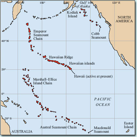
Where everything is moving, it can be difficult to define a reference frame. Most commonly, the hot spot volcanoes are used for this. They are assumed to come from deeper down in the mantle, and therefore should be stationary and not affected by the movement of the plate on top. This is why we have these long trails of ageing volcanic islands. The Hawai’ian trail is best known, with a line of seamounts going northwest. Halfway there is a change of direction. This trail is assumed to be caused by the movement of the Pacific plate carrying away the older islands. The kink was caused by a change of direction of the plate. The same direction and change is also seen in other seamount trails in the region.
If we take the hot spots as stationary, then we can use the hot spot trails to get the absolute velocities, relative to the deep mantle. And now the pattern looks very different. Africa is now slowly drifting to the west rather than faster to the northeast. Parts of South America also have acquired a westward motion. Antarctica remains near stationary though.

So the reference frame can make a large difference in how the plates are perceived to move. The hot spots provide this frame. But there is growing evidence that hot spots are not as stationary as hoped. It seems they can move around by up to 10 degrees in latitude and longitude. There is also the problem of ‘deep versus ‘shallow’ hot spots. Typically, a hot spot associated with an oceanic rift is more likely to be shallow: this includes places such as Iceland and the Azores. They may be moving with the rift, and cannot be considered stationary. So hot spots are divided into groups, and models made how each group may be moving. The plate motions are then registered to a particular frame. A plethora of such models has grown up, each slightly different in the results. Some have argued that there is no solution: the hot spots just cannot be used, because they move around too much.
An example of a paper aiming to determine the motion of the deep hot spots is Wang et al. 2018. They find that hot spots and deep plumes tend to move opposite to the plate, and towards the mid-oceanic ridges. In their model, the Iceland plume turns out to be near-stationary with respect to the European plate. Over 40 million years, it has moved by some 20 kilometers. This explains the stability of Iceland, and it’s lack of a chain of islands. It also means that the whole Eurasian plate is near motionless. In spite of its size, the Eurasian plate contains no hot spots, and therefore no volcanic trails which could be used to confirm (or deny) this hypothesis. The figure below is from their paper. The red arrows show the movement in the ‘no net rotation’ frame (where the arrows add up to zero), and the black arrows show the movement in their reference frame. Note the lack of arrows in Europe, and the fact that the plates now show a tendency to drift westward.

There have been other attempts. It appears that Africa is a fairly stable continent that is not moving much. It has no subduction zones anywhere near, and the Red Sea rift protects it against any pull from the Arabian plate. So models are made that assume that Africa is stationary. Antarctica, another continent which lacks active subduction zones (the one around the Antarctic peninsula seems to have become inactive – frozen, one might say) is also used as a stable reference, but this is not so useful as it can only move north-south, being located around the south pole. It can’t provide a reference for east-west motion. (Imagine being given a treasure map with directions ‘Go the South Pole. The treasure is buried two miles to the east’.)
All these plots are on a square grid. The Earth is in fact round. (If this comes as a surprise to some, do realize that continental drift would be a recipe for disaster on a flat earth, and read the post on pseudoscience.) The curvature of the Earth causes the vectors on the square grid to become curved, while in fact they are straight on a round Earth. For a good overview of movement on the round Earth, this wikipedia link (beware: it is large) shows a brilliant but very large image. The orange dots are the hot spots. The vectors here are with respect to a presumed stationary Africa.
Go west!
There is yet another twist to the story. We have a variety of reference frames tied to the deeper hot spots. These exclude the presumed shallow spots which come from the upper mantle. We can also create a reference frame from those shallow spots. That gives the following pattern (Doglioni et al. 2015):

Now all plates are moving west! Even Europe, which other frames bring to a halt, is now taking part. Australia, previously moving northeast, now has a northwest component. The authors have defined a so-called ‘tectonic equator’ which runs from South America to China and back down through Africa. The ‘tectonic pole’ is in the southern ocean, somewhere between Africa and Australia but shifted towards Antarctica. They show that subduction zones that subduct westward are steeper than those that subduct to the east, which would reflect that the subducted plates shed the plate velocity and start moving with the mantle flow instead.
It is fair to say that this is not universally accepted. There are many different reference frames: the westward drift depends a lot on which frame is selected. The reference frame without rotation of course shows no net drift at all – it does so by definition. Other show less drift than seen in this extreme example. All others show some tendency for the plates to be drifting westward. However, it has been pointed out that this may be caused purely by the movement of the Pacific plate. It is such an important driver of plate tectonics, and the owner of most of the active subduction zones. Are we just seeing the behaviour of one oceanic plate? The ‘tectonic equator’ runs around Australia and Europe: is it just that these are the least active regions of the Earth and happen to be opposite each other? Going back in time, the Hawai’ian chain of islands shows that the Pacific plate changed direction around 45 million years ago. If we use this change, the westward drift may disappear. Did the westward drift only begin at that time, and is this just a random fluctuation of our plate tectonics over time? Many questions. We live in an era which is defined by two things: the decay of the enormous Pacific plate which is fraying at all edges and begins to resemble the decline of the Roman empire, and the high-speed collision of India with Asia, a final event in the closing of the ancient Thetis ocean. Perhaps we should be cautious with drawing far-reaching conclusions from a phase in the Earth’s evolution where so many of the plates are passive, playing the role of a silent and therefore ignored electorate.
And what is so special about the west anyway? Why would the plates follow this direction?
Chasing the setting Sun
The Sun rises in the east. This is known to everyone, although perhaps mostly unobserved by our students. But of course, this is not true. The Sun isn’t doing anything. It is the centre of the Solar System, and far too important to do the Earth’s bidding. Instead, it is the Earth which is doing the work. The Sun is staying where it is, but we are attached to a rotating Earth. The Sun is rising in the east because we are moving in that direction. The Earth is rotating eastward. That is why the US is launching its rockets from Florida and Europe launches them from Guyana in eastern South America. By launching rockets eastward, they get a helping hand from the Earth which is already moving in that direction. (And when the rocket doesn’t make it, it will crash into the ocean which is far safer for people.) (Lurking tells the story of tracking a missile traveling east over the Atlantic, before realizing it was the Space Shuttle which had just launched from Cape Canaveral.)
Our day is 24 hours long. That tells you how fast the Earth is moving. There are tiny fluctuations in this speed. A large earthquake can cause the Earth to slightly speed up as it makes the Earth a little flatter, just like a dancer in a pirouette can regulate her speed (always a she) by pulling in her arms. Global warming is causing a slight decline in the speed of the earth because it removes ice from the poles and causes sea levels to rise – equivalent to the Earth stretching her arms a bit. But those are minute (though measurable) changes.
But there is a more major change.
Some of the oldest rocks on Earth are found in South Africa. The Moodies group is 3.2 billion years old, and is remarkably well preserved. The deposit studied here is found on the Sheba river, near Barberton. It shows layers of sandstone, separated by thin layers of mudstone. This was interpreted as a tidal estuary, where the sandstone came with the flood, but the mudstone was deposited as the tide turned and the water became still. The ebb again would deposit sand, before another mud layer. The thickness of the layers showed the neap-spring-neap tide sequence. From the number of individual layers in a neap-spring-neap sequence, you can get the number of days in a lunar month. The layers were first measured in 2000 (Eriksson & Simpson) but re-analyzed recently by Eulenfeld & Heubeck (2022).

Eriksson and Simpson (2000)
The data gives (via some complex math) the number of days in a lunar month, the number of days in a year, and the length of each day. These were quite different from modern values. Nowadays we have 365 days in a year: at that time there were about 700. Each day lasted 13 hours and each lunar month contained 32 of these short days.
How is this possible? In fact we already knew tide marks in much more recent geology that about 600 million years ago, the day was about 20 hours long. This new result extends this trend much further back. The Earth was rotating faster than it is now. We are slowing down. And the Moon used to be closer to us. It has moved away. That is still going on: from radar reflectors left on the Moon by the Apollo astronauts (science deniers look away now), we have measured that the Moon is moving away from Earth at about 4 meters per century. (Is that perhaps why we need such an expensive rocket to get back to the Moon?). And the days are still getting longer – by 2 milliseconds per century. Every day we have to work a little longer!
The Earth is rotating towards the east. A westward drift of the plates means that the rotation ever so slightly slower than the rest of the Earth. Are they showing the effect of the lengthening of the days? A westward drift of 1 meter per century would correspond to (very roughly) the length of a day that is 3 milliseconds too long – or a few centuries of climate day length change. Are the plates just running ahead in the global slow-down?
Friction of the tides
What is causing the Earth to slow down anyway?
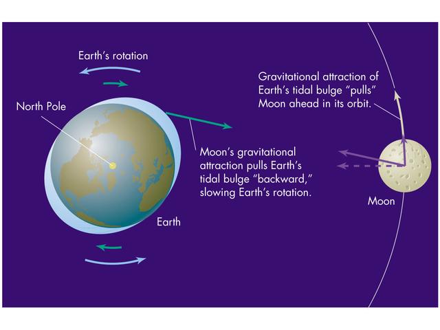
The oceans are far from pacific. They have waves and storms and tsunamis. And twice a day, they have a bulge. We call it high tide, and on the coast it can be meters high. The bulge is caused by the gravitational pull from the Moon (and to a lesser degree the Sun – I am ignoring that here).
The Moon is orbiting the Earth in just under 30 days. The Earth is rotating 30 times in that period. So the Earth is moving far faster. The tidal bulge must be falling behind the rotation of the Earth in order to stay underneath the Moon. If we know that the Earth is rotating to the east, it follows that from our perspective, the tidal bulge is traveling to the west.
That is what it would like to do. But the ocean is rotating at the same speed as the rest of the Earth – otherwise there would be obvious problems for the 80% of the world’s population living near the coast. So while the bulge wants to follow the Moon, the ocean themselves pulls it east. The result is that the tidal bulge moves ahead of the Moon. And the Moon’s pull is no longer just up, it also pulls back. A new balance is established where the pull back from the Moon is equal to the pull forward by the ocean.
The back-pull is not without consequences. A bulge of water a meter high and 1000 km wide is pulled back. This is the force which is slowing down the rotation of the Earth. One thing that is still needed is a way to transfer the lost rotation to the rest of the Earth. That happens by friction. There is not a lot of friction in water, but there is in the continents. The friction therefore happens near the coast, in shallow water where the bulge is sitting not on oceanic water, but on continental rock. It is the coastal tides where the Earth is slowing down.
There has to be balance. If the Earth slows down, the Moon must be speeding up, by the law of physics which states that action equals reaction. If a satellite goes faster, it will move further away. So the Moon is moving away from the Earth by the power of the tides.
Of course the inertia of the entire Earth is enormous and the effect is tiny. But geological time is very long. Over three billion years, the Moon has moved away twice as far, and the Earth’s day has become almost twice as long. In those days, the 7am alarm clock would have come twice as quickly.
Plate tectonics or Continental drift
How does this work with the westward drift of the plates? It is important to recall that this drift is not universally accepted, and may even be just a random fluctuation. But it does make sense from how the slowing down of the Earth works. The friction with the tides (called, of course, tidal friction) occurs at the surface of the Earth. It slows down the plates. So it would not be unexpected that the plates have slowed down most.
It depends on how the asthenosphere really works. If the viscosity is high, then the slow-down of the plates is efficiently transferred down. If the viscosity is lower, then this transfer is much slower. A low viscosity would predict the westwards drift of the plates. A high viscosity would not.
So is the viscosity of the asthenosphere low enough? The answer is, we don’t really know.
I want to end with one final bit of speculation. Why does Earth have plate tectonics? It is not enough to have plates: the plates have to move in different directions to create the space for mid-oceanic rifts that cycle the mantle material. Subduction by itself is not enough: there has to be room to move. We don’t know when true plate tectonics started on Earth. It may not have been present from the start: some have suggested that it only dates form the past 2 billion years or so. And no other planet in the Solar System has it.
Could the Moon have played a role? If it causes westward drift, that may have helped. And there is another aspect: continents can have deep keels, sticking into the mantle – which hasn’t slowed down as much yet. So the continents get a shove from the mantle, while the oceanic plates go slower. So now plates are moving with different speeds, and that of course will create both traffic jams (called mountains) and space where rifts may form. When the Earth was younger, the mantle was hotter. Even if the asthenosphere is now too sticky for the westward drift to occur, the viscosity may have been lower in the past. The Moon was closer and tides higher. As the first continents formed, they saw extreme tides coming in twice as frequent as we do now. Do we have plate tectonics because of lunar tides on our ancient oceans? It would explain why of all the planets in the Solar System, only Earth has it. Perhaps the Moon brought continental drift to life. It is a thought.
Albert, September 2022

Sources
New Maps of Global Geological Provinces and Tectonic Plates,
Earth-Science Reviews, Volume 231, 104069 (2022)


After a few of us had some praise for the (fastest ever) volcanic eruption in the Amazon Lord of the Rings programme, they really let themselves down with the aftermath of a pyroclastic flow. People wandering around with soft fluffy ash on them. Looks like Mordor isn’t so stern a place after all!
People can survive cold pyroclastic flows if they are near enough to the edge. Think Ontake – san eruption in 2014. Sadly, 63 people were not close enough to the edge.
In this case the pyroclastic flows were conveniently hot to set all the wood on fire, and indirectly kill some people in the process. But they were mysteriously cold so as not to directly severely injure or kill the majority of the people, including the main characters. Clearly not a realistic portrayal, but I guess it is just fiction.
There was also the huge lava bomb that ended, about half a continent? away. Also very conveniently to the plot. Heavy ash fall would have been more credible.
The whole sequence was pretty unrealistic, though I did like the idea of diverting the water to awaken Orodruin. And the eruption itself was pretty spectacular. About to watch yesterday’s new episode!
Looking at this (PS did watch episode, but be warned, some spoilers, so if you hadn’t watched it, watch it), Doom looks a bit weird. First off, it looks like the water is pouring into some sort of secondary vent with a lava lake in the very deep (meaning that Mt. Doom is considered active and also meant its magma is mafic in composition), which reminds me of a similar feature in Iceland (of which you could go down an empty magma chamber, just can’t remember the name).
When the water then hit the magma, you know turns to steam and expands, forming an “explosion” that causes a chain reaction and made the whole volcanic system to go off.
Looking at the distance pre-eruption, it looks really far away for even a pyroclastic flow to reach the town (then another scene where it gets a little closer). Based on the composition, these flows would be really hot, but maybe due to density, may not really travel far (unless if it is a massive explosion that literally destroyed the whole volcano in one go, haven’t really watched the next episode after this at the time of this comment).
Overall, based on the temperature, I could agree that they would not survive this, but, if taken into account the probable composition of basalt, wouldn’t travel far so therefore maybe safe to view from a distance, with no flow reaching them but with the hazards being heavy ashfall and lipilli and a few lava bombs based on their location.
Still, the series has taught us one thing. Volcanic eruptions are caused through a bloke with a big key going to a reservoir, inserting the key into the ground and releasing millions of gallons of water into handy nearby volcano (NB, water level must be higher than volcano’s magma chamber).
So this is Iceland’s big secret. When tourism slows, the government send a key worker off to Grimsvotn…. 🙂
I wonder who the key worker for Mauna Loa is?
A key worker is someone with a big key?
New post is up! Mountain of fire and doom
https://www.volcanocafe.org/mount-merapi-and-the-temple-it-dooms/