
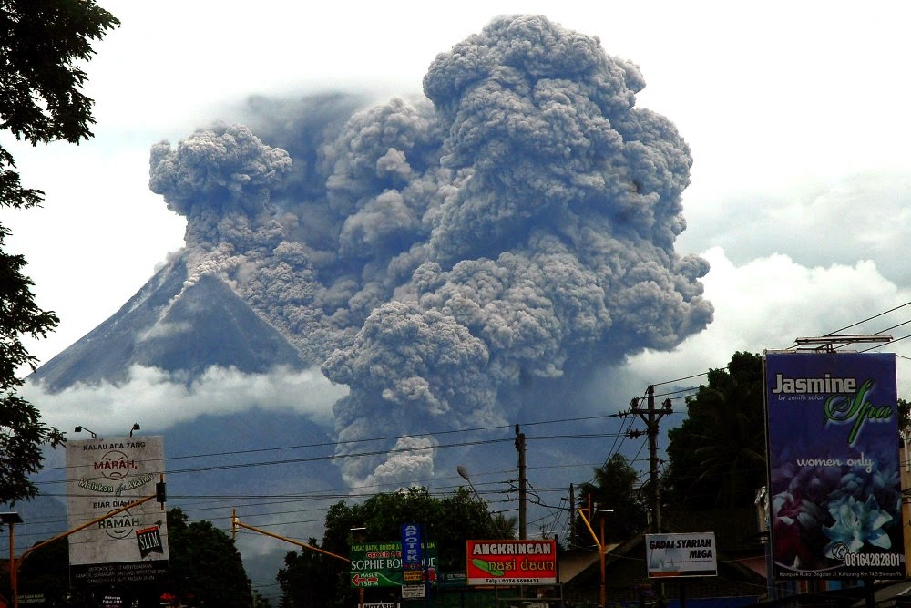
Mount Merapi carrying a freshly build lava dome
For a brief period this was the nation’s capital. During the war of independence (called a ‘police action’ by the Dutch, in an older echo of some current events), Yogyakarta served as the seat of the Republic between 1946 (the fall of Jakarta to the Dutch) until 1948. Indonesia later rewarded the city by granting it a special status. It remains the only city in the country ruled by a monarchy. It is governed by sultan Hamengkubawono X (yes, there have been nine before him) since 1988. In a break with tradition, he has chosen his daughter as his heir. The sultan lives in the Kraton (really!), which here means a walled palace. In this case it is more like a walled city, containing a variety of buildings.
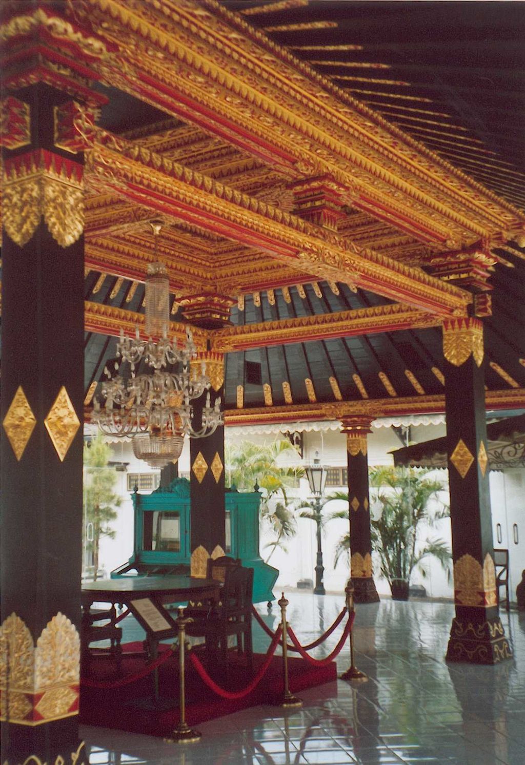
The pavillion in the sultan’s Kraton
Yogyakarta, on the island of Java, is an ancient city. In the 16th and 17th century, it was the seat of a kingdom which ruled much of Java. Long before that, the 8th and 9th century the Mataram kingdom build two magnificent temples here. Nowadays, Lonely Planet calls Yogyakarta ‘the soul of Indonesia’ because of its art and history. The metallic music of the gamelan can be heard: a sacred version is played once a year by the royal family. Gamelan music is among the recordings on board the Voyagers, on their way to the stars: Yogyakarta is where this type of music was first written down.
The two famous temples are Borobudur and Prambanan. Tours can be booked to visit these from Yogyakarta. And so can another famous attraction, often combined in the same tour because it is not far to Java’s most active active volcano. Merapi lies 30 kilometers to the north.

Merapi
At 2910 meters tall, Gunung Merapi is a little smaller than the volcano just to its north, Gunung Merbabu (3140 meters). (Gunung means, not surprisingly, mountain.) The two volcanoes are only 10 kilometers apart, and are connected by a 1500-meters high saddle. Merbabu is considered dormant: there have only been two minor (VEI-2) eruptions in the past 5 centuries. The name is perhaps surprising, in view of this lack of activity: it translates as ‘Mountain of Ash’.

Gunung Merapi is quite a contrast to sleepy Merbabu. The name already gives a hint to its nature: ‘Mountain of Fire’. This is not an uncommon name: there are two other volcanoes in Indonesia with the same name (another Merapi is found at Ijen (also Java) and a volcano called Marapi is an active volcano on Sumatra.) It has minor eruptions every few years, larger ones perhaps once a decade, significant ones perhaps 100 years apart, and a very large eruption 1000 years ago. The lava it produces is basaltic to basaltic andesite.
Merapi is an impressive stratovolcano for tourism, but an uncomfortable neighbour to a major city. It is even more uncomfortable to the many people living closer to it. The land here is fertile and that attracts people. Over a million people live on Merapi’s flanks. During the 2006 eruptions, 200,000 people were evacuated, and in 2010 it was over 400,000 people. In the latter eruption over 350 people were killed when people refused to leave. Merapi was in the original list of decadal volcanoes exactly because it presents a danger to so many people.
In spite of the danger, or maybe because of it, the sultanate is considered have a close spiritual connection to Merapi. The Kraton lies midway between the mountain and the sea: in the local folklore it guards the straight path between the court of the spirits underneath Merapi and the court of the Queen of the South Sea at Parangtritis beach. One side of the main pavilion of the Kraton looks straight north at Gunung Merapi; the other side looks straight south at the Indian ocean. It keeps the balance between the two.

Eruptions follow a typical pattern. A lava dome grows up at or near the summit. After a few years it becomes too big and collapses under gravity. This gives an explosion. The explosion causes pyroclastic flows which raise down the slopes through the drainage channels, often reaching a distance of a few kilometers. Larger explosions reach further. The large eruptions of 2010, 1872 and 1822 were strongly explosive, and the flows went far enough to reach populated areas. The explosions remove the rebuild tip of the mountain. Over the next few year this rebuilds as a new lava dome, and the sequence repeats. Each dome grows in a slightly different location, but alwqys near the summit.
The eruptions also produce lava flows, from the same region as the domes, and typically traveling a few kilometers. Some have reached 10 km from the summit. The pyroclastic flows extend a bit further, with some deposits found as far as 20 kilometers distance. Lahar deposits are found in the valleys: these come from heavy rain, and carry with them the pyroclastic debris. This volcano has history.
Merapi is fed by subduction of the Australia plate. The oceanic plate is still relatively young (120 million years at this location). On top of this subducting plate is a thick layer of sediment. The crust here is continental (Sundaland, part of Eurasia) but is young. This makes the magma more oceanic, basaltic and andesite, compared to the more continental magmas of Sumatra where the crust is older and the eruptions more rhyolitic.

Mount Merapi rising behind the Prambanan temple. Source; Arabsalam, Wikipedia
Merapi is famous for its pyroclastic flows, arising from explosions and from the regular dome collapses. An old description for pyroclastic flows, coined in 1933, is indeed ‘Merapi-type glowing clouds’. (In the Indonesian language (a form of Malay) it is ‘awan panas guguran’ (‘hot cloud fall’): googling this term shows that it is often appears in combination with ‘Merapi’!
Young and Old Merapi
On the southern flank of Merapi there are two steep, eroded hills, Plawangan and Turgo. They are islands of basaltic rock, rising 30 meters above the pyroclastic surroundings. The solid rock are used to advantage, by building the local volcano observatory on Plawangan. It was stable and provided an excellent view of Merapi. There was one drawback: it was a bit too close for comfort. The site was abandoned in the 1990’s because of the danger of the pyroclastic flows. Volcano observatories prefer to observe volcanoes from a safe distance, and preferably from the city it is trying to protect – and its night life.
Both hill date from the earliest know phase of Merapi. They have been dated to approximately 130,000 years. A similar outcrop on the northern flank of Merapi is Bibi, which is slightly younger. These are the remnants of the first volcanic activity known here. It is now know as proto-Merapi.
Around 30,000 years ago a large volcano developed here, probably resembling the current mountain. It is called Old Merapi. It was active volcano. Deposits show that it regularly produced VEI-3 and 4 subplinian eruptions. Very different from the current dome-building-and-collapse events. But the mountain did not survive. Several flank collapses destroyed the mountain. The last one may have been as recent as 5,000 years ago. It left a rim on the north and east side of the current mountain, which is known as Somma Merapi.
The current mountain grew after this final collapse and is therefore known as Young Merapi. Some 6,700 year ago a thick layer of lava was erupted. Around 2,000 years ago the lava composition became more potassium-rich. Since that time, the mountain has been almost continuously active. 90% of all 14C radiocarbon dates obtained for Merapi are from the last 2000 years!

Source Gerttiser et al. 2011, Geology Today
What changed 2000 years ago? The change from explosive eruptions to dome building can come from degassing. Gas-rich magma causes explosions. Gas-poor magma instead forms a dome, and the (milder) explosion comes when this dome collapses. If the magma ascent is slow, gas can escape. If the ascent is fast, it doesn’t. A slow-down 2000 years ago may have led to the current phase. As long as this continues, the mountain is not as unsafe as it could be – something that does put the bar rather low.
Around 1200 years ago there may have been a partial flank collapse of Young Merapi. The size of this is strongly disputed (and the exact date of 1006 you’ll find on wikipedia is wildly optimistic). It damaged the temples in the region and perhaps contributed to the local leadership relocating to a place further east around 928 AD. However, this is far from established.
Dating of the deposits has shown in the past 2000 years there have been two periods of low activity, a short hiatus between 1300 and 1450 AD and a long hiatus from around 600 to 900 AD. After the interruption, the lavas became more evolved (andesitic basalt): during the hiatus, the magma chamber had slightly aged and received little new inflow. The magma chamber is likely small and quite dependent on the amount of inflow.
Dome collapse
Progo Muri fault
A look at the map of Java shows that the central part of the island is much thinner than the easter and western part. It looks like two islands connected by a bridge, and with a thin extension to the east. The four parts are different. West Java has a mountainous volcanic area, the thin centre has two lines of volcanoes running northwest to southeast, East Java has a few isolated volcanoes and the thin extension has the large calderas.
This area is the southeastern edge of Sundaland, the continental block that extends across southeast Asia, Borneo, Sumatra and Java. East Java is part of a separate block, the East Java Terrane, which joined Sundaland a long time ago, in the late Cretaceous, the last days of the dinosaurs.

Along the southern edge is the subducting Australian plate. The subduction is throwing up the volcanic arc running east-west. The plate collision is beginning to affect the region. 10 million years ago. East Java originally was oriented northwest-southeast. The collision and compression caused it to rotate by about 30 degrees, to its current (approximately) east-west orientation.
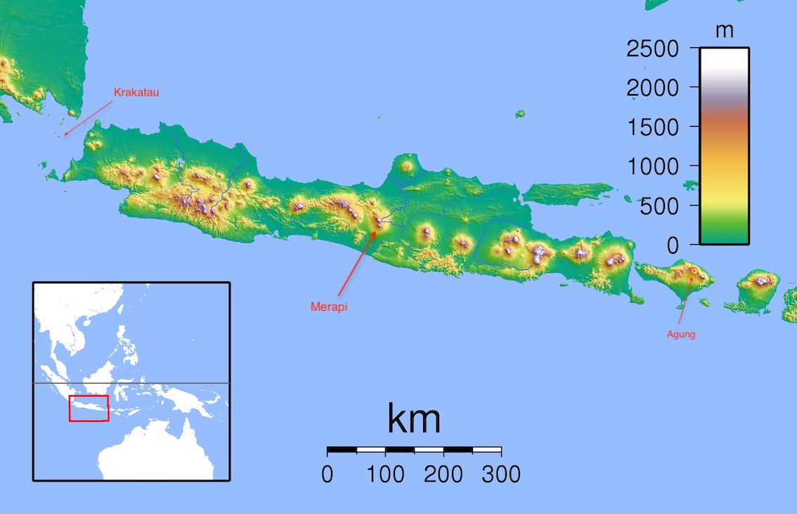
Merapi lies where the central Java connects to the East Java, where the thin meets the wide. The parts are stitched together with a fault, called the Progo Muri fault. (Muri is the volcano that lies isolated at the northwestern top of East Java.) This fault line can be followed from coast to coast, running to theeast of Yogyakarta. The southern part is also known as the Opak river fault: it caused an M6 earthquake in 2006. West of the fault lies the low, fertile basin of Yogyakarta. This basin is caused by extension. It is bordered to the north by the line of volcanoes of which Merapi is the southernmost and youngest member. Merapi lies close to Progo Muri fault line, and has grown up within this extension basin.
A look at how Java is moving under the stress from the approaching Australian plate shows what is going on. The subduction zone around Indonesia is quite strongly curved. It runs south in the Indian ocean, southeast around Sumatra and turns east around Java. This curve puts a torque on the Sunda plate and torques cause rotation.

From Koulali et al. 2017 https://doi.org/10.1016/j.epsl.2016.10.039
The forces are pushing Java to the right (east). This is accommodated by a fault running roughly east-west along the north side of Java. But there is also rotation with east Java moving more southeast and east Java northeast. East Java is still rotating, just like it did 10 million years ago, pushed by the Australian bulldozer. This rotation has activated the ancient connection between the old Sunda plate and the recent (100 million year) addition: the Muria Progo fault. It is a left lateral fault, as expected from the different ways the two sides are moving, but it also has extension as east Java is rotating away from the south side of central Java. This extension has formed a graben, in which Yogyakarta is located.

The line of volcanoes to which Merapi belongs began with Ungaran, followed by Telemoyo, Merbabu and now Merapi. The activity has moved to the south, more into the graben. The extension explains why Merapi can be so active. The old fault line may have helped creating a bit of weakness. Indonesian volcanoes do not need much help, but Merapi is different in that the magma supply to the edifice is continuous, rather than intermittent. An unobstructed conduit is helpful.
Temples
The two magnificent temples, Borobudur and Prambanan, stand strangely isolated. Their abandonment forms part of an old story which talks about an eruption which changed the whole area around Yogyakarta into a wilderness and nearly completed buried Borobudur under ash. The story has been dated to 1006 AD, which is where the data in Wikipedia comes from. However, there is only one deposit around Merapi which could correspond, but it seen mainly in one valley and it is a bit older, by about a century. Oral traditions need to be taken with some caution. The most recent larger collapse is at least 1500 years old.
The temples in Central Java were build in the period 720 to 928AD. The dates are fairly well known because of stone inscriptions. After 850 AD only smaller temples were build but the building itself continued. At the end of the period, the local culture (called Mataram) suddenly relocated to east Java, palace and all. Was this because of Merapi? Some temples were abandoned, whilst other remained in some kind of use until a few centuries later.

Borobudur
Borobudur is still the world’s largest Buddhist temple; Prambanan remains the largest Hindu temple in Java. Construction at Borobudur began around 760 AD. In 780 AD Buddhism arrived and the construction changed character. Later Hinduism arrived but this had little effect on the building which continued until around 850. After this, major building ceased in the area. Smaller temples were quickly (and basically) finished. In 928 the ruling family moved the east Java. Some of the local temples were maintained until around 1260 when volcanic ash began to collect inside the Sambisari and Kedulan temples. This is very close to the massive (VEI-7) Rinjani eruption, and one wonders whether the aftermath of this eruption depopulated the area.
Borobudur was lost after this time. When Europeans arrived, it was hidden in deep jungle. The temple is build on a small hill. It appears that the surrounding area became a lake somewhere around 1200 AD. The most likely cause was river damming by a debris flow or lahar. The lake remained for some time and may be the reason the site was forgotten. It now stands as an impressive memory of an ancient civilization, proving the basic error of colonization, that the locals were ‘savages’ who need civilized oversight. In reality, their buildings were on par with the rest of the early medieval world, whether Europe, America or the forgotten empires of dark Africa. Perhaps the best comparison is young Angkor Wat, a larger area but smaller structure than Borobudur. They show us worlds of which the very existence was denied for far too long.
Prambanan was build along the Opak river. That caused two problems. The river could bring lahars: to secure the temple, the river was shifted further away. The second problem was that this river follows a fault line. Prambanan was eventually destroyed by an earthquake. But by that time it had long been abandoned, when the rulers left in 928 AD. Exactly why they left is still a matter of speculation. A major eruption from Merapi did not really happen and would not have been enough for such a drastic decision. But the region had perhaps become impoverished as suggested by the limited building work. Did the ruling family move because they could no longer afford the maintenance? Without them, people kept at least some of the temples clean and operating, but not forever. In the 15th century Islam took over, but by that time the temples had already been forgotten.

Prambanan (wikipedia)
Building your major temples so close to Merapi was always going to be a problem. Often the pyroclastic flows would run down only a few kilometers from the summit. But every now and then they would reach much further, leaving thick lahar deposits even near Yogyakarta. Temples build too close were buried and eventually abandoned. Even majestic Borobudur would succumb to the mountain. Now the temples of Borobudur and Prambanan are visible again. But Merapi is still there and the danger remains.
Digging down, there are two ash layers in the Borobudur region which exceed anything modern Merapi has done. The layers are more than ten meters thick, and are dated to 120,000 and 30,000 years ago. The younger layer may come from proto-Merapi. Clearly, such an eruption would destroy both the temple and Yogyakarta. No major eruption has occurred in the past 10,000 years: the change in eruption style as helped. But what happened twice will happen again, although hopefully not for a very long time.
And the volcanoes threaten in different ways. In the large 2010 eruption, Borobudur was covered in ash. Prambana escaped, but was covered four years later by ash from Kelud. The acid in the ash is damaging to the stone and erodes the intricate stone work. During the 2020 eruption of Merapi, the statues (stupas) were covered in plastic in order to safeguard against the acidic ash.
Earthquakes remain a danger. Borobudur contains more than 500 Buddha statues. Of those, 200 were headless, lost during earthquakes. The neck is a weakness in these statues.
I wonder though whether the biggest danger is not from Merapi. Indonesia has had two VEI-7 eruptions in the past millennium, from Rinjani and Tambora. The Rinjani eruption appears to be at the time Borobudur was finally abandoned. Perhaps we are safeguarding these monuments against the wrong volcanoes. And it is not just the monuments. Cities like Yogyakarta with its living culture and ancient history are treasures. We should not lose them. Not even to a volcano.
Albert, October 2022

Traditional batik of Merapi and Merbabu above the agricultural fields. Source Troll et al 2015 https://doi.org/10.1111/geoa.12099


Interesting article about Merapi. Kudos to Albert!
But having said that, different volcanoes in different parts of the world seem to be more news worthy at this moment in time.
Thanks Albert! I’ve had a quick scan with intention to come back and digest later, as I’ve been doing other things.
Just putting this down though, a northern cousin of Merapi looks like she’s getting excitable.
Trident 24 hour webicorder
Quite a big jump in activity in the last 6 hours. I think it is notable because the history of this Alaskan volcano is 7 VEI 3 eruptions in 12 years up to 1974, then nothing since for nearly fifty years. Might be ready for a big one.
Erupts high silica andesite, and definitely a significant magma network feeding all those adjacent edifices.
Capable of a big one.
Trident is mostly effusive, so probably more likely to be that way again. Most of the volcanoes in Katmai NP are effusive actually. But then Novarupta is there too so I guess you cant be too sure.
At least, I cant think of a safer place to have a VEI 4+ eruption, dense mou tainous terrain far away from inhabited area. Even Novarupta was not even really noticed exactly for a long time, and I have a suspicion that was a lot bigger than we are likely to see from Trident. Only big problem is to air traffic probably, but that is a well known threat with preparations.
We will also get to see the birth of a new stratovolcano 🙂
Those temples are impressive, like giant stone Cornettos. Do they contain any Crystal skulls?
Given the graben and the rotational forces at work, I wonder if, on some distant date, Java will have split in two and there’ll be a second Sunda-like strait right through that area, and Merapi will have become an island, a second Krakatoa?
Excellent article Albert! Enjoyed this quite a bit.
It still boggles my mind that the two (for certain) VEI 7 events of the past millennium were next-door neighbors. One would think the odds of that to be highly improbable, and yet it happened.
Also always fascinated by volcanoes that carry the, err, “remnants” of their relatives with them. Was ‘Old Merapi’ a larger volcano than present day Merapi, and does that imply Merapi will continue to grow (or does the different magma chemistry nowadays make it more likely to hit a wall in growth before it has a collapse event or otherwise major facade altering blowout)?
Also seems rather ominous looking at Gunung Agung with the massive caldera to its west and Rinjani not so distant to the east. Assuming it will eventually share a similar fate, though hopefully not too soon.
I sure would love to bear witness to a true VEI 7 event though, maybe if we could pluck Agung up and drop it in the middle of the Pacific but set up lots of webcams at varying distances… Goodness I’m Jesperizing.
There is a cluster of volcanoes which have a capability to dwarf Agung that are already sitting in the middle of the Pacific 🙂
Perhaps it is lucky plume tholeiite basalt has a low volatile content or Hawaii would be a very different place…
Although to be fair some of the Pleistocene Hilina formation that makes up the cliffs on the south flank of Kilauea, it does look like a layered ignimbrite/flood lava formation and this area is nearly 30 km from the current caldera… That along with the thick layers of ash making up the Pahala Ash formation which blanket the sides of Maun Loa to meters thick at South Point.
I feel like I’ve heard about ignimbrite activity in Kilauea’s past before, probably from a past comment of yours. I’m going to look into this a bit because it’s genuinely fascinating.
What is the thinking on the behavior / activity there, a scaled up version of something like 1790?
It is only a theory, based on my observation but with no proof as far as I know. It is only really based on reading that the formation is made of layered ash and lava, but I cant remember the exact source for that quote now.
Hector probably has some more info. My main hypothesis comes from his idea that the Kaoiki pali and Koae fault zone is a caldera fault, which seems plausible, and that therefor the magma system of Kilauea is that big or at least it has been that big. Big magma system would mean big eruptions, and the area in question is twice as big as the caldera of Sierra Negra, which is the biggest basaltic magma chamber right now and capable of fast eruptions over 1 km3 from its summit area.
It may just mean that old Merapi was not at exactly the same location. The Somma is seen north and east, not on the other side. It is always hard to tell the size of a non-existing mountain! My guess is that Merapi will not grow much more.
Thanks.
One thing that really stuck with me was how Fuji hides its ancestors within like a matryoshka doll. I think generally the morphological changes that volcanoes go through often in relatively short periods of time is one of the most fascinating parts of all this. I often imagine what various edifices looked like to our distant ancestors, knowing how quickly and violently they can be altered in the blink of an eye. Also of course how quickly they can build from nothing into a mountain.
If I had a time machine, I’d go back to view what Vesuvius looked like before 79AD (and before the Avellino eruption too). Of course Tambora and Rinjani too. What about Hekla before and after 1104? I could get lost daydreaming of this stuff for hours.
I was on Vesuvius in June. Quite a hike. Unfortunately the best we can do for the pre-79AD edifice is that stylized painting from Pompeii. I’m still confused as to whether Somma is the remnant from 79AD or did it underly a later edifice whjch was destroyed. It is said that the pre-79 elevation was 6000 ft. Thoughts?
I have the same questions. I feel like some sources suggest that the somma was the remnant of 79AD, others I feel imply an earlier formation. Visually it certainly looks like it came form a moderately large VEI 5 event.
So much of the Vesuvius artwork I’ve seen from back then is hyper-stylized too, which I thought made it difficult to parse what the actual volcano would’ve looked like in reality.
It’s been a while since I’ve read the VC Vesuvius articles and I’m pretty sure this uncertainty was covered in one of them. I’ll probably revisit because it’s always fascinated me.
Now have read through Albert’s excellent article I’m thinking Yogyakarta is a sister city of Naples. Fertile plains would have been irresistible to the early farmers and one thing led to another. Next minute there’s a city beside a volcano.
That is maybe not a bad comparison! I loved Naples
From memory I think its generally considered that the khmer empire (ie Angkor Wat) spread all along the archipelago probably not under its direct control, but royal offshoots who set their own mini-states up (rather like greece). Then the transition from buddhism to hinduism and isolation all makes more sense. The style of building certainly suggests close contacts.
Thank you for this. In 2010 I been corresponding with fellow who lives on Java and who grandparents were living in the Merapi ‘neighborhood’ at the time of that year’s event. The was concern but no loss.
https://www.britishpathe.com/video/VLVA83LSLDBCFMFP3QOXWOXMUAJ41-FLIGHT-OVER-KILAUEA-VOLCANO/query/VOLCANO
Found this footage of flight over Halemaumau back in 1924. Pretty much accidentally stumbled upon it, so enjoy.
PS great article about Merapi and its history.
Thanks for sharing. Wonder how long after the date of this footage, the steam blast eruption occurred?
To be honest, no clue. I kinda knew that Kīlauea had a lava lake before that eruption, but I don’t even have a clue how long ago. My guess is that this might be in the late 1910’s.
I noticed, at 00:41 in that clip at the top, there seems to be a really shallow crater near the younger Halemaumau. Is it a earlier pit crater or something else?
If this dates from after 1918 then that feature might be a vent, there was apparently an eruption of another vent on the caldera floor that year called ‘postal rift’ but data on where that actually was is nonexistant, and all the lava of that year was buried by more lava the year later. Even HVO has no map of the location…
Mauna Iki formed following this caldera activity, which lead to the lake falling and the crater getting wider. The crater drained out a few times in the early 1920s and overflowed again in 1921 though so this footage could be anywhere from 1919 to 1924. My guess is some time in 1919 before the overflow that year.
It might just be a random formation of two a’a flows that coinvidently made that shape though… 🙂
Might be that because when i looked closer to that shallow feature, it looked somewhat roughly like a bowl-like depression and if you look a little closer there seems to be a crack extending from the feature to the platform nearby. Matter of fact, it looked like the ground only sunk there but not to the point of collapse. Quite interesting, though.
Here’s another photo of that feature. Might have been a marooned lava island, or a rare flow of a’a’ in the caldera: https://earthobservatory.nasa.gov/images/6090/kilauea-caldera
Are you sure if this is the right picture? I clicked on it and seems to be a satellite view of the caldera in 2003.
Yeah, look at about 1 O’clock from Halemaumau, that black area that looks like Gorbachev’s forehead…
On that note, that feature would’ve been gone during the 1924 eruptions on Kīlauea, which expanded Halemaumau.
Also, on that 00:23 to 00:26 mark, there is a crack nearly parallel to the crater edge that has a bit of “fresh” lava on there. I think they might be there before the formation of the crater. Matter of fact, it might’ve done it at least twice due to a ledge with a separated piece on top is there, maybe indicating the previous lava lake level before the most recent collapse before 1924.
The lake went up and down many times in the decades between its formation and destruction. Usually that era is simplified as a ‘100 years eruption’ but actually the eruption lasted from about 1800 to 1892 or thereabouts, at least it began well before 1823 when it was first observed, likely at least 10 years earlier based on filling afterwards. Between 1892 and the 1910s the lake was episodic and mostly absent, by modern definition the eruption was not continuous through this time. It picked up again not long before HVO was founded.
I think there were something like 15 filling and collapse events of Halemaumau that happened in that time, with 1919 and 1921 being big, then 1924 which was probably a failed caldera collapse. If I was to guess this footage is between 1919 and 1924.
That photo is 10 months before I visited there in 2003. Walked from the parking lot at the bottom of the photo out to the wooden fence at the Overlook to pay my respects and make my farewells with Pele. All gone now.
https://www.usgs.gov/media/images/k-laueas-old-faithful-a-thing-past-0
Found thus old map of Halemaumau in July 1909. At the area near this mystery crater of the 00:41 second mark is an area marked “Cone”. Could there be an older cone that got buried by lava?
That feature that called your attention, I think must be the “New Lake”, which was a smaller crater to the east of Halema’uma’u, and that given its name must have hosted a lava lake. I found it on this map from 1896:
Interesting there is what looks like a fissure at the old sulfur banks, same area as the 1970s eruptions. There was the eruption of 1877 that reportedly happened in Keanakako’i although more recent analysis has been uncertain on that, at least there was an eruption in Kilauea Iki that year too. Maybe some time around then was an eruption on the caldera floor which was mistaken for an eruption at Keanakako’i?
Speaking of which there is a bit of a pick up of quakes at Kilauea again, and the lake has resumed rising after sitting flat for the past few days, I think 375m depth might be a limit and another intrusion will happen soon. There has been a little cluster of quakes at Keanakako’i too.
The map I posted earlier is actually from 1886. And here is a map from 1888 showing the same feature, the New Lake.
There was a summit collapse in June 1886, there were earthquakes felt at the summit and cracks opened in Kilauea Iki. It was likely a Kilauea Iki dike intrusion. The Halema’uma’u lava lake drained. I’m guessing that it was also at this time when the New Lake drained leaving a smaller pit next to Halema’uma’u.
It can be seen that within two years the 1886 collapse was almost filled in and that lava was flowing into the New Lake pit, compare the 1886 and 1888 maps. There was a massive floating cone of spatter within the Halema’uma’u lava lake in 1888, which as I have written down in a word of mine went down during the next draining of Halema’uma’u, in 1891, during a SWRZ intrusion. Apparently the New Lake pit still survived in 1924, although almost entirely filled with lava.
That is quite interesting, but I am particularly interested in the feature in the 1888 map called Dana Lake.
Now, I did a bit of my own little research by comparing the frames in the video and comparing them to photos of Halemaumau before the 2018 eruption.
I think that this feature, maybe the Dana Lake crater, about north or northwest of Halemaumau, which meant the camera is angled to the NW. I could be wrong, but I am somewhat convinced (even though I am stuck staring at the mystery of an seemingly insignificant feature).
The Dana Lake must have been destroyed in 1891 though, together with the floating mass in the centre. The Dana Lake was just an opening of the Halema’uma’u lake. It is part of the circular area that collapsed and filled in repeatedly.
Indeed the Dana Lake was swallowed up by the 1891 draining, because in 1892 it was no more.
These maps come from the following link which is a nice summary of lava lake activity in 1823-1924:
https://pubs.usgs.gov/pp/1867/b/pp1867b.pdf
Well, it might be another vent, maybe similar that came after the event.
If you look at the 00:18 mark, there is a feature that looks familiar.
Here are the coordinates of that feature:
19.4183849, -155.2865781
Even though they might’ve not survived 2018, there are at least some photos that reference those features.
Since the feature is not likely Dana Lake, could it be some other feature similar as it is in a west or northwest that formed after 1891 but before 1924?
Wait, I think I might’ve found something based on the maps of the 1891 event. When I looked on that map, there that seems to mark some sort of peak at the northernmost area of the “Neo-Halemaumau” area. Maybe it collapsed to form that feature which is partially buried in lava.
Maybe, but there was no other feature other than the New Lake as far as I know that formed a crater next to Halema’uma’u.
Note also that the video you posted shows probably the filling of the 1923 collapse crater, which changed shape substantially with the 1924 collapse (enlarged and deepened). So be careful when comparing to 2018 photos. Features seen in the video may not have survived past the 1924 collapse.
I kinda knew that the feature would be non-exsistant but I was actually looking in the background, where I swa those steps on the Kīlauea caldera walls and kinda figured from there.
https://ibb.co/vYmzRM7
This is what I roughly think Halemaumau looked like at the time of the video. The age of the lava is represented by the darkness of then. The “depression lines” represent the edges or supposed edges of crater walls or cliff edges. The black line represents a crack and the dashed line represents a probable crack leading to the feature.
This is based on what I saw in the video, so this might not be that accurate.
Strangely I was checking a topographic map of 1922 and there is no sign of any pit near Halema’uma’u, maybe they omitted it, but they do show other subtle features like small cones and rock ridges so maybe it just wasn’t there. Also I couldn’t find the pit in an aerial photo of 1954, the only change to the crater floor since 1924 had been the eruption of 1954 lavas, but I doubt these relatively small flows would have completely hidden the pit. Maybe the video is actually from before the 1919 lava lake overflows which could have buried the pit. I still think the New Lake is the most likely option, since I haven’t seen any other mention of a pit near Halema’uma’u.
Oops, I meant *west or northwest of Halemaumau.
https://www.britishpathe.com/video/VLVA4T47AFNTISVUURLGGTK5GEOYO-VOLCANO-MENACES-HAWAIIAN-COUNTRYSIDE/query/VOLCANO+Hawaii
Found a similar but somewhat different view of the Halemaumau crater, this time people are at the edge (really bad idea today).
Pele doesn’t like it when you throw rocks in Her home!
Hmm… maybe that is why Kīlauea had an explosive eruption… 😉
There’s sufficient photo documentation of tourism to the floor of Halemau’mau’ in the early 20th Century. Not so later on.
Probably after 1924 no one wanted to go near it for a long time. There is a video of the eruption in 1961 where people are standing right on the rim at the overlook watching the lava fountains though, and many videos of the time between then and Mauna Ulu stopping, including people standing on Mauna Ulu while it was erupting… so I guess people got over it. I think the lack of such behavior now is as much due to the inaccessibility of most eruptions after 1975 as it is to actual understanding of the danger the SO2 presents.
The best we’ve got to date is the fool who climbed the active cone in Iceland last year. He was fortunately in the wrong place at the right time in that he was able to race ahead of the lava in retreat. Later videos captured a huge outpouring of highly fluid lava which immediately enveloped the entire cone and from which there would have been no escape. Another was videoed on the rim during a quiet period. He then disappeared. This year, on Iceland, two tourists were videoed walking on a very recent flow. VOG is a realistic danger but the aforementioned are the behaviors of mindless primitives, to say the least.
I dont know if the video still exists, but I remember seeing someone climb fissure 8 while it was still in full fury… they were on the far side of that bay next to the cone, which overflowed a lot in the later stages of the eruption when the surges got most powerful. I believe a maximum output of over 2000 m3/s was observed at one point, and the whole area around the cone was flooded with lava when the channel near the vent (20 meters deep and 40 meters wide…) couldnt contain it…
I think someone also climbed Holuhraun when it was erupting too… I am actually surprised no one has tried to climb down to the lake at Kilauea, I guess steep cliffs are more scary than lava.
We went to Hawaii in 1972, and I remember standing with a large crowd of people right at the edge of the lava lake, looking down at the bubbling lava. It was so hot that you could only look at it for a few seconds at a time.
Quite recent, that. I would have thought HVNP would have prohibited close encounters at that date.
https://www.britishpathe.com/video/VLVA19JK3UPQ0E87ZWHYZYH7SXE8N-USA-ERUPTION-OF-HAWAIIS-KILAUEA-VOLCANO/query/hawaii+volcano
Another clip featuring an eruption somewhere on Kīlauea (no idea where, looked up Wiki (source questionable) and the last of the rift eruptions occurred on August 25, 1923. Could be wrong.)
The first part is Kilauea, in 1924 and some point earlier. The lava in the village is from Mauna Loa probably in 1926 or maybe 1919.
Looks like Stromboli is starting a little show https://twitter.com/Flash_news_ua/status/1579207329043877888
Love the comments!
Here is a video of the lava flowing into Tyrrhenian Sea :
https://video.repubblica.it/edizione/palermo/stromboli-la-lava-cade-a-picco-nel-mare-le-impressionanti-immagini-dal-drone/428810/429764?ref=RHTP-BS-I367295185-P7-S3-T1
stefano
I am a fan of gemelan orchestras Geo.
Especially the pieces starting with ritme and several music lines are woven together, played at the same time.
Love it!
There’s an ongoing jökulhlaup in Grímsvötn. The water level is currently low, since the lake drained last time less then a year ago, so the flow is expected to be only one fifth of that last year.
https://www.vedur.is/um-vi/frettir/litid-hlaup-ur-grimsvotnum
Why is there a jokulhaup?
We know that it’s probably close to an eruption by now, so maybe the geothermal output power is too high for the ice dam to recover after last year’s hlaup. I also think the reasoning that a jökulhlaup can trigger an eruption is all backwards. Instead, it wouldn’t surprise me if it’s the increased geothermal output prior to an eruption that triggers the jökulhlaup.
A week ago the Grimsfjall highpass graph was showing tornillo (screw) shaped signals.
These signals are not common and likely are caused by magma flow/increasing pressure in the magma chamber. It was a short living period, seen before last year I think.
Surface temperature could be rising as a result of the expanding chamber more and more.
Grimsfjall eathquake graph 3 oktober

Source IMO
Grr. Thats a bit obscure.
This is better?
They have officially updated the aviation code to yellow as a response.
It’d better erupt this time!!!
My wife and I will be in Iceland in 12 days…
Being there for a Grimsvotn eruption? Now that would be a good way to celebrate our ten year wedding anniversary.
For non Icelandic speakers convenience…
Google translated
“”small run from Grímsvatn
Maximum flow in Gígjukvísl predicted for Wednesday. Increased chance of eruption following a run.
10.10.2022
Measurements by the Geosciences Institute of the University of Iceland indicate that water is beginning to flow from Grímsvätni and a flow is expected in Gígjukvísl. The ice sheet has receded by almost 3m in the last few days, but the water level is low in Grímsvatten, so a small run is expected, or almost a fifth of the last run. It is most likely that the race will take place in Gígjukvísl tomorrow, Tuesday, and last for several days. It is believed that if the waters completely drain, the ice shelf can sink by 10-15m in total.
The last run from Grímsvatn was in December last year, so it’s been a short time since the last run. Measurements of the water level in Grímsvatten indicate that the maximum flow of the stream now will be low, around 500 m3/s, but last year the flow reached almost 3,000 m3/s. That run had little or no effect on structures, e.g. roads and bridges.
Closely monitor activity in the fire station
There are examples of volcanic eruptions in Grímsvatten after water flows from there. It is believed that sudden pressure relief due to falling water level triggers eruptions. The last time such a scenario happened was in 2004, and before that in 1934 and 1922. However, Grímsvatten has run out much more often without an eruption. However, the flight color code for Grímsvötn has been changed to yellow due to the run, as it is difficult to rule out the possibility that an eruption will start as a result, although it is considered unlikely. Two things need to happen; pressure relief has to be enough “gikker” to wake up the volcano, and pressure in the volcano has to be enough to trigger an eruption, but there is uncertainty about both aspects. The greatest pressure relief in Grímsvatn can be expected on Wednesday, when the run reaches its peak, and with it an increased chance of an eruption, which will quickly dwindle after the run.
The Norwegian Meteorological Agency together with the scientists of the University’s Institute of Geosciences continue to monitor Grímsvatten and will publish information depending on the development of the scenario. In light of this, it is worth pointing out that along with glacial runoff gas pollution can be expected, which will be greatest near the glacier edge and at the riverbed of Gígjukvíslar.
More about the volcano Grímsvätn
Grímsvätn is the most active main volcano in Iceland, where during periods of activity, as it has been since 1996, it is common for 5-10 years between eruptions. About 20 eruptions have occurred in Grímsvatten and the surrounding area in the last 200 years. The last eruption in Grímsvatten was in 2011 and it was quite large and powerful, but otherwise the last few eruptions have been rather small and lasted for a few days. More information about the volcano can be found in the Icelandic volcanoes website.””
Here is the tremor plot from Grims seismic station that shows the elevated tremor.
Source graph IMO.

Note that the tremor peak seen is the large storm that passed over Iceland during Sunday. Look instead at the lowest part of the blue curve and notice how it ramps up starting from Oct 8 – that’s the signal of the jökulhlaup. It bounds the tremor plot from below rather than show up as a peak signal.
I noticed the storm, but didn’t recognize it in the graph.
Thanks for commenting!
Got a bit of a competition then, will Grimsvotn erupt or Kilauea. I guess Kilauea is already erupting, but it looks close to doing something new now.
Not exactly a lot, but it is noticeable and there is about the same layout of quakes as there was before the intrusion a few weeks ago. The lake will get to 375 meters deep again in a week or two, which is where it drained last time. There is no cluster of quakes next to Kaoiki pali like there was in September but there is one at Keanakako’i.
HVO has modeled the intrusion as a sill not a dike, so unlike a dike which can close again a sill pretty much is a permanent change, as evident that the deformation data all went up but not back down. It also means the new sill is probably still active and may resume moving with enough prrssure. I think we will see a SWRZ eruption soon.
I guess Grimsvotn will just happen, most basaltic calderas and fissure volcanoes erupt very suddenly, Hekla is infamous for this but it is hardly unique. Grimsvotn is a caldera but it mostly erupts from the same fissure on the south edge, so it is sort of a fissure volcano too. So probably there will be strong tremor and then eruption in the span of a few hours, starting from nothing unusual. Like how Kilauea began its last two eruptions only there is a lot of ice in the way in this case 🙂
Unlikely but it could be interesting if the eruption begins on the exposed wall of the caldera where there is no ice.
Yes, Grímsvötn just goes off when it erupts. Last eruption in 2011 started with strong tremor at 17:30 on May 21. There was a strong earthquake swarm as well, but that started almost 30 minutes later. At about 19:00 the eruption broke through the ice.
Is Greip still a thing? Or was it identified as a feeder chamber to Barda/Grimsvotn?
It is still there. Activity is low at that spot now.
I don’t believe in a connection to an exsisting central volcano.
I think it is a feeder in building stage. At the northern end of the Þórðarhyrna – Grimsvotn fissure system.
Perhaps it is why it takes Grims that long this time, it is eating magma. Pure speculation! 😄
Meant as reply to Andy.
I think Greip might become a new shield in the future when Vatnajokull melts, whether it then evolves into a new polygenetic volcano or stays as a shield is less clear. Big fissure eruptions come from magma chambers draining, but they dont usually last long. Shields last for years, perhaps as long as centuries in some cases, and have an upper volume that is way bigger than even the biggest fissure eruptions, 30+ km3 in Iceland and maybe even bigger for some in Hawaii.
Grimsvotn has an open system below uts magma chamber, but a closed lid. It is more like a Galapagos caldera than it is like Kilauea with an open vent. It might be hard to form an open conduit in that configuration. But a new volcano would not have that problem so just overflows for ages until then.
I am quite curious about the update on the so-called “Kilimanjaro mystery” as noted here:
https://www.volcanocafe.org/the-gentle-giant-of-africa/
Is the mystery solved or did it deepen?
Not sure if it has anything to do with that article, but GVP now no longer lists Kilimanjaro as active and says recent research puts the youngest samples as over 0.1 mya, or 100,000 years ago. Basically the pristine appearence of the summit is because it cant erode easily, only ice and not much of it to do anything at that altitude.
Grimsvotn: will it erupt today? If not, we might have to wait another year and Askja might get their first!
I think Fagradalsfjall will have more eruptions before then. About every 3 months there is an intrusion somewhere in that part of Reykjanes, so we can expect another one in October, which is now… 🙂
There is a bit of tension showing there actually, along the main fault it is clearly highlighted by quakes, which is what happened before the last few intrusions and largely stopped immediately following them. If the next intrusion is at Fagradalsfjall again then I think it will erupt again.
But in saying this, there is a better chance of Grimsvotn erupting in the immediate future than another eruption on Reykjanes.
My wife and I are leaving for Iceland on the 23rd (came fast, wow)!
I believe we’re planning to do the Fagradalsfjall hike on the 27th, weather permitting of course. I plan to take good pics and videos of the lava field, hoping to get a nice birds eye view from on top of the plateau. Will definitely share anything interesting.
Any not obvious safety concerns going out there? Definitely won’t be stepping foot on any of the flow field.
I would think the flow field from last year should be fairly safe – just follow the local information from the various official organisations. This year’s flow field may be a different matter! The main issue in Iceland tends to be the weather, and especially the wind. It can change very rapidly and before you know there are sheep flying around (in-joke). Weather permitting, it should be a very interesting trip!
Thank you Albert!
How long are you in Iceland for? If yiu are there only a week maybe it is a low chance of seeing an eruption but better now than most other times 🙂
There was a star at Krysuvik the other day, not much on its own but shows there is tension building again in the area. I think there will be another intrusion on Reykjanes in the next few weeks, probably another eruption if it is at Fagradalsfjall again.
We’ll be coming home the 6th of November, nice and long trip!
I’ll be reading VC every night still and definitely staying on top of the seismic activity while we’re there. One never knows!
Talking about Grimsvotn… why not Hekla?
I have just been looking at the tremor measurements… there is a station called hesthals, which I think is by Hekla… it has started doing some funny things….
The drumplot looks a bit like there might be an instrument problem. None of the nearby stations show anything similar, so I don’t think it’s time to start digging out Hekla webcams just yet.
Isn’t Hesthals near Reykjavik? I can never find half these stations in Iceland!
Here’s a great resource.
https://vafri.is/quake/
It’s in icelandic, so might take a bit of work to get used to. If you go to the menu ‘Kort’ (icelandic for map) and tick the option ‘Skjálftamælar’. This will show markers for all the seismometers. Click one and it will show the name, tremor plot and the highpass and lowpass drumplots.
Neat!!
Thank you Tomas.
Some observations from Mauna Loa over the past couple days:
EQs are medium-high, no mag4+ bellringers yet. Seem to be lining up with the 1933/40/49/75/84 fissures as expected.
More interesting are where the EQs *aren’t* happening–nothing further down the SWRZ than Lua Hou, nothing outside the North Bay on the NERZ. I’m not going to speculate on what this means because the glaring problem is that we’re spoiled from Kilauea’s activity that it’s hard to make educated guesses based on the state-of-the-art at the time data from 40-50 years ago! I know that some seismology researchers back the current data quality and quantity down to 1975-84 levels of reporting and then compare–I’m sure HVO is doing this.
Mauna Loa has no connected rift storage, just one large magma body in its general summit area, rift eruptions are long dikes like they are in Iceland, and of similar scale.
Kilauea has active connected magma storage along most of the subaerial ERZ, so basically its magma system goes almost as far east as Leilani Estates. Most eruptions there are smaller dikes so its eruptions are rarely as large or intense as Mauna Loa. But sometimes large rifts do open on Kilauea, sometimes far east like in 2018 other times the whole southflank, like in 1840 or maybe 1924. Those eruptions do have intensity of Mauna Loa eruptions and are often larger, so not exactly correct to say Mauna Loa is always bigger we all found out a few years ago.
Thing is though the current seismic area on Mauna Loa basically is its entire summit system, so it is an indication the volcano is under pressure, like we see when the rift conduits of Kilauea flare up. I think it is at the limit… Summit eruption only is most likely.
Philip Ong says much the same on Hawai’i Tracker: “…Most likely, Maunaloa’s next eruption will start and end at its summit, as was the case in 48% of historical eruptions…Historically, following at least one year after such an event, a MLSWR eruption becomes more probable…”
I think that is the case of NERZ eruptions, that they are begun by an eruption in Mokuaweoweo. SWRZ eruptions might not though, they seem to begin at the pit craters not in Mokuaweoweo. Radial eccentric vents might also be like this, without an immediate summit eruption as a precursor, only 1859 is observed though so might be hard to tell. I think a lot of the SWRZ eruptions are preceded by a summit only eruption a bit further back though, like 1949 to 1950, or 1915 to 1916 and 1919. 1926 seems to have been alone though.
I guess in this case 1975 actually probably should be considered as a NERZ eruption, given there was a large intrusion down that rift which I am not aware of happening in other summit eruptions, which were mostly restricted to the southwest caldera floor. Its a bit of a grey area though as the actual vents are all within the summit elevation contour.
https://twitter.com/Sjonni_KAUST/status/1580412245661536256
Iceland grows by almost 2 cm/year – visible from space! Here is our average east ground velocity from Sentinel-1 (w.r.t. Eurasia) clearly showing the plate-boundary location. Details in @yunmengCao
‘s JGR submission:
Note the different pattern around Askja.
some of it is removed by different coloring scheme. Fascinating thread!
But the caldera does not want to go West in both?
https://twitter.com/fcrameri/status/1580452338615353344
these are the comments about coloring scheme.
Interesting comments on the colour scale. The scale makes it look like the plate boundary is much sharper than it really is because the contrast between orange and green is much stronger and over a smaller range, than the contrast between different tones of blue or red. I guess grayscale is among the best colours schemes in showing variation in a more even manner, although experts in this matter might know better me.
yes, Askja seems stuck in place. The data are from 2015 to 2021. I guess if Askja deflated during that time (post Holuhraun) that could explain the pattern.
I find it interesting that the plate boundary goes through Grimsvotn, Bardarbunga, Hekla, Grimsnes, and finally reaches Hengill and Brennisteinsfjoll. So Hekla, and Grimsvotn, and Grimsnes, are actually plate boundary volcanoes, not really off-rift volcanoes like may seem from the topography of Iceland. I expect that in the past the plate boundary went through Langjokull and Hofsjokull, and that is why those areas are so elevated, have old tindars (subglacial fissures), and have central volcanoes that are no longer very active.
Also interesting to note that spreading has been faster in Reykjanes due to the magmatic and seismic events there.
The more I look at the picture, the more confusing I find it.
To interpret these color maps is tricky, for example try to follow the zero ‘line’ across the island. Where greenish becomes blueish. Askja is not on it. Bardabunga? Btw is the 0 line par se the plate boundary? Or could it be the -10 line as well when one plate moves faster than the other.
The plate boundary looks much more confuse as I expected. Would be nice to draw lines, as in a isohypse- / contour weathermap. But the placed lines at some spots, as the in northeast of iceland, would be arbitrary.
It is a 6 years data combination, bit short period 😉.
The northwest part of Barda is dark, ‘shadowing effect’ may play a role, as can be seen on the entire map. The gps station Kista (northwest slope Barda) has been moving relatively fast northwest since 2014 though, so the dark part isn’t just shadow there. Interesting how fast Barda and Kverkfjoll has been moving away from eachother. Action area!
Between Kverkfjoll and Bardarbunga is the rift zone that Holuhraun formed in, presumably was still moving until inflation resumed at Bardarbunga over 6 months after the eruption ended, September 2015 I think. Inflation probably resumed as a secondary effect of the rift stopping now that I think about it. So should still have been moving for a bit of this INSAR interval. If the interval began a year earlier I think that whole area would have looked like Reykjanes does in the bottom left.
As a side note on that, it is also pretty clear that Reykjanes movement is not only at the location of Fagradalsfjall but all of it, Fagradalsfjall is only the tip of the iceberg…
what do the small circles indicate ?
Is something happening at Oraefajokull?? VD is reporting an eruption but I know they’re not the best source and I can’t find anything else on it.
This is pretty clear:
https://www.volcanodiscovery.com/oeraefajoekull/news/194319/Oeraefajoekull-Volcano-Volcanic-Ash-Advisory-ASH-RICH-PLUME-VISIBLE-OBS-VA-DTG-140900Z-to-20000-ft-6.html
Status: EXER says it all…
It’s just an exercise. VD are just not clever enough to realize that. I’ve lost count on how many times they have reported Icelandic exercises as real eruptions…
Amazing….
Thank you for the heads up. I figured each passing minute it went unconfirmed by another visible source it was likely BS.
If Öræfajökull really were to erupt, there would be no doubt about it whatsoever. Volcanocafé and social media would be exploding with comments faster than you could spell jökulhlaup. Albert would probably post a new article about the eruption and its expected consequences quicker than London VAAC could issue a VAA. Vísir would be live streaming the event from a helicopter even before anyone says the word webcam and Carl would be playing lip banjo with his keyboard while Jesper jumps around making Gollum sounds. Basically, we would know.
The very first VAA of the exercise, issued at 08:20, was even more obvious. It has one field that says:
ERUPTION DETAILS: EXERCISE
Comment made my day, LOL!
Indeed, I should’ve realized VC is the ultimate source. With this event having a Jesperization Index Rating of 0, I should’ve known to temper my excitement.
Love this place.
Oraefajokull is one of those volcanoes that tends to erupt pretty big, its not going to leave any ambiguity about whether anything is happening. Most of its eruptions are VEI 4-5, the eruption in 1362 was a VEI 6 and probably the biggest explosive eruption in the historic period of Iceland, so chances are the next eruption will be one of the bigger ones this century there at least a VEI 4, and a real 4 that erupts in a day not a month.
It isnt a rift volcano like most of the other Icelandic volcanoes, it is a stratovolcano, and pretty similar to Pinatubo in also being a small caldera. It is sort of like a more powerful version of Eyjafjallajokull. It also might be really old maybe even the oldest still active single volcano anywhere on Earth given it sits on an ancient section of rift that has been dead for at least a few million years.
Thankfully no eruption, given that it’s a big beast with quite silicic magma containing fluoride, and with a sizeable ice cap to boot.
Don’t really like that VD do this to be honest, been a few times i’ve had a double take when some long dormant volcano apparently has awakened.
The flaws with making alerts automated…
On VD it is an automatic system that reports VAAC alerts and raises the status to orange. I put it back to green as soon as I saw it. I don’t really like the automatic system but it’s not up to me I’m just one of the helpers on the site.
Interesting. I assumed some level of automation had to be involved.
I missed the code that showed it as an exercise, I’ve definitely seen that before.
Chalk it up to the adrenaline of thinking Oraefajokull of all voclanoes was waking up a week before I’m going to be in Iceland.
The alert is obviously parsed and interpreted by VD’s automatic system. It shouldn’t be difficult to add a check for EXERCISE or the short form EXER. I also have issues with VD having its own color status system. I honestly think that’s something better left to official sources.
I mean there are a lot of other volcanoes less likely to erupt, Oraefajokull had intrusions in 2017-2018, it is active. That is much more than can be said of most other Icelandic volcanoes.
Icsland is very interesting, that it is very active overall but individual volcanoes usually arent. It isnt like Hawaii where there is one that is always erupting, there is a bit more uncertainty. Although there are definitely some that are more active than others… Will be interesting to see if the new cycle at Reykjanes leads to a total increase in eruptions or if somewhere else dies down in response or even by coincidence.
I just re-read Carl’s piece here on Oraefajokull and brushed up, was interesting about the recent intrusions and discussions about how it could potentially erupt in the nearish future. Definitely makes sense. Also makes sense why they’re doing mock eruption drills for such a powerful volcano. I know it could theoretically awaken at any time, it’s just the fact that it appeared to be doing so a week before we’re flying out to Iceland for 12 days lol.
I almost text my wife at work, “welp forget the trip!” It was funny in hindsight at least heh.
Kilauea SWRZ is active while the ERZ is quiet… Not sure I have seen this before, even the SWRZ intrusion last year there were ERZ quakes alongside it. There are also more obvious quakes at the summit on the 1 week map that I posted in another comment, the caldera is looking quite lively compared to more than a few weeks ago before the recent intrusion. No Kaoiki quakes that usually signal when magma pressure in Kilauea is increasing, but then Mauna Loa is also active and that area is where the volcanoes interact, so that might not be a reliable variable right now.
It is also a point that the last two eruptions were preceded by intrusions about a few weeks to a month in advance… 🙂
Man, Pahala just went nuts! One 5, at least one 4…
The depth is very shallow for these earthquakes. Most seem less than 13 km deep. It is possible that this is a Hilea Fault Zone earthquake, from the same fault that generated the M 7.9 Great Kau Earthquake of 1868, which runs at 10-12 km deep. Although the mainshock seems to be located at 20 km depth which is a little too much for a Hilea earthquake, it could get corrected later though, after it gets revised. The other earthquakes are likely aftershocks of the M 5 mainshock. I’m not sure if this could trigger a Southwest Rift Zone eruption of Mauna Loa, an M 6 could have done it, but an M 5 is probably small enough not to have a significant effect.
Large earthquakes are not too rare in this particular location. There have been M ~5.6 earthquakes from the same location as the recent earthquake, twice in 1982 (a double event), and once in 1999. There was also a M 5.4 in 1988.
And as I mentioned before this is thought to have been the epicenter of the Great Ka’u Earthquake, before the rupture extended over to Kilauea’s flank and the Kaoiki fault zone. It was also probably the rough epicentral location of an M 6.2 in 1919, and a series of three M 6.1-6.6 earthquakes in 1887.
HVO writes
“This sequence of earthquakes appears to be related to readjustments along the southeast flank of Mauna Loa volcano. There has been no immediate effect on the continuing unrest beneath Mauna Loa summit, which remains elevated at levels similar to the past week. On several occasions large earthquakes have preceded past eruptions of Mauna Loa, though these have typically been larger than today’s earthquakes. It is not known at this time if this sequence of earthquakes is directly related to the ongoing unrest on Mauna Loa. “
I cant help but think these are foreshocks to something more serious though… And all the eruptions you mentioned were in the Ocean View area, compared to 1950 which had a quake in Kona and after the eruption. So quakes in the Hilea area seem to precede distal SWRZ eruptions
It might be just the opposite. These shakes could still be aftershocks from the 1868 M7.9 quake at this location.
Technically until a bigger quake happens though every quake that happens here is an aftershock of the 1868 quake though… I dont think that concept really works in places like Hawaii where the south flank of the island is always moving a little bit and quakes never stop entirely.
Does anyone have a graph to compare to just before the last eruption?

Okay I don’t think it likes gifs
hraun.vedur.is/ja/oroi/grf.gif
It’s really ramping up over the past week, can’t be long now surely
Here is the list of the quakes in the last 2 hours
2022-10-14 20:02:04
Earthquake
Magnitude:2.2M
Depth:1.4mi
2022-10-14 19:58:25
Earthquake
Magnitude:2.2M
Depth:7.2mi
2022-10-14 19:52:28
Earthquake
Magnitude:2.4M
Depth:-0.8mi
2022-10-14 19:47:59
Earthquake
Magnitude:2.8M
Depth:5.5mi
2022-10-14 19:46:53
Earthquake
Magnitude:2.8M
Depth:1mi
2022-10-14 19:42:20
Earthquake
Magnitude:2.5M
Depth:6.2mi
2022-10-14 19:36:22
Earthquake
Magnitude:2.4M
Depth:11.7mi
2022-10-14 19:32:55
Earthquake
Magnitude:2.7M
Depth:0.4mi
2022-10-14 19:31:47
Earthquake
Magnitude:1.9M
Depth:2.2mi
2022-10-14 19:27:28
Earthquake
Magnitude:2.6M
Depth:8mi
2022-10-14 19:23:42
Earthquake
Magnitude:2.9M
Depth:7.8mi
2022-10-14 19:20:13
Earthquake
Magnitude:2.1M
Depth:7mi
2022-10-14 19:16:45
Earthquake
Magnitude:4M
Depth:6.2mi
2022-10-14 19:15:37
Earthquake
Magnitude:2.8M
Depth:7.6mi
Missed a few
2022-10-14 19:07:29
Earthquake
Magnitude:5M
Depth:12.4mi
2022-10-14 19:07:05
Earthquake
Magnitude:4.6M
Depth:8.4mi
Location
Pahala
Note the main shock and swarm is much shallower in depth than typical?
It’s a fortunate/unfortunate coincidence that there are two swarms essentially co-located on two axes but differ in depth by ~25km, and differ in their genesis.
I notice green bubbles on the Kilauea monitoring. These have been rare or small between eruptions and more frequent on eruption. I’ve related it to magma rising in my head, so do we think movement has been triggered?
I asume you mean the green depth quakes on the map? 13-20 km depth.
These quakes I think are too dispersed to be a sign of a big surge right at this moment.
But, this is indeed the depth of long period quakes for Kilauea, the bottom of its magma conduit. This is possibly the bottom of the crust, although I think it is more likely that a large magma body exists under Kilauea that goes from the base of the crust (~20-25 km, probably about where the Pahala quakes are) up to the LP quakes at 15 km.
Those are earthquakes around 15 km depth. Fairly infrequent because the lower crust (lava pile) is pretty robust. They occur across the island. By themselves, a few such events are not significant. A cluster of these underneath a volcano would be more interesting
I would like to read an article on this site about the Esjufjoll volcano someday.
I can’t find much information about it.
This gives about as much info as there is:
https://icelandicvolcanoes.is//?volcano=ESJ#
Because it’s far into the ice cap I imagine it’s quite inaccessible. There isn’t any nearby equipment monitoring it, though I imagine the Icelandic authorities keep a check on the inSar data from time to time.
Thanks for the links.
Indeed Esjufjoll is a volcano with a diameter of 20 kilometers.
Not bad.
It reminds me a lot of an extinct version of the Bardarbunga volcano.
Every now and then I see that micro-earthquakes appear, however based on the data an eruption is estimated every 1000 years.
It would be interesting to see it erupting.
If I was to guess, both it and Oraefajokull are really old, maybe millions of years old and active today only because of a long lived magma system being very open at least at depth. I presume Esjufjoll has a lot of rhyolite too but I havent checked.
But then, there is the question of Esjufjoll really being active, only one confirmed event in historical time, and it is not certain that was actually an eruption. Only something like 1 in 10 jokulhlaups from Grimsvotn are related to eruptions, and its even less at Katla, so chances are not any better at Esjufjoll in all likeliness.
Not sure if this is sugnificant in the long term, it looks like the ERZ of Kilauea is moving. In the past few weeks the stations at Pu’u O’o have moved closer together, the eruption rate at Halemaumau hasbt changed and magma isnt flowing, so this could be due to south flank movement. If this is also happening further west it could allow the flank of Mauna Loa to slip too.
I cant help but wonder if there will be a double eruption soon. Mauna Loa looks set to go, maybe not really soon but there is no doubt. But Kilauea is filling up, rapidly and also looks set to do something, and large quakes on the south flank tend to involve or affect both volcanoes. 1868 saw eruptions from both together. 1919 was not simultaneous but saw a SWRZ eruption at both within the same year, there was also an eruption on Kilaueas SWRZ a few months before Mauna Loa erupted in 1975. It might have been a coincidence that Pu’u O’o was erupting in 1984 but SWRZ eruptions at Kilauea seem to be more related and line up with a Mauna Loa eruption on more than one occasion.
Looks like Katla’s glaciers cracking a bit today, 22 earthquakes so far and mostly at the ice sheet depth.
Think 1.1 and possibly 0.1 may be defaults when they can’t be sure of the depth. But very interesting all the same.
Note that Katla had a wobble, including a 3, a few days before the onset of the swarm at Bardarbunga heralding Holuhraun. So I’d keep an eye on both Myrdalsjöjull and Vatnajökull right now.
New post is up! The rise and fall of Iceland
https://www.volcanocafe.org/icelantic-growing-a-nation/
Albert it says the new post is not found when clicking the link, can you fix this problem please. Thanks in advance😉
No idea what happened there as it was published. It seems to work now
Thanks Albert.