Continental drift was dead. The idea had been around for a long time. Just a cursory look at a map shows the similarity between the coast lines on either side of the Atlantic ocean. They fit even more precisely when looking at the continental shelf rather than the actual coast line. Even better, the geology on either side fits as well, with the Norwegian mountains continuing into the Appalachians. It could be seen elsewhere as well. Madagascar fits snug against the African coast. Western Australia looks very much like South Africa. Fossils on either side of these divides were similar, at least for older species. In some cases, living plants had relatives on the other side. Alfred Wegener wrote this down in 1915, translated into English in 1922. But the idea had a fatal flaw. There was no mechanism to make continents move across the globe. It couldn’t be an external force, and there was no suitable internal force. So continental drift died.
Resurrection came in the 1960’s. Our understanding of the Earth was growing, and the similarities became more and more undeniable. And then the trumpet call came. Stripes of opposite magnetic field directions were found in the rocks on the bottom of the ocean. Each stripe could only date from a time of before a reversal of the Earth’s magnetic field. But that meant that the ocean floor was very different from the continents. It was continuously created. Here was the mechanism that could move continents, one that could create the oceans between them.

And then it died again, or at least metamorphosed. The driving mechanism came in doubt. The convection currents in the mantle seemed unable to move the ocean floor. The friction between the mantle and the oceanic crust, down in the asthenosphere (the ductile layer between the two) was not really high enough. A new driving mechanism was required. This became the oceanic subduction. The oceanic plate sinks down in subduction zones, pulled down by the irresistible force of gravity. It happened naturally when the plate cooled and became denser than the mantle below. It turned out that this pull on the sinking plate was sufficient to get the whole plate to move towards the abyss. It is not the only force in action: mantle convection in the asthenosphere still contributes and gravity also works through the mid-oceanic rifts which around 4 kilometers high so that the whole plate continuously moves downhill, like a reversed Escher drawing. How much of the force comes from each component is still being disputed, especially because there is disagreement on the viscosity of the asthenosphere. But there is general agreement that ‘slab-pull’ on the subducting plate is the largest contributor.

As the oceanic plate begins to subduct, the plate on the other side of the subduction zone will be pulled in to fill the gap. If that plate contains a continent, the continent would find itself being pulled towards the ocean. So now the drift of the continents was nothing else than a side effect of the subduction of an oceanic plate. The name ‘continental drift’ seemed inappropriate, as it focussed on only one and a rather minor aspect. Instead we now call it ‘plate tectonics’. It is no longer limited to the continents: the oceans are by far the more important aspect. School children learn about the plates and can recite their names. The plate edges are easily recognised just by plotting the locations of volcanoes and earthquakes. The ‘ring of fire’ that surrounds the Pacific ocean leaves no doubt about the main mover and shaker of the Earth. All of us dance to the beat of the Pacific plate. The wide stillness of this ocean hides a big power. So the queen of continental drift is dead: long live the king of plate tectonics.
Plates
The Earth contains as many as 70 separate plates. That is rather more than the average school child has to memorize. There are 16 major plates; all the others are platelets and microplates: small bits that survive from previous subductions or have split off from other plates. The most recent addition has been the Malpelo plate, a microplate located between the Galapagos islands and South America. An other addition from the last 20 years has been the Sierra Nevada Microplate. Each plate can move somewhat independently from the surrounding ones.
There is no clear distinction between oceanic plates and continental plates: a single plate can contain both ocean floor and part or all of a continent. The Australian plate is a good example. Plates can also be purely oceanic or purely continental. If a continent rifts, the rift develops into ocean floor, so that what used to be a continental plate now becomes two mixed plates. Plates are not eternal. The boundaries change, parts can change allegiance, a collision can become an annexation, and oceanic plates can disappear completely. Of course where a plate contains a continental and an oceanic part, the oceanic part may begin to subduct and now the two parts will be separated. These linkages tend to be temporary.
The only constants are the continents: they are low density and float on top of the sea of plates, and therefore can’t subduct. Look at the plates from below, and the situation reverses. The continents have deep keels and stick out far below the ocean floor. Some of the keels can be over 100 kilometer deep, while oceanic crust is only around 10 kilometer deep.
The latest map of the Earth’s plates can be found in Hasterock et al, 2022, Earth-Science Reviews, volume 231. The basic map of the major plates is shown below.

The definition of oceanic crust is based on density: it is formed by seafloor spreading which brings up mantle material. This is the reason why the oceanic crust is of similar density to the mantle. Continental crust has much lower density. Oceanic volcanic arcs are an intermediate case: they are formed on top of oceanic crust, but the magma is different (separated) and the volcanic mounts themselves can be considered as continental. When a volcanic arc reaches a subduction zone, the oceanic crust dives down but the mount may survive. It can be added to a continent in this way, making them grow. This was how the first continents began to form.
It can be difficult to give an exact location for a plate boundary. Often there is a deformation zone, where one plate affects the other. These zones can be as wide as 100 kilometers, have GPS movement different from both plates but controlled by them, and have earthquakes. These are often volcanic regions. 80% of all volcanoes are located in deformation zones and microplates even though they form only 16% of the Earth’s surface. In a subduction zone, the volcanoes are a bit further from the plate boundary, by up to 200 kilometers.
Plate motions

Here is a map showing how all of the plates are moving. Australia and the Pacific plate are moving fast. India is also racing. This map shows all relative motions. It assumes there is no net movement: Adding up all movements together, the result is zero. It is called ‘no net rotation’. It is what you would expect: the subduction is vertical, and therefore the plate motion caused by this mechanism should average out over the entire world.
But does it?
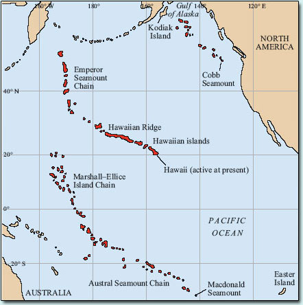
Where everything is moving, it can be difficult to define a reference frame. Most commonly, the hot spot volcanoes are used for this. They are assumed to come from deeper down in the mantle, and therefore should be stationary and not affected by the movement of the plate on top. This is why we have these long trails of ageing volcanic islands. The Hawai’ian trail is best known, with a line of seamounts going northwest. Halfway there is a change of direction. This trail is assumed to be caused by the movement of the Pacific plate carrying away the older islands. The kink was caused by a change of direction of the plate. The same direction and change is also seen in other seamount trails in the region.
If we take the hot spots as stationary, then we can use the hot spot trails to get the absolute velocities, relative to the deep mantle. And now the pattern looks very different. Africa is now slowly drifting to the west rather than faster to the northeast. Parts of South America also have acquired a westward motion. Antarctica remains near stationary though.

So the reference frame can make a large difference in how the plates are perceived to move. The hot spots provide this frame. But there is growing evidence that hot spots are not as stationary as hoped. It seems they can move around by up to 10 degrees in latitude and longitude. There is also the problem of ‘deep versus ‘shallow’ hot spots. Typically, a hot spot associated with an oceanic rift is more likely to be shallow: this includes places such as Iceland and the Azores. They may be moving with the rift, and cannot be considered stationary. So hot spots are divided into groups, and models made how each group may be moving. The plate motions are then registered to a particular frame. A plethora of such models has grown up, each slightly different in the results. Some have argued that there is no solution: the hot spots just cannot be used, because they move around too much.
An example of a paper aiming to determine the motion of the deep hot spots is Wang et al. 2018. They find that hot spots and deep plumes tend to move opposite to the plate, and towards the mid-oceanic ridges. In their model, the Iceland plume turns out to be near-stationary with respect to the European plate. Over 40 million years, it has moved by some 20 kilometers. This explains the stability of Iceland, and it’s lack of a chain of islands. It also means that the whole Eurasian plate is near motionless. In spite of its size, the Eurasian plate contains no hot spots, and therefore no volcanic trails which could be used to confirm (or deny) this hypothesis. The figure below is from their paper. The red arrows show the movement in the ‘no net rotation’ frame (where the arrows add up to zero), and the black arrows show the movement in their reference frame. Note the lack of arrows in Europe, and the fact that the plates now show a tendency to drift westward.

There have been other attempts. It appears that Africa is a fairly stable continent that is not moving much. It has no subduction zones anywhere near, and the Red Sea rift protects it against any pull from the Arabian plate. So models are made that assume that Africa is stationary. Antarctica, another continent which lacks active subduction zones (the one around the Antarctic peninsula seems to have become inactive – frozen, one might say) is also used as a stable reference, but this is not so useful as it can only move north-south, being located around the south pole. It can’t provide a reference for east-west motion. (Imagine being given a treasure map with directions ‘Go the South Pole. The treasure is buried two miles to the east’.)
All these plots are on a square grid. The Earth is in fact round. (If this comes as a surprise to some, do realize that continental drift would be a recipe for disaster on a flat earth, and read the post on pseudoscience.) The curvature of the Earth causes the vectors on the square grid to become curved, while in fact they are straight on a round Earth. For a good overview of movement on the round Earth, this wikipedia link (beware: it is large) shows a brilliant but very large image. The orange dots are the hot spots. The vectors here are with respect to a presumed stationary Africa.
Go west!
There is yet another twist to the story. We have a variety of reference frames tied to the deeper hot spots. These exclude the presumed shallow spots which come from the upper mantle. We can also create a reference frame from those shallow spots. That gives the following pattern (Doglioni et al. 2015):

Now all plates are moving west! Even Europe, which other frames bring to a halt, is now taking part. Australia, previously moving northeast, now has a northwest component. The authors have defined a so-called ‘tectonic equator’ which runs from South America to China and back down through Africa. The ‘tectonic pole’ is in the southern ocean, somewhere between Africa and Australia but shifted towards Antarctica. They show that subduction zones that subduct westward are steeper than those that subduct to the east, which would reflect that the subducted plates shed the plate velocity and start moving with the mantle flow instead.
It is fair to say that this is not universally accepted. There are many different reference frames: the westward drift depends a lot on which frame is selected. The reference frame without rotation of course shows no net drift at all – it does so by definition. Other show less drift than seen in this extreme example. All others show some tendency for the plates to be drifting westward. However, it has been pointed out that this may be caused purely by the movement of the Pacific plate. It is such an important driver of plate tectonics, and the owner of most of the active subduction zones. Are we just seeing the behaviour of one oceanic plate? The ‘tectonic equator’ runs around Australia and Europe: is it just that these are the least active regions of the Earth and happen to be opposite each other? Going back in time, the Hawai’ian chain of islands shows that the Pacific plate changed direction around 45 million years ago. If we use this change, the westward drift may disappear. Did the westward drift only begin at that time, and is this just a random fluctuation of our plate tectonics over time? Many questions. We live in an era which is defined by two things: the decay of the enormous Pacific plate which is fraying at all edges and begins to resemble the decline of the Roman empire, and the high-speed collision of India with Asia, a final event in the closing of the ancient Thetis ocean. Perhaps we should be cautious with drawing far-reaching conclusions from a phase in the Earth’s evolution where so many of the plates are passive, playing the role of a silent and therefore ignored electorate.
And what is so special about the west anyway? Why would the plates follow this direction?
Chasing the setting Sun
The Sun rises in the east. This is known to everyone, although perhaps mostly unobserved by our students. But of course, this is not true. The Sun isn’t doing anything. It is the centre of the Solar System, and far too important to do the Earth’s bidding. Instead, it is the Earth which is doing the work. The Sun is staying where it is, but we are attached to a rotating Earth. The Sun is rising in the east because we are moving in that direction. The Earth is rotating eastward. That is why the US is launching its rockets from Florida and Europe launches them from Guyana in eastern South America. By launching rockets eastward, they get a helping hand from the Earth which is already moving in that direction. (And when the rocket doesn’t make it, it will crash into the ocean which is far safer for people.) (Lurking tells the story of tracking a missile traveling east over the Atlantic, before realizing it was the Space Shuttle which had just launched from Cape Canaveral.)
Our day is 24 hours long. That tells you how fast the Earth is moving. There are tiny fluctuations in this speed. A large earthquake can cause the Earth to slightly speed up as it makes the Earth a little flatter, just like a dancer in a pirouette can regulate her speed (always a she) by pulling in her arms. Global warming is causing a slight decline in the speed of the earth because it removes ice from the poles and causes sea levels to rise – equivalent to the Earth stretching her arms a bit. But those are minute (though measurable) changes.
But there is a more major change.
Some of the oldest rocks on Earth are found in South Africa. The Moodies group is 3.2 billion years old, and is remarkably well preserved. The deposit studied here is found on the Sheba river, near Barberton. It shows layers of sandstone, separated by thin layers of mudstone. This was interpreted as a tidal estuary, where the sandstone came with the flood, but the mudstone was deposited as the tide turned and the water became still. The ebb again would deposit sand, before another mud layer. The thickness of the layers showed the neap-spring-neap tide sequence. From the number of individual layers in a neap-spring-neap sequence, you can get the number of days in a lunar month. The layers were first measured in 2000 (Eriksson & Simpson) but re-analyzed recently by Eulenfeld & Heubeck (2022).

Eriksson and Simpson (2000)
The data gives (via some complex math) the number of days in a lunar month, the number of days in a year, and the length of each day. These were quite different from modern values. Nowadays we have 365 days in a year: at that time there were about 700. Each day lasted 13 hours and each lunar month contained 32 of these short days.
How is this possible? In fact we already knew tide marks in much more recent geology that about 600 million years ago, the day was about 20 hours long. This new result extends this trend much further back. The Earth was rotating faster than it is now. We are slowing down. And the Moon used to be closer to us. It has moved away. That is still going on: from radar reflectors left on the Moon by the Apollo astronauts (science deniers look away now), we have measured that the Moon is moving away from Earth at about 4 meters per century. (Is that perhaps why we need such an expensive rocket to get back to the Moon?). And the days are still getting longer – by 2 milliseconds per century. Every day we have to work a little longer!
The Earth is rotating towards the east. A westward drift of the plates means that the rotation ever so slightly slower than the rest of the Earth. Are they showing the effect of the lengthening of the days? A westward drift of 1 meter per century would correspond to (very roughly) the length of a day that is 3 milliseconds too long – or a few centuries of climate day length change. Are the plates just running ahead in the global slow-down?
Friction of the tides
What is causing the Earth to slow down anyway?
The oceans are far from pacific. They have waves and storms and tsunamis. And twice a day, they have a bulge. We call it high tide, and on the coast it can be meters high. The bulge is caused by the gravitational pull from the Moon (and to a lesser degree the Sun – I am ignoring that here).
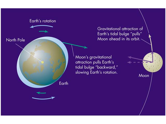
The Moon is orbiting the Earth in just under 30 days. The Earth is rotating 30 times in that period. So the Earth is moving far faster. The tidal bulge must be falling behind the rotation of the Earth in order to stay underneath the Moon. If we know that the Earth is rotating to the east, it follows that from our perspective, the tidal bulge is traveling to the west.
That is what it would like to do. But the ocean is rotating at the same speed as the rest of the Earth – otherwise there would be obvious problems for the 80% of the world’s population living near the coast. So while the bulge wants to follow the Moon, the ocean themselves pulls it east. The result is that the tidal bulge moves ahead of the Moon. And the Moon’s pull is no longer just up, it also pulls back. A new balance is established where the pull back from the Moon is equal to the pull forward by the ocean.
The back-pull is not without consequences. A bulge of water a meter high and 1000 km wide is pulled back. This is the force which is slowing down the rotation of the Earth. One thing that is still needed is a way to transfer the lost rotation to the rest of the Earth. That happens by friction. There is not a lot of friction in water, but there is in the continents. The friction therefore happens near the coast, in shallow water where the bulge is sitting not on oceanic water, but on continental rock. It is the coastal tides where the Earth is slowing down.
There has to be balance. If the Earth slows down, the Moon must be speeding up, by the law of physics which states that action equals reaction. If a satellite goes faster, it will move further away. So the Moon is moving away from the Earth by the power of the tides.
Of course the inertia of the entire Earth is enormous and the effect is tiny. But geological time is very long. Over three billion years, the Moon has moved away twice as far, and the Earth’s day has become almost twice as long. In those days, the 7am alarm clock would have come twice as quickly.
Plate tectonics or Continental drift
How does this work with the westward drift of the plates? It is important to recall that this drift is not universally accepted, and may even be just a random fluctuation. But it does make sense from how the slowing down of the Earth works. The friction with the tides (called, of course, tidal friction) occurs at the surface of the Earth. It slows down the plates. So it would not be unexpected that the plates have slowed down most.
It depends on how the asthenosphere really works. If the viscosity is high, then the slow-down of the plates is efficiently transferred down. If the viscosity is lower, then this transfer is much slower. A low viscosity would predict the westwards drift of the plates. A high viscosity would not.
So is the viscosity of the asthenosphere low enough? The answer is, we don’t really know.
I want to end with one final bit of speculation. Why does Earth have plate tectonics? It is not enough to have plates: the plates have to move in different directions to create the space for mid-oceanic rifts that cycle the mantle material. Subduction by itself is not enough: there has to be room to move. We don’t know when true plate tectonics started on Earth. It may not have been present from the start: some have suggested that it only dates form the past 2 billion years or so. And no other planet in the Solar System has it.
Could the Moon have played a role? If it causes westward drift, that may have helped. And there is another aspect: continents can have deep keels, sticking into the mantle – which hasn’t slowed down as much yet. So the continents get a shove from the mantle, while the oceanic plates go slower. So now plates are moving with different speeds, and that of course will create both traffic jams (called mountains) and space where rifts may form. When the Earth was younger, the mantle was hotter. Even if the asthenosphere is now too sticky for the westward drift to occur, the viscosity may have been lower in the past. The Moon was closer and tides higher. As the first continents formed, they saw extreme tides coming in twice as frequent as we do now. Do we have plate tectonics because of lunar tides on our ancient oceans? It would explain why of all the planets in the Solar System, only Earth has it. Perhaps the Moon brought continental drift to life. It is a thought.
Albert, September 2022

Sources
New Maps of Global Geological Provinces and Tectonic Plates,
Earth-Science Reviews, Volume 231, 104069 (2022)


Alfred up to his usual and well done at that!
This substantiates the “rare earth hypothesis”. It had already been suggested that a large, close-in moon was important for habitability, as it would help stabilize the axial tilt and make the climate less chaotic. If it’s also needed to jump-start plate tectonics, then it’s also needed to maintain a long-term cycle of key nutrients, from carbon to phosphorus. It also adds another factor to the matter of determining when habitability will end, as tectonics can be expected to grind to a halt once the moon has receded sufficiently. (Other factors there include the solar brightening and the solidification of the core, with accompanying loss of magnetic shielding of the atmosphere from cosmic-ray-induced sputtering.)
Meantime, in the map with both red and black arrows, it’s interesting to note that in the black arrows’ reference frame, the African plate has an Euler pole on the coast near Cape Verde, and the Eurasian has one near Scandinavia, both well inside the plates’ boundaries. Eurasia in particular is then rotating extremely slowly about Scandinavia, making western Europe essentially stationary with Russia and China very slowly orbiting it. Africa is pivoting somewhat more rapidly about a point on its northeast coast, which will ram the bulk of it north into southern Europe, squeezing the Mediterranean out of existence and eventually replacing it with a super-Alps. In that event the raising of the Himalayas was the penultimate event in the closing of the Tethys …
(Something is being glitchy with commenting. I got a bogus error message the first time, claiming that VC was “temporarily unavailable” even though I was merrily reading VC about 2 seconds beforehand, putting the lie to any such claim; and the second time it seemed to work, but didn’t actually appear, instead a comment by “ZZDoc” appeared! Here’s hoping the third try is the charm…)
There is also a theory (speculation) that most of Earth’s essential elements for life came from Theia, from the moon forming event.
https://www.sci.news/space/earths-carbon-nitrogen-sulfur-theia-collision-06844.html
Thank you Albert for another gem of learning.
Is it possible that magnetic fields are weakly coupling between the independently rotating core to iron in the crust above the asthenosphere that in turn could help (in part) explain the apparent continental drift?
Interesting hypothesis about the role the moon might play. I wonder if resonating orbits could give a similar result, Io is the way it is because of resonance after all, Ganymede and Europa also get quite some heating too. The Trappist 1 planets might be in a similar position with the inner ones being very active abd further out more mild. Trappist 1e is already the best option to be earth-like, being very similar in size, and with not much water so no extreme greenhouse effect. It would be very interesting if simulations could be run to determine how much tidal heating it gets and if that could get tectonics going.
I wonder if solid earth tidal deformation had not a larger effect.
If the tidal force gets strong enough, solid body tides do become important. It needs a large host (Jupiter will do quite nicely) and a close distance. Mercury has this. Our Moon is too small and too far.
30cm seems like quite a bit, certainly compared to tectonic speed.
but I am struggling to understand the components of the motion. It has been long time since university.
Interestingly when I was a kid in the 50’s early 60’s very many people in the UK believed that the continents had been joined (scientists in particular). I think the USA felt that no mechanism meant it wasn’t so despite really solid evidence to the contrary. So is was the “solid evidence looking for a mechanism” school vs “no mechanism so it didn’t happen” school.
I am always for the evidence proving the rule, even if we have no mechanism.
Cosmology would do well to think the same instead of inventing mechanisms based on what is almost certainly faulty theory. How about explaining the galaxy rotation without hand-fitted dark matter, and the continued expansion by dark energy the same changes to theory? OK, nobody will give you a grant, and if you fail its the scrapheap for you ms postdoc but …, oh, I just answered my own question ….
In passing movement was for years (decades) explained as a push from lifting magma at the MAR etc, which physically made no sense, and the falling cold slabs worked a treat (a recent discovery).
PS Magnetic angle, allowing for crumpling of course, should give you a latitude at least. Longitude probably doesn’t matter as its relative motion that counts.
PPS I have never seen it all put together so succinctly before, and even including the moons possible part is a stroke of genius. This should be in all textbooks verbatim, certainly at “A” level as it says it all. Good job, Albert.
It wasn’t so much UK versus US, and more young versus old. By the early 1960’s, continental drift was main-stream thinking in the US and Europe was not far behind. The conclusive evidence also came around this time but thinking had already shifted. Earlier, Wegener’s theory was accepted by the heavy weights Alex du Toit and Arthur Holmes – not all the elders were equally conservative.
Thank you for the nice words about the post
We didn’t actually try to take a shot. We had a high speed contact tracking at us that gave us concerns given the international circumstances of the time. We didn’t go ant further than putting a director on it for precision tracking. The split video from booster separation made more than a few puckering arses. (Split video means missile launch)
A comment a few minutes after we lost track; “Say… wasn’t the shuttle supposed to launch this evening?”
It is a brilliant story. And of course, rockets and missiles are effectively the same thing.
You come through the Hurricane ok?
Probably the coldest September I’ve ever seen in Florida. Ian put a draw on the colder northern air and dragged it down over NW Florida. No rain, no wind here. In fact, one of the more brilliant days. Bright, sunny.
You need to move south to Palm Beach County. Lovely warm day today. Hearts, minds, and prayers to the West Coast. Have not yet heard from an old friend who moved into a new home in Venice in July. His proximity to the coast and a river give me pause for concern.
S Florida? Nah, I’m good.
Have another friend from Idaho headed to a family event in North Carolina. Waiting to learn the progress of that.
What a fascinating article. Thanks Albert! It was this exact topic that kicked off my interest in geophysics and volcanoes as a young lad at school in the ’60s.
shout:
EXCELLENT !!
/
Thank you.
Also, thank you for that extra info about day length so long ago. Don’t often get both those length details together…
There is a weird problem with the earthquake data for HVO, between the 18th and 24th the quake count everywhere went to nearly 0 at both Kilauea and Mauna Loa, and also at all depths. The deformation data is also out from about the same time except for tiltmeters so there is no GPS data on the recent activity at either volcano.
Those tiltmeters show Mauna Loa is rapidly inflating though, more than the natural variation it had otherwise. The magma body at shallow depth under Mokuaweoweo is not really a chamber apparently but a structure more like a thick dike, probably why most recent eruptions have been fissures along nearly the same line, and why no collapse happened in 1950 or 1984.
Good point about the dike. Could be that ML doesn’t have as much of a magma chamber as has been assumed. When it erupts, there’s no intimation that residue of earlier eruptions is being pushed out, like Fissure 17 to cite an extreme example.
We’ve never been on the scene when ML has ‘gone caldera’, to use a common phrase. One would have thought that 1859 or 1868 would have been sufficiently disruptive, but no.
Yes, we have never witnessed a caldera collapse of Mauna Loa. There was though, quite likely, a caldera forming event sometime between 1840 and 1874 at Mauna Loa, which was not recorded at the time it happened. The reason to think this is that the inner nested crater of Mokuaweoweo (now filled in) was deeper in 1874 than it was in 1840. People seldom climbed to the summit of Mauna Loa back then, and those that did may not have known how it looked before, or may not have been capable of putting together an accurate description of scientific value, so it is not unlikely the changes were missed.
I think that the best date for the collapse of the inner crater would be in 1868. There was an explosive eruption that year from Mauna Loa. It happened a few days after the great Ka’u earthquake, and about a day before lava broke out from the flank near Kahuku. The eruption happened overnight and showered Ka’u in ash. Given that Kilauea has only exploded in 1790, 1924, and 2018, all of which were collapse events, it is reasonable to think the 1868 explosion of Mauna Loa may have been related to a collapse in the summit of the volcano. It also explains why the caldera was in continuous eruption from 1871 to 1877, something that has occurred only once on Mauna Loa in historical time. One would imagine a similar sequence of events to the 2018 follow-up, where lava started to fill the caldera soon after collapse and kept going for years.
Its also pretty visible that a nestled collapse happened at some point, the same sorts of downdropped block crevasses that are seen along the edge of Halemaumau are found in the north part of Mokuaweoweo only are largely buried now.
If you can find a copy of an early edition of Gordon MacDonald’s Volcanoes in the Sea, by all means grab it. The one I have ends with the early stages of Mauna Ulu, but there’s a good amount of ML data and narratives. The central part of Mokuaweoweo was 600 feet lower than the rest of the caldera floor when first surveyed. There were two benches, the North and South Lunate Platforms at either end of the caldera. By the end of the 1940 eruption, they had disappeared and the floor hasn’t changed since then. Maybe the central portion is the 1868 collapse?
“The first accurate survey of Mokuaweoweo was made in 1841, when the maximum depth of the inner pit was 240 m below the summit. Major collapse of the inner pit occurred later; when next surveyed by Lydgate in 1874, it had a maximum depth of 320 m and was being rapidly filled by near-continuous lava lake activity”
From Lockwood and Lipman:
https://www.researchgate.net/publication/262223101_Holocene_eruptive_history_of_Mauna_Loa_Volcano_Hawaii
I did not find any 1974 map, but this is from 1885, still showing the inner pit:
It comes from Characteristics of Volcanoes from James Dwight Dana.
1868 is really the only eruption big enough to have formed a caldera with the right age. The whole south flank of the island moved, the dike to reach the eruption down in Kahuku was at least 50 km and the huge eruption rate suggests it was wide, meters at least, like the dike feeding the Great Crack. The intrusion was probably deeper than 1 km too, so there was probably a similar amount of magma drained as we saw in 2018 just most of it stayed underground by volume. Kilauea did the same exact thing really, only the amount of lava erupted on the rifts was negligible and only one eruption site was ever actually confirmed. 1868 was probably the last event in Hawaii to compare to what happened in 2018.
It seems that most researchers acknowledge that the submarine volume of ML lava flows into the ocean aren’t considered in the ‘official’ measurements, that’s a shame. The point you make about the extreme length and width of the 1868 dike is a good one, but I think we’re still missing the whole picture.
2018 was mostly underwater, 60% of the lava went into the ocean, for a total of 1.5 km3. The eruption in 1960 was similar with the new volume estimate being more than double the original number, over 0.25 km3 vs 0.12 km3. The 1840 eruption is also has a majority of the flow underwater… If I was to guess, probably all of the eruptions where a large a’a flow reaches the ocean are about double the volume on land of that flow. At least flows where it is clear there was a high eruption rate sustained and a channel to the ocean. The flows of 1950 advanced far offshore so presumably those of 1868, which were similar speed, went a long way offshore too. The presence of a littoral cone confirms the lava channel directly entered the ocean, the cone maybe forming on the last day when the flow rate declined and allowed water interaction.
So 1,5 km3 for Kapoho 1961 eruption as well ?
No, somewhere above 0.25 km3. But not that much more likely 0.3 km3 is a high plausible number. Still, this is bigger than Mauna Ulu, and in a month not 5 years.
My hypothesis is that despite the amount of activity seen, kilauea only really created a proper shallow summit magma chamber between 2008 and 2018. 1924 collapse was only a conduit caving in despite being a major rift the length of the whole ERZ on land and probably also a big submarine eruption, a huge drain anyway. 1960 was a lesser degree of the same thing, and both were lower down than Ahu’aila’au too so in theory should have more of an effect. All the collapses in the 19th century were really draining lava lakes, just like what happened to the lava lake last week but way bigger, not an actual collapse of the caldera. The formation of the conduit in 2008 in a passive manner is probably when it began.
Coud be that in 2008 a shallow stoorage vat formed yes at perhaps 1,5 km depth .. But Kilaūea does have a deep high magnesium basalt summit magma chamber a bit south of Halema’uma’u.. that chamber is big and remains unaffected by the 2018 s drainout .. the current eruption is feed from the summit storage complex, thats in turn feed by a deeper pipe
I think the identity of that magma storage is not well kniwn really, but it probably isnt a crystal-free chamber at present, more like a complex of sills and dikes that probably goes into the rift zones too. Magma chambers likely form when parts of these collapse and merge, and probably once that has happened a major eruption occurs soon after. Problem is that there wont necessarily be any change in volume so no warning signal…
DI events may well be this process in action though, given they dont reflect change in volume rather local pressure, and a collapsing intrusion network would have lots of solid material falling which would presumably reduce pressure and which would return after. DIs also became very common after 2008 while were rare before. They have been ongoing after 2018 too so good evidence there is still a magma chamber.
All good edivence for a massive magma body under Halema’uma’u
Interesting article as usual, Albert.
The thought with the moon having started plate tectonics is fascinating.
Then would this mean that i.e. 250.000 years ago whhen the moon was closer and the day shorter plate tectonics would have been faster or slower?
The thesis with the westward drift is not really believable as the deep trenches in the east of Asia pull the Pacific Plate in and the continent out to the East, visible in Japan. Besides east of the East Pacific Rise Nazca, Cocos and other plates should be moving towards their trenches, so east.
If we don’t see any trenches on the European/African west coast and the Americas’ east coast, so passive continental margins, it would mean to me that the time might be wrong, and 50 million years from now (or already ten who knows) one would see them the Atlantic being old enough then.
In any case we see an active continental margin coming up on Asia’s south-coast, and that again is a north movement. And we also see a neo-tranpangaean mountain range building up frpm the Pyrenees in the west to the Himalayas in the east, resulting from a north movement of continental plates and orogenies.
But there is a striking difference between the Atlantic and the Pacific Ocean. The Pacific Ocean esp. The Ring of Fire is bordering continental margins without shelves, whereas the Atlantic Ocean covers continental shelves on all sides.
Models seem to neglect these striking morphological differences.
I tend to agree with Denaliwatch, the trail of volcanic mountains East an West of Tristan da Cuna indicate the eastward and westward movement of the South Atlantic sea floor away from the MAR. As there is no subsidence evident between the MAR and Southern Africa I would assume the continent is also moving North East.This would concord with a suction effect of India’s rapid movement to the north.
You are assuming that the MAR itself is stationary. It isn’t. Mid oceanic ridges also move with respect to the reference frames, just like the plates they break.
MOR’s – like Albert said – do rift jumps, visible in Iceland where the rift moved east not west.
I’d like to further develop my post from yesterday. Basically the (North-) American plate is probably rotating and moving west or slightly north-west visible in the mountain ranges in Siberia that Albert has described in Terra Incognita:
https://www.volcanocafe.org/terra-incognito-the-verkhoyansk-mountains/
Further south the Paciic Plate moving also west borders the American Plate. The trenches are incredibly deep (think of Mariana trench or Kermadec) because the Paciic Ocean is extremly old here:
https://www.volcanocafe.org/hawaii-and-the-story-of-the-pacific-ocean/
Take the map below the Ozymandias poem, M=plus 120 million years.
That’s it. The rest might be either stationary, South America being between two MOR’s, or moving east in the case of South America as the western MOR (East-Pacific Rise) is faster by 10cm/year than the MAR.
The Somali plate is definitely moving east or south-east.
Japan is known to have seperated from Asia and is an Ensialic Island Arc (ensialic derived from si=Silicon and al=Aluminum = continental crust), and Lake Baikal might be a new spreading zone pushing Eastern Asia to the east. This is only in discussion as far as I know. It is also possible of course that Lake Baikal is opening up because of the pulling force of the shrinking Pacific Ocean with its extremely deep and steep subduction east of Japan. So, Japan is no classical island arc. Classical island arcs move in and create active continental margins like in Latin America, Cascades, Alaska and Indonesia. Japan is moving out, so east.
Africa and India, a former part o Africa, not to forget, have a definite north drift, slightly north-east, also visible in Iran.
The orogeny of the Andes is running from north to south, whereas the chain building up between the Pyrenees and the Himalayas has more or less a west-east direction.
If everything (all the plates) moved west all orogenies would run roughly like the mountain chains of Siberia. If they had been moving west all the time in the past Pangaea wouldn’t have happened.
Antarctica seems to be stable having a spreading ridge all around or nearly all around, nearly complete. Nothing can bother Antarctica. If a fix point is needed Antarctica might be the best.
Going south from Japan we have the deepest trenches in the world. From Izu-Bonin down to north of New Zealand we find Ensimatic Island Arcs. The expression is originally from Alfred Wegener and stands for si=Silicon and ma=Magnesium and is also used as a synonyme for oceanic crust.
So, to define plate movements chemistry and morphology are important and speak a distinct language.
Besides, lokking at the differences between the two main Oceans (not looking at the third, the Indian Ocean, right now), they are striking.
Basically, the Atlantic Ocean is an opening in a huge continental mass with the Americas in the West and Eurasia plus Africa in the East. It is the same kind of ocean that Tethys once was tearing a continental mass apart, having started with CAMP. It is just running roughly north-south, whereas Tethys was running east-west possibly like a band between the equator and 30° north and possibly running around the earth before subduction started.
The Pacific Ocean though seems to be an immortal Ocean with dying plates being replaced by new plates and was called Panthálassa in the deep past.
So, basically it looks to me like two worlds (or three), not one. One of these worlds is the realm of Ozymandias, the other one is the continental mass regularly separated by Magmatic Provinces with resulting spreading zones. Three continents then, Antarctica (with New Zealand separated), Pacific Ocean, oceanic crust, and the rest of the world, mostly continental crust. Which means that there cannot be one rule for the whole process.
And btw. Albert I do not think that the Pacific Ocean will disappear (as long as the sun is not too hot). I rather believe that new plates will be created while the Pacific plate is being subducted. No older ocean than this one, it seems immortal. And it might be as important for the world as the Moon is. As far as I know an ocean this size wasn’t seen on Venus. Lucky lady maybe, Earth.
Btw, this (considering it a bit crazy) thesis that e.th. is moving west ignores completely that e.th. started between the South Pole and the equator and is continuously moving towards the North Pole (example Wrangellia and now California). It ignores the poles.
So, after all, the Moon might be important to keep all the water in a continous movement, and the water is important for subduction, but subduction itself might not have anything to do with the Moon, but rather with convection and possibly with the processes in and around the Pacific Ocean.
if the rift jumps ‘east’ then the plate jumps ‘west’ is the same relative motion and might suggest the MOR is (slightly?) more static than the plate margins?
Okay, I am going to step out on a ledge here. As a former person working with military aircraft we had to know where everything was, underneath us. Unfortunately we could never really get a fixed point. The North American plate was moving, all the other plates move too, so we could really NOT fix a determinate location for the geodesics on the globe. Has anyone figured out a solution for this?
For example, when Iraq was bombed by cruise missiles all the missiles hit about 8 ft off target. This was due to plate movement. It was obvious after looking at the post explosion photographs. But no one seemed to know how to make an accurate map of where things really where, according to an ECEF or Lat/Long/Alt geodesic before launch (this was embarrassing to certain people)
Any ideas on how we can define an accurate north pole and south pole and especially points in between?
The poles are relatively stable, the magnetic poles (except mid reversal) are relatively stable.
That deals with latitude. Declination of magnetised rocks will work, some thought is needed as flat level rock rarely stays flat and level over geologic times. Adjustments can be made as strata are generally laid down horizontally so latitude is the angle between the strata and the magnetic direction. Note that rotation affects where north is, but not the declination so is latitude invariant. Note ‘level’ means you need a 2-D sheet for your strata direction.
Longitude is, as you say, relative and arguing about what moves and what is still is simply irrelevant and shows a deep misunderstanding of geometry.
As you say.
8 feet off target is a technical mistake. The fastest moving plates are Nazca and Cocos as the spreading is fastest – in some places up to 15 cm were measured – at the East-Pacific Rise. The spreading in the Atlantic Ocean is slower, between 2 in the north to 4 cm in the south per year. This doesn’t explain eight feet off-target. The movement of the plates is much much slower than rockets fly.
So I believe that off-targets can possibly be explained either by mis-calculation or by high winds. Nothing that we do has anything to do with moving plates, otherwise all cities in Japan or in Latin America would have collapsed by now.
Geology is very slow, and what we are seeing is a window. If mankind still exists (sceptical) in 50 million years they will see another window.
Also: 8 feet off on Earth is “a mere” 17 feet off in Space, different dimensions:
“erupted with joy as Dimorphos filled the field of view on Dart’s camera just before then going blank. Initial calculations suggest the impact was a mere 17m off the exact centre of Dimorphos.”
https://www.bbc.com/news/science-environment-63039191
Somewhere (maybe here in Volcano Cafè?) I have read that all the references in GPS relative to Australia had to be recalibrate some years ago simply because the continent is the fastest moving, and was about 3 meters north where it was aspected to be.
Someone other have this information ?
We would normally use a space-based reference frame. In the past that was done using radio telescopes, which can measure very accurate positions for radio sources, and exactly when they pass the meridian. That gives positions to centimeter accuracy. That is also how we know about leap seconds, the slight fluctuations and changes in the rotation rate of the earth. Nowadays GPS is better: it can be as accurate and covers a lot more of the surface, not just where there happens to be a radio telescope. Do note that either only works on solid ground, not out at sea.
The problem this post is about is how those plate movement compare to the movement of the deeper earth. Does the crust overall rotation at the same rate as the inside? Or is it a tiny bit slower? The latter would cause a net westwards drift.
For Chad:
(just news I saw, you might be aware of it)
“Jupiter will be brighter and bigger in night skies as it swings by our planet at the closest distance it has been in 59 years.
Australians will be able to see the largest planet up close in the coming weeks, with Tuesday being one of the best days to view the vast gas planet provided skies are clear.
Midnight will be the best time to see it sitting above the continent but dusk and dawn will also offer better-than-usual views.”
https://www.dailymail.co.uk/news/article-11253165/Jupiter-closest-59-years-Australia-nights.html
With binoculars you should be able to see the moons of Jupiter. Last night two were visible.
Albert
btw, excuse me for objecting. As I survived 😉 objecting to Carl many times I thought I might survive this as well, esp. as I consider myself sort of a tiny bit trained by you yourself, see links to older pieces. The Wrangellia Trilogy belongs here as well.
https://www.volcanocafe.org/wrangellia-how-the-west-was-won/
As it is raining (no Jupiter moons ;-( I have kept busy with one of my hobbies which is wandering maps. So I followed the impressive 1.450 miles long Colorado River from Baja California up to its spring in the Colorado Rockies, realizing that it originates from a position roughly 500 miles south of Yellowstone and then followed the Snake River coming from Yellowstone.
Those two rivers, only 500 miles apart, are separated by a water shed as the Snake River drains into the Columbia River and then in the northern Pacific Ocean whereas the Colorado River drains south in the Golf of California.
While doing this I saw this nice picture of the Snake River in the Tetons, hope it is okay concerning size and pixels:
From https://en.wikipedia.org/wiki/Snake_River
I only got there by thinking about extension and mantle plumes. Was a nice home office walk. The US is so incredibly huge that one cannot visit all of it. Can thoroughly recommend such walks. The Colorado River is one of the rare rivers that become wide and then small again and then really wide and then tiny and wide again, a miracle river.
Next for me is extension helped by mantle plumes (CAMP, possibly).
Albert
Getting back to that net movement, and please keep in mind that this way of thinking reaults from your own brillant posts about Plate Tectonics that I upholstered with results, papers i.e. or books from known geologists:
It doesn’t work as e.th. is being pulled in different directions with the exception of south. It was this way with Pangaea. The parts spread into different directions.
Based on the assumption that subduction and convection is the driving force (like you wrote numereos times) there must have been subduction east of the peninsula and the island of China (island arc back then?) and on the other side, the west coast of Pangaea.
This pulling force needs a weak spot, possibly extension, possibly caused or helped by a deep mantle plume (CAMP) which must be gone by now considering their assumed age. And then Africa and Europe travelled east.
The same thing with India: The driving force might have been the beginning subduction of a very old ocean, Tethys. between India resp. Madagascar and Africa there must have been a weak spot helped by one or even two mantle plumes, and then India didn’t “travel” north like we all say, but was pulled out to the north.
In the far future – this was aldready dicussed here, the same thing might happen to a) America’s west (Yellowstone), b) Asia’s east (Baikal region),c) Africa’s east and d) possibly Europe’s west (Rhine Graben). This is how I got to Yellowstone, of course.
Thing is, to figure out a net movement to the west seems impossible with plates wandering in all directions with the exception of south. But a stationary Antarctica seperated by spreading ridges is possible.
So, in the far future, in case things were understood so far (concerning deep history) there might be a LIP in the American West and others in Asia’s east and the African Rift, what Jesper is assuming as well.Not all at the same time as usual.
You might like this paper about vertical subduction initiation versus horizontal subduction initiation:
Headline:
Rapid subduction initiation and magmatism in the Western Pacific driven by internal vertical forces
https://www.nature.com/articles/s41467-020-15737-4
Accidentally found by looking for the name of the Chatham Rise.
Fascinating article, Albert, Thank You.
The article you wrote about the boulders that moved across the Death Valley dry lake beds got me to thinking about the force of moving air. While the force of air on plate movement may not seem to be very much, when integrated over a large area and over a long time it might have a surprising result. I live on the west coast of the US. The prevailing surface wind is from the northwest, the same direction as the relative plate movement of the Pacific and NA plates here. It’s as though our mountains are like huge sails. Crazy idea?
Mauna Loa looking pretty serious now, the tilt is a small scale but showing a marked excursion since it had that swarm the other day. Its not right about to erupt but I think the chances are high for it doing so in the coming months. There have been other swarms like this but I cant recall any of them having a significant or long lived impact on the tiltmeter, this is the first swarm to show magma influx to the shallow system that tiltmeters are sensitive to. Im expecting it to be upgraded to orange soon.
HVO also seems to have a total failure of its GPS data, they all have a gap, this could be pretty serious. The tilt is showing inflation at both Kilauea and Mauna Loa though so I think we will see a big jump up on both of their GPS plots.
Exciting! Thats one of my favorite volcanoes .. I like my volcanoes as large and as bloated as its possible to be 🙂
And it cant be better than Hawaii .. at current
I do love Mauna Loas massive scale and shape .. and that looong and wide snow-cap as maginificent as it can be
I just wish it was even larger : D
Been at Mauna Loa many
Times its magnificent really
Thank you, Albert, for clarifying me on one point I misunderstood for decades.
Being not a geologist, when I studied plate tectonics at the lyceum level (many years ago, sadly) I was persuaded that the engine driving plate movements was friction deriving by mantle convective movements on the lower face of plates, not the weight of their subducting parts, more dense than the mantle in which they are penetrating.
But now I have to find an explanation to the rising up of the crust, melted by the heat and higher temperature found in the interior of the mantle, that in my memory (bad ?) was the origin of volcano arcs standing on the margins of the overriding plate on the opposite side to oceanic trenches.
Anyway, thank you and Volcano Cafè ! Therein ever something to learn, o to be learnt again !
Once an oceanic plate breaks, the mantle below will automatically rise. This mantle is much warmer than the ocean crust and therefore a bit lower density. Therefore it floats higher. This is sufficient to build 4 kilometer high rises, to about 2km below sea level. To go higher than that (Iceland) requires more heat, but normal mantle heat suffices for the typical mid-oceanic ridges. The material flows sideways with the rest of the oceanic crust, and at the same time cools, initially quite fast. As it does so it gets denser again and therefore sits deeper. This is what causes the width of the mid-oceanic ridges.
The volcano arcs result from subduction dragging seawater down into the mantle. Water lowers the melting point of mantle rocks, so magma forms above the subducting slabs and, being buoyant, rises to the surface where it forms volcanoes. These tend to be located above the point where the descending plate reaches a depth of 100 km. How far inward from the edge of the overriding plate that is depends on how steep the subduction is.
This is fascinating!
One argument against the moon’s influence is the lack of a moon of Venus, despite some evidence of plate tectonics. Although of course there could have been one at one point.
Phobos and Deimos of Mars are also likely too small to exert much influence, short-lived and will break apart soon (astronomically speaking!).
If Venus was also hit by a moon – and there are even models proposing it happened twice:
https://skyandtelescope.org/astronomy-news/why-doesnt-venus-have-a-moon/
then Plate Tectonics on Venus might also have stopped (in case there ever were Plate Tect. and water) because Venus suddenly rotated the other way around and much too slowly.
Imagine that. It would make me sad.
The impact thesis which is one explanation for Earth’s Moon shows again that the lady (Gaea) is more than lucky.
The only explanation, last time I checked. If it had co-accreted with the Earth, it would have a similarly proportioned iron core, which it doesn’t; and it has the wrong composition to have formed elsewhere and later been captured by Earth’s gravity. It’s basically the same composition through-and-through as Earth’s mantle, and the simplest explanation for that is that it is a chunk of Earth’s mantle that somehow got ejected into space.
Read about the Grand Tack Hypothesis. It is only a thesis, but fascinating. I sort of love Venus, but that might be because it is similar to Earth and also mysterious.
David Grinspoon who has written a lot about Venus definitely loves Venus and is looking forward to having new material.
I can invent a small story about Venus and Earth. Venus and Erth both loved Jupiter and got into a jealous fight. Finally Jupiter had to throw one out and that was Venus. This is referring to the Grand Tack Hypothesis.
What I like most about physicists doing the most difficult and precious work is that they also have feelings about all that stuff in the air (cosmos) and also Earth.
Basaltic magma chambers may grow catastrophically fast
https://phys.org/news/2022-09-basaltic-magma-chambers-catastrophically-fast.html
Thanks for the link. They have two other great articles from the same authors concerning Bushveld:
https://phys.org/news/2022-09-discovery-re-interpretation-magma-chambers.html
https://phys.org/news/2022-03-bushveld-complex-functioned-big-magma.html
“Latypov asserts that the size of the resident melt column in the Bushveld chamber at one stage was “really staggering—over 5 km in thickness and over 380,000 km3 in volume. This amount of magma is several orders of magnitude larger than any known super-eruptions in the Earth’s history.” It is only comparable to the extrusive volume of some of the Earth’s large igneous provinces such as the Karoo flood basalts in South Africa.”
It also seems to me that layered intrusions were massive tanks of crystal poor (nearly crystal free) basaltic magmas. But I think that silicic magma chambers are too relatively crystal poor, less than 20 % phenocrysts, judging from the fact that caldera volcanoes like Taupo, Yellowstone, or Okataina never, or almost never, seem to go over 20 % crystallinity in their erupted lavas. I could be wrong, but if this is right then it means such magma chambers are also intruded much faster than it is presently assumed, or that some mechanism keeps them in a molten state, like maybe continuous convection of hot basalt into their base.
I’d be careful with this as other scientists seem to believe that such chambers might have been either transient or completely absent:
“These studies have concluded that molten magma chambers are either transient or non-existent in the geological history of the Earth.
“Although, modern geophysical surveys are indeed unable to conclusively identify any present-day magma chambers with a large volume of eruptible melt, it is too early to discard the existence of such chambers in Earth’s crust………” from your first link, Héctor.
Gathering: No proof so far.
What is particularly disturbing is the fact that they link them to LIP in Bill’s article about Greenland. LIP though might have been created by mantle plumes under thinned crust. And that exists (probably Yellowstone).
Maybe there are no large crystal poor chambers at present on our planet, or they are few and remote for us to have detected. What I distrust is the idea of mush reservoirs underlying calderas.
Or maybe crystal poor chambers are unstable and geologically short lived, with their very existence being a likely precursor to an imminent major eruption. Like I said below regarding Kilauea in 2018 (although Kilauea is usually crystal poor anyway). Laki was maybe the result of such a chamber forming, as Grimsvotn itself is not really big enough to have created it directly.
I imagine the Galapagos volcanoes could also have large chambers like this, especially Sierra Negra, which has a shallow caldera and massive eruptions compared to the others, which have mostly got deep calderas with several tiers of collapse.
I see two ways of getting large crystal-poor magma reservoirs. 1. Fairly short-lived at high temperatures so that crystals don’t form (note that such a large chamber would cool extremely slowly); 2. very long lived at a constant temperature (this allows all crystals to settle out).
Option 1 could be combined with having the magma collect deeper (below the crust) before ascending much later
Maybe this is what happened at Kilauea before 2018. Not quite on the scale of the paper but same process.
1960 eruption was very big and of similar intensity, and was even at a lower elevation, but caused no caldera collapse only some minor subsidence within Halemaumau. The massive rifting and intrusions of 1924 in the same area also did nothing more than collapse the conduit, no actual caldera. Perhaps the next 60 years of rift activity also saw the magma system under Halemaumau grow from being only a conduit to a real magma chamber. Maybe not even close to 60 years, it might have taken only a few years from when the overlook lake became permanent at a high level (2012 onwards). That is also about the time Pu’u O’o started to decline and some magma was able to get further east.
It has not been checked yet. Might have knocked some things offline. The only instrument you can see any sign of it is DAND, that I could find. Does show on USGS latest earthquake map.
2022-09-27 22:43:58
Earthquake
Magnitude:4.4M
Depth:20.8mi
looks pretty on Seismometer Monitoring Station PPLD.
some following shakes too
Article about one of those typical scientific arguments called “row” with one decisive sentence:
“Colleague Odette Toloza, currently working in Germany, described Mr Marsh as ‘the best in his field’ in an interview after he vanished.”
https://www.dailymail.co.uk/news/article-11255027/Missing-British-professor-61-argued-PHD-student-vanishing-Chile.html
This seems to be a full translation of a chilean news article yesterday. Yes, Tom is top in his field, and no, an argument with a student seems unlikely to be relevant
I wonder what’s going on in the middle of the north mid-atlantic rift, around lat 54 N, lon 35.2 W. It’s an earthquake swarm like nothing I’ve ever seen along the MAR, and there seem to be no notable volcanic features in that area.
Yeah it’s between the Charlie-Gibbs Fracture Zone and the Bight Fracture Zone.Some strong tectonic forces at play there.
There’s also a sizable swarm occuring north of Kars in Turkey. Though it dosen’t have as many high magnitude earthquakes like what’s happening in the Atlantic.
One of these fracture zones corresponds to the Great Glen Fault in Scotland, loosely
I wonder why the USGS calls it the Reykjanes Ridge while it’s ~1000 mi. away!
It’s correct as the Reykjanes Ridge that’s to say the name goes all the way down to the Charlie-Gibbs- Fracture-Zone which can be seismically active.
Btw, in “Red Octobre” submarines were supposed to be cruising there (in reality it was filmed in a tank).
The day before yesterday there wer “quakes” in the Baltic Sea.
removed – admin
removed – admin
removed – admin
removed – admin
Political arguments are best kept for other blogs. We welcome people of all political persuasions.
It might have to do with this area, transform fault, crossing and displacing MAR, two known seamounts
https://en.wikipedia.org/wiki/Charlie-Gibbs_Fracture_Zone
Ignored that Chacanger mentioned it, sorry.
DART’s impact as seen from Earth.
ugh
once more

Scott Manley on DART
Asteroid Smashing Looks Like Nothing You Ever Imagined
Meanwhile Hurricane Ian continues on through Florida
https://twitter.com/BrooksWeather/status/1575282538590965763 Brooks Garner FOX 35
@BrooksWeather
Fort Myers and Naples have been inundated by storm surge. Higher winds beginning to make their way inland across the rest of Florida, but it has weakened to a high end Category 1 in the last hour with 90 mph (40 m/s) sustained winds.
Orlando over to Canaveral/Melbourne now seeing conditions rapidly go downhill overnight. Ian will head back out to sea and make a secondary landfall somewhere in South Carolina as either a strong tropical storm or minimal hurricane.
Over 2 million without utilities at the moment
https://poweroutage.us/area/state/florida
Almost directly over Cape Canaveral now as a Tropical Storm.
2017 was a coin-toss to the last. Irma was approaching the east coast of Florida looking to come on shore in the Miami area. Most prepared for that. Then it shifted west and tracked a line north up the middle of western side of the state, following residents who fled north to escape it. We are in southern Palm Beach County, 13 miles inland from the coast, in a green zone and had everything that mattered stowed in the house. We were clobbered by the rain bands. That Sunday afternoon, a wind gust, possibly tornadic, felled a tree which took out a feeder cable and we were without power for 5 days. Sent the household to stay with family in NJ on the following Tuesday. IMHO, the best evacuation plans for dealing with hurricanes which track like those of the past 5 years is to head for the Midwest. Kansas or Oklahoma. Nothing on the eastern seaboar, east of the Mississippi River is assured . People who invest heavily in ocean front real estate or fail to consider the inundation zones when considering property here are playing hurricane roulette.
https://twitter.com/Sean_Breslin/status/1575526950978088960
Back up to Cat 1
Oh and some good news
Ingenuity seems to be transitioning back to more regular operations. Still not out of winter yet but power availability is improving again and we’ve had three flights so far in September. First time Perseverance has seen Ingenuity in a while. 🙂
https://fosstodon.org/web/@65dBnoise/109075328047613050
Nice pic, thanks. Isn’t it a bit better in Florida than expected?
Kilauea and Mauna Loa GPS, finally updated.
Actually looks like Kilauea is the one that is nearing breaking point sooner. The intrusion last week (that HVO now supports) seems to have been a response to the dead signal that has been showing for some weeks now, rather than a lake drainout. Mauna Loa actually hasnt changed all that much really.
Hehehehehahahhä
Going To get my curtains of fire
https://archive.org/details/CHMHUB461950MaunaLoaEruption
Original footage from 1950.
Keep in mind the eruption had already subsided a lot by the first morning… Technically the eruption lasted 3 weeks but nearly the whole thing was within the first 3 days, after which it was basically some small shields at the lowest elevation vents. Far as I can find there has not been a more intense effusive eruption than this in at least the time we have been trying to record this stuff. Even Laki was not this extreme.
In light of what the Hawaiian volcanoes might do regarding magma chambers, I think 1950 was basically a failed caldera collapse, it happened before a chamber was fully formed. It might well compare to the 1960 and 1924 collapses at Kilauea, large magma withdrawl but no actual caldera. The way the entire length of the dike erupted full force at the same time though, that is pretty unique at least in recent eruptions. 1984 was similar in some ways though, so that could mean the next eruption behaves similar…
As far as I can tell, most of the SWRZ eruptions have been of this ‘hemorrhage’ type, (1868, 1950) while the NERZ have been more of a ‘steady-state’ –1935. 1942. 1984. (1880-81 was *really* steady!)
The opening phase of NERZ eruptions has also been very intense, I think, descriptions of one historical NERZ eruption are spectacular, with huge fountains and a tall plume that drifted pele’s hair over Hilo, I think it was 1855. Later some of them transitioned to an steady-state effusion. It has probably to do with lower tensile stress in the NERZ during historical times in contrast to the SWRZ..
In the past such eruptions also happened in the SWRZ. For example a SWRZ eruption around 800 years ago the Keapohina eruption produced long-lived pahoehoe flow fields that reached all the way to the south coast of the island. Other similar long lived SWRZ eruptions happened around that time, like the Kalahiki eruption which is in a roughly equivalent state of weathering as Keapohina. Eventually this culminated in the massive SWRZ Hapaimamu-Kipuka Kanohina eruption, which I now think was around 1400 AD, rather than the younger date indicated by radiocarbon dating, because the Hapaimamu eruption flows are far more weathered that the late 18th century Manuka flows, like a few centuries before, more weathered. Since the high period of activity marked by the Keapohina, Kalahiki, Hapaimamu, and other contemporaneous eruptions, there has been very low activity in the SZWR until 1868, with only the small and intense Manuka, and Pele Iki eruptions. During this time the SWRZ would have been building up tensile stress through slow spreading. That is why in 1868 everything gave away catastrophically, while the rift had built tensile stress, the distal flank had built compressive stress and was ready to fail. The 1868 dike went further down the SWRZ than any other intrusion of the past 2000 years, and set off the massive 7.9 earthquake. Throughout the rest of the historical period the SWRZ has been in a high tension stress albeit slowly returning to a more compressed state.
A map that places many of the flows I’m talking about:
https://ngmdb.usgs.gov/Prodesc/proddesc_9152.htm
That map is old, HVO have said the one released in 2020 is more accurately dated and not just through radiocarbon but also chemical analysis and in some cases contemporary reports. The Hapaimanu flows were originally dated to the time you say but surface appearence is not always reliable.
Manuka flow also erupted without fountaining, and flowed over a bed of tephra from Hapaimanu, which seems to have had strong fountaining. Further downslope Hapaimanu is bare rock and looks unweathered.
Eccentric eruptions also seem to be a bit more steady, 1859 began as a lava flood before staying open and forming pahoehoe flows. Perhaps the long lived eruptions are related to more efficient connection to the deeper system where the fast eruptions that stop quickly are rapid drains of the upper magma system without a high supply rate at the time. Mauna Loa had a very high supply rate from 1850 to 1868, there were some huge eruptions in this time and 1859 had very hot lava (1200+ C). Kilauea was pretty passive at this time, so this 20 year period could have been a true switch of the magma supply. After 1868 it declined to a more modest value, and Kilauea got more active, so seems likely they were both fairly equal in supply following the 1868 eruptions. Mauna Loa though has no extensive rift storage to fill so was still able to erupt often from flank vents while Kilauea was more intrusive and summit filling. Both of them also had lava lakes in the 1870s which is interesting. 1877 Mauna Loa drained out its lake offshore, then erupted one last long lived flow in 1880, but ever since then eruptions have been only fissure eruptions of high intensity and short duration.
Longer eruptions did begin to resume in the 1930s as Kilauea was basically inactive following 1924, so in this time Mauna Loa probably captured majority supply again. 1935 transitioning partly to tube fed flows. 1940s summit eruptions were also long but WW2 made it hard to observe. 1949-1950 interval seems to have had brief very high supply which is probably why that years eruption was so big, but the supply dropped to basically nothing afterwards for over 20 years, seems like the whole deep magma system tried to surface and needed a recharge from the bottom up. Ever since then Kilauea has been dominant, and continues to be. Since 1974 though Mauna Loa has had low level continuous supply, between 5 and 30 million m3/year, generally somewhere about 10 million. 1984 was probably 0.4 km3 of magma drained total, but at average of 10 million m3 a year for 48 years that is about 0.5 km3, so at least there is a break even with the last eruption. Not much left to do anything big yet though, so if an eruption happens this coming year it wont be another 1950. Kilauea is still the better bet for a big eruption in the forseeable future.
If you follow the Hapaimamu fissure system, uprift from the main cone, you find a series of lava flows and channels which issued from a long curtain of fire. Lavas from this early curtain stage meet directly with the Manuka lavas, and they clearly do not have any of that reddish pumice blanket, being upwind from the high fountains that issued from the main cone. The lavas are unmistakably in a different state of weathering, with Hapaimamu lavas being ~centuries older than ~1750-1820 Manuka. The Hapaimamu lavas get much younger looking downslope but that seems to be due to a drier climate next to the southwest point of the island, other flows in that particular area are well preserved too.
It is clear that Hapaimamu is centuries older than Manuka. I would tentatively place around ~1300-1400 AD. Because if so it would explain a couple of things. Why the Southwest Rift activity of Mauna Loa came to an end around that time. Hapaimamu not only collapsed the summit caldera, Mokuaweoweo, but it also collapsed small chambers in the Upper SWRZ, making a short chain of craters, and this likely impacted the ability of Mauna Loa to make dikes that go into the SWRZ. The 1950 dike, for example, likely initiated from the Upper SWRZ, not the summit, given the location of its uppermost fissures. This would also have led to the SWRZ style of activity prevailing in the18th century and historical times, and to the Great Kau earthquake, with mostly very long dike intrusions that reach down to very low elevations and make short-lived eruptions, due to tensile stress built up from slow flank creep during centuries of low activity. As opposed to more long lived eruptions focused in the upper and middle portions of the SWRZ during earlier times, complex long lasting eruptions like Keapohina, Kalahiki, Pohaku Hanalei, or Kipahoehoe.
It also explains the Observatory and Aila’au flows of Kilauea, the caldera of Kilauea had already started to weakly overflow around 1100 AD, the Old Kalue flows, however there was a break of activity until sometime later, until the paleomagnetism had changed. Around 1400 or so I think the Observatory overflows started. And the Aila’au flows themselves were erupted during a probably short-lived peak in paleomagnetic inclination during the late 15th century, a peak in which Mauna Loa seems to have been largely dormant given none of its sampled flows have a late 15th century or early 16th century-like paleomagnetism. Aila’au was followed by East Rift eruptions like Puu Kaliu, and Kahawali. Why the caldera of Kilauea started overflowing so vigorously is unclear. It would make a lot of sense however it may have been triggered due to a collapse, and heavy disruption, of Mauna Loa’s plumbing system. With the supply being channelized towards an overflowing lava lake at Kilauea.
It would really be possible to reconstruct the history of Mauna Loa and Kilauea to great detail. One would one need to combine radiocarbon, paleomagnetic, stratigraphy, and isotopic data. Radiocarbon gives an absolute date, which is great, but it is not always available, plus it can be wrong by centuries. Palomagnetism is more precise, but it only gives a relative age, you know two flows formed in the same century because they share the same palomagnetism. Isotopic data is even more precise, because volcanoes can change their isotopic composition in a timescale of decades, or even years, then it would have a high temporal resolution if the volcanoes isotopic variations can be uncovered. And stratigraphy of course helps know what came before or after with absolute certainty, so you can know the order of isotopic and paleomagnetic changes. USGS though did paleomagnetic dating mostly in 1980s, and has abandoned that method in Hawaii, with a few Kilauea exceptions, and most of Mauna Loa’s SWRZ is lacking paleomagnetic dating. They haven’t done any thorough isotopic measurements of prehistoric lava flows in Hawaii, so that is still lacking as well.
A new option for the order of events has just occurred to me. One I think better fits radiocarbon data of Mauna Loa, and isotopic data of post-Kulanaokuaiki tephra caldera filling at Kilauea.
A series of long lived pahoehoe flows went down to the south coast of the island around the same time, which issued from the Keapohina vent complex, or other nearby fissures, these are Kipukanene, Alapai, and Waikapuna. Kipukanene has 5 radiocarbon dates which average around 1180 AD. Waikapuna has 2 averaging around 1190 AD. Alapai one date of 1180. So that places the last dated large long-lived SWRZ eruption around 1200 AD. If I’m correct and the reason the eruption style of Mauna Loa changed was Hapaimamu. Then Hapaimamu may have taken place around 1200 AD. Give it a few decades of fast Mokuaweweo caldera filling, and then Kane Nui o Hamo happened at Kilauea. Kane Nui o Hamo, the large prehistoric shield volcano of Kilauea’s East Rift, carries the same paleomagnetism of the Kipukanene flow. I before thought it had taken place some time before the Kipukanene flow, but now I think it may have been some time afterwards, say 1300 AD. Perhaps immediately after Kane Nui O Hamo, the summit of Kilauea would have collapsed in the Upper Kulanaokuaiki eruption, which is recorded in the tale of Pele and Kamapua. Then the caldera would have rapidly filled and overflowed producing the Old Kalue flows which still carry the paleomagnetism of Kipukanene and Kane Nui O Hamo. Paleomagneitsm then shifted towards lower inclinations followed by a return to higher inclinations and the eventual peak during the time of the Aila’au flows and Puu Kaliu. Isotopic data of Kilauea from the time of Old Kalue show low Pb206/Pb204, that is indicative of Kilauea having been in a state of high activity for several decades before, since it takes decades to revert the high Pb206/Pb204 that it develops during periods of low activity, the earlier high activity presamably being Kane Nui O Hamo and other eruptions of that time. And that state of high activity must have continued into the Observatory and Aila’au overflows, which the Observatory flows still carry the low Pb206/Pb204. Eventually the next major collapse of Kilauea came in 1500 AD, possibly related to the Puu Kaliu eruption.
I think this sequence of events may actually be more likely considering all the known data. Or at least more close to what really happened.
As for the one radiocarbon date placing Hapaimamu around 1710. I wonder if it could wrongly be dating Manuka lava, or maybe a fire, or just contaminated for some reason. The weathering clearly shows it must be centuries older than 1800.
Interesting interpretations, I guess without consistent data of all methods to compare to it isnt really possible to know what happened. Hapaimanu was definitely an eruption that would spell disaster today, several km3 of lava erupted in probably a short time of maybe a few months. Was an eruption of the same calibre as the biggest in Iceland.
Also an interesting take for the rapid filling of Kilauea, first doing a massive shield which by analogy to Pu’u O’o probably was a many decades long eruption, followed by presumably just as fast filling to overflow. Powers Caldera was a lot wider than the current caldera, the deep pit was probably as wide as the outermost faults seen now or close, so a massive volume of lava to fill. I have not looked at any paleomagnietic data but I assume changes in that take somewhere on the order of years to decades between orientations, so Kilauea could have filled in the whole caldera in a short time of less than a few decades. Actually makes the idea of an overflow in the next years not unlikely, at current rates there will be no caldera left by 2030.
Under the Observatory flows are a lot of a’a flows, some are pretty huge actually, much bigger than anything derived from recent eruptions in the area. Per your hypothesis of a rapid filling of the Kulanaokuaiki/Powers caldera it would have had a gigantic lava lake inside it, I wonder if these SWRZ flows are from frequent fast drainouts of the lake, and a good analogy for what we might see in the near future… Can imagine some point in the not distant future seeing a flood of lava race down the steep slopes adjacent to the SWRZ.
Paleomagnetism is somewhat variable. You can get sudden changes, for example, briefly before the Keapohina eruption, the paleo-inclination jumped suddenly from 24 to 40, which is a very obvious change. But then you may get prolonged periods of up to a few centuries where changes are subtle. Normally you may be able to narrow down the age of a lava flow to a particular century, not more. But with more data, and data that is carefully measured in un-deformed lava, the precision could perhaps improve.
I think it is not too easy to get Mauna Loa or Kilauea to go into a period overflowing. You need two things I’d say, one is a caldera forming event from the volcano that damages its rift conduit, and the other is for the neighbouring volcano to still be disrupted by its own caldera collapse. This worked for Kilauea after the Upper Kulanaokuaiki eruption, this collapse event was the one that made Napau and Makaopuhi craters in the ERZ, so it was a pretty big hit to the plumbing system of the rift zone, plus Mauna Loa was still recovering from the Hapaimamu collapse event, and was thus not capable of taking over the supply. So Kilauea caldera filled and overflowed quite spectacularly. But this did not happen again after the ~1500-1600 (Kahawali), and 1790 collapse events, because Mauna took over the supply following these collapses. If Mauna Loa had not started producing rift eruptions from 1843 onwards then the caldera of Kilauea would have kept filling rapidly and overflowed. But the caldera filling halted in the late 1840s as Mauna Loa started to produce frequent rift eruptions.
I do not expect Kilauea will overflow the caldera for mainly one reason, the 2018 collapse did not do any damage to the East Rift Conduit, there was no collapse of the Chain of Craters. Kilauea has already shown it can use perfectly, feeding the MERZ in the post-2018 period. So that most likely as the caldera floor reaches ~1000 meters in elevation, the East Rift will start rifting again. And even if 2018 had damaged the rift plumbing I expect Mauna Loa would take over before any significant overflow of Kilauea’s caldera can happen, like it was with the 1840s.
I read this sequence of comments like five times over.
Bravo gentlemen.
Yes 1950 was insane… 5 fagradals volumes just overnight
How on earth did you find that footage? Well played.
I actually just found it by searching for the eruption in Google videos, first page 🙂
The first time I saw it was about 2 years ago but I lost it, rediscovered it recently. The first time I saw it made me really consider if we judge eruptions the wrong way, I think intensity is a much more important factor than volume unless the eruption is very large scale. And as far as effusive eruptions go this is number 1. 0.4 km3 of lava and 90% of that erupted in 2 days, the eruption rate was as high as 20,000 m3/s. The volume underwater is unknown but considerable, the flows are known to have advanced over 10 km offshore which is almost to the abyssal plain. It would not surprise me if the volume is 50% larger accounting for that. 30,000 m3/s…
The swarm on the Reykjanes Ridge is continuing with several M5. An eruption here seems possible.
Nearly straight to the south, in a parallel fracture zone to Charlie-Gibbs FZ, the South Sandwich FZ, nearly same depth, 6.5 15 hours ago.
Any connection possible or pure incidence?
The swarm at Mauna Loa is still going on. No sign of tremor. GPS suggests that the inflation is underneath the centre of the caldera, not under the southwestern rift as previously
Honestly, not really that surprising. Usually, in historical times, Mauna Loa usually erupts at the summit first before going to the rift zones. With this, the eruption could happen closer to the near future than we think (though not like tomorrow or next month, but maybe a year or two).
On that note, I saw this article on the risk of a large earthquake on the volcano due to the magma changes within the volcano:
https://www.sciencealert.com/scientists-reveal-the-full-danger-of-the-world-s-largest-active-volcano/amp
I think there’s a 6km volcano on the Charlie-Gibbs/MAR interface – Hecate seamount I believe it’s called.
Charlie, a weather station and US naval ship Joshua Willard Gibbs gave the name (I thought it was the last pirate executed on Ellis Island, better looked it up though), here nice description with bathymetric data:
“And it’s massive! The Charlie-Gibbs Fracture Zone is one of the deepest connections between the northwest and northeast Atlantic and extends approximately 2,000 kilometers (1,243 miles) in length. If you take a transatlantic flight from New York to London, the Charlie-Gibbs Fracture Zone appears on the moving map! It is the most prominent interruption of the Mid-Atlantic Ridge between the Azores and Iceland and the only fracture zone between North America and Europe that has an offset of this size.
This unusual fracture zone is not named after a person. Instead, its namesake comes from Charlie, a mid-Atlantic weather station, and U.S. Naval Ship Joshua Willard Gibbs, a research vessel. The feature was discovered in 1966 on a trans-Atlantic oceanographic survey mission undertaken by U.S. Coast Guard cutter Spar (WLB-403) and has inspired deep-sea scientists ever since.”
https://oceanexplorer.noaa.gov/okeanos/explorations/22voyage-to-the-ridge/features/cg-fracture-zone/cg-fracture-zone.html
Deep Sea Lizard from Charlie-Gibbs FZ:
From
https://mission-blue.org/2022/06/new-champion-of-the-charlie-gibbs-fracture-zone-hope-spot-urges-comprehensive-protection-of-the-high-seas/
Another quite interesting piece by David E. Johnson (link above), Univ. of Edinburgh:
Rockall and Hatton: Resolving a Super Wicked Marine Governance Problem in the High Seas of the Northeast Atlantic Ocean
https://www.frontiersin.org/articles/10.3389/fmars.2019.00069/full
Why does everything from those depths seem to have exceptionally nasty-looking, narrow needle-like teeth? Is it something to do with the extreme pressures at those depths? Narrow and super-sharp teeth work better than, say, triangular shark-like teeth at those depths?
Don’t know, really. Just saw lizard fish it is called.
Deep sea Conger Eel
I have an idea though. There isn’t much solid food, there is liquid food though. Sort of a filter?
Why do deep sea fish have needle teeth? Wikipedia says:
“Because food is so scarce, bathypelagic predators are not selective in their feeding habits, but grab whatever comes close enough. They accomplish this by having a large mouth with sharp teeth for grabbing large prey and overlapping gill rakers which prevent small prey that have been swallowed from escaping.”
Yes they look nightmarish .. a little like Antediluvian 1800 s style Monsters, these things look like some of the monsters that roamed the lands of Middle Earth when Mordors shadow ruled.
Hagfish is another excellent horror example as well .. slimey blind primitive eellike things that can produce a ton of slime and tons of them wriggling eat dead whales from inside out ..
Then are the evolutionary abominations that are the Gulper Eeel / Pelican Eeels.. with a jaw almost as long as their body allowing them to swallow enormous prey ..
The lack of nutrients and extreme pressures and lack of hard surface above seafloor is why many deep sea creatures are gelatinious as well, or colourless
I sometimes imagine the Deep Sea like Greece Hades, a cold pitch black world .. where depressed creatures living in ultra slow motion slowly ek out their existence in pitch darkness ..
With lack of hard surface in Abyssal pelagic zone .. many creatures become jelly like. Even complex animals like Octopuses have turned to jelly like forms there .. saving energy by not investing in muscles.. only having internal organs .. and rest of body .. can evolve into transparent jelly ..
<looks about frantically for Phazon Beam cannon>
Yes remains me alot of the Phazon Beam… and most deep Sea creatures does have that Metroid Prime 3 Corruption phazon look
Poor deep Sea fishes .. evolved into a mess of an apparence.. Althrough becomming a blob is a way To save energy in the dark deep waters
Reminds me alot of Dark Samus a bit .. the antagonist in Prime 3
Mauna Loa seismographs are getting very busy over the past few hours.
Yeeessssrrrr Shhhhhhh : D : O
”Cough”
Preeeecccuiousssssss
😆
Hopes we gets a Mega caldera Drainout.. the worlds largest volcano is the worlds largest capacity among basaltic volcanoes
But Kilaueas magma system Maybe even larger underground as chad say and Kilaūea do have the dominance over the supply at current
Still my fascination with these enormous Hawaiian volcanoes never ends either .. Kilauea and Mauna Loa is my favorite volcanoes as well
Hopes we gets something lovely
Kilauea is bigger underground, much bigger. But it lacks the elevation, Mauna Loa can do full scale caldera formation eruptions above sea level. Hapaimanu, Panaewa, Kipuka Kanohina, pohue Bay, Pu’u Ohohia, all flood lava eruptions under 2000 years old and more than 2 km3 volume. Kilauea erupts this big below sea level, 2018 was a bit of an anomaly being that it erupted where it did.
Not sure if either really compares to Bardarbunga or Sierra Negra though, those two presently have the biggest entirely basaltic magma chambers. I dont know how far the magma chamber of Bardarbunga goes into its rift system though, if at all, so this comparison might be hard to do fairly.
So been something bigger and faster than Holuhraun every 300 years from Mauna Loa?
At least it seems that way, yes… 🙂
Thing is though, if Hector is right about the date of the most recent one (Hapaimanu) being about 800 years old instead of ~AD1700, then the Hapaimanu and Kipuka kanohina eruptions happened very close together, maybe only a few years. They have different vents and dikes, and Hapaimanu had strong fountaining, so different events, but as seen in the early 20th century when there were 5 SWRZ eruptions within a 30 year interval that is not necessarily a problem…
I always thought Kilauea is just a satellite of Mauna Loa? So whatever it does, the system underground should be joint?
No, that was an old idea but all the evidence is that they are both entirely independant down into the mantle. It began I think because Kilauea is just a feature on the side of Mauna Loa from a superficial view, and Mauna Loa is the name given to the mountain, meaning ‘long mountain’, while Kilauea is a more literal descriptive word of what it is, allegedly meaning ‘spewing’ or ‘much spreading’, referencing the extensive lava flows erupted from the summit around the time the islands were discovered.
The magma systems though diverge over 50 km deep, with some early Kilauea lavas originating nearly 100 km down.
The other thing that is interesting is if a volcano is defined as its magma system rather than a surface structure then Kilauea is presently a much bigger volcano than Mauna Loa, it probably pushes back at its giant sibling much more than is usually assumed.
Ok that´s interesting, in terms of edifice volume there is still a huge difference. Assuming a similar melt percentage, I am surprised that the subsurface system Kilauea could be bigger than Mauna Loa. Any reference to the evidence?
Mauna Loa is way older, that is the main reason it is bigger.
Mauna Loa has only got magma storage in its summit, where Mokuaweoweo and the pit craters are. The eruptions on the flanks are all derived from long dikes that started at the summit area. The one exception to that could be 1859 which was possibly a deeper eccentric eruption.
Kilauea in contrast has got magma storage in its ERZ too, all the way to east of Pu’u O’o. Some eruptions on Kilauea do originate from long dikes like in 1840 or 1823, but most eruptions on the ERZ originate from local magma storage within 10-15 km of the eruption site, this includes 2018.
It should be said that the ERZ storage is probably not as voluminous or deep set as the summit storage of either volcano, but still it is clear Kilauea is much bigger underground despite its low stature. Most of Kilauea is also below sea level along the Puna Ridge, its summit area has possibly not grown upwards or south at all since the Pleistocene, which shows how much the ERZ plays a role in its volcanism.
I beg to differ. Mauna Loa eruptions are no comparison to Kilauea. They are fast and furious, and a different order of magnitude. Don’t underestimate Mauna Loa just because it has been a bit sleepy recently. It is a monster and its eruptions can reach the coast within 24 hours. Kilauea took two weeks, with far less distance to cover. You can’t get these big eruption with nothing to feed from. Mauna Loa is so much bigger for a reason
Eruption intensity is more related to the height of Mauna Loa than to magma storage. Kilauea has much more magma storage. Eruptions on the LERZ of Kilauea are also of same intensity as Mauna Loa eruptions.
You need high pressure to overcome that kind of height. The 1950 Mauna Loa eruption was a large one. HVO writes about one flow ‘This flow covered the 24-km journey in less than 3 hours.‘ Ouch. It erupted in 12 days what Pu’o’o’o erupted in 3.5 years. And it did so from twice the altitude. The typical volume of a Mauna Loa eruption is 0.1 km3, but it erupts this in just 2-3 weeks. Kilauea has achieved this eruption rate only in 1840 – and in 2018. The fact that Kilauea tends to do smaller and slower eruptions shows that it lacks liquidity compared to Mauna Loa. It has a significant cash flow but no large savings account.
And do remember that Mauna Loa must use a lot of its magma internally, to compensate its slow sinking (while keeping its height). Kilauea does not need to maintain such a large volume.
That isnt really what the observations show though… Mauna Loa has a smaller magma system than Kilauea, it sits at a higher elevation, there is no storage in the rifts. Kilauea most likely just erupts more easily than Mauna Loa, so cant build pressure, outside of major events like 2018 or if there is a massive lake at the summit (1823, 1840, maybe also near future). Its actually because Mauna Loa doesnt have extensive storage that makes it so intense, there needs to be enough magma to break open a long dike into one of the rifts, and by the time it does that there is a lot of magma available in one place. At Kilauea the pressure will break out much faster and there is less of it concentrated. This us also the case in Iceland, eruptions at Veidivotn and Laki are rare and powerful, because like Mauna Loa they have to have enough magma to rift a large area. Krafla rifted over the top if its magma chamber so eruptions happened much quicker with much less magma involved in each one.
I think in the case of 1950 that eruption should be compared to 2018, it was far from a normal eruption.
The first flows in 2018 to reach the ocean did so in about 10 hours from when the vent first opened, the slopes are much more shallow there than the west side of Mauna Loa though. Eruptions in 1907 through 1926 from Mauna Loa had similar eruption rate to that and flowed down the same slope as the 1950 flows in between 1 and 4 days.
HVO is used to Kilauea being in prolonged eruptions at the base supply rate, where Mauna Loa historically has done that only rarely and never for a long time. But if one looks at Puna there are a lot of cones as big as Ahu’aila’au, or bigger, eruptions like that are not a one off. Most big Mauna Loa eruptions also happen more than 1 km below Mokuaweoweo, which is underwater for the equivalent elevation at Kilauea.
All signs that Kilaūea will grow into an absolute monster volcano in the future: the New Pūhāhonu
Kilauea will grow into an insane beast .. perhaps a few 100 s of km wide and all of ERZ will rise km above sealevel
Hopes we gets something like Ionian capabilities
Hawaii is basicaly a litospheric hole thats been melted through and without a tectonic boundary as well. so very capable in magma production .. Hawaii Hotspot is a real Welding Flame compared To most other Hotspots
No volcano on Earth will have Ionian capabilities, probably not even the biggest LIPs. Io gets its energy from the angular momentum of Jupiter spinning, which is an energy source that is far larger and more powerful than radiogenic heating. It would not entirely surprise me if Io entirely melts one day, far in the future,
Kilauea getting as big as Mauna Loa one day is pretty likely, even bigger maybe, as big as Puhahonu maybe not though. That volcano was sort of like if the Big Island as a whole was only one volcano, perhaps the crust was a bit stronger or locally much weaker so no new volcanoes formed for a long time and let it grow for a longer time. Puhahonu formed at a rate about half of the growth rate of Mauna Loa and Kilauea… But I think the plume will make more new volcanoes before Kilauea gets that big.
Central Atlantic Magmatic Province was no small stuff knowing some of its Intrusions where many 1000 s of km long .. its probaly the largest continetal flood basalt events since Earth began to form the supercontinent cycles.
These eruptions where probaly much much much bigger than the stuff we see today on IO, but IO do beat Earths avarge volcanism by lightyears in daily terms
But CAMP cannot really be compared to any Earth volcanism today either .. and is hardly Earths avarge volcanism either
Imagine a sill intrusion as large as UK.. large LIPs are magnificent ..
CAMP happened because the sheer mass of Gondwana was able to contain an enormous build up of magma and pressure, until it finally burst through as Gondwana began to rift; right?
There’s no real potential future analog to this today until we get the next supercontinent more or less, correct?
Kilauea is erupting non stop now Albert : ) the caldera is filling up.. and Will do so for the rest of your life
But the eruption rate is low
Yes althrough constant
Yes Mauna Loa is much faster .. can be as fast as Laki and much faster than even that
But If you explore Mauna Loa in Google Earth you Will see that most of Mauna Loa is composed by pahoehoes rather than fast Aa flows
So Mauna Loa also have times when it was constantly slowly flowing lava for 100 s , 1000 s of years non stop
I think there have been long summit eruptions from Mauna Loa. It may be going through phases – summit eruptions, flank drain-out, rift eruptions, summit eruptions. At the moment the central caldera is not that deep, so perhaps it is getting close to a return to summit eruptions. One can speculate!
They both go through phases, the last time Mauna Loa overflowed at its summit was within the past 1000 years but HVO hasnt released a map of that area yet. It wasnt as extensive or voluminous as the better known Kilauea overflows though. Both volcanoes seem to erupt much more lava overall from flank vents, summit overflows might be rare. Mokuaweoweo I think will probably collapse again soon.
What was the eruption rate of Laki btw, that’s not a figure I’ve come across.
What was the max estimated rate, and the average?
Thanks if anyone knows.
The average eruption rate of Laki was about 710 m3/s, but in reality it was probably closer to 1000 as most of the eruption was in the first half of the full duration. The beginning has been given a number of 6000 m3/s but I dont know where this comes from it seems to be just a random widely repeated number, and seems unlikely to be a true sustained number for longer than a few days given how most fissure eruptions are overpressured when they begin and rapidly calm down.
This is still a lot lower than the opening 6 hours of what Mauna Loa did in 1950. There have been VEI 5 eruptions with a lower eruption rate than that. What Mauna Loa lacks in productivity compared to Kilauea it makes up for in scale when it does erupt. Combine that with enormous topographical prominence and steep slopes in places, that is how you get lava flows tens of km long in a day… 🙂
Thank you Chad!
Laki continues to fascinate. I think it has to be my favorite and most intriguing historical eruption; it’s certainly the one I’ve spent the most time trying to visualize in my mind’s eye.
And because of this place, I’ve learned SO much about Mauna Loa and Kilauea. Thanks for all your contributions on that front. Even if I may not have much to add when you and Hector. Jesper, Albert, or anyone else gets into long, detailed discussions, I’m reading every word (sometimes multiple times).
But we probaly needs an intense swarm for knowing it will erupt .. little like Icelands fissures
Is the deformation increasing as well now ?
The 1984 eruption of Mauna Loa was preceded by a 2.5 hour-long swarm which included five earthquakes with >M3. So most likely the short-term precursor to an eruption will be a short but intense seismic swarm, and the MOK tiltmeter blue component skyrocketing towards the heavens. That said it may only give a few hours of warning or less before lava bursts out from the summit. According to Wikipedia the 1975 eruption gave only one hour of warning. And then it may or may not propagate down the rift, which will likely take several hours or more.
What we have now is a fast inflation of the volcano, we’ve had it for the past 8 days, and we know the volcano can’t be too far from an eruption given the high levels of seismic activity, which show the rock is fracturing due to a combination of tension from spreading, and pressure from inflation. But when will it break? That is the big question, maybe in a day or maybe in a year, it may be a question we can’t answer.
So its inflating .. then yes it seems that an eruption is getting close
Whats the current supply to Mauna Loa?
In 2014-15 when the GPS jumped up it had a supply of 20 million m3/year, but that was only in that time. More generally it seems to be 10 million/year. Right now though it could well be higher than this, as magma seems to be filling the shallow system which didnt happen before.
Kilauea is presently at least 110 million m3/year, that is what has gone into the lake. So Mauna Loa is not comparable really. But 10 million m3 is not trivial, its more than a lot of other volcanoes get. There appears to have been no input between 1992 and 2002 but outside this supply has been continuous since the last eruption, so 10 million m3 for 28 years, 0.28 km3. Probably over 0.3 km3 realistically. 1984 was 0.22 km3 erupted and no data on the size of intrusion, but I think my assumption of 0.2 km3 is too high. So would seem to have broke even with 1984 and then some. 80 million m3 is probably not enough for a real rift eruption but would be huge for a summit eruption, so could be a real show, and nice and safe 🙂
RE: so could be a real show, and nice and safe 🙂
Don’t know if the folks in Volcano Village would agree with you.
Volcano is surprisingly safe, it is built on lava that is almost 1000 years old and no eruption from Mauna Loa has gone near that area in much longer. Biggest danger is if Kilauea Iki takes over from Halemaumau as the summit vent central, because then eruptions can go that way, but there isnt really any likely chance of that soon not unless another 1959 happens, a deep source eccentric eruption that bypasses Halemaumau.
Best place to observe the next Mauna Loa eruption though is definutely from Keanakako’i overlook. Both Kilauea and Mauna Loa are way bigger than pictures ever appear when you go there. You will also see both volcanoes erupt together. There is a painting of the 1880 eruption as seen from Kilauea, a distant flow framing a lava lake not unlike if that happened now 🙂
I can’t find a steepest-descent map for ML’s upper NERZ, but there is an observation that NERZ fissures are moving south with time. This could mean that soon lava flows will move SE rather than NE, similar to 1880-81..
What does this mean for Volcano town? Late-prehistoric ML flows ponded on the N-NW area of Kilauea, and moved along the proto-Hwy 11 to the SW toward Pahala. An eruption site further downrift *could* trouble Volcano town.
More likely hazards are tube-fed flows from shields where the old Powers Caldera was, or base surges from a vent in the same area.
Eruptions far enough along the NERZ to flow towards Volcano seem to be very rare, only one small one in the past 1000 years. Most eruptions in the area also tend to be major eruptions, probably caldera formation events, there wouldnt be much time to get away once it actually began… I think the reason that part of the rift is so quiet is because it isnt really a rift anymore past where the 1984 vents were, Kilauea is in the way so that part doesnt spread, and only dikes with a lot of volume can push into the area. The big eruptions might have happened when Kilauea had a deep caldera and put up less resistance to an intrusion. There has only been about 6 Holocene eruptions in the area north of Kilauea and nearly all of them are flood lava events. The Pana’ewa basalt under Hilo airport is from one of these vents.
Right .. .. so I dont think its time To get excited now
More steam, form more areas today (Sunday) than the day before. Could be humidity, though.
Needs more deformation and earthquakes unless an intrusion dyke rises very quickly like 1950 from great depth
https://www.usgs.gov/media/images/electronic-tilt-mauna-loa-summit-past-month
As Chad say yes the current supply to Mauna Loa seems to be around 10 to 15 million cubic meters of magma a year ..
And yes thats alot more supply than most subduction arc volcanoes that seems to barely have any supply at all for most of the times
To be fair I think most arc volcanoes have very intermitent supply, it might not necessarily be lower. Like Santa Maria, not eruptig for a very long time (thousands of years probably) then waking up in 1902, 10 km3 of magma, followed by probably by a similar amount of lava domes in the past 100 years now. But obviously the volcano long term has not got the supply of the present, this is more like a few thousand years worth of magma that is erupting all at once. Amolonga volcano next door is a caldera, active in 1818, perhaps the two are going to merge one day into a new supervolcano like Atitlan.
Interesting, the last update I saw on Santiaguito is that its ongoing lava flow since the end of last year is comparitively much less viscous than the majority of the lava constructing the dome. Instead of an actual blocky dome it has formed a flat pancake dome and thin flow that is advancing at the base only 10 meters tall or less. Still not a runny lava as it has taken 10 months to advance 4 km.. but it is physically much thinner than the other long lava flows from the volcano in recent decades. No information on the composition, so probably still dacite, but maybe now crystal poor dacite. Will be interesting to see if this results in a change in behavior going forward or is maybe a hint of the eruption coming to an end soon.
Thats episodic supply for individual volcanoes
Hawaii winns the contest with fixed supply
Most likely, yes. And certainly if you look at the two combined, 0.21 km3 per year.
Iceland is probably larger when considered as a whole, but then the area of active melt generation in Iceland is probably at least two orders of magnitude larger than Hawaii. And unlike Hawaii most Icelandic volcanoes seem to also be highly episodic. The exceptions are probably Bardarbunga and Grimsvotn, possibly also Katla and Hekla, it is clear though individually none of these is anywhere near as active as Hawaii or at least one of them would be erupting continuously all the time at all times, or at least with gaps of <1 year.
Looks like the rodeo is gonna get cazier!!! (Disregard my other comment, this might occur within a few months).
l’ll try not to spoil anything, but for those who speculated Udun was likely meant to be a caldera inside Mordor (just past the black gate), well it’s worth watching todays episode 6 of Rings of Power.
Beautiful series so far, though the acting could be better at times.
Agreed! That end was surprisingly impressive, if rather accelerated!
It was a tad implausible given that a key/sword did all that, and they keyhole was in the elven fortress that somehow nobody discovered til recently, and i’m still not sure how that old bloke got it from the village all the way back up to the fortress in what…a few hours? I suppose it is fiction!
The cinematography was outstanding though.
Just started watching the Wheel of Time as well and the pilot episode wasn’t all that great but i’ve heard it gets better. Robert Jordan was a big Tolkien fan. Interestingly the hero of that series was born/found at the slopes of the ‘Dragonmount’, a large active volcano.
It looks like the sort of rubbish and unimaginative screen writing that trashed the end of game of thrones. I won’t be watching even if I had a subscription.Somehow american producers are too illiterate and stupid to know dumb repetitive plots when the see them.
I feel like producers treat their audiences like idiots these days.
“Show don’t tell” is supposed to be the rule.
Game of Thrones became nonsensical after the first 4 1/2 seasons (i’ve read all the books), with nuanced action scenes and poor storytelling. Battle of Winterfell was hilariously bad, tactically.
My first thoughts were that incandescent pyroclastic flows are lethal, and that everyone was surely dead. But they probably won’t make it realistic.
Given the magnitude of the eruption it could very well be a caldera-forming event of Udun. But once again, not likely to be realistic.
It was a tad implausible given that a key/sword did all that, and they keyhole was in the elven fortress that somehow nobody discovered til recently, and i’m still not sure how that old bloke got it from the village all the way back up to the fortress in what…a few hours? I suppose it is fiction!
The cinematography was outstanding though.
Just started watching the Wheel of Time as well and the pilot episode wasn’t all that great but i’ve heard it gets better. Robert Jordan was a big Tolkien fan. Interestingly the hero of that series was born/found at the slopes of the ‘Dragonmount’, a large active volcano.
Mods i’ve apparently posted this twice. Please delete this one! Tar.
Better not. The comment sequence tends to go wrong when deleting comments!
You can always change the text to: “Duplicate comment removed upon commenter’s request”. That would act as a placeholder and keep the comment tree intact. No big deal to keep it though.
This stuff is fun! The quote is classic of scientific thinking over the ages (I should know being one myself for forty years). It’s a lack of imagination: when scientists are confronted by something for which they can’t think of an explanation very often reject it outright, rather than await an explanation. We’re very impatient as a profession!
We also will pretty much take our prejudices and cherished hypotheses to the grave with us. My personal example of this is from about 1970. I was taught in school, about 4th grade, that the Pacific Ocean is the hole where the Moon came from. No joke, that’s what we were taught. It’s a fun idea but of course totally wrong. This was two years after humans landed on it and long after Alfred Wegener. Ok I grew up in a small country town far from the sophisticated cities, but still.
This serves as a warning to all my colleagues in science: what you think you know may not in fact be true. Apply some humility, since you can be and are likely to be wrong. I have been so many times in my life, so far I haven’t suffered too much by doing so. Dumping ideas that don’t work is a very cleansing mental thing to get into the habit of, even though it’s very tough to do.
Paradigm change is awesome but happens so rarely. Last time it happened to me was when I found out/was persuaded that under GR energy is not conserved. Nother’s theorem of course says just that because time is not constant under GR so energy, which is conserved because time is (not) conserved isn’t either.
Many put in assorted fudge factors to ‘explain’ where the energy is/went, but the reality is that its not conserved. Blew my mind at the time as my world view had to be severely readjusted.
Today seems to be weekend rambling, which is part of this group until the dragons stamp it out…
It is often about a battle of ideas. Scientists are (in general) well aware of uncertainties in the models. The obvious answer is not always the right one, and so science goes slow and builds up the case methodically. At the same time, conservatism does play a role. A lot of the arguments are between the old and the young, and that discussion is important. In the end, the outcome is based on facts, not on who is the best debater. We are not politicians: we have to get it right. When politics gets it wrong, they blame someone else (or ‘circumstances’). When science goes wrong, we can’t blame nature or physics! There is room for speculation in science, but in the end it has to fit the facts. In this case one of the facts was missing. on the other hand, a favourite technique of anti-science is to throw in false facts – in science facts have to be correct. And that takes time.
Nature 25 May 2016 (I think there is more recent data reconfirming this)
“More than 70% of researchers have tried and failed to reproduce another scientist’s experiments, and more than half have failed to reproduce their own experiments. Those are some of the telling figures that emerged from Nature’s survey of 1,576 researchers who took a brief online questionnaire on reproducibility in research.
The data reveal sometimes-contradictory attitudes towards reproducibility. Although 52% of those surveyed agree that there is a significant ‘crisis’ of reproducibility, less than 31% think that failure to reproduce published results means that the result is probably wrong, and most say that they still trust the published literature.”
That sadly is very true. Sometimes there was an error made in the experiment, something the referee should spot but doesn’t always. We do nowadays require that the data and software are available with the paper so can be tested. The big problem is not in physics (or volcanology) but in medicine. They often have small number of patients, significant bias in those patients, and lack robust statistics. In life-and-death situations, scientific rigour may not always be possible. My personal bugbear is ‘study of studies’ who just combine different studies that are published and decide on something like ‘70% of studies say yes’. That can go very wrong. (For instance: if each sample is small, you will get on average 50:50 as answer, due to statistical noise. Average those 50:50 and you’ll find 50:50. Combine all samples and do a proper analysis may give the right answer – averaging the individual results would not.) A more serious problem are paper factories. These are bogus papers with bogus data. Some of the less reputable journals are prone to accepting them. It should be a criminal offence. I was taught that wrong interpretations will resolve themselves. Wrong data can damage a field for decades. So we are very cautious with getting the data right, and have more freedom to speculate on what it means. Regarding data, always err on the side of caution.
YES
Sometimes the real data are difficult to interpret, sometimes are even difficult to reproduce.
It happened in my direct experience, to be not able to repeat a synthesis of a substance, even strictly following the instructions of author of the paper… sometimes he simply want to remain the only one to work on a specific set of samples, omitting some key step in the preparation, sometimes…the data are simply non true, or not completely true…but the pressure on the authors (“publish or perish”) is so strong that…
That’s why I think that some search should be supported by States (or Departments and Universities) without putting researchers into a hurry to show.
I know, easy to say and difficult to make.
Anyway, the number of simply NOT REPRODUCIBLE research results is growing higher and higher. Once a very influential professor working in the USA told me funds should came “posthumous” to a researcher as a premium to his/her preceding results, as a “bona fide” borrowing.
The experiment is never wrong – physics will work in precisely the manner in which it is supposed to. The problem, to paraphrase the illustrious Douglas Adams, is that it is VERY difficult to actually know what the question is.
The stuff is fun, yes. What’s not fun is that Alfred Wegener died prematurely.
He might have found the mechanism, possibly with some physicist.
It was clear from the beginning that there had to be a mechanism because of paleontology, fossil-finds, fossils of creatures unable to swim or fly. It was obvious. It just wasn’t discovered yet.
It was as clear as it was in the past that some babies can’t be born. Every now and then somebody dared a Cesarean Section, it took a long time though for the method to become routinely accepted for difficult positions (like forehead position). Before, mother and baby often died both.
It’s less the borders of Africa and South America alone, that caught Wegener’s attention, it’s the borders + animal + plant fosslis. And once Wegener was dead, there weren’t many, but some followers. One was Harry Hammond Hess, born 1906 NYC.
What stalled Plate Tectonics most was the Second WW I think, and the lack of funds afterwards.
Looking pretty serious now, first time Mauna Loa has got over 1000 quakes in a month since before 2018. It could well be the highest since 1984, its hard to get records to compare that far back, more small quakes are detected now that would have been missed back then, but that is not going to explain everything. Still probably some months away from an eruption but magma is going into the shallow system now it is a very likely chance, its not a deep intrusion like the last few eruption scares…
Not slowing down right??
Its in many ways my favorite volcano
Even If its not jesperian in scale
I wants that magic wand so I can transform Mauna Loa into my dreams
Who knows Maybe CAMP acually did form a kind of an edifice .. a huge lava plateau, but perhaps not a centralized volcano or Did CAMP form something like a rouge Mauna Loa just alot bigger and much much longer flows?
Althrough flood basalts are not shield volcanoes in common sense
If there was an active Traps eruption going on we would be extinct, I doubt every LIP was actually a traps event, maybe a majority were more like Iceland, created slowly, (yes I consider Iceland a LIP, if it isnt then what is it…?)
LIPs on Venus arent really mountains, even with the advantage of not being on moving plates, so I dont think LIPs on Earth would be mountains exactly. Maybe broad raised areas that are so wide you cabt really see them, with many shields of a more modest size on top, and expansive rift zones around. Some mature LIPs might have silicic calderas instead, and massive basaltic volcanism outside, like the early calderas of the Yellowstone track.
It would not surprise me if the Hawaiian volcanoes have the potential to do lava flows of over 100 km3 though. This would be abyssal plain level drainouts that would basically kill the volcano for centuries, but I can see it being possible if extremely unlikely without a catastrophic trigger. Kilauea might contain over 100 km3 of eruptible magma right now, just not all accumulated in a single chamber. But Hector is probably better to ask that.
Have a look at the GPS data for Mauna Loa too. The cross caldera is shooting for the moon but the actual vertical movemebt is not changed. That shows the active magma chamber is between the two stations and magma is not building beneath them. Another sign that it is shallow… Eruption now is almost certain, giving it a 80% chance before the end of the year, 50% this month. Quakes are not compared to before the last eruptions but those were not preceded by 20 years of slow inflation, so may be foolish to expect a repeat in that way.
Eruption I think will be like 1975, though possibly rather larger, still a summit only event.
Anything that happens on Mauna Loa will absoultely dwarf the ongoing eruption at Piton de la Fournasie
A typical Mauna Loa Fissure is many kilometers long sometimes well over 10 kilometers long.. while Piton rarely go beyond a few 100 meters
Even If you have a Laki or larger sized drainout from Kilauea it may not shut it down for decades .. because the supply is always there from the deep. In other words, destroying a stoorage region does not mean it have to fill up or reform again ( and you get deep direct eruptions )
Yes Kilaūea probaly contains well over a 100 km3 of magma in the system as a whole at difftent levels sitting in diffrent resovairs and in zones in ERZ
A 30 km long and 200 m high Wall of lava fountains during Mauna Loas 1950 eruption: 1950 was stuff of pure insanity: 30 000 cubic meters a second. Mauna Loa is the worlds most massive volcano, so defentivly capable. Hawaiis meanest volcano. Luckly it did not flow towards Hilo or Kona… and the really large caldera drainouts of Mauna Loa are even more scary ( or like that but longer lasting )
But I only wants mass extinction sized lava flows 😒 the lack of large LIPS these days is because Earth does not have a Supercontinent that can overheat the mantle, Hahaha CAMP is total bonkers with intrusions many thousands of km long .. but today there is too many tectonic plate boundaries releasing Earths heat
Still Mauna Loa is Impressive stuff Absoutley
Really are there signs now that Mauna Loa is going to erupt ? Is it still inflating ?
Not yet, probably not for a few months. But the chance it goes in the next year are high and before new years I put it around 50%
It does look like the activity might be easing a bit though, compared to the last week. This did happen before 1984 several times in the year leading up. The fact it is now getting magma in the shallow system is the key, that cant go on forever.
Kilauea looks like it could be doing something too. The GPS is really going up now, and for the first time in a year the ERZ at Pu’u O’o might be seeing some pressure. That along with the intrusion recently, its at breaking point. The lava lake hasnt risen back to the point from before the recent drop, its just a waiting game until it does I think. Then we get a lava flood on the SWRZ…
Very good then we easly gets a New long lived shield vent at the flank and ocean entry .. just like Puu Oo just relocated.. Althrough SWRZ Maybe not as good as being open as ERZ Althrough the huge supply is always there
During the 2008 – 2018 Halema’uma’u acted like Puu Oo Did during Kupainaha years like an open gas vent while Puu Oo constantly tapped the magma column in the system, perhaps we coud get souch a setup again now
That is what happened in 1919, to create Mauna Iki. I dont know if the lake is high enough though, it might be able to drain out but I expect the intrusion would close. If ut is a deeper intrusion from the actual SWRZ though, like at Kamakaia Hills or Pu’u Koae, that might not conform to the same rules so a longer eruption might be possible. Last eruption at Kamakaia began as a fast eruption making a cone, then turned into a small shield. Apparently that was a little over 200 years ago, not long before 1823.
Any signs that an Mauna Iki 2.0 is happening now? is the lava lake lake not rising because the magma is starting to find itself into the rift conduits ?? Heavy summit magma dam
No the lake is rising, same rate as before. HVO has said there was an intrusion when the lake dropped but it was a sill not a dike and didnt go beyond the caldera area. So no flank eruption yet but it could get interesting when the lake recovers, sills dont close up the same way dikes do so the recent one is likely still active just not moving.
Mauna Iki was sort of two eruptions, one fed by a lava lake drainout at shallow depth from Halemaumau and another that was from the magma chamber a bit deeper down. It began with an intrusion a month before the eruption, so there could be something similar, but no way to know yet until it actually happens. The lava lake that formed in the 1790 caldera had many SWRZ flank eruptions before the ERZ became active in 1823, both shallow and derived from deeper intrusions, so would be expected something similar can happen now.
Yes looks like its still filling
When will it spill out on the lower downdrop floor in 2018?
It was previously on track to do that in mid November, but now I think it will be in December, or maybe early next year. That is assuming the lake doesnt just drain again once it reaches the elevation that triggered the intrusion 2 weeks ago.
If you ask me I think it will drain out before reaching the downdropped block…
The Reykjanes Ridge earthquakes are still on-going
I find it fascinating how much the action of plate tectonics could appear similar to the action of cooled lava upon a lava lake, but on a much larger and slower scale, and around a sphere instead of upon a flat lake. My amateur opinion is that the formation of the Moon began the Big Slosh and, thanks to the relatively slow-moving aspect of mantle rock, the Moon’s continuing presence has kept the process in motion. Had Earth not gotten to keep her Moon, it might look a lot more like Venus.
That is possible. The impact that formed the Moon changed the Earth. How it changed it and what it would be like otherwise is hard to know!
Personally I think (from the look of the simulations) that earth was significantly reheated by what was in effect a very very late very heavy bombardment of its moon which went right down to the core.
The moon appears to have formed by condensed vapourised rock and small fragments, which would have cooled rapidly due to their size and dispersed status.
Si I would expect earth to have athinner crust and hotter core than, say, venus.
I am going to make a bet… I think Mauna Loa will erupt sometime in December and, to make it riskier, it would start at the summit and transition to the SW rift zone. That is what I think may happen. (Though, I could be wrong.)
Sure, during tourist season, LOL 🙂
I think more likely in the early months of next year, and with a gap of a few months before a SWRZ eruption. SWRZ eruptions are usually on their own while most NERZ eruptions begin in Mokuaweoweo and advance out.
Actually that could be why flows on the SWRZ are so fast, the initial eruption fury is available, while eruptions like 1984 erupt first at the summit and the flows are contained in the caldera.
When I first started geeking on volcanoes, the canon was that *all* RZ eruptions started at the summit. As far as I can tell, all SWRZ eruptions from at least 1868 going forward started at Mokuaweoweo.
Until 1950, which started within *feet* of Lua Hou. Strangely, papers published from the 1990s going forward decided that everything above 13000′ was now the summit, so 1950 started at the summit! To be fair, there’s a fault scarp along the SE side of Mokuaweoweo that intersects Lua Hou, so…
Yes that is what I thought too, that eruptions at Kilauea and Mauna Loa all happened from dikes that branched off of the lava lake at Halemaumau and that further away was a deeper dike. I also thought Icelandic big rifting eruptions were derived from vertical dikes right underneath them. Ironically the reverse is a lot closer to the truth, Iceland seems a lot more simple in a way than Hawaii at least in how magma storage looks underground.
I did notice a long time back that the 1950 fissure didnt just continue a line through the caldera. The summit eruptions since at least 1933, and probably as far back as the late 19th century, almost always follow a very narrow line, which extends out of the caldera to the southwest on the north side of the craters. Only the 1942 and first 1880 eruptions erupted outside this fissure. The eruption in 1851 was also on this line and so too all of the active vents when they are drawn on maps from various years, so this structure could be fundamental to the magma system ever since Mokuaweoweo formed even including probable collapse in 1868.
But the eruptions on the SWRZ proper seem not to have much to do with this fissure swarm, and begin from the end of the craters, which as you say might be the edge of the caldera but is still well outside of Mokuaweoweo. I think at least two other SWRZ eruptions, in 1916 and 1919, as well as 1950, didnt have any summit eruption at all. Although 1916 and 1950 happened within about a year of a separate summit eruption. All of the NERZ eruptions though began in Mokuaweoweo.
It is most interesting to me that for both Kilauea and Mauna Loa the dominant rift zone is not actually directly connected to the caldera while the shorter rift is and often erupts before the main rift following a big change. At Kilauea this is very obvious even if you arent trying to look but Mauna Loa shows it too if you make a map of the historical vents.
I don’t think any major SWRZ eruption can be known with certainty to have first erupted within the caldera. 1950 first broke out south of Lua Hou, 1926 broke out just south of South Pit, in 1919 and 1916 lava first appeared at elevations of 3500 and 3000 m in the SWRZ respectively. 1907, 1887 and 1868 don’t have very accurate descriptions, they are known to have first broken out in the summit area, but the area of South Pit and Lua Hou they would have considered summit too.
1907 eruption to me is very interesting, there was the large main flow, but unlike the other historical eruptions there are lots of tiny vents along a huge length of the rift. Most of these are little more than ash cones, lava fountains but which never really fed lava flows. Lower down than the main vent are the opposite, small effusive vents. Apparently all the vents opened quickly as the lower effusive vents fed small lava flows that are overlain by the main flow, which advanced quickly to the road. The eruption also was not quite so intense as a lot of the other eruptions, no spatter cones and the flows didnt reach the ocean. Nearby 1887 fissure has a complete rampart, showing strong curtain of fire, 1916 and 1926 eruptions are similar, and 1919 has a proper cone showing significant high fountaining happened there which is rare for a flank eruption at Mauna Loa. Would be nice if there was any information available about most of these eruptions, only 1916 and 1907 have any study, otherwise they all get overshadowed by 1950.
Been making a map of the historical vents on Mauna Loa, and found this particularly interesting.
Sometimes the most intense eruptions don’t make cones. 1950 has very few cones, at places it resembles the Great Crack of Kilauea. Spatter ramparts form in longer more sustained eruptions, sudden floods of lava make something more like the Great Crack, 1984, 1975, and 1942 are like this too. I have also been doing some mapping.
That is true of those eruptions, but when that happens there is also usually a clearly visible wide fissure, where the 1907 vent it is not so obvious as that, it actually looks like spatter cones did begin to form but they are small, not the product of significant fountaining. 1907 was still a lava flood, eruption rates of well over 100 m3/s, but it was not quite of the same league as the 1887 or 1926 eruptions, although it was significantly bigger than the 1916 eruption and probably also the majority of the 1919 eruption.
I am wondering now though if the 1823 and 1840 eruptions of Kilauea had strong fountaining, neither have any cones at all but I find it hard to imagine such intense eruptions were completely passive even if the magma was degassed. The sections of the Great Crack where the most lava erupted are widely surrounded by lava and not necessarily in the downhill direction. Nyiragongo last year also had lava fountains and looks basically identical to the Great Crack. Just the fact it is a vertical dike, I think would tend to result in significant fountains as the liquid is moving up at high rate.
Same with flood basalts and flood basalts on Venus and Mars… they dont form cones either because of sheer intensity .. LIP flows probaly had huge fountains, but simply too intense to form cones or ramparts
Meanwhile, in the Mediterranean…
https://palermo.repubblica.it/cronaca/2022/10/03/news/stromboli_la_colata_lavica_raggiunge_il_mare-368408455/?ref=RHTP-BH-I353168064-P21-S1-F
Quite the photo. Thanks for the link.
Mauna Loa false colour image from Landsat 8 data. Shows flows in different states of weathering and vegetation cover. It concerns some of the discussions above.
Interesting that pahoehoe shows up so clearly, all the lava near the 1950 and 1984 vents standing out.
Anyone see the volcano erupt in the last episode of The Lord of the Rings: Rings of Power?
Nice water interaction to initiate it.
OK, what is taking so long? Fagradalsfjall was supposed to have resumed by now, surely?
Give it another month or two, there have been intrusions on Reykjanes every 3-4 months since the first eruption ended, and this last one basically went straight up and erupted, so there might not be much space underground to fill in the rift anymore. So if the next intrusion is within the Fagradalsfjall rift it can be pretty well certain of an eruption now.
Reykjanes eruptive episodes last decades, there will be more eruptions from Fagradalsfjall to come, and its neighbors will join in too.
The interesting question is whether it will. Fagradalsfjall is at most a very infrequent eruptor. The region within the hills had not erupted for perhaps 30,000 years and the plateau may be 100,000 years old. There have been eruptions to the north. But the dominant volcanic centers are to the left and right. So will Fagradalsfjall develop into a center of its own, or s there something here that makes eruptions more difficult, and will cause activity to shift to the other centers? Time will tell!
Not sure if the relative frequency of eruptions long term matters anymore now that a rifting episode has started. The tectonics are the same as the rest of the peninsula so at least for a few more years and maybe several decades there would be expected to be more eruptions, and maybe also larger eruptions. Svartsengi next door is probably next in line, but it might not be able to erupt until Fagradalsfjall has stopped rifting otherwise I think it would have erupted already. Reykjanes volcano at the end of the peninsula will probably also erupt soon, maybe within the next few years.
“So the queen of continental drift is dead: long live the king of plate tectonics.”
Albert worked current events into his essay describing aspects of geologic time!
Big smile.
There was another earthquake swarm at Laguna del Maule the other day, 330 VT earthquakes in a 36 hour period.
Info source, please?
Googling it up I found this link:
https://rnvv.sernageomin.cl/complejo-volcanico-laguna-del-maule/
Very useful, it has live data, from GPS and seismometers. Apparently there were 143 earthquakes there yesterday, although the largest had only M 1 in magnitude. There hasn’t been an M 3 since May, so we are talking microseismicity. The MAU2 GPS shows 25 cm of inflation in the past year, since October 2021.
Given that the inflation affects an area of 500 km2, it think it should be considered to be the most significant ongoing inflation in the planet. Maximum vertical uplift is similar to Ioto and Yasur, but the area is probably much larger here.
HVO just put out a new statement on Mauna Loa.
“Mauna Loa is not erupting and there are no signs of an imminent eruption at this time.
However, Mauna Loa is currently experiencing heightened unrest. Earthquake activity has been increasing from 5-10 earthquakes per day since June 2022, to 10-20 earthquakes per day in July and August, and reaching approximately 40-50 earthquakes per day over the past two weeks. Peak numbers of over 100 earthquakes per day occurred on September 23rd and 29th.
Inflation or expansion of Mauna Loa’s summit is accompanying the earthquake activity and has also increased in the past two weeks. The last time Mauna Loa displayed similar elevated earthquake activity and expansion of the summit region was late-January to late-March of 2021. Additional periods of increased earthquake activity have also occurred during the 38 years since the last eruption of Mauna Loa in 1984.
The Alert Level for Mauna Loa remains at ADVISORY/YELLOW.
Beginning tomorrow, October 6, HVO will be changing UPDATES for Mauna Loa from WEEKLY to DAILY, reflecting the heightened level of unrest.
HVO is continuing to monitor conditions carefully and will issue appropriate updates if conditions change. “
Its magma thats flowing in under the summit, Althrough not enough yet to cause an intrusion and fissure eruption.
If it erupts later it will be an intense svarm and quite a spectacular show
With current magma supply to Mauna Loa we are Maybe perhaps talking about around 350 million cubic meters next time it erupts ( quite scary because these eruptions are often superfast )
The next eruption wont be all of the magma supply since 1984, it will be the overpressure. So it will be whatever extra magma since 1984 – probably well under 0.1 km3. There is also the volume of the dike to consider too, in a summit eruption this wont be a large intrusion, but not negligible. A summit only eruption is more likely I think for the next event, like 1975, and probably a similar size maybe a little bigger. That doesnt mean it wont be extremely intense though, just not long lived or large in volume.
1975 also had a large intrusion into the NERZ, almost to where the 1984 vents would open up later and maybe influencing where that eruption went. In this case a repeat might send Mauna Loa to sleep again for another few years to a decade like it did back then, to refill. If this doesnt happen though and all magmatic activity stays in the summit area then I think the next eruption will be a summit eruption some time next year that is followed some point in the next year after that by a rift eruption of moderate to large size, probably not too different to 1984, or to 1919 if it is on the SWRZ.
Next eruption wont be a 1950 though, that was a massive event that probably was a failed caldera formation, only in the way that there was no shallow magma chamber to collapse. There was 0.38 km3 of lava erupted officially but maybe another 50% extra on that accounting for the volume that went into the ocean, the lava flows advanced a long way underwater. There may well have been even more than 50%. The volume of the intrusion is impossible to know but I would not be surprised if over 1 km3 of magma was drained from the summit in total, almost as much as in 2018 and much faster. I dont know if there is any deformation data for Mauna Loa from that time, it might give more information.
While all eyes are currently on Hawaii, Grímsvötn is still lurking beneath the Vatnajökull icecap, slowly continuing its buildup for the next inevitable eruption. There’s no intense swarm to grab our attention, but individual quakes are picking up in magnitude and the CSM-graph is in a steep ascent. Yesterday there were a couple of M2+ quakes right under the southern caldera rim. Nothing imminent right now, but things can escalate quickly here.
Wednesday
05.10.2022 21:33:13 64.402 -17.275 1.6 km 2.4 99.0 0.3 km SSW of Grímsfjall
Wednesday
05.10.2022 16:43:08 64.398 -17.290 1.5 km 2.0 99.0 1.0 km SW of Grímsfjall
Thats the thing about all of these mafic calderas, they sort of just erupt, no warning until its within the hour… Well, there is a lot of warning in that hour, no dounts about what will happen, but it really leaves you guessing until then. Fissure volcanoes are the same, like Hekla, they dont have a conduit full of magma that has to be opened so they just go. Grimsvotn usually erupts from the same fissure along its caldera boundary fault, in a way it is sort of like a fissure volcano and a caldera together. So is Mauna Loa actually, now that I think about it…
HVNP has closed the ML summit and ‘backcountry’. They don’t want to have to coordinate a Fall-of-Saigon evacuation and I can’t blame them. That said, *I’d* sign a waiver…
Just speculation on my part, based on my observations of how government agencies run: I think HVO is relatively sure the next swarm will be The One.
I think the deformation is the key, this earthquake swarm had shallow deformation while all the previous times Mauna Loa had shown significant deformation in recent decades the magma was deeper. This time there was a swarm and deformation together. The tiltmeter has stopped but the GPS still seems to be going up rapidly.
I guess orange alert is reserved for imminent eruption or one that is ongoing without ash, because it sounds otherwise like HVO is expecting something. Daily updates is an important detail.
I also think, realistically, someone on the high walls of Mokuaweoweo would be safe unless the eruption was right along the caldera fault, something that is not likely statistically. So provided the eruption isnt in the dead of winter it should be safe to camp out to see it 🙂
At least there is a webcam, and I expect HVO will put more up, some of the temporary ones near Pu’u O’o.
I guess really, even if the start is missed in person HVO will be flying over in the next hour, so we still get some pictures 🙂
Murphy’s Law sez that there’s be a miniscule, 10 m3 landslide right where I’d be standing 🙂