
Leilani estate fissure
Update May 8

Source: USGS
No major changes. The lava pond in Kilauea is now reported as 220 meters down, and may still be dropping. The most recent images suggest it is still going down. Below 400 meters there would be a risk of ground water getting into the hole with phreatic consequences, but so far there is no indication things will get that far. The tilt i still changing, at a uniform 20 microradians per day (as pointed out in the comments, that is 20 millimeters change over a 1-km length. In practice, the length over which the change happens is not known from a single measurement.) Assuming a circular area of radius 1km, this means a magma outflow of 50,000 cubic meters per day. The tilt in the eastern rift area is beginning to stabilise. A better number come from the GPS which has shown a downward movement of just over 10 cm so far of which half was just in the last day.
Pu’u’o’o is little more than a hill with a big hole. There is no lava left in it; it has all been drained into the eastern rift. Almost nothing has made it to the surface: most is in the dike.
Leilani survives although over 30 houses have been lost. The pattern is repeating where a fissure opens, sulphurous gas comes out followed by sputter, thick lava begins to creep by after a few hours the fissure stops and the lava grinds to a halt. The most recent fissures are on the west side, beginning to extend beyond Leilani itself. PGcam is now a bit far from the action. Cracks in highway 130 suggests that area is at risk now: activity may be shifting west a bit although that is not a promise! The highway is reportedly closed in this location. The sequence and lack of real lava suggests that the fissures are caused by degassing of underground magma. The gas comes up, collects just below the surface and forces a fissure to open. A bit of lava follows but the gas is coming up much faster than the magma. The longer it takes, the more it becomes that the magma will stay down, at least in this location. However, if a larger conduit opens up things could worsen rapidly.
Seismographs remain noisy around Leilani but are rather quiet around Kilauea. Mauna Loa is also keeping its head down.
Update May 6
New fissures are continuing to open, as the previous ones die down. What would normally happen is that one long fissure opens, before after a day or two reducing to a single point of eruption. Here the rift opened but there wasn’t enough pressure underneath so it alternates between different parts. The fountaining has increased to 70 meters, so there is now more oomph, but the eruption has not yet settled down. There is a risk of a fissure opening up in highway 130 (cracks are reported there) whihch would cut off one of two escape routes from the coast.

Update May 5
Over the past day there have been interesting developments. The fissures have continued. There have been 6 reported centres of activity, including one just to the east of Leilani. The fissures behave similarly: a crack develops due to movement at the surface, gas comes out, and sometime later bits of lava are ejected at some speed. The burning fragments go some tens of meters high at most. No effusive lava appears and the ejecta stay within a few meters of the fissure. A video of the third fissure, courtesy of the USGS, is here. The first five fissures have all ceased activity.

The limited amount of lava suggests that the main magma dike below has not been breached. Only a little magma has been forced up underneath Leilani so far.
The earthquake activity has been worldwide news. The inflation has triggered movement on a fault running underneath the south coast, first pushing the upper crust out, followed by some sliding outward on the other side of the fault. The M6/9 is not huge to Hawaii standards but it is the largest earthquake to hit the US this century outside of Alaska. The large change in tilt at Kilauea following the quake suggest a vertical movement of 0.5 meter. (HVO has now reported that GPS measurements gave 0.5 meter of slip along the flanks of Kilauea, so that agrees pretty well with our number.)

The image above shows the location of the fault. Here the earthquake is plotted at its first reported depth. Later analysis moved it up to around 6km depth, putting it on the Hilina fault. It is part of the normal movement along this fault, which tends to occur in earthquakes of M7 or so. The last one was in 1975 and it is plausible this earthquake was due to happen soon already (stress was ready and waiting) and the earlier M5.7 pushed the stress over the limit where static friction could not hold things together. The eruption was thew trigger but not the cause.

Earthquakes over the past 24 hours, courtesy of BillG
What happens next? So far every day has been surprise! The most likely surprise for today is that nothing happens. The eruption now has to wait for more pressure to build up before the magma breaks through more forcefully, and perhaps not quite in the same place as before. But lots of other things could happen. HVO is expected that more fissure vents will open around Leilani because inflation in the area is still continuing. It is also worth keeping an eye on the coast southwest of Kilauea, where the Hilina fault has also moved and a swarm of quakes followed near the surface. This lies near the location where HVO has stated Kilauea’s magma supply may be located, with regular deep earthquakes. The area was utterly silent before the M6.9 but has come to life since.
Keep posted, and keep sending us you info!

Source: USGS. A photo taken after fissure 5 (in the foreground) opened.
May 4: the Puna eruption.
The expected eruption came some time after a M5 earthquake. It started with deformation and cracks appearing in the Leilani estate area.

The east rift zone extends from Pu’u’O’o to the coast and in fact there are some cones just off the coast, safely under water. The earthquake activity occured in clusters along the entire rift. There were also earthquakes off the coast. It was unclear where the magma would reach the surface. The rift stopped extending and little happened for about a day. However, once cracks appeared in the road surfaces, it was clear a weakness had been found.
At first the cracks were only on the surface and there was no evidence for heat or gas emission. However, after a while SO2 began to rise and in the afternoon of May 3, lava erupted from a 150-m long fissure. It was energetic but not voluminous, and the eruption ceased after 2 hours with lave within 10 meters of the fissure. Three further fissure events nearby followed. In all four cases, fountaining reached 30 meters high but the lava did not really begin to flow.
The first fissure was close to a geothermal pant. This might be seen as an energy bounty, or one may wonder whether the drill will provide a magma conduit!


The first three fissures are shown in the map. The fourth one was reported to between the first and third fissure. The four events are aligned with each other. A fifth one may have opened near the geothermal plant. It appears that the pressure was insufficient for the entire rift to open at once, and only parts are becoming active, perhaps slowly merging into a full fissure. The amounts are small and the pressure behind the eruption seems limited. However, the events are within an inhabited area and damage to property seems a certainty. Two houses (or structures) are reported to have been destroyed.
It is not known how the events will develop. This may fizzle out, or it may be the initial stirrings before the main magma flow reaches for the surface. The major deflation at Kilauea has started, but the magma from there will not yet have reached the site of the current eruption. It it does, a more significant eruption could be triggered. It is also possible this will cease, and a new fissure will open west of highway 130. If the current fissure develops, a number of houses at Leilani are at immediate risk. Further downhill towards the sea is a fairly empty area with few dwellings.
There was some discussion on the risk of a flank collapse. That chance is near-zero. The flanks have shown slow-slip events but these are normal part of the settling of Mauna Loa. Nothing at the moment points at an instability, and neither would one expect that an eruption triggers a collapse: a major earthquake s more likely to do this but the flank has survived M7+ earthquakes in historical times so it seems stable. No worries.
An M5.7 quake hit in the same area as the previous M5 events, followed by after shocks. these are between PU’u’O’o and the coast and likely caused by the pressure loss of the magma chamber.

KLUD seismograph, near the M5.7 quake.

The map shows the location of the earthquakes (as of yesterday) on the deflation map. The M5+quakes are south of Pu’u’O’o, in the area of deformation that runs along the coast. Most of the earthquakes are along the upper line of the deformation.
Pu’u’O’o has lost its entire 20 centimeters of extension in the most recent GPS data, and the eruption there has ended. The chances are that it will restart in the next weeks or months. However, could this herald the end of the 30+years of near-continuous eruption? The larger the Leilani eruption, the bigger the risk to Pu’u’O’o.


Any idea of a structure/mechanism that might explain the quake-free void as shown below:

The distal quakes (from the shore) are the deeper strata adjusting to the 6.9 from the other day. The on-shore quakes are from the ground dealing with the dike along the rift.
Seen more clearly on EMSC:
Source: https://www.emsc-csem.org/Earthquake/earthquake.php?id=664122#map (enlarge the map).
The topographic map shows earthquakes at the basal end of the circular Hilina fault system. I don’t think those earthquakes should be called aftershocks if they don’t have the same mechanism of faulting. I suspect that they involve low angle thrusting. I suspect that the weight of the magma emplaced 3 km or more below the surface of the east rift zone is enhancing the undersea seismic activity.
All of these earthquakes should be viewed as a response to magma movement, not tectonic adjustment. The M 6.9 on land was a reverse faulting event which is most definitely not consistent with gravity driven tectonics.
FYI, I’m a retired geologist/geochemist who briefly lived on the big island. Note also that I posted comments here a few years ago when Iceland was active. I talked in detail with USGS geologists about the liklihood of a huge breakaway landslide in this region. The consensus was that the massive footwall of the circular fault system buttressed the system so catastrophic failure was unlikely.
I have always been under the impression that kilauea isn’t really big enough yet to collapse, and that it might have to reach a similar size to mauna loa to fall down due to gravity. I know that much smaller volcanoes elsewhere have mass wasting events but Hawaii is so big that the crust gets pushed down under the island by an amount equivalent to their height measured from the sea floor – mauna loa is technically 17 km tall – and so the volcanoes have to fight against gravity to collapse, meaning. Mauna loa might well be the biggest volcano out of any of the still existing islands*, so that might explain why big collapses have happened there despite it being in its shield building stage. Out of all the volcanoes that are on the big island maybe the one most at risk of collapse in the relatively near future is mauna kea, it is infrequently active, very tall and has yet to undergo a collapse. East maui (haleakala) is another volcano that is infrequently active (though strangely much more active than mauna kea) and hasn’t collapsed yet either.
*by that I mean that none of the hawaiian volcanoes currently above sea level have ever been as big as mauna loa is now, I dont know if that is true but I wouldn’t be surprised.
I think you are explaining why Mauna Loa will be the one to collapse and not Kilauea.
While conventional wisdom says the Hilina Slump is most prone, why would that be the case when the Kilauea side of the island is what’s actively building/being buttressed against collapse at the moment?
On the other hand, Mauna Loa is massive, and its western flank is not seeing anything new accumulate. Moreover, coastal geography adjacent to Maui and Hualalei would dictate that ML’s SW/W flank is highly unstable and as Kilauea continues to grow/buttress the “future” equivalent of Mauna Loa, the old ML is going to continue dropping off landslides of up to 500 or so KM^3.
WORSE, these landslides seemingly occur during periods of rising/high sea levels. I wonder if more atmospheric water vapor = more snow on top of Mauna Loa (if temp and WV are controlling factors, warmer temps may actually result in much MORE snow as water vapor increases / “warmer” snow results in more snow), which would further exacerbate problems with bearing load distribution from Kilauea’s increasing bulk?
Allyson Blair
✔
@AllysonBlairTV
Sulfur Dioxide Exposure Update: Just heard from Dr. Bronstein, from the DOH, he says masks bought from the store, even the N-95’s will do little to protect from SO2. W/ levels as high as they are in Puna- staying indoors may not be enough either. Should leave area. #Kilauea
04:27 – 6 de mai de 2018
And yet you see videos all over social media of people running around right next to the fissures with no protection whatsoever. I do appreciate the videos, but I hope those people don’t bust their lungs in order to record them. I even saw some people turning their backs on the lava fountains to get cool selfies. That’s a big no no. If you’re gonna be close to an eruption, then never turn your back on the action or you won’t stand a chance if the spatter comes flying your way.
Adrenalin makes you do things you would say are impossible later, I’m sure a lot of the less sensible people in the area probably left after their lava selfie and figured out why there are SO2 warnings everywhere, those that are more experienced being around lava probably know how to deal with that. The wind also appeared to be blowing south yesterday which would have cleared out the air to the north a bit, making things more safe.
Sulfur dioxide isn’t actually that bad as far as sulfur compounds go, H2S is a lot more unpleasant (speaking from experience last year when the teacher forgot to turn on the fume hood…) and also much more toxic. I guess that doesn’t really help when the air around you is full of SO2 though and you can’t escape from it by walking a few meters…
I expect I will go under moderation but it would be nice if someone could take me off.
N95’s are dust only (and not that good at that either), you need masks able to use toxic fumes cartriges such as
https://www.frontline-safety.co.uk/msa-93-abek-hg-st-combined-filter?gclid=EAIaIQobChMIp7Kh-cLx2gIVabvtCh3rygGKEAQYASABEgKftfD_BwE
or
https://www.frontline-safety.co.uk/msa-a1-tabtec-gas-filter-1-pair-8278?
and if levels are high a facemask with a powered airflow is probably sensible to stop eye activity. There used to be relatively cheap battery powered ones, but I can’t find any.
PM Breaking News
@PMBreakingNews
Hawaii Volcano Eruptions:
– 8 eruptive fissures in Leilani Estates
– At least five homes destroyed due to lava
– 8 earthquakes magnitude 4.5 or over hit the island in the last 48 hours
– USGS: “We see no slow down in activity”
At east two active locations at the moment in Leilani.
At this point it isn’t really surprising anymore, but two new fissures have opened in leilani. One is just a bit uprift of the larger fissure active in some of the videos earlier, and the most recent fissure opened somewhat uprift of the previous ones. Both are making a bit more lava than most of the earlier ones, with visible lava flows. My guess is that this will continue to get bigger until a larger vent forms in this area and forms a bigger cone and lava flows, or a new fissure opens downrift somewhat closer to the webcam and beyond to kapoho crater. Or it could go uprift with the same result.
These fissures are really very violent considering the small amount of lava erupted so far. I would actually consider this to be more like strombolian activity, at least until more lava starts erupting. Lava bombs being thrown 50+ meters high is impressive when none of the fissures produced a lava flow more than 10 meters long until today, maybe there was some minor interaction with groundwater?
Looks like they are in process of evacuating the wrong island… or just the news not doing any fact checking
That’s not a legitimate news station. It’s a right wing propaganda outlet that isn’t exactly known for fact-checking anything. Kind of like the Daily Fail, as a matter of fact …
Oh I know
Far better than CNN, the “supermarket rag” of cable news.
yep 🙂
Looks like there are 10 rifts now, map being updated as necessary
https://www.google.com/maps/d/u/0/viewer?mid=11tCiLa42FId7GMtg-4UkEoAI9QozTVFD&ll=19.466111309860516%2C-154.9029725258415&z=16
I just really hope this will migrate uprift until a point where the lava can drain (safely?) to the ocean, before things escalate too much further.
HVO reports 70 meter fountains from the 9th(?) fissure.
If its getting this high maybe high fountains like at pu’u o’o in the 1980s are actually not out of the question. This is getting interesting.
https://youtu.be/yvUa1QQpVnc
Lava fountain is amazing
This all reminds me of Heimaey, too, seeing lava fountains in the backyards like this.
Theres a livestream of the eruption right now on Ikaika’s facebook, Its looking pretty intense this time, much more than the last few days.
Question. Are there any good videos of the 1969 eruption at Mauna Ulu?
There are of some of the high fountains in 1969, but other than that not as much. Most of the eruption was generally similar to pu’u o’o, except maybe with a generally higher eruption rate.
Are they on youtube? Cuz I can’t find any. 🙁
I remember seeing it as an encyclopedia britannica video. It didn’t say that it was of mauna ulu but it predates pu’u o’o and showed lava cascading into a large pit crater – probably the former alae crater on kilaueas upper east rift zone.
One pregnant hiker killed in Hawaii… very sad!
Eruption related or accidental concidence? I know HVNP at kilaueas summit has been closed because of earthquakes so there is a significant danger, maybe that had something to do with it.
I think so. I saw it here: http://www.hawaiinewsnow.com/category/198303/livestream
Maby not related. They are showing it now…
The accident happened on Oahu. Wrong island, so unrelated to the eruption. Still sad…
Sorry, i’m not used to the Hawaiian islands…
Yeah I was wondering why someone would be hiking in the eruption area while pregnant, really not recommended. I dont know whether you could call walking through a flat and formerly inhabited area a hike either. It was just a tragic accident, wrong place at the wrong time.
I’m sure the major news organisations would have been all over the opportunity to report on the first death of this eruption if it actually happened too, given how sadistic the media is now, (90% of the big news seems to either be about war threats or terrorism. They are literally playing right into the terrorists hands by doing that, idiots…)
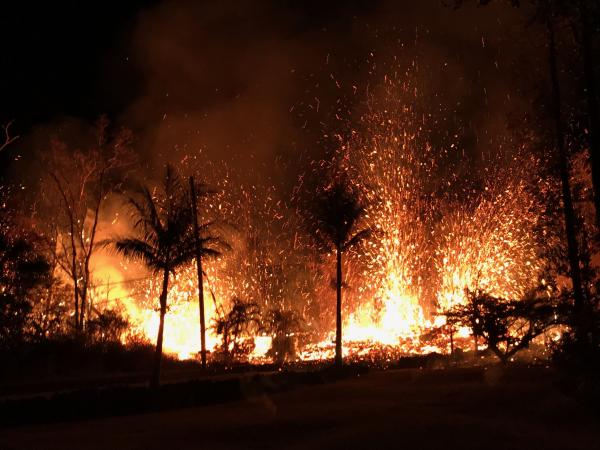
Anyway that is going a bit off topic, so I will leave a picture of the webcam overlooking Leilani. There is definitely a major increase in activity from a few days ago, it almost looks like the sun. Things are really heating up now, no pun intended.
https://volcanoes.usgs.gov/observatories/hvo/webcam.html?webcam=PGcam
Wrong link…
I have heard about some potential links with geothermal plant and EQ (paper : ” the November 2017 Mw 5.5 Pohang earthquake: A possible case of induced seismicity in South Korea – Science 26 apr 2018 – authors from ETH, Postdam and Galsgow).
Then rises the following question….
…. What about the risks between geoplant and rift zone / very active volcano
The geothermal plant didnt induce the 6.9 earthquake that happened the other day, that was probably going to happen anyway within the next few years and the intrusion triggered it. The danger to the plant is that if the intrusion goes near the well then it *might* use a borehole as a vent and destroy the system, leading to it being unusable and at high risk of more eruptions. An eruption happened through a borehole in the krafla fires eruptions in Iceland in 1975-1984, so it should be able to happen here as well, in theory.
The fissure in leilani is very bright right now, I think it was fissure 9 or 10 that had the 70+ meter tall lava fountains earlier, and it seems to still be going strong. Fissure 7 (the first vent to erupt a lava flow) started constructing a low chain of cinder/spatter cones before it stopped, my bet is that the same thing is happening at whatever fissure is making the glow now. If this lasts a bit longer then it will probably narrow to a single larger vent and more significant lava fountains and flows will likely start. The drainage in that area goes northeast to the coast about 11 km downstream so an ocean entry is a good possibility if a big flow starts. If vents open uprift then the slope is a lot steeper and a flow will likely reach the sea within a day or two, same with any vents near kapoho crater.
Dunno if I would call killing a drill bit and a section of string an eruption. The magma was not under pressure.
Well some of the lava ended up on the surface, so technically it was an eruption, even if it was completely artificial. This happened during the krafla fires, I dont remember what year. The one you are talking about happened in 2011.
🙂 lol, unrelated:
** Magma flowed into an exploratory geothermal well at 2.1 km
depth being drilled in the Krafl a central volcano in Iceland, creating a
unique opportunity to study rhyolite magma in situ in a basaltic envi-
ronment.
** In 2005 drilling in the Puna geothermal fi eld in Hawaii encountered dacite magma at 2488 m depth (Teplow et al., 2009). That well was eventually completed as an injection well 2124 m deep, above the dacite intrusion
W. A. Elders and al. Origin of a rhyolite that intruded a geothermal well while drilling at the Krafla volcano, Iceland. Geology, 2011; 39 (3): 231
KLUD is showing the harmonic signal again.
Sorry… where is KLUD located?
There is a lava fountain on the webcam at the moment, it isnt dark anymore so you can see the orange of the fountain in the early morning light. Looks like a pretty serious vent now. The harmonic tremor is probably either related to this or is showing an impending new breakout somewhere. There were several main vents in the 1955 eruption, the first was near kapoho crater but the bigges one, known as the ‘T’ vent, happened near the end of the eruption to the west of HW 130, and there were small vents everywhere in between. Pretty much anywhere between pu’u o’o and kapoho is probably at potential risk of an eruption.
Pu’u leilani is growing…
which webcam are You refering to? or as sticklers would have it=== To which webcam are You refering? 🙂 motsfo
Just south of the leilani estates subdivision. Folllow moku st. south and on the other side of PUU Kaliu which looks like a small cone.
if i’ve been glued to the computer for umpteen hours; where did i get this case of pink eye????? ugh! hurts to blink..nuts…. no grandkids visiting so i can’t blame them…. 😉 sigh…. motsfo
i’m surprised no one replied “Don’t Blink” via Dr. Who….
Too many years since I watched Dr Who. It used to be the motivation to get to the house in a timely manner after work. It tended to start off spectacular evenings of partying just off of El Cajon in San Diego.
i don’t watch Dr. Who……. but the episode “Don’t Blink” is one of the most crafted time travel stories and not to be missed………. You will thank me……. 🙂 Best!motsfo
I was on the soccer fields for 10 hours yesterday and had major withdraws. Heading back out for several more hours now. Be back later.
Mac
An overflight from yesterday.
[Redacted]
It was an unsubstantiated and unverified report that does not mesh with notifications from official channels.
Contact GeoLurking if there is an issue with this.
For the other moderators, the full text of the redacted post can be found in … well, you know.
For all. Alarmist comments are not allowed on this site. Any comment oriented to specifically cause consternation or alarm will be redacted. More severe sanctions can be invoked if it becomes a common behavior. Personally, I’m pretty sedate. But if you tick off the site owner, standby for real fun.
→ GeoLurking.
This twitter account sounds 0% credible. If it’s not coming from USGS or Civil Defense I would be very careful with news about the eruption.
That’s why i posted here. So people can read about it by credible people.
Eh?
I had a look on their website and they appear to be somewhat ‘loony tunes’. Just checked PTWC and they are not indicating a tsunami warning.
perhaps one of the powers that be can clean up the Luisport post….. ??? NOW!!
Done
lavapix.com
@lavapixcom
More fissures. 12 now. https://twitter.com/lavapixcom/status/993189584069476352?s=19
According to Hawaii News Now, an emergency information center has been set by the residents near the intersection of Kapoho Rd and Hwy 130. (due to dissatisfaction with the flow of info from the county)
Reportedly, they are stocking up on supplies (including pet food, blankets, some clothing, and baby formula). One disturbing thing I learned from the Travis Sanders live feed a couple of nights ago, is that some residents had left their pets locked in the homes as they evacuated. THAT, is just completely in-human. If anyone does that, they deserve any property damage they get. Provided that the pet gets rescued. I’ve done 500 mile evacuations due to hurricanes AND taken my pets with me. Pets are part of your family and deserve to be taken care of. They give you unconditional love and look to you for taking care of them.
And the link to that news broadcast: http://www.hawaiinewsnow.com/clip/14327005/fissures-9-and-10-open-in-leilani-estates
I suspect there’s also a strong correlation between cruel idiots who leave their pets locked in their houses and suicidal idiots who then later decide that they want to go back and get the pets.
You’re probably correct, but I don’t want to do the analysis of that data. Sounds like a job for the WHO or CDC.
Not only pets but Livestock and in particular, Horses… simply opening a barn or corral gate is better than driving off.. Saw that on a couple of fires i worked…
[* Shield plugin marked this comment as “spam”. Reason: Failed GASP Bot Filter Test (checkbox) *]
If you cannot bring your pets release them animals will survive on instinct,
lavapix.com
@lavapixcom
·
26 min
New fissures appear to burning structures. Fountain is huge as you can see it in this image.
https://twitter.com/lavapixcom/status/993199570816458752
NOTICE: N95 particulate masks are ineffective for protection against noxious volcanic gasses. The only officially recommended equipment are self contained breathing apparatus. (SCBA). From experience, I have found SCBA are only good for about 30 minutes of use. These are the air bottle units you commonly see firefighters use. Allegedly you can get 60 minutes of use, but I have seen some people suck a bottle dry in 15 minutes.
Theoretically, an OBA (oxygen breathing apparatus) could suffice, but those are generally only found and used on Naval ships. Specific training on their use is needed. They also pose an explosion hazard if you toss your spent canister into oily water.
A non officially sanctioned mask would be the chemical filtering canister masks, but they are generally only meant for VOC – volatile organic compounds, such as paint. They are not designed to deal with volcanic gasses. These would be the carbon filter variety.
An emergency work around would be a damp towel over your nose and mouth, but this affords no protection for the mucus membranes of your eyes. This is only intended to give you enough time to get clear of the gasses.
What are in the gasses that is so dangerous? Mainly SO2. That turns into
sulfuric[sulfurous] acid when it reacts with moisture. As for housefires, well, then you get Hydrogen Cyanide (From carpets and furniture), potentially Phosgene gas (from burning air conditioners), and other nasties as stuff not intended to burn, burns. Even the tin can react with other material and make organotin compounds, which can be nearly as effective as cyanide in killing things.Factoid. Most house fire fatalities are from someone hopping up out of bed and gasping 800° air and burning their lungs. STAY LOW and get the hell out of there. There tends to be a pocket of breathable air within about 4 to 6 inches on the floor. Yeah, you’ll look stupid, but no one is gonna be there to see it and it’s better to look stupid and live.
Definition of apparatus
“plural apparatuses or apparatus“
Old fridges also contain compounds of carbon, fluorine and chlorine (basically CFCs) that are very stable at room temperature but can react with oxygen and water at high temperature to yield things like carbonyl fluoride, carbonyl chloride (phosgene) and hydrofluoric acid, and I would suspect that they can react with sulfur dioxide too to make sulfur oxyhalides, which are probably worse – thionyl chloride (SOCl2) is an internationally illegal weapon of war that will land you a prison sentence for possessing in most places. Gives you an idea of how many things around your home can turn into things that can kill you when they end up in hot places.
I wouldn’t worry about organometallics though, 90% of the time they are pyrophoric and the ones that aren’t will burn easily (sometimes they are added to petrol to make its octane rating higher), so I don’t think much of those will result from a house being destroyed by lava, not that it really matters anymore at that point though…
I only mentioned the organotin because I was making bronze today and had time to kill reading about tin.
THANK YOU for the additional information! It serves to hammer my point. 😀
Not true on the SCBA. There are ‘acid gas’ filters made specifically for situations like this, where gasses like SO2 are the main problem. I used them at the Holuhraun eruption, and when camped on the edge of the crater at Marum (gassiest place I’ve ever been, far worse than Holuhraun; etched the glass of the screen on my phone!)
Here’s my ‘effusive’ eruption kit; includes half and full face masks (it’s no good being able to breath if really serious gas conditions means you can hardly see!):
My SCBA info was based off of what the news people were broadcasting from a spokesman.
Your gear set-up advice is more sound since you have actually used it in field.
Note my post above on masks. There are masks available which will handle reasonable levels of SO2, several manufacturers make them, here is one:
http://multimedia.3m.com/mws/media/40744O/3m-respirator-cartridge-and-filter-selection-poster.pdf
OV/AG type would work but note these are really not for going into really high levels (10% ish?) where they would rapidly be overwhelmed but they ought to do for escape or where levels are more modest or more of an inconvenience.
Otherwise lurk’s advice is worth remembering, one day you may need to use it in normal life, and tell your family too.
Seconded, good old navy fire fighting training wisdom being dispensed here. yours Aye
Please GeoLuking, SO2 forms sulfurous acid (H2SO3), not sulfuric acid (H2SO4). The spelling is not much of a difference but the result is…H2SO3 is less acidic and less stable.
H2S is mostly the bigger problem, it is poisonous in low concentration, but smellable in low concentration, so if one smells rotten eggs it’s time to get out of there.
As for the gasmasks: I’m not familiar with the american terms, but a (better large) filter for acidic gases would be necessary, as it not only removes SO2, but also H2S and HF from air. But this is only to get out of the area, as the filters deplete quite fast.
@turtlebirdman: if there is any water (air moisture) or temperature above 80°C, there won’t be any thionylchloride.
GL Edit → requested changes made. Do I have to balance the equation every time I refer to it? 😀.
If you write it down in words – no. ;o)
Sorry for beeing such a nerd ;o)
With all eyes on Hawaii some may be interested to see the spacewalk taking place right now on the space station. https://youtu.be/RtU_mdL2vBM
lavapix.com
@lavapixcom
1 or all of the new fissures/flows are advancing towards Pohoiki RD rather quickly.
https://twitter.com/lavapixcom/status/993220613799002112
J H Gurney
@UKEQ_Bulletin
A damaging & intensifying earthquake swarm is striking the western shore of the Fonseca Gulf, on the border between El Salvador & Honduras. The following seismograms (from Tegucigalpa, Honduras) show a Mw 5.2, Mw 5.3, Mw 5.4 & Mw 5.6 (magnitudes courtesy @ALomaxNet) #sismo
https://twitter.com/UKEQ_Bulletin/status/993210032677359616
For those of you who take issue with the distractive most recent Central America quake report, do note that it forced me to revisit some excel tricks that I haven’t used since the appearance of “Bob” at the Canaries.
As for the comment, yes, there is an increasing trend in the quakes there, and there is a decrease in depth over time. My guess is that the strata is readjusting to the larger quake along the subduction zone. Similar to the off shore quakes in Hawaii being a response to the 6.9.
Updated fissure map. Getting longer and longer.
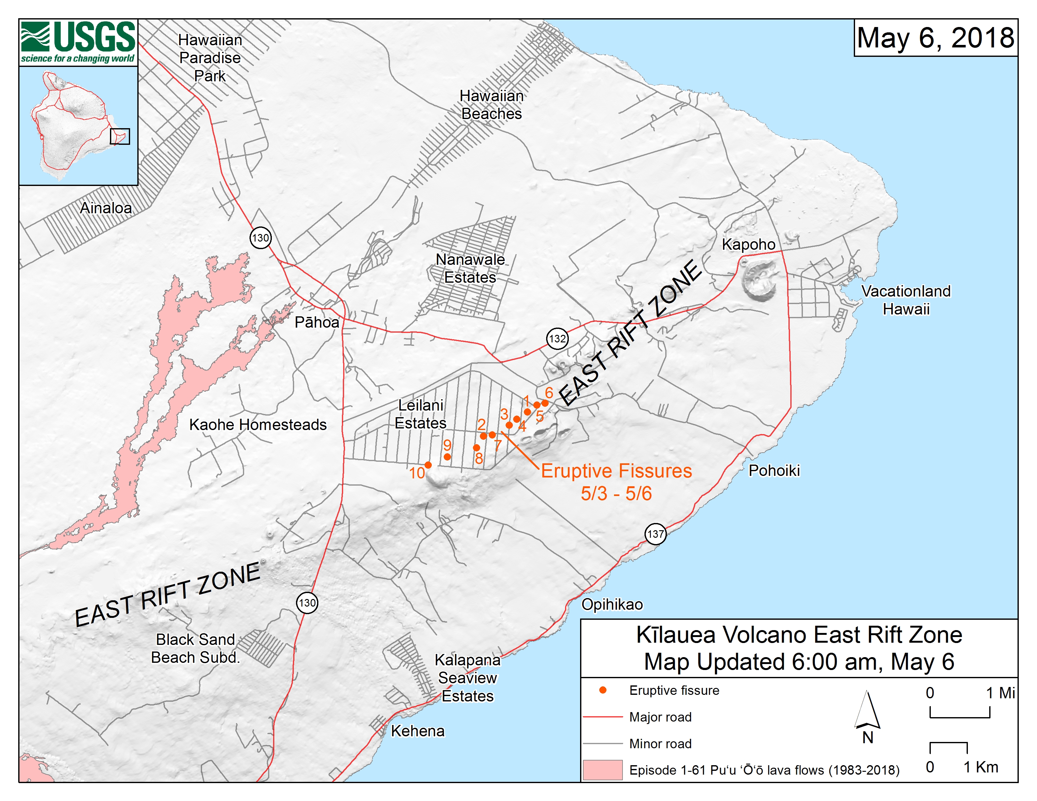
What concerns me, is that the most vigorous activity has been with the latest two breakouts. 9 and 10. This could be indicative of the main charge of magma coming down the system since those two are the more westward portions of the fissure line. Activity at the already existing fissures could resume or increase in intensity.
Yes i agree with you. I have seen the cam from eruption site and it seams stronger and more active.
Based on the commentary of the Travis Sanders entity in his live stream from the other night, it could get quite nasty. Evidently he’s been through this sort of thing before.
The lava that comes out seems quite viscous when compared with the famous firehose or with the stuff that’s been slushing around in the summit lava lake.
Is the lava that we see now actually old magma that’s been sitting in the rift and evolved since the last downrift eruption? If so, can we expect less viscous lava and a more intense flow as time goes by and the evolved magma is replaced by more juvenile? Every time a new fissure opens up it seems more intense and the lava flow reaches further than previously. Can we in the end get Jesper level fluidity (hope you know what I mean by that) or does the magma cool off too much since it has to travel so far down the rift?
I dunno, I also heard him mentioning a large eruption at the summit a la the movie 2012.
It is interesting to note what happened in 1868. The main shock of ~7.9 was preceded by a 7.1 five days prior.
The worsening of harmonic tremor underneath Kilauea is also showing up under some of the Mauna Loa seismographs. If there is to be an escalation of activity, it would seemingly be likely to come within the next week or so, if history is any guide.
https://en.wikipedia.org/wiki/1868_Hawaii_earthquake
A sequence of foreshocks began on March 27, with tremors every few minutes. They increased steadily in intensity, including one on March 28 that had an estimated magnitude of 7.1. The sequence continued until 4 p.m. on April 2, when the mainshock occurred.[3] One interpretation of this sequence of events is that they were related to the movement of two separate landslide structures on the south side of the island. The first, triggered by an eruption that began in the upper part of Mauna Loa’s southwest rift, involved movement of a block that extended seawards for at least 12 miles (19 km). The tremors over the next four days are regarded as aftershocks of the 7.1 event caused by this movement. The mainshock involved movement of the entire southern flank of Kīlauea on the basal detachment at an estimated depth of 9 kilometers (5.6 mi),[9] and was probably triggered by the earlier event.[3]
That makes those 10 km depth quakes a bit worrisome. Not helping that is that the data pulls that I am getting from USGS have wonky lat-long values though I am centered on Hawaii.
Look at this… I wonder if it is a precursor to the larger event in the next day or three?
Also PHOD has a drunk seismometer but it is now picking up the same harmonic tremor… it was not before…!
It could be that slug of magma coming down the conduits.
Why does everything have to get worse before it gets better?
Yesterday i saw on news that geologists are worried with lava drain too much and fast on main volcano and water table enter on volcano and make a steam explosion. What do you think?
The lake drained all the way to the bottom of the crater in 2011 with no steam explosions. You need to do down about 400 meters to reach the water table at kilaueas summit, this happened when it’s caldera formed in the 1500s and again in 1924, but for that to happen now you would need to basically have another caldera formation. The overlook crater isn’t 400 meters deep, and if anything the collapses will probably just make it shallower and more bowl shaped rather than a pit crater as it is now. This might cause lava erupting in it later on to form a perched pond instead of the deep lake that existed before.
Evidence from the earlier calderas shows that they invariably filled to overflowing and stayed that way for a long time before another caldera formed. Pu’u o’o might have been a diverted caldera filling event, which would explain why it is so long lasting. Once the east rift stops draining magma from the summit, the overlook crater will probably fill and overflow again and could manage to fill halemaumau within a few years before flowing into the caldera and south out of the caldera.
That’s exactly what happened in 1924; lava lake drained and water got access to hot stuff; significant phreatomagmatic eruption ensued.
You won’t get another 1868 from kilauea sliding on its own, that quake was caused by the entire south facing side of the island sliding down, which might not be a frequent event. 1975 happened because of kilauea sliding again but mauna loa stayed still, the 6.9 the other day was basically the same as the 1975 quake but smaller because of less total mass sliding. Mauna loa was also in an active period in 1868 which might have been important. Kilauea has been in an active period since 1950 that is still very much at its peak, so maybe the quakes happen mostly in the volcanoes when they are in highly active periods. 1868 was bigger than most because mauna loa is massive and was able to push kilauea with it, while kilauea has nothing to push on in that way.
This recent quake might have also opened up the rift zone in the eruption area, so eruptions in lower puna might be the most likely outlet for a few years time. This eruption might not end up being that big, but a bigger one could happen next year or the year after. A repeat of 1960 now would be pretty bad, but a repeat of 1840 would probably be life threatening.
So far this has actually been a lot smaller than I thought it would be by this time, although the tremors might mean something is about to happen very soon.
REPORTEDLY, there is a window of opportunity for residents in certain portions of the affected area to return to their homes to gather any important items and or pets. (No kids allowed) This appears to be a staged operation and is being done by sections. Prevailing conditions will determine how long this opportunity lasts. Also, there are two of the shelters that are designated as pet friendly.
http://www.hawaiinewsnow.com/category/198303/livestream
So this is probably not good… but also… looks like a lava tube now visible in the drained pic?
https://ibb.co/kZoxzS
If you mean the dark spot on the left… could be. Anyone have information on lava tubes that have suddenly gone inactive? This might have been the source.
That is what I mean! It may be blur but it looks suspiciously like a lava tube.
There is nothing on the thermal cam. Just wall.
might be wrong but wouldn’t a tube leaving in that direction send the lava west??? and don’t take any driving directions from me either… Best!motsfo
Hard to see if you get a picture every 15 minutes. I wonder why we get such a low refresh rate. There are way more remote volcanoes that have better webcam coverage.
It’s probably because the camera is in a very dangerous location, so they don’t want to put an expensive camera there if they can avoid it. The data required for live streaming would be huge too with the amount of visitors they have looking at the activity. If you get 2 million visitors there every year you can bet you have way more than that looking at the cams. In 2011 there were thousands of people trying to watch the kamoamoa fissure when it was active, what is happening now is basically the same thing but in an inhabited area with easy access, live streaming the lower east rift cam now would cost a small fortune on its own.
I think the thermal camera is at a different angle than the video. If you orient the pattern of cracks on the surface of the lava between the two images, the “lava tube” maybe that feature right of center on the thermal view.
And I relay from the News broadcast. If you are not a resident of the affected area, STAY AWAY. Your presence chokes the traffic and makes things much harder on the people living there. Especially Hwy 130. They are trying to help the residents get their belongings and you being there messes the operation up considerably. Proof of residence IS REQUIRED at the checkpoints.
The mandatory evacuation is still in place.
As an occasional evacuee (hurricanes), rubberneckers piss me off. If you tangle with Law Enforcement, I don’t give a shit what your excuse is, you deserve it.
Also, the USGS has dropped the official fissure count down to 9. They believe that two of them were connected.
They believe that two of them were connected yeah…. but i don’t think connecting the dots makes it weaker..just makes the out break stronger… i need coffee or at least a nap…. didn’t get my 12 hours last night… Best!motsfo
It looks like JOKA has moved about 50CM south, 10CM East, and fallen by about 35CM… in the past day… are there other sites to verify?
This is *following* the major movement from the earthquake!
I can’t do the same tilt-meter calculations that Albert can and he
is[was] temporarily unavailable. But I see it as in keeping with the ongoing Hilina slump. That thing could take a few thousand years to complete.There will be an effect from the earthquake in there (this is exactly the movement you may expect from the slip). The magma flow in the dike will also play a role. But JOKA is uphill from the activity (in my recollection) and the downward movement seems to fit the reverse thrust. The amounts are not excessive. There is typically a couple of centimeters seaward movement every year, mainly to accommodate the internal growth of Mauna Loa and Kilauea (they keep receiving new magma for which room needs to be made!) No worries.
There is only one access checkpoint letting people into the area. This is so they can keep a head-count in case things go bad fast.
Due to the extreme caution that is being taken, and that they allowed last minute “grab your important stuff” access… I have to wonder if the behind the scenes people see something quite nasty coming down the pike.
The activity already looked to be much more substantial in the early morning, you could actually see the lava fountain towering over the trees. I think it was fissure 10 (or maybe 9 now), which is directly north of pu’u kaliu and the most uprift fissure so far. If the earthquake activity is showing an increase then this could be the big one.
The first vent of the 1955 eruption to make a lava flow that reached the sea started from a spot that is just a bit uprift from this area, on the west side of pu’u kaliu in an area that is completely forested over now and has houses just south of it… I don’t really think there’s any excuse for building a house on lava that was erupted only 63 years ago…
Perhaps hotter more juvenile magma is responsible for initiating the fissures since it found an easier path through the rift area rather than grunt it’s way to the summit crater. Then once it establishes a relief path for the pressure, the system over rides and punches through any blockages restraining the magma column and it back flows down the new conduits, breaking out in the first available hole that the juvenile magma had created.
I know HVO has bigger fish to fry at the moment, but it’d be interesting to see the magma chemistry so far. (Let’s see–a smidge of 1955, a bit of 1952, a dash of 1977, with a glaze of 2018!)
This also sort of fits with the idea that Icelandic dead zone eruptions occur when the stress holding the fissure shut is released as the plates pull apart and then initiates fissure eruptions. In Hawaii, the rift is the boundary of the ongoing slump and it slowly puts the rift zone into tension and make it an easier path for fresh magma coming up from below. If the rift rocks fracture at less than 27,026,146 Pascals, they are the easier path rather than pushing on to the summit. My guess is that convective flow in the conduit fails for some reason and the alternate rift path wins the argument about where to go.
Pre-eruptive and post-eruptive Seismicity in Hawaii big Island video in 3D. Elevation is exagerated by a factor of 1.8. The color of the hypocenter events corespond to their age as well as the liberated-energy/time left bar.
https://youtu.be/XMmcX7Ufqp8
i’m thinking people might have left their pets to “protect” their “STUFF” and that’s why they didn’t take them. i once had a dog that beat me to the car when i was leaving a fire…. who’s a good dog… ?? well he was’nt a good dog… just into self presevation…. when leaving the fire zone he would bark ferociously (sp) everytime i stopped to tell someone else about the fire…… imagine a strange woman pulling up in Your driveway with a deftening dog howling like a banshie to the dog to shut up(strange woman doing the banshee thingy)…. i still laugh till the tears come thinking about it. Can still remember their stunned faces….
The last time I had to evacuate (Wife mandated) I had smaller dogs. I havn’t had to drag this tooth monster across country with me. I think he would be okay, he really enjoyed prancing around in my van the other day on a trip to UPS. After a while, he just sat behind the center console to check out the view.
I want to ask this…what’s the deepest earthquake that’s occurred since the draining of Pu’u O’o?
Also, I remember reading somewhere that before or during the 1955 eruption, there was an EQ (can’t remember the magnitude) that originated at a depth of 55 km. That sounds rather deep to me. I wonder what could’ve been happening this far deep below the surface?
Feeder system quake. The whole island chain sits on top of a hotspot.
Very cool!. Deepest quakes seem to be under Mauna Loa, I guess that is not surprising.
There have been deep quakes there but the majority of the deepest quakes are south of Mauna Loa, along the coast. That is where the magma appears to be coming up before deciding which volcano to feed.
Thanks. It may not be up to 2018 but still shows important info.
0.9km Lava flow according to USGS travelling north and 21 homes destroyed but inflation is getting smaller in the fissure area.
https://twitter.com/AP/status/993274820992356354
https://volcanoes.usgs.gov/volcanoes/kilauea/status.html
The inflation Ja gettin smaller probably because the eruption rate at the fissures is approaching the rate of feed from the summit. The fissures up until fissure 7 were basically gas vents, they erupted almost no lava but sent whatever they did erupt flying. This is basically what happens at stromboli.
Fissure 7 was the first vent to actually get somewhere, it constructed a small cone probably about 20-30 meters high and involved short lava flows. Now there is a fissure that is erupting a longer flow, so there is not as much pressure as before and the eruption might stabilise at this vent for a while.
The new lava flow travelled 900 metres in 5 hours so it could be in the ocean in a few days if the vent stays active. I guess with all the fissures opening up one of them was bound to capture the supply and get bigger.
Apparently the lava flow is erupting from fissure 8, not the newest one that was very active yesterday (70 meter lava fountains), so the flow will miss the majority of the estate at this moment. It might flow through some other places though on its way to the sea. I know that the situation is difficult for those involved, but as an outsider I can’t help but be interested in what will happen tonight. Might be worth investing in my Lava Castle^TM idea if you live in lower puna but off the rift zone 😉 as long as the flow isn’t dammed it will just go around things easily, lava usually moves too slowly to have a lot of impact on things in its path, it’s not like a raging flash flood (usually).
Based on the KLUD drum plot, my guess is that when the “main event” happens, it may yield upwards of seven and half hours of vigorous activity.
And, if my supposition about the dynamics are correct, the most westward fissures will be the most active.
Note: I am NOT a geologist. This is just idle speculation. My logic is that the first open vent that the magma “slug” from the upper summit runs across, will be the primary one that it uses. This does not rule out the possibility of the fissures extending to connect to each other. Also, using the closest vent seems to be supported by historical activity and my “speculation” is just someway of explaining it. No verified scientific evidence supports my idea.
Reportedly, they had to secure access because of congestion in the affected area. Just too many people in the area to maintain safety.
And if you are a rubbernecker that snuck in to see the fissures, I wish you great misfortune. I encourage you take your P95 mask and go into the fume and check out the sights.
According to the news feed, non residents are congesting the area. Since the Governor made it a disaster area, I think the Hawaii county PD should START ARRESTING people. Why? Interference with emergency services… or as a potential looter.
Also note, that not all residents will be allowed in due to the conditions present near their homes.
And yes, traffic accidents are occurring.
Hawaii County Police and Fire – East – Big Island Hawaii via broadcastify.
https://www.broadcastify.com/listen/feed/28068/web
Is my idea about arresting people a bit draconian? Yep. Fully so. You self centered little shit thrill seekers deserve to get your jollies BEHIND BARS.
Yes, we thrive on things volcanic, but the vast majority of us do so at a distance and do not interfere with peoples lives.
My Axiom for surviving a volcanic eruption is DON’T BE THERE. These people have been forced from their homes and they have a short lived chance to retrieve important items from their homes. Don’t mess that up for them. If you don’t live there, and you are there, you are in the way. YOU ARE THE PROBLEM. And, don’t forget… karma can be a real pain. Are you sure you want to dance with it?
Its where exclusion zones are good, just being in the area without authorisation means a criminal record and a fine (min). Publicised on TV&Radio nobody has an excuse not to know. It can be big enough that there is no point going because you won’t see anything, better to watch TV.
Come to Germany, we have a law against rubbernecks. Either a heavy fine or up to one year in prison…
https://dejure.org/gesetze/StGB/323c.html
§ 323c
Failure to provide assistance; Disability of assisting persons
(1) Anyone who does not help in the event of accidents or common danger or distress, although necessary and reasonable in the circumstances, in particular without significant personal risk and without breaching other important duties, shall be punished with imprisonment of up to one year or a fine ,
(2) Also, those who in these situations are hindering a person who seeks to help or render assistance to a third party will be punished.
The Lower Puna webcam is showing lots of dark smoke from an area extending towards the right.
This looks like it could be a lava flow, with the dark smoke from vegetation, structures and roads being burnt in it’s way.
I have been watching this over the last few hours and it has been extending gradually further and further to the right. (Northeast, by my reckoning)
Emergency services just dispatched a unit to investigate a “strange smell” in someones basement on Leilani avenue. If it turns out to be volcanic gasses… well, that’s not good. It was described as some sort of “chemical smell.”
Note: PVC piping gives off a pretty nasty chemical smell as it heats up and begins melting.
The smell of sulphur and/or methane would both fit that description remarkably well…
I still remember from my childhood, my dad and I were using sulphur to fasten steel fence posts in a concrete containment wall.
Simple procedure, just melt the yellow powder, wait until it turns a nice amber colour, and then pour it into the hole, around the fence post.
Simple enough, until you get a whiff of the stuff as it starts to melt…
Only one word can describe that smell: “Unforgettable”.
sulfur can’t melt in the presence of oxygen without catching on fire, and it burns with an almost invisible flame so you can’t really see it in the day, which probably means the flame temperature is really high.
I found this out the hard way when we tried to melt it at school a few years ago and no one could go in that corner for a while, we didn’t do it in the fume hood because we thought it would only catch on fire if touched by an open flame……….. Nah.
Methane is odourless, its why smell is added to natural gas.
Yeah… the bit that has me curious, is that I thought that this area had mandatory evacuations. If this is one of the people let in to retrieve belongings, they may need to just get their stuff and go.
That window of “get your important stuff” is supposed to last until 1800 local time there.
The responding unit reports that the smell has dissipated and that nothing was found.
That is the lava flow HVO are talking about. It started around 5:00 AM Hilo time, and 5 hours later it was about 900 meters long. At that rate it could be over 3 km now if it has continued advancing. The drainage it follows will lead it to the ocean about 11km from the vent, to a spot that is just south of where the 1840 flow entered the ocean.
This is a great video taken by Mick Kalber. It was taken probably around 6:00 or 7:00 in the morning so the flow is a lot longer by now than it shows in this video.
I think he basically owns that helicopter by now, those flights aren’t cheap and he’s done one almost every week since the Pahoa flow was active, not counting the daily stuff now. Must be some sort of epic deal that he has.
Probably one of the best jobs anyone who likes volcanoes could have 😉
That would be consistent with what the PGCam is showing. I’d estimate that at about 2.5km from the vents, but I could of course be way off the mark.
Well if the flow is advancing slightly towards or away from the cam, then it will look a bit shorter than it actually is. I think once the flow exits leilani it actually goes past pu’u honuaula (where the cam is) quite closely and it looks like there is an open field there so it might be a good view of the flow. HVO pictures show it as a proximal a’a flow, which basically means it is the fastest moving sort of lava flow right now.
An 11th fissue is showing on https://www.google.com/maps/d/u/0/viewer?mid=11tCiLa42FId7GMtg-4UkEoAI9QozTVFD&ll=19.47818884147605%2C-154.89479178834608&z=15 in a location that seems to fit very well with what PGcam is showing.
The camera is also showing fountaining/spattering in that location.
Has this been officially confirmed?
If so, this fissure would be offset from the others, which are all more or less in line.
The new fissure is showing in the general area where I was thinking the lava flow front would be.
It is probably caused by fire from something like that. I dont see any fountaining on the webcam but I do see the lava flow. It looks like the flow might have mostly stopped though.
All the tiltmeters show effects since the M6.9. This one at JKA moved the most. A couple started moving before the big jolt.
The PGcam switched to black and white, giving a better idea of the lava flow. Looks like it’s about to reach the open field to the right of the camera.
someone the link to the pg cam please 🙂
This was held by the spam deamon for approval, as tends to happen to new commenters. Future comments should appear without delay – admin
It can be found on https://volcanoes.usgs.gov/observatories/hvo/webcam.html?webcam=PGcam
Hi, do any of you have the approximate latitude /longitude co-ords for the PGcam?
Thank you.
It is on pu’u honuaula, which is downrift of leilani estates and just behind the geothermal plant.
Thank you, appreciated.
Looks like a 3.9 and 4.0 both 300M ASL @ Kilauea. The harmonic signal is beginning to appear for more Mauna Loa seismograms as well though? Rather, it appears to be gradually shifting west from KLUD/PHOD, though another pulse from the east is also apparently starting to show on both of those sensors.
PHOD is increasingly abstract but harmonic tremor again worsening.
I think something has gone very wrong with this seismograph… Where is it located?
Pahoa, among the locations worst affected by harmonic shaking, perhaps it is affecting the instruments?
The seismograph itself seems to be fine. I think its a glitch in how the data is displayed by the computer. Annoying but nothing of geological importance.
looks like a paper jam.
Also tiltmeter SDH @ Kilauea is showing a drop even larger than what preceded the last big quake… it is this discord between what has been released to the east and what has subsequently been transferred to the west that will ultimately result in a larger quake, if we do have one (IMO).
I reckon it’s been shook up a bit too much, recently.
Maybe the big quake the other day pushed it around a bit and it has been falling over since then, or maybe someone kicked it accidentally and it fell over. Pahoa isn’t right on the rift zone so there wont be eruptions happening under it, but faults probably go close enough to it for there to be deformation during big quakes.
Maybe the machine is fine and something went wrong with how it is projected on their site. It looks like it is still recording fine just with really weird angles… Probably an electronic problem somewhere (not unlikely with the recent quakes).
So what happened in the last 11 minutes to make PHODs tremor jump in amplitude?
The lava lake in the overlook crater is very deep now, but it also looks like it has become much more violently convective, like the lava lakes at ambrym. I dont think I have ever seen that sort of glow from the vent before today, even during other draining events. Maybe when the rift zone calms down eventually, the overlook crater will erupt again but it might be a lot more vigorous than before.
The magma supply to kilauea is apparently at a very high rate comparable to when it was first filling in its caldera in the early 19th century, about 1 km3 in 7 – 10 years, so the chance of this new eruption being the end of activity at kilauea is very unlikely as to be almost impossible. Even if everything stops after this eruption in leilani, there will be another eruption on kilauea within a year of this one (probably on the lower east rift again), and probably continuous activity at the overlook crater for decades into the future, like the lava lake prior to 1924. Pu’u o’o will probably erupt again too as it is still directly connected to the magma chamber, though a new eruption probably wont be the same as the way it was erupting up until this year.
Consequently, mauna loa might stay dormant for quite a while longer, with maybe only one or two more eruptions at most before the middle of this century. It was likely almost inactive for a pretty long time (probably at least a century) leading up to 1843, and the only reason this current dormancy is unusual is because historical time started shortly before it started going into high eruption mode, so to speak. The second half of this century might be mauna loas time in the spotlight, but its going to sleep for a while longer.
i think the cams are on ‘night mode’ which might change view.
There was a magnitude 4 earthquake at 0.2 miles deep right under the very upper east rift zone within the last 2 hours, if the depth is correct then this is an interesting event. It is just a little bit downrift of the July 1974 vents from when mauna ulu stopped erupting. I’m assuming the depth will change but that isn’t a certainty.
Got a link to a moment tensor solution? (Beach ball)
This is the GPS data for the last 5 years at uwekahuna bluff near halemaumau. So far the deflation that has happened has been about 50 microradians (about the same as the inflation before the overflows started), in 1955 it was easily 150+ and in 1960 it was well over 300… There was probably also a lot more magma stored in the rift zone before now than there was in 1960 so this event is far from over. May guess is that eventually a more serious vent is going to appear, possibly somewhat uprift of the area now, and sent a big flow south into the ocean, much like in 1955.
I think the reason for the seemingly decreasing output from pu’u o’o was because more magma was staying in the summit than leaving, while the magma supply rate from the mantle was constant. The overflows in halemaumau were pretty substantial and I’m willing to bet that a lot more lava erupted there over that couple of days than was erupted at pu’u o’o over that time. Its pretty obvious that there has been a lot of inflation over the last 5 years and probably most of that is going to drain out down the rift in this activity, if it doesn’t then another eruption will probably happen in the lower rift within a few months to years and finish it off.
I think you are confusing microradians with meters re: UWEV?
Also, of note: the graph has updated since your posting, so even that is interesting. It appears the 4.0 has been of substantial impact, as the site just moved 8CM East, 10CM South, and dropped about 5CM as well.
via
https://volcanoes.usgs.gov/observatories/hvo/hvo_earthquakes.html
Plot says meters…
But, I do know the tilt meters are in radians. Yet one more thing to hurt my wee brain.
1 microradian is equivalent to moving a 1 km bar up one millimetre. So you can convert microradians into metric measurements directly. The 1960 eruption caused the instruments at HVO to drop by 30 cm, but HVO isn’t over the magma chamber so the amount would have been much higher at halemaumau, which underwent a collapse during that eruption. Since April 2015 the observatory has basically been pushed up by almost 40 cm, which is really significant when there is an outlet already active on the flank. As far as I know there was lava flowing out of vents on pu’u o’o the full 100% of the time since the first summit overflow up to the other day, so there must have been a pretty big change somewhere.
Basically what I am saying is that what we have seen so far isn’t very big compared to what it could be. If activity stops in leilani then it will start somewhere else shortly afterwards and not stop, there is too much magma available at the summit for it to not break out again somewhere. 1955 had periods of several weeks between some of the eruptions, so it is pretty unpredictable.
Um, a radian is an ANGLE, about 57 degrees I think but there are precisely 2(pi) radians in 360 degrees. Its the ratio between the radius and the circumference. So a microradian is really tiny, about 20 thousandths of a degree or 0.2 seconds of arc.
I am going off what HVO said on their old website, that one microradian is equivalent to lifting a 1 km bar up by 1 mm, 50 microradians would be 5 cm. The amount of inflation that has been observed since 5 years ago is 0.45 meters, which is 45 cm, or 450 mm which is +450 microradians. Basically if you dug a half meter deep hole on uwekahuna bluff then the bottom of that hole is at about the elevation of the ground in 2013, and uwekahuna bluff isn’t even above the magma chamber – a GPS on the south rim of halemaumau would show much more. That is a big change in only 5 years, especially on an already erupting volcano.
The deflation during the 1960 eruption was about 300 microradians, so what has happened so far is not much yet, which is why it is unlikely for this activity to end without a significant eruption. That eruption might be some weeks in the future if previous eruptions are anything to go off, there might not even be any eruptions for a week or more at times. I would guess that the next eruption will be a bit more uprift, as the end of the dyke seems to be not fed anymore so everything is backing up somewhere.
Not entirely sure of this, but I think some of the evacuees are setting up a small tent city just outside the evac zone near a pizzaria and a bar.
Jimmy Buffet would be proud.
When life gives you lemons, have a Corona. If you get limes, it’s margrarita time.
https://youtu.be/hdMfCNyeGg0