Have you ever been bitten by a dinosaur? That would be something worthy of Jurassic Park. In those movies it tends to be a lethal experience. But most children will get bitten by the dinosaur bug at some point in their early years. Dinosaurs fascinate; it is the excitement of a lost world, a wild place with unimaginable animals. I am the proud owner of a clutch of fossilized dinosaur eggs. Children are drawn to those eggs, with many recognizing them directly for what they are. Museums showcase dinosaur fossils – the large friendly dinosaur with its tail bones stretching along the floor is the first attraction you will see on entering the National History Museum in London. In New York, the Museum of National History similarly impresses but with a far more aggressive-looking fossil reaching far above the impressionable (and feeling very edible) public. For many, the dinosauric fascination continues into adulthood. Some become paleontologists, studying the fossils in the field. Rich people buy the fossils, showing that an abundance of money can feed the child inside. I understand them well – why else would I own those fossil eggs?

American Museum of National History, New York
There are many sites in the world where dinosaur fossils have survived. Sometimes it is not the dinosaurs themselves but the impression they made which survives. Dinosaur footprints can be recognizable, where the massive animals depressed the surface. Soft tissue sometimes survived by impression, which is how we know about scaly skins and in some cases, feathers. Egg shells have already been mentioned as a dinosaur remnant. But mostly it is their bones, sticking out of an eroding rock.
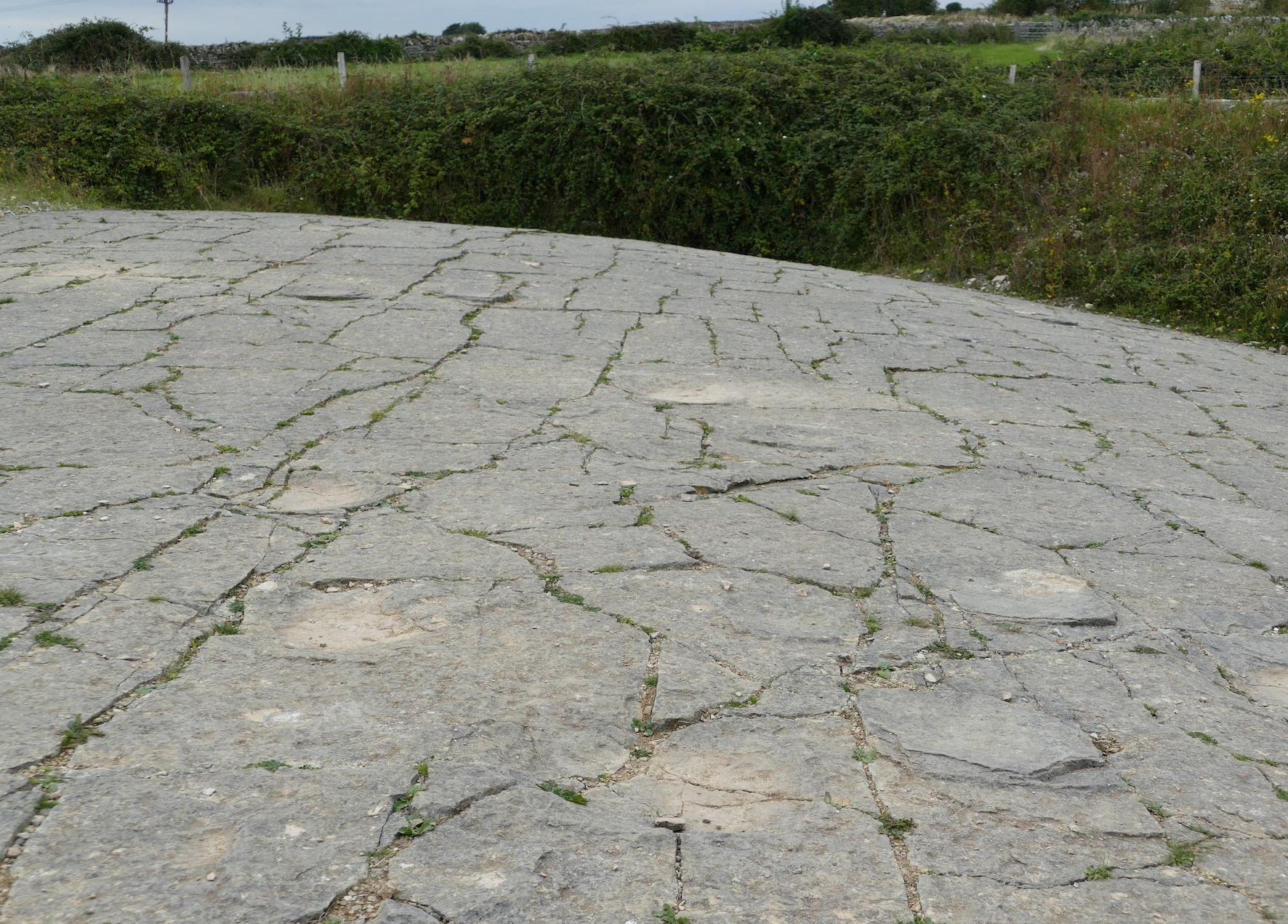
Fossil dinosaur footprints, Spyway, England (photo by author). Not much to look at, but great for the imagination! These prints were left 145 million years ago.
One of the best places to see the fossils as a tourist is the Dinosaur National Monument, Utah, USA. The site, on the border between Utah and Colorado, is a gem. A viewing gallery covers a large rock wall, which at first impression is a jumble of irregular rock. A longer gaze reveals patterns in the jumble, which resolve themselves into petrified bones. Every square meter of the wall has several such bones sticking out. It is in effect a near-vertical dinosaur cemetery, the place where the old dinosaurs went to die. Excavations are still on-going, more than a century since the original discovery. If you are lucky, you will see people excavating in front of you, the paleontologists on display together with their finds. This museum is alive with the past.

The discoverer of the fossil treasure was Earl Douglas. In August 1909 he wrote: “At last in the top of the ledge where the softer overlying [sandstone] beds form a divide—a kind of saddle, I saw eight of the tail bones of a Brontosaurus in exact position. It was a beautiful sight. Part of the ledge had weathered away and several of the vertebrae had weathered out and the beautifully petrified centra lay on the ground. It is by far the best looking Dinosaur prospect I have ever found. The part exposed is worth preserving anyway”. It took some time before the true wealth of the site become clear. By November Douglas wrote: “… the ledge is full of bones… We realize that we have a stupendous task and the men are working like beavers… If we stopped to consider what a terrible lot of work there is to do we might fall over…” The area over which the bones were found measured less than 150 meters in width. The bone layer was strongly tilted, by over 60 degrees, so that bones that were originally spread out horizontally now seem to stack almost vertically. Over the following few years, complete skeletons of an apatosaurus, a diplodocus and an allosaurus were excavated. Animals had died at all ages: there were fully grown adults and young dinosaurs, including a diplodocus only 1 meter long.
Geology
Dinosaur National Monument is much more than a viewing wall, even if the description may give the impression of a Truman show with dinosaurs on a very wide screen tv. This is a national park which covers a large area, which is begging to be explored, although far harder to reach than the visitor centre with its car park. There are dinosaur remains in several places. But those are only one aspect of the park. The landscape is varied, with rocks and layers dating from a billion years ago to the much more recent past. When hiking here, or taking a river trip, you should try to take a geologist with you to explain the landscape. Rock watching may not sound as exciting as bird watching, but the Earth has spend a long time putting this place together. It is a work of art and should be given the attention it deserves, even if the view hasn’t changed much in the past 30 million years. You are not here to watch paint dry. You are admiring the end product.
But in spite of the geological riches, people are drawn mainly to the big friendly (or not so friendly) giants of their childhood. Of all those different geological layers, dinosaur remains are present in only one: the Morrison formation. This layer is a relative newcomer in the region. History here starts about a billion years ago with an ancient mountain range. It wasn’t exactly at this location, but nearby: as the rain weathered the mountains, the sediment came here. This bottom layer is a dark rock called the Uinta Mountain Group (it is named after the local mountain range of modern times). Much later, the land sank and the sea came in. The second layer, called the Lodore formation, is a sandstone that was deposited in a shallow sea around 500 million years ago. As the land sank further, 340 million years ago, the Madison Limestone and the Round Valley Limestone were deposited. At this time the sea stretched from north to south across the continent. 30 million years later, as the sea shallowed, the Morgan formation formed. This is a sandstone which forms a series of nine layers, each cycling between red sandstone, brown mudstone and light-coloured limestone. The red sandstone formed when the surface was drier, the others during wetter times. The layers can be seen in the deep canyons of the park. The layering has been attributed to an ice age which kept changing the sea levels. Now the land rose again above the sea. A vast sand desert formed: this left us the Weber Sandstone, 300 million years old, which form thick layers in which the shape of the sand dunes is sometimes visible.
Nothing now happened until 150 million years ago, as the paint dried. Any rocks that were deposited during this time have been eroded away, leaving a gap in the record. Now, a new episode of sandstone came. This is the Morrison Formation, and this is where the dinosaur fossils reside. The age is between 155 and 144 million years ago. The formation is not unique to this park. The Morrison Formation is found across several states, from New Mexico to Montana, along the east side of the Rocky Mountains. If you see a dinosaur in a US museum, it is not unlikely it came from the Morrison. The Dinosaur National Monument also has some fossils from the later Cedar Mountain formation, rougly 100 million years old, but the large majority are from the Morrison era.
Much later, the growth of the Rocky Mountains caused large scale uplift in the region. This brought with it erosion, and canyons formed. Very recently, glacial erosion has added its signature. All these events has left us a varied and deepy impressive park – which few of the visitors will ever see. They had straight for the visitor centre and the famous wall of crumbly rock-and-bone. The people don’t come for the view. They are here to celebrate an ancient Day of the Dead, a visit to the cemetery to keep the memory alive of this who have departed.
At the time of the Morrison formation, the western USA was just beginning to take shape. In Nevada, the first of the highlands were rising that were later to become the Rocky Mountains. This started 160 million years ago and is known as the Elko orogeny – Elko is a lovely town in northern Nevada, once voted the ‘best small town in America’, and recently upgraded to the ‘best city to live in the state of Nevada’, presumably after some population growth had occured. I once spend a few days in Elko and nearby Spring Creek and can confirm it was a nice place! But it wasn’t nearly as nice here during the Jurassic. A subduction zone had formed off-shore, where the Farallon oceanic plate was subducting underneath the continent, bringing with it the first of the Pacific terranes to join the west coast. An Andean-type mountain range formed above the subducted plate. Rivers were flowing east from those mountains with their load of debris, in some places sand, in other places mud to the low-lying land beyond the Elko mountains. This debris was to become the origin of the Morrison formation.

Ecology
The region east of the mountains had become a huge basin, thousand of kilometers long, and watered by those rivers. The climate was subtropical and fairly dry; the land would have been savannah, except that it didn’t look anything like a savannah because grass had not evolved yet. The area was located in the rain shadow of the newly risen highlands, and away from the rivers water would have been in limited supply, although not desert-like. There were lakes and swamps around the river, as in an ancient Pantanal. Plants were abundant along the rivers, with beds of horse tails, and on drier lands tree ferns and conifers. Across a large area of the USA, the fossils of the Morrison show an abundance of aquatic life, such as mussels and snails (both gill and lung breathing).
The sheer number of the dinosaur fossils in this Formation, including embryos, shows that this was a good environment for them. But there was much more than the occasional large dinosaurs. Much of the animal worlds would have looked somewhat familiar to us, with salamanders, frogs, turtles, and small mammals. And crocodiles.
Just like grazing animals on the African savannah, the local dinosaurs may have been migratory, following the rains and the water. In each location, they probably loitered along the rivers, where the salad bar was set for them. And of course, wherever there is a salad bar, carnivores are patiently waiting for their share. They are not after the salad bar: what they see is a walking buffet. The vegetarians would have needed to be careful eaters; any carelessness could be a recipe for disaster.
Dinosaur volcanics
Just like today, volcanoes were active in the western USA. We don’t know too much about them, but the evidence for their presence is clear in the Morrison Formation. Between 25% and 75% of the Morrison Formation consists of volcanic ash! The volcanoes themselves have not survived – this was, after all, a long time ago and much of the western USA has been remodeled as old oceans subducted, new terranes docked, basins formed and mountains grew.
The oldest Morrison beds, between 155 and 160 million years old, have fewer ash layers. They become more common in the younger layers, between 150 and 155 million years ago. After that, the deposits suddenly end. There is a time gap of perhaps 20 million years, before the Cedar Mountain Formation. By that time the Jurassic had become the Cretaceous and the dinosaurs had changed. If you liked Jurassic Park, you would have enjoyed the the Cretaceous: all the best dinosaurs from the movie were from the Cretaceous. But why the missing 20 million years? These may have been removed by erosion. However, it can be difficult to know whether something is missing because it was removed, or because it was never there.
But let’s return to the Morrisons. The eruptions that occurred over those 5 million years were massive. Ash beds in Utah are over 100 meters thick, containing at least 35 separate explosions. The size of the ash beds, far from the eruptions themselves, suggest these were caused by caldera collapses. Where did these happen? The calderas themselves have not been found and weren’t here. The ash was blown here by the wind from the southwest. This puts the calderas closer to the coast. We can envisage a volcanic arc stretching from western Utah and central Nevada to California’s Mojave. Ash can travel surprisingly far. For instance the ash of the Bishops Tuff is 1 meter thick 800 km from the source! This is not due to ash fall which would have been a few centimeters at this distance. Wind and water transported the ash over such large distances.
Some of the ash beds of Morrisons contain rhyolite and dacite, and a little andesite. The oldest beds are less evolved, the Dinosaur National Park lacks these older events. The volcanics may have changed over time.
What triggered the sudden spike in activity in a brief 5-million year period, 150 million years ago? We can only speculate. The subducting slab may have gone down steeper, causing extension in the overlying continental crust and allowing magma to rise. A slip-strike fault may have developed with an extensional component. There may have been a change in subduction direction. All of these may have occurred! In one view, there were alternating phases of contraction and extension in the region, leading to the Elko highlands, the Morrison basin, and further west the volcanic calderas. This side of the Pacific Ocean has long been a complicated place. This has since a long time been the main long-range east-facing subduction zone on Earth. As America is moving west, it is collecting all the debris that ended up in the eastern Pacific, has swallowed spreading ridges, and incorporated microcontinents. The western USA is where the Pacific ocean dumps its waste.
The volcanoes erupted and deposited thick ash over the land, over several millions of years. The ash did not always remain where it was laid down. Rivers took it down into the basin and the ash ended up in lakes and on mudflats. The interaction with water changed the minerals: sometimes clays such as smectite and illite formed, while in another place it might be albite. It depended on the chemistry of the water. Some of the SiO2 in the ash dissolved into the water. This made the local sediment and clays enriched in the other minerals which did not dissolve, while downstream the dissolved elements would become enriched. This alteration makes it more difficult to know what type of magma caused the eruption. The rare earth elements give the best indication of the original magma: they have ratios that are like rhyolite to rhyodacite, but are not as extreme as found for instance in the Bishops Tuff.
The composition confirms that the volcanoes formed in a volcanic arc along a subduction zone. There was no hot spot or spreading ridge involved. This fits with what we know from the geology.
As the ash was subjected to water in lakes and elsewhere, two important elements dissolved: uranium and vanadium. As the ash beds altered, the sediment layers that formed downstream became enriched in these elements. The sedimentary beds of the Morrison Formation are the main source of mineable deposits of these elements in the USA.
The crumbly stone of the Dinosaur Wall formed from sediments, downstream from the ash beds that fed them, which themselves were downwind from the volcanoes that caused them, which themselves were downstream of the subduction zone that caused them. A chain of cause and effect links the Wall to the distant Pacific ocean.
Dissecting the Morrisons
In the Dinosaur National Monument, the Morrison Formation contains several distinct beds, only one of which contains the famous bones. The four beds are called ‘members’, and called Windy Hill (the oldest), Tidwell, Saltwash and Brushy Basin (the youngest) – the dinosaur wall belongs to the last. Windy Hill is a marine sandstone, and was deposited when this was a sea. The others were deposited when the area had been raised above sea level: Tidwell is a mudstone, Saltwash a river sandstone and Brushy Basin is mainly clay, deposited in lakes, floodplains and in a few cases, streams. Brushy Basin contains more volcanic ash than the other members, and seems to coincide with a peak in volcanic activity. This ash interacted with the water and changed into the red or grey claystone which we now see in the landscape.

Sandstones and mudstones of the Morrison Formation. Source: John Foster, Jurassic West, 2020
The dinosaur wall is part of the Brushy Basin member, but it is not a typical part. While the Brushy Basin is primarily clay, the Quarry bed consists of sandstone. It is present only in the immediate area around the dinosaur wall.

The red line shows the sandstone bed. Figure from Brezinsky and Kollar, PALAIOS, 2018, v. 33, 94–105
The sandstone layer, sandwiched between the clays, can be readily recognized in the landscape. The picture (also from Bezinsky and Kollar, 2018) shows the view east from the parking area, with the Brushy Basin indicated, and the Quarry sandstone forming a ridge above the rest. It stands out because the sandstone is harder and therefore has eroded a bit less.

The sandstone indicates a river. The clay may have formed in lakes where the sediment rained down over time, but the sand was brought by flowing water. The streams went roughly northwest to southeast. The sandstone is found along a line that runs almost west to east, a bit over 1 kilometer in length with a series of outcrops. This is not the line of the river: instead the length of the sandstone bed may correspond to the width of the river bed or it flood plain.
The sandstone is not a single deposit. The picture clearly shows layering. Twelve sandstone layers can be recognized. The layers are coarse-grained sandstone, separated by conglomerates of pebbles and granules. As you move along a layer in the (original) downstream direction, the grains become finer. One of the sandstone layers shows up as isolated, rounded features, around 4 meters in diameter, and perhaps half as thick; they are approximately lens-shaped.
The clays indicate the presence of standing water, or water-logged terrain. At other times there were rivers here in a drier environment. It was more complex than a single, fast-flowing river channel. The lenses may have been sandbanks, build up by the river.

A river runs through it
What about the dinosaurs? The abundance of bones is seen in only one of the many layers and in only one location in this layer. They are found near the bottom of the sand, in what would have been the deepest point of the channel. But the animals can hardly have died there. At least 20 individuals of 10 different species are found. That does not sound like a herd and more like panic. In fact, the location is considered a ‘death assembly’: this is not the place where dinosaurs went to die, but is where the dead dinosaurs ended up. It is the cemetery. They died elsewhere, although probably not far away as dead dinosaurs can’t easily move. If you think of a river bed, the largest pebbles move the least distance. Now think of a dinosaur as a very large pebble. It takes a big flow to move one even a small distance. A major water flow would be needed.
A carcass can actually float. This happens during part of the decomposition. Otherwise, they move by sliding. In some cases there is also evidence of rolling of the carcass by water. The completeness of the bones indicates that they fairly quickly became protected against the elements, presumably by being buried in sediment or sand. Many of the bones show insect damage, and there are indications of drying out. There are a few cases of fossilized skin. This suggests an anoxic environment, as may occur in wet soil below the carcass – but only if there is no flowing water. The alternative is a hot and dry environment, but this leads to the same conclusion: although water created the assembly, the dead dinosaurs did not remain submerged. The water went away.
It should be noted that not all bones are together. In addition to the complete animals, there are many single bones as well. We don’t know whether these belong to a few other individuals or are unrelated to each other. On the east side of the quarry, these separated bones are so dense that they would have obstructed the flow channel by capturing the sediment. And above the bone layer is a thin layer containing many bone fragments, some only millimeter size, showing signs of abrasion. They were perhaps moved by rolling across the surface. We do not know how far they would have travelled. We can’t even be sure it was done by water (although likely): abrasion by sand can also be considered.
The discussion has been going on for decades. Was this a river? It has even been given a name: the Quarry river. But did it exist, and if it did, was it here? There was certainly water, and quite a lot of it: the fossils include evidence of aquatic life, such as turtles, bivalves and gill-breathing snails. Some of the bivalves are still closed: normally they break apart after death. This suggest they were buried while still in water. Many though are disjointed, and someties even stacked. This indicates that the shells, including the closed, buried ones, died somewhere else and were brought here later. There was transport from a place with permanent water to here. It is beginning to sound very much like a river. Dinosaurs, however, would not be expected in deep, fast flowing rivers. They died outside of any river, were brought here by deep, fast water that wasn’t there when they died, and after the bodies had been moved here, at some point the water disappeared. The drying out may have taken months (or even years), but it happened before all soft tissue had decayed. Was the water seasonal? Afterwards, the water did not return to the burial site, probably for many years.
There is some evidence for scavenging of the carcasses, but not nearly as much as might be expected. Whatever happened perhaps did not leave a lot of predators around. As the vegetarians and the lost salad bar, so the carnivores and their carvery.
Death on the Quarry River
Before moving on, a discussion is needed on cause of death. This is always hard to certify in the case of fossils, and especially if the fossils are not found at the exact place where they died. Death by predation can be excluded: that never gives mass mortality. Drought has often been suggested. This is common on the African savannah, which is a similar environment. However, the animals tend to be spread out along the vanished rivers rather than concentrated, so this requires that the corpses were brought together after death. Disease can be ruled out as the main cause of death, as this would not impact such a variety of species. Migration can lead to mass mortality by drowning, if the herd feels compelled to cross a river which happens to be in spate. But this tends to happen to single-species herds, and here the great variation of species argues against it.
This leaves two main options: the deaths may have been caused by drought, and occurred over an extended period, or the dinosaurs died in a catastrophe. The former explanation is generally preferred; it explains many of the characteristics including variation in the amount of decay, but requires that the bodies were brought together by a flood. The limited evidence for scavenging may be a problem. For those who prefer catastrophe, the main choice is normally a major flood.
(The option of death by volcanic eruption (pyroclastics) may seem attractive on VC but lacks evidence and a nearby culprit. Volcanic possibilities such as CO2 poisoning (lake overturn) or a sulphur cloud from some volcano have not yet been suggested. I mention it here just to fill this gap still unclaimed by speculationists. And yes, that is a new word. You read it here first.)
Both the drought and the catastrophe require a flood as part of the explanation. That is the only thing most people would agree on – and it agrees with the presence of the remains of turtles.
The power of water
The next question becomes, what kind of flood? There are two main options: an event within a river bed, or a break-out to a flood plain.
Some of the deposits are suggestive of the latter, what happens when a stream breaks its banks and overflows the surrounding land. The illustration below is taken from the paper by Brezinsky and Kollar, 2018, already mentioned above. The first panel shows the situation at the start of the break-out. Next to the river is a splay, perhaps build up by a previous break out or by an abandoned meander of the river. The next panel shows the situation a while later. As the river broke out over the flood plain, several deep channels were formed by the fast flow, levees build up around these channels and soil developed in the standing water around the levees.
In this model, the dinosaurs could have been on the initial splay, overcome by the sudden flood and ended up at the bottom of the deep channel. The mussels, snails and turtles came from the river, and were brought by the flood. Afterwards, the break healed or the river found a new bed, the flooded area dried out, and insects (but few carnivores) feasted on the buffet. And very much later, scientists come and wondered how so many dinosaurs managed to die in such a small area.


Mississippi splay. No dinosaurs
This model explains many aspects, but is not the most popular one. Most commonly, papers argue for an event inside a river bed. A braided river system has been proposed, with many individual channels in a wide river bed. Here the dinosaurs would have gone to the river bed in times of drought, and succumbed due to lack of food or water. They remained where they died. Sometime later, the river flooded and the bodies were picked up by the flood. This idea does not require a dramatic flood, nor that all dinosaurs died in one catastrophe. It is an attractive and plausible model that has been around for a long time. The main argument raised against it is that the sand layers have the coarsest deposits at the top. That is typical for splays but not for river beds. The variations of the structure along the Quarry sandstone is also not expected for a river bed. However, this does not seem a conclusive argument, and the river bed remains attractive. The fact that the river did not return for a long time may be more problematic.
A variation of this model has suggested a meandering river. This combines features of both models and less of a problem with the subsequent drying out. This model was in fact already proposed by Douglas. It is consistent with much of the data. The main problem may be that the animals are proposed to have been deposited on the inner bend of the meander where the flow velocity are small. It might be expected that the largest, least mobile animals would have ended up in the faster channels further out. A braided river or a break-out flood may therefore seem preferred. However, this discussion is continuing and has not come to a final conclusion.
Whichever model is used, it should be able to explain the partly chaotic properties of the sandstone amidst the mud and clay, and the sheer density of the dinosaur remains.

Example of a braided river
After the flood, the remains formed a Jurassic jumble with bones and bodies thrown together in an area of perhaps 100 by 40 meters. Some were quickly buried, either partially or completely. Now the water went down again, leaving some (perhaps all) on dry land. The bones remained close to their position, showing there was little disturbance for a considerable time. They were quickly buried, and the water did not return for a very long time.
Volcanic speculation
The final question should be what caused the flood. We cannot know how extreme the flood would have been. Was it a river flow from months of rain, or a one-off event? The lack of scavenging may make the latter a bit more likely but it remains speculative.
But let me become a speculationist. The Quarry river came down from highlands covered in tephra, during an era of distant but high volcanic activity. Although there is no evidence that a volcano was directly responsible for the mass casualties, tephra is unstable and it is dangerous stuff to have near rivers. A landslide an easily happen, and this can block flow channels and cause water to pile up behind. I wonder about such an event in the Quarry river, far upstream of the park. A tephra landslide could have created a dam. Now the river was blocked and stopped flowing.
If this happened during the dry season, the animals would have been in trouble. They ran out of food and water, and many died. The land was littered with their corpses. The predators also died – there was plenty of meat near the now-empty salad bar, but they also needed their drink and the bar was closed. Vultures would have helped – but these long-distance scavengers hadn’t evolved yet, leaving a gap in the market for dead meat.
Later the rainy season returned, first in the mountains. The new lake rose, and began to overflow the dam. The river returned. But the dam was only made of tephra and it was dangerously unstable. The water eroded it, and as dams do, it gave way catastrophically. A massive flood came down the river. Much of its power was spend before it arrived here, but enough arrived to pick up the dinosaur bodies, overflow the banks, and dump them at the end of the line.
After the flood, the river went back to normal – perhaps, and the channel refilled. But the future fossils were dumped outside the usual channel and after the flood waters had dried, they remained dry. Alternatively, the flood scoured out a new path and the river never returned.

Kenneth Carpenter, Annals of the Carnegie Museum, 2013
This may even have happened more than once. There are indications that the bone beds were build up by three or four events. I don’t know what the evidence is as the paper is hidden behind an insurmountable paywall. Perhaps that disqualifies the evidence – it certainly makes the proposal untestable. It would indicate that the event was not a complete one-off catastrophe, but four events over perhaps 100,000 years is rather infrequent.
Finally, although Dinosaur National Monument is most viewable dinosaur cemetary in the US, it is not unique. There are other bone beds that are equally densely populated. These were large animals, but sometimes events became too much for them. They lived in a world like ours, where events, from volcanic eruptions to floods and droughts, could happen, until the biggest accident of all ended their reign.
Dinosaurs – the end
This all happened while dinosaurs were young. They had been around since the million years of rain, 230 million years ago, when a major volcanic eruption created perfect conditions in a hostile world. Now they were having the time of their life. The Morrison Formation is the largest sedimentary formation in the USA. It formed a paradisical subtropical basin stretching from New Mexico to Canada. Volcanoes in California provided a regular dusting of fertilizer. But sometimes, even paradise has trouble and at the quarry the dinosaurs had a bad day in the office. Did the volcanoes help create their disaster? whatever it was, it created a wonderful monument to Jurassic life, one that would excite their eventual successors.
But that was far into the future. The dinosaurs would rule the world for another 85 million years, before finally they met an extremely unlikely accident. It changed the world, perhaps for the better – at least for us. But what a wonderful world it was.
Albert, April 2022


Thanks for the great article. I was definitely bitten by the dinosaur bug as a kid. Even wanted to become a palaeontologist well into my teens.
What’s the title of the article that was locked behind a paywall? I can see if I can access it for free.
(Sorry posted the comment on the previous thread by accident.)
The paper is by Rebecca Lawton: Taphonomy of the dinosaur quarry, Dinosaur National Monument. It is published in Rocky Mountain Geology, 1977; 15, p. 119–126. The publisher, GeoScienceWorld, is not among our subscriptions. I could not locate a (legal) open-access version.
Found it! My employer has a well established Geology program, giving me free access to their subscriptions.
I emailed a PDF to: volcanocafe.org@gmail.com
Enjoy.
Thanks!
Nice story.
I can say we have visited and loved the place.
Mac
Same. With my folks, as a kid.
Thanks for the article, Albert. If I read enough about the assembly of western North America, I hope someday it starts to make sense.
Fascinating article and thank you, Albert.
Regarding grass, if I may just pop this reference in here: https://www.nature.com/articles/news051114-13 .
Grass is thought to have evolved in India or Africa in the late cretaceous, as a tropical wetland plant. It is hard to be sure. Modern grassland is more recent though – grasses come in many varieties and the early ones may not have looked much like ours! Perhaps one of our readers knows more?
I’d love to know more about the world the dinosaurs lived in and how it evolved, both the landscape and the vegetation. That aspect of paleontology seems to always take a back-seat to the dinos themselves. Then again, I suppose your average wide-eyed kid isn’t as interested in grasses, salt flats and lime pits as I am.
Dinosaurs as group lived for 160 million years, probaly even longer .. its perhaps even older as group. During that timespann you had massive changes in flora and climate
Triassic compared to The very End of Cretaceous at KT boundary is night and day in flora and animal composition
During Middle Triassic Earth still had a Permian feel with many groups appearing permian in origin and composed of surviving clades from Permian extinction. The flora was mostly Permian sees gymnosperms and newly evolved ”modern” conifers
At KT Boundary 160 million years later tropical flowering plants and fruit trees had appear and probaly already taken over the dominance. The flora at KT woud seem very modern compared to triassic and jurassic. KT also probaly had Modern Tropical Broadleaf Rainforests that later became famous during PETM
The origin of the Modern Broadleaf Tropical Flowering Rainforest is one of the most puzzling mysteries in Paleontology since they fossilize rarely .. things rot fast in souch enviroments But probaly was in Late Cretaceous
Fern praries instead of grass ..
And perhaps small angiosperms in late cretaceous that had same role as grass .. but Fern Praries is most likley carboniferous – to Late Jurassic
Looks like some tremor on the Big Island peaking at around 00:45 UTC. The website is having issues, no quakes displayed on the map, or on the list.
Nothwithstanding the majesty of the American bison, and the African elephant, the ‘Saurians’ must have been something awesome to behold. For me, as a child growing up in NYC, the AMNH was a place young school children were taken on field trips, and we visited often as a family. Thanks for the memories.
I guess it took until Latest Cretaceous for modern tropical flowering rainforests to evolve .
But They have a poor fossil record .. as decomposition is super – rapid in souch enviroments
Earlier meozoic rainforests where drier conifers
I guess it took until Latest Cretaceous for modern tropical flowering rainforests to evolve .
But They have a poor fossil record .. as decomposition is super – rapid in souch enviroments
Earlier meozoic rainforests where drier conifers
Busy. Will read in detail tomorrow or Monday. Seems very special with lots of details, thank you, Albert.
Ever since I first learned of the fact, it has endlessly fascinated me that the dinosairs of thevMorison Formation were older than 65 million years to a hypothetical viewer in the late Cretaceous. Meaning if a T Rex saw a Stegosaurus fossil (as im sure happened at some point) that fossil would be 85 million years old, older then than a Rex fossil is to us today by a considerable margin. And just the Jurassic was almost as long as the entire Cenozoic era so far…
On the note of vultures, there were some rather draconic looking pterosaurs, massive heads and big teeth. Allosaurus has also been suggested as a comparison, it is more common than would be expected if it were filling only the niche of a dedicated carnivore. It also could bite through bone, its teeth were evolved to cut it so it didnt need a strong bite. It probably compares well to a spotted hyena, capable hunter but also far from fussy, the lion of the formation was probably Torvosaurus, much rarer and more powerfully built than Allosaurus. The true apex predator was another variant of Allosaurus, much bigger than the common variety, sometimes its own genus Saurophaganax. It was probably very rare, and at possibly over 12 meters long it was the only thing that had a (slight) chance at taking down the sauropods in the environment.
Those sauropods though, as adults probably either died of environmental causes or fighting each other to the death, not from theropod attack. They had very high infant mortality that kept numbers down. Maybe only 1/100 or less ever grew up that big.
As you might be able to tell I had the dinosaur bug as a kid, still do a bit 🙂
“Meaning if a T Rex saw a Stegosaurus fossil (as im sure happened at some point) that fossil would be 85 million years old”
85 Ma would mean there was again high water levels and an enormous ocean, the Western Interior Seaway aka Kansas Ocean reaching from the Caribbean to the Arctic, joining the Hudson Seaway in the north, not too deep, max 600 feet, but large.
Going to Hawaii tomorrow, so might not be on here for a few days or regularly for a while 🙂
In the mean time I have made this, a map of all of the definitive dike intrusions at Kilauea since 1900. Up to and including that from the ongoing eruption. Gives a pretty good idea of how active this place really is.
On the map itself there are 98 lines representing individual dikes, many eruptions have more than one. Probably in reality is somewhere between 85 and 100 to account for variability. Since 1900 there have been about 50 distinct eruptions at Kilauea. I define this as all cases where a new dike reaches the surface. This includes separate events that took place in times of continuous activity, such as the 1997 and 2011 eruptions near Pu’u O’o, or the 1973 eruptions near Mauna Ulu, part of long term eruptions already but originating at a different source, 2018 was also part of the Pu’u O’o sequence, its final act.
This ratio would mean in this timeframe dikes had a roughly 50-55% chance of erupting statistically, not bad, higher than I expected before making this. Should note this is not accounting for tectonic situation, in the 1960s nearly every dike erupted for example, while few erupted in the first half of the 20th century. Volumes of eruptions generally only exceded the intrusion volume in the 3 large LERZ eruptions of the timeframe, or when the eruption became long lived (6 times), though repeated intrusions in the same spot tended to increase that ratio towards more successful eruption at any location.
There were also quite a lot of intrusions, particularly from 1975-1983, that were sills or maybe pulses of magma down the rift connectors, and those cant erupt directly, but therefor also cant be considered eruptive failures, if anything more as precursors to dikes forming. Those are not shown here at all because the data basically doesnt exist outside of recent inSAR maps.
Open conduits without dikes also formed at the summit in the early 20th century, maybe in 1961, and in 2018.
Blue is obviously the dikes. Red outlines are definitive magma chambers, while denser orange without outlines is areas where chambers likely exist but it is unclear. Light orange is the general intrusive complex at the top of the deep rift, in hydraulic connection with the summit, basically what would be called a ‘magma chamber’ and most other volcanoes. Green lines are the rift connectors, at between 2 and 3 km depth. I imagine they are maybe a few tens of meters wide at most.
So far since 2018 the only dikes have been at Halemaumau, following ring faults of the 2018 caldera, not unexpected. There was a small sill under Pu’u O’o in 2019 though, and possibly a larger sequence of sills from late 2018 to early 2020 downrift of Pu’u O’o. Also a pulse of magma and a sill under the southwest rift in August last year. This might be unimportant, but also could indicate these areas are places that will see significant activity in the coming decades as the caldera fills in and gravity takes effect, so best to keep watch as this lake gets higher.
Not sure when I will return, I will be writing an article on Hawaii of some description when I get back, and trying to make it not boring that might take a while. So in the mean time enjoy my map and perhaps the lack of article sized comments about Hawaii in the chat of every article 😉
Cheers – Chad 🙂
I wish you a very interesting time, Chad – looks like a dream being fulfilled for you. Have lots of fun!
Have a fun trip! And hope you get to see lava
Question for Carl.
https://www.facebook.com/groups/icelandgeology/permalink/1147282396108979/
This picturesque cone is at the far southwest end of the Veidivotn fissure of 1477, the last basalt vent in that direction as the ones southwest are rhyolite, seems it is called Strutur. Was this formed near the end of the eruption or at the beginning? I would presume like Laki that the rifts in this area would tend to progress northeast as the eruption goes on, back towards the origin. But the 1470s eruptions were not actually witnessed, only the fact it was known to have happened, so there is no information.
Presumably the event was a multiple months long eruption, maybe even over a year.
Albert,
the death cause seems utterly simple, and there must have been more events like this one – not all animals are preserved fossilized. If you take out from the Manchester U. Library “Ancient Landscapes of North America” by Blakey and Ranney you will see on page 93 and 94 that the water levels are high between 150 and 170 Ma, poles free of ice. The Wyoming Craton is surrounded by water, in the West there is a long island arc like Indonesia today with, of course, a back-arc basin.
So, lots of earthquakes and tsunamis, an excursion to 2004, Indian Ocean, or 2011, Pacific north-west, is sufficient. That’s how they must have ended up, dying in a tsunami, all together, and then being washed up in a river bed in a flash flood, then buried in mud, which makes nice fossils.
Between 153 Ma and 150 Ma Wrangellia is accreted north of the Nevadan Orogen which, of course, is not a swift process, but an event accompanied by earthquakes and possibly volcanism and possibly on a larger scale than what we were discussing on the Azores.
If we want to imagine those worlds, we have to close a book, the book of today with 72% water and open another book with 82 to 84 percent water and every landmass we know looking like an island, some smaller, some larger.
Then we get an idea right away how easy it was to die back then and maybe also an idea why they became so incredibly large.
I have a lot of respect for all of those scientists, paleontologists and geologists and physicists of course 😉 alike. But contrary to physicists paleontologists and geologists are sometimes lacking an important quality, visible in all papers: Imagination.
As I read Narnia four times, once myself, the others for my kids, I just jump through a picture frame into a totally different world. I can see them walk in water and mud, not like us on firm earth, and that is how they were able to carry their huge bodies on two legs, with the help of water in a watery world. The four-legged ones might have walked on firm earth.
They lived in a watery and muddy world, close to coasts, feeding on the “salad bar” that needs water and on fish or mussels or smaller sauriers. The mososaur would have taken them by the legs and pulled them down. And with earthquakes and tsunamis they were lost being too heavy to flee to higher ground fast enough. The mososaur was the top predator with only one enemy: The Ginzu Shark. As the mososaur might be related to the python he might have only needed to feed every few weeks.
So, “Jurassic Park” is completely wrong, starting with the title.
Mosasaurs were warm blooded, as were ichthyosaurs and plesiosaurs. The ocean was too cold for them to be ectothermic. Fossils of ichthyosaurs and plesiosaurs also have homogenous growth like whales, and unlike crocodiles or turtles. Mosasaurs were not quite at that point but were still a young group at their extinction.
Mosasaurs abd plesiosaurs also might have behaved like whales, they had only one or two babies that were large relative to their mother, like whales. Ichthyosaurs were more like sharks having many small offspring with high mortality rate. Of course all speculation. I tend to think though that ichthyosaurs were probably much less like dolphins than pop culture wants us to think, swimming with them was probably a scary experience, they would have investigated things with their teeth like sharks do…
Might also mention mosasaurs didnt yet exist in the Jurassic. Will agree Jurassic Park was poorly named 🙂
Yes it was warm blooded .. althrough Cretaceous and earlier times in meozoic had Sea surface temperatures that gotten up above 40 C..
so edothermy was not required to stay alive
Althrough Mosaurus evolved it to Hunt in cooler more productive waters
Meozoic seas where warm, clear and quite poor / very poor in nutrients .. soo competition must have been insane for the Food resources
A flash flood is in effect a tsunami going the other way. The are had been marine before, but during the Brushy Basin era it was land. I don’t know how far away the sea would have been. I have seen a fossil beds in south africa, which mixed bones from giraffes and whales. That combination would suggest tsunami – it is not likely those animals ever met. There are no marine fossils in the dinosaur boneyard, so a freshwater inundation seems more likely. And of course, as mentioned, many of the animals may have died in the months before the flood. A flood does not care whether the bodies it picks up are dead or alive.
Interesting what you are saying about the African fossils.
But most certainly we have to imagine their American environment like the Everglades esp. when Crocs are found with them.
Crocodiles are found along rivers even in semi-deserts. The Everglades would be welcome to them but overkill. They are versatile creatures. The Brushy Basin has a lot of mudstone that did form in lakes, perhaps more like the Okavango (or Pantanal) than like the Everglades. The dinosaur bed is in sandstone and formed in flowing water, not a stationary swamp or lake. There is some dispute about the amount of rain the area was getting, with some estimates as low as 200 mm/yr and others as high as 900 mm/yr. Even the latter is fairly dry for subtropics. The mountains will have received much more.
Happy easter to you too
Thank you for the Easter wishes. Finally some nice weather.
The Pantanal and esp. Okavango are great ideas for imagining the setting.
I read a very good (imho) novel by Grisham once, The Testament. A law firm has to send some person to the Pantanal. Tip (a lawyer) asks “Anakonda?” and says right away that he isn’t going. The Pantanal is very well described in the novel, also Dengue Fever.
Happy Easter to everybody!
Balance of probability suggests your collapsing valley-dam flash flood is a serious contender !!
Never been bitten by a dinosaur unless you count being goosed by a goose when I was 7.
Krakatau seems to be erupting again.
No, doesn’t count:
https://upload.wikimedia.org/wikipedia/commons/6/60/Asteriornis.svg
https://en.wikipedia.org/wiki/Asteriornis
Belonging to the Galloanserae (Chicken and Geese) means bird were extant together with dinosaurs and probably the dinosaurs’ meat buffet. So, they took advantage from the extinction 65-66 Ma.
Example from North America:
With this name it would count though:
https://en.wikipedia.org/wiki/Avisaurus
https://www.researchgate.net/publication/340005916_Late_Cretaceous_neornithine_from_Europe_illuminates_the_origins_of_crown_birds
https://www.cam.ac.uk/stories/wonderchicken
https://www.nationalgeographic.com/science/article/early-bird-wonderchicken-walked-earth-with-dinosaurs
And the meat buffet:
https://www.wonderchickenwashington.com/
Pterosaurs: Bitten by…
Great Article. I have been many times and the landscapes there are like nowhere else. It’s always hard to get and keep a deep sense of Geologic Time but Dinosaur does it for me every time. To the North across the Eastend end of the Uinta Mountains, the Yampa River flows across a vast plane, then suddenly takes a right turn and makes a dive through the 4000-foot-high mountains and exits them right near the Quarry. Speculation is the river was there first and cut through the mountains as they rose. The entry to the canyons was named by Powell’s expedition. The Gates of Lodore is an awe-inspiring place with a handy campground with river access. It’s also in one of the darkest night sky regions of the Rocky Mountains and the dome of the night there is like almost nowhere else.
I always imagines walking the white calcite beaches of Meozoic Europe .. ghastly hot and humid and the super – blue crystal clear water shinmers in the murdering daylight.. with marine reptiles slowly crusing the deep blue waters. And the night – Forests are full of all kinds of odd and scary sounds
Great imagination, Jesper. I like the idea with the sounds.
Exactly its something nostalgic about these gone supergreenhouse worlds probaly because Im freezing all the time 😉
Yes, that would explain it. The Dinosaur National Monument can be very cold in winter, so not ideal either. Catania, perhaps? nice climate, and a frequently erupting volcano? No dinosaurs but plenty of sociable Italians
One does not refer to Sicilians as Italians…at least by outsiders. I know first hand after a couple of stints in Catania (for professional reasons).
On the other hand, getting a chance to ride to near the summit of Etna was a one-offer experience. Two days after my visit, Etna erupted a small paroxysm that was spectacular when viewed from town.
It was not cold during the Jurassic with 8X todays Co2 in some times
Woud prefer Hawaii thats the most massive volcanism on the planet
Reading a bit more about the Morrison Formation I found the “Bone Wars”:
“By the end of the Bone Wars, both men had exhausted their funds in the pursuit of paleontological supremacy.
Cope and Marsh were financially and socially ruined by their attempts to outcompete and disgrace each other, but they made important contributions to science and the field of paleontology and provided substantial material for further work—both scientists left behind many unopened boxes of fossils after their deaths. The efforts of the two men led to more than 136 new species of dinosaurs being discovered and described.”
https://en.wikipedia.org/wiki/Bone_Wars
Which means all wars end at some point because of a lack of funds. That’s why Napoléon sold Louisiana to the young United States in 1803.
Another interesting and soehow similar looking area, primarily of chalk is on the other side of the US, the New Jersey Marl Pits where Hadrosaurus Foulkii was discovered:
Wikimedia Commons
The first complete samle was imagined upright by Benjamin Waterhouse Hawkins:
https://eu.mycentraljersey.com/story/opinion/2017/04/29/new-jersey-marl-fossils-dinosaurs/101025040/
It was the first nearly complete dinosaur skeleton in the world says the piece:
“Marl pits contained more than fertilizer. In about 1838, a farmer in Haddonfield, Camden County, spotted gigantic bones in a sand pit on his property. Two decades later, fossil hobbyist William Parker Foulke heard about the bones while vacationing nearby.
Foulke called in his friend, paleontologist Joseph Leidy, and hired a crew of diggers. They excavated the bones of an animal larger than an elephant, with structural features of both a lizard and a bird.
The fossilized bones were the world’s first nearly complete dinosaur skeleton. The dinosaur died along the shallow coastline during the Cretaceous period 65 to 145 million years ago and sank to the bottom, where its skeleton fossilized in the greensand.”
Must have been exciting back then. They were not “Bitten” by dinosaurs, just incredibly amazed I guess.
Looks a bit like a kangaroo skeleton.
Wrong posture..
Sounds like a lahar to me based on the evidence. The muddy lahar water would explain the quick burial and resulting anoxia. It explains the thicker deposits being on top. It explains lack of predation or scavengers. An eruption would explain both what killed many of the dinosaurs as well as what mobilized the bodies to be deposited in a similar location.
Not too dissimilar from the Armero tragedy
I suppose that’s not too different from what Albert is mentioning with the ash bed flash flood from dam breaking scenario.
New video from HVO
https://www.youtube.com/watch?v=3bozW-vDVNM
macusn
When I was a child I wasn’t bitten by dinosaurs, but by novels instead, esp. phantasy, C.S.Lewis or Ray Bradbury.
My sons though were bitten by the creatures, and I still keep one book, “The Great Book of Dinosaurs”. My second son was also interested in snakes and had books about them. He decided to become a herpetologist later, but of course, studied s.th. else.
So my plan is to get my grandchild – once I have one – into not only dinosaurs, but also geology and most certainly make it clear that physics is utterly important and interesting. I will – promised – try to get him or her bitten by physics which I myself wasn’t motivated to by anybody which I consider a sin of parents and teachers. So, I imagine sitting with my still non-existant grandchild at the kitchen table drinking chocolate and demonstrating how the Earth danced all the time and then – when the interest is there – mention that physics is utterly important to understand it better. And of course, we’ll also travel a bit into space.
Looking forward. One of the reasons to live on. A plan. If VC is still existant we’ll use it all the time.
Then, if the parents let me, I will travel to London with him or her. We will stay in a nice B&B in Chelsey and walk to the Museum of Natural History and then to Sloane Square to have coffee or tea for me and chocolate for the kid, and I will pull out my smart phone and show him where they lived and how Jesper Sandberg imagined the setting.
In between I will tell him or her about some people with inspiration like Albert Einstein, Albert Zilstra, Carl Rehnberg and their readers including grandma. So this – I know it – will always stay close to me and I want to see large curious eyes becoming aware of a miracle which creates awe.
One day the Q will pop up how they died out, and I will most certainly mention the Deccan Traps first in the context of a million years and only hint at the meteorite while the child is small. The last thing I want to create is fear, the first thing is curiosity and awe.
If we happen to have another pandemia I will tell him to take the stupid mask down at home and say if I die it is the will of God and has nothing whatsoever to do with him (or her). That’s what I did with my student children, and I survived. They should never carry such a burden.
I wanted to have children like Lucy and Jack in Enid Blyton’s Adventure Series or Lucy in “The Lion, the Witch and the Wardrobe” by C.S. Lewis, and I managed to a certain degree and will continue on this way, the next time with some Earth Science and Physics involved.
And last but not least I owe to the English most, their open-minded academics, their scientific authors, also in the field of popular science and their authors of children’s books, starting early with Beatrix Potter, and of phantasy. I owe most to them and also to the Americans who managed to preserve their heritage. All deeply interested Germans know how precious they are and browse their bookshops while being there.
As told by me before the origin of the Modern broadleaf megathermal flowering wet tropical fruiting rainforests remains a major paleontological mystery! .. they fossilize very poorly due to rapid decompostion in these hot humid enviroments. They almost have No fossil record, because things rot so fast in these wet warm enviroments
But already by PETM 55 million years ago
They had a global distribution thanks to pollen preserved in oxygen poor sediments and fossil flora and fauna from anoxic jungle lakes thats pretty much the only places where tropical fossilzation is possible.
The spectacular Messel Pit 49 MA is the only good Early / Middle Eocene fossil site in Europe that preserves these rainforests as record .. due to its oxygen poor nature as a deep volcanic lake, insane fossils
But Otherwise modern tropical rainforests haves a very poor fossil record, almost none
Still When the modern tropical flowering rainforest evolved is unknown .. because they fossilize so poorly.
Earlier rainforests in Jurassic, Triassic,Permian and Carboniferous where Conifers and haves a good fossil record, probaly because they where less wet than flowering rainforests
Flowering plants emerged in Early Cretaceous
So Modern Angiosperm Jungles probaly evolved in Late Cretaceous.. Althrough lack of signs of frustrating. If Modern flowering wet fruiting rainforests existed during the Late Cretaceous The flowers where pollinated by the recently evolved Birds and petrosaurs and their fruits eaten by them too, After KT in Paleocene and Eocene primates, bats and the modern birds took that role as well
Drilling kilometers into marine sediments along africa, america, asia coud answer this question looking for pollen that blow of the continents
The origin of the Modern Tropical Rainforest is one of the great mysteries in earths life history
We received the following question and it felt like something that would be a good topic for discussion here. We have anonymized the question. Here it comes:
I have been obsessed with volcanoes since I was in 2nd grade and really enjoy your website. Recently I came across a fascinating new paper about large unknown volcanic eruptions during the late Pleistocene and was wondering if you would mind answering some questions I have about it. The link is below.
https://cp.copernicus.org/articles/18/485/2022/cp-18-485-2022.html
Since reading it I have been wondering if the following eruptions could match up with some of the bipolar sulfur signals the authors listed in the paper. Below is the author’s ranking of the signal and which eruptions I think were the source.
1. Number 7: Aira Ito Ignimbrite (30,000 years ago). I think this is more likely than the Campi Flegrei Y-3 eruptions given that the Ito Ignimbrite was much larger and is close in time.
2. Number 22: Bali Ubud Ignimbrite (29,300 years ago). Eruption is close in time to the date and is a tropical eruption like the authors predicted.
3. Number 5: Lake Maninjau (52,000 years ago). Happened at the same time as the sulfur signal though Lake Maninjau is located in the tropics which the authors predicted a northern hemisphere source.
I am also curious about which calderas could be the source of the number 2 and 3 ranked signals which were larger than the VEI 8 Oruanui eruption? Could the recently discovered Aleutian Island of the Four Mountains caldera be a source?
As someone who has spent a long time having fun with the GISP ice core data, this was awesome to read some more serious research being put into it. Always love identifying mystery large eruptions in the past.
I think the Aleutians and Kamchatka are likely to be the source of some of these big ones. There are some whopping large calderas in this region, and I think quite a few are relatively unstudied.
Some speculations on my behalf:
#9 is from Kurile Lake / Pauzhetka caldera. Time lines up, and we know that this was an enormous eruption.
#6 could be Pantelleria. I don’t know a ton about it, but I remember Carl suggesting a long time back that Pantelleria’s caldera eruptions was way larger than most realize.
https://www.usgs.gov/news/volcano-watch-underwater-east-rift-exploration-reveals-few-surprises
For Hector, this is from 1992 but apparently there actually was an eruption offshore in 1924, when Halemaumau drained, and it has been known about for a while. It is very far northeast of the island though, nearly 3 km deep and 60 km beyond Cape Kumukahi, seems rather excessive for a minor collapse event.
Thanks for the link Chad. They mention some interesting things.
After reading some historical records of HVO during one of my Kilauea investigations I did come to the conclusion that 1924 involved a major submarine eruption in the Puna Ridge. The reason was that the collapse sequence at the summit, with the vulcanian explosions and the collapsing pit at Halema’uma’u, postdated the dike intrusion at Kapoho which was very brief. The duration of the intrusion at Kapoho was also very short in duration compared to the summit collapse. Thus it seems necessary that an eruption ensued in the Puna Ridge, from the same dike that shook Kapoho and went on afterwards. I also think 1924 was the end of a 1790-1924 rift cycle, because dike activity in the southwest and east rift zones escalated up to 1924, and then ceased completely following the collapse of Halema’uma’u that year. Possibly the draining in 1924 was much deeper than 2018, and damaged the plumbing under Halema’uma’u, perhaps temporarily severing the connection tho the East Rift and to the Seismic Southwest Rift. The recovery from 1924 was faster than 1790 probably given the lesser extent of the collapse. 1790collapsed an extensive magma chamber at the summit, and a few tiny magma chambers along the East Rift which probably obliterated more structures.
In fact, the earthquakes of the rift connector conduits I suspect reflect the damage done in 1790. It can be seen that both rift connectors first emerge from under the rim of the caldera formed in 1790, they are silent between Halema’uma’u and the rim of the 1790 caldera. Before 1790 magma likely emerged from the edges of the magma chamber when heading into the conduits, during the collapse this connection between Halema’uma’u and the rifts (through the magma chamber) was obliterated. It still hasn’t been reconstructed, why? Because there is a sizable gap between the magma chamber that existed in 2018 (and still exists now because wasn’t fully destroyed) which covers the 2018 collapse area, and the start of the Southwest Rift conduit (1). This gap I think means the conduit has not been fully rebuilt, Kilauea has somehow managed to reestablish the connection but a proper magma tube is not present in the seismic gap south of Halema’uma’u. Also, there are 2 portions of the East Rift Conduit (number 3 in the map) that are missing, these 2 gaps coincide with pit craters formed in 1790, Hiiaka Crater, and the northwest pit of Pauahi Crater. In contrast, the old, central and southeast pits of Pauahi, which probably date to 1500, have been healed. When Pauahi and Hiiaka magma chambers collapsed in 1790 they likely obliterated those two small sections of the magma tube running through the ERZ. The collapse of Makaopuhi in 1790 may have also dealt damage to the rift plumbing although the magma tube is not seismically defined so far downrift.
This is why I now think 1924 and 1790 were similar events. The difference however lies in that in 1790 there was a lot more to collapse, the huge summit magma chambers, plus the tiny chambers of Puhimau, Hiiaka, Pauahi, Alae and Makaopuhi. In 1924 the plumbing was more simple, there would have been only a small chamber under Halema’uma’u. Thus 1790 and 1924 would have been full magma chamber destruction events, while 2018 is likely a partial collapse, with evidence suggesting that a magma chamber continues to underlie the 2018 caldera, and that the connector conduits are unaffected and working fine. It probably takes a Puna Ridge eruption to damage the rift connection.
The size of the caldera collapses varies a lot. 1924, even though a “terminator” event, was very insignificant making only a small crater 800 meters across and a few vulcanian explosions. 1790 was more significant producing a 4 km wide caldera and a VEI 3-4 blast. In the past Kilauea has had even bigger events that were accompanied by VEI 5 explosions, and formed the huge calderas whose edge is Kaoiki Pali, the last such event was 11,000 years ago and probably obliterated both connector conduits entirely, the damage may have taken thousands of years to be undone and probably correlates with the period of strong Mauna Loa activity in the early Holocene.
The conduit which fed Pu’u’O’o is around 500 meters above sea level, according to one USGS publication. The Leilani eruption was at an altitude of around 300 meter. A rift eruption ends when the pressure behind it becomes insufficient to get the magma to its exit point before it has time to solidify. If the conduit is too high compared to the eruption altitude, this may not happen and the magma level can drop below that of the conduit – so the conduit runs dry. A 3-meter wide hole 500 meter below ground may collapse if the magma withdraws. Perhaps the 1924 and 1790 eruptions did this, and collapsed the conduits. The gaps in the seismic signal of the current (new?) conduit may come from the craters above them. They are under much less stress from the weight above (i.e. the crater holes take off a lot of weight) and therefore the flowing magma has no trouble keeping the conduit open in this location – hence much smaller earthquakes. I don’t think it necessarily means gaps in the conduit.
The gaps in seismicity are specifically under the craters formed in 1790 though. The big central pit of Pauahi which is older (1500?), with more vegetation and 18th century lava fill, doesn’t correspond to a gap in seismicity.
My interpretation is that the rift conduits, when mature form large horizontal tubes, for some reason these tubes are extremely seismic. Nonetheless magma can move through sills which are aseismic, and dikes which only have some discontinuous seismicity near their bases. The gaps could mean the tube is not present, possibly magma moves through sills and dikes instead, or maybe just seeps through the rubble. Of course this is just my interpretation and other options like you mention are also conceivable.
Also I find it interesting to think of the dike swarms of Kilauea. At Kilauea dikes tend to occur repeatedly in the same linear areas, for example the Kamakaia Hills, the Seismic SWRZ, or the Alae system of fissures. For example Alae crater lies in the center of one such system, that goes west and east, to the west it makes the non-eruptive Kulanaokuaiki Fault, to the east, downrift, it makes a tight line of fissures that repeatedly erupts and which has Kane Nui o Hamo as its most important vent. It recently got dike intrusions in 1993 and 2007. Interestingly the Alae system has existed for 1000 years or more, twice formed magma chambers which then collapsed, and still now remains active. So the Alae system has survived its magma chamber being destroyed two times. To me this shows the importance of a magma chamber is not so great. Fundamentally Alae and the other fissure swarms are something else, most likely systems of dikes. The old dikes are still molten, this is shown by the Alae swarm making earthquakes when Kilauea is highly inflated. The old dikes supply new dikes. Magma chambers sometimes develop centrally in the swarm possibly through thermal erosion or due to stopping, but the basic structure is the dikes. The chambers come and go and do more to destroy the magma systems than to build them up. The dikes and the connector conduits seem to survive caldera collapses because they are probably too narrow to collapse themselves. The sills might also behave similar since they resemble dikes only horizontally. I would guess that Kilauea contains sills and dikes which formed centuries or even thousands of years ago and are still “active”. Sills and dikes thus are the building blocks of the magma plumbing, magma chambers are its doom. Although a lot of this is speculative.
Really kilauea should be considered multiple volcanoes, if it is defined thatva ‘volcano’ is a magma chamber and caldera with flank vents then Makaopuhi and Napau are fully qualified, as is Kilauea Iki, only those still derive primary magma from the main reservoir which is beneath Halemaumau.
After looking at shields at various locations, they all have one thing in common, they are vertical. Meaning, the conduit moves up more than sideways. Pu’u O’o was fed either from the magma chamber under Napau directly or was fed basically right underneath it by the dense core of the dike swarm, which might be a direct extension of the chamber. It needed that both to stay open so long but also to get the vertical run to fountain so much, if you count the final vent elevation gain it had by far the tallest fountains from a Hawaiian volcano, close to 700 meters. Kanenuiohamo is the same, a few km east of a known area of storage with uncertain dimensions, and directly north of another storage area of even larger size, either could be the source. Heiheiahulu seems to sit above a magma body too, maybe the same which fed 2018 or maybe a neighbor.
Sustained flows without a conduit can happen, like Kupaianaha or Mauna Iki, or the 1880-81 vent at Mauna Loa, but those dont make large complex shields, and are usually shallow satellites of something else (kupaianaha was a shield in shape but that is probably only because its local area is flat). Shields in Hawaii are found at the summits of both volcanoes but only the rifts on Kilauea. Shields in Iceland often form outside highly rifted areas because lateral migration is limited there.
Maybe if a shield-type eruption does form a dike that is how a wandering eruption begins?
As side note, im not in Hawaii yet. Complications but everything is fixed and I will be there next week. New accomodation is very close to fissure 8, not too often you get to see a hill younger than yourself 🙂
Gas emissions are on a slight uptrend but more importantly tremor is making a come back with long duration volcanic tremor taking place every dad over the past few days. I love how Carl and I both think the volcano is plugged and yet Taal is treated like dirty word here. If Taal is plugged these are most likely the first signs that the plug is beginning to fail. COMET still shows an inflated volcano with significant recent deflation with the SE side still being inflated. The deformation extends 20-30 km away from the volcano so no small volume of magma isn’t driving this unrest and this volcano can easily throw us some VEI 4-5s in a densely populated area.
It is a dangerous volcano. The best thing about it is the lake, which keeps people away from the vent. I think it is likely to have another go within the next few years. The size is hard to predict. It is important that people should not resettle on Taal island.
Going to be a pheratoplinian eruption soon
Looks like Taal haves huge chambers and a large supply for soure
If it is going to produce a large eruption then I hope it makes a lot of noise in the coming days, there doesn’t need to be any unneeded death
Have there been any inflation on Taal?
Thats the most soure sign that magma is accumulating
I don’t know. COMET shows slight inflation on the SE side but it also shows slight deflation on East side. I haven’t heard of any recent inflation from Phivolcs but they have refused to give me any clear data concerning the deformation.
https://www.volcanocafe.org/wp-content/uploads/2022/04/M.jpeg
Looks like Kilaueas lava lake maybe circulating now? it haves that pattern on the crust
Circulating conduit now ?
Replaced live image with a stable one. Hope it still shows what Jesper had in mind. admin
Still cannot see any gas splashing That woud indicate a downwelling region
Soo perhaps still a rootless filling lava lake anyway
Well its the lava flowing into a smaller lake pit that drags the crust along with it: its a lava fall there .. so no cirkulation yet
Webcams here:
https://www.usgs.gov/volcanoes/kilauea/summit-webcams
The visible lake is actually circulating, it flows into that other lower pond but also a drain at the left end. That whole far side spatters constantly. There is an open conduit into the broader crater, possibly multiple, the visible vent area is probably just a gas vent really, the visible lava more like foam on top.
When there is eventually a flank eruption and all the lava in Halemaumau drains back into the vents, there will probably be a glowing open hole, fountaining strongly and maybe flooding the bottom very fast. That is what was seen in 1823, a bunch of open and very active vents filling in a collapsed lake basin. The conduits at Ambrym are much like this, only they dont overflow.
Well there will still be overflows When the inflation comes back, There is No flank vent now that drains magma from the magma column, so the magma haves to go somewhere. During the Puu Oo years, Puu Oos effusions keept the summit overlook lava lake from overflowing
The current lake looks like its circulating so its not rootless anymore I guess
There is a bit of a contradiction in the definition. A rootless lake is filled from the top and a rooted lava lake is filled from the bottom. Here we have one which is filled midway.. but since the feed is underground and it doesn’t feed any other surface lava first, I think it should qualify as a true lava lake. I can’t deny Chad the chance to see a live lava lake!
The eruption in 2020 began on the side and vents shut off when they were drowned. the eruption last September though began from a vent that was already under the lake, and only later did a vent open (barely) above it. Later even that vent became submerged, and is now some 80 meters under the surface. Gas emissions have also stayed high, about as high as open conduits in the past 40 years have otherwise done, while the first half of 2021 saw a dying vent closing up with waning SO2 emissions.
I think it is incorrect to think of the current system as an open tube the size of the whole lake, but there is definitely open circulation through multiple openings at the bottom of the lake, with lava erupting at high rate from the vent that is under the open part of the lake, and draining down at nearly equal rate through deeper vents that were opened back in September underneath the 2020 lake.
Just a slight clarification on terminology. “Rootless” was first used (in my rummaging about) to describe splatter cones in the Lakiskagar lava fields. These were locations that had no magma feed system. (“root”). They were caused by the magma sheet over-running marshy land and the vaporizing water venting through the magma causing the splatter cone.
I am unsure of how “rootless” is intended when describing the activity in the magma lake. What water there was in the crater is probably long gone by now.
Caveat: Not a geologist. Just some twit in Florida giving an opinion. Your mileage may vary, objects in mirror are closer than they appear.
And no, I am not a “Floridaman” by the stereotype definition. My point of origin in in Mississippi. I just stayed here after leaving active duty. By now, I have probably spent more time in Florida than in Mississippi. (less the time spent in California or New Jersey)
Its been a rootless pond for a long time, Fissure filling the bowl left after the 2018 s drainout
But now its perhaps a well formed conduit under the filling rootless lake
A rootless lava lake is a blocked crater thats filled by lava from another vent
An open lava lake is a circulating open magma column connected to a magma chamber
Well, as long as you are willing to clarify your particular meaning, I have no issue.
Rootless means that the vent is not at the bottom of the lava lake. 1959 lava lake at Kilauea Iki is a rootless lake that managed to solidify intact. The lava lake that was originally formed in 2020 up to mid last year was also rootless. The lake now is technically the same as that lake, which didnt solidify in the short months before the next eruption, but because there were known vents that did erupt at the bottom of the existing lake in late September, so it is not clear the lake is actually rootless at present.
Personally, the vent that was always visible feeding the lake seemed to have a high flow rate, yet the actual filling rate was much less, like the degassed lava was returning to the magma chamber, presumably down one of the vents that was active in September.
I guess we will not know until the lake drains out and exposes the source vents, it will drain to the level of the lowest one.
Mag 3+ quake along the rift conduit of Mauna Loa, big enough to see on Kilauea tiltmeter. Probably nothing but maybe a sign of something to come in the future. It will erupt eventually, low activity isnt no activity 🙂
https://youtu.be/ry0In9n9LXw
Update on volcanism near the far end of Reykjanes, it is expected another eruption will take place there probably by this years end.
Here’s another take on the same story, along with other Icelandic news.
https://www.youtube.com/watch?v=vtz2gTdQe24
Like everyone else who watches these videos, I’m head over heels for the dog.
Must be Pòlly, Chief Officer of Morale
laughing… yup.
https://youtube.com/watch?v=EYaGjYG1gws&feature=share
Big fountain at Anak Krakatau
Blocked now 🙁
Wakey, wakey! Dormant-ish volcano near to Sitka (and Juneau) Alaska is inflating with concurrent earthquakes. Apparently this has been going on for a few decades already.
https://volcanoes.usgs.gov/hans2/view/notice/DOI-USGS-AVO-2022-04-22T13:00:28-08:00
Sorry – years, not decades. Since 2018. Don’t know what I was writing.
Yeah, this is one worth keeping an eye on I think. These semi-long dormancy volcanoes often yield fantastic plinian blasts, so perhaps before long it’ll reawaken with perhaps something spectacular.
I saw that Edgecumbe previously did a 7km^3, which is pretty substantial.
Considering Davidof seems to have fizzled (at least for now), Edgecumbe is my new boo.
Is it too much to ask for modern, high resolution footage of a VEI5+ plinian eruption (one which doesn’t directly threaten to harm anyone) in the next couple decades?
I always return back to the footage of Pinatubo and lament the paucity of good footage of the June 15th climactic blast (partially because people GTFO by then and partially because of the typhoon).
The pictures of June 15th at Pinatubo are pretty harrowing, it just feels like but an appetizer.
It is hard because when those happen the whole sky goes dark under the plume 🙂
It isnt like a lava fountain where you see it all.
Hunga Tonga basically was exactly this (maybe not volume but intensity it was for sure) and the best view was from far above up in orbit. I suspect mesospheric altitude plumes are not uncommon for eruptions of that magnitude, just the plume is so wide you will never see it. This was the first eruption of this intensity since Krakatau which obviously was before the space age.
The footage of Hunga Tonga is spectacular, no doubt. The size of that cloud is truly absurd.
However, we have views from space and views from a substantial distance where you’re mainly seeing the anvil crawl overheard.
What I crave is something close enough to see the actual eruption column evolving in real time, along with the pyroclastics.
Think of all the good footage and photographs of St Helens, but scaled up a bit more.
I have an intense curiosity to see a sizable plinian eruption play out and evolve in real time.
But yes, Hunga Tonga was spectacular and we’re lucky to have the footage we do of it.
I feel as though such an event will basically be impossible to see up close, the scale is too big. Also that surviving that close is hard, even the solid ground isnt guaranteed when we are talking VEI 6+.
I think calling it plinian is not really doing justice. Plinian eruptions are basically the same as a Hawaiian type fountain except faster, enough that the magma is fragmented and that this process happens within the conduit. It is basically like a rocket. Ignimbrites seem to be when the ground above the chamber just gives up, it falls into the chamber and erupts the whole contents of the thing rapidly. The biggest are obviously silicic as it is easier for such magmas to pond in the crust, but basaltic chambers can also. Low viscosity magmas might actually be the fastest and most violent, think of trying to squeeze water through a hole vs honey, the water is much faster and sprats a lot more.
Hunga Tonga was basaltic andesite leaning a bit on the higher SiO2 end, but volcanoes in its neck of the woods are pretty hot, so probably not a viscous magma.
Looks like it has a huge shallow storage area. An area 17 km across of uplift and with a source only 5 km deep, it is probably a future VEI 7 caldera.
Edgecumbe and Davidof better have some monitoring, if either of these volcanoes deliver the apocalypse I thirst for then I hope I have the ability to track the beginning of the end.
What would the monitoring be good for in that remote piece of of the world? There are more inhabitated aresa I’d say. Although there seem to be some cruises and, of course, fishing.
Edgecumbe is near to Juneau and Sitka so that might be monitored, however Davidof is in the middle of nowhere so I doubt it’s closely monitored aside from quakes that may or may not be tectonic. They just lowered it to Green actually.
A large eruption of Edgecumb would likely be a major major problem for Sitka Alaska, which is a decent sized city relative to the remoteness of the region.
Any guesses as to the origins of this? Not on an active subduction trench here, so definitely a bit of an oddball volcano. Just guessing here, but Google earth visuals seem to showcase a volcano that formed largely off more effusive eruptions, but has transitioned into more explosive volcanism.
Edgecumbe is situated on the fault line (Queen Charlotte/Fairweather) and it’s said that the Pacific plate dips under the American plate as it slides past in that area. Previous analyses of the melt show both oceanic basalt and a continental mix. I think given that it’s went from mainly basaltic flows to andesite to dacite/rhyolite within the last 500K years it’s a contender. There is evidence of underwater eruptions too.
The American Geophysical Union just released a research letter and estimated the Hunga Tonga-Hunga Haʻapai eruption to be VEI 6!
I thought it would be a low end 5 as it was a mixture of water vapour and ash rather than mostly ash. Does this sound right?
Maybe it is accounting for the intensity, the actual E in VEI, not just being a volume measurement which would give different results.
https://agupubs.onlinelibrary.wiley.com/doi/10.1029/2022GL098123
We have seen this before. It is based on the shock waves, and therefore measures energy. All estimates of energy have come out very high. But it cannot be directly related to the VEI scale which is based on ejecta volume. Much of the energy was used to vaporize water and this amplified the eruption by a lot. The remnant crater cannot easily contain a VEI-6: the crater rim is too small. We estimated it as VEI 5.8. Lower VEI is possible. But explosion energy was well above that of a land-base volcano of that volume
Do you have any idea when it is likely that the remaining crater can be inspected safely? Maybe starting in Octobre/Novembre (spring/summer) about a year after the eruptions?
Some volcanologists have already been inspecting the volcano, like Shane Cronin. Soon they will start taking bathymetric data, if they haven’t already.
Interesting, thank you.
Mostly a steam explosion so little fresh magmatic materials: coud be alot of fresh stuff as well If the upper magma chamber was blown out competely
This is a nice description from end of March by Californian researchers:
“Same volcano, one day’s difference: On Friday the vent was above the water, and by Saturday it was below. “That made all of the difference in the world,” Scruggs said.
The team believes that the seawater played a large part in the violence and force behind the Jan. 15 eruption. Much like a bottle rocket, an eruption of this scale takes the right ratio of water and gas to provide the force to send it skyward.
And it took off like a rocket, too. “It went halfway to space,” Scruggs exclaimed. The ash plume shot 58 kilometers into the atmosphere, past the stratosphere and into the lower mesosphere. This is more than twice the height reached by the plume from Mt. Saint Helens in 1980. It was the tallest volcanic plume ever recorded.
https://www.sciencedaily.com/releases/2022/03/220329142523.htm
From the same paper I linked to, could be interesting for you, Albert, what do you think?:
The UC Santa Barbara researchers will lead a special invited session on the Hunga Tonga-Hunga Ha’apai eruption at the Geological Society of America’s 2022 annual meeting in Denver this October. “It will be exciting to see what scores of other earth scientists can discover about this unique volcano,” Spera said. “We are just at the beginning.”
Should be interesting. But the discussion will need to be guided by data. We know a lot about the atmospheric wave qnd the tsunami, but rather little has come out about the island and crater.
Wow Tonga vent almost 60 km up
Up there the atmosphere is only 1/10 000 s of Earths surface pressure so almost No gas there. Yet enough gas to burn up small meteors and small asteorids
Space Capsules begins to Re – enter and glow with plasma at 100 km so there is even friction If you go fast at the mesopause
Dayskies already turns black at 16 km elevation in lower stratosphere, and tropical tropospause at 18 km will have black dayskies as well
On venus at 60km the pressure is 1 bar, same as earth’s surface. The question really is why has earth such a small atmosphere, whilst most planets seem to have either none, or quite a lot? I suspect a collision may have lost a lot of earths atmosphere making ours rather thin for our planetary size. This begs a question, a rather gassier planet about earth’s size at the orbit of mars, may well be very habitable. That is the goldilocks zone depends on the type of star, the size of the planet and the atmosphere of the planet and is really quite large with suitable combinations.
There is a problem though. Large planets would make it essentially impossible to get into orbit and a deep thick atmosphere would also inhibit and space faring attempts.
Is there evolved life out there? The question I have is where are the transmissions from broadcast stations and general telemetry, earth would look rather bright at some wavelengths, I would think. Particularly about 200kHz (the ionosphere, I know, I know) and ~100MHz…
Remember we have been transmitting high power @100MHz TV out into space for over 50 years, that means 50 light years out. More advanced species may have been doing ut for many thousands of years, where are they?
I remember reading somewhere that if all of the carbonate deposits on Earth were turned to CO2 it would be similar to the amount seen on Venus. So its not that Earth has less atmosphere but that its atmosphere has been sequestered. Partial pressure of N2 on Venus is similar to Earth. Carbonate as rocks is mostly limestone which is biogenic, so maybe we are looking at it the wrong way and that life creats habitable conditions for itself by altering a planets atmosphere. We already thought this about oxygen but CO2 is much more important, a few % CO2 is lethal even with an abundance of oxygen, people who asphyxiate never run out of oxygen.
Venus is closer to the sun, so its early oceans evaporated, Plate tectonics didnt begin for almost a billion years on our planet so if Venus lost its water in that time it never would have gotten a chance to start properly.
We have a high amount of argon in our atmosphere. That shows we did not loose all of our early atmosphere, but selected components. An awful lot of CO2 rained out very early on. That probably never happened on Venus – it appears that it never had a liquid ocean. Mars is just too small to keep a decent atmosphere. It may have suffered the same CO2 depletion as Earth early on, but later it continued to leak atmosphere to space. What atmosphere a planet keeps seems to be critically dependent on where it formed and what size it reached.
Except we do have a lot of exoplanets that are gas giants (very) close into the star (admittedly easier to detect). Currently the experts I have seen discuss this, agree that we really do not know much about how planetary systems are produced (in this sort of detail) other than ours seems anomalous (from the set of exoplanets we currently know).
Gas giants are fundamentally different planets. Ww have two of them in our solar system: Jupiter and Saturn. We do not have gas giants in close orbits (which however may not be that common). Neither do we have any ‘super earths’: planets around 5 times our mass, which seem to be the most common type of planet around other stars. Earth is definitely a rarity, although probably not a unicum. Whether conditions for life is common is unknown, as we have no idea what conditions are needed. The bottle neck seems to be making life survive long enough to evolve something interesting like the octopus. Life forms in some environment, A dramatic change in that environment could end it. Earth has had some very close escapes. I would estimate that the survival rate of life could easily be less than 1 in a thousand. We are precious.
Super Earths If they orbits a Star sligthly smaller than our sun coud be Superhabitable for earthlike life, Even more habitable than our own planet
With a sligthly denser atmosphere, more active tectonics, better carbonate cycles, more active volcanoes and a stronger magnetosphere. Super Earths will have a hotter interior than our own planet and a more lively geological engine and superfast tectonics and more stable climate
Althrough far from all Super Earths will be Superhabitable
This may be optimistic. They are likely to have far more water than we do, so expect an ocean tens of kilometers deep, without any dry land. Expect a dense atmosphere, with a high surface temperature. It is speculative: because we have no such planet here, we do not know what they are like.
Im addicted to Super Earths only because I know They will have a very hot interior for soure
Being larger and more massive them Earth They will cool much more slowly and have more internal heating.
10 Earth masses and 2X Earths gravity woud yeild some INSANE internal heating with an earthlike composition
They will be stuck in an Hadean like phase for a very long time .. difficult to cool off
Volcanoes everywhere and really bad ones .. 🙂
Several Reykjanes Peninsula drumplots are bristling with wet signatures and possible tremor.
 .
.
Several are showing what appeared to be “drumbeats”…though they look suspiciously like data interference to me?
Check out Fal-Fra for the best example of the tremor episodes and associated micro-quakes.
Just in case readers need a link to the drumplots:
http://hraun.vedur.is/ja/drumplot/drumplot/
I also noticed that there has been a significant swarm of around 100 earthquakes near the Tjörnes Fracture Zone volcano this afternoon. Probablly tectonic rather than volcanic I guess.
i agree, lots of activity on the drum plots!
Looks like an open – conduit circulating lava lake have developed now at Kilaūea.. its No longer overflowing and seems to circulate as well with sloshing and degassing along the downwelling regions .. perhaps a hole have developed now on the lava lake caldera floor and the 2008 – 2018 conduit reformed itself
Definitely not as dynamic or dramatic as others, though.
Krakatau is doing some very impressive lava fountaining right now and has more than one vent.
VolcanoYT has a stream with PVMBG cameras (official source)
Didnt take it long to start rebuilding, its like a tiny Etna in the ocean 🙂
Krakatau is tiny in the same way that Taal is tiny, as in mostly submerged.
But it has been doing a pretty good Etna impression the last few days.
I think even underwater Krakatau is still not a big volcano, but it had a big chamber. Anak though in recent decades has been mafic so whatever caused 1883 is not connected to it now. It us probably the best example of a volcano doing a total reset back to stage 1. Anak will not be repeating its parent for a very long time most likely.
I don’t think that is correct. The location is close to where Verbeek predicted that Krakatau would re-emerge. It is using the same conduit. The upper magma has been lost, but the explosion did not destroy the deeper magma structure.
I mean all the evolved magma, that went up in 1883. The last of it erupted from Anak Krakatau, but since the 1970s all of the lava has been basalt. Seems from pictures that this eruption is too, a fountain or short fissure feeding a lava flow into the sea.
1883 eruption was probably because the volcano had been quiet for so long, its growth stage long since passed, now begun again.
https://cp.copernicus.org/articles/18/485/2022/
I found this paper for who is interested. It is related to volcanic ice cores between 60.000 and 9000 ka.
Lots of Taupo. What do we reckon for the 55 & 45k eruptions?
55k was likely northern hemisphere, Towada? Valles? More evidence needed I think.
NAAZ i thought they said (North Atlantic Ash Zone), somewhere in Iceland.
That is a really good paper. I am reading it right now. Fairly dense content.
The situation at Edgecumbe is actually pretty interesting, Silicic systems always produce heavy resurgence but I haven’t seen a recent volcano with so much shallow magma being disturbed. As Hector has already said, the uplift area is 17 km wide, using some extremely crude math we could a range of volumes for the shallow reservoir and things don’t look pretty. From what I’ve seen from shallow chambers they’re typically 7 or 8 km in depth which would yield volumes 1,600- 1,800 km3 . Even more interesting is that there wasn’t a lot of seismic activity when the intrusion began which is kind of unusual since the intrusions makes tons of noise before the build-up to an eruption. That could mean that the volcano has experienced frequent intrusions throughout history and we’re not looking at a very cool system. The current seismic activity probably means that there are some variations with the pressure in the magma chamber.
More magma on the move? KRI showing episodic tremor and some probable rock fracturing going on?
https://ibb.co/mRbRnV9
““Where the former island was in 2015, it used to be about 140 metres above sea level, we were measuring over 850 metres below sea level was the new ground surface.
“So, we’ve had a huge drop of the central part of caldera, well in fact the entire caldera has dropped according to our single traverse.”
The good news about this for Tongans is that that the deepening of the caldera to that point would mean further eruptions would be effusive – or not so violent, he says.
But the mystery of this caldera deepens, Cronin says, with an enormous volume of about 10 cubic kilometres missing and little signs of ashfall on the east.”
https://www.rnz.co.nz/national/programmes/ninetonoon/audio/2018838790/up-close-to-the-hunga-tonga-hunga-ha-apai-volcano
Thank you Héctor for making me aware that Cronin has visited. He just returned, April 20th.
Not bad Albert, I mean Châpeau, indeed!:
“The fact that two slivers survive puts a limit on the size of the eruption. The crater that formed must fit inside these slivers. That gives a diameter of 2 kilometers. Assuming a hole half as deep, the evacuated volume would be 4 km3. That is in dense rock equivalent. The tephra volume would be larger. Assuming the usual factor of 2.2 (which may be an overestimate for this case) gives a tephra volume of 9 km3, or a high-end VEI-5. It is hard to fit a VEI-6 into the hole, unless it is centred further south than the earlier eruptions in which case it cold be marginally higher. On the other hand, our numbers may overestimate the hole a bit.
https://www.volcanocafe.org/the-vei-5-millennium-eruption-of-hunga-tonga/
Thanks Denaliwatch for the article. We can confirm a caldera collapse with this information, although that already seemed highly probable. Shane Cronin mentions that 10 km3 of rock are missing, if this volume is turned to ash it falls well into VEI 6 territory, larger than I thought. If I have interpreted Cronin correctly in that they are measuring 10 km3 of caldera collapse then this eruption would likely surpass in volume Pinatubo, and be roughly similar, or a bit smaller, than Katmai-Novarupta in 1912. This eruption will certainly go down in history.
It is surprising that it produced an amount of sulphur dioxide more becoming of a VEI 4, and also that there was very little ashfall in Tonga, as Cronin himself mentions. The likely explanation to the first issue is that the sulphur dioxide reacted away with the water, this could mean submarine eruptions, even those in shallow water might be unable to have an impact on climate. Thus the mistery eruption of 1809 probably did not come from Tonga as some of us had theorized. Regarding the volume, most of it probably went into underwater pyroclastic density currents, resulting in the limited ashfall.
The 10 km3 is already in tephra. It is around 4 km3 DRE. In fact the volume includes water so the real number may be slightly smaller. It was a high VEI-5, I think – but the explosion energy was well within the VEI-6 range.
Shane Cronin seems to mention the 10 km3 value as to referring to the volume of the caldera, in order words DRE:
“But the mystery of this caldera deepens, Cronin says, with an enormous volume of about 10 cubic kilometres missing and little signs of ashfall on the east.”
It is true however that it could be interpreted with both meanings. However he mentions that at one particular location the drop was 990 meters, he also mentions the whole caldera dropped which has an approximate square-like shape of 3×3 km, or in other words 9 km2, thus yielding 9 km3 DRE if the drop was uniform.
If he is referring to bulk volume then it is indeed a high end VEI 5 eruption, if he is referring to DRE it would be something like 20 km3 bulk volume had it been subaerial. Either case a very significant event. His remark wasn’t very specific, of course eventually a more accurate estimate will come, so far they have only done one transect.
A 3 by 3 km square does not fit within the remnants, unless it is more to the south than the original island. Not excluded, of course. But if it is DRE, I would consider the number as an upper limit. If it s tephra, then it fits with other estimates. But yuo are right, this was a very significant explosion regardless of the precise rock volume.
3 by 3 km is the size of the pre-2022 caldera, the one that presumably formed 1000 years ago. According to Shane Cronin the whole caldera appears to have underwent subsidence. See pre-eruption bathymetry:
I would love to see new bathymetry. The old crater was some 2.5 km across. But the eruption had been centred near the 2014/15 cone which is not the centre of the old crater. From the shape of the remnants of the island, I put the eruption near or just south of the cone. The crucial place to look is the islets (called ‘reef’ here) on the southern rim. They are gone. If they were destroyed by the blast wave and tsunami, it supports the smaller size (still high VEI 5!). If they are gone because they are inside the new crater, it supports the larger size.
Your estimate would be very close in either case considering how little we knew at first.
I am quite happy that my initial estimate was so close to the current value. The main uncertainty was the depth, but 1 km seemed reasonable
Finally going to see some new lava tomorrow, going to see fissure 8 and the lava there, Kilauea summit probably the day after. Leilani Estates is much bigger in real life than it looked on the videos, it would probably take half an hour to walk down just Leilani avenue, and the lava at the end of thr road dwarfs the trees in front of it, which are not small trees…
Will say though I would not want to have lived here when it was erupting, or particularly keen on it happening again especially not a repeat of 1840, which would for certain claim many hundreds of lives. The area is a jungle, there is no escape except by road. In some ways I do regret how eagerly I watched the eruption and its developments.
I saw it 2019 .. and indeed Fissure 8 was an Impressive sight there is still styrofoam basalt reculite lumps everywhere from the high fountaining
I was there on christmas 2018 – 2019
Be a bit careful with the locals.. they dont like tourists in their properties at the disaster zone
Have so much fun now and take alot of Photos
I hope you get to see a nice lava show when you go to the summit. It looks promising right now with a rapidly rising lava lake, likely there will be numerous outbreaks and activity if this trend continues. In any case Pele will surely provide, even at times of low activity the circulating lava lake is still in glorious display.
I have talked to some locals, they were all very friendly, and those that probably arent friendly dont look friendly… but no one is agressive at all.
I imagine you went there too early, if you were there at the end of 2018 that is barely a few months later, it is still fresh. Now it is 4 years later and is more of a thing that is just there, it is accepted, just a part of the landscape. I imagine upon seeing it you probably acted in an emotion other than sadness or sympathy to, especially if it was exitement that would very certainly be taken the wrong way. Would be a bit like a storm chaser going to New Orleans after Katrina and talking about how awesome hurricanes are in front of someone who lost their house…
If you went today it would be probably a better experience. I am basically only going to walk down Leilani avenue, which is a public road and you can see it from there, even a viewing area is advertised. I did walk to Pahoa (dont recommend, was out of necessity) without any problems, though was told doing so at night would be dangerous.
Yes probaly vent too early
And indeed it was superhot steaming everywhere and yes leilani haves PSTD cases .. well I was neutral .. When I was there 🙂
Is it still steaming now ?
What does it look like at the moment? I am especially interested in the state of the lava river that ran from fissure 8.
It was superfluid: left thin pahoehoe drainout sheets centimeter thick
I have only seen it from way up the road, probably about where the famous video was taken. Going to see it properly tomorrow, at least as close as I am allowed. Google earth says there is a viewing area at the end of the road where fissure 8 is visible. It was mostly just brownish but bare rock from where I saw it, the middle is too deep for old soil to be accessible so new soil will probably have to form first before substancial growth. The channel itself was floored with dense and completely solid basalt, it might be decades before anything can properly grow in there. Thr cone might be overgrown quite fast though, being mostly loose material.
Also, have not heard anyone at all call it Ahu’aila’au, it is either fissure 8 or just ‘the fissure’. It also is often talked about seperate to Kilauea, which is maybe because Kilauea was originally only the name of the caldera before it was understood the eruptions on the rift zones are part of it. Interesting that this still has hold today.
Would say you went too early for sure Jesper. Neutral in emotion can actually not come across as neutral in action, it can rather come across as a lack of empathy, or a ‘dont care’ attitude. Which I am sure was not your intention, but for people like us who have ASD of some description our emoting skills are not great sometimes 🙂
I wonder at the videos posted On YouTube by an individual actually hiking up and around the cone at fissure 8 and here you are stating that your access is limited.
Its not like it is personally guardrd by a military escort, but you do need to get permission as it is private property and penalties apply for tresspassing as at any other ‘home’. Many locals of the area with properties near F8 do tours but I was not able to get one, not running that week or no free spots. But the tours do actually involve climbing it.
Probably the videos you talk about are from Doing Hawaii or ApauHawaiiTours, they both live in Leilani Estates, so probably know the relevant people.
Ah! Inside trading!! Stay safe.
Chad make also soure to visit the Kau Desert one of the most unique and strange places on Kilaūea and as well as the 1823 Fissures
Probably not, I dont have a car (not legally allowed to drive a rental yet, only found out last week…). Even getting to Kilauea will be a big trip, probably something I can do only once easily, it is a long way almost an hour by car.
Better To visit When you haves driving liscense 🙂
Big Island is HUGE
The worlds 2 th largest deep Sea oceanic volcano Island
I haves drivers liscense and can drive around Big Island all myself and Done that: it was amazing
Chain of Craters Road in 2003 Was an interesting stretch right down over the poly down to the ocean. The parking lot and the walk out to the overlook all gone now. Sad.
Aaa you already haves drivers liscense so its other stuff why you cannot drive on your trip
Australia has a 4 year minimum process to getting a full licence. I have got 10 months left, I have been able to drive by myself legally for over 2 years but a full licence is required to legally drive a rental car anywhere, even locally. But at the same time, had I stayed in Hilo I would not really have actually gotten a real experience. Puna is apparently the ‘bad side’ of the island, but I have not recieved any hostility other than the odd look, which happens anywhere.
Learner (L) stage 1 3+ months.
Learner stage 2 is 9+ months. Requires supervision of a full licenced driver. Must do 80 hours of driving including 15 hours of night driving, then a driving test to progress.
Provisional (P) stage 1 is a year. You can drive on your own but with restrictions, not exceed 100 km/hr on any road and blood alcohol is at 0 or immediate permanent suspension and termination.
P2 is after a year of provisional. You can drive largely unrestricted as a full licence, but blood alcohol is the same and you cant tow a trailer, or drive a car above a certain power limit. I have my P2 licence.
Full licence is after 2 years of P2…
ASD is awful for me to have: its haves an affect on mental health and how you experiences the world: it is a nightmare, But every ASD person is also diffrent and experiences it diffrently, and its not awful for everyone either and I think its myself thats very bad at handling and understanding my own ASD
Do you Chad have it too?
Without ASD I woud not be so intrested in volcanoes and woud not have my addiction to Hawaiian volcanism 🙂 so lots is positive too
Its why I have gotten To hike the active Puu Oo lava flows many times 🙂 before 2018 .. so Ultimately its an advantage to be so diffrent
I find it interesting that both of you talk about it quite openly. A refreshing change
Was diagnosed, but it is not very obvious. But I have also been aware of it for a long time so I can hide it if I am familiar with a place.
Early Morning over the New Open Conduit lava lake in Halema’uma’u, it is clearly circulating so its connected with a pathway thats connected to the shallow magma chamber, I guess the 2008 – 2018 conduit have Re – formed itself perhaps
On IO you haves gigantic lava lakes some like Loki Patera are 230 km wide: perhaps They are windows into IO s inner magma ocean
The lava lake at Kilauea now might be a good model for the massive Ionian lava lakes.
I guess the the hole conduit on the submerged Crater floor was already there formed When this eruption began in autumn 2021
Héctor Sacristán
It looks like its circulating again ..
Is it now an open conduit lava lake?
Overflows and resurfacing on the caldera lake floor have almost stopped .. the only active non stop surface is that lava pond with even having splash degassing at downwelling regions
Quick Ingenuity update as it is now into its second year of Martian Operations. Flight 27 took place yesterday just a few days after flight 26 and flight 26 went site-seeing. Ingenuity has to keep a safe distance from Perseverance but that doesn’t apply to former bits of Percy so on 26 they flew by the parachute and backshell presumably taking colour images. The rover and helicopter now regularly operate at over 1km distance and often with no direct line of sight so it may take a little time for us to see these photographs depending on comms strength. Total distance flown so far approximately 6.5km since the first flight on 19th April 2001.
Here’s the estimated flight paths of Flight 26 and 27.
https://twitter.com/65dbNoise/status/1518662565437620224
l
Turns out the barrier is still there, it is very hard to even see the lava up close. However what I could see is that the lava is pretty much black where it is smooth and the more weathered stuff is on the steep inner edge of the channel. There are ferns and some grass over the edge but it is still basically bare, looks just like Could not see the actual cone. My airbnb is on the side of Pu’u Kaliu though, which is quite the substantial hill, it might be visible from the road up there and that is very close, will try when the weather is clear. I think really though it is best viewed from a tour or the air, its actually really hard to see anything at ground level.
There is a slight hint of steam at the top of Moku, up the road from me.
Well, first experience of seeing new lava 🙂 at the end of Leilani Avenue. It is actually a lot easier to see further up the road.
1PDnLUY.jpg
Technically at this moment the youngest ground I have actually walked on is from 1840, as the highway crosses that flow between Leilani and Pahoa. But really you wouldnt have a clue where, it is all overgrown. I might get a chance to see fissure 8 properly later on but that is uncertain. Will be seeing Kilauea probably tomorrow though 🙂
This picture does not do justice in size either, I was easily 40 meters from the lava, and it is way taller than the trees when you see it up the road.
Impressive, and impressively steep. Note how it flowed a little bit, forming a flatter bit on the road. It is hard to judge the size but I would guess the flat layer is 1-2 meters? The trees have recovered amazingly well. Clearly the heat did not get into the ground here even fairly close to the fissure.
This is quite far, probably at least a few hundred meters from the fissure line. Most of the dike is thin, probably the bit under 8 was a lot wder and was eroded out by the hue flow rate, but the heat is not spreading laterally much, more vertically. I think a lot of the hotter places are not actual vents but warm areas above the dike, most of the vents are rather cold.
Hard to tell but the flow immediately on the road is probably about a meter high, but the bit further back is a hill built from an obstruction in the channel that is easy 20 meters high, the channel itself is 20 meters deep next to the fissure. I might get to see it properly later.
Was it very hot in the lowlands?
13 climate zones .. but the lowlands are always hot. Big Island is hotter than many Equatorial places because the pressure is high at latitude 19 – 20 so the air warms up as it sinks over the tropical oceans at these latitudes
Lowland Kailua Kona on west side was like an oven for me, even in december, defentivly extremely hot
Leilani is a few 100 meters up, so while still warm, its perhaps not an oven. I guess the night – time temperatures are the greatest diffrence between Kilaueas summit and the coast .. Halema’uma’u nights at winter where bone chilling 🙂 and John Tarson even caught frost at volcano this winter or coud be morning dew
Also enjoy Hawaiis crystal clear ocean .. basicaly a watery desert .. lack of nutrients. Hawaii is so far from land – runoff so the sea is extremely clear, probaly the clearest water in the inner solar system
Near 100 meters visibility is a possibilty outside the coast If you go a few 100 meters out from coast, so clear.. very little thats growing in the water column.
Almost unreal so clear the waters are around Big Island
Tropical North Pacific Gyre is the worlds largest oceanic desert .. with the very lowest ammounts of colorphyll
Best drive around and enjoy the Big Island even more after you gets your drivers liscense 🙂 But have a fun trip
Hilo was terrfying for me: very much like Shingapore even in winter .. very hot and very humid Althrough I liked their small town feel .. like a tropical wild – west very much.
I hopes they can make a Grand Theft Auto 6 that takes place on a near full scale twisted version of the Big Island 🙂 with live lava flows AI as well
I spent a whole week driving around Kilaūea looking at diffrent volcanic features and lava flows.. Mauna Ulu was a huge favorite
Halema’uma’u was cold at night But warm at day in december
It isnt crazy hot, usually low 20s C in the day but it is really humid, so doing any physical activity is hard at least if you arent used to it. Am going to Kilauea tomorrow afternoon/ evening, have generally been told it is cold at night being 1 km elevation and exposed. But then cold here is probably something like 15 C, which is a fairly warm day where I am from at this time of year, so should be nice 🙂
At least You are not on the kona lowland side where it push to 32 C in the shadow daily for me that side of the Island was unlivable Althrough nice to swim in the ocean
Swing by Ken’s Pancakes when you pass through Hilo. Good stuff.
This is a conference related to the KP extintion and the chixculub impact, maybe interesting:
Paleontologist Robert DePalma Presents in NASA Goddard Colloquium on Novel Fossil Findings Tied to Asteroid Impact.
https://www.nasa.gov/feature/goddard/2022/paleontologist-robert-depalma-presents-in-nasa-goddard-colloquium-on-novel-fossil-findings-tied-to-asteroid-impact
Very good talk, indeed, thank you. The Midwestern Seaway he’s possibly too far in the East though, at least the southern part. On the other hand, the Seaway is represented closed at the time, so it might as well be another Seaway or large river.
What many meozoic coasts looked like warm, crystal clear and full of white chalk.. During Cretaceous High Sealevel stand Europe woud be a Hyperoligotrophic Sea with scattered sandy islands and low islets and small mountainous belts
The discussion afterwards is very interesting too. He, de Palma, has a very decent scientific attitude, staying modest, pointing out that the life of the creature at that special moment is what intrigues him, also saying that it was a pure accident that the site was found and considered special because of fish poking out of the rock which is unusual for the area up there. All together were of the opinion that now we know a bit better what happened on that specific day and that they died up there in Tanis in North Dakota from a surge caused by seismic waves (factor for quake est. 11–12) with two climaxes, one very heavy and the other immediately afterwards, a bit slower, bringing the mud in.
Dr. Gavin Smith from GISS mentions that they don’t know precisely what happened to the climate afterwardsand that there was climate change before (due to the Deccan Traps) and that the effect of the impact might have been less severe on the southern half of the globe.
James B. Garvin and Nobel Laureate John C. Mather were also present plus a woman whose name I forgot who is specialized on storms and also tsunamis.
Altogether very scientific, not biassed, exited about the testimony of the moment itself, and very intrigued to find out about the origin of the meteorite by analyzing the content of the spherules more that already show a chondrocarboniferous origin and will in the future be compared to particles from the asteroid belt.
All persuaded that interdisciplinary research is more than important here.
So we know that those creatures drowned, either there or elsewhere nearby and then transported there, some, esp. the fish, suffocated from spherules in their gills and whole trees were eradicated. What we don’t know is why there are so few eggs and embryos from pterosaurs – one in Hell’s Creek. And one Triceratops is supposed to have died before the event, not to long before, because, as De Palma states, there was fast decay in a subtropical environment.
The many suffocated fish might indicate that the effect of the impact who was said to be driven to a depth of 30 km was more severe in the submarine environments, at least close-by.
In case – just an idea – lots of plancton, mussels, ammonites and fish died everywhere the reptiles, esp. pterosaurs must have suffered a famine afterwards. Adding to this would be a poisoning by the content of the digested spherules. The end of fish would have also been the end of mososaurs i.e.
Thank you very much indeed for the more than fascinating link.
After two years of doing very little travel due to Covid, I’m really enjoying this vicarious trip to Hawaii via VolcanoCafe. Please keep on describing what you see, Chad (and Jesper). It’s very interesting.
https://pbs.twimg.com/media/FLtXbDsXsAMpTtY?format=jpg&name=large
The New circulating lava lake at Nyiramuragira
nyiragongos sister volcano thats certainly a very active one. Nyiramuragiras been refilling its pit non stop since 2016 and its collapsed numerous times including in 2020 I think. For now looks like a circulating magma column is there