Kerguelen Island
Much of our world is in hiding. It lies below the surface of the oceans and is largely invisible to us, a Maria Incognito. It is a hostile world: we are creatures of the solid ground, who long left the seas behind and cannot return. But more of this forbidden world is being uncovered, by sonar and the occasional human submarine visitor. Gravity maps have revealed the ocean floor in places where ship-based surveys have been sparse. These gravity maps use the height of the ocean surface to determine how much mass there is below. Obviously this does not work on land, and therefore these maps show empty space where the land is, a true Terra Incognito. In contrast, the oceans come to life, showing mountains, plains and chains of (ex-)volcanoes – all of it deep under water, a true Titanic world. (In Greek mythology, the Titans were the children of Earth and Sky – Gaia and Uranus – who, like their namesake the Titanic, became banished to the abyss.) Spreading ridges and transform faults are visible. Many parts of this new world remain next to impossible to explore directly, too deep for all but a few very carefully designed submarines – as we were disastrously reminded by the demise of the Titan submarine. But other parts of this world are adjacent to known islands and clearly are submerged extensions to those, larger structures of which the visible island is just the very top: a submerged part of our world of which we were unaware.
When exploring those maps, one such large underwater plateau shows up in the far southern Indian Ocean. It carries an island on top that looks like an inverted version of Iceland. A quick search shows that the island is already discovered (by Kerguelen – twice), named (by Cook – twice), owned (once, by France), and occupied (by a colony of itinerant scientists). The main island is surrounded by an archipelago of perhaps 300 much smaller islands. I am not sure whether anyone has actually counted them! The archipelago is called the Kerguelen Islands (Cook’s second name was Desolation Island, a name still adopted in French). Kerguelen is supposed to be the most isolated piece of occupied real estate in the world. There is no airport; it can be reached only by a week-long boat journey across a storm-swept ocean. Questions arise – why is it there? Why the underwater plateau? And why does it look like an Iceland of the South?

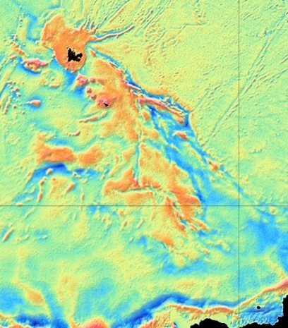
A direct comparison shows that Kerguelen island is rather smaller than Iceland. Adding the surrounding submerged plateau makes it more comparable but still smaller. However, there is much more to the underworld area. Kerguelen forms one end of a much longer, but almost entirely submarine, volcanic plateau, stretching southeastward. The full underwater plateau is shown below (image credit: Australian government). It is over 2000 km long, covers an area of about 1.3 million square kilometres (four times the size of the British Isles, one sixth of Australia) — and it was created by volcanic eruptions. This is a super-Iceland! It consists of three parts, the northern plateau with Kerguelen itself, a central plateau with two small islands (Heard island and McDonald island) and a southern plateau which is fully submerged. Elan Bank, to the side, may also be part of the large plateau. Further south, a trough separates it from Antarctica.
 All together, the volcanic plateau is the largest one in the Indian Ocean, and larger even than the Deccan traps! The size qualifies it as a large igneous province (LIP): by definition, this is an eruption covering an area more than 100,000 square kilometres. Eruptions this size are often attributed to hot plumes melting the lithosphere below the eruption site. The head of such a plume can extend over 1000 km. The ‘Kerguelen mantle plume’ is a plume of legend. Kerguelen island is a harbinger of past doom. For all its remote inconspicuousness, this frozen island with its submarine plateau once changed the world. Australia is still living with the consequences.
Source: Irina Borissova et al. 2003, Geological framework of the Kerguelen Plateau and adjacent ocean basins, https://www.researchgate.net/publication/313158291_Geological_framework_of_the_Kerguelen_Plateau_and_adjacent_ocean_basins
Kerguelen Island and the surrounding northern plateau are volcanically dormant or dead. So is the southern plateau. But the central area still has life in it. Both Heard Island and McDonald Island are active. They are in fact the only active volcanoes owned by Australia (a gift from the UK).
The islands
Heard island is 2800 meters tall (it has grown a bit since wikipedia) making it the tallest Australian mountain outside of Antarctica. You would be lucky to see it though: cloud cover can seem near perpetual. On a rare good day, the mountain shows a shape which is a bit like El Teide, with a pyramid cone sitting on a much larger summit. Rather more common is that it is covered in cloud. The island is called Heard Island, the volcano is strangely named ‘Big Ben’ (occupying pretty much all of the island), and the erupting cone is Mawson Peak. It is among the most frequently active volcanoes in the world, probably erupting a lava flow every few months. The most recent one was 25 May 2023, noticed by no one but captured by the Sentinel satellite.
The island experienced devastating seal hunting in the 19th century. As one document describes: “The plain (Atlas Cove) was strewn with bones of the Sea Elephant and Sea Leopard, those of the former being most abundant. There were remains of thousands of skeletons, and I gathered a good many tusks of old-males. The bones lay in curved lines, looking like tide lines, on either side of the plain above the beaches, marking the rookeries of old times and tracks of slaughter of the sealers.” That was the past. Nowadays Heard Island seems little touched by humanity, being uninhabitable and inaccessible. Even the ubiquitous rats are absent, leaving the sea birds to nest in peace (apart from the regular volcanic eruptions, or course). There are also no introduced plants. Apparently an attempt was made to introduce sheep during the Australian National Antarctic Research Expedition from 1947 to 1954 (Australians don’t feel at home without them, apparently) but they did not survive. Sledging dogs were also brought in and did well but served no useful purpose so they were taken to Antarctica. This leaves a recovering but authentic subantarctic ecosystem. The eastern spit is apparently very popular with elephant seals. Leopard seals are still found here in winter (beware) and the 2 million macaroni penguins are as smelly as you can imagine.
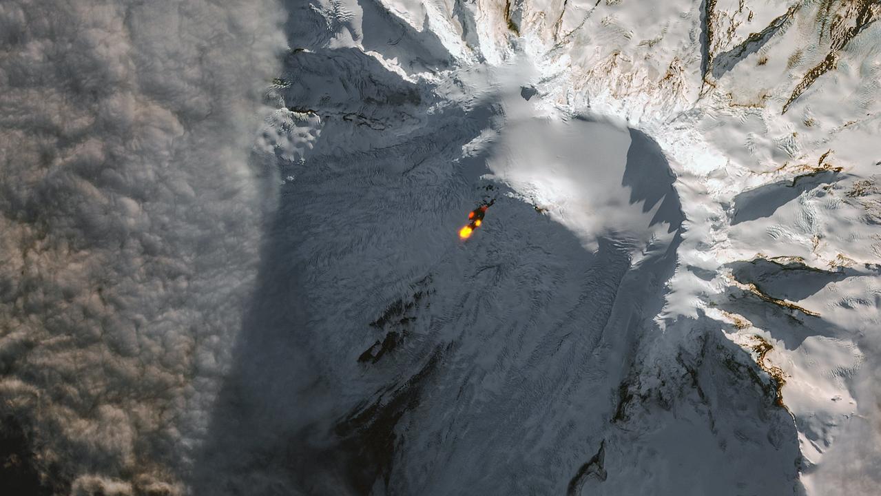
Sentinel image of an eruption at Mawson Peak, Big Ben on Heard Island, on 25 May 2023
McDonald Island with Myers Rock and Flat Island on the left (https://www.farvoyager.com/siov/mcdonald.html)
nearby Flat island ( a descriptive name if ever there was one) has become incorporated in it.

Kerguelen Island. Source: https://earthobservatory.nasa.gov/images/89328/kerguelen-islands
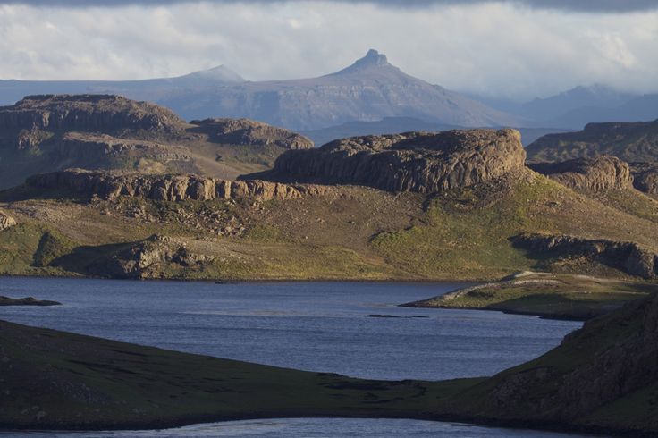
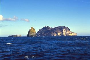
Kerguelen Island is very different from these two volcanic islands. It is much larger, at 150 km across. A description of the island can be found here. The picture at the top of this post shows a scene from the island. The coast is deeply indented with bays; the land is mountainous, rising to almost 2 km. The island shows multiple horizontal layers of basaltic lava, forming a plateau which covers much of the interior of the island. It is deeply eroded and covered by a tundra vegetation. A bonus to people is the presence of edible plants, in particular a local cabbage which provides vitamin-C. The climate is like Iceland’s north coast. Around 4000 reindeer are present, showing the influence of people. So do the wild cats and rabbits! In spite of its isolation, this land is a certified part of the human ecosphere. The reindeer were originally brought to a nearby island by Norwegian whalers (Norwegians don’t feel at home without them, apparently), but they (the reindeer, not the Norwegians) swam their way to Kerguelen freedom. They are the only remaining southern-hemisphere reindeer, after the population at South Georgia was removed. The rabbits came from South Africa in the 19th century and were meant to provide food to the whalers. They are now a major problem especially in the eastern part of Kerguelen. Sheep were a 20th century addition. The survival of feral cats in this tundra world came as a surprise. They descended from cats kept on ships who managed to get to land (probably with human help as they are not noted for swimming). The cats managed to live on rabbits and sea birds.
After the whalers and the sealers had left, an itineracy of scientists came. There are now some 100 people here, living mainly in one town and each staying for a limited time. Tourism is next to non-existent.

Basaltic layers. Source: https://www.tripadvisor.co.uk/Tourism-g1207797-Iles_Kerguelen-Vacations.html
In addition to the central basaltic plateau, close to the coast are several younger volcanic complexes. In the southwest is a series of ring dykes, emplaced underground but visible now because of erosion. They are as young as 5 million years. In the same region are remnants of explosive volcanism: a large caldera and pyroclastic deposits. These may be only 1 million years old and include the last major explosion on Kerguelen. Ross volcano in the south similarly is 1-2 million years old. All these volcanic complexes are extinct. But the inaccessible southwestern peninsula still shows active fumaroles as well as hot water basins reaching 80C. It would be a popular place to visit, had it not been so unapproachable that helicopters are needed for a visit. The suggestion has been made that a hydrothermal system is located underneath the icecap. The heat cannot easily escape from there, and so instead the hot water below the ice feeds the activity beyond the edges of the glacier.
The hydrothermal activity may provide a clue as to why Kerguelen Island is an island. Why is it the only part of the submerged plateau where a large block has been pushed up to above sea level? Other than this, the only islands here are active volcanoes, build up by young lava. To get the old crust to rise up requires a buoyant force below. There must be a heat source below the crust which has lowered the density and thus pushed up the land. The fact that the rest of the plateau is submerged suggests there is less or no heat elsewhere: the warmth is located only underneath Kerguelen Island and nowhere else. But it is currently too weak to produce eruptible magma. The explosive activity a million years ago may have been the last straw of a cooling magma.
At one time, coal mining was attempted at Kerguelen. The very attempt shows there is much more to Kerguelen than volcanics. Coal takes a long time to form: for Kerguelen to have coal, it must be old, far older than a volcanic island should be. This is no Hawai’i, not even a Hawai’i in decline: it has a much more ancient history. (Update: The fossil wood is found sandwiched below the upper basaltic layer and the basement, and was noted already in the early 1800’s during a visit to the northern shores of Kerguelen Island. See below for a description from Geology Today, 2012, Falcon-Lang)

That long history is true for the rest of the underwater plateau as well. Drilling has discovered fossil wood and charcoal in the central and southern plateaus. It shows that at times, part of the plateau, now 2 km deep, was above water and was covered in forests. At that time the plateau was an island the size of Great Britain.
Clearly this is no ordinary ocean floor! Indeed, the Kerguelen plateau is considered a micro-continent, but one that has fallen on hard times and is keeping its head above water only with great difficulty and some help from below. But you can never stop being a continent, even when submerged by 2 km. Continents are the world’s great gift: they are forever.

Reindeer of the south. Source: http://ultima0thule.blogspot.com/2013/03/kerguelen-remote-but-magnificent-sub.html
If this is a micro-continent, where did it come from? They are normally offspring of a bigger continent. We can see the process in Africa: a rift forms, which splits a continent in two quite unequal parts. The African Rift is currently working on dislodging Somalia and sending it into the Indian Ocean. That would create a microcontinent. The Seychelles are a microcontinent which split from India. Micro-continents are geological cast-offs caused by off-centre rifting. But Kerguelen is surrounded by four different continents: Africa, Antarctica, Asia and Australia, in their battle for alphabetical supremacy. So which one is the parent?
And is all of Kerguelen a micro-continent? We have previously seen that the Seychelles are a combination of a micro-continent and a volcanic addition: part has continental crust underneath, but another part is build on oceanic crust. It turns out, this is true for Kerguelen as well. It was not easy to determine. The whole area is covered in kilometers of basalt which gives little clue to what lies beneath. Seismic studies have shown that in the crust underlying the southern plateau, earthquake waves travel at seismic velocities which are typical for continental crust. But in the north, underneath Kerguelen itself, that layer is not seen and here the crust appears to be oceanic. It therefore appears that the microcontinent is the southern part and that the north is a later addition without any continental affinity. The main area that sticks out from the sea is therefore oceanic, and the deepest submerged parts are continental!

Source: http://www-odp.tamu.edu/publications/183_IR/chap_01/c1_1.htm
The continental part of Kerguelen had volcanism in two phases: between 110 and 120 million years ago in the southern part and between 90 and 100 million years ago in the central part. The oceanic extension in the north is much younger. Kerguelen island itself is 25-30 million years old, with a minor volcanic resurgence 10 million years ago which over time migrated south to Heard Island. The gaps in time are so large that the various phases of volcanism probably have different origins. This does not look like a very long-lived hot spot which miraculously stayed underneath Kerguelen, moving with the ocean floor the whole time. Were there several mantle plumes impacting Kerguelen at different times? Or was it something else?
The answers to these are found elsewhere. We need to look around the Indian Ocean.
The Indian Ocean
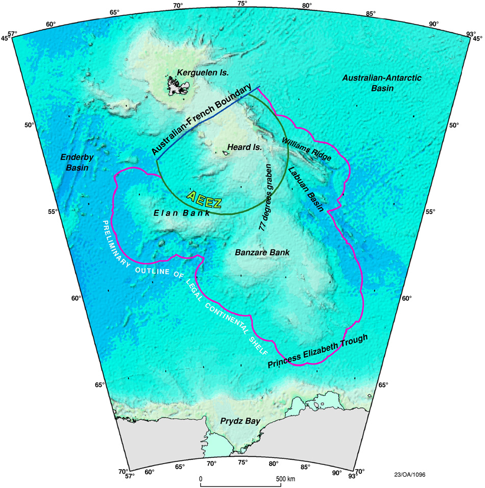
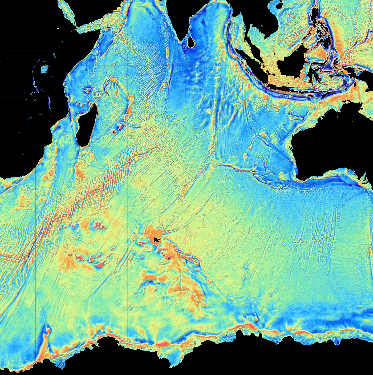
The map below shows the location of Kerguelen in the Indian Ocean (click to see full detail). It is not the only feature in the ocean. Spreading ridges separate the main plates. Faintly visible is the SouthEast Indian Ridge, the ocean spreading centre between Kerguelen and Australia (the transform faults are better visible than the spreading ridge). Much clearer is the spreading ridge towards Africa. A straight line extending almost to Myanmar is called the Ninety East Ridge and looks very much like a hotspot trail. It points directly at central Kerguelen. To the right of its southern end is the Broken Ridge. Broken Ridge is a missing sliver of the central Kerguelen Plateau, separated from it by virtue of becoming stuck on the wrong plate. A spreading ridge is located midway between the two – microcontinents can apparently split and produce nanocontinents. To quote Jonathan Swift,
Naturalists observe, a flea
Has smaller fleas that on him prey,
And these have smaller yet to bite ’em,
And so proceed, ad infinitum
And so supercontinents form continents which shed microcontinents and those split off nano-continents. The smallest, too small to survive, perhaps become the in-continents.

Source: wikivoyage
The ages confirm that this all this oceanic debris is linked. The Broken Ridge is dated to 95 million years ago, whilst the Ninety East Ridge ranges from 83 million years at its northern end to 37 million years in the south. Further afield, fossil dykes and lava flows in India, at the Bay of Bengal, are 115 million years old. So are fossil dykes in Antarctica, on the far side of Kerguelen.

Higher resolution map of our youngest ocean. Click on the map for full resolution. (Source: National Geographic).
Origins
Let’s first match up the younger volcanics. The tip of the Ninety East Ridge nearest to Kerguelen Island has the same age as the Island. The spreading ridge is midway between them. Clearly, Kerguelen Island belongs to Ninety East Ridge. It is the youngest part of this ridge, and came from a lava flood which occured on or near the spreading ridge. Kerguelen Island really did form like Iceland. The rest of Ninety East Ridge formed earlier, over the 50 million period before this event. It came from the same hot spot and was carried away by the moving Indian ocean plate. The Ninety East Ridge is one-sided, showing that the hot spot was not on the spreading ridge for that time, but was located on the Indian Ocean plate. It ended up on the spreading centre only during the final lava flood when it also jumped to the other plate. The spreading centre that had been further south shifted northward, to the hot spot, and separated it from its tail.
The hot spot did not end its existence with the formation of Kerguelen Island. It had lost much of its vigour, but it remained on the spreading ridge. There are two other volcanic islands at its current position. These are the islands of Amsterdam and St Paul, with a series of nearby submarine volcanoes which are strangely named Chains of the Dead Poets. (Indeed, they carry the names of dead poets.) These two islands are at the very centre of the Indian Ocean, at the central point between Antarctica, Australia and Madagascar. It is a telling location.
We need to go back further in time to even deader poets. The older Kerguelen volcanics comes in two groups, at 95 and at 115 million years old. The group at around 95 million years old shows up only in central Kerguelen and in Broken Ridge. These were clearly a single entity at the time. The separation from the spreading ridge is similar to or just a tad more than that of the Ninety East Ridge. This shows that the separation occurred at about the time of the younger volcanics (37 million years ago) or perhaps a few million years before, a long time after the eruptions here had ended. This was the time the spreading ridge jumped northward, and it cut right along the edge of the (probably already submerged) central Kerguelen plateau. A small bit of the plateau found itself on the wrong side, started to be carried away and became the Broken Ridge – an appropriate name.
The spreading centre itself was much older. Nowadays it is located between Australia and Antarctica. The spreading began in earnest 85 million years ago, as indicated by the oldest ages seen at the furthest side of the Ninety East Ridge. What had happened between 85 and 37 million years ago? The long line of the Ninety East Ridge shows that the ocean floor was moving north. This was the same time that India was crossing the ocean and eventually slammed into Asia; the ocean floor around Ninety East Ridge was moving with India. From the length of the Ninety East Ridge and its age spread, the speed of the plate was around 10 cm/yr. The formation of the Ninety East Ridge continued for all this time, until it culminated 37 million years ago with the formation of the northern Kerguelen plateau. This was the time when India had collided with Asia, eradicating the subduction zone between them. This stopped the pull on the oceanic plate, and the spreading ridge slowed down markedly. Perhaps this is why the northern plateau grew so large: for a while, the plate remained near stationary above the magma producing area.
Is the hot spot that formed the central Kerguelen plateau 95 million years ago the same one that formed the Ninety East Ridge? It seems so. The plateau is attached to Antarctica and this continent is very reluctant to move. The plateau has perhaps drifted a bit south-southeast but did not go far. The spreading centre was located such that during much of this time the Kerguelen central plateau was on one side (Antarctica) but the nearby hot spot trail was on the other side.
Interestingly, there were other changes happening 85 million years ago. This is the time when Australia began to separate from Antarctica. Did this separation start with the arrival on the surface of the hot spot that formed the central Kerguelen plateau? Or are we too far from Australia for this?
We need to make another step back in time. The earlier burst of volcanic eruptions occurred 115 million years ago. This formed the southern Kerguelen plateau. The same event is also seen in dykes in nearby Antarctica which formed at the same time. The Rajmahal traps in north east India and Bangladesh also formed at the same time. All these areas were closely connected 115 million years ago. India, of course, at this time was part of eastern Gondwana, sitting between Africa and Antarctica. The current long-distance relations came from the rifting of this part of Gondwana.
But this was still not the beginning. 150 million years ago, this was the heart of eastern Gondwana, when Australia, Antarctica and India were all connected and Africa was beginning to separate. To the north of eastern Gondwana was the Tethys ocean; beyond that, Asia was beginning to take shape. Of course India, Bangladesh and the Himalayan countries weren’t there yet. They were still part of Gondwana, migrants still waiting for the chance to make the crossing.

They waited 15 million more years, while the Jurassic gave away to the Cretaceous and far away the Atlantic Ocean began to form. A minor extinction event, called the Tithonian extinction, heralded the incoming Cretaceous. It is named after a prince of Troy, another lost world. The cause of this extinction is not known. But the world was being redrawn and a new age dawned. 135 million years ago, a flood basalt burst out in what is now southwestern Australia. The remnants are seen in Bunbury, but also very far away in southeastern Tibet. Obviously, these two places were in the same location at the time, in the heart of eastern Gondwana and far from any ocean. India was larger than it is now: some of its area would later be lost in the collision with Asia. The Bunbury basalt erupted where southwest Australia joined with northern Greater India. It was the beginning of the end: eastern Gondwana was beginning to break up in its very heartland.

Source: Rajesh K. Srivastava, 2019
The eruption subsided but it was too late for the continent: Gondwana had broken. But 20 million years lava flows restarted in what is now the southern Kerguelen platform, at the time south or west (500 or 1000 km away?) of Bunbury. And 20 million years after that, the eruption deja vu’d again in what is now the central Kerguelen platform. All three events are often considered part of the Kerguelen flood basalt, but they can also be seen as three separate, unconnected eruptions. A comparison in our own world is provided by the African rift, which started with a flood basalt 30 million years ago and has migrated over that time thousands of kilometers southward. There is now a hot region below eastern Africa, but is this the same hot spot of 30 million years ago? And is elevated Zimbabwe the same hot spot or a different one? Do hot spots perhaps come in families and generations?
The three Gondwana eruptions first caused a rift between Australia and Greater India, and later between India and Antarctica and between Australia and Antarctica. It started with a triple point where the three different branches cut the links between three continents. A slight jump of the rifts separated the southern and central Kerguelen platform from their continents. The question which continent they came from is difficult to answer as the three were one. Based on age and location, one can argue that Kerguelen is a lost piece of Antarctica, but India could also put in a reasonable claim. The Broken Ridge still forms a line that points towards Bunbury, showing that although Kerguelen/Broken Ridge were not part of current Australia, they were on the rift that extended from it.
After the end, the hot spot remained active but it was now under a fast moving plate which caused it to form a long, straight trail of volcanoes: the Ninety East Ridge. India was moving north, crossing the Tethys ocean and carrying parts of the first two flood basalts with it. One ended up near Lhasa and one near Bangladesh – their separation shows those two events occurred at least 500 km apart – possibly much more because of the compression of India. Over 20 million years, that amounts to only a few centimeters per year, so it may be that it was not the volcanics that was moving, but the newly created plates.
Finally, 37 million years ago, when India had collided with Asia, the Kerguelen region again erupted in flames. Was this a new flood or was it just because the plate had stopped moving? At the same time, Australia accelerated in its northward motion – there was a re-organisation off the subduction zones in the Indian and Pacific Oceans (still connected at the time). The fire created a new extension to Kerguelen, but this time build on oceanic crust. After that, Kerguelen found itself moving away from the speading ridge and the volcanics subsided. Did the collision of India affect the magma supply here, far in the Indian Ocean? Perhaps the hot spot had long gone, and the volcanics came from a crustal weakness together with the spreading, allowing mantle material to reach for the surface. Or perhaps there still is residual heat here dating back to Gondwana. Either way, some volcanics continued at the spreading ridge.
There was one more chapter to the story: why did Kerguelen island remain above, or re-emerge from, the sea? Once it left the hot spot behind, it would have sunk below the waves. There was another volcanic episode 10 million years ago, at a time when it was already far from the spreading ridge. Weak activity continued afterwards. It is not clear where that re-activation came from – a sideways convection current from the spreading ridge, perhaps, stopped by the thick crust of the Kerguelen plateau? Or was it related to the beginning of the collision between Australia and Southeast Asia, east of the Wallace line? That seems more likely: the subduction pattern again changed, the pull on the Indian Ocean changed and this reactivated the weakness still present near the edge of the Kerguelen plateau. The map shows a trough. Stress does not like edges.
And that is the story of Kerguelen. It holds memories of a very different world when the southern hemisphere was united. Eastern Gondwana broke down because of massive eruptions which happened over tens of millions of years. The rifting gave us the Indian ocean – but it also left us debris all over the ocean. Kerguelen has drifted away from the original centre of the action – that is now at Amsterdam/St Paul. A little volcanic activity is still continuing but it is no longer attached to the hot spot to which it gave its name. The world has moved on. But we should look at Kerguelen, and remember. It is an elegy written in lava. Gondwana, in memoriam.
Albert, August 2023

‘So you are from Gondwana too?’
Reading:
http://ultima0thule.blogspot.com/2013/03/kerguelen-remote-but-magnificent-sub.html
Paul J. Wallace et al: Origin and Evolution of the Kerguelen Plateau, Broken Ridge and Kerguelen Archipelago: Editorial, Journal of Petrology, Volume 43, Issue 7, July 2002, Pages 1105–1108
Regis Ballestracci, Jacques Nougier:
Detection by infrared thermography and modelling of an icecapped geothermal system in Kerguelen archipelago, Journal of Volcanology and Geothermal Research, Volume 20, Issues 1–2, 1984, Pages 85-99
1. Leg 183 Summary: Kerguelen Plateau-Broken Ridge—A Large Igneous Province: http://www-odp.tamu.edu/publications/183_IR/chap_01/c1_1.htm
Sheng-Sheng Chen and others: The Tethyan Himalaya Igneous Province: Early Melting Products of the Kerguelen Mantle Plume, Journal of Petrology, Volume 62, Issue 11, November 2021
Francine Bénard, Jean-Paul Callot, Roland Vially, Julien Schmitz, Walter Roest, Martin Patriat, Benoît Loubrieu:
The Kerguelen plateau: Records from a long-living/composite microcontinent,
Marine and Petroleum Geology, Volume 27, 2010, Pages 633-649
Rajesh K. Srivastava: Early Cretaceous alkaline/ultra-alkaline silicate and carbonatite magmatism in the Indian Shield – a review: implications for a possible remnant of the Greater Kerguelen Large Igneous Province, Episodes, Volume 43 (2020), Pages 300-311 (https://doi.org/10.18814/epiiugs/2020/020017)


“Paleontologists often stress the incompleteness of the fossil record. Geologists have known since the late 19th century that the world’s fossil-bearing rocks represent a discontinuous fraction of the various environments that have come and gone through time. Places like dune-filled deserts, floodplains and sea bottoms where sediment accumulated are preserved, but mountains and other environments have eroded away and been erased from the record.
And even within those ancient environments, most life-forms never made it into the fossil record. They were either consumed, decayed or otherwise broken down. The vast majority of organisms that have lived on the planet didn’t stand a chance of becoming fossils.”
(quote) link:
https://www.smithsonianmag.com/science-nature/how-many-dinosaurs-remain-undiscovered-180982560/
Good to know: “Paul Renne of the Berkeley Geochronology Center has reported that the date of the asteroid event is 66,038,000 years ago, plus or minus 11,000 years, based on Ar-Ar dating. He further posits that the mass extinction of dinosaurs occurred within 33,000 years of this date.”
https://en.wikipedia.org/wiki/Alvarez_hypothesis
Hypothesis btw. Endorsed by a majority and by Iridium found in many sites on Earth.
But up to now the rule was always that in Paleontology nothing was ever known for good. Interesting field, but tedious.
So, they didn’t die right away. Some of them did, like the ones dicovered in Hell’s Creek. Many of them belong to one group/family. 14.000 species have been discovered so far. The estimate of all species varies between the Hundredthousands and Millions.
Luis Alvarez was a great physicist I guess. He was on “The Great Artiste”: This moving letter to his son to be read later in life should be known:
https://history.iowa.gov/history/education/educator-resources/primary-source-sets/world-war-ii/letter-dr-luis-alvarez-to-his
Similarity:
“Last but not least, Morocco is located at a triple junction (Fig. 1.1) between a continent (Africa), an ocean (the Atlantic)
and an active plate collision zone (the Alpine belt system).”
https://www.researchgate.net/publication/234438988_Continental_Evolution_The_Geology_of_Morocco
“Central southern Turkey and northwestern Syria are affected by the interaction between three tectonic plates; the African Plate, Arabian Plate and Anatolian Plate.”
https://en.wikipedia.org/wiki/2023_Turkey%E2%80%93Syria_earthquake
For some reasons the authors of the link above leave out the Trans-Saharan Seaway:
https://www.sciencedirect.com/science/article/abs/pii/S0195667115300732
According to Wikipedia the North Sea had a dome during Jurassic Age. Was it a hot spot that fueled the rifting of North Sea that continued through Cretaceous period?
The small North Sea looks like a micro sister of the Atlantic Ocean. Rifting, sea floor spreading, volcanism created the sea where previously were the Caledonian and Variscan mountain chains. Otherwise the landscape from Scandinavia would still run through Scotland and Ireland without interruption.
Between 34 to 28 MA, imagined:
Earlier even higher water levels, more islands.
About 10.000 years ago, glaciation, low water levels, therefore landbridge:
Mammouth fossils on the channel floor, taken down when the ice burst.
https://upload.wikimedia.org/wikipedia/commons/7/7e/Doggerland.svg
No rifting on ocean floor, always shallow sea with alternating sea levels and connections to other seas. Nothing similar to the Atlantic Ocean. No ocean in fact.
That same wikipedia. ???
North Sea article: https://en.wikipedia.org/wiki/Geology_of_the_North_Sea
Jurassic age was 200 Million to 145 Million years ago. Rifting already began during early Triassic era, but accelerated afterwards.
Seems to be a mini swarm ongoing on the Reykjanes Peninsula after the 3.8 at Krýsuvík, focussed on Krýsuvík, Keilir and Fagradalsfjall. Mini in size of quake and number.
https://en.vedur.is/earthquakes-and-volcanism/earthquakes/reykjanespeninsula/#view=map
Since Chicxulub made a crater cavity 188 km wide and 30 km deep at moment of impact .. is it correct to assume that around 220 000 km3 of materials was vaporized and ejected and sent on ballistic reentering trajectories?
If that volume is correct it makes it very easy for me to understand what a catastrophic event it was and is in many ways the most horrible mass extinction since complex life began. With that volume ejected its easy to understand that most of the planet probaly burned, it also was an instant event unlike Siberian Traps
Seems indeed strange that Neoaves survived and Paleognathae birds also surivived
“Proto-Caribbean Seaway”
Your asteroid and the bore hole the beast created existed, calm down. The question is where
“Divergence between the North American and South American Plates began to create oceanic crust off Colombia’s Pacific coast by the end of the Jurassic (150 Ma). This divergence, which continued until at least 66 Ma, first resulted in a “proto-Caribbean spreading ridge” between these plates flanked by a perpendicular transform zone on its Pacific side. By 135–130 Ma, the subduction of the Farallon Plate had begun along this transform zone, effectively modifying it into a subduction zone and beginning the creation of the Great Caribbean Arch. This arch was formed around 120-115 Ma but must have been intersected by the Caribbean spreading ridge until 66 Ma. Hence, the Farallon Plate fed the spreading zone and later became the Caribbean Plate.”
https://en.wikipedia.org/wiki/Caribbean_large_igneous_province
105 Ma, imagination:
Late Cretacious, imagination:
The crater is on the southeastern end of the American plate. So no miracle that the US is a wonderland of Late Cretacious fossils. The other questions are i.e.:
How was the angle?
How deep was the water?
Where was the IP Carribean Plateau (debated)?
Was that volcanism finished?
How far was North America from the MAR?
How many thunderstorms and hurricanes were there afterwards?
and so on
Hell Creek’s fossils died in a flah flood/tsunami. The fishes had still ingested those glass beads that have a certain name – forgot.
The water was around 150 m deep I think so shallow, even If it hit the deep sea pacific thats around half the
asteorids diameter in depth so 5700 m it woud be the same catastrophic results
The water rushing back into the crater after the impact woud be a spectacular sight, as walls of water crash over thousands of degrees hot impact melt setting the stage for a long lived impact geothermal system, Chicxulub after the impact had its own black smokers and the impact generated geothermal heat lasted all way into Paleocenes first stage
Sure with the depth, Jesper?
Phanerozoic sea level, wikipedia. Then keep in mind, it wasn’t there. It travelled with the American Plate. All of Middle America might have been partly under water or not built up yet to a significant height by subduction.
This is the map of North America at the time of impact, most of the western interior seaway was gone though some was still there as you can see. The high sea levels of 80 MYA were fairly short lived, supposedly because the average depth of the ocean was slightly less after the breakup of Pangea, lots of young buoyant crust. Same thing sort of happened in the Cambrian-Ordovician as there was a lot of spreading ridge activity there too, and the sea level fell off after.
That narrow seaway would have been a funnel for the impact waves. Given how the area was only relatively recently exposed land within the past 10 million years at that point, the waves probably did wash very far inland at the north end, hundreds of km seems plausible, I dont know precisely where Hell Creek is on this map but it got that far anyway. I hesitate to say the waves washed all the way to the north end of the continent to meet with the other WIS remnant there but with an event of this magnitude that may have been a possibility. And if it wasnt, probably only because the impact was not in the actual deep part of the gulf just on the edge.
Isn’t it a real wonder that the Americas changed so much between 100 Ma and 65 Ma and since then basically didn`t change at all, at least in the Caribbean?
That bay looked about the same as today while India, Australia, New Zealand, Africa, Wrangellia, the Pacific Plate et alii did some fancy travelling, Europe and China becoming curious and popping their heads out of the murky waters?
This story is more complex, a gift to Paleoontologists and Geologists for years to come feeding them with interesting science.
And isn’t it sort of amazing that Mike took Elugelab out and created a crater of only 1.9 km width and 50 m depth and killed all life around including corals, but Robert de Palma found completely intact bodies of one group of sauropods and completely intact skeletons of fishes who had still fed before the flash flood, proven by spherules in their stomach region?
This story is much more complex. I don’t even know whether Alvarez only decribed the crater rim and the Iridium he found or whether he also created the scenario. If yes his vision might have been blurred by the profound shock of watching Hiroshima. The crater rim is real, the Iridium is real, the tsunamis and flashfloods are real. There must have been much more lightning than after the test of Mike, so also wild fires, and there must have been radiation leading to sterility of the survivors plus shortage of food.
What is not at all clear is the time frame and the location of the North-American Plate at the time. What seems to be clear is that the dinosaurs, if they came back, couldn’t live here due to the low pressure. There time was over, due to climate change. It probably took several tens of thousands of years and had been prepared by changes in the oceans.
Then, besides a comparison to Mike, a comparison to HTHH is an invitation as well, the relatiively small tsunami travelling around the world, the water column going about 50 km up into the Ionosphere. That water column back then must have been gigantic, the tsunami as well.
The only thing one has to do is to move away from Yucatan. As every other continent and country that area was then completely different, the Atlantic Ocean, northern part was at least 50% narrower, the Cordillera wasn’t there in the form we see today, and “Wonder Chicken”, found a few years ago by Cambridge scientists, survived the dinosaurs who would have loved chicken like many of us do.
That cheap horror story which horrifies every child is not like the media make it up. It was a lot more complex, that’s for sure, at least imho. Morocco in that context is interesting as Morocco might not yet have been where it is now.
Btw., more than 2000 dead and more missing in Morocco after earthquake. Africa has broad shoulders. They don’t fit through the door which naturally causes those desasters on both sides.
Hoping that Albert writes s.th. about it being very good in earthquakes.
What do you mean by dinosaurs would not survive in the present day? They literally already do, but even then there were large parts of the Mesozoic with similar climate to most places today, no ice caps at the poles doesnt mean the whole earth was an equatorial hothouse, most of it would still be what we call temperate even if maybe those climate zones were a little higher latitude than present. The poles saw sub zero winters.
If someone did a Jurassic Park and made a T Rex that dscaped, its biggest problem would be actually finding enough to eat not the environment.
Grass. Dinosaurs had to be so large in part because of the need to digest their food. Grass did not exist yet. It takes a lot of time to digest wood, and trees don’t like being eaten. If dinosaurs lived now, they would be smaller and eat more grass. My guess.
Air pressure, Chad. Have the paper saved somewhere.
Besides 😉 we would have shot them all. Different times. Teeth are out of fashion with the exception of those waters of Australia, Hawai’i and South Africa where those sons and daughtes of those maritime survivors are hunting.
Isn’t it somehow beautiful that we didn’t have to shoot them? Not guilty for once.
Air pressure was basically the same as now, maybe tiny differences but nothing that would be important. Much less variable than just going up a mountain. Same for oxygen level, it was high in the Cretaceous but in the Triassic and early Jurassic it was lower than today. Apparently the concentration in the middle Triassic, about 240 MYA, was the lowest point it has ever been since complex life evolved, at 12% at sea level. Breathing at sea level then would be like breathing at 6500 meters elevation, it would be barely survivable but you couldnt make a fire and it is unlikely anything lived more than a few hundred meters up, maybe 1 km at most, which excludes probably almost all of Pangea. Archosaurs probably evolved their unidirectional lungs as a result, and therapsids a diaphram, to allow possibility to breath. This is also when dinosaurs evolved… 🙂
I should add that these numbers are actually for some reason very hard to find and a lot of different numbers exist with very different outcomes. But the majority I found had Mesozoic O2 being more or less the same as now, and very high from the Devonian to middle Permian before plumetting extremely around and just after the P-T then slowly recovering up to the middle Jurassic.
There are different ops. Some think if they suddenly popped up today they would get Caisson Disease.
The composition of their air though can be measured in inclusions in amber.
100 s of meters deep then likley
Dinosaurs ate ferns, leaves and shoots those are easier to digest that grass
Grasslands during Cretaceous where fern praries and angiosperm prarie thats basicaly a lost ecosystem, but there are also fossil edivice of Meozoic grass althrough they did not become dominant until the meozoic
Until the Miocene
Hadrosaurs ate basically everything, their hundreds of tiny sharp teeth and powerful chewing jaw motion would grind any plant matter they ate into pulp. I cant see them having any trouble eating grass when the ones at Hell Creek were eating pine needles, and hadrosaurs were some of the heaviest and biggest dinosaurs so it obviously worked… Sauropods might have not adapted so well to eating grass though, being that they didnt chew, but then that also didnt stop them eating basically anything plant related either.
I guess we will never know. But given how many unrelated mammal lineages managed to independantly evolve to eat grass it seems a very big call to say dinosaurs couldnt have done it.
But they would not have had to be so big. You’d get a minisaurus.
Why would they not be so big? Elephants are more or less the same size range as the majority of hadrosaurs, and eat grass. And the largest terrestrial mammal was an elephant that was very closely related to the modern ones, and ate grass too, and it was as heavy as 30 tons, actually bigger than the biggest hadrosaurs and even most sauropods… Grass is not really poor in nutrients, it is so abundant that factor isnt really important in a healthy ecosystem, its just abrasive so difficult to chew, and none of the mammalian megafauna have continuously growing teeth. But hadrosaurs did, so wearing them out was less of an inconvenience. And the way they chewed was through horizontal flexing of the lower jaw halves away from each other at the same time not a rotating movement of the whole lower jaw like seen in cows, so a much more efficient way.
Elephants eat trees. Trust me – I have seen them do it.
They eat all plants and it varies but they can eat only grass. And wooly mammoths, which were only a bit smaller, those only ate grass, no trees out on the mammoth steppe. Point is that eating grass doesnt make animals smaller. Animals get taller to eat from trees, and some did so by just getting physically gigabtic so their heads were up there, others strstched a body part usually the neck, some just stand up. Some (giant sauropods) did all three… 🙂
Elephants eat trees. Theu don;t do well on grass.
But grass was there, contrary to what was thought 20 y ago:
“Before 2005, fossil findings indicated that grasses evolved around 55 million years ago. Finds of grass-like phytoliths in Cretaceous dinosaur coprolites from the latest Cretaceous (Maastrichtian) aged Lameta Formation of India have pushed this date back to 66 million years ago. In 2011, fossils from the same deposit were found to belong to the modern rice tribe Oryzeae, suggesting substantial diversification of major lineages by this time.”
Ref. 18-20. wikipedia, Poaceae
Alternatively the coprolites are wrongly dated. So this is a movable feast. You have this date, 66 million, before it was 65 million btw, then 65-66 million, so the coprolites must be 66 million years old. 10-15 years ago they were probably 65 million years old.
Either the grass appeared in the Tertiary/Paleogene and some of the animals were still around – my guess – or the grass appeared already in the Cretacious.
They were omnivores, the maet-eating ones.
Grass was there. In Asia. Burmese amber. Nothing about North America.
Grass became widespread during the tertiary cooling, as global temperatures dropped and rainfall and humidity dropped as well and only in middle to late miocene had modern grasslands evolved they also thrived in a lower cO2 enviroment that trees did not
Cretaceous Earth was very much a forest planet I guess and lots of clouds and rainfall from high humidity sourced from warm oceans, so grass where probaly at perpery at river banks
If it pops up
Good graphics over the impact .. ( height not to scale with crater width I think )
Anyway west Europe and Mediterranean have a very very complicated active geological history indeed through the mesozoic its been geological chaos, not a stable craton in anyway, lots of rifts, subduction plates and collisional belts
Its only tertiary that Europe began to become more stable even If volcanism and rifting is still ongoing in Germany, France and even parts in Romania, the young crust and turbulent past probaly explains why central and western Europe and Mediterranean have souch very high geothermal gradient. During Jurassic and Cretaceous it was a mess
Wow only 12% at sealevel. And If atmosphere was much denser in an alternative Earth Imaginary scenario in nitrogen it woud make that much more breathable for modern humans as o2 woud have a higher pressure too
21% o2 is breathable all way up to 6 Earth atmospheres without toxicity, a denser exoplanet atmosphere haves all kinds of advantages for planetary habitability than just 1 bar. With more atmospheres Earth coud just orbit further out to balance its increased greenhouse effect, denser air also evens out Pole and Equator temperatures gradients too.
If any exoplanets are habitable at all, most of them will have more nitrogen pressure than Earth have today. Thinner -aired worlds like Earth can have wide sterile belts–desert zones and polar caps. Pole – Equal Temperature gradients are much even on thick-aired worlds and less cO2 is needed too to keep the planet warm. Venus’s poles and equator may be hot, but they’re equally warm, unlike the Terran/Martian patttern. Alien life competing in a stable environment’s more likely to turn multicellular (and intelligent) than life struggling mainly against a marginal, desertic Martian landscape. The thick o2 pressure of more nitrogen atmosphere pressure will also supercharge muscles and organs at creatures and even more fuel to fuel evolution or complex life even If oxygen is lower than Earths, alien creatures dont need as much red blood cells either
Thick-aired exoplanets, with their stronger greenhouse effect, can orbit further out, where the zone in which water is liquid (and life can evolve) is much wider. This may not automatically increase the number of such worlds–the match between atmosphere and orbit is still a matter of chance–but rigid formulas declaring outer solar systems totally sterile are just plain wrong. Small red stars, for example, have been written off, since their liquid-water zone was so close that tidal drag becomes a problem. But thick-aired worlds could orbit further out with their bonus greenhouse effects, where they run no risk of ending up with one face always to the sun
Many superhabitable thick aired Super Earths are probaly jungle – archipelago planets with a thick rich atmosphere bathed in the light of golden K dwarf sun, large oceans are also an advantage to suck up extra cO2 from lively volcanism
You would need a brighter K-F type star to allow photosynthesis though, a planet orbiting far enough from a red dwarf to not get locked would be very dark, not pitch black but like twilight and with very little energy. The atmosphere would probably need to be so thick to keep the planets own heat in and a positive temperature that it would be crushing. Life there would be nothing like anything on earth, like stuff on the abyssal seafloor but in air still, and not dark.
Really, such a planet might as well be a rogue planet, its surface temperature is based on its own heat output mostly, not the star.
I have wondered, if in the distant future we could swap Venus and Mars… at that distance Venus would cool down and all the acid clouds would condense out, maybe making lakes of H2SO4 in some low spots. Still a thick CO2 atmosphere but now no longer 400+C so more manageable. Mars might temporarily thaw out, probably would not stay habitable but for a few million years another second home, just add oxygen and good to go. Of course moving a planet is way harder than just trying to terraform Mars as it is now but Venus is larger and could hold an atmosphere, moving it to a higher orbit would give us way more potential as another Earth.
K dwarf is best .. in middle habitable zone with a thick atmosphere
K Dwarfs are seen as ”superhabitable stars” sunlike althrough lives longer than the sun will
Reminder:
natural selection will provide the metabolism to suit the environment. Given an appropriate structure that permits natural selection any energy source in any environment can power life.
Personally I would like to examine the clouds of jupiter. A simple balloon would do if only you didn’t burn up before reaching the cloud tops.
Jupiter has rather nice annual colour changes too (jupiter year).
A very slow metabolic system may even be possible in places like Titan. Its certainly got complex hydrocarbons.
I too have always wanted a Jupiter balloon probe ( warm hydrogen )
With a camera as well woud be magnificent to see the blue hydrogen dayskies and the cloud tops and knowing there is No surface below that which is kind of disturbing
The atmospheric entry at Jupiter is the hardest part even at the equator and entry speed along rotation you go in at 50 km a second and haves to endure 16 000 c
Elsewhere entry speeds are even higher 60 km a second or more depending on angle
Superhabitable Super Earth Alien planets? Yes maybe
A Rocky Planet somewhat larger than Earth coud be ideal for life, If it orbits a somewhat smaller sun that lives longer. ( 3 Earth masses and a K class orange dwarf sun )
Gravity wont be crushing either..
3 Earth masses gives almost No diffrence in gravity. You needs 10 Earth masses for 2X Earth gravity.
So large Super Earths will haves a supprisingly earthlike gravity.
A somewhat larger planet will be ideal for keeping Plate Tectonics active, beacuse of a hotter interior than Earths, The interior retains more heat from formation, and more radioactive decay in a larger planet. Plate Tectonics is crucial in recycling Carbon Dioxide and Minerals. On somewhat larger Super Earths 2 to 3 Earth masses .. Tectonics maybe very lively with a thinner litosphere under more stress. Moderate sized Super Earths may have very fast tectonics indeed, forming an oceanic planet with a chaos of microcontinents, and mountain ranges and volcanoes everywhere. Icelands and New Zeelands everywhere on souch planet. Chaos Tectonics maybe in Big oceans
Tectonics is crucial for keeping the CO2 levels so biosphere can photosyntesis and breathe.
On Super Earths plenty of volcanic outgassing and as well as fast subduction may keep the CO2 more steady than Earths and avoid snowball events and climate disasters. Plate Tectonics is the planets CO2 thermostat.
Moderatly sized Super Earth class planets maybe ideal at this recycling with their larger mass.
Our Super Earth will also have a very powerful magnetic field, with core temperatures of over 11 000 C the entire core maybe liquid, and combined with the large planets fast spinn, You will have a very very powerful magnetic field.
Thats very useful protection when orbiting orange dwarf stars that can flare often. Souch a magnetic field coud be much stronger than Earths. The core will be liquid for much longer than Earths too due to the planets greater mass.
A somewhat denser atmosphere than Earths will also be very useful on these planets. Denser Atmosphere allows you to orbit further out in the habitable zone, denser atmosphere also evens out the temperatures, keeping the poles warmer and as well as helping the winters to get less severe. With more air pressure You gets supercharged creatures with oxygen and CO2, and needs less in PPM than Earth to keep the climate stable. Denser air also warms on its own, less temperature diffrence between Equator and poles, and poles maybe Ice Free.
There will also be less deserts and more humidity, and rainfall If there is lots of water
A somewhat smaller Star than Earths sun sounds ideal too: it lives longer
So God made a mistake 😉
Next time he’ll do better in some galaxy.
He’s not the first physicist who makes mistakes. In Los Alamos they didn’t know whether Trinity would be a success until they had seen it.
Super Earths are very common around K Dwarfs stars so this coud be a very possible scenario .. the icecaps in the graphic should be removed
A bigger planet with a deeper atmosphere (either or both) will get to the point where no chemical rocket can achieve orbit above the atmosphere. I am guessing earth is quite close to that limit already.
And Hawaii is defentivly my favorite volcanoes and resulted in many visits and I sadely taken home ALOT of rocks from Mauna Loa and from molten lava that I sampled myself by spade from the Puu Oo eruption
Tūtū Pele is huhū loa…. exceedingly angry …
I can feel her curse on me and her darkness and immense power : D D :
https://www.usgs.gov/news/photo-and-video-chronology-kilauea-january-24-2014
https://www.usgs.gov/news/photo-and-video-chronology-kilauea-january-24-2014
Some nice videos showing how fluid Hawaiian lavas is up at Puu Oo .. very liquid stuff
Nice beast here, 60 million years older than the asteroid impact site:
https://www.reuters.com/science/new-dinosaur-found-spain-illuminates-history-meat-eating-group-2023-05-18/
His common ancestors with American creatures must have ended up on the wrong side of the MAR.
In Morocco they have found a relative of the T-Rex recently. Will take some time though to find out when he lived.
When you ggl the first creature you can find some Israel sites saying as a headline sort of: Relative of the dinosaurs who went extint 66 Ma. This one obviously lived long before that period.
Tip: When you ggl the period use 70 Ma or 60 Ma. You get better results instead of the same old story. Better maps as well. The maps for 66 Ma and 65 Ma are now adapted to the impact site found in Yucatan which – miracle – hasn’t changed a bit in 65 million years. Must be glued to the mantle there.
Headline: Widespread elevated iridium in Upper Triassic–Lower Jurassic strata of the Newark Supergroup: implications for use as an extinction marker
“Abstract
Anomalous levels of iridium in sedimentary strata are associated with mass extinction events caused by impact events. In the case of the end-Triassic extinction event, the anomalies as well as the extinctions are linked to the eruption of the Central Atlantic Magmatic Province (CAMP) flood basalts. We report new data on concentrations of iridium in continental strata of the Fundy, Deerfield, Hartford and Newark basins, both above and below the oldest CAMP flows in these basins, that demonstrate that these anomalies are more common than previously known. We conclude that the enrichments were at least in some instances likely derived locally by concentration due to leaching directly from the lavas into sediments proximal to the CAMP flows due to post-eruptive hydrothermal activity. In other instances, the enrichments likely record the global fallout of aerosols and/or ash particles during the eruptions of the CAMP basalts. The common association of the highest levels of enrichment with organic matter suggests either redox control or stabilization by formation of organometallic complexes following post-eruptive redistribution. These findings demonstrate the importance of considering the distribution and magnitude of iridium anomalies in considering the source of the iridium and possible extinction mechanisms.”
https://www.nature.com/articles/s41598-020-76238-4
Rocchia et al.: Iridium in Deccan Traps
Discussion
The negative result reported in this paper unfortunately does not help us in constraining the solution of the debate
between an internal and an external scenario for the KTB events. Although not many flows have been analysed, the
remarkable homogeneity of the results would suggest a unique source for the lavas. Some might say that the lack of
measurable iridium in the Deccan lavas and intertraps argues against any link with the source of the KTB events.
However, should one follow the idea that the Deccan represents the appearence at the surface of the Earth of the
Reunion hotspot (Courtillot et al, 1986; Courtillot and Besse,1987), and accept that most of the Ir originally contained in
the magma escaped in the form of volatile complexes such as fluorides during outgassing of the magma (Olmez et al,
1986), all that can be constrained is the original air concentration of that magma.10 kma for the Deccanbasalts,the
original concentration is found to be on the order of 0.05ng.g-l (or 5.10-•’), i.e. about three times less than the
present Reunion and Hawai hotspots, and generally below the detection threshold in our technique.”
https://hal.science/hal-03551212/document
(a bit old though)
New Clues to Agent of Life’s Worst Extinction
“But no such sharp iridium anomaly has been found in sediments coinciding with any of the other mass extinctions. Moreover, iridium is often found in association with volcanic eruptions, particularly in the Siberian Traps, a region known for its rich ores of platinum-group metals, including iridium. This fact has helped to keep scientific debate bubbling.”
https://www.nytimes.com/1992/12/15/science/new-clues-to-agent-of-life-s-worst-extinction.html
This deserves to stay sceptical. If it was volcanic it was the class of Apolaki:
https://en.wikipedia.org/wiki/Apolaki_Caldera
A bit larger than Toba. Erosion by water has to be taken into account though.
Apolaki: ” Rock samples ages range from 47.9 to 26 million years”…
https://en.wikipedia.org/wiki/Eocene%E2%80%93Oligocene_extinction_event
The competitor is Popigai. Or collaborator.
There are a lot more extinction events than just five, just smaller.
Yes, there is more to the story:
Earth’s Atmosphere Had Terrifying Mercury Pollution Even Before The Killer Asteroid
https://www.sciencealert.com/earth-s-atmosphere-was-polluted-with-mercury-even-before-the-asteroid-that-killed-the-dinosaurs
Brillant piece showing all contradictions. i.e.:
“It was all beautifully simple and intuitively made sense. But it could not account for the ground truth. Too many facts contradicted tsunami deposition for the sandstone complex in NE Mexico, including multiple spherule layers separated by a 20-25 cm thick sandy limestone (unit 1) with j-shaped burrows infilled with spherules. Two ash layers (zeolites) and several horizons of bioturbation (Chondrites, Thalassinoides and Ophiomorpha) within the alternating sand-shale layers of unit 3, all indicating deposition over an extended period of time (exceeding a tsunami event) and marked discreet ash influx and repeated colonization of the sea floor (Adatte et al., 1996; Stinnesbeck et al., 1996, 2001; Keller et al., l997; Ekdale and Stinnesbeck,l998, Fig. 6). Spherule deposition (unit 1) thus occurred in two events separated by a long period of limestone sedimentation, whereas unit 3 was also deposited over an extended time period.”
https://agupubs.onlinelibrary.wiley.com/doi/full/10.1029/2019GL085482
Deserves to be read in toto. Discussion not closed. Open end or never-ending.
Sorry, wrong link:
https://www.geolsoc.org.uk/keller
“The Chicxulub impact was not KT in age. The final evidence came from the Brazos sections in Texas, a shallow water environment, devoid of slumps, that had undergone no significant tectonic disturbance since the late Maastrichtian. The Brazos sections boast one of the highest sedimentation rates in an inner neritic environment of less than 20m depth during the KT transition and cut by incised valleys during the latest Maastrichtian sea-level fall. The high sediment accumulation in this environment preserved stratigraphically well separated records of (1) the original Chicxulub impact spherule ejecta layer (altered to cheto smectite) in late Maastrichtian claystone of zone CF1 about 300,000years before the KTB; (2) three upward-fining impact spherule layers eroded from nearshore areas and redeposited at the base of incised valleys; and (3) the KTB up to 90cm above the sandstone complex that infills the incised valleys (Keller et al., 2007).
Despite all this evidence, the KT controversy rages on. In their recent paper Chicxulub impact proponents redefined the KTB based on impact signals and claimed that the Chicxulub impact is the sole cause for the KT mass extinction (Schulte et al., 2010).”
All this strongly reminds me of the mantle plume debate. Luis Alvarez`’ reproach of incompetence indicates also gender predudice, a known phenomenon in former male fields. Another victim of this is settled in the centre of the Plume debate.
Whether Rosalind Franklin who was “forgotten” by the Nobel Prize Committee for her work on the Double Helix is also a victim is open as she died a long time ago.
Too bad I cannot ask Einstein.
So, both debates will go on which is good and also interesting.
We once had a Foreign Minister who had before being FM exclaimed in Parliament: “With all due respect, Mr. President, you are an asshole!”
Luis Alvarez would have deserved that response, I am not sure about that Parliament’s President back then.
Concerning “incompetence” this is incometent:
“After he completed his oral exams in 1936, Alvarez, now engaged to be married to Geraldine Smithwick, asked his sister (then secretary of Ernest Lawrence) to see if Lawrence had any jobs available at the Radiation Laboratory.” wikipedia, Luis Walter Alvarez
And this is competence:
“In the spring of 1913, two German visitors, Max Planck and Walther Nernst, called upon Einstein in Zürich in the hope of persuading him to relocate to Berlin.” wikipedia, Albert Einstein
Please, dragons take out the agupubs link, was wrong. happens with too many tabs open, sorry.Denaliwat
Interesting recent paper about Katla, with high definition images of the bedrock under Myrdalsjokull.
https://jokull.jorfi.is/wp-content/uploads/2021/12/J71-39-70.pdf
Seems like Katla actually does have an active ring fault, as there is a ring of bumpy elevated terrain just inside the caldera cliff. There is also an area that looks like an elongated crater, maybe an explosion crater from the last few eruptions, or a collapse pit crater or nestled smaller caldera, possibly from the two large eruptions in the 18th century.
Also seems a very plausible case that the current caldera was created by Eldgja, it is still pretty clean and defined, without a lot of infill, despite Katla being one of the more active volcanoes in Iceland. The caldera might have been there before but as a shallow ring fault structure not as a deep pit we see today.
New post is up. Earthquake in Marrakesh
https://www.volcanocafe.org/the-morocco-marrakesh-earthquake/
Come on Chad. Albert tells you he has seen elefants feed on trees and you say they only need grass:
“Tree bark is a favorite food source for elephants. It contains calcium and roughage, which aids digestion. Tusks are used to carve into the trunk and tear off strips of bark.”
https://seaworld.org/animals/all-about/elephants/diet/
Also deer feed on trees:
https://www.woodlandtrust.org.uk/blog/2019/05/what-deer-eat/
Patagotitan maiorum and his relatives might have had a reason do develop a long neck (or the bigger ones survived first, selection of the fittest):
Araucarea araucana, wikipedia
Grass is an extremely efficient food source. Just compare the herds of animals in grassland to their paucity in forests. That was lacking during the dinosaurs, so they were dependent on other food sources. Hadrosaurs lived in swamps and could feed on swap vegetation. If food takes a long time to digest, you need to be bigger just to keep it inside for long enough! Other reasons for being large exist. Warm blooded animals in cold water better be larger for thermal management reasons. Predators need to be similar in size to their prey. It is worth thinking about why animals grow to the size they are. Being bigger means the ability to go without food for longer, but it also means that more food is needed at other times.
Many animals will prefer grass for ease of browsing, but for elephants it isn’t enough, at least not in all seasons. They will also not normally eat the stems of grass, for lack of nutrition. Humans don’t eat grass but do eat their seeds, in fact they are now our main food source. Many animals prefer fruit, something elephants also eat.
The photo is parque nacional conguillio Where the last part of walking with dinosaurs where filmed 🙂 https://watchdocumentaries.com/walking-with-dinosaurs/?video_index=5
And Prehistoric Parks first part https://www.dailymotion.com/video/xsc3xj
Althrough the enviroment does not reflect what hell Creek really looked like thats was much more like an Florida swamp than the conifer valdivian forests seen in these programs
Humans acually works best on meat and fat.. that was the basic stone Age diet and many natural tribes eat mostly that without heart disease and alzheimers.. because they dont affect blood sugars. Roots and nuts works well too, but unprocessed meat is an amazing food source
The western world diseases only started to appear when we began to process crabohydrates and refine sugars, heart disease and sugar consumption goes in hand as it damages the body through glyciation. Sugar inflammation and sugar glyciation is the cause of heart disease and alzheimers and obesity ..Not healthy saturated fats
Sugar inflammation and glyciation drives western world diseases
The food guidelines in the rich west world are immensely flawed, too much sugar and refined crabohydrates that the sugar industry trys to sell as healthy. The biggest problems with most doctors today is .. that they dont know.. they learnt the wrong theories and they are in the grip of what the the market capitalism says. My father is a senior doctor and knows nothing about biologically correct nutrition…its so bad that he can’t even shop the right food, he grown up with the 1960 s old dogma that the grain industry drives ”sugar and carbs is good and fat is bad” and thats a recepie for disaster
Humans works best on unprocessed meat, nuts, fish, tubers and roots and occanional fruits.. these unprocessed stuff gives a much better blood sugar controll
I eat mostly moose meat, olives, fish and greens and lots of nuts and raw tubers
For better blood sugar controll.. wants to avoid sugar inflammation in my arteries that is the cause of heart disease ( that your doctor dont know! Im soure of )
I sleep better and feels more full on souch diets and needs to eat much less than I did on western diet thats mostly bread and pasta
Jesper, I always ate everything and I am healthy.
Fact is, I ate a little of everything. I think we are omnivores and should therefore not at all specialize.
The problem is that some people consume too much of one single food or also substance. If it is too much sugar or fat they become overweight and have problems.
A mixture of carbohydrates, fats and protein probably doesn’t hurt, and maybe that is what your father knows.
If he is a slim healthy doctor, he might be right. The food bussiness sells well, Jesper.
When I am hungry travelling I sometimes drive into a drive-in and buy a burger. They try to sell me a complete menu with fries, mayo and coke. It is industry trying to sell. The problem is, also in our “first world”, education. Your father might be okay. Think about it for the sake of your relationship to your father. He might be right. Show this to him and start a discussion and listen to him.
Well Refined crabohydrates and sugars does damage your body .. through sugar glyciation and sugar inflammation and the insulin sourges drives up weight. The sugar laden western diet is terrible for our health
So very important to elimate them from your diet, we humans works much better on natural fats and very slow starches
A neighbur are only butter and bacon and eggs for a month and got some amazing blood values and lost 30 kilos .. yet being the reverse of what the flawed food guidelines
Still good to limit meat intake as its taxing on the enviroment even If meat is an excellent food source
Saturated fats are not unhealthy, they are your prime brain fuel.. natural tribes eat nothing else with perfect health and never gets any heart disease or obesity, souch fats are probaly a prime driver of human evolution
High colesterol is caused by sugar inflammation.. it haves nothing to do with saturated fat, the colesterol appears in inflammation and thats caused by sugar. Infact our whole bodies are made from colesterols.. and fatty acids so that .. it woud cause heart disease is a compete lie
Colesterols are the firemen trying to doze the sugar inflammation fires in the arteries.. ( reduce your sugar intake to reduce your vascular inflammation)
The grain industry drives the old dogma that they are unhealthy and been doing that since 1960 s
Dear Jesper, one of these days recently I staid in a very small village without light and I saw this:
I suddenly understood a lot more of what I have read and am reading. Food isn’t overly important if we do not eat too much. Enjoy.
The estimate is 200 billion of them.
It is amazing that we are, can see it, admire it and leave some testimony in case we have to go.
Food is not important, unless there is not enough of it. Eyes are important, and you have eyes. And thoughts. Be happy. You have written some fine pieces here on VC.
Don’t think about food.
Doing fine on Pleistocene diet 🙂 enormous health benefits
My sweets are mostly low sugar chocolate and Ice cream that does not affects blood sugar that much
I will wrote more volcanic articles later on VC
Sugar and so kallad Refined crabohydrates cause heart disease by inflammation
Haves nothing to do with fat and thats true, sugar kills by vascular inflammation
Most doctors dont know that because they learnt the wrong theories
Video removed – admin
what I say is the truth, heart disease and alzheimers are very likley driven by sugar inflammation and sugar glyciation. What sugar does oxidise and ages your body tissues and it creates oxygenated advanced glyciation end products, souch a key figures in ageing and the hallmarkers of many modern diseases.. damage through sugar oxygenated glyciation end products as sugars react with your body tissues
Natural tribes eat alot of meat and fat and bulbs and tubers stuff that have low glycemic index .. and they never gets our western world diseases in old age.
Myself have much better weight and sleep and memory and blood values on a Pleistocene diet .. our whole body is made from fatty acids and colestrols so that it woud be dangerous is a complete scam, your body also use saturated fats to make hormones
Father have grown up thinking that white bread and pasta was healthy.. But he have now agreed that he was wrong and I was right.. alot of mass consumer foods like pasta and bread haves a glycemic index as high and candy
Our bodies works best on fats and very slow starches and protein
video removed – admin
“Natural tribes eat a lot of meat and fat”….”and they never get our western world diseases in old age”
Instead they tend to get Rectal Carcinoma. And when they drink too much alcohol Liver Cirrhosis.
I don’t think that your father believes that white bread is “healthy”. He might believe however that is is healthy to eat what you like if it is not too much. I think that your father being a doctor might know that there is no such thing as a “healthy” food and that a lot of our health is also in our genes.
Breast Cancer i.e. has a genetic component and nothing whatsoever to do with food.
The Japanese have less Breast Cancer and more Stomach Cancer. Jewish women have less Cervical Cancer (which might have other reasons though).
I think your father might be reasonable, and once you’re a bit older you might see that.
This is like a TANSTAAFL. There Is No Such Thing As A Free Lunch. Let me change that into TANSTAAHM: There Is No Such Thing As A Healthy Meal.
It is relative. It is dependant on your genetics, The amount you consume, your surroundings. You can have a hard winter having no heat and might die of Pneumonia while always having avoided white bread and sugar.
But there is s.th. called Science, and Science is galloping. When Richard Feynman’s young wife Arlene died of Tuberculosis in New Mexico, Streptomycine was being developped in a place on the East Coast. It came a little too late for poor Arlene. It wouldn’t have mattered what she had eaten before.
Btw: As you seem to think that your father and probably me are stupid in this matter, although this stupidity is called life experience, and as you are pushing any argument away I won’t answer to this anti-western-food-tirade any more.
It was so far freedom and responsability for yourself. If people do not get it it is not the problem of western food. God Bless America
One thing though I must add. It obviously never occurred to you that we might not have enough fields any more for wheat and for sugar cane. Too much population, 8,5 billion. Plus, adding to the problem, a war in the East of Europe between two wheat-producing nations. Plus energy plants on fields that were for wheat before.
It might be a campaign. In order to get by, you need more people who exchange meat and wheat and sugar cane against avocado and pineapple from South America. If one day there is not enough avocado s.th. will be found in avocadoes that is poisonous, any bet.
Still sugar inflammation is behind heart disease clogged arteries
It haves nothing to do with fat …
Arteries clogs beacuse of sugar inflammation and colesterols attacth to that sugar inflammatoric wall surface as a reaction to the sugar inflammation, and its that narrows an artery. You can do a blood test and monitor inflammatory markers that are caused by sugar
But fat and colestrols by itself is not the cause .. beacuse sugar drives that.. sadely the industry dont understand. Natural tribes almost does not have heart disease
By skipping westernized diet my blood values have improved alot 🙂 this is the turth
https://www.ncbi.nlm.nih.gov/pmc/articles/PMC5793267/
https://www.nbcnews.com/news/amp/ncna646836
And short https://www.liverdoctor.com/its-sugar-not-fat-that-will-give-you-heart-disease/
Grass is very hard to digest full of extra hard cellulose and sillica needles so requiries specialist adaptations like constantly growing teeth molars and very specialized stomach bacteria so animals that eat them are pure hebivores ruminants, often becomes mega – hebivores because of Grass abundance
Roots, tubers and nuts and fruits are much much easier to digest by evolutionary design , so they are a good source for a wide range of animals that even mesocarnivores like to eat alot of
Some videos about how wrong the food pyramid is .. too much ultra processed Refined crabohydrates that turns to sugar too quickly in the stomach.. sugar inflammation drive heart disease and alzheimers through glyciation
Its simply a product of mass market capitalism and not based in any sicence
Videos removed – admin
So I skipped western diet long ago .. its almost competely based on Refined crabohydrates .. that cause sugar inflammation
The multi billionares only wants us to eat junk food and processed stuff
There is no “western diet”. French kitchen and Italian kitchen is a different thing, American kitchen doesn’t exist. Instead there are things special to Louisiana or to New England and so on. California is also Mexican kitchen. My friends in America always had fresh vegetables and fruit in their fridges.
The English kitchen wasn’t that healthy (too much fat), but they became aware of it and have excellent so called gastro pubs today. When I was in England recently I tested fish’n chips. I adore that meal. If you don’t eat too many fries/chips it is partly healthy because of the cod/haddock. I had it about 15 times. The best were in Norfolk in a hotel. The cook must have been a genius. I must have stocked up my protein for the rest of the year, and the cod belongs to England 😉 But aside from my taste for FnC they have good salads now in most pubs and some creative dishes. I also like spicy Indian or Mexican food.
I abhor tea with milk and also tea without sugar. So I have a bit of sugar every day.
In Italy I feed on Pasta, also at home (Carbohydrates), in America I prefer a decent Steak (protein, iron).
At home I mix those things in the course of a month.
Summary: Mixed diet, enjoying every country’s kitchen, still in good shape.
The worst about food was for me, that we still didn’t have enough when I was a child. We were sometimes hungry. You youngsters make a science out of food, and who has been hungry once thinks it is a luxury problem. We had books about not having bread (Heinrich Boell i.e.).
England’s kitchen – if you leave out my fancied FnC is quietly turning into one of the best of Europe whereas the French are sleeping on Bocuse’s success and getting worth.
I had my two fried eggs with bacon and enough black coffee, and lunch will be a salad, tea time will be with a spoonful of sugar, and in between I will walk the dog and drink enough water.
There is nothing wrong about European and American food, unless people eat ten candy bars instead of a dish.
Corr. “French are sleeping on Bocuse’s success and getting worse”.
I am turning into a Frog Hater. They killed my beautiful dog by not having enough veterenary emergency, sell their wine and food at too high prices and have an abominable building quality. Imagining they are the best country of Europe.
That might have been. Once upon a time.
Keep dreaming, Grande Nation.
Standard american diet is a disaster .. causes lots of inflammation and glyciation beacuse its often high in carbs Thats too Refined
Heart disease is caused by sugar inflammation and sugar glyciation .. thats how Refined sugar kills your heart and arteries
It have nothing to do with healthy saturated fats at all
Jesper, sorry, but this is BS. I am not talking about fast food.
Jamie Oliver has written a good book with American recipes. You don’t know what you are talking about in this case.
You do not get heart disease from saturated fats … the Idea that its dangerous is an old flawed dogma that the sugar industry trys to market
Souch fats are our biologicaly main fuel.. the modern food guidelines are totaly wrong
Sugar is the cause of heart disease.. not fat, But its better to discuss over VC Bar
Videos removed – admin