
Grindavik nowadays is the proud owner of the golf course where it is easiest to make a hole-in-one. Photographer unknown, borrowed under fair non-profit eductional purpose.
Due to this article being so graphics heavy, I had to break it up into two parts, with the second part coming tomorrow evening.
It is somewhat ironic that my brain is operating mainly in a graphical mode, and that I think in visualisations and graphic models, whereas at the same time I am about as artistic as a four-year old doodling stickmen using a dead carp as a pen.
This has led me to rely on some truly talented people producing the visuals through the years. Among them are the talented Andreij Fliis of Severe Weather Europe-fame. Grindavik brought him out from his weathering, and he delivered some truly stupendous plots for me to expound upon.
Albert was also the sounding board for this, and he did the heavy mathematical lifting in producing the volumes and flow rates mentioned tomorrow.
What came out in these extremely exact plots is that from a geologic, seismologic, volcanological and tectonic standpoint a true Cherenkov coloured swan is happening.
For those not familiar with Cherenkov radiation, it is blue incandescent light caused by neutrons radiated from a reactor core through water and these fast neutrons are travelling faster than light through the water. There are also other instances where Cherenkov radiation can occur. And if you believe that nothing can go faster than the light in water, well then you can go ahead and argue with Einstein.
What I am trying to say with this analogy is that what we are seeing is exceedingly rare, a once in a lifetime opportunity to see a geologic process. After all, you rarely see swans that glow blue in the dark.
The MAR & The Dyke
The regular readers in here know that I always harp on about how important it is to only use earthquakes above a certain size that are appropriate for the area. The reason is that it is easier to manually correct a larger and more distinct earthquake compared to a smaller one, this makes the larger ones more exactly placed on the map.
In Reykjanes 2Mw is enough to get specific EW/NS-locationing, but you need 2.5Mw to get a good depth-location.
I also always harp on the necessity of only using manually corrected earthquakes when making assessments.
If one does not follow these two rules you will be led astray, or be overwhelmed by what you see. I guess that most readers have seen the hopelessly messy standard plot put out be the IMO that is containing uncorrected earthquakes of all sizes, and that is including “ghost earthquakes” that the automatic system is picking up from reflections.
During a large seismic crisis this otherwise nice map is rendered useless. Now, put that messy map in your head and compare them to the laser-sharp plots by Andreij below.
They are in turn, all corrected earthquakes, 2Mw and above, 3Mw and above, and finally Mw4 and above. In all of them the data timeframe is June to October 15. Note how the details emerge.

All corrected earthquakes June – November 15. Copyright Andreij Fliis, used under written permission.

All corrected Mw2 and above earthquakes June – November 15. Copyright Andreij Fliis, used under written permission.

All corrected Mw3 and above earthquakes June – November 15. Copyright Andreij Fliis, used under written permission.

All corrected Mw4 and above earthquakes June – November 15. Copyright Andreij Fliis, used under written permission.

Image borrowed under non-profit fair-usage.
What we are seeing is what I believe to be the clearest locationing of the Reykjanes part of the Mid-Atlantic Ridge (MAR) to date. It was always a fairly amorphous and badly located entity. It was not until this event that we got the data needed to pinpoint this part more accurately.
One of the reasons for it being sort of shy is that it is predominantly strike-slip faulting, with a minute part of spreading. Whereas Iceland is rifting apart at a rate of 2.8cm per year, this part is moving along each other instead.
Rifting is comparatively silent compared to having two tectonic plates rub against each other in a noisy manner.
At many points a strike-slip fault will lock against outcrops building up a lot of strain. The total pent-up strain in Reykjanes is above Mw7, and in this section it is above Mw6.
This is why the bulk of the Mw4 earthquakes are along the MAR section in these plots, and not along the dyke/Graben formation.
It is also likely that this area is pre-disposed to Graben-formation and as such already weakened.
After all, normally a Graben/dyke event of this size would have come with an Mw6 earthquake along the fault.
It obviously also rifted apart and those are as mentioned a bit “quieter” compared to other modes of faulting.
We also see the Sill that was produced during the intrusion of magma, and we clearly see the dyke as it went up North of the MAR and down south into the Atlantic.
Now it is time to go deep.
Into the Abyss
“Deeper and deeper, harder and harder”
General Kyrylo Budanov
This famous expression lends itself to geology as well. The deeper an earthquake is, the harder it is to correctly locate the depth.
Here we have two depth plots by Andreij showing the shape of what is happening at depth, both are filtered with a cutoff at Mw2.

Vertical image, corrected Mw2 and above earthquakes June – November 15. Copyright Andreij Fliis, used under written permission.

Vertical image, corrected Mw2 and above earthquakes June – November 15. Copyright Andreij Fliis, used under written permission.
The first image is showing the depth of the Sill and the dyke as it passes by Grindavik. From this we get a good visualisation of the depth and size of the sill. We also get a feeling of how the dyke dips downwards as it enters under the sea in a slightly unusual fashion.
The latter indicate that there’s a difference in the geology of the plate as it enters into the ocean, it is far harder and less easy to fracture nearer to the surface. One probable reason is that no previous eruptive period has fissured this far out.
On the second image we can also see that the dyke dips down at the northern end. This is logical since there are comparatively fewer eruptions North of the MAR, and there should be less faulting in this direction and a far harder overburden to crack open.
In the middle you see a few deep earthquakes that belong to the deep feeder from the MOHO. Above that you see a region of more shallow earthquakes making the dyke to all points and purposes look like a funnel. This shallow area is where an eruption is most likely to happen.
There is also a curious aseismic area in the middle of the left plot on the second image at a depth of between 5 and 3.5km. At a central volcano I would have assumed that this is the location of the magma reservoir, but supposedly there is none here.
It could though be where the magma ended up in the 2019-2020 intrusive period. Let us just say that unexpected aseismicity normally indicate a very hot and ductile area and I will leave it up to you to draw your own conclusions about the reservoir, and if you are a young strapping Ph.D.-student, please feel free to include us in your references if you write a paper about it.
I will here leave things hanging until tomorrow, then I will deal with temporal evolvement, and draw my conclusions.
CARL REHNBERG, ANDREIJ FLIIS & ALBERT


Thank you!
Thanks! I’m psyched to read Part II 🤩
Thank you all. Some pictures really do speak a thousand words.
Yeah, I wish I was less artistically impaired.
It is odd, I play piano well and I can jot down a fugue, but draw… nah…
So, it was very good that Andreij unretired for Grindavik 🙂
I’m a Charted electrical engineer, i can also play the piano and a keen cosmologist but i draw like a 5 year old !
keep up the great work
Peter
Thanks as always.
Nice work Carl, Andreij and Albert. Thank you!
When I watch Lost Mines YouTube Series, it’s fascinating to see hanging walls as one side of a drift. It’s nice to be able to see what the fault looks like deep down!
I’ll now hang around for Part 2.
I am also left brain dominant and cannot visualise things, or design how I want my living room, or draw a picture. I’ve tried languages and instruments but they are extremely difficult, which is frustrating because I come from a musical family. However if you want me to solve a sudoku in about 2 minutes flat i’m your man.
I think for me it is an eye/hand/mind coordination thing.
When I think it is in visual objects, but it is getting the thing onto paper that is neigh impossible, I then get grumpy and give up.
Thank you Carl, for a very interesting and clear piece of writing.
Looking forward to the next part.
(btw, I’m so enjoying being back, reading the discussions, the plots, the “what-if’s”….)
haha didn’t expect General Budanov to be quoted here, well played.
I have it on good authority that so didn’t he.
I was at Grindavik from 1100 hrs to 1930 hrs, when the Tetonic rift was ocurring. Magma
was not the “fault” here. Explain the absent of eruption?
To quote Mike: a failed eruption is a successful intrusion
I like point out, event started 8th November, GNSS figures folloeing on the 9th were not belived by IMO. So nothing was done in a way of ordinary evacuation for 36-48 hours, but panic set in at 22:20 hrs 10th. (I was out 1100/1930 on 10th, and again 2200 to 0330 hrs) and knew it was happening – obviously I felt them quakes testing how good my cars suspension was. So is it really and Dyke, its a rift, filling with Magma but eruptrion seems not follow. Something seems skewed here. I do not follow them famous in this respect. And first days of priour magma filling started 23 October, not 25th as all claim. Over this period I miss proper info on how magma can trafen thrugh the Svartsengi Floor (the reason for its Thermal Storage, old seabed clay). Rift. Not Intrusuion. Not Dyke, but rift filled with Magma.
*** Caveat: Opinion (Typos are geniuenly mine). Editor can correct.
A pleasure to get this both comprehensive and entertaining lection on current state and geophysical situation around Grindavik!
It’s absolutely new for me that Grindavik is the California of Iceland with a strike-slip fault like San Andreas fault!
The maps with earthquakes in the area also show well the seperation of the Reykjanes system from the Fagradalsfjall system which erupted in July. Between the systems there is a dead seismic zone.
The vertical image shows well both the feeder from MOHO and the dead ends of the sill. Is the sill going down towards the end? Maybe that’s a reason why there an eruption is unlikely. The graph looks as if the optimum is around 25 percent of the dyke. That wouldn’t confirm the 10-20 percent rule, but come close to it. The 25 percent locations are in the south a Surtseyan spot and in the north around Hagafell.
I was about as surprised as anyone else about it, but at that angle it explains things quite well, there is though a spread to it, so it is not 100 percent a strike/slip fault, sort of the mix that only Iceland can throw at you.
It is also funny how sharp the Reykjanes part turns towards the tip of the Reykjanes Peninsula.
Nothing beats good old data shown in an easy to read way.
Doesn’t the MAR consist of hundreds of “blocks” which are rifting apart? Maybe there are more cases in the ocean in which two blocks are in a nearly strike/slip fault situations. The RVZ maybe only does onshore what the Atlantic Ocean does offshore deep. Sometimes the MAR jumps suddenly hundreds of km to the east/west on the border of some of these blocks (f.e. between Ireland and New Foundland) that are easily visible with Google Maps’ satellite photos.
True, but we have never had the luxury of watching it in glorious high definition equipment view, nor are we likely to do in our lifetime.
Well unless the Heimaey Island hork up a new eruption, that is sort of where the MAR seems to be heading over the next few thousand years.
I am just a slut for highly defined instrumental data I guess 🙂
Probaly in a few millions of years, Reykjanes Penninsula is not dying at least yet
‘a few thousand years’ is perhaps a bit fast for geology.. It can take a million years for the MAR move to complete. Still fast for geology
It has been moving for a fairly long time already Albert, and it is a gradual shift.
Right now Reykjanes is picking up about 90 percent of the movement, but Heimay volcanic zone is standing for more than half of the eruptions already.
It is an interesting and slow thing, I wish I could live out this cycle of moving the MAR.
During the coming centuries of Reykjanes eruptions, I doubt that Heimay will contribute more than a few per cent of the eruptions.
The MAR indeed does transform faults with large offsets. But this is mainly done in brittle oceanic crust. There are none northward of 50degrees latitude where the oceanic crust forms the Reykjanes Ridge, a warmer part of the MAR which eventually bends into the Reykjanes Peninsula. The peninsula fault is not a strict transform fault. It runs under a bit of an angle, so that there is also a rifting component, something the MAR transform faults do not have. The Reykjanes fault does not have a clear sign at the surface and is therefore normally called the Reykjanes fracture zone, about 5-10 km wide. It runs to the Hengill triple point.
We sort of have the death of the Reykjanes Fracture Zone up in the plots.
It is about 1km in rigid data, whereas sources priot to this did not have a good data set, and went with the fracture zone idea to the fault being paved over with fairly fresh lava.
Several days ago, at dinner, the question came up about Iceland. I showed one of my friends, an avid golfer, the photo from Grindavik, recently published. The response was something to see. No less the reaction to the photos I had shared with them of the Four Season on Kona, whose golf course carved out of a lava field from Hualalai.
https://www.hawaiimagazine.com/unlimited-golf-at-the-four-seasons-hualalai/
This golf course is maybe going to get a hot lava coverage around the year 2100 …
Interesting. Curious to know why you plotted from June? The Litli Hrútur eruption occurred in July – Aug 23 so would impact the plots.
It will be a bit more clear tomorrow, if you still have the same question then, holler.
Why not plot from the start of the volcano-tectonic episode at the end of 2019?
Hey volcano. Speaking from experience, most times it’s best that when you feel like you have to blow chunks, you just go ahead and blow chunks. Now, try to choose where you blow chunks such that it will be the least harmful. In other words, choose the trash receptacle rather than the carpet or in an automobile or your dentists office.
Spoken from experience I take it? 🙂
Oh yeah. Even the dentists office.
It’s worth remarking that Reykjanes seems to be always tectonically active but only volcanically active about 30% of the time
This might have to be with the orientation of the faulting along the peninsula where plates are sliding against each other. A similar mechanism occurs in South Icelandic seismic zone,but the angle is even higher, and most activity is tectonic there and very rare eruptions.
So yes it does not surprise if most events here would be failed eruptions
Reykjanes have probably done failed eruptions for a few hundred years, but now something has truly changed, I will try my darnedest to explain what tomorrow.
Thx, and make a nice drawing, will you?
(just kidding)
1989 there was likely the last submarine eruption on Reykjanes Ridge, a possible indicator that also onshore there was historically more intrusive activity than they’ve noticed.
May 1989: “Seismologists noted that the long-period character of the seismicity suggested that it was related to magma movement, associated with an intrusive episode or an eruption onto the sea floor. […] A probable young lava flow was identified, centered near 59.47°N, 29.43°W, within the error radius of sonobuoy-based epicenter locations from the May 1989 swarm. The apparent lava flow (roughly 4 x 2 km) extends from the E margin of the neo-volcanic zone (NVZ) S over sedimented and faulted terrain and is bounded on the E by an inward-facing normal fault with an 80 m throw.”
https://volcano.si.edu/volcano.cfm?vn=371022#bgvn_198905
Oh, there has been many.
I lost count around 5 intrusions since 2010…
The area around Geirfugladrangur/Geirfuglasker and Eldey/Eldeyarbodi is extremely interesting for being a part of the true MAR.
It is sort of jumbled after those volcanoes as Reykjanes proper starts at Reykjanes Volcano what is the Icelandic Plume and MAR really.
The area is way to active for being pure MAR, but at the same time it is erupting pure MORB with no plume trace material.
A conundrum that I hope to be able to crack one day. 🙂
Fagradalsfjall 2021 started out erupting MORB, but switched to an enriched composition in May and continueddoing enriched after that. While you were away, that was the talk of the town (a couple of months ago), when some scientific study highlighting this got a lot of media attention.
Can we draw a border between the Eldey surtseyan system and the Reykjanes surtseyan system? Eldey is completely maritime and far offshore, while Reykjanes is “amphibious” with both onshore and offshore eruptions. Eldey was more or less continuesly active since the Middle Ages, but Reykjanes did an eruptive pause since 1240.
Eldey hasnt erupted since the island formed, the eruptions out that way as far as I know were all much further offshore, where the tectonics are normal ridge volcanism not the sort of weird half transform structure it is on land.
Eldey and Reykjanes are also visibly quite distinct in the bathymetry, a ridge goes under water beyond the shoreline at Stampar, while another parallel ridge lies north of it from Eldey.
I guess until we get some lava from the new rift we cant know how distinct Fagradalsfjall is from Reykjanes, or any of the others. Fagradalsfjall erupted lava that was atypical composition compared to the stuff erupted in the muddle ages. But if the magma in the sills under þorbjorn ends up being the same while clearly separated at shallow crustal levels, then that suggests the whole Reykjanes zone has a common source that has just changed up a bit for whatever reason.
It may take 800-1000 years for the right amount of strain to build up? Does seem odd that there is around that sort of time periodicity between eruptive cycles, it ought to be trying to erupt constantly
Maybe the 800-1000 years are comparable to the time span between fissure eruptions of the “Big Players” of Iceland. Aren’t the major fissure eruptions an enforcing combination of rifting (MAR) and Hot Spot volcanism?
An excemption is Bardarbunga which apparently does more often fissure eruptions than the other “Big Players”:
870 Vatnaöldur (sound like a Lord of the Rings happening)
1477 Veidivötn
2014-15 Holohraun
That’s around 600 years or less between. But it may reduce the pressure on Grimsvötn to do Laki events too often.
I think it is definitely down to tectonics rather than any sort of periodic ‘pulse’ from the plume
It is mostly tectonics, but there is a magma pulsing thing also, but it is far less important and basically only affect Askja, Bardarbunga and Grimsvötn.
Reykjanes is the only place in Iceland where there is a periodicity to the eruptions. That is not known from the other volcanic centres. Of course we know of only four or five such episodes.
Oh, there are more rather well known eruptive cycles.
Krafla is just one of those.
It is just that many central volcanoes fool us due to being central volcanoes.
What I mean is that the rift cycles for them are periodic and pretty stable in timeframe, but in between they erupt milli vanilli with their prerecorded and stored magma in their magma reservoirs.
This in turn make their more reservoir deprived friends out at the edges, counted from the plume, seem more picture perfect in their cycles since they are only erupting during their rifting cycle. Reykjanes is a lovely example together with Krafla and Theistareykir.
I would actually bet that you will have a problem finding a single volcano along the rift-swarm(s) that is not cyclic, well except Hekla and Vatnfjöll, they just have to be “special”.
Its hard not to find cycles in most volcanoes. Kilauea and Mauna Loa have a whole set of their own. The bit that is usually missed is that the cycles are not a set of rules for how to behave. We only knew eruptions on the Reykjanes zone were very likely to happen in the 21st century, doesnt say anything about where the eruptiosn would be. Same for the zone between Vatnajokull and Myrdalsjokull, it is likely to see rifting in the 21st or 22nd century, doesnt really give any indication of what part will do it or how big the eruption will be.
Although, statistically speaking, it will be from bardarbunga, and probably 2-5 km3 in volume DRE, which might be as big as over 10 km3 if it is mixed explosive like 1477, but it wont be as big as Laki, which is good. But no one knows until it happens, maybe Hekla and Vatnafjoll have indeed combined into one unbeknownst and will send a dike north and flood out the dams at Tungnaa and resurface the lower Thjorsa valley, while Hekla completes its graduation to proper central volcano and goes caldera. Is that likely very much not so, but then I bet before Laki or Eldgja happened somethign similar would have been said about those readings too, Lava floods is very out of character for Katla and Grimsvotn, but the earth doesnt care what we think it should do.
Fissure eruptions of the big volcanoes happen so rarely that it’s uncertain how well they all are recognized for the Holocene Age. Laki and Eldgjà were huge, but there can also have happened smaller ones which are not as famous. Gjalp 1996 was an example for a more moderate size of a fissure eruption at a short distance to the summits of Grimsvötn/Bardarbunga.
The cause of almost all Icelandic eruptive cycles are either strain buildup or tension buildup induced by that 2.8cm rifting not being particularly constant.
In the RVZ and the SIFZ you have strain building up over a long time as the faults are locked, and only as the locks break, or magma lubricate them, they will snap and you get an eruption cycle.
And the time needed for the strain to build up is fairly constant.
As they break you pretty spectacular jumps that are significantly larger than the yearly 2.8cm average, remember that it has not moved nearly enough for 800 years in the case of Reykjanes.
In the case of Reykjanes it should move 2.25 meters in that time, and that not happening continuously and discretly explain the huge jumps that can all of a sudden happen.
Then you get your 1.2 meter wide dyke and a Graben that is roughly 500 meters wide.
In the case of Katla, Grimsvötn, Bardarbunga and Askja, they are all accruing tension like a rubberband.
When the tension grows to big the weakest rubberband will snap, that happens about every 270 years on the southern side, and about every 130ish years on the Northern side of Vatnajökull.
Note that the eruptions happen at different North/South points along the line from Katla to Askja, and it seemingly always happens at the Volcano that had it’s eruption furthest back in time.
If we look on the Southern side we had it at Vatnaöldur (Probably Bardarbunga in 870), Eldgjá (Katla in 1477ish), and Laki in 1783.
The mysterious missing eruption was probably the badly known Hágöngur eruption around 1200ish, just south of Geirvörtur and next to Eldgigur that may have erupted at the same time.
Also, the flip from Vatnafjöll to Hekla during the settlement eruption in 1104 might have had some effect on the eruptive patter.
Funnily enough, Hekla 1104 and Hágöngur was of similar size, but the ash was coarser and blew out over the ocean and fell down quicker than at Hekla, we mainly know about this eruption from the huge boulders it deposited in the glacier that are clearly visible as a retreatment line from the glacier.
When RVZ 900 became active again, there followed an active period of Katla with both “conventional” eruptions and the fissure eruption Eldgjà 939. But Katla doesn’t do fissure eruptions very often. During Holocene only three times, and the 939 eruption was the largest of them.
One thing was 900 similar to now: A Bardarbunga fissure eruption before the RVZ became active. 870 Vatnajöldur, 2014-15 Holohraun.
Be careful with claiming cyclicity from this. The Reykjanes peninsula is volcanically active about a quarter of the time. So a randomly placed Eldgja eruption has a fair chance of corresponding to something at Reykjanes. The Holuhraun eruption was something Bardy does once per hundred or two hundred years. There was clearly a major rifting episode in the east volcanic zone in the 850-950 period, but this has no obvious way of affecting Reykjanes which is a distant and almost unconnected zone.
Holuhraun was north of Bardarbunga, if it was south of it maybe a link could be claimed but in the current situation it seems coincidental.
Also that Reykjanes didnt erupt after the 1470s, and most importantly after 1783. There was a submarine eruption in 1783 but there have been many more eruptions on the Reykjanes ridge both before and after this and seemingly with no periodicity.
There is a potential link between the Reykjanes fault and the South Iceland Seismic Zone, which ends at Hekla. The first historical eruption of Hekla was during the last Reykjanes cycle, and eruptions before that were set far enough apart that the interaction may be more than coincidental. Vatnafjoll is in a lot of ways very similar to the Reykjanes systems, its a fissure field without a central volcano, its eruptions are much bigger but the tectonic setting may have caused similar episodic behavior. Hekla is in the same place just adjacent.
And Hekla/Vatnafjoll is also close to the end of Veidivotn, plate movement along either boundary would affect the two.
There is another big one around that time that we are forgetting, Hallmundarhraun, the youngest major shield of Iceland located on the northern side of Lanngjökull.
870: Vatnaoldur eruption. Not sure how big, one paper says around 1 km3 DRE.
~880 AD (approximate calibrated radiocarbon date): Hallmundarhraun shield eruption produces 9 km3 of lava. Probably last decades if not a whole century.
939: Eldgjá produces 21 km3 of lava.
~1000 AD (two calibrated ages of Brennisteinsfjöll lavas put them around 990 and 1010 AD): Brennisteinsfjöll Fires. Most voluminous part of the Reykjanes Fires. One eruption might be over 1 km3, there were several large events.
1120: Krysuvik Fires. Ogmundarhraun and Kapelluhraun have identical radiocarbon ages.
1211: Eldey eruptions. Historical records.
1226: Explosive phreatomagmatic eruptions of the Stampar fissure system (Reykjanes).
It was a busy few centuries in Iceland.
“Deeper and deeper, harder and harder”
General Kyrylo Budanov”
lol did not expect that quote used in this way xd
As mentioned above, I have it on good authority that neither did he.
”whereas at the same time I am about as artistic as a four-year old doodling stickmen using a dead carp as a pen”
Hahaha 😛
Hi Jesper. Glad you were feeling up to commenting today. I had been worrying you might be feeling too unwell. So good to hear you and take care.
Carl, Andreij and Albert – the dream team
I do wonder if the berm has been built too far out? It would be ironic if it erupts within. Appears to have been multiple quakes on the same spot directly opposite the geothermal plant.
I have been pondering the location…
What are they exactly trying to safeguard with it, because it seems a bit far off to be certain to save the plant.
I think they are trying to do both plant and Grindavik in one go.
But, for sure that is not where I would have put it.
Would you bet on Sunday that it’s The Day of eruption? I had the whole week the feeling that it must happen this week, but sometimes feelings are misleading.
My gut says that it is today or never. Or maybe even neither of the two.
Today’s quakes (save gif and watch with a image viewer to see endless loop). Quakes with quality <99% in blue.
Quinauberon, suppose I send you a list of the 255 measured quakes, which has the complete information including the strike/dip/rake angles. Would it be possible for your program to add a tiny vector pointer, the size would match the earthquake magnitude. This would create what is called a vector flow field, and it would enable us to see which direction the earth is moving around for each measured quake. Is this possible to do?
Hi Rendall. In principle that should be possible. But I’m devoting only a small amount of time to these plots. Maybe if I can find time I can have a look at the quakes with additional information regarding the focal mechanism (<- which I would like to understand first). Thanks for the suggestion!
Note that the data sources are given on vafri.is ("IMO, LMI, NI and others"), you might also have a look there.
If you don’t mind me asking, what software tool are you using? Most of my software tools are on the linux side.
I’d really love to have this in an interactive, realtime 3D web application. Isn’t there something like this?
If not, why not? The technology has been around for 10 years and it surely can’t be harder than plotting it to an animated gif that is incredibly difficult to make sense of because you have just this fixed angle.
If I had the data available I could plot those in 3D space real quick. I’m just not sure about map integration. Maybe I’ll give this a quick shot today. I’m tired looking at only 2d images (or image sequences as in this case).
We have these two (not real time though):
https://skjalftar.is/3d/?size=1
https://baering.github.io/earthquakes/visualization.html
Steve:
Actually UNAVCO has a tool set for 3d plots called IDV. But it looks quite complex to use. You can take a look at https://www.unavco.org/software/visualization/idv/idv.html. But they are not supporting this tool anymore. It would allow us to drop in the IMO measured quakes very easily.
The USGS has a tool called 3d Focal Mechanisms (but right now the site cannot be found) and it’s at https://www.usgs.gov/node/279384 according to DuckDuckGo search engine.
Please keep looking there should be something available. I like the 3d images that Quinauberon is using, the only thing to add is the properly oriented slip vector, and add enough of these to a 3d plot and you can start to see a vector flow field which gives you valuable information on how things are moving around.
The past 12 hours (11 am – 23 pm Iceland time) there have been 180 quakes registered on https://vafri.is/quake/#close. It seems like 60% or so of those quakes have specifically been carefully checked and their focal mechanism determined, if they are near Grindavik. The beach balls have a story to tell, and seeing tiny quakes beach balled, means the IMO is intensely interested here.
Could someone ask them what they’ve determined by looking at all these focal mechanisms? I can see strike slip quakes typical of crust movement near an active dike, but occasionally I see normal faulting too.
It would be worthwhile to wade through all these measured quakes and see what patterns emerge.
To all:
I downloaded an html copy of the https://vafri.is/quake/#close and manually disassembled the page to see if the quake data was embedded into the html code. It was.
The last 12 hours 479 quakes were archived, and 255 were measured and verified. That is slightly over 51%
I did create an csv spreadsheet and decided to look at the quake strike angles. Please see on this. There is a noticeable increase in quakes with strikes from about 140 degs to 210 degs as is shown by the hump in the graph.
What is so needed is a beach ball overlay of a good topographical map and also a depth denoted, so that some idea of how the crust is actually moving around can be obtained.
Interestingly enough, there is an error in one quake reading, 417 degs is not a valid strike angle since they vary from 0 <= strike <= 360. The quakes are numbered sequentially and given an "id" and the Unix epoch time of the quake is listed, not the traditional date/time we use. This allows for faster referencing and accurate delineation on a time series display.
I am posting this just so we can start to determine what the measured quakes are telling us. I am very curious about this and am hopeful we can get some more information made public.
Good work data mining there – a slow rotating plot with those as arrows or beachballs would be cool
“The conditions are very similar to the beginning of the eruption in March 2021”
https://www-visir-is.translate.goog/g/20232491350d/ad-staedur-svipi-veru-lega-til-upp-hafs-eld-gossins-i-mars-2021?_x_tr_sl=is&_x_tr_tl=en&_x_tr_hl=en&_x_tr_pto=wapp
Looks like the frequent eruptions may continue for the rest of our lives, there is a canal up there from the decompression melt source, so perfect time for me to move to Iceland as Nordic Citizen
Glad to see you posting, and I hope you’re recovering.
I think you’re right about the new “fires” sequence; if it’s anything like the last one, it’ll last over a century.
surgery fast and efficient. Home now but hard to read through clear patch over eye. I am amazed at the colours I can now see. I didn’t realise everything was yellowish! Still no eruption but bleary watching here .Blessings on you all and those who have had to leave their homes.
So glad all went well with the eye op Diana. I am told by my friends who have had cataract ops that the difference in their vision post op was amazing. Hope it goes so well for you also. Great you got it done before the impending eruption. It it IS impending.
I have so many mixed feelings about this eruption. Just as in the Canaries it is hard to see people lose their homes.
I wish you a speedy recovery! My father had cataract removal. After that, his eyesight was far better than mine!
I’m glad it went well. You’ll be able to test your colour vision of Ted’s and yellows when the eruption finally starts. 🙂
*Reds, silly autocorrect.
Thank you for that. My eye doc says I’m starting to get them but I’m not far enough along to warrant surgery
Hi Lurking. Don’t stress about the procedure. Amalgesic drops put in eye after lying on bed. Uncomfortable when clamps put on lids to keep eye open.. Told to stay very still and stare at lights. Some water washed over eye. Then some ferreting about. More water. Some pressure pretty painless. More water wash. Then……….”OK you’re done” !!!!! Clear plastic eye cover taped on and I got up and walked out to waiting husband, All of a ten minute procedure. Dentist visits far worse! It feels a bit “Scratchy” now but already improved sight. Next one to be done at later date.Thank you and everyone else for kind comments. Lurking and all of you keep well and safe.
Good to hear that all went well.
Speedy recovery!
Nice graphics, Carl! The northern “arm” of the quakes passes under GPS stations ELDC, SKSH, and SENG, which show nearly identical patterns of deflation and rapid reinflation since last Friday. I think they’re all sitting on top of the sill, and that northern arm may give a rough approximation of its two-dimensional extent.
Pretty clear from other photos that the Grindavik golf course graben is on one of the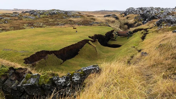 ” rel=”nofollow ugc”>tees.
I had a nice time after I first saw the photo at RÚV trying to work out from Google Earth which tee it was, but I couldn’t. I’ll never be a photo recon analyst!
Maybe the Golf club should put a notice on that bench “Possible Hot Seat . Get your Ass outta Here”
Looks like it might be the 13th hole based on this
https://icelandmonitor.mbl.is/news/news/2023/11/15/thought_this_was_a_lot_worse/
Some interesting photos and text detail on the path of the graben at the golf course – dunno if anyone can map that out, wonder if the bend mentioned is just a small wiggle on the line or a significant bend showing the dike’s path below ? probably just a small wiggle but golf courses are big enough to make me curious
It’s close to the street from Grindavik to the peninsulas tip (opposite the house).
Hi Lurking. Don’t stress about the procedure. Amalgesic drops put in eye after lying on bed. Uncomfortable when clamps put on lids to keep eye open.. Told to stay very still and stare at lights. Some water washed over eye. Then some ferreting about. More water. Some pressure pretty painless. More water wash. Then……….”OK you’re done” !!!!! Clear plastic eye cover taped on and I got up and walked out to waiting husband, All of a ten minute procedure. Dentist visits far worse! It feels a bit “Scratchy” now but already improved sight. Next one to be done at later date.Thank you and everyone else for kind comments. Lurking and all of you keep well and safe.
Many thanks for this post . I am so happy that others are also confused . I am not as expert as most on here but out of the muddle comes new learning for me. Looking forward to the next instalment. Also bear in mind that Hekla & Katla have female names which suggests that even in early times the Icelanders realised how unpredictable the volcanic,rifting and drifting behaviour of their Island was, and still is.
Speculative comments still come in legion. Is this en example of volcano fans dealing with a known unknown or unknown known known? Hope the mystery is resolved soon.
HI Carl, forgive me if I sound like a grumpy old curmudgeon; if I do, blame it on the fact that I have to be up at 5am to spend a shift locating earthquakes 🙂
Two questions:
1. You’re very specific about the magnitude scale used in your plots: Mw, the moment magnitude, derived from inversion of the W-phase. Can IMO really do inversions to obtain moment tensors and moment magnitudes for events as small as M2?
2: You say: “This famous expression lends itself to geology as well. The deeper an earthquake is, the harder it is to correctly locate the depth.” – from my experience, I would say the precise opposite. Even if you have a fairly dense seismic network, it will frequently be impossible to adequately constrain the depth of the shallowest quakes – those less than 5km. The problem is, at such shallow depth, the travel time difference between different hypocentral depths becomes extremely small – greater than the uncertainties and approximation in whatever crustal velocity model you’re using. And this effect is magnified when the crust involved is a volcanic ‘junk pile’ – trust me, I spent many many hours trying to constrain the depths of Taupo earthquakes in the recent past! The deeper an earthquake is (within reasonable bounds) the *easier* it is to obtain a robust depth. IMHO.
I would not say that they are curmudgeonly at all.
In fact they are good, so good in fact that I will have to answer in a bit, and after more coffee.
I also have do a wedding before to, but answer will come. 🙂
Remember, as a wedding planner the most important thing is how you emplace the air defence.
Fair.
A… wedding? Not yours, I trust?
With regard to the EQs, I had a thought; has someone been doing relative relocation here?
Nope, not mine, happily married to my wonderful insane little nut.
I got shafted with planning the wedding of a friend.
Bit extreme. The tabloid press only wants to do their job with the paparazzi drones
I fear that all drones will be shot down, same with any itinerant Paparazzi showing up.
I like make serious General note here on the event, despite event is not over (but it can be): I am just a sofa potato. But I do not have to answer for that.
But I had encounter with one of this leading loudouth scientist back at Holuhraun at 02:00 hrs September 8th, 2014, he doing something then that was totally unlike helping in any way possible. My guide there reinded me on that detail some days ago.
Four Icelandic “leading” Geologists ~ Volcanologists, have 4 different views. Note “views”. All predict eruption. None of them work at IMO. They are just advisors to local papers . And “Almannavarnir” (CPA) only listens to IMO. But the CPO are basically Police, State Police that is under Control by Ministry. Never admit errors. All mistakes covered over and blamed “not happening” (State Police never research their own actions etc.) Keflavik Police Chief was angry IMO suggested house owners can now save from their homes. Has CPA hijacted the eruption hype and “fail let go of the danger Phase”. Is there still danger for rescue workers? Is that not overrated?
Is that Volcano hype all make belive? Or do they like cows, piss just as one pisses, they have to piss too? Are they all just guessing? Today I see different data in IMO Reykjanes GNSS plots. Adding Grindavik 10 Nov (old) datapoint (today) from 1224 to 1334 hrs, yes today. Eight days late. Error / Correction. And moving slightly them datapoints for 11-17 Nov.
WTF is realy going on ( I fear) in this situation is “used” for secret hidden agenda. (I have IMO plots screenshots to HD if I need show it).
But I like tell this. I spoke to local Grindvíking shop-owner on Friday, noon, 10 Nov. He had low opinion on them fear mongers (Volcanologists), that speak “freely” of this no-existing eruption. True statement. I flew my remote controlled research camera several times and was not shot down over Grindavik or any other place. Nobody was doing anything all Friday.
I listened carefully to all news-stations all Friday (10th Nov) but nobody knew anything (really) what was going on. All day I was sitting thru (hundreds) of 3, 4 and even 5 (R) mwl quakes. Close up. I was both North and South of town – drove thrugh it even juat after 1500 hrs. Became Seasic from the constant movement. More than anything I have felt before. Nothing similar to 1995 Hegill fill in episodes og SISZ 6 R´s of year 2000, 2008 etc.
– Rest of day I was located at Arnarsetur Parking Spot (North of Svartengi) – untill moved base another 444 m to North, to be further away if Eruption came up at Arnarsetur / Sundagígar. None came. Wind was maximun for flying an RC 4K Camera, so I kept it on Ground. Almost 12 hrs lasted from first larger quakes till evacuation. In case of rapid inpending Eruption, was that acceptable?
But is there still an danger from eruption. Fissure one?
Is that really a danger? One can walk away I belive.
And media ban is for what purpose?
Hiding the truth?
This site is not for conspiracy theories. There is still a high probability of an eruption and if this were to happen just north of Grindavik, then escape might become impossible. The Icelandic authorities were right in ordering an evacuation. Yes, there is a chance there will not be an eruption. Also the longer the delay, the more likely it is that the eruption would occur near the Blue Lagoon, well away from Grindavik. But the authorities are judging that the risk is too high to allow for a return. I would have argued the same.
Remember the Italian seismologists who were convicted in court for not predicting a devastating earthquake and being too positive about the situation. That conviction was overturned later. It is always a difficult path between avoiding predicting catastrophe (there are enough sites for that) while being clear about the real risks. They are doing very well, with all data being openly accessible, regular updates, and clear information about the risks and probabilities. IMO should be congratulated
@Islander – Drones and paparazzi are forbidden at the wedding Carl is planning.
And it’s not in Grindavik!
Okay…
Coffee has hit.
1. As far as I know they are using the Moment Magnitude Scale (Mw) for all earthquakes. But, this would probably be better to ask them directly. In this case it was more how my brain is wired. I do all my work in MMS, so I typically write Mw on everything… I should probably check with them.
Anyway, for small earthquakes it makes an incredibly small difference, it’s for the big’uns that the difference grows as you know.
For anyone interested:
https://en.wikipedia.org/wiki/Moment_magnitude_scale
2. Good that you brought it up, I was once again a tad sloppy when I wrote and this should be explained for the general reader, you already know this by heart Mike, so sorry if I do it as a generalised answer for laypeople.
Imagine you have 5 seismometers spread out on a white paper. Somewhere on that paper an earthquake happen.
For horisontal component all 5 seismometers will give nice clear angles of direction, and when you combine those 5 directions you will find that they intersect on the earthquake spot with high accuracy since the angles will be distinct and different between the 5 seismometers.
Now, if you instead want the depth component and your earthquake is very shallow you will get just minute differences between the angles and that inherently lowers the precision in your depth estimate, whereas a deep earthquake will get clearer and more different angles (optimally) and a better depth reading.
Here’s where I forgot to explain myself, it was sort of an “obviously you need to recharge your car before driving it” moment and I sort of assumed this is general knowledge, whereas it probably is not…
Mea Culpa!
What I meant with what I wrote is sort of the next steps over.
With increasing depth and decreasing size the amount of attenuation will increase faster than the angle of degree advantage mentioned above is helping you.
Note I am talking about the small earthquakes only here, for something bigger it is indeed easier.
I hope I have clarified myself sufficiently and that the coffee somewhat helped, now wedding time.
As one of my best friends put it, “In the morning Carl is an idiot, in the evening he is a genius, manage your expectations accordingly and don’t talk to him in the morning.”… he is spot on.
The “official” table of picked quakes
https://skjalftalisa.vedur.is/index.html#/page/table_quakes
shows mlw magnitudes.These are ‘local’ mw magnitudes as in the Appendix, p.34, of (attention links goes directly to a pdf file)
https://www.vedur.is/media/vedurstofan/utgafa/skyrslur/2009/VI_2009_012.pdf
Now if they had just included the focal mechanism 😉
“It is somewhat ironic that my brain is operating mainly in a graphical mode, and that I think in visualisations and graphic models, whereas at the same time I am about as artistic as a four-year old doodling stickmen using a dead carp as a pen.”
I feel like-minded. 🙂
Thanks for the visuals, this is awesome!
A quick tip on how to read these would be nice, specifically the vertical images I’d like to get confirmation that if it is labelled with an “E” it means the view point is on the western side and we are “looking TOWARDS the east”. Is that right?
Is the sill at 5km depth under Thorbjorn being fed by a deep source under it only or also fed from a deeper magma chamber under Fagradalsfjall too ?
If so, the until now used description into 5 volcanic systems in Reykjanes, must be rewritten…
This is an ongoing debate now…
https://twitter.com/Icevolcanx/status/1726165120139796639
I don’t think the separation into 4 or 5 volcanic systems is meaningful anyway.
I for one would be happy with declaring that all, or at least most of this area in Reykjanes, is a large Volcanic Field and be done with it.
Most evidence seem to point in that direction anyway.
The Caveat is though to be found in Jespers comment below.
Fully agree with you and Jesper. Anything west of brimstone-mountain is just a garbled mess.
The North Atlantic Igneous Province (Reykjanes League).
I woud go by chemistry in the volcanic systems, If there is a clear chemical isotope signature for each of the Reykjanes volcanic system, thorbear have not erupted yet so No petrological work have been done yet to study this I think. But If each ”system” have a clear induvidual chemical variation fingerprint that means each is formed from its own melt zone and so are induvidual volcano systems feed by its own mantle melting roots If thats the case, but I dont think fully and I think none knows, magma is sourced from partial melting of a solid mantle and that explains the huge variation of isotope variations among volcanoes
If deep magma chemistry is similar along the Reykjanes volcanic systems then the concept of individual volcanic systems at least in Reykjanes area is very blurry and specialy so If they can feed magma to eachother as they discuss here.
Ding!
Jesper hit the nail on the proverbial head here.
And we will not know until we get a fresh batch of lava to toy with in a laboratorium.
I think Fagradalsfjall was separate, given that it hadn’t erupted for multiple cycles, and there was a rather separate few intrusions at Thorbjorn over the same period of time. I thought what we had seen from the earthquake swarm beginning 26th Oct was magma moving across from the sill west of Thorbjorn to the dike east of it – that was what the pattern of the quakes signified to me – Eldvorp could well have been next had it gone another way. I do not see how Fagra is involved in this, it is just another section of the interaction between plates where obviously quite a lot of stress had accumulated (and been released, at least partially). That stress has now been transferred further down the peninsula to Svartsengi.
Now magma is constantly generated probaly setting up the conditions for frequent rift eruptions for decades to come, If the magma comes from under fagradalsfjall we can expect this to last for quite some time indeed, and same if torbear had a constant inflow since 2020 as well
LOL! That image is so perfect! 😀
https://pbs.twimg.com/media/F–h0RgXIAAlysm?format=jpg&name=large
The first two are like “Wuuuuut?” biiiig question marks. The third clearly radiates. The fourth couldn’t care less, he’s far away in his thought bubble. And the fifth is the only one on the eurasian plate, so he began to drift away.
Spat out my cocoa drink.
Somebody wrote an article about this..
https://twitter.com/Alberto_Carac/status/1726209456785211439
Magma plumbing architectures and timescales of magmatic processes during historical magmatism on the Reykjanes Peninsula, Iceland
https://www.sciencedirect.com/science/article/abs/pii/S0012821X23003916?via%3Dihub
An older article, last updated Nov 13th, that also presents really cool diagrams and plottings:
https://earthquakeinsights.substack.com/p/volcanic-earthquakes-in-iceland
/Steve, I do not know why you are ending up in the Dungeon’s all the time.
While we try to figure out why please enjoy the cookies and keep on posting.
Oh … I thought that „waiting for moderation“ is standard procedure here. 😀
I think the system knows that I‘m a bit spammy when I get overly excited. 😉
// Admin – Unspammed now, hopefully, it’ll settle down from now on so you don’t have to 😉
Nope, I still get to be in the moderation queue.
I have made a quick change to your settings, can you please test for me?
Woud be fun to allow forests to grow all over Iceland as the climate warms up
( needs to reform the damaged soil also ) with forests regrown there we coud introduce a whole biosphere with deers and elk and wolves and bison and wild horses, Infact Many large siberian and arctic fauna woud do well there already today, reindeer is already introduced.
Iceland have no natural large land animals only foxes as its been covered by Ice Ages for so long, so maybe ”playing god” maybe okay in these empty landscapes of Iceland that lacks biodiversity overall. Being much larger than yellowstone its should be suitable for a massive terraforming project with viable populations.
But before we makes Iceland into Pleistocene Park 2.0 we needs to work on the landscape vegitation getting the lands more productive and soils in better shape so trees and other plants can grow better
But Icelands goverment will never allow my massive crazy terraforming plans for Iceland so my dreams of a Nordic yellowstone will be cancelled
Whats Icelands coldest location today? it it Grimsvötns caldera? I also knows that the Holhuraun area thats sheltered from warm ocean air can get incredibely cold too during the winter, supprisingly low temperatures for souch an oceanic location as Iceland is, but the interior have its own continentality
Interior Vatnajökull definitely. Over five hiking trips I’ve spent a lot of time on Vedur looking at temperature maps, the greatest anomalies and least variance seems to be predictably on the largest glacier. Interior Myvatn down through Askja is pretty cold, too. I hiked Krafla last year in November and it was damn near polar conditions, though of course weather varies as it does all over the island.
Iceland definitely still has a polar / tundra climate inland and away from the south / west coasts. Akureyri is somewhat moderated as well, but it can start to get really cold very early in the fall.
Iceland is definitely heavily moderated in its climate by the gulf stream and not as cold as it should be given the extreme latitude, but it’s not exactly warm either. Very easy to be caught off guard, and from a hiking perspective I’d definitely consider Iceland’s climate as “harsh” outside the summer. I definitely take full precaution.
Different going from your home to the local N1 for a bite and fuel, but yeah.
Thats the case with most Nordic Countries moderated by the Gulf Stream, Norway coast, South Sweden, Keflavik and Westman Islands are mostly snow free all year around due to oceanic moderation, having rainy gloomy winters in Gothenburg and Copenhagen so usualy sits well above freezing there too
Even the colder northen parts of Sweden and Finland typicaly rarely goes much below – 20 c when Siberia reach – 45 to – 60 in winter for any comparsion with other places at same latitude. Winters are long in Northen Scandinavia but they are quite mild but months below – 10 is common, but its true that souch dry crisp bright snowy pink skied winters are preferable over the rainy coasts and wet gloom further south
Carl that lives in Malmö may have the worst winter in all of Sweden .. rain and gloom and skeletal trees and the fetid outside smells of worms and dogs pooping outside at night leaving nasty piles that runns down with the waters in black degenerating rivers of sorrow at street sidewalks
We really want to get to Scandinavia sometime soon! Been a dream of mine for years but keep getting diverted back to Iceland as it’s sort of a hikers and volcanoholic paradise.
But I would love to do a tour of Norway & Sweden. Would also love to see Lapland and finish down in Denmark. I’ve been all over Europe but never further north than Munchen.
I wants to move to Iceland as Nordic Citizen when I found a work skill..
Volcanic paradise indeed
Do they have much seaweed around the coasts of Iceland or is it to cold for kelp and bladderwrack to grow? Many years ago in the town I live in, the seaweed thrown up on the beaches were regularly harvested for laying on the field to fertilise them. Then the UK joined the EU and pair trawlers were allowed to fish far too close to the southern coasts, They destroyed the kelp forests that were keeping the fish in the area. Then the fish became scarce on the south coast because of overfishing and the destruction ot the kelp forests that were the safe places for small immature fish to hide. Sadly mankind think they know better than farmers and fishermen from so many years ago. In the old days farmers and fishermen worked together for the mutual good but now all fertiliser is manmade and causes all sorts of problems for the inland watercourses.
However Jesper, to go back to my question of seaweed, It is brilliant for fertilising and building up layers of good soil. If only the modern so called clever people would look back to the old days and ways of farming then perhaps Iceland also could become a green and pleasant land, at least in the areas where the Gulf stream warms the coast. I totally commend you for your thoughts and dreams for the future of Iceland. I know I have probably a very simplistic view of the probelms of agriculture in Iceland but I am positive that one day in the future that Iceland could and should become a green land.
Icelands seas are one of the most productive on the planet so yes lots of seaweed there, Infact there is huge kelp forests in Iceland that are teeming with life thanks to the nutrient rich cold waters.
Iceland already is pretty green in summer, the grass and moss and souch, Im talking about terraforming Iceland turning it into something like a massive taiga rainforest and introducing taiga species when the huge forests are there.
Thanks for that information jesper. Well with lots of seaweed and Gulf stream warmth in the summer I could grow a nice garden there. Not with the sort of plants I currently grow of course but I am sure with a large greenhouse to overwinter plants then I could happily live there with a colourful garden!
Plus the bonus, SNOW in the winter! I soooo love snow and very rarely get it where I currently live, Sometimes even a few years without even a snow shower! So sad!
Also, the energy prices are so low in Iceland that you could heat and light the greenhouse.
Now you are seriously tempting me Carl!
You save thousands a month with souch cheap energy! But the home and apartment rents, food and goods are just as sky high prices as anywhere else in the Nordics that typicaly have super high living standards as Iceland defentivly haves as well
It you live in Keflavik and Reykjavik that have alot of oceanic moderation from the Gulf Stream you probaly wont have much snow at all in the winter, Icelands south coasts are pretty warm in winter for being latitude 63 – 64 not uncommon with +7 c in january
While Siberia at same latitude can drop to below – 60 c
My biggest problem would be that the UK pension is seriously low compared to the rest of Europe so I probably could not afford to live in Iceland
Still, it is important to always look at the good things you do have and I have many good things in my life, a good husband and good children who care a lot about me. Family in my view is the most important thing and I have been blessed with that.
Iceland: is it only me that thinks this intrusion has stalled for a while? It had a good go a few days ago with a surge up to the top, but it failed to break through. I’m wondering if it has stopped for a cuppa and put its feet up (metaphorically) before having another go. Which could be weeks, even months away.
Feel free to heap criticism and abuse on my thinks. It’s just me wondering about it.
Be careful, the maybe the gods of the underworld want to make us believe that it is over for now. Come to think of it, it could also be possible that the gods want us to believe that it is NOT over, because it looks as if it is over and we choose not to believe it? A double bind or a inverse double bind?
IMO were thinking yesterday that magma was very near the surface now. So an eruption is still highly likely.
The 3.7 3.1 km N of Krýsuvík with a depth of 4.9km is interesting. Activity at Krýsuvík tends to precede activity to the west so give it a few hours / days.
I noticed that 3.7 with interest.
I’m inclined to agree with something Carl said a few days back.
The feed from below into the intrusion continues, so the new (? is it new ?) area is now pressurising. And when the pressure reaches a tipping point ??
Also… Talk about these hard layers that they magma may struggle to break.
Well, would 120 cm+ drop not create cracked areas in these layers very close to the dike ?
If magmatic gasses can reach the surface, there is a route somewhere.
Think the 120 cm+ drop was the result of fractures not the the other way round.
Magma pushing the ground upwards caused over extension so an existing fault slipped. Does not preclude new fractures.
Note the large earthquakes to date have not been at eruption sites but on nearby faults. Seems they may be needed though to let the magma rise.
Another large quake might not be needed now to let magma breach the surface as it is so close, but if there is one, I’d expect an eruption fairly soon afterwards.
I was not saying if chicken or egg came first at all. Merely that any rock subjected to that kind of movement (extension ?) to the extent that rocks around it had failed, would either have to have some serious plasticity to them, or they may have fractured sufficiently to allow at least some magma to rise.
With the deflation of the sill and immediately inflating again, at a faster rate no less, the entire system is just building up pressure for another ‚squeeze‘. I just wonder how much pressure the system can take. The longer it goes the more impressive the show. Bad for town though.
Your comment reads like an engineering conversation from Star Trek… and funny until the last sobering sentence. Many lives disrupted, and the financial loss of homes and businesses…
https://i.imgur.com/6PRiGkG.jpeg
Recently updated my workstation (ok, gaming station!) at home and it does an amazing job doubling as a volcano-watchers wet dream with its 43 inches of fun!
I’m hugely impressed with the camera coverage provided by MBL/RUV, and if we get an eruption where they think (and hope?) North or West of Hagafell, we are most likely able to follow it from at least 3 (or 4, maybe even 5) different angles in real time.
Posting the cameras again for visibility:

1. Sylingafell: https://www.youtube.com/watch?v=Qvw5qh5K4wI
2. Langihryggur, 5. Thorbjørn (South), 6. Reykjanesviti (multicam): https://www.youtube.com/watch?v=804nPrAUAxg
3. Thorbjørn North: https://www.youtube.com/watch?v=P1e_MWJ1nQc
4. Thorbjørn East: https://www.youtube.com/watch?v=BerZJunvSik
7. Svartsengi: https://livefromiceland.is/webcams/svartsengi/ (currently offline)
8. Husafell: https://www.youtube.com/watch?v=HJWj-1RIIgM
Thanks. Will be the most watched fissure birth on record. Unless the weather becomes Icelandic.
thanks so much for doing this, i find it very helpful 🙂
Thank-you for the overview, Tor!
Is Blue Lagoon (visible on webcam of Langihryggur) currently the only steam source or are there more normal ones?
I believe there are at least two sources of steam in the area. One is the Svartsengi power plant / Blue lagoon, and the other one on the South-Western tip of Reykjanes close to the Reykjanesviti camera.
Currently the Langihryggur camera is blocked by water droplets/fog, so I can’t check which are currently visible, but I seem to remember that there is one or multiple camera’s who got both the Svartsengi and the Reykjanes steam in frame. One of them may be the panning Husafell one.
I live in Iceland. We’ve had a magnificent fall with lots of sun and little wind – perfect volcano viewing weather. I am scheduled to fly up to Akureyri on Tuesday morning, but just got a text from Icelandair switching my flight to Monday as they anticipate domestic flights will all be grounded. Veðurstofan has not yet issued an alert, but the forecast for Tuesday looks really nasty with high winds and heavy rain. 9am Tuesday is now my official bet for the eruption…. All is not lost – they say that sunny weather returns on Thursday!
I drove up to Akureyri last November and it was the most fun road trip I’ve ever taken in my life. We stayed a night in Reykholt (near Husafell) and did the drive from that point in one day. I remember that morning getting back on the Hringvegur was the foggiest I’ve ever seen in my (to that point) four trips to the country. I couldn’t see more than a few feet off the road for at least the first hour or two of driving, it was quite the experience.
I know it can be treacherous driving in the north this time of year, but it was really an incredible experience.
All of Iceland is beautiful but the north is really special to me (and I prefer it with tons of snowcover).
43“ … mine is 125“ roughly. 😀
But okay, that‘s the projector. Regular desktop monitor is 49“ (32:9). That means I can watch anything from two angles at full HD. Last time I did that was during soccer world championship. They sometimes show two games at the same time, so I had them live-streamed to both sides of the screen simultaneously. Wouldn‘t want it any other way anymore.
And just so I can get work done, I am streaming on my iPad and phone just under the monitor. Usually webcam and DAS feed – I can’t miss the start of it. I have both running round the clock even while I sleep. Which made me realize how unreliable all that tech is. Streams just stop every so often. And don‘t get me started on audio, the webcams don‘t stream it, I set the stream to mute, yet Youtube insists that I must not play any other audio while streaming. 🙁
Klaifarvatnet with 3.7 earthquake, but Grindavik with Microquakes of Magnitude 0-1. Do they show the progression of the dyke?
On odf station this is not weat (magma) quakes?
http://skjalfti-tremor.com/tremor-fagradalsfjall.html
I mean wet quake…
In case you missed that, I did … RUV has a mosaic online that’s actually useful:
https://www.youtube.com/watch?v=kXD4A9uFHcg&ab_channel=R%C3%9AV
Thorbjörn + Husafjall + Sylingafell + Eldvörp – all “hot spots” covered, no fancy graphics overlays or annoying chat.
This is a lovely feed and worthy of saving on the ‘Ongoing events’ page, I think.
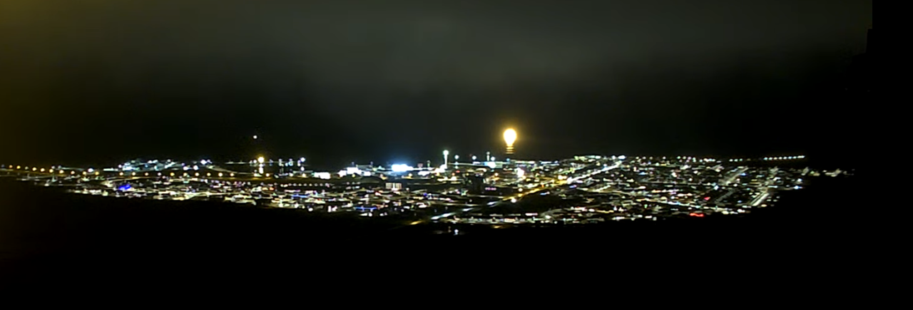
There seems to be a bright spot just North of the East side of Grindavik this evening. Too low resolution to tell what it is – could be a lot of floodlights for some kind of activity but I don’t remember it being there before and it is fairly large and very bright.
Most likely the greenhouse located 800m NW of town,
It’s visible and very bright on the Grindavik-, Langihryggur and Husafell-cameras.
Yes, Steve mentioned that, too. Brightest I have seen it so far. Even though it is hard to resolve in the camera views, its shape seemed too regular to be an eruption.
As people here usually says; if in doubt its not an eruption 🙂
Also I have to correct myself, the greenhouse is located NE of Grindavik and not NW (oops!)
Cold weather incomming for Iceland in next few days according to the windy app program, even in Keflavik and Vik the warmest parts of the mainland Iceland it will get quite cold according to the models, Winters in Iceland is overall very mild but also very swingy depending of which airflow is present, when southerly winds are usualy present its very mild which typical/ normal, during souch conditions westman Islands can be as warm as +9 c in january during souch windflow, but when northen windflow from greenland is present it can drop to – 10 in Reykjavik, and last year it was an extreme case of that with subzero for weeks weeks.
“Land rises much faster at Svartsengi”
https://www-mbl-is.translate.goog/frettir/innlent/2023/11/19/land_ris_mun_hradar_vid_svartsengi/?_x_tr_sl=is&_x_tr_tl=en&_x_tr_hl=en&_x_tr_pto=wapp
That’s what I noticed on the elevation diagram because it was rising at least 30% faster.
It can be a soda for sure!
https://twitter.com/volcaholic1/status/1726282507136471251
#Iceland: The land near Svartsengi is now rising much faster than it did before the earthquake tremors on November 10, about 5.5 times faster. According to volcanologist Þorvaldur Þórðarson, the influx of magma is ten times greater than before the seismic activity.
The magma is flowing into a reservoir at a depth of 4.5 kilometers, and the rate has increased from 5-7 cubic meters per second to approximately 50 cubic meters per second. Þorvaldur suggests that if this rate continues, Svartsengi may regain its previous position within 5 to 15 days. The accelerated uplift is attributed to the magma creating space and lifting the Earth’s surface.
Regarding the likelihood of volcanic activity in the area, Þorvaldur believes the chances are increasing due to the land uplift. He emphasizes the importance of considering preventive measures in light of the emerging reality and entering a volcanic period, encouraging planning for potential eruptions to minimize their impact on society and infrastructure.
Impressive
https://twitter.com/Alberto_Carac/status/1726209456785211439
https://twitter.com/Icevolcanx/status/1726279159108846012
Shall we expect the fissure to begin very violently on a long line like “blitz eruption”? Maybe there is a solid rock layer that until now resists the rising magma strongly. When this is overcome, everything may escalate very fast, very heavy and spectacular with a Curtain of Fires and lava flash flood. A bit like the first hours of Mauna Loa’s typical eruptions.
Exactly I think some Krafla like fissures are comming up
Maybe even like Holuhraun at first. With the supply rate and sill to deflate another time, seems quite possible starts at 1000 m^3/s and then slows down to still close to 100 (since 50m^3/s now when highly pressurized system). It just won’t last for six months like Holuhraun did.
The pressure is actually pretty low as these things go.
As I mentioned before, the Holuhraun had a systemic pressure two order of magnitude higher, and it was fed by about 500 cubic kilometers of magma reservoirs.
This will be a small eruption, but perhaps a lengthy one.
I was wondering about the possible early signs of a beginning eruption. I’m mostly curious about how much warning we can at most expect to get ahead of time before we start to see fumes/smoke on the ground (which I think means: it’s only a matter of minutes).
So what could indicate an immediate eruption to authorities in this particular instance, and how much time could that give us realistically?
1. Rising SO2 levels – provided this happens at daylight.
2. Infrared images (helicopter? satellite?) that show elevated ground temperatures.
3. A certain pattern of (micro)quakes.
4. Significant change in GPS elevation.
Anything else I forgot?
I want around for the Litli Hrutur eruption, but from memory of the two Fagradalsfjall eruptions, there was a period of reduced activity immediately prior. I’m less clear on my memory of when the tremors started. I’m thinking it was in the immediate hours before, with very little warning, but the tremors I remember could have been after it started.
The observation of Tremor would be a good indicator for the onset of the eruption. Look back at Fagradalsfjall on 10th July:
“During the prelude to the eruption, IMO scientists became aware of increasing levels of tremor at a seismic station at Fagradalsfjall. Episodes of heightened tremor occurred on 8 and 9 July, and again today in the hours before the eruption broke the surface. Similar periods of tremor were noted just ahead of similar eruptions on the Reykjanes Peninsula in 2021 and 2022.”
https://en.vedur.is/about-imo/news/earthquake-activity-in-fagradalsfjall-area
Thanks that confirms my memory of the first two events. With all three showing a similar pattern, it is most likely that this will follow a similar pattern, I would think, not that I’m an expert by any means.
The disadvantage of tremor is, that is likely not well felt by humans. So I’d suppose if we walk around in Grindavik, we wouldn’t notice it. Wind and weather would be more noticable. We would notice that the eruption begins, when it really begins. Then we’d had to run for our lives and to the hills …
The wind has caused many false alarms in Iceland, at least amongst the non-experts.
Thanks for this pointer! I haven’t thought of checking the news archives. Too bad I have to read them bottom-up, down, up, down, up, down … but it does help put things into perspective.
“small eruption” … oh wow … did not think of it that way 🙂
I have the feeling that the present earthquakes are also a possible indicator. There has currently begun a swarm of earthquakes both along the graben/sill and the E/W sides. Some happen off-shore where the southern 10-20 percent part of the sill is. The extension of land by the intrusion and the force by rising magma may produce more earthquakes than the Fagradalsfjall eruption.
re 2: I doubt we could see any ground temp changes from the air. Rock itself is a very good insulator so I would be surprised if i.e. a thermal drone like from Just Icelandic could pick something up that predicts the eruption. We could potentially see a rise in geothermal water temperatures, I think.
(I’m not a Geologist, so someone may correct me here if I’m wrong)
Did Steve get in on his own, or did someone let him in?
https://www.youtube.com/watch?v=TF44Z7wta-s
The cam on the right have smoke rising from the base of the mountain, not the one from blue lagoon
There are low clouds around and rain drops on the Webcam. Both falsify the optical view of the camera.
I’d assume that gas/steam emissions will only last for seconds or a few minutes until the lava comes up. Added to this it is possible that the eruption will start very heavily and violently like the opening of a champagner bottle.
Thanks!
The tremor graph currently looks like nothing is going to happen today:
I note that on the Tremor chart for Grendavik, that the blue and purple lines are beginning to cross their vertical order — that is, blue rising above purple. If that sounds mythological rather than scientific to you, it does to me as well.
But it mimics what occurred right before the quakes on Nov 10.
I guess I’ve got a bit of a cargo cult volcanology going on there.
Lava flows from the last three volcanic periods in Reykjanes (as well as the current one).

Thank-you for the map, Bjarki!
I’ve looked for information about older cycles. We know relatively much about the 900-1300 eruption period, but little about previous ones. The Middle Ages may bias us, as if you ask only one person about his/her party preference to get a prediction for the next elections. The orange colors of 1900-2500 BP (around Roman Empire’s Age) show that this cycle was a bit more towards Grindavik than the Middle Age cycle. Interesting that also the Krysuvik lava of Roman Age was closer to Grindavik than the purple one. Is a westward leaning eruption of Krysuvik/Fagradalsfjall accompanied by a eastward leaning eruption of Svartsengi?
Really nice map, thanks.
LOOK!
Grindavik has an idea! I wonder what it is …. 😀
On a related note: I wish they’d have another power outage. That greenhouse is glowing way too much in the mist.
I have both the multiviews on:
https://www.youtube.com/watch?v=kXD4A9uFHcg (RUV)
https://www.youtube.com/watch?v=804nPrAUAxg (LFI)
If it’s true about the rate of reinflation at Svartsengi i’d expect the next influx within 5 days or so – could be enough to push it over the edge. Unfortunately jumped the gun with my previous prediction
I am sorry, I will have to postpone the launch of part II until tomorrow afternoon.
I am way to tired after the wedding.
And torbear resumed rapid inflation: )
The sill is rapidly refilling now and systemic pressure is going up quite a bit now.
Only Grindavik is still moving down, but that is due to the Grabenisation, I suspect it is going up due to the system pressure, but the Graben still dropping is counter-affecting and we get just a tiny drop.
When the eruption starts we will probably see a second big drop there.
Yeah, not excited about the sill reinflating, because that means return to predike situation of large quantity of magma that can be squeezed out like toothpaste by a few dozen km^3 of rock on top. Maybe Chad’s thought about what would happen if a dike filling at 1000m^3/s expanded clear to the surface unfortunately is less theoretical than one might hope. We do know this system tends to do rapid eruptions, was thought that dike filling rate might mean slower than norm, but with the sill recharging… Currently filling they think at 50m^3/s, but once pressure relieves sill can empty *much* faster than that.
Might still be tourist eruption if kind enough to do this far enough north on the dike. And would be magnificent spectacle. Won’t last near as long as Holuhraun but the first hours might easily be as fast. Heck Holuhraun after opening was about 100/m^3/s. If this system is getting 50m^3/s while considerable pressure, might be able to keep up a similar rate even after first few hours. It just won’t last for 6 months like Holuhraun did…
there is very low probability for it being a big opening, the systemic pressure is to low for that.
Remember that Holuhraun was fed by 2 central volcanoes and a separate deep feed, the pressure was a couple of orders of magnitude above what it is here.
If you get something slightly bigger than Fagra II you can coun’t yourself lucky.
Instead it could be a prolonged event.
Carl the visible fissures are all from curtains of fire. Mauna Loa manages to do eruptions at over 1000 m3/s from its summit with a smaller magma chamber at present than the one under Bardarbunga. This is basically the same as that in principal, about the same depth of storage, magma composition, etc… the eruption wont stay at high rate for long but the first few hours could very easily be as big as the eruption rate of Holuhraun.
Too much we judge eruptions on their volume, when it is their intensity that does the damage. This place is low volume but high intensity.
Yes, they are from fissure eruptions, but that does not equate high eruptive rate, time will instead fill in for that.
And using any central volcano, Hawaiian or Icelandic, is not going to help with understanding what is about to happen.
A central volcano will always have a higher systemic pressure, and a way higher magma reservoir.
It is like comparing a very small mouse with an elephant, and then saying that they will shit the same amount since both are mamals.
This is likley defentivly not at melt generation rates so probaly is a large deep pressurized stoorage thats been activated as well as some input getting in from mantle melt generation
Wants the mantle melt rates in the local area? It coud be rather high since its in a rifting episode, woud be good with an eruption to obtain a lava sample to compare the isotope compositon towards fagradallsfjall lavas to see If they are the same..
While we wait and see, let’s not forget this golden oldie:
“…the activity has decreased significantly of late. The tremors are both fewer and weaker. New satellite images support what scientists have believed, that the flow of magma has slowed down significantly and that magma is even starting to solidify in the magma tunnel.
“Maybe this chapter is just coming to an end. I would doubt it’s over but yeah, it seems like this chapter is coming to an end without us being able to say it but it’s looking like that.”
And as a result, the probability of an eruption decreases every day?
“Yes, I would say that, I don’t expect an eruption in the near future based on the current trend,” says Benedikt Ófeigsson, a geophysicist.”
https://www.ruv.is/frettir/innlent/2021-03-19-a-sidur-von-a-eldgosi (translation by Google)
The Geldingadalir eruption began 81 minutes after this article was published.
It is the only time I have openly had an argument with Páll, ending up with me betting a beer on it, and 60 minutes later I got to issue the whalest of “Told You So’s” in volcanological history.
It was so obvious that it was about to blow, I literally had to pick up my jaw from the floor as I read it… and I freely admit that I exploded like Krakatau.
Come think about it, he still owes me that beer.