
Grindavik nowadays is the proud owner of the golf course where it is easiest to make a hole-in-one. Photographer unknown, borrowed under fair non-profit eductional purpose.
Due to this article being so graphics heavy, I had to break it up into two parts, with the second part coming tomorrow evening.
It is somewhat ironic that my brain is operating mainly in a graphical mode, and that I think in visualisations and graphic models, whereas at the same time I am about as artistic as a four-year old doodling stickmen using a dead carp as a pen.
This has led me to rely on some truly talented people producing the visuals through the years. Among them are the talented Andreij Fliis of Severe Weather Europe-fame. Grindavik brought him out from his weathering, and he delivered some truly stupendous plots for me to expound upon.
Albert was also the sounding board for this, and he did the heavy mathematical lifting in producing the volumes and flow rates mentioned tomorrow.
What came out in these extremely exact plots is that from a geologic, seismologic, volcanological and tectonic standpoint a true Cherenkov coloured swan is happening.
For those not familiar with Cherenkov radiation, it is blue incandescent light caused by neutrons radiated from a reactor core through water and these fast neutrons are travelling faster than light through the water. There are also other instances where Cherenkov radiation can occur. And if you believe that nothing can go faster than the light in water, well then you can go ahead and argue with Einstein.
What I am trying to say with this analogy is that what we are seeing is exceedingly rare, a once in a lifetime opportunity to see a geologic process. After all, you rarely see swans that glow blue in the dark.
The MAR & The Dyke
The regular readers in here know that I always harp on about how important it is to only use earthquakes above a certain size that are appropriate for the area. The reason is that it is easier to manually correct a larger and more distinct earthquake compared to a smaller one, this makes the larger ones more exactly placed on the map.
In Reykjanes 2Mw is enough to get specific EW/NS-locationing, but you need 2.5Mw to get a good depth-location.
I also always harp on the necessity of only using manually corrected earthquakes when making assessments.
If one does not follow these two rules you will be led astray, or be overwhelmed by what you see. I guess that most readers have seen the hopelessly messy standard plot put out be the IMO that is containing uncorrected earthquakes of all sizes, and that is including “ghost earthquakes” that the automatic system is picking up from reflections.
During a large seismic crisis this otherwise nice map is rendered useless. Now, put that messy map in your head and compare them to the laser-sharp plots by Andreij below.
They are in turn, all corrected earthquakes, 2Mw and above, 3Mw and above, and finally Mw4 and above. In all of them the data timeframe is June to October 15. Note how the details emerge.

All corrected earthquakes June – November 15. Copyright Andreij Fliis, used under written permission.

All corrected Mw2 and above earthquakes June – November 15. Copyright Andreij Fliis, used under written permission.

All corrected Mw3 and above earthquakes June – November 15. Copyright Andreij Fliis, used under written permission.

All corrected Mw4 and above earthquakes June – November 15. Copyright Andreij Fliis, used under written permission.

Image borrowed under non-profit fair-usage.
What we are seeing is what I believe to be the clearest locationing of the Reykjanes part of the Mid-Atlantic Ridge (MAR) to date. It was always a fairly amorphous and badly located entity. It was not until this event that we got the data needed to pinpoint this part more accurately.
One of the reasons for it being sort of shy is that it is predominantly strike-slip faulting, with a minute part of spreading. Whereas Iceland is rifting apart at a rate of 2.8cm per year, this part is moving along each other instead.
Rifting is comparatively silent compared to having two tectonic plates rub against each other in a noisy manner.
At many points a strike-slip fault will lock against outcrops building up a lot of strain. The total pent-up strain in Reykjanes is above Mw7, and in this section it is above Mw6.
This is why the bulk of the Mw4 earthquakes are along the MAR section in these plots, and not along the dyke/Graben formation.
It is also likely that this area is pre-disposed to Graben-formation and as such already weakened.
After all, normally a Graben/dyke event of this size would have come with an Mw6 earthquake along the fault.
It obviously also rifted apart and those are as mentioned a bit “quieter” compared to other modes of faulting.
We also see the Sill that was produced during the intrusion of magma, and we clearly see the dyke as it went up North of the MAR and down south into the Atlantic.
Now it is time to go deep.
Into the Abyss
“Deeper and deeper, harder and harder”
General Kyrylo Budanov
This famous expression lends itself to geology as well. The deeper an earthquake is, the harder it is to correctly locate the depth.
Here we have two depth plots by Andreij showing the shape of what is happening at depth, both are filtered with a cutoff at Mw2.

Vertical image, corrected Mw2 and above earthquakes June – November 15. Copyright Andreij Fliis, used under written permission.

Vertical image, corrected Mw2 and above earthquakes June – November 15. Copyright Andreij Fliis, used under written permission.
The first image is showing the depth of the Sill and the dyke as it passes by Grindavik. From this we get a good visualisation of the depth and size of the sill. We also get a feeling of how the dyke dips downwards as it enters under the sea in a slightly unusual fashion.
The latter indicate that there’s a difference in the geology of the plate as it enters into the ocean, it is far harder and less easy to fracture nearer to the surface. One probable reason is that no previous eruptive period has fissured this far out.
On the second image we can also see that the dyke dips down at the northern end. This is logical since there are comparatively fewer eruptions North of the MAR, and there should be less faulting in this direction and a far harder overburden to crack open.
In the middle you see a few deep earthquakes that belong to the deep feeder from the MOHO. Above that you see a region of more shallow earthquakes making the dyke to all points and purposes look like a funnel. This shallow area is where an eruption is most likely to happen.
There is also a curious aseismic area in the middle of the left plot on the second image at a depth of between 5 and 3.5km. At a central volcano I would have assumed that this is the location of the magma reservoir, but supposedly there is none here.
It could though be where the magma ended up in the 2019-2020 intrusive period. Let us just say that unexpected aseismicity normally indicate a very hot and ductile area and I will leave it up to you to draw your own conclusions about the reservoir, and if you are a young strapping Ph.D.-student, please feel free to include us in your references if you write a paper about it.
I will here leave things hanging until tomorrow, then I will deal with temporal evolvement, and draw my conclusions.
CARL REHNBERG, ANDREIJ FLIIS & ALBERT


Is it true that the MET office is now withholding data?
Svartsengi (SENG) GOS datagram shows in red letters „last datapoint nov 19th“ today on the 21st.
Let us be polite and say that some key features is no longer prioritised for the public domain and that some have been taken offline and leave it at that.
The GNSS data is still available, all the rapid 4 hour plots are current:
https://strokkur.raunvis.hi.is/gps/8h.html
Mike:
A lot of GPS stations in the Svartsengi/Grindavík area are showing rise. Is this due to a sill refill? It almost seems like the sill to dike channel got restricted. It is very interesting to see this rapid rise.
Here’s SENG; the more rapid inflation continues at the same rate, “Last datapoint 21/11/2023”
I glanced at the webcams this morning (UK time) and this gave me a chuckle. Icelandic weather at its best!
https://postimg.cc/yWzKvs8X
The Green House effect doesn’t help. But the weather makes big white breaker on the coast:
Cambridge removed their old stream of the Hagafell seismometer and put up a new one here: https://www.youtube.com/watch?v=Ne4w0Naff0E
Seems like the changed the scaling quite a bit too. Now everything doesn’t seem as dramatic as before :).
Where do we see potential low-frequency quakes preceded Fagra I 2021?
Yeah, they got a bit tired of all the “Oh my God! The world is gonna end by that M12 deathmageddon-earthquake!”
are you sure this one is live? looks like a recording to me …
It was live earlier today when I posted the link. Maybe they switched to another stream again….
Is this a typo or part of testing some response system?
“Snaefellsjökull (Iceland): Explosive activity continues. Volcanic Ash Advisory Center (VAAC) London warned about a volcanic ash plume that rose up to estimated 20000 ft (6100 m) altitude or flight level 200 and is moving at 30 kts in SE direction.
The full report is as follows: 17KM PLUME OBS VA DTG:21/0600Z to 20000 ft (6100 m)”
https://www.volcanodiscovery.com/volcanoes/today.html
Thanks for all the exellent work VC do and for all the good commenting. 🙂
Snæfellsjökull hasn’t erupted for 1750 years.
Yes, I know. If there was an eruption there we would definitely have known it, so I am just curious as to why the report is there. It is not April 1. either. Or deathmageddon day.
I think that’s an outdated warning they put out 1750 years ago. You know, for the dragons. 😉
That is really odd especially as they have the report next to a satellite image of Mayong volcano.
Perhaps someone had a drop too much last night!
Forgive typo Mayon!
I think you nailed it Alice. But I guess last night must have had certain mushrooms on the meny to mistake Snæfellsjøkul for Mayon. Or even worse; misspell it. 😀
Mushroom-eating dragons are responsible for typos, and Iceland has a strike-slip fault.
You learn interesting things on this blog.
They did this with Öræfajökull last year and I nearly fainted thinking it woke up suddenly. Was very poorly marked as some sort of test.
Same here it looks like, I woke up and checked my app to see Snæfellsjökull erupting and in my morning fogginess nearly jumped out of the bed…
VD is incredibly annoying with that stuff. Good aggregate of volcano updates otherwise, but always have to seek verification elsewhere or check the sourcing inside each update.
I experienced this once with Katla. First I thought Katla really had done a 15km high eruption, but later I saw the label “Exercise”. It is an internal exercise of London’s VAAC.
VD is good to get new volcanopictures and sometimes good news, but doesn’t controll the issues well. I like the background information about the currently active volcanoes. Sometimes there plop up volcanoes I’ve never heard of.
If it was a mistake from Mayon, then they would have to make a mistake on the VAAC as well, as it wouldn’t come from London. It looks more like a test message that slipped out.
Probably a VAAC test of an explosive Icelandic eruption, that VD picks up and puts in their live update feed… brilliantly.
Yes it was. A warning about the exercise was posted in the Icelandic Geology facebook page.
Thank you Tomas.
No mushroom, no deathmageddon. But. That’s part of the fun hanging out on VC. A gazillion fun theories. Usually including sheep. 🙂
It is a test run, they just forgot to write TEST TEST TEST in the first line…
First line of the advisory was Status: EXER
Second to last line read: RMK: VOLCEX23 EXERCISE
Volcanodiscovery always does this.
Just to be clear, those VD reports are automated, there is no filter for test VAAC alerts. It annoys me too but I always correct the alert status as soon as I see it (I am allowed to change statuses and post articles (can’t do the latter currently), only Tom Pfeiffer has control of the rest of the site).
A filter should be added. Since the VAAC advisory is obviously parsed in order to extract information and generate a summary, it should be a no-brainer to detect that it’s an exercise.
Cambridge seismometer got yet a new link: https://www.youtube.com/live/2mmw_wOnYq8?si=kTgC9wlBMjEpvCNV
Aaaand… gone.
The current weather makes it difficult to predict the eruption and observe the ongoing intrusion well. Most of Iceland has yellow wind warning: https://www.ruv.is/frettir/innlent/2023-11-21-ovist-hvort-skjalftamaelar-nemi-gosoroa-397805
I’d suppose they are both dealing with false positive signals (weather) and false negative signals (suppressed quakes by weather noise). In the end they’ve to rely on optical observation. I hope that they have a good chain for internal communication in case that an eruption escalates very quickly and heavyily. A possible ocean entry may happen very fast.
Video from the air of Ulawun in Papau New Guinea erupting yesterday….
https://twitter.com/volcaholic1/status/1726960185384870114
Extremely impressive. Surprised more aren’t commenting on this, especially considering Ulawun just did a 4 in 2019(?).
The recent eruption of Ulawun was probably the largest explosive eruption since the eruption of Shiveluch on April 11 or since the eruption of Klyuchevskaya Sopka on October 31. It seems that almost no one cares.
There isnt alive view of it, and explosive eruptions dont give much to view anyway, being close enough to see the vent or anything interesting is probably too close…
I guess there is also something mesmerizing about watching lava flow, its why 2 million people go to see Kilauea every year, which is about 15x as many people as who actually live on the Big Island. And why the whole population of Iceland and an equal number of tourists went to Fagradalsfjall in the middle of a pandemic 🙂
Explosive eruptions dont instill awe, they trigger an immediate fight or flight response, like any other explosion or loud noise. Maybe smaller explosions like those of Stromboli are photogenic but anything bigger than a 2 in a place with good internet is going to get dangerous fast. Maybe Starlink will change that, letting some brave idiot put a webcam in the middle of nowhere and stream high definition, but still if it is close enough to see the action anything over a 3 will be the end of it.
Yet a new Cambridge seismic station link. They say they have some connection issues which is why the stream often stops but they will try to find a solution by tomorrow: https://www.youtube.com/live/s7ffVhUgDEA?si=SMWJngusFcOGdVqx
The picture has changed on there in the last few minutes, but there could have been a sudden increase in the wind.
can we get this link put into the current events page as a reference?
Tuesday
21.11.2023
15:28:46
63.890 -22.390
1.1 km
3.5
50.5
5.8 km WSW of Fagradalsfjall
50% quality. Going to be interesting to se it post-verification.
https://i.imgur.com/rwyKPH6.jpeg
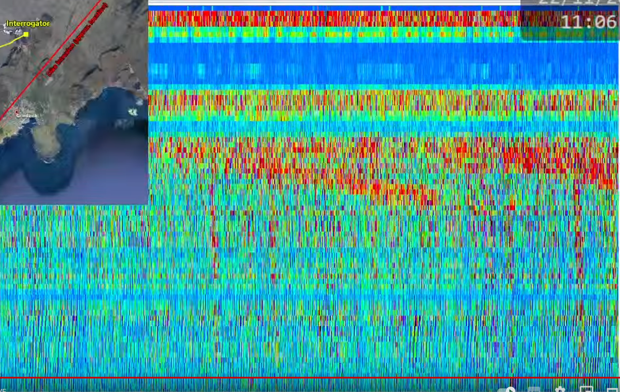
DAS-plot of the quake:
https://i.imgur.com/bBKve7J.jpeg
I saw that quake appear on the quake table and shows up as a large on on the Gridavik chart. I guess the size wont change much butI reckon the depth might as 1.1km is very shallow. Thanks for showing the DAS plot.
I think 1.1 is the default depth. It will be interesting to see the location.
The DAS signal was impressive. Is this likely to be an isolated pop? If it’s a response to increasing pressure from the continuing influx of magma from below (and/or sideways from east), my feeling is that it will be followed by more in the near future.
Any experts to comment/point out my ignorance?
Manually reviewed is 2.74Mlw at 0.1km
Wow! 0.1 is really shallow!
Perhaps, just perhaps, we may see an eruption soon, the quakes at the dyke have been getting a little shallower today but that one was a corker!
Or, perhaps, an uncorker?
I reckon that was probably the cork nearly out! Now just a bit of to and froing with the corkscrew.
M2.74 at 135m depth. Mechanism looks like a reverse fault. Very close to where the largest dyke deformation is centered.
https://www.youtube.com/watch?v=s7ffVhUgDEA
This is very unrested now…
Might be wind though.
Yesterday it was going wild with all the wind.
Unless it was something else but given how the cameras were shaking, and the MET mentioning that it makes smaller quakes detectable nearly impossible.
Now:
0.1 km
2.7
99.0
5.5 km WSW of Fagradalsfjall
50% quality.
Oops. 99.0% Quality
I believe IMO changes quality to 99.0% after manual review.
Things are looking really interesting right now. I think this might be it.
The larger quake was preceded by 2 or 3 weak tremor bursts, lasting a few minutes. Still continuing at a very weak level. 5.5 km NE of Grindavik, so in the safest zone. It is certainly trying to do a break out.
How do you recognize tremor with all this wind? Several times I thought there was tremor only to see that the live cams started shaking like crazy at the same time due to the wind.
You can’t really, I think. But wind is more constant, so you expect thicker and noisier traces over hours
Looking at this site would be a good start.
OOPs didn’t mean it to post in full.
I had a look at the zurich fibre sensor. The tremor shows up clearly in the most silent part of the trace.
Albert, what convinces you that harmonic tremor is in the middle area of the trace? 2 or 3 days ago some of us sat for hours carefully watching the trace, trying to figure out what it was telling us. I am curious, please explain more. Thank you.
Can really see the unrest following that larger quake of the odf highpass drumplot

That is certainly not wind related unless it is blowing hurricane force. 🙂
Alice, I am not sure what that is. It might be instrument interference. I have watched the Yellowstone site “is this on?” at https://isthisthingon.org/Yellowstone/daythumbs.php in the past carefully, and came to the conclusion that such waveforms as your post shows are most likely due to interference, not due to ground movement.
I’ve been thinking about the location of the 2.7 Albert. It is further east than most if the quakes. Could it be the edge of the graben dropping/extending?
I think something is up, not just the weather.
The Fagradalsfjall camera has been moved this morning:
https://livefromiceland.is/webcams/fagradalsfjall
looking north, up the valley instead of overlooking Grindavik.
The little white spot on the left appeared at 16:25, wasn’t there before.
Either fog or a patch of candyfloss.
We are all too nervous.
and your flashing photo is givving me a headache
That looks car sized I reckon.
Maybe snow, I guess. I think there was a shower just right before 16:25 (low visibility).
You know how it goes…
If it is significant, that will be obvious very quickly.
If it isn’t obvious, it isn’t an eruption.
I know you knew that already. Just saying for the benefit of any who are reading.
I don’t think so. First there will be smoke, then the big show (remember the cracks in Leilani?). This time we have good resolution cams that will pick up the smoke.
We haven’t seen anything like the cracks in Leilani in any of the three eruptions during 2021-2023. Just a big cloud of steam and gas, followed by fountains no more than a minute later.
Going by the last few years in Iceland…and I may be wrong… but if it follows that pattern we’d already be seeing orange, and grey smoke from moss fires, blackened ground etc.
@Tomas: Do have video material of the opening of any of the three events?
@Neil the caveat us, that there weren’t any nearby cameras at the start of Fagra I. We had to rely on the camera outside of Vogar, so we don’t know how the first event started.
I remember seeing video of the initial eruption of Fagra 2. I seem to remember some steam and smoke before the lava appeared. I cannot locate that video unfortunately.
@Quinauberon I can’t find it now, but for 2022 there was some really good footage of the start captured by one of the webcams.
https://drive.google.com/file/d/1PKzvTGMTr_Iln5VijqOosRj_SiyYNQlX/view?usp=sharing and go to the 1:00 minute mark, fissure eruption over to the left about 2/5 down from the top, look for white smoke at first.
I so agree Neil. However when looking at the Husafjall cam my heart always jumps as it pans back to the spot of bright lava. = AKA the greenhouse!
Every time I see the power plant….
@Tomas: Now its dark, so it doesn’t matter anyway. First thing we’ll see now is an orange glow, if we are lucky and see anything at all.
There’s video on yt of the opening minutes of Litli Hrutur.
I was watching the cams at the time. It went from a vague suggestion of smoke to a full blown fissure in less than 15 minutes.
It looks like the eruption started inside the greenhouse facility, and is fully contained.
Like it was drained through there, transported via pipe to the greenhouse to be used for power. The only consequence is that it is draining the dike, causing certain areas to drop by a meter or so…
Appreciate the humor, as we all need to keep a sense of it. My heart does go out to the Grindavik residents who face a very uncertain future, but I appreciate the Iceland government taking positive steps to insure that people are not dumped in the gutter (so to speak)
Top left…
https://livefromiceland.is/webcams/fagradalsfjall
It seems that we’ve some fire there. Optic illusion?
Definitely a very small light/glow there. It’s in the direction to Reykjavik. From Thorb we could see city lights before…
Extreme left margin? It’s a telco antenna. the flashing is too regular.
Definitely the glow in the sky is from Reykjavik and there is a large antenna on the outskirts of the city.
Not yet 🙂
As an aside – looking at the IMO update for today, at the end it mentions “dark hail”, is that a misstranslantion or a Iceland specific weather term? If the latter, what does it refer to? Graupel or freezing rain maybe?
dark hail = volcanic ash?
I think google translate has a premonition. 😉
“Fog and dark snow storms may complicate visual confirmation of an eruption in webcams.”
“Dimm él” means dense snowfall that obscures view like a fog would.
Many thanks Bjarki, excellent part mistranslation but part vernacular then – the English language version has:
“Fog and dark hail also affect the visual confirmation of the eruption with cameras”.
I was hoping it was a vernacular for a particular type of weather common in Iceland and nowhere else, as with the terms like haar and dreich in parts of the UK. “Dimm él” is another to add to the list.
It is an Icelandic specific concept because of the very short days here in the winter. Where one says “white out” conditions in English – at least in American English – the Icelandic words essentially mean “dark out” conditions. I can tell you that a blizzard in Iceland is very much a black out situation.
JB that must be really frightening! I was once walking across a field in Scotland in light snow. Then in a matter of seconds white out conditions descended. That was in daylight and very scary even though I knew all I had to do was reach a fence and walk round it back to the gate I had walked in. If that happened in open country all I could have done would be wait in place and hope it wasn’t long until the blizzard passed. For that to happen in darkness would be doubly disorientating
Many thanks JB, that makes perfect sense. Not something you would want to go walking in, let alone getting lost in!
Does those repeated patterns look like harmonic tremor to some of you?

I think the best people to ask may be the ones commenting on the Cambridge Volcanic Seismograph on Youtube. This one seems to be a pretty new piece of equipment.
Being one the people who help other people there, I would say that most of them, including me, don’t know much! XD
LOL. Me too then, I can clearly definte the quakes even very small ones but harmonic tremor is beyond me. I know Albert knows but he cant always be here to guide us.
In those noisy conditions the best we can have are educated guesses. Even IMO are saying that it’s almost impossible to conclude anything from today’s seismic activity due to the wind.
Eruption on Mount Etna (Sicily) creates the illusion of a Phoenix in the sky.
https://twitter.com/JamesLucasIT/status/1726668587287675210
That photo was taken by Davide Basile in 2019. The photo has since then been doing the rounds in social media with his watermark removed.
https://www.facebook.com/photo/?fbid=10219071428325711
Thanks, i didn’t know.
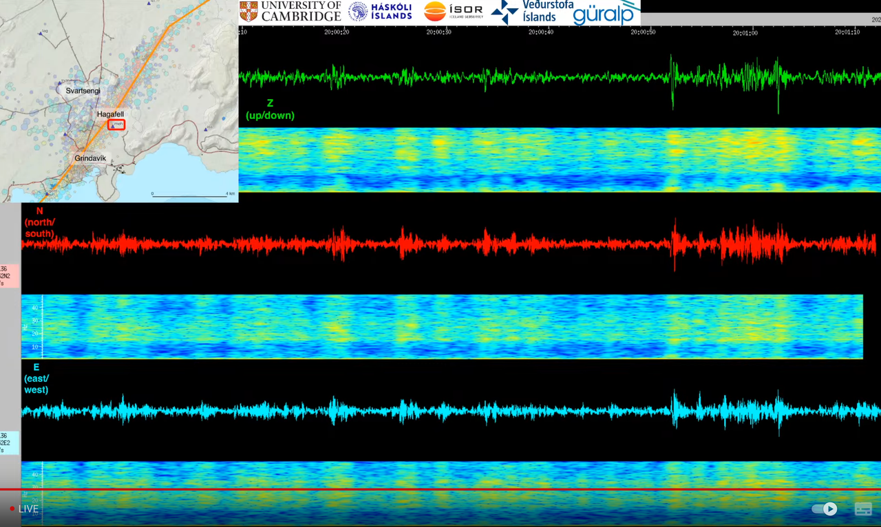
Is this it???
Wow this thing is noisy.
I think they turned it down a little as the small quakes looked huge and the quakes like the 2.7 looked like the world was ending. 🙂 🙂 🙂
Turn the red line back to 3:16 ish and then let it play. You will see the 2.7 quake just a little later and will see the unrest afterwards. I think there was some harmonic tremor after but I couldnt point it out to you nit being an expert.
Been very quiet since that quake. I think that was it’s first real run at breaching the surface. We’ll see another soon.
Yes with the quake being so very shallow I really thought we might see some action this evening, assuming the weather lets anyone see anything. I feel for those poor contractors out building the wall but I suppse mostly they are in cabs of lorries and diggers.
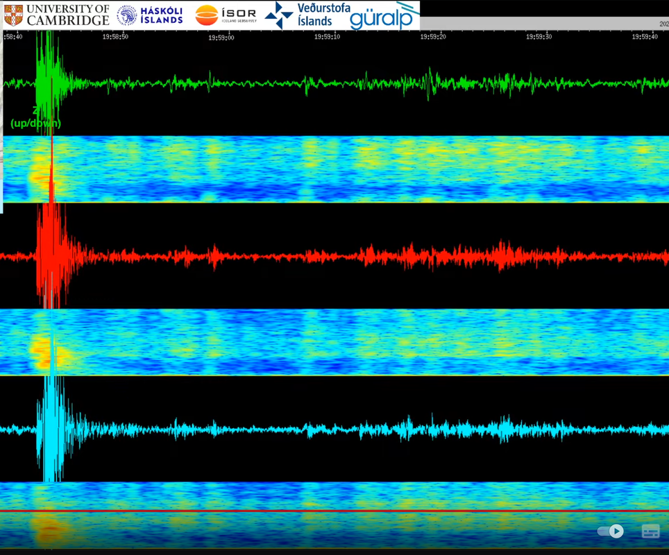
Are we not mostly looking at the low side of the spectrogram for harmonic tremors? I have no idea what to expect really…
The top one is up/down, then north/south and east/west.
I now have it playing on my TV. There is a frequency scale, which is I think what you meant. Bottom is 0 Hz, top 50 Hz. There is some low frequency tremor, but most is above 15Hz.
Is the construction equipment working today/now ? I think the geophones are close to the construction site
The construction equipment is working 24/7 and yet the quakes clearly show up so not really a major problem. The bad weather DOES obscure some of the minor quakes but as long as you can see the major players which I define as anything over 0.5 which do show up then I dont see a major problem personally.
Several times now that the Cambridge seismic station shows a small earthquake followed immediately by a prolonged sequence of noise / tremor. Might be just a coincidence, but it feels unlikely being how perfectly it aligns.
I also noticed that and I am totally guessing but it seems like rock cracking and the murmer of magma moving before it huts the next obstruction. I might be way out in that theory but it keeps me happy. 🙂
Why don’t you contact them and ask about this? Surely they notice that too, and probably have a scientific opinion on this. I would like to encourage you to do that. I am waiting on some replies of scientific organizations which I have contacted, and will post their response when it comes in.
East of Puhi for the 3.2, the 2.3 is south of Puhi.
2023-11-21 18:05:52
Earthquake
Magnitude:2.3M
Depth:0.6mi
2023-11-21 18:01:11
Earthquake
Magnitude:3.2M
Depth:-0.2mi
The RUV mosaic channel shows Sudnukhnur north as ‘Eldvorp’. The Sundunkhnur south cam pans north to south on the east side showing the exact same hill in the north.
It probably shouldn’t annoy as much as it does.
what is that???!?
https://livefromiceland.is/webcams/selvogur
Selvogur is at the very northwest tip of Iceland miles away from anything remotely volcanic by the way!*
*At least in the past 10 million years.
In a true Icelandic fashion, there is more than one Selvogur. This camera is at Selvogur on the south coast of the Reykjanes peninsula just east of Krýsuvík (see the red dot on map). Not sure in which direction it is pointing.
Classic Iceland
Looks like lights shining through water drops.
these cameras are encased in glass spheres and there is water on them or rain falling as the lighthouse runs around, lighting it up in this scary way
I was looking at a cam with the blue lagoon last night and I could have sworn it was on fire last night with huge flames reaching into the sky. Then reason kicked in and thinking logically about the rain on the camera lens I guessed it was the distortion from the raindrops. Which it clearly was as the blue lagoon buildings were still there today.
Your comment is very true. I had raindrops hit the camera lense, then give the impression that stupendous events were occurring. Later on I realized that I had made some rash conclusions which were not correct. The important thing is that we admit our mistakes but continue to push forward to understand what is really happening.
Just for your own information, the camera is located in the lighthouse at 63.8212375N, 21.6530097 W and 18 meters altitude.
This has just been picking up and won’t stop.
Said the same just above: several times now that the Cambridge seismic station shows what looks like a small earthquake followed immediately by a prolonged sequence of noise / tremor. Might be just a coincidence.
Tell me when it gets to 200 bpm and has a cardiac arrest
Can you locate the initial quake on the vafri.is map? It might give some hints.
I think most of what is showing up on there isn’t being picked up elsewhere. Either it is work on the wall interfering or it is too small to register.
There has been no work since last night. They stopped it due to the bad weather.
That rules that out then.
Detecting volcanic tremor is cutting edge work. I tried, and failed, although recently I was given access to the seismograph data. Scientists are very interested in this, regarding fissure eruptions, but we still cannot obtain enough accurate scientific data to move forward on modeling, and drawing conclusions. I appreciate the DAS work in this regard.
Probability of an eruption is slowly decreasing. Seismic activity has decreased, unclear how long it will take the sill near Svartsengi to fill up again. However, there is still movement in the shallow dike, including at Grindavík, we proceed with caution.
https://twitter.com/Icevolcanx/status/1727042917628530981
They don’t know what to think… just saying.
@Carl
I have heard them getting it well wrong before. So I keep my own council and wait. The influx of magma is not stopping in fact is at an increased rate over the last 2 days …. so yea, I wait and see, “It’s not over ’till the fat lady sings.”
Mark the time!
80 minutes later … 🙂
LOL
To be absolutely fair, he says that the chances of eruption are still significant but decreasing every day that passes without clear signs of magma movements. That’s probably the objective truth… but still, I have a feeling about tonight…
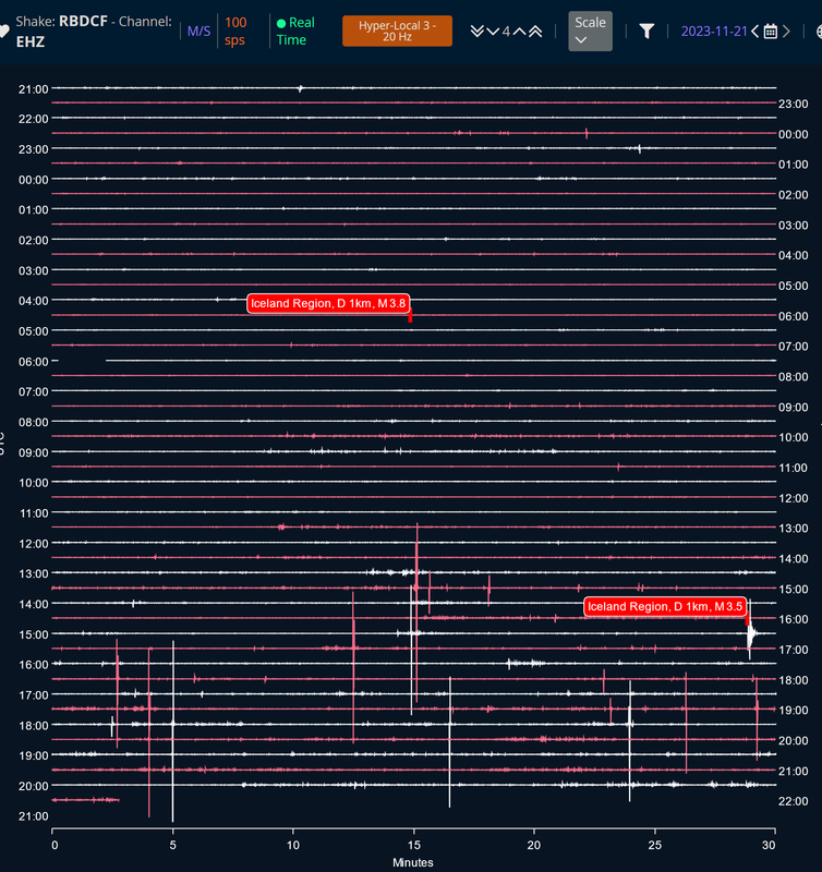
It’s difficult with the wind, but the drumplot for grv looks suspicious.
Yes, difficult. Thicker… thinner. thicker…thinner, Tremor or strong wind gusts?
I know that all of us are intensely interested in this, but nature is teaching us lessons. One thing which does stand out, is the recharge of magma, and subsequent ground surface elevation being read by the GPS stations in the Svartsengi/Grindavík region. See https://strokkur.raunvis.hi.is/gps/8h.html on this. Sooner or later, we will see a fissure eruption. The next week? Anyone’s guess. Next month? very likely. Next year, I will state my own opinion, yes.
I also think that the dyke might not reach the surface this time. Probability was high of course, but somehow it stalled.
Now we are seeing rapid inflation again at the spot where it all started, so chances are that pressure will increase again in the dyke (which will most lead to an eruption) or in a couple of weeks a new dyke will be formed.
For the people in Grindavik and the powerplant it’s not good news. The place will not be safe for a rather long time and a new dyke might cause widespread damage again,
Dirk, as the inflation is at a faster rate the last 2 days, what is to say that it isn’t also starting to flow in the dyke again? Do uou have any idea on that? The 2.7 quake today with possible period of harmonic tremor after would appear to suggest that to me but I am a total novice, well almost, so I seek wiser heads to confirm this.
I think that’s a good question… if there is really an influx of 75 m3/sec (I think that was the figure of last days), I’d expect more seismic activity due to increasing pressure.
The uplift/inflation at the original spot with a silent dyke is a bit strange.
Unless that silent dyke is silent because most of the rock breaking has been done?
It does have the advantage a lot of rock is already broken. The sill is still smaller than it was before it deflated at 1000 m^3/s so already fractured its dimensions, just needs to re-lift the roof. While the added volume for the dike is coming much slower than in the early part of its existence.
Dirk:
I agree with your asessment. The inhabitants of Grindavik are facing a very uncertain future, just as you said. What is a bit frustrating to me, is that back in the late 1940’s, people expanding the town were aware of big fissure cracks in the region, but went ahead anyway and built the town. Those cracks were nature’s way of saying “Please be aware, you’re building upon fissures and shifting ground and strike/slip faults”, but people have a funny way of building anyway despite the risks. We are just going to have to face up to the consequences of our choices and not grumble about it.
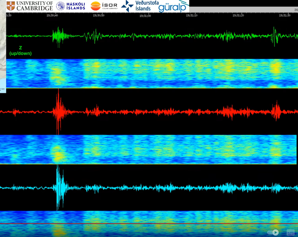
19:51.45, event occurred, highest intensity between 5 and 20 Hz.
Here’s another one:
… and it keeps going on like this:
Smaller quakes seem to be back since a couple hours .. although, I know, this is raw data .. could be the neighbour renovating?
Am I correct that volcanic harmonic tremore is between 1-12 Hz?
Sounds right to me.
yes, Alice and unfortunately these harmonic tremors frequencies are somewhat location specific. This means that we cannot establish a broad rule for ALL locations. The local behavior has to be carefully discerned.
I was looking at the Seismic Tremor charts just now and was bemused to read:
“Click on the red squares to see the Chaos Tombs.”
I think the earthquake pages have stopped updating. The main page has nothing after 18.35 and the skalfti 2.0 has nothing after 19.23, yet the drumplots show quakes since then.
I have noticed that before. It looks like little to no quakes and then thay all get updated in a rush. I hope that isn’t the case! I find it so frustrating when you know that possibly little to no quakes MIGHT lead to an eruption but you dont have clear data.
It is enough to turn the most level headed person into a conspiracy theorist.
Thankfully I am neither level headed nor a conspiracy theorist. Just a frustrated volcano lover.
Who would have thought that automatic translation will end meaningful conversation once and for all…
Meanwhile the moon is shining over Iceland. And we all feel that the decision is near. Either this is a divine hoax or Iceland’s meager earth will open tonight and …
Can I choose this option….. Iceland’s meager earth will open tonight….. Please!
The Chaos Tombs will open!
LOL. I suppose that is actually a very good description of an icelandic eruption.
Now I have a strong urge to look for a white bag of tools, but there’s to much light pollution.
“If I were to toss a pebble over this parapet it would be something like a bullet by the time it struck him. If I were to drop a hammer—even a small hammer—” (G.K.Chesterton, The Hammer of God)
Imagine a tool bag would have been dropped by a poor astronaut … Fortunately nothing like that did happen.
Is it just me or is the Melhóll Seismic Station showing a harmonic tremor? Just want to make sure if it is wind or not.
Grindavik had 17 m/s wind and 27 m/s gusts at 21:00, that should be enough to make some nice signal disturbance?
Been low level tremor all day in bursts. Just the magma bubbling about underneath with the occasional foray upward and/or a new batch arriving at terminal svartsengi gap. I keep thinking it’s building towards something bigger but it hasn’t. Strong winds don’t help as they might be making it look like constant tremor.
Just not enough pressure yet, I think we need to wait for an earthquake swarm/top-up event coupled with a bit of deflation at the sill to push it over the edge. Although I’d expect it to have another go at bursting through like it did at 15:28 at some point during the night.
Nothing but wind?
Ugh, pictures got lost, again:
https://www.ventusky.com/?p=60.6;-9.4;3&l=gust
Current wind gusts in Iceland.
Most likely wind.
I guess, if magma was at 800 meters deep on the 13-14th, that was 8 days ago. So if magma is rising continuously it us doing so less than 100 meters/day. I have never seen any data for the thickness of the dike so this is a wild guess, but 15 km long, 0.8 km deep, and 1 meter wide would give a volume of 12 million m3 to fill that last bit to the surface. Way too many variables to work from this alone but 12 million m3 a week is about 19 m3/s, rather under tge numbers posted. Mist likely the dike is wider than a meter and that above calculation also overestimates anyway as it implies an eruption to begin now, but this might also mean the sill is inflating while the dike is still being fed.
Perhaps the dike is following a path of weakness next to a previous dike, which is quite long, possibly 15km or more. Had the magma stayed in a localised area it would have erupted, but because it has spread along the length of this dike it has lost pressure. Therefore we may be waiting for several ‘top-up’ events from the sill before an actual eruption. If any of that theory is correct it means that the powers that be have underestimated this part of reykjanes and an eruption may well be very large for the local area. I hope I am wrong and it snaps before it grows any larger. Of course, not all of the dike will erupt regardless.
That is badically what I have been saying. Sundhnjukagigaroð is a very long fissure, all up it is something like 12 km, maybe as much as 20 if some outlying vents beyond the continuous line are from the same rifting event. Its not at all the same kind of volcano as Fagradalsfjall, which seems to do small fissures at a time which may eventually get pretty big but it is a gradual process. There is still a lot if magma at Fagradalsfjall so I think it is still active but might wait its turn until next year at least now.
I would disagree on how many intrusions are needed to result in an eruption though. This one nearly did it first time at full power, and is still in the cards. If the dike is cut off and the sills reinflate, a likely event, then this whole thing will repeat and there wont be a huge rift to fill this time. If an eruption fails now it will only return later and fully recharged… its written in the rocks, this place doesnt do slow.
Chad:
I basically agree with your reasoning, but the thing bugging me is this, how do we see recharge on the west side (as evidenced by the GPS readings) yet not too much has happened with the dike fissure which has been plotted and officially released”?
Is the dike channel from the sill been shut down?
With a steady influx of 75 m3/sec. or more (if the estimated numbers are correct), the thing will erupt sooner or later. But I also think is that the dyke might indeed be cut off from the sill, this would explain why we didn’t have an eruption yet and vanishing earthquake activity. Even if some of the pressure was released due to the long dyke and most of the rock cracking has been done, with such a high steady influx of magma, the dyke would most likely have erupted already.
I’m just wondering how the dyke was cut off … for me as a layman it sounds strange that 7 mio m3 of magma find an escape route from the sill, make a big intrusion and then the door is suddenly shut. Wouldn’t it be very likely that the incoming magma takes the same path and follows the first batch? Or does the backpressure of the filled dyke prevent it?
I suppose one other possibility is issue supply point is probably near middle of the sill. However the dike connects to the sill in on the eastern edge. Sill got squeezed out by the dozens of km^3 of rock on top of it at 1000m^3/second. That may well have made it impossible for magma to get to the dike until the sill reinflates. Not guaranteed to be same setup as rock will have adjusted meantime, but if dike isn’t getting resupply (think probably is getting *some*, still producing earthquakes even if slower), may well resume as sill reinflates.
Reykvolc that ispretty much exactly what I think ishappening. If the sill somehow erupted through its middle it could have had a long lived etuption. But to be honest I have not actually found any example of a sill melting a conduit in a basaltic volcano, conduits in those form from dikes that only form from sills by the edge of the sill rotating. Maybe exceptions do exist, and if the sills merge into a single magma chamber then that can form a conduit (Kilauea).
My mechanism is basically the same as how the Galapagos calderas work. Those are huge, but their magma chambers are basically gigantic sills. They erupt by having a sill move away and then rotate 90° into a dike. But in doing so also mean that the intrusion has to hold up the whole mountain to remain open, so they tend to stop fairly quick. The other consequence is that these eruptions are extremely intense and can be huge, Sierra Negra has had historical eruptions that were larger than Holuhraun and didnt require a gravity drain situation. And when it does do a gravity drain, well, lets just say Laki may not be so unique as it gas been claimed… Seriously that volcano is a monster.
Anyway, obviously here at Svartsengi the situation is a lot smaller but everything still applies. The sill deflated and was pinched off from the dike, but it has also now opened a rift and that will stay the preferred path, so the sill will reinflate and get forced into the rift again only this time there isnt anywhere to go but up…
Thanks for the explanations, Reykvolc and Chad. That makes sense. Put in a humorous way, the sill works like a toilet flushing mechanism. 😉
Probably a stupid thought but I was wondering whether any of the storm waves crashing onto the coast line around Grindavik will be being picked up by the various listening stations and adding to the noise and tremor. If so could tide times have a noticeable impact on timing and amplitude?!. I appreciate that wind is a different beast and will have a greater and more localised effect on each of the stations.. like I said probably a stupid thought…
The last IMO update said the wind will reduce sensitivity and waves will have an effect on low requency noise.
it does show up on the trace – I remember from last time there was something going on that storm waves made the traces hard to read
Current wind gusts in Iceland.
https://www.ventusky.com/?p=60.6;-9.4;3&l=gust
That is Very stormy. We had marginally worse in South of UK 4 weeks ago but we weren’t ‘listening’ for an eruption. There was one hell of a lot of noise from the wind gusts.
That is Very stormy. We had marginally worse in South of UK 4 weeks ago but we weren’t ‘listening’ for an eruption. There was one hell of a lot of noise from the wind gusts. Mind you, most of the wind was from a lot of trees close by something Iceland doesn’t have.
Not a stupid thought. Weather effects do register on seismographs, and wind is tricky to be able to discern as each seismometer location is unique and wind’s effects are different, so it’s not possible to just draw a broad brush on weather effects. Ocean waves also cause microseims, usually around the 1/7 hz band, but bad weather can up this frequency and introduce effects into the seismograph readings.
If you are hoping that we get a nice signal of harmonic tremor, signaling the fissure eruption, I believe this time things will not be so clear cut.
Waves do get picked by seismographs, obviously mainly those near the coast. Strong wind can hide almost any other type of signal and it seems to be predicted to remain very windy until Thursday. The very shallow earthquake though was not caused by wind! We will just have to wait for things to clear up.
the local AVO group told me they look for specific frequencies of volcanic tremor. They also said that i didn’t have enough knowledge to pick it out by myself. They also said they were happy that i was interested but to leave the official statements to the officials. They have been very nice, actually.
Speaking as a science educator (a professor in meteorology), I’m of two minds about this. Yes, leaving the official statements to the officials is generally a good idea. They have, after all, trained for this for many years. Similarly, it may be completely true that you “don’t have the knowledge to pick it out yourself”.
That being said, I would hope that someone would be willing to help explain it to you, and even if it wasn’t something that could be explained in a simple sound byte (almost certainly not), I would hope that they could have pointed you in the right direction to learn more.
From what you said about them “being very nice”, I do hope that means they did so, or were at least willing to.
Official statements can only come from officials. And sometimes data are needed that are not readily available on line. But in general, some other areas of science do better in working with interested outsiders. In my own field I have used results from non-professionals and co-authored with them
While it isn’t really possible to involve non-professionals on my field, collaboration with other disciplines works well. I always think if you can collaborate with scientists from another, field, there is greater progression, as they all think differently and approach problems from different angles.
Absolutely. I completely agree. Official statements should be left to officials, and not all data are easily available or in a form that lends itself to casual or amateur analysis (using “amateur” in a positive, not derogatory sense). To clarify my previous statement, I meant that I hoped that the AVO in this case was willing to try to explain how look for signs of tremor (or at least point mots in the right direction to learn more) rather than leaving at “you don’t have enough knowledge”.
Currently quake silence and rising tremor. I wonder what’s going on
Possibly the stormy weather masking the small quakes but even they dont seem to show up now.
That’s a really good point, but I’ve been studying the tremor plots for a couple of days and it’s my impression that tremor has been inching upwards. I could be wrong.
And one tiny quake just showed up! I am sure there were bigger ones than that on the drum plots, so what IS going on.
Tuesday
21.11.2023 22:01:29 63.874 -22.395 2.6 km 0.1 90.02 4.6 km NNE of Grindavík
IMO taking a well-earned break while it is comparatively quiet?
Tremor Grindavik shows that the purple graph is slowly increasing the whole day, while the blue graph has risen more steeply. Can we assume that the eruption will be today November 22nd?
No idea.
It took a tad longer for Geldingadalir.
Is there anyway that a roundtable discussion of Iceland volcanologists can occur? There is much uncertainty and I am sure that the average citizen reading the opinions is thinking “does anyone know anything?” I read a post of an Iceland person into this website, and his comments were ascerbic, but should not be discounted.
An outside person, geologist Shawn Willsey has been releasing videos of his personal opinion on current events, and the popularity of his videos indicates that people do want to be informed.
I’ve seen a couple of his videos and one of them promoted me to look lore into beachballs and focal mechanisms.
He admits he isn’t a volcanologist so there is a gap to be filled.
Richard, true. I have been pushing that we need to look at these beachballs and what they are saying. I still don’t have a 3d visualization of the movement vectors, but I know this would be very informative.
But I believe that already Professor Shawn Willsey has stepped up to the plate and performing a valuable public service.
That discussion DOES occur, constantly, Mostly asynchronously. Why would you imagine that it doesn’t?
I know that sharing occurs, I was hoping for some type of public roundtable discussion with a moderator asking questions.
That’s not really part of the scientific process – that discussion does happen, in meetings, at water coolers, but mostly online.
The process you describe sounds a lot more like a political debate than anything scientific.
It is happening every so often, problem is that it is mostly done in a village hall and in Icelandic.
Or a nice village bar in the sticks.
turn your attention to this camera
https://www.youtube.com/watch?app=desktop&v=BerZJunvSik
northern lights show 🙂
Thank you for pointing that out. That is the first time that I have seen them at normal speed and not speeded up.
Reykjanesviti webcam shows them very well. https://www.livefromiceland.is/webcams/reykjanesviti
But what idiot in the Icelandic government permitted that huge searchlight that sweeps around the city? Here’s a nation with a natural beauty in the skies, and they destroy it with that!
That could just be light beam from the lighthouse, which means it would be important for shipping.
A bit less critical in this GPS age, but still important.
GPS signal can be (and is) jammed, lighthouse beams less so.
As far as I can see, the beacon in the live stream is Reykjanes lighthouse at 63°48,94′N 22°42,26′W with the light characteristics (ljóseinkenni) Fl(2)W 30s. This means that the light is white, and there are two light pulses, with the whole thing repeating itself in every thirty seconds.
See page 10 (page 12 of the PDF document), in the start of “Vitar og leiðarljós” list:
https://www.lhg.is/media/sjomaelingar_islands/Vitaskra_150819_vefutg.pdf
As recent hubbub have shown, GPS signals can easily be distorted and you can get erroneous messages showing you are up to 5km away from your true position.
There is a lesson to be learnt, we need every single lighthouse back online to safeguard traffic against electronics warfare.
Can totally confirm this. GPS is … said to be super-accurate (eg within a meter or centimeters even) but this is only under perfect conditions and only available for the military.
The thing we see “Oh look, my mobile knows EXACTLY within a meter where I am” is just applied trickery. Constant measurements, the velocity of movement from gyroscopes, knowledge of topography and roads, triangulation from signal stations (including wifi) and the best guess becomes pretty accurate.
But leave the city, perhaps even walk through the woods, and you’ll be off by several hundred meters and more with the signal jumping around a lot.
I had to fight off a software project that relied on accurately locating people within 10 meters with little tolerance to deviation. I told the project lead this isn’t possible. He said, his iPad knows exactly. I told them the above. In the end, we had to make the project and of course downscale signifcantly because even in a big city and open place we got GPS accuracy of 50 meters in most situations.
Of course, we had no access to all the aforementioned trickery nor the budget to implement some of that.
Most phone “GPS” is not GPS, it is locationing between cell towers.
It is easy to disturb real GPS-signals, the satelite-signal is not strong, so a small transmitter can easily overpower it.
Just a warning for those in youtube chats. If you use the word “dyke” then Google seems to shadow ban you from chat for 24-48 hours. It doesn’t tell you you are banned and you still see your contributions appear but nobody will answer you as they don’t see them. If you spell it “dike” you won’t get banned. I have read several comments from people that it has happened to and I can also confirm it happened to me. Was shadow-banned from every youtube chat not just the one channel.
If you have spelled it that way before and didn’t get banned don’t try it again unless you are prepared to get barred for a period.
I recently posted that “dyke” is used in a very derogatory manner towards lesbians..at least in the U.S. and I assume elsewhere. That’s why it’s getting flagged.
For those who care about politically correct terminology, dike is the correct spelling in a geologic context …but I do recognize that there are other parts of the world where the two spellings are interchangeable…hence no offense intended.
From Collins English Dictionary.
dyke in British English
or dike (daɪk IPA Pronunciation Guide )
noun
1. an embankment constructed to prevent flooding, keep out the sea, etc
2. a ditch or watercourse
3. a bank made of earth excavated for and placed alongside a ditch
4. Scottish
a wall, esp a dry-stone wall
5. a barrier or obstruction
6. a vertical or near-vertical wall-like body of igneous rock intruded into cracks in older rock
Just because unpleasant people in the US use a perfectly acceptable English word in an unacceptable way does NOT prohibit me from using the perfectly acceptable English spelling Dyke .
I will NOT change the spelling I was taught at school because other people choose to take offence at it. It is more than clear that this word DYKE is being used in a perfectable acceptable way.
See number 6 of the definitions.
And Craig, you may not intend offence, [And please note the British spelling of what you spell as offense] but I am beginning to find your continued comments on this matter offensive. I heard you the first time and still choose to use my native spelling.
On the one hand, I think he is merely trying to explain why this might be happening, not that it is good or bad.
On the other, a huge part of me is right there with you. It’s a perfectly legitimate word for a natural phenomenon and the mere fact that the British English spelling happens to coincide with an ugly slur in American English shouldn’t get an automatic veto.
All this being said, I have cringed a bit inwardly whenever I use the word lately, regardless of the spelling, very much because of this connotation. I work in a context where the wrong word at the wrong time, despite the best intentions, can potentially land one in–shall we say–a less than desirable situation.
The problem is that you cannot reason with the algorithms. No right of appeal.
I just wanted to point out, that there is a quite successful Instagram account called @dykanite created by a Geology PhD student. I am not sure that the term itself will s derogatory in a general way, I think it depends on who uses it, and how that person feels about the subject.
https://instagram.com/dykanite?igshid=OGQ5ZDc2ODk2ZA==
Yes I’m fully aware of the derogatory term and I that’s why I try to use “dike” because of that but when I was taught in the UK it was “dyke” and I accidentally typed it that way. Bang – I was gone from all chats.
if people take offence at my English spelling then I prefer not to be on their chats.
It just shows the degree of ignorance of other peoples languages and dialects.
Their are very many common US words that the English people could take strong offence at but knowing they are using American English I would not take offence at it. I wish to be afforded the same degree of consideration I show to people from the US.
American english comes in part from outlying regions of England (e.g. ‘fall’ rather than autumn). Spelling comes in part from that famous American dictionary, Webster, which was littered with errors (such as aluminum). Nowadays, of course, spelling is mainly dictated by whatever microsoft can cope with.
And, since I can’t reply further to the thread above, I want to make it clear that I do *not* take offense at your spelling of this word.
…
So long as you don’t take offense that I spelled offense with an “s” 😉
It could be seen as offencive but no worries we won’t be offensed.
Nope, I never take offense at how anyone spells any word. Which may be why I got so irritated at anyone taking aoffence at my spelling of any word.
When I was at school I was top of the class for spelling, however as I have grown old and am having memory problems my own spelling has become atrocious with me at times using week when it should be weak and vice versa. I just have to accept that it will now be that way for good.
So I would never criticise others spelling especially as I know US and British English spelling of words can be quite widely divergent at times. I am acutely aware that US spelling will soon be the norm and that I am already from a minority in my spelling of English. However as I wont be around in 20 years time then it concerns me little.
I would also point out that me even being on here at this time is proof of ongoing severe insomnia that, even without me using white light screens, is relentless. I have had way too little sleep for the past 2 weeks so if I have offended anyone by my honest feelings then I am sorry and can only suggest my irritability is from a physical source and please to not be offended by me.
There was a time when you couldn’t get far on the internet if you were an Arsenal fan from Scunthorpe.
I am of the opinion that football should be banned due to the amount of violence, death and destruction that the fans cause.
It is sickening that we need hundreds of police officers guarding every single game and that you basically have to be scared walking around in the city every feckin’ match day.
It seems in the US the geologic term was changed from dyke to dike at some point decades ago. In a 1924 USGS report, I’ve noticed they use dyke. However in a 1964 paper, and I think all material since then at least, the term dike is always used for the magma intrusion.
Aha!
You have found proof that all US dikes after 1964 are manmade by DAARPA to cause an earthquake deathmatron weapon!
Disclaimer: This is a joke, and no pizza’s was hurt in the creation of the joke.
To correct a thing here.
A Dyke is a geoloogical phenomenon, and a Dike is a manmade object, that in turn should not to be confused with a Dijk that is a seawall.
And none of this should obviously be confused with the famous cold war agent Dick Dickman wearing his kevlar-shirt and kevlar-suit that was the reason that Stephanie Kwolek at DuPont invented the material in 1965.
Stephanie was used as part of the character Q in the Bond frenchise.
You might be cool, but you will never be Dick Dickman cool.
It can get quieter than it is presently, but it can’t get a lot quieter.
The tremor is rising, and I’d assume that it isn’t only the weather. The weather is like this the whole day, but two (blue + purple) graphes have significantly risen today. http://hraun.vedur.is/ja/englishweb/tremor.html
Blue=Wind
Purple=Waves
I think we are too much focused on an eruption on a single spot. A real – long – fissure eruption needs to be prepared well. If we look on the historical Svartsengi eruption of “Eldvarpahraun” – the REAL Eldvörp 😉 – the chain of craters of the Middle Ages fissure was very long. So it’s likely that fissures there tend to be long and to be built up. If Grindavik gets an eruption and lava like Eldvarpahraun, it will cover everything from the Golf Course until Hagafell including the Port and the Green house. The graben, that we talked about, may be the whole location of the fissure.
While the Middle Age Fires happened at Eldvörp some km west from Grindavik, the older prehistorical eruptions happend very much in the area of the current graben. They may show, what we can expect now: a Fissure on the western entrance of Grindavik; a fissure on Lagafell (SW of Thorbjörn tuya); a fissure from the Greenhouse through Hagafell towards NNE, which continues to NE until the slopes of Fagradalsfjall (Thrainsskjaldarshraun). The map layers of the prehistorical fissures and craters indicate that the fissures were longer than the fissures of Fagradalsfjall. So it’s a different development.
At Fagradalsfjall, it may be in the process of building a line of cones – one by one, in strict annual order. Perhaps Fagry vetoed the Thorbjorn eruption because there already was one this year – we will have to wait until January.
We’ve witnessed the creation of a new sill in the area. There is no central volcano that could play the role of Krafla’s central volcano during the Krafla Fires. Does the new created sill act like a central volcano during the coming Reykjanes Fires?
From HVO at 20:30:14 UTC
“There is currently no sign of an imminent eruption, but the increased seismicity around the summit and upper East Rift Zones are similar to events that have preceded other eruptions. The most likely location for renewed eruptive activity is within Kīlauea caldera, but it is also possible that an eruption could occur in the upper East Rift Zone. It is also possible that the seisimic activity observed today may subside and no eruption will occur. The onsets of previous summit eruptions have been marked by strong swarms of earthquakes caused by the emplacement of a dike 1-2 hours before eruptions and these have not been detected at this time. ”
Just an FYI
Macusn
Confused why they think a flank eruption would be more likely to occur in the upper ERZ when the whole SWRZ is lit up like a christmas tree… Everywhere I see the SWRZ being dismissed on the bounds of probability but the ERZ was non-eruptible for over a century before 1955…
I will also strongly contest a caldera eruption again this time, the summit has been primed to erupt now for weeks but hasnt, and the last eruption was brief and hardly removed pressure. Instead quakes are on the rift zones, amd inflation is much stronger there. Kilauea basically looks fully recovered from 2018, maybe not in volume but it isnt a resurgent caldera so cant fill up underground much.
I also took notice of that, have no idea what their line of thinking could possibly be. I mean there haven’t been these many SWRZ earthquakes since at least 1982. But when the UERZ gets a relatively normal level of earthquakes it’s going to erupt?
How active is the Koa’e fault system currently? https://ui.adsabs.harvard.edu/abs/2012AGUFM.V33B2862S/abstract
They can both cause upper SWRZ and ERZ eruptions. 1969 and 1973 were two small eruptions there.
Seems to be pretty lovely, probably more active than a typical year. But an eruption isnt likely there, it is higher elevation than the adjacent rift zones. So any lava erupting in the Koae would be associated with vents on one kf the rift zones, as was the case in 1973. There are some very tiny spatter vents from tbe early 19th century in the Koae, probably from 1840, although the upper stage of that eruption was only observed at a distance so this is my speculation.
The eruption in February 1969 (6 days) preceded Mauna Ulu that startet 24th May 1969. It was not very far from Mauna Ulu’s location. February was W of Alae Crater, while Mauna Ulu was towards E of Alae Crater.
Mauna Ulu was closer to the upper ERZ than Puu O’o. It looks like it better allowed both the Koa’e fault system, the summit and the SWRZ to do eruptions during the whole 1969-1974 period.
02/1969 eruption was over a wide area from south of Aloi crater all the way to the edge of Napau cater. It was a long fissure eruption that mostly went down the ERZ and trended east, there wasnt much to do with the Koae or any weird stuff going on there that year that I could find in records either. Mauna Ulu itself had more interaction, part if its fissure (the bit you can still walk around today) is continuous with a fault scarp, and shallow intrusions pushed west of Mauna Ulu a few times after spawning vents on its flanks and within Aloi, although more of the flank vents were on the east side.
The Koae Fault system is regularly intruded by dikes from both the SWRZ and the ERZ (dike intrusions originating from Hiiaka Crater travelled multiple kilometres into the Koae Fault System in December 1950, July 1963, and May 1973, and a major dike from Aloi Crater also made its way across most of the KFS in December 1965, not sure if there have been other instances). But these dikes generally do not erupt, or if they do it’s from the edges of this region. I looked into this problem and found the reason to be that summit overflows keep the Koae area relatively high in elevation, the dikes that intrude westward from the ERZ loose pressure as they grow are an unable to erupt in Koae high ground.
Are we going to get an active SWRZ period soon or is it still uncertain where Kilauea is going to go? 1969-1974 there was a period when both the upper ERZ and Mauna Ulu were active, when the Summit did eruptions and – during a pause of Mauna Ulu – 1972 SWRZ did an eruption. So there are times, when all upper systems are active: The Summit, the upper ERZ and SWRZ.
The SWRZ connector is beautifully visible on the Kilauea map right now:
https://www.usgs.gov/volcanoes/kilauea
There has been another surge of quakes now and both connectors are lit up with tiny orange and red curcles, so dense the black outlines almost obscure it all. Never seen that before outside an intrusion that erupts.
The swarm down next to the Kamakaia hills is getting stronger too. Those of us waiting to see lava might be on the wrong island… 🙂
The UERZ swarming could be a sign of overpressure, since, going from memory, similar seismic activity took place there before the 1974 and 1981 dikes. Today we might end up with 250 automatically located earthquakes. It’s probably going to do something soon, might be a non-eruptive dike though.
Even if it is a non-eruptive dike, the same thing we are seeing in Iceland will still apply, tjat dike will start a rifting event and probably erupt anyway even if it fails initially. By analogy, 1961 was a huge dike in the middle ERZ that only erupted a small amount, but kept reopening over the next decade.
1974-1975 intrusion didnt do this, but I suspect that was because magma flow into the ERZ was still ongoing and then increased greatly following tbe 1975 earthquake. The intrusion in 1981 might have been a last ditch attempt to fill that rift but then Pu’u O’o happened…
Unless those upper ERZ quakes are a sign of imminent change that way the situation now is that the SWRZ has the magma all to itself, and the magma supply now seems to be significantly higher than in 1974 too. Pele will do what she wants but I think she wants to take a trip to the desert personally 🙂
Well in the 1960-1975 period, practically every fissure swarm of Kilauea was intruded by dikes multiple times. Based on earthquakes and the location of the fissures September 1963, and probably October 1961, were dikes that started from the Napau area and followed the same path. March 1965, and October 1968 however were dikes that started from Makaopuhi, earthquakes and fissures happened there first, they simply converged with the path followed by the 1963 and 1961 dikes downrift.
I always looked at Makaopuhi and Napau (probably nowdays also the area below Pu’u O’o) as one fissure swarm, they arent offser from each other relative to the rifting axis like the other craters to the west are. They are like Bardarbunga and Hamarinn, or Grimsvotn and Thordarhyna, separate magma storage but on a single rift. Makaopuhi and Napau arent exactly their own volcanoes though but I would consider them to be satellite volcanoes of Kilauea, being able to behave a bit independantly.
The rift active from 1961 to 1968 I think went through both effectively. The same thing sort of repeated in slow motion after 1983, the initial rift that year started in Napau and went east, but in 1997 rifted further west as that years dike started from Makaopuhi. The 2011 dike and Kamoamoa eruption rifted from Makaopuhi all the way to Pu’u O’o, involving all 3 sources apparently.
I did notice the quakes furthest down the SWRZ seem to form a line, I wonder if it is the magma butting up against a fault and marking the limit of spreading movement, an analogue to the transform faults seen in ocean ridges perhaps. It does still seem to be magmatic anyway given it is adjacent to a number of vents but it does raise questions.
Anyone found a new Cambridge video-link?
https://www.youtube.com/live/s7ffVhUgDEA?si=yskMFVnJuIkuQxOc
If it goes down again you can just visit their channel and pick up the new stream from there.
Goes for some other channels as well, like RUV etc.
Yep. Navigate to the channel, there’s “tabs” and one of them reads “Live” which is where you’ll find the live streams quickly.
The video thumbnail needs to have the red label “LIVE” on it though, otherwise it’s a recording.
Thank you!
The inflation at Svartsengi seems to be tapering off. Maybe we won’t get an eruption after all.

Either it does it like Fagra I and erupts when everyone think it’s over …. or we just witnessed the formation of the magma chamber for the coming Reykjanes Fires.
The Reykjanes System has no central volcano that could drive the Fires. But the sill may act like a subterranean temporary central volcano for the next 30 years.
Or it’s reached a point where it is overflowing into the dyke again.
That’s the thought that crossed my mind, that or a new dike/sill extension.
If it is the current dike, then i assume we will see something happen pretty quickly.
The future of Grindavik must be a huge worry to the residents and the Icelandic Government. With this intrusion appearing to stall – possibly for weeks or more – I wonder what they will do with the town? The place is in a kind of suspension for now.
They’ve already said it will be months until they can return, and that is like a best-case scenario. Many will not want to return after this anyway.
I said on the last article that maybe an eruption is actually the best outcome, it removes any uncertainty, and makes it abundantly obvious that no one should live here. It means resources and money can be spent relocating the residents instead of trying to fix Grindavik, which would be expensive and has a high chance of being pointless anyway if the rift stays active and erupts in the future.
Pretty much, as soon as the dike went under Grindavik, it got put on borrowed time. Better to get out early.
If you want to check out the live streaming seismometer in the usual drumplot and tremor plot format, its three letter name is “meh” (short for Melhóll).
Thanks Tomas. I was trying to remember the codes of some the others last night. That is probablyvthe most likely one to show the relevant information at the moment though.
How independent is the current Grindavik Sill from Fagradalsfjall’s system? Is there a negative correlation (one steals the magma of the other) or is there rather no correlation?
If Fagradalsfjall continues on the path of the last three eruptions, the next will be after a break of 11 months in June 2024. But if the Grindavik intrusion and … possible eruptions interacts somehow with Fagradalsfjall, there the timetable would change. Personally I think that they’re independet and that after 8000 years of break Fagradalsfjall needs to catch up with the other systems. The shield volcano of Fagradalsfjall shows, what it can do over time.
It seems difficult to ascertain what is going on. Especially with the bad weather as of lately. Better now from what I see, we got it here in W-Norway over night.
I have an idea; The sill broke into the dike on nov. 10. It filled it – however full or partly is not known – but then eq’s gradually decreased in strength and numbers. There is no re-inflation at the ends of the dike from what I’ve seen. See Grindavik GPS last days. So.
What if we concider the sill into the dike as a T-connection filling the dike NE-SW. Very fast at start acc. to IMO. Then it gradually filled up and got pressurized but not enough to break vertically. Due to a hard upper layer of crust?
We might now be left with the sill re-inflating bc. the dike is full and holds (for now). The crust above the sill has had heat to soften over a far longer period (3 yrs. ?) and thus is more able to “give” than the newly formed dike. Would this explain what we have seen in In-SAR the last couple of days?
Kind of my garden-hose analogy from 10 days back, except now the “hose” bulges up (again) before the T. Because the dike is the “fresh hose” holding the pressure while the sill now has free space and already has expanded that space once. This could also explain the lack of EQ’s?
Just my thoughts on this. Do correct me if my reasoning is wrong.
But why did Festarfjall (FEFC) move upwards and to the south-east when the dike filled?
I am not an expert, but could it be partly due to the tectonic rifting? Several things have been at play simultainusly so this is probably 4D-Chess when trying to get a grip on it all…
That’s the deformation to expect around a dyke. Right above the dyke you get subsidence. In this case very obvious in form of a graben trying to eat Grindavik whole. This is because here the ground is being stretched out and loses its support from below. Away from the dyke the ground moves horizontally away (southeast in the case of Festarfjall) and up. The up-component is because here the ground below becomes compressed, so it bulges upwards.
Good explaination Tomas. On the subject I raise, what are your thoughts? I see signs of Thorjörn re-inflating on GPS. Grindavik GPS seems to have leveled out from the downwards movement observed since nov. 10. The same seems to be the case NE at Litla-Skogfell GPS. But it is too early to tell if it is a trend.
It’s a bit hard to tell what exactly is going on. The horizontal deformation keeps going, so the dyke is still expanding, although it seems to be gradually slowing down. Up/down is a bit tricky, because it depends a lot on the shape and depth of the dyke. They also claim that the sill is reinflating, and that might offset the deformation from what’s expected, but I still think it looks like the majority of the deformation is from the dyke. Maybe I’m making a mistake when thinking about the superposition of movements from the combination of a sill and dyke. The deformation is not entirely symmetric and larger movements are recorded to the west of the dyke.
Time will tell. If it doesn’t erupt now it probably will in a few months or years.
Comment to Tomas below;
I fear this is an unwanted scenario if the mechanism I describe is at work. Time will work against a (fairly) controlable scenario if there is a long period of buld-up going forward. IMO stated 1000 m3/s flow for a short period and above ground that is not what anyone would want. On top of that a prolonged waiting and uncertainty for the people of Grindavik.
So let’s just say the magma is not allowed to do that. “All in favor say ‘aye.”
Can Q make a device that opens the dike up safely in a safe location?
I think, there is a correlation, but not in magma stealing sense. Collapse of the Grindavik graben may increase magma pressure on the lateral sides.
This means something. Right??? 😀
They are doing a tap test. Basically someone, perhaps a PhD student, whacking a hammer into the ground at precise GPS locations to probe the response of the DAS system.
Prof: “Let’s do a tap test. Smack the hammer …”
Junior: “Okay”
Prof: “NOT ON THE COMPUTER!”
What we see at the moment is actually zoomed in sections of the plot.
Yes, it’s part of the tap test procedure. And while zoomed in, we can see that each line is actually not one meter as I thought, but 16m. The indexing is aligned with the length of the cable in meters, but there’s one line per 16 index values.
they said they had the array configured as 5000 effective channels . one channel = 1.6 meters , 10 channels = 16 meters, one line – 10 channels averaged(?)
I’d have got them to put rocks in their pockets and jump up and down.
Maybe a bit of both. From the description of the procedure: “This involves creating vibrations by either hammering or jumping near the cable”
They said in the chat they were jumping
Jump around…
https://youtu.be/XhzpxjuwZy0
https://twitter.com/Icevolcanx/status/1727305923142562127
Pumping equipment could cool lava and direct it away from settlements
It is under consideration to get powerful pumps to this country that could potentially be used to cool lava and direct it away from settlements and infrastructure.
The town is a port, so it is not exactly short of a water source to feed the pumps.
Would be spectacular to watch, assuming there is anything to see through the resulting vog.
They did it in Heimaey back in the seventies and it actually worked.
Ah ha! Many thanks, yes, in my head i was thinking that it had been done before, Heimaey is probably what i’m thinking of.
Yes, and they not only saved the harbour but improved it.
It’d be great if that were to be possible at Grindavík. Presumably they are thinking of pumping water from Svartsengi, but that’s hot so I wonder how the pumping equipment would cope. And if it’s from the sea, I’d have thought some big pumps and long, fat pipes would be required. And then there’s the question of the viscosity of the lava – Heimaey was pretty viscous, wasn’t it? But Icelanders are wonderfully resourceful and doubtless all this and more is being considered, so let’s hope…
The ship out past the harbor has a very large pumping capacity — or at least the one there initially did. The captain said that’s one of the reasons they were there.
Or dig a channel from the coast inland to shorten the distance for pipes and pumps? An army trench digger would possibly work, but depends on composition of the land surface.
Depends on the direction of flow and output, we must remeber that lava have incredibley low heat conductivity and because of that submarine lava flows are known to have flowed many 10 s of km as lobate pillow flows or sheet lava flows, the crust insulates lava very well against the cooling effect of water, so water may not cool a lava flow at all, just forming an insulating skinn where it can flow under that, submarine lava crusts are so good at insulating that imploded seafloor crusts often have lava stalagtites from their roofs, seen at submarine photos, suggesting that the ocean really does not cool a lava flow at all. Most of the Heimaey lavas flowed north into the ocean and not towards the town anyway, had the full force of the Heimeay lava flow been pushed towards the town, Im not soure at all that water attacks woud really work.
When pahoehoe lava flows invaded kalapana the residents hopelessly sprayed the crust with water, and with no effect at all on the lava flows because its so very insulating, Aa flows, while looking diffrent should be similar having an insulating capacrace on cooling
Indeed, flow direction and output will be key.
I assume they will be using huge pumps (the likes that would be used to try and quench fires in a refinery or gas storage facility) with the intent of creating berms out of the lava front. Not a case of stopping it, more to nudge it in a less destructive direction.
To do so i assume flooding the area ahead of it, along with dikes, would be necessary otherwise it will as you say form a crust and then potentially flow under that. Probably the most important consideration would be to pick the point on the landscape where it would be easiest to divert.
I dont think even liquid nitrogen even If used in huge ammounts woud do anything at all to a lava flow, the liquid nitrogen woud flow on top over an insulating gas layer due to the leiden frost effect, and lava is so insulating the cold wont get through in anyway, lava flows are well insulated, massive ammounts of stoored heat so pretty hard to attack
Ding! That’s exactly right… I work with liquid nitrogen almost every day, it would be totally useless against lava. I can’t even cool a bottle of hot water with it.
Earthquakes have fallen off a cliff. The entire intrusion has solidified and there will be no eruption.
Probably entirely sensible that people are still being allowed back in. Nothing to see here.
Whatever else may have happened, I doubt very much that the magma has solidified. Nor will it, for a very long time.
The temperature of the magma have dropped by around 10 degrees, so it is about 150 degrees above where it would solidify…
I was trying to preempt an eruption by saying everything is fine
via GIPHY
Andy – I think you’ve inadvertently caused a few heads to explode. with indignant rage. They will take even longer to cool down than yer average lava flow.
“The entire intrusion has solidified and there will be no eruption.”
You are completely wrong in your interpretation. This magma body will take DECADES at the least to completely cool.
Edited. Please ‘be nice’ – admin
This may also be a sign that pressure is in equilibrium.
Wait a couple more days. The sill is refilling. Whether it’s still connected with the dike or not shouldn’t matter much as the connection should still be a weak point and relatively easy to open back up.
This annoying storm should be peaking around now. It will calm down tonight and into tomorrow.
We should hopefully gey a clearer picture on seismic activity soon then.
There has just been a big update from this morning – quakes that weren’t added. Perhaps those in charge we’re having a well deserved bit of time off.
https://vafri.is/quake/
The activity has been the same, it is just that everything below M1 is not possible to pick up.
And without that any larger earthquakes look pretty naked. 🙂
So the little earthquakes are clothes then 🙂
The volcanologist who finds an eruption at Eldvörp more likely, did we ever get to know his reasoning why he thinks that way?
Perhaps it was 50/50: the dike formed at the eastern end of the intrusion, perhaps it was (and remains) equally likely to form at the western end.
I don’t remember seeing it. Quite frankly I’ve never been more confused because 10 different scientists say 10 different things. It’s gonna erupt, it’s not gonna erupt, it’s gonna erupt in a couple of weeks, it’s gonna erupt under the sea, under Grindavík, the dyke is going to expand to the north, it’s gonna blow up Eldvörp, blah blah blah. Nobody knows anything. Except Carl of course 😀 He has the most fun ideas.
Predictions are made in hindsight. Before that comes speculation
Here is Svartsengi (last measurement yesterday):
The ‘up’ seems to have stabilized but the data is not conclusive yet. I am wondering about the effect of yesterday’s earthquake. Grindavik is still rapidly moving SSE with no sign of slowing down. It has stopped sinking though.
Is slowing down for me. Is moving S about 7-9mm per day now, compared to 20-40mm in previous week.
The 4-hour plot shows no changes in the trend.
I didn’t plot the error margins that are given in the datafile from the “brunnur” server, so the apparent stabilization might be misleading.
https://twitter.com/Icevolcanx/status/1727390830703604097
Emergency level will go to Danger level at Grindavík starting at 11 am tomorrow: Residents get more extensive permissions
New information from IMO: probability of sudden eruption within Grindavík is decreasing every day and is currently considered small.
https://mbl.is/frettir/innlent/2023/11/22/fara_af_neydarstigi_ibuar_fa_rymri_heimildir/#Echobox=1700676104
Aviation Code back down to Yellow. Hopefully it won’t prove to be premature…
…so… “damp squib?”
Inflation under Svartsengi continues, it can be expected that the magma that is accumulating there can form
a dike again. Or into the existing one at Grindavik
or to the west of inflation area at Svartsengi.
There is still a possibility of a volcanic eruption in the area above the dike, most likely between Hagafell and Sýlingarfell.
https://twitter.com/Icevolcanx/status/1727396084224561220
I read this as:
Bah babababaahba-baa, BA BA BAAH Bah
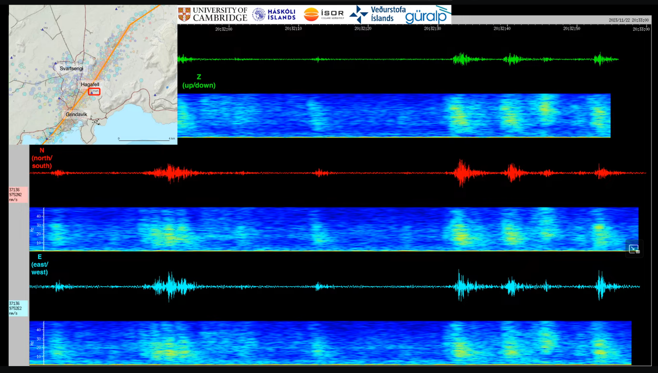
If that isn’t Star Wars … I think someone’s messing with us …
Whatever this is, I’m sure these are some nice beats.
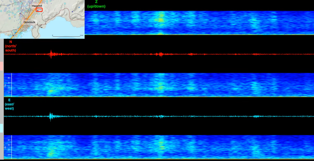
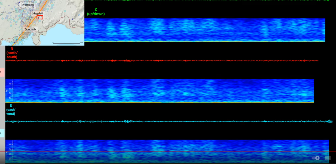
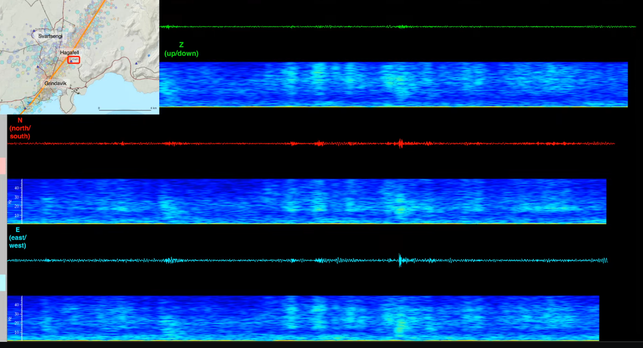
The answer, my friend, is blowin’ in the wind
The answer is blowin’ in the wind.
I don’t have my glasses on to see it properly, but it looks harmonic in terms of rhythm.