
(click on image for full resolution)
The expanse of water seems to go on forever. The Pacific ocean covers a third of the Earth surface, more than all the continents combined. The east-west width between Indonesia and Colombia is almost 20,000 km. There is 700 million cubic kilometer of water down there! 45 different countries own part of it. The averaged depth of their property is around 4 km, but it varies from the lowest point on Earth (10.9 km below sea level) to mountainous islands, including the second tallest island in the world, Hawaii. The first people who spread into the Pacific ocean from Asia found a paradise, but one with limited living space. There were islands dotted around in the west but they found far fewer of them as their reach expanded eastward. In the end, the lack of large islands stopped them from reaching the shores of South America: their story petered out at Easter Island. This ocean was never meant for humanity: this was shaped for the gods. Pele has her hideout here. She has a story to tell.
As befitting an ocean this side, it is quite a long story. You may want to make yourself comfortable, and get a coffee (or stronger), before immersing yourself. Oceans need space and time.
The Pacific ocean is the domain of the Pacific plate, the largest of the Earth’s tectonic divisions. But this is not the full story. The Pacific ocean is home to at least nine (!) plates, including five major plates (the Pacific, Antarctic, Nazca, Cocos and Juan De Fuca) and four microplates along the eastern boundary (the Rivera, Galapagos, Easter and Juan Fernandez). And there are further plates along the western side, such as the Philippine plate. The individual plates are separated by the usual arangement of spreading ridges, transform faults, and subduction faults. The Pacific ocean has them all. Major subduction trenches exist on all sides except the border with Australia. The main spreading centre is in the southeast of the ocean; older ones have gone extinct. On balance, the Pacific ocean is losing size because of subduction outweighs spreading. The volume is reducing by about 2 km3 per year. At this rate, it will last another 350 million years. Still, if your Monopoly version contains the Pacific ocean, I suggest you buy. It should be a safe investment.

The numerous islands dotting the ocean suggests that volcanic activity is common, at least on the western side. Take away the water, and the topography indeed shows this. There are sea mounts (submarine volcanoes) everywhere. Typically, a subducting oceanic plate should be passive: the volcanoes which feed on the subduction zone are located a hundred kilometer or more on the other side, on a different plate. The subduction tranches which surround the Pacific are themselves surrounded by the famous ring of fire, which should leave the Pacific as a haven of tranquility within the turmoil of the surrounding continents. But the multitude of volcanoes within the ocean basin shows that the Pacific ocean is far from pacified. It is restless, with many breaks and faults in the oceanic crust providing pathways for heat and magma. There are volcanic stories to tell. The largest flood basalt known on Earth is on the floor of the Pacific: the Ontong Java Plateau, which erupted 120 million years go. Some of the islands and sea mounts are arranged in long chains, such as the Hawaiian–Emperor chain and the Louisville ridge. They show the impact of local hot spots continuously drilling holes through a moving crust. There are few other places on Earth where volcanoes can last for 100 million years.
The struggle for survival
Oceanic crust is very different from continental crust. The continents are made of low density rock, formed by melting basalt and letting the lightest stuff rise up and solidify. Because of the lower density, the continents float on the denser mantle below; not even the weight of a glacial icecap can push them back into the mantle. Continental crust lasts forever; some is almost 4 billion years old, and many places are underplated by crust 1 billion year old or more. Continents are indeligible blemishes on the surface of the Earth.

Oceanic plates are very different. Their crust is created at mid-oceanic spreading centers, with magma that comes directly from the mantle. There is no separation between dense and light rock: the magma composition is the same as that of the mantle, dark and dense basalt. But if it is the same composition, the density must be the same, so why does it sit atop of the mantle? What stops ocean crust from sinking? In a way, it does sink. Oceanic plates lie much deeper than continental plates – they don’t float well because they are too dense. The oceans above them are a consequence of this: water unerringly aims for the lowest point. That still begs the question why oceanic plates sit above rather than within the mantle. The reason is heat. The oceanic crust comes up as hot magma, and is warmer than much of the mantle. Because of the residual heat, oceanic crust is typically about 10% less dense than the underlying mantle, and so it floats, albeit reluctantly and not nearly as well as the continents.
Let’s put some numbers on this. The continental plates are about 20 per cent less dense than the mantle. For a thickness of 40 km (this is typical for continental crust), their surfaces should sit approximately 8 kilometers above the surrounding mantle. Oceanic plates are about 10 per cent less dense than the mantle below, and are about 10 kilometer thick. So they sit about 1 kilometer high. Therefore, the ocean floor should be about 7 kilometers lower than the continents. This is roughly correct: the deep ocean is about 6 kilometer deep, and continents sit typically 500 meter above sea level. This leaves 32 kilometers of continental crust unaccounted for. This forms a keel: it sticks out the other way, into the mantle. If you want to make your continent higher, you have to make it thicker. Indeed, mountain ranges sit on very thick crust. (Alternatively, you can also use heat. A hot spot underneath a continent will typically push up the land by 1-2 kilometers.)
But much of the ocean is less deep than 6 kilometers. Why? The reason is excess heat. The spreading centers sit very high (typically 2 kilometer below sea level): they have the lowest density because their heat is fresh and their crust young. As the oceanic crust moves away from the centre it ages and cools: it becomes a bit denser, and therefore sinks a bit. The ocean floor grows deeper as it moves away from the spreading centre. After 100 million years, it has cooled enough to reach the standard 6 kilometer depth. The depth of an ocean tells you a lot about its age.

And it tells you that the Pacific ocean is ancient. A cut through it shows that apart from the seamounts and volcanic islands, much of it is the standard 6 kilometers deep. The crust here must be at least 100 million years of age.
But after 100 million years, the density has increased to the point where the survival of the oceanic crust becomes marginal. It is now close to beginning to descend and subduct. Oceanic plates can only survive for so long. Unlike the continents, oceanic plates have short lives and they die young. 200 million years is about the limit, and many start to subduct earlier. As long as there is a spreading center, the subducted crust will be continuously replaced and the plate can survive. But without a spreading center, the oceanic plate would soon disappear altogether.
So how could the Pacific ocean possibly survive for another 350 million years? A single plate can’t. The only way is by having one (or more) spreading centres, and that means at least two plates, one on either side of the spreading center. If there are more plates, only those bordered by active spreading will survive. The others will disappear. The current situation, where much of the Pacific ocean is governed by a single plate, is neither stable nor healthy. The ocean is going downhill.
The Pacific story
How old is the Pacific ocean? It is older than you may think: the water has been here for a very long time. When Gondwana existed, there was no Atlantic ocean or Indian ocean (there was however an equatorial ocean called the Tethys, partly bisecting Gondwana). But all around Gondwana was an ocean, known as Panthalassa. This was the Pacific at the peak of its powers. And the Pacific ocean is older still. It formed during the break-up of the previous super continent, called Rodinia. This takes us back almost a billion years. The Pacific ocean is as ancient as the continents!
How can this be? There must have been a continuous process of crust replacement, which compensated any loss of the older crust into subduction zones. Whole plates must have gone down into the abyss. We indeed have evidence for several lost plates of the Pacific. The Farallon, Phoenix, Izanagi, and Kula plates have all disappeared, and there will have been others. And new plates have formed. The Pacific plate itself, despite its current domination of the ocean basin, wasn’t always there. It is less than 200 million years old, making the ocean itself four times older than the current plate. The Pacific has seen many changes. Subduction zones have consumed entire plates, with their remnants ending up below the surrounding continents, or sometimes underneath the Pacific ocean itself. New plates formed to replace the fallen, and new subduction zones formed but not always in a similar place. New spreading centres came into existence, wherever the pull from subduction split an existing plate. These spreading centres could jump to new locations, but eventually would go extinct. And sometimes a hot spot would come and cause havoc, creating volcanic islands or flood basalts, and perhaps tearing the crust. It is all part of the game. The process was always driven by the physics of aging. All oceanic crust needs recycling and replacing. The ever changing plates and plate boundaries are just the way that the Earth makes this happen.
How do we know?

The ocean floor carries the imprint of its history. But it can be difficult to read! The oldest history is regularly erased: nothing older than 200 million years survives the subduction. A subducted plate can still be recognized in the mantle, as a region where seismic waves travel faster. During subduction events, parts of the oceanic plate may end up attached to the continent and avoid being taken dow. That is most common with volcanic arcs, and both sides of the northern Pacific ocean contain remnants of these.
But this is not enough to satisfy curious scientists. They want to know how plates have moved, how fast, and where from. How do you measure this? Again, the answer its at the bottom of the ocean. Its history has left scars which tell us what happened. Among those scars, the volcanic island chains are the easiest to recognize.
The chains tend to have one volcanically active island at one end. This is assumed to be the position of a hotspot which drives the activity. If the hot spot is stationary, the string of islands is formed by movement of the plate.
The Hawaiian-Emperor chain is the prime example. Currently, the hot spot is powering the island of Hawaii. The islands and seamounts behind this becomes progressively older the further they are away from Hawaii. When each island was formed, it was at the location where the island of Hawaii is now. The chain points into the direction the plate is moving. There is a bend in the chain: about 46 million years ago, the direction suddenly changed and became much more northerly. This shows a general re-organization of the plates of the Pacific. It can be more difficult to know whether the plate itself changed its motion, or that the hot spot moved to a different plate. The chain also records how the activity of the hot spot waxed and waned, which is an interesting bonus.
The second piece of the puzzle comes from the magnetic field. When the crust solidifies, at the core of a spreading center, the iron in the solidifying lava orients itself to align with the Earth’s magnetic field. Once solid, the iron cannot change it orientation: there is now a magnetic field frozen into the ocean floor. The direction will always show where the Earth’s magnetic field was pointing at the time and place the crust formed. The Earth’s magnetic field sometimes reverses its direction. The ocean floor remembers this: you can see stripes of opposite directions of the magnetic field, divided by the reversal events. Counting the number of reversals from the currently active spreading centre gives the approximate age of each segment of the ocean floor. It is a powerful method. There are over 50 reversals known over the past 150 million years. They are randomly distributed: sometimes they are less than a million years apart, but at other times the separation can be many times more. The accuracy of the dating therefore varies, but in general it is very good. The stripes show which way the ocean floor is moving, and so in which direction the spreading center was located. The magnetic field also remembers the angle that the field made with the ocean floor, and this measures the latitude. By measuring this angle you can know how the plate has moved in latitude, at least with respect to the magnetic pole.
The magnetic field does not record the longitude. For that, you need to use the nearest hot spot and island chain. Hot spots should be tied to the mantle below, independent of the crust. This provides a stationary reference frame. Spreading centers, in contrast, are not stationary. Even when active, they move with their plates, and they can even be subducted (when this happens within an ocean they will have gone extinct well before; a recently active, warm spreading center can however be overridden by a continent).
But the assumption that all hot spots are stationary is no longer accepted. There is growing evidence that hot spots do not keep exactly the same position with respect to each other. Some models now use a frame of reference that is fixed to Africa, as it appears that Africa has been moving very little: it is our most stable continent. Going back more than 80 million years, Africa was attached to bits of Gondwana and at this time things become more uncertain.
Dating the Pacific

As a well-behaved example, the figure (from Seton et al.) shows the magnetism pattern in the eastern Pacific. Some reversals are labeled – note that the same label may occur in several places. Near the coast the reversals have lower numbers which means the crust here is younger. The direction towards younger crust points at the responsible spreading center. In this case, the oceanic crust appears to have come from underneath the North American continent. That is not possible, and it means that the original spreading center has been overridden by the continent. On the other side of that spreading center was a different plate, called the Farallon plate. The subduction zone that pulled it all in was on the far side of Farallon. Farallon was one of the major plates of the Pacific ocean. Nothing is left of it. Even Ozymandias left us more. Still, science is not easily defeated, and ancient magnetism has revealed to us its past existence, how and when it died, and what is was doing just before the end. Even the speed of its demise has been recorded.
In the north, below Alaska, the labeled lines run in a very different direction. This sudden bend in direction, from an angle of 161 degrees to one of 279 degrees, has been recognized since the 1960’s. It is called the ‘Great Magnetic Bight’ (it is ‘Great’ because it is in the US). Clearly, the western regions were attached to a different spreading center, which was located far north. It too has been lost in subduction. On the far side of this different spreading center must have been yet a different plate. It is known as the Kula plate, and it is the second of the Pacific’s ancient building blocks, dating back to when the ocean was called Panthalassa. Again, nothing is left. Only the sea remains. To quote the poet Percy Shelley:
I met a traveller from an antique land
Who said: “Two vast and trunkless legs of stone
Stand in the desert. Near them, on the sand,
Half sunk, a shattered visage lies, whose frown,
And wrinkled lip, and sneer of cold command,
Tell that its sculptor well those passions read
Which yet survive, stamped on these lifeless things,
The hand that mocked them, and the heart that fed:
And on the pedestal these words appear:
‘My name is Ozymandias, king of kings;
Look on my works, ye Mighty, and despair!’
Nothing beside remains. Round the decay
Of that colossal wreck, boundless and bare
The lone and level sands stretch far away.

The patterns in the western Pacific are even more complex. The young Phillipine plate has a clear spreading center. To the east, the patterns visible on the Pacific plate point at a spreading center between the green areas labelled ‘SR’ and ‘MPM’. (Green indicates remnants of old flood basalts.) This spreading center is in fact visible on the map of the Pacific, running from the Aleutia-Kamchatka corner towards the southeast, across much of the Pacific. It is notable how old the magnetic stripes here are. Magnetic reversals younger than about 80 million years have numbers; older than 120 million years have ‘M’ numbers , starting with M0. (There are no reversals known in the 40 million years in between.) The stripes here have ‘M’ numbers. The spreading center on the Pacific plate went extinct around ‘M10’ which is 130 million years ago.
Further to the east, the magnetic stripes point at a different spreading center which now lies underneath Asia. The plate on the other side was the third of the major plates of Panthalassa. It is called Izanagi. Originally, the mid-Pacific extinct spreading center separated Izanagi from the Pacific plate. When it went extinct, the combined area was claimed by the Pacific plate. Elsewhere, the precise locations of the borders between Izanagi, Kula and Farallon are not known because of the erasure by subduction. But it is amazing how much we do know about these plates which made up an ancient ocean, but which now have all gone down into the mantle.
South of ‘MPM’ there is another sudden change in direction of the magnetic stripes, even more extreme than the one near Alaska. This one has no name but it surely deserves the name ‘Greater’. It points at another spreading centre located in the South Pacific.
Sometimes the lines do not line up very well. This is what makes the pattern confused. The cause is spreading center instabilities. The center is not intrinsically tied to a specific position on either the plate or the mantle: it is just the place where the outward pull makes the plate break. At times a spreading centre jumps to a new location. Such an event happened in the central Pacific, where it jumped northward by as much as 800 km. Another complication is evident just east of Japan where the ‘M10’ and ‘M14’ lines cross. This suggest that around 135 million years ago the plate boundary in this area changed. This was approximately when the central spreading center went extinct, a time of upheaval in the Pacific. It appears that the Izagani plate also rotated a bit over time with respect to the Pacific plate.
In the above figures, Hawaii is located just to the right of the words ‘Pacific, on the stripe labelled ‘34’: this magnetic stripe covers a very large age range, between 83 and 120 million year. The ocean floor around Hawaii is 100 times older than the island itself.
The southeast Pacific is much simpler. The pattern shows a spreading centre to the east of the Pacific plate, which still exists and is still active. In contrast, the southwest Pacific is an utter mess. The green areas are the Ontong Java, Manihiki and Hikurangi Plateaus: they are all the same flood basalt eruption, later divided by spreading right through the center of the flood basalt plateau. The plateau formed about 120 million years ago. South of this spreading center was the Phoenix plate. The complexity of the patterns suggest there were several microplates as well. When the spreading stopped, the Phoenix plate became part of the Pacific plate; spreading restarted at the edge of the Antarctic plate, far to the south.


An ocean in motion
The Pacific ocean was given that name because it seemed peaceful to the first European explorers. The Polynesians would have known better. Now we know that the history of the Pacific is far from peaceful. It is a destroyer, an eater of plates, an ocean of ruthless competition. If Darwin had known, the theory of evolution would have looked quite different. This is no route towards improvement of the species. Survival is just a matter of luck of location, and the struggle is of old against young – with the latter the invariable winners. Oceanic plates have a ‘best before’ date written on them in magnetic ink.
Can we depict how this battle played out underneath the peace of the Pacific? Various reconstructions have been attempted over the years. The main uncertainties are in knowing where the plate boundaries were. Microplates, such as have formed along the coast of North America, can easily be missed in the reconstructions.
Before the Pacific plate existed, 200 million years ago, the main plates were the Izanagi, Farallon and Phoenix. They met in the middle, in a triple junction, and all three boundaries were spreading centers. We have no data regarding this as the crust around the triple junction has now disappeared underneath Asia. The Pacific plate formed from a disturbance near this triple point. By 150 million years ago, there was a new triple point between the Pacific, the Farallon, and the Izanagi plates. The spreading center between the Pacific and Izanagi plates remained active for 100 million years. Spreading between the Pacific and Farallon plates continued until very recently. By this time the Farallon plate had broken into pieces. The Kula plate split off 80 million years ago, later followed by the now lost Vancouver plate (at 48 million years), the Juan De Fuca , Cocos, and Nazca plates. The Great Magnetic Bight traces the location of the Kula-Farallon-Pacific triple point.

The image here illustrates how the East Pacific has evolved. It is taken from Seton et al. The frames are centred on the US. The colours show the different plates. The growth of the Pacific plate (green) is clear, as is the break-up and subsequence disappearance of the Farallon plate. There are differences between the main models, for instance in how long the various spreading centers remained active. But the overall picture is generally accepted.

The picture above shows how the origin of the Pacific plate is envisaged. It begins with a bifurcation of the speading center between the Farallon and the Izanagi plates, just above the junction with the Phoenix plate. The two arms separate out, and the enclosed area becomes the new plate. Because it is surrounded by spreading centers, the fragment begins to grow.

40 million years later, the new Pacific plate has grown into a decent size and is expanding northward. From here on, it will push the other plates into their graves.
Shatsky Rise
The floor of the Pacific ocean contains several remnants of flood basalt eruptions. The biggest one is the Ontong Java Plateau. In the north, there is one: the Shatsky Rise, located towards Japan. This also is huge and is one of the largest volcanic eruptions known on Earth. It contains three separate structures of which the southwestern one is the largest. The total volume is 4 million km3. It fills 0.5% of the volume of the Pacific ocean. This eruption will by itself have raised global sea levels by 10 meters. It clearly formed by an enormous emplacement of magma, some of which erupted on the ocean floor and the remainder contributed to the bulge. The Shatsky rise is dated to 144 million years ago.

The Shatsky Rise. Named lines show the magnetic reversals. Image from Li et al.
The magnetism around the rise (see the left panel) show how the ocean floor here has spread. On three sides, the clear striping of a spreading center can be seen. On the south side, the pattern is perpendicular and more confused. Look harder, and you recognize the pattern of a triple point. Three faults, delineating plate boundaries, came together; all three acted as spreading centers. At one time, this was the beating heart of the Pacific ocean.
Triple points were already mentioned above. They are fairly common: wherever there are more than two plates, a triple point should be around somewhere. In practice, almost all triple points are under the sea. Currently, only the Afar triple junction is on land. Each of the three plate boundaries that meet at a triple point can be different: some are a spreading centre (termed R for ridge), some have a subduction trench (T) and some are just transform faults (T). The Shatsky rise was of type RRR, i.e. all three arms were spreading centers where new ocean crust formed. RRR is a stable configuration (not all possible combinations are, and some (esp. TTT) are physically impossible). The three faults are traditionally at angles of 120 degrees but such perfect symmetry is pretty rare in real life.
Most triple points are fairly passive but some are associated with a break in an existing plate. When a hot spot pushes up a large bulge in the crust, the crust can crack in the traditional triple-armed way, at 120 degree angles; the cracks can extend outward and grow into new plate boundaries. Where once there was one plate, now there are three. And by the nature of hot spots, all three arms initially become spreading centres. This can also happen on continental plates, for instance the Afar triple point broke up the Africa-Arabia plate 30 million years ago. Most hot spots don’t do this: the Yellowstone or Hawaii hot spots, for instance, have not broken up their native plates. But the Shatsky hot spot may have come close.

From Li et al. SR stands for Shatsky Rise, OJP is the Ontong Java Plateau
The Shatsky rise has been suggested as being responsible for the formation or growth of the Pacific plate. In the former case, it would have erupted near the Phoenix plate, two of the three arms would connect to it and thus separate out the triangle that was to become the Pacific plate. If the Pacific plate formed as early as 190 million years ago, than the Shatsky rise is clearly too young for this. The second option has the Shatsky Rise erupting at or near an already existing Izanagi-Farallon-Pacific triple point, invigorating it and causing a rapid enlargement of the young Pacific plate northward.
The Shatsky rise is located on the Pacific plate. But part of it will have erupted on the Farallon plate. This part has been subducted underneath North America and is no longer available to any submarine volcanologists.
Hawaii
Hawaii is the famous example of a hot spot trail. The island chain forms a perfect recording of 80 million years of history. It raises some questions: why the sudden bend, 45 million years ago, and where and how did the hot spot originate?

Regarding the first question, a plate can change direction from a re-organization of neighbouring plates. A spreading centre may form (or go extinct), or subduction may start somewhere. It is not entirely clear what happened in the Pacific ocean but many suggestions have been made. It may have been externally driven: this was about the time that India crashed into Asia. More likely, it was a change within the Pacific basin. The most plausible suggestion is that this happened just after the spreading center between the Pacific and Izanagi plates had subducted, and Izanagi was no more. This caused the Pacific plate to move more to the northwest, no longer restrained by the Izanagi plate.
But where did the hot spot come from? It was always near its current position. Don’t try to extend the path and look for the origin in the Bering Sea: the hot spot has never been there, and it was never on that plate. Some of the magnetic data suggests that some of the islands formed a bit further north than Hawaii is now. The Hawaiian hot spot appears able to move a bit. The linear chain shows that any hot spot jitter was much less than the plate movement which took the islands away to northwest and north, into the abyss of subduction.
There is however an interesting coincidence. The chain points directly at the sharp corner between the Aleutian arc and Kamchatka. The age of the islands (or rather, sea mounts, as they have long since eroded to below sea level) at the northern end of the chain is about the same as that of the sea floor in this location, 85 million years. (The age of the sea floor is a bit more uncertain because it coincides with the long delay between two reversals, but it is between 80 and 120 million years, and given the distance to the older reversal, will be closer to the former.) That places the Hawaii hot spot of that time very close to the spreading center. In fact this is visible: the map at the top of this post shows the extinct spreading center which bisects the Pacific, which 100 million years ago separated the Izanagi and Pacific plates. Around this time, it failed. The Emperor chain seems to come from the end point of this now-extinct spreading center. A bit over 80 million years ago, the Hawaiian hot spot was close to or on the spreading center.
Spreading centers have a tendency to be attracted by hot spots (see Iceland where it follows the hot spot against the direction of plate motion, which has caused a considerable detour of the mid-Atlantic rift). So it is is plausible that 85 million years ago, Hawaii was on the spreading center. Between which plates? On one side was the young Pacific plate. On the other side, it was close to the border between the Izanagi and Farallon plates. But this was also the time that the Farallon plate began to break up, and a spreading center developed between the new Kula and the Pacific plate. The Hawaiian hot spot was close to this point, and was there at the right time. Perhaps this wasn’t a coincidence? Perhaps Hawaii was, at the time, actually the triple point between the Izanagi, Kula and Pacific plates? Perhaps it initiated the first break-up of the Farallon plate by triggering the new east-west spreading center.
We have mentioned how hot spots do not normally break up plates. But some do. The Afar hot spot broke up Africa, the most stable of continents. The Shatsky rise occurred near a triple point and may have caused it to migrate. Nowadays, the Hawaiian hot spot is content with drilling holes through the Pacific plate. But in the past, perhaps it did break up its predecessor, formed three rifting arms and separated off the new-born Kula plate. Perhaps Kula was born of Pele.
This still leaves the origin of the Hawaiian hot spot unclear. Did it form on the spreading center? That seems plausible, given the coincidence of position. After all, most of the world’s hot spots seem to be attached to current or past spreading centers. The map below shows the locations of the 50 or so hot spots. Almost all are in the oceans. Flood basalt eruptions, in contrast can be either on land or in the oceans.

A hot spot model
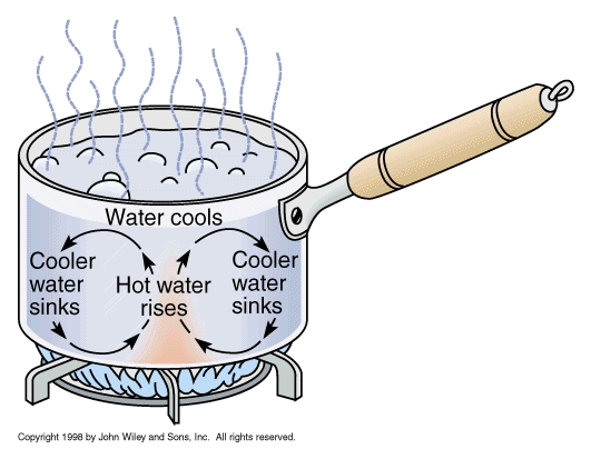
How does a hot spot work? You can see this in the example of a pot of boiling water (a wide pot works best): water comes up, moves sideways, cools down, and goes down again, in a continuous cycle. For this to work, you need a temperature difference between the top and bottom. Turn off the heat, or put a lid on the pot, and the convection disappears. Similarly, a hot spot shows where hot mantle material rises up, in a convective plume. There are two types of hot spots. The first is initiated by heat low in the mantle, and is deep. The second is driven at the top and is shallower. Once they are established, it is hard to see much difference, but they differ in how they begin.
A stable convection pattern needs bottom heat, a way to remove this heat from the material at the top, and a way to move the risen material away so it can descend without interfering with the rising plume. All this happens in a pot of boiling water.
How does this work in a spreading center? The pull from the distant subduction zone causes a tear in the crust. This reduces the pressure, and allows mantle material to rise up. In the process, it partly melts due to decompression. The new crust is pulled away (this is the spreading part) allowing new material to come up. It is the standard way a spreading center works. However, it is not yet a hot spot. Now envisage a triple point. It is like a spreading center, but it is a point rather than a line, and it expands in three directions. It is more efficient than a spreading center. It can be the beginning of a hot spot.
To turn it into stable convection, we need to get rid of the heat and material at the top. The heat is easy. First, the decompression melt takes away some heat, and second, the liquid magma erupts at the surface where it cools efficiently. The material that is brought up needs to be moved sideways, but the spreading of the plate will do this. So now we have a hot spot which is becoming a stable feature.
Once the roots of the rising column reach well into the mantle, the system becomes tied to the mantle rather than the crust. The crust, spreading center and triple point are all moving with respect to the mantle. The new hot spot therefore tries to move away from the triple point. For a while the triple point or spreading center may follow it but eventually the distance becomes too large. But the basic mechanisms that keep the convection stable continue to operate. The volcano on top carries off the heat, and the moving plate carries off the mass (including the volcano!) allowing the descending material to be situated well away from the rising plume. Now we have a stable structure, no longer tied to a spreading center.
This model explains why hot spots prefer triple points: that is where they form. It explains why hot spots can move around a bit with respect to each other: the main action is at the top, so they are not as strongly tied to the mantle as one driven by deep heat would be. It explains why hot spots are in the oceans: that is where spreading centers are normally found, because spreading centers create oceanic crust which lies deep. It may even explain the poor survival of hot spots under continents: continental crust insulates too well, so the heat may not carried off fast enough; this can stop the convective plume. It does not explain everything. Sometimes hot spots do create triple points, as in Afar, rather than wait for one to form: this is best explained by a spot initiated by excess heat deep down in the mantle. Hot spots do impact continents, as for instance in the Siberia and the Deccan traps. But it seems to fit Hawaii. This model can explain why Hawaii is where it is, in the middle of the Pacific ocean. It may even explain Iceland. And with this speculative model I’ll end Pele’s story.
Hawaii is so much more than a paradise with a volcanic temper. It may be born from events in Panthalassa, and it may have helped shaped the ocean it sits in. There are secrets in its past, and skeletons are hidden in its oceanic cupboard. Ozymandias fooled the poet. The missing mighty works were hidden below the sand where the poet failed to look. Pele has gone one better. She shows us wonders on her island, which make us forget to look for treasure below the surface. Was Pele created by the Pacific, and did she, in return, destroy one of her plates? It fits her reputation. What a story it would be.
Albert Zijlstra, August 2018

Further reading: The dancing Earth
Sources
M. Seton et al, Earth Science Reviews, Vol 113, pp 212-270 (2012): Global continental and ocean basin reconstructions since 200 Ma
Sanzhong Li et al., Geological Journal, Vol. 51, pp 562–578 (2016): Orientation of joints and arrangement of solid inclusions in fibrous veins in the Shatsky Rise, NW Pacific
Alan Smith, International Geology Review, Vol. 45. pp 287-302 (2003): The Origin and Distribution of Cretaceous to Recent Intraplate Volcanism in the Pacific Basin,


Haven’t read the New Post about the Pacific yet but i’m going to enjoy it… can tell by scrolling thu it … can’t wait to pose a question on the lavacam.org….. anyone else think the glow down low could be a small breakout??? now off to enjoy Albert’s post… Best!motsfo
Wow! Great collection of info, Albert! and ps…. don’t miss the approaching bands of the typhoon/hurricane in the live cams in Hawaii…. Best!motsfo
Those bands can be problematic. Each one is in essence, a mini storm front fully capable of spinning up a tornado/waterspout. The issue here in Florida is that these fast spin up tornados track in a completely different direction that one’s from normal storm fronts, so you have to keep track of any alerts from all directions. On the plus side, they don’t have time to become monsterous in size… but an up close EF1 will ruin your day just as well as the huge EF4s and 5s of Kansas / Oklahoma.
Haven’t read it all, but the mention of the lowest point on earth reminded me of a fun fact. You are closer to the center of the planet when you are standing on the South Pole 2,835 m above sea level, than you are when you are at the bottom of the Challenger Deep.
Maybe the reason Hawaii hasn’t fractured the plate is because it is right in the middle of it, and so it would have to tear the entire plate in half to break it. The hawaii hotspot is probably the most powerful mantle plume on earth right now, and from the looks of things, about 80 million years ago there were large islands like now and this is when you theorized it could have broken the plates. Currently the feed of magma to the big island is exceptionally high compared to the long term average, and may have started really increasing some point in the last 2 million years but especially since mauna loa and kilauea have formed about 800,000 years ago, which is why about 0.2 km3 of magma feeds into the volcanoes every year (95% to kilauea currently). This is similar to the situation 80 million years ago except without any plate boundaries. If it was closer to a plate boundary then it would likely have fractured the plate like you said, or formed a temperate version of Iceland.
So the Hawaiian Hotspot 85 Million years ago, may have been a “Iceland’? Very Cool! Now, the other question I have… is the Hotspot still moving? Will it make it to land at some point? Or is it pretty stable, right there, there in the middle of the Pacific?
Hi, Jory…. just a funny thought of mine: Hawaii is already “to land”, it’s sitting on land at the bottom of the ocean. i remember as a young child, people generally thought the ocean was just a great abyss…. didn’t know the mountains were everywhere. i’m OLD… 😉 Best!motsfo
and futher… i realize i see the land as stable and the ocean as filling in the low spots… probably comes from experiencing the huge tides we have here in Alaska… 30 feet and more sometimes. i see water as the breath of the earth…. it flows in and out, the land remains.
The dominant driver of plate motion is subduction. (Slab pull). Whether the Hawaii hotspot makes landfall depends on the relative motion imparted by the various subduction zones.
Nothing to support this, but the hotspot that carved the snake river plain is essentially what that would look like if it happened… but there is some evidence that it directly formed under the Eastern Washington/Oregon area.
I read somewhere years ago that the Rockies’ basement is what blocked/slowed the remnants of the Farralon and that the melting of those remnants in one place is what is powering the hotspot. It also is supposed to explain why Yellowstone has not moved much in the last 3Myrs (relative to its previous 10Myrs).
…Or something like that; I may be remembering it wrong.
Another Stellar article addressing one of the more difficult topics to relate in plate tectonics.
I particularly like the hotspot formation scenario presented here. It makes a sound alternative to the antipodal hotspot idea. I always had an issue with the high number of impacts that idea needed to account for the hotspots.
Related to the article in some ways. Open in separate window
Looks like an xkcd graphic. Those are awsome!
LOVE IT!
ca 2000m – at this depth if you shoot a hole in a pressurised scuba tank, water will rush in rather than air rush out! Outstanding!
Makes you realise what an incredibly small slice of the Earths biosphere is suitable for human life.
Here’s USGS photos of side by side of lava flow thermal data. Photos from Dane DuPont’s post.
https://www.facebook.com/photo.php?fbid=199195277616288&set=pcb.1057845967714554&type=3&theater
Also Dane Dupont on Hawaii Tracker, posted NASA photos of the Mauna Loa fire is getting bigger. Hopefully, it won’t be just winds, but rain to help put it out.
https://www.facebook.com/photo.php?fbid=199195167616299&set=pcb.1057845967714554&type=3&theater
I don’t know… It’s the Pacific so it gets weird. Around here, the weather after a tropical system passes is flipping beautiful nearly every time. Drier, clear, and aside from debris dust, and odd bugs from God knows where, absolutely fresh and clean.
And occasionally, you get strange plants/weeds growing in your yard afterwards.
The restart of the Mauna Loa inflation has become nicely visible. It began mid July, about when Kilauea resumed its deflation. Which may or may not be related!
Its probably a direct cause, that scale is in changes of a few mm, so not much.
But, a trend is a trend, and that one seems to be indicative of a real signal even through the noise.
on recent overflight with Mick and Bruce, John P. Lockwood ,( one of the world’s leading volcanologists. He is currently President of Geohazards Consultants International, Inc) has said that Mauna Loa inflates when Kilueau deflates but it is understood that the two have different origins. He said the volcanologists in charge should be aware of Mauna Loa now… ((taken from Hot Seat Hawaii this morning) Best!motsfo
article by Lockwood…
http://www.volcanologist.com/
That link goes to an article about the June 27 flow, and it looks like the website hasn’t been updated since then.
On mauna loa though, I have a theory that in Hawaii the volcano that is fed magma at a low rate (currently mauna loa) is subject to deformation caused by its more active neighbor. This can be seen where mauna loa had a small eruption in 1975 during a time when kilauea had a major (although short lived) draining associated with that years earthquake, and then several years later as kilauea was rapidly becoming more active there was the start of an eruption on mauna loa that was much bigger. Likewise in 1868 and a few points in the late 19th century kilauea became much more active than usual it was often associated with activity at mauna loa, which was dominant of the hotspot during that time. The amount of magma mauna loa has accumulated since 1984 is comparable to the amount of lava erupted during the recent eruption in puna, so it probably can’t hold off much longer and a rapid inflation of kilauea could push it beyond that point. Very rapid and vigorous rebound after deep collapses is a notable but poorly recorded characteristic of kilauea, it happened in the 1500s, in 1790, 1823, and on a smaller scale it happened in 1960 too. So things could get very interesting in Hawaii over the next few years, and in both volcanoes putting it off for longer makes it progressively worse in the end… I guess this is what happens when things don’t change for 30 years then have to make up for it all at once.
i knew it wasn’t current… just wanted to support that he had some knowledgeable background… i might have found something more current but i’m too lazy… 🙂 Best!motsfo
Albert, that is such a huge and exceptionally educational article. I am amazed you can write and know so much! I have read only the first part, but now I understand the tectonics you explained so clearly.
You are so gifted at explaining things! I’m jealous.
Thank you for your generosity, both in time and ability to inform!
The cool bit about it is that I think this may tie into a future article he’s been kicking around in the back channel. It might take a while though, a lot of rumination is going into it. I’m trying to argue a connection, but may fail if the evidence doesn’t support it. Albert makes the final call about that since I will blissfully ponder along on little evidence. VC deserves higher standards than some random wild arsed idea that I come up with.
😀 😀
Hahahahaha… made me laugh out loud… had to tell Hubby why. Best!motsfo
4
Nice trick; x = 4 but the upper vertex is far away than the base and the observer is aligned with the vertical side. and so, this one seems to be shorter than the base.
It’s certainly not 4, as the line on the bottom is obviously more than 3 and it isn’t a right angle since the line at the bottom isn’t square with the line on the left.
No, obviously the triangle is not actually flat on to us but shown in foreshortened perspective. The upper point is farther away than the bottom two. That’s why the left side seems short. 🙂
Sounds intriguing. How are the back channel ruminations going?
Willie Nelsons annual concerts used to be know as the West Texas brain fry”.
I think thats what we have going on right now. I’ve got at least two separate arguments going on there, each one is in opposition to the other, and Albert is the referee.
I’m still tweaking my own crazy theory too. At least the main parts of mine, so far (needs much more analysis), seem to be pointing generally the same direction.
I spent a few of hours revisiting navigational calculations in Excel in order to run a DR track on a hotspot and Albert ran across a paper that used the same method with better track integrity and other supporting data. (In my opinion.)
The cool bit about it all is that no matter how ding-bat my ideas are, they will get looked at for their own merit and deservedly tossed on the trash heap if they are too weird.
Synchronicity is a concept, first introduced by analytical psychologist Carl Jung, which holds that events are “meaningful coincidences” if they occur with no causal relationship yet seem to be meaningfully related.
In 1886 Mount Tarawera went nuts. The popular Pink and White terraces along the shore of Lake Rotomahana were destroyed. Though it was years before the concept of statistical black swans… take a look at something that Lake Rotomahana is famous for.
And harking back to a previous article…“The pink appearance over the mid and upper basins (near the colour of a rainbow trout) was due to antimony and arsenic sulfides, although the Pink Terrace also contained gold in ore-grade concentrations”
Notice the arsenic part of that. Arsenic facilitates the dissolving of gold and enables deposition of gold by hydro-thermal fluids. Yet another example of mineralization.
“[Rex] Bunn and Dr Sascha Nolden believe the terraces were not destroyed or pushed to the bottom of the lake, as earlier research suggested, but were buried on the foreshore of the lake.”
Forensic cartography with Hochstetter’s 1859 Pink and White Terraces survey: Te Otukapuarangi and Te Tarata Bunn-Nolden (2017)
Those scheming black swans! They are the real NWO! xD
I have honestly never seen a white swan before, all our swans are black too…
Sun burn
They cancelled Tropical Storm Warning for Hawaii. I’m concerned about the winds with no rain during these wild fires. Both Hawaii & California too, really need it to help put out those fires.
http://www.staradvertiser.com/2018/08/08/weather-updates/hector-passing-south-of-hawaii-island-as-it-tracks-westward/
Brian Hughes, a fireman from Hilo, Hawaii, went to California recently to help in fighting the wildfires. He died recently while battling the fire when a tree fell on him.
http://www.hawaiinewsnow.com/story/38762352/hilo-native-california-firefighter-dies-in-massive-wildfire
Trees are vicious… especially when spooked or under duress. Condolences to the family.
Fire damaged trees are really scary. They fall silently without warning and they are highly unpredictable. They also remain a hazard long after the fires have been put out. Respect to all the men and women fighting these fires.
Big aftershock in Lombok: M6.2. I haven’t seen any reports about damages.
The RIMS seismograph has suddenly gone completely quiet again, after a few minor eartquakes.
It looks like a lot of them went quiet around the same time.
Great piece, Albert. Definitely for me, the more I learn the more I realize how little I know.
https://www.facebook.com/ikaika.marzo/videos/1927477787304748/
There is still a lot of lava flowing into the ocean, considering the eruption has essentially stopped for 3 days now.
Also apparently pu’u 8 is glowing more than before, though there were no pictures. Considering the vent still has a lava pond in it after a few days it is quite possible there will be a few fountaining episodes in the future, although if it is like 1980s pu’u o’o these could be weeks apart.
I dont think it will be a slow outflow like the 61g flow before, its probably too far from the summit for that so it might just build pressure until it can suddenly push up through the vent, or possibly through uprift fissures or even pu’u o’o again (although that is less likely). This would be very destructive as these lava flows will cover new areas due to the old channel being blocked, and this includes to the south over the ridge, as well as parts further north. It will be interesting how this plays out.
OT..Off to get Hubby to his bi-yearly checkup in Homer…. gorgeous bay…. might stay a couple of days… might not be back for a while… one time while making this run a big black bear ran into my car… hit the side going full speed… i was going 55mph… Hubby asked if the bear was all right… i told him i wasn’t going back to find out. Anyway… everybody be good…. no biting. Best!motsfo
He probably was, it was a glancing blow and bears are pretty tough. I’m thinking the only real hazard (to the bear) would have been a broken neck due to the tangential force imparted by the vehicle. If it survived that, it likely shook it off and sprinted into the brush.
In your case, not stopping was probably the safest move. A stunned bear is not to be trifled with, even if it was just a black bear. Though they have a less dire reputation than a brown bear, they are still quite capable of doing massive damage/injury. Dunno for sure, but I think the black bear won’t chase you as far. Grizzly (Brown bear) don’t give up as easily.
I do know that ursids are close cousins of canids, and I’ve seen dogs survive some amazing stuff. You would not be that far off the mark to think of a bear as being a ruggidized dog chassis. A dog is optimized for long distance pursuit… a bear is optimized to slug it out.
Which is interesting. When in shape, a human fits the bill as a pursuit predator like a dog. While we can’t sprint for miles, we can trot along for great distances, wearing out what we are chasing. This similar mode of hunting is probably one of the reasons that dogs came in handy when they became domesticated. I’ve even seen some arguments that we didn’t domesticate dogs, they taught us how to manage herds and become pastoralists. The fact that humans and dogs have strong familial social interaction traits made us compatible under the right circumstances.
And yes, I love my dogs. Like their ancestors, they alert me to dangers, and I keep them fed. (This was most evident when I found that lady laying in my front yard. The dogs are who alerted me to her presence. Caution told me to keep my distance from her.) → So, I just called the Sheriff’s dept. {it was one of those “hair on the back of your neck stand” up situations.}
Ok, stupid bear joke. If you’re being chased by a bear, how can you tell if it’s a black bear or a grizzly?
Climb the nearest tree you can get to. If it climbs up after you, it’s a black bear. If it knocks the tree over, it’s a grizzly.
I’ll get my coat…
Actually your joke might be a fairly accurate description of the situation…
Plume seen at Puʻu ʻŌʻō shortly after M 4.4 – 22km SSW of Leilani Estates, Hawaii
2018-08-09 16:50:32 UTC 19.370°N 155.029°W 8.4 km depth
From Facebook https://www.facebook.com/ikaika.marzo/posts/1927613087291218
Tyler Mannison Plume coming out of Pu’u O’o.
Christine Epp
3 hrs
Pu’u oo as of 15 minutes ago
It’s ALIVE!…
Well, maybe. Could have been a rock-fall. But from the photos, it seems a bit more persistent than a dust cloud.
USGS just posted this as part of their daily summary –> “Middle East Rift Zone
Gas measurements of the Puʻu ʻŌʻō plume taken on August 6 and 7 indicated a reduced SO2 emission rate lower than the August 3 measurement and similar to what has been observed over the past three months. No active lava was observed in the crater on an overflight on August 6th. This morning, the steam plume appears wispy and intermittent.
A magnitude-4.4 earthquake occurred southeast of Puʻu ʻŌʻō this morning at 6:50 a.m. The earthquake had no significant effect on the status of Kīlauea activity except to generate a brief dust plume from Puʻu ʻŌʻō several minutes later.”
Some interesting gas bubble research regarding Kilauea: http://www.spacedaily.com/reports/Size_matters_if_you_are_a_bubble_of_volcanic_gas_999.html
Forget Kileauea-it’s ,it’s YellowstoneEEEE!!
From the Express (surprised it isn’t the Daily fail..)
https://www.express.co.uk/news/world/1000808/Yellowstone-volcano-eruption-super-volcano-eruption-big-one-earthquake-USGS
Tectonic quakes, period…
The volume of the big island of Hawaii is about 200,000 km3. The big island started forming around 1 million years ago. In the last 1 million years there has been just over 1000 km3 erupted at yellowstone. Basically since Hawai’i started forming it could do a VEI 8 every 20,000 years in theory, at least 20 times higher than the global average, and at its current supply rate kilauea could do it in only 6000 years…
Yellowstone is basically the equivalent of that person who did something epic once and lives off it forever, while never actually doing it again… In the past 3 days kilauea has erupted more lava than Yellowstone has in the last 50,000 years… Effusive volcanoes leave their explosive counterparts in their own dust. Daily fail need to find something else to scare everyone with.
I have no idea how much lava has been erupted in Iceland in the last million years but it could be somewhere close to 1 million km3 which is bona fide flood basalt territory.
Exactly.
Yellowstone is basically just a normal volcano that has decided to erupt all of its volume in one go instead of slowly over time to build a mountain.
Hawaii is probably even big enough to classify as a small flood basalt but it erupts constantly so it has ‘normal’ sized eruptions (usually)
That is why kilauea is my favorite volcano 😉
Yellowstone would definitely be a massively large geologic “hold my beer” event, however, most of it’s eruption would be made up of heavy stuff that would settle out fairly quickly. The immediate area would obviously be pretty busted up for a while, but the earth, as a whole, seems quite adept at sorting out large but short-term bumps like Yellowstone relatively quickly and getting back to normal programming.
I agree. Kilauea and Hawaii volcanoes in general are and have been in an entirely different league over the past million years or so.
A league unto itself… Impressive at one time, not so much anymore.
Yeah, we all run across a guy like this. Highly skilled star athlete. Back when he was 17.
The bit that seemed strange is that the calculation to get an eruption due date right now always included the eruption 1.3 million years ago which was not a VEI 8. It was very big but several Holocene volcanoes have been in that size range so it’s not an unusual event really. The last eruption was a VEI 8 but the one before that wasn’t until over 2 million years ago and could be classified as a different volcano. Even if it isn’t, 3000 km3 is not really exceptional for any volcano over that sort of timescale, most average stratovolcanoes could probably get that big easily if they stay active that long. Then you have Hawaii where 10,000+ km3 in <0.5 million years is a bare minimum requirement… Even the smallest Hawaiian volcano (mahukona north of the big island, likely never made it above sea level) is way bigger than yellowstone.
Yellostone is impressive in many statistics, it's eruptions are often still very big, but they are usually almost entirely effusive and are so infrequent it is pointless to worry. Yellowstone is not going to destroy the world, not much other than Deccan traps sized events or metallic asteroids over 10 km wide can do that, both of which make Yellowstone look like an accident…
I expect the Daily Mail ran out of capital letters and could not print the article that day…
i’m BAAACCCCKKKKKK! Good doc visit.. all numbers good.. decided not to stay because it was cloudy and as the sun was shinning at home, there we returned. re… bears… we must have different bears here… if attacked by a grizzley here: play dead.. it will crunch you a bit, and you may be missing pieces but you will survive. If attacked by a black bear, fight for Your life…. it is out to eat you. Off to look at the volcanoes… Best!motsfo
https://www.facebook.com/phil.hawaii/videos/10215874049466172/?notif_id=1533708603931905¬if_t=live_video
Todays update by Philip Ong. Around 1/3 of the way through there is some interesting discussion on possibilities of the rift deflating and collapsing over time. I dont know exactly if this is the same thing as the recent discussions on pit craters forming but it sounds similar.
Katla is very very slightly stirring. No signs of unusual activity beyond the typical summer uptick. Doubt it will cause drama this year unlike the last two!
For those who don’t know. Katla is named after a highly irritable pagan woman who was renowned for her sour disposition. (according to lore)
In legend, she was not to be trifled with, the volcano has about the same personality.
BTW, I think that Katla got a bad PR wrap about her anger. The rough time period was after 1169 AD, ticks and lice were probably a real threat. Her “magic breeches” were obviously pretty special and likely hard to replace. Bardi, a laborer who worked with the sheep, probably had a high exposure rate to parasites. His wearing of her clothing likely increased the chance of passing on any parasites to the apparel, no matter what his excuse was. (rounding up the sheep). Can you really blame her for getting mad?
But hiding Bardis remains in the meat storage of the farm (at that time stored submerged in a large container with sour milk), has to be considered as an evil act. It took several months of meat consumtion into the winter before Bardis body was identified among the meat chunks.
All I can think of about that is the NavEdTra book “Tools and their Uses”. Leave him laying around would just clutter the place up. Being a housekeeper by trade, she had to keep the place tidy…
Thanks Albert for excellent review Post. Thanks to your entertaining and informative posts we continue to develop our understanding of our planet! Also a lot of questions follows, just like science should be.
Wonderful image of plankton off the coast of Estonia
The story is here: https://earthobservatory.nasa.gov/images/92462/summer-blooms-in-the-baltic-and-barents
And if you like the image, the full resolution, larger image is spectacular
eoimages.gsfc.nasa.gov/images/imagerecords/92000/92462/gulfoffinland_oli_2018199_lrg.jpg
Baltic sea is not a sea anymore. It is a bowel of vegetable soup!
A spiral galaxy of plankton. Kind of has one wondering whether similar forces are at play.
Indon quake lifted Lombok island by 25cm
Using satellite images of Lombok from the days following the August 5 earthquake, scientists say the island has been lifted by as much as 25cm.
Associated PressAugust 11, 20184:19pm
Scientists say the powerful Indonesian earthquake that killed more than 300 people lifted the island it struck by as much as 25 centimetres.
Using satellite images of Lombok from the days following the August 5 quake, scientists from NASA and the California Institute of Technology’s joint rapid imaging project measured changes in the island’s surface.
In the northwest of the island near the epicentre the ground lifted 25cm. In other places it dropped by 5-15cm..
Some 270,000 people are homeless or displaced after the 7.0 earthquake, which damaged and destroyed about 68,000 homes.
The death toll from the quake has now climbed to 387, with over 13,000 injured.
********
Manaro: Island paradise cut off from the world, is in the process of being evacuated due to volcanic activity (Vanuatu)
********
the Pacific is alive at the moment
Launch of NASA’s Parker probe to the sun postponed by a day. Something was outside the admissable parameters but not yet clear wy
it most likely ends up in fireworks
Not unlikely over the missions lifetime. But the Delta IV Heavy lifting platform is well tested.
What I find interesting is that “Carbon-Carbon” heat shield. The polymers in the carbon fiber components are vaporized out and replaced with carbon from a carbon rich gas such as acetylene that re-grows the binding substrate back out of pure carbon. “Carbon–carbon materials retain their properties above 2000 °C” so it should be able to withstand the environment it is due to operate in. As long as everything works as designed.
http://parkersolarprobe.jhuapl.edu/
NASA TV: https://www.nasa.gov/multimedia/nasatv/index.html#public
Live coverage starts in 37 min. Weather seems to be cooperating.
BTW…”Not unlikely over the missions lifetime” also refers to the culmination of the mission. Per the broadcast, once the maneuvering and station keeping fuel is expended, the craft will eventually start to tumble in it’s orbit due to gravitational influences. Once that starts, the craft will begin to erode into a dust. So yes, eventually it will fail. (by design) But due to its location, it’s highly improbable anyone is ever gonna run over it.
Good launch. Second stage restart just went according to plan. Passing over Africa right now.
Perfect launch. The Delta is reliable (but also very expensive). Now we have to wait 6 weeks when it flies past Venus. The first of 7 flybys of Venus, all for gravitational assists. Getting to the Sun is hard.
Yeppers. And one of the reasons they picked such a large lifting vehicle.
With the probe being at about 10% of the Delta’s lift capability, it was used to get a really high start speed.
Anyone else not getting emails for new comments?
https://www.google.com.au/amp/s/www.express.co.uk/news/world/1001733/california-volcano-USGS-Long-Valley-Caldera-supervolcano/amp
Well they technically found something else to worry about… I’ll give some credit in that this one could be rather a lot worse and is maybe a lot more likely to actually happen compared to yellowstone, but it’s still pretty remote.
Interesting to learn that long valley is still very much alive though, I thought it was dead and the magma source was feeding eruptions towards mono craters and mammoth mountain (both technically separate volcanoes). I read something that said eruptions within the next 100 years in this area is not actually unlikely, it is likely to be effusive with either very fluid basaltic lava or rhyolitic obsidian flows (VEI 5 tephra at most) but it will change the landscape a lot and eruptive episodes can include dozens of eruptions and possibly last for many years, it is a very interesting area. Its pretty much the only place in the US where an entire mountain can just form in real time.
Got to love the local news twit.
While introducing a story about the Red Tide issue in SOUTH west Florida, out local bobble head stated that “Scientists are desperately working to fix the solution.”
… uh, okay.
BTW, Karenia brevis is the dinoflagellate most responsible for the condition. It is endemic to all Gulf Coast waters and produces a neurotoxin.
Red tide toxins has blown in as far as 15 miles south of Tampa is were I live. I had to go out yesterday morning and when I got home I had a bad head ache and I was no where near the coast. I have been here 20 plus years and I have never been effected before. This morning my friend who lives 5 miles closer to the coast called me to tell me that it smells like dead fish and her eyes was burning. She is 10 miles inland. The wind was coming in from the west because of the rain blowing in. Today she was very horse when she talked. Before I moved here I lived in Gulf Breeze so I enjoy your stories.
Two winters ago, CSX dropped three tank cars of Phosphoric Acid off the tracks north of here near McDavid. I was worried for a bit, but evidently the Hazmat crew did a good job of remediation. I was expecting Escambia bay to be trashed with a karenia brevis bloom.
Those tanks were probably for Air Products. I worked in the quality assurance lab there for a while. The mess that big sugar has caused around Lake O is turning out to be a big political issue down here as well as red tide bloom, The lake was lowered for hurricane season and that thick pea green soup of nitrogen and phosphates worked it’s way through the everglades. There are still canals that drain to the east and west coast from the everglades. The Army Corps of Engr. has removed some of the canals to correct some of this. Karenia brevis still has plenty of yummy food to feast on to trash the coasts and kill marine life.
I’ve been looking at the situation on kilauea, I think it is getting pretty safe to say the eruption is over. There is no sign of inflation around the vents that would indicate a reactivation at any point, and the magma in the dike is probably just going to cool down. The base rate supply (4-10 m3/s) of magma is most likely not high enough to keep such a long dike open indifinitely, especially considering that sort of eruption has never occurred in lower puna below heiheiahulu but another shield formed almost exactly where heiheiahulu is now in around 1500 (probably just after aila’au stopped). This might be about the limit to how far dikes can stay open at the base rate supply.
It also could be that no pit craters have formed in the upper rift now because of differences in the locations of long term eruptive centres. In the late 1700s heiheiahulu was active and that was rather lower down the rift than pu’u o’o. The 1790 eruption basically occurred directly downrift from the sustained vent. This means that there could have been more of a significant draining in the upper rift. As mentioned above, around 1500 there was also another shield that was in a similar place to heiheiahulu and has been partly buried by it, and thus there was a very similar situation then too. In contrast pu’u o’o was more uprift and so maybe more of the magma storage was under pu’u o’o itself than further uprift. Heiheiahulu doesn’t have a really big deep crater like pu’u o’o, and evidently the 1500 shield didn’t either because it was buried, because the 1790 and 1500 (490 BP) eruptions weren’t really at a significantly lower elevation than those shields (100 meters?) compared to the 400 meters difference between the floor of pu’u o’o in April and pu’u 8. The bottom of pu’u o’os crater could well be not far off 400 meters deep actually, the crater will probably get significantly bigger in the next few years.
Both of those earlier eruptions in ~1500 and 1790 seem to have created pit craters in the upper rift (makaopuhi and maybe napau in 1500, all the other ones in 1790) while this seems to have done it on pu’u o’o instead, with the common factor being location of the long term rift eruption before the major drainage event. The summit affects have been roughly equivalent in all 3 (possibly bigger in 1500 but not by a lot) so I don’t think having no pit craters form is really the biggest factor in what kilauea does next, I think it is actually the location of the long term eruption preceding the caldera forming eruption that is actually dependent on what happens on the rift regarding pit crater formation.
In any case the deep feeder was not damaged by the recent events so the rate of supply should be the same as before. Nowhere is inflating probably because everywhere still has to adjust to the new collapse. In the next few months there will probably be a noticeable long term inflation on the graphs.
I agree: I see no evidence at all for activity or magma transport at either Kilauea or the east rift. The cooling itself can cause instabilities and that could give minor explosions but I would not expect a resumption of the eruption. That means it ended in the best possible way, suddenly without new areas being threatened.
Here is a visual idea of what I am talking about.
This is possibly what kilauea’s east rift looked like in 1790, with probable magma storage areas in the upper east rift being emptied during the draining, and the dike starting from heiheiahulu (H) which is already close to the Leilani (L) estates area. The key point being that much of the east rift magma storage is in the upper east rift while comparatively little is under the heiheiahulu area. This scenario is probably similar in 1500 when the first caldera formed and a lava shield formed in the same area as heiheiahulu, the eruption scenarios then were very similar.
This in contrast is probably what the east rift looked like before this year. The key point is that most of the storage area is below pu’u o’o, and not the upper east rift. This leads to pu’u o’o being the main point of collapse during this event, and it is possible that smaller pits will form on the complex in the future as they reach the surface. Pu’u o’o crater was about 300 meters wide in 2011 and the crater is currently deeper than it is wide so the bottom is probably not actually far off the elevation of the eruption in Leilani estates, and probably close to 400 meters deep from the edge (and 300 meters below the 1983 ground surface). Assuming the pits usually end up about 50% wider than they are deep it is likely that pu’u o’o crater will get a lot bigger in the future as the edges collapse into the deep part during earthquakes etc, it is already as big as several of the chain of craters right now. This might also have something to do with why this eruption seems to have been somewhat bigger than the 1790 eruption, there was probably more available magma.
A major quake occurred on Alaska’s North Slope. It was on shore and not quite big enough for a tsunami, M6.4, but it made me wonder how a tsunami would interact with sea ice and the polar cap. I wonder if the ice pack would act like a scale model of Albert’s bulging hot spots?
Very unexpected location for such a big quake. It is in the Sadlerochit mountains, and there is a thrust fault there so I assume that was the fault that gave way. It is called the Weller fault and you can see it on the image (top left) as the line between the light coloured and darker coloured rock.
http://maps.dggs.alaska.gov/photodb/image/8523
The deflation at Kilauea has completely stopped, as seen in the UWEV-CRIM length. And the same has happened at Pu’u’O’o, as shown in the daily plot. It had deflated linearly, meaning magma was leaving at a constant rate from a single magma chamber. At Kilauea, the deflation was step-wise, presumably as different magma chambers were being accessed.
Today’s earthquakes were dominated by very deep ones, 30 kilometer or more.
Very deep means it has a significant recharge on the way, like I have been saying. Using something I saw a few years ago on one of Carl’s Iceland posts, it was said that if you ever get an earthquake ‘swarm’ (here meaning more than 10 earthquakes in a week rather than a real swarm) in the dead zone then all you have to do is wait because a major rift event has started and one of those legendary flood basalt eruptions is on the way.
Kilauea obviously doesn’t erupt on quite that sort of scale but it’s interior would be far hotter and more plastic than the crust of the south Iceland seismic zone, especially now considering its continuous eruption since 1986, so quakes at depth under kilauea should be seen with some measure of concern also. There were some very deep quakes towards the north of kilauea in the 1955-1959 period that are believed to be the warning of gas rich and very primitive magma that erupted in 1959, so something like that now with a deep caldera that, according to a post by USGSVolcanoes on Facebook, has very likely sunken below the water table is definitely a massive potential hazard, in fact they have been issuing warnings for this exact event for years, that kilauea could one day return to a dominantly violent mode of eruption.
The 1959 eruption was big enough to be a small VEI 4 if it erupted as ash in a phreatomagmatic eruption so frequent repeated eruptions on this sort of scale up to really a lot bigger can give some context to how powerful kilauea actually is, in its current state only grimsvotn and maybe the klyuchevskaya group are any sort of competitors. Starting in 1790 all the way up to around 1815, between 9 and possibly as many as 15 eruptions at least as big as 1959 happened, several were probably significantly more powerful with lava fountains likely exceeding 1 km high above the vents. 1790 was the biggest (probably at least 0.2 km3 total) but there are a lot of tephra layers of comparable size afterwards, and the depth of the inner ledge described in 1823 indicates that eruptions were also nearly continuous at a low level between these high fountaining episodes, rather like on mt etna in recent decades but with far higher eruption rates.
The deep quakes seem to fall into two groups. One is at Pahala and probably is magma movement. The others are distributed and are probably settlement of the island.
Pahala is definitely magma, but I wouldn’t rule out some of the other ones being magma too, as I said before there was magma fed from the north in 1959, so not all of kilaueas magma comes from further southwest. In 1924 the main source even seems to have come from the east, as very deep set deflation occurred that year that was detectable in lower puna with 1924 technology. That is also why I think 1924 is a very poor comparison to the current event, which has been visibly far larger in every aspect (including having at least one bigger explosion- so much for ‘the big one’ the news was preaching about in May) but in the current event there has been no deep source deflation and it has occurred during very high magma supply as opposed to very low like in 1924.
I think that the caldera collapse at Bárdarbunga is a much better comparison to the recent Kilauea events. Looking back now it does not appear that there was ever much (if any) new supply associated with this event. To me, from the USGS analysis of the quake, plus the GPS jumps, it appears that the 6.9 that kicked this off was probably just Kilauea sliding a bit off of Mauna Loa. When that happened it broke something in the Pu’u O’o plumbing and diverted the drain tube lower down the LERZ. If/when there is any new magma, it will find a very busted up caldera plumbing which might be interesting for sure. Would all depend on rate of any new supply.
Plus, probably cannot just assume that the possible magma movement indicated buy the lower quakes is movement up. It just shows that something is moving somewhere up/down/sideways and equalizing some pressure along the way.
Actually HVO have confirmed that the long term earthquake swarm to the southwest is the deep part of kilauea’s magma conduit. There is also no reason why it’s supply would have stopped, everything that has occurred during this event was within the upper 3 km of the crust, the deep feeder was unaffected by all this. In both previous caldera collapses there was vigorous activity immediately afterwards, not a slowdown as was previously believed, so the magma supply seems to be continuous during high supply rate periods.
There are some similarities between bardarbunga 2014 and the current events on kilauea but not as many as you probably think. Bardarbunga was a far bigger event, the only time there was significant magma intrusion from the mantle was at the start, mainly just north of bardarbunga but possibly also directly into the dike although that is debatable. In total maybe 4 km3 of magma was involved with about 40% of that reaching the surface at holuhraun. The dike was also way deeper in the crust, probably around 10 km or even more, as opposed to 3 km at kilauea. Bardarbunga also wasn’t continuously erupting for decades before.
At kilauea, there is the rather notable case where this eruption is almost exactly the volume of the new caldera. Both are close to 0.7 km3. This might appear to be direct evidence of connection, but this is actually not an intuitive thing. The caldera is going to be the volume of all of the magma that has left the summit, but to have a distant eruption you need a long dike and that requires significant magma too. In reality most collapses caused by effusive eruptions are about twice the volume of their eruption, with a good example being kilaueas 1840 eruption, a collapse of 0.4 km3 and an eruption of 0.21 km3. Holuhraun fits nicely into this.
The one case I have found where this is also broken just so happens to be the previous time kilauea did something like this, in 1790. That years east rift eruptions covered about 40 km2 of the rift zone stretching from the 1977 eruption all the way to cape kumukahi, and the southern rift being in almost exactly the same spot as the current eruption. Even assuming the flows were only 10 meters thick the eruption is already 0.4 km3 (way bigger than USGS estimates) and particularly the southern rift probably was similar to the first main stage of the current eruption just before fissure 8 reactivated, that was as high as 0.2 km3 in only 2 weeks, and the southern 1790 rift was twice as big as that in area.
The 1790 collapse was maybe slightly bigger than the current one, about 0.8 km3, but in both cases the eruptions were much bigger than 50% of the caldera, closer to 90%. Assuming it takes about 0.2 km3 to even get to the lower puna area, then that would mean both eruptions require more magma than the size of their calderas, there is only one thing that can mean.
A good comparison between the current events and holuhraun can be made, but that is probably because both events are very recent and very well observed. It would, however, make a lot more sense to compare the recent eruption on kilauea to another very similar eruption on kilauea, and there are a lot more similarities doing that.
One other thing I should mention, the volume I used isn’t final, it’s based off what you get from ~8.5 million m3 every day for the duration of the main eruption. However, HVO has said they probably underestimated the volume somewhat because the channel is deeper than they thought it was, so any number coming from detailed analysis is probably going to be an increase if anything. I have seen a number of 15 million m3/ day used, and that could well be within the bounds now.
If you look back too, the 6.9 quake was also caused by the eruption, not the other way around, the first few fissures opened before the quake. It was the increase in pressure (likely caused by a pulse of new magma as well as pu’u o’o preparing for a new breakout) that caused a new intrusion into the LERZ and after two days it was too much and forced the south flank out of the way. It is notable the summit didn’t start responding until after the quake, when previously the connection to pu’u o’o was within hours.
At that depth, it is not easy for magma to move sideways. The pressure is so high that no empty spaces can exist. Vertical fractures are easier to travel through. Most magma movement at that depth is likely to include some vertical motion. The current eruption was preceded by years of activity at Pahala, It is not known (yet) how much of the rising of Overlook was due to a new magma pulse and how much due to reduced transport to Pu’u’O’o. My guess is that both have contributed.
The summit reservoir was responsible for the Leilani eruption. It provided all the pressure, and in later phases also the lava itself. Some magma must have been used to fill the space created by the M7 quake but that was a small fraction of the total. The magma underneath Pu’u’O’o seems to have disappeared.. We have to wait for the detailed accounts to see where that ended up. Part may still be below Pu’u’O’o. It was not on the magma path but bled into the dike.
The problems at Pu’u’O’o came before the M7 quake, and that quake was probably triggered by the excess pressure. But it must have been ready to fail already. That quake allowed the dike to Leilani to form. Without that quake, we would have had a very different eruption.
I would expect a bit of rebound on the summit and Pu’u’O’o in the next weeks, as the dike closes.
Albert, the dike to Leilani formed before the M7. The first fissures had already started to erupt before the M7 happened.
I think the comparison to Bárdarbunga is interesting. I looked at the moment tensor solutions for both collapse sequences and they look very similar. Non double couple quakes with the same polarity and of similar size in both cases.
You are right; Leilani first erupted on May 3 and the big quake happened on May 4. It seems years ago..
The summit collapse mechanism is identical to Bardarbunga. The only real differences are the fraction of the magma that made it to the surface, and the fact the the Kilauea summit collapsed as a larger block than Bardarbunga, which gave the series of large quakes. Perhaps the rock in Bardarbunga was much wetter with less cohesive strength. The eruption rate was fairly similar (Bardarbunga erupted more but over a longer period of time). The elevation difference between the summit and point of eruption was within a factor of 2, which may be why the eruption rate was similar. The end is also the same: a sudden cessation, with the eruption and the collapse ending near simultaneous.
I see that more clearly now. I had the timing off. Looking back at the patterns from early May, it seems more obvious that the slip fault was probably already slipping a bit before the 6.9 on 5/4. And, clearly something had already at least partially broken because the new LERZ path to Leilani had already formed by 5/3. The new energy travelling down to Leilani crossing the path of most of the Pu’u O’o flows the must have encouraged the fault to slip a bit more aggressively which then more radically altered the plumbing.
and i count those days as winners! Anybody can get thu the good days….. It takes a real champion to get thu the bad ones. Congratulations!!! All the Best!motsfo
Did you feel the big quake yesterday? It was quite far away, I expect.
You are right; too far away for me and i did check with Fairbanks Folks and they didn’t feel it either but it’s a very interesting series… glad for the readouts. Massive quakes to the north and south of Alaska now… next 10,000 years will be interesting. 😉 Best!motsfo
As interesting as the last 10K years, I’m not so sure. Incremental adjustment at best. 🙂
Could just be my imagination, but is there a persistent IR signature more or less right over the AK quake area?
http://www.ssd.noaa.gov/goes/west/ak/flash-ft.html
On-shore wind and these are the only mountains close to the coast in that area. So it is likely ridge cloud.
Probably right but, I saw it and it looked a little odd in that it persists over at least the 8 hour period of this loop, so I wanted to get it out there for someone else to look at too.
It appears that he weather has cleared a bit over the Alaska eq swarm area and these IR loops (with various filters) still look odd. Anyone else see something weird too or is it just my eyes?
https://www.ssd.noaa.gov/goes/west/ak/flash-vis.html
https://www.ssd.noaa.gov/goes/west/ak/flash-rgb.html
https://www.ssd.noaa.gov/goes/west/ak/flash-jsl.html
https://www.ssd.noaa.gov/goes/west/ak/flash-ft.html
https://www.ssd.noaa.gov/goes/west/ak/flash-bd.html
https://www.ssd.noaa.gov/goes/west/ak/flash-rb.html
Found in the spam bin due to multiple links in the comment – Admin
The Poihiki boat ramp has survived and seems saved. But it is not very useful anymore except as a walk way to get on the new black sand beach. At least the bay is still there so building a new one should be possible.
I think they have gained a new *warm* pond for their loss right ?
Yes. But do they really need a jetty for a small pond?
Seeing all of this new black sand and the weeks and weeks of dirty plumes stretching for miles in the water at the ocean entry has sparked another question. How much of the mass of the lava here in Hawaii is washed away or blown up into the plume when it enters the ocean compared to how much sticks together enough as new rock to build up the seabed and ultimately form a bigger base to add to the island?
Most of it stays attached, only the dusty stuff gets washed away initially. If most of it was washed away then I dont think the island would exist.
But how much makes up the “most” that stays attached one it hits the ocean vs.how much is washed or blown away? Is it 1%, 2%, 5%,10%, 20%….more? I have no idea.
Where I am going with this is I wonder how much additional mass from erupted magma has occurred in Hawaii over the past million years or so that drifted away in the steam or water plumes or that was pulverized into sand and is not represented in the current land masses.
I dont think there is really a way to find that, it depends on the currents at the time and which side of the island the lava flows into. This eruption happened on a point and near the ocean facing into the current, so it might erode more than a flow that occurred on the other side of the island like mauna loas 1959 flow.
In general it is probably negligible when the volcanoes are in their shield stage like kilauea is now though, it might take decades or even centuries to erode the same amount of land as it would take only a few days to produce from a new big flow entering the sea like it is now (still going 2 weeks after the last surge). The current new land is very likely to be permanent except maybe the easternmost part which shows some faulting. The only thing that might take a significant piece out of a shield stage volcano is a mass sector collapse but kilauea is currently not old or steep enough to do that.
Of the lava that gets directly in touch with sea water, very little survives. It fragments very effectively because of the rapid cooling and temperature gradients. You get the black sand beaches, and the lava islands are so loose that they erode rapidly. But a lot of lava is behind the front and that never touches the water. In consequence, a thin flow will self destruct but a thick flow will fill in the sea much more efficiently. In the Puna eruption, roughly 10% of the lava went into the sea. Most of that survived (I would guess 90% but that is only a guess), and the remainder caused the discoloured water and the black sand. Over the next few years, erosion will take quite a bit more especially near the surface where wave action is strongest.
Much of the eroded material will slide down and build up the lower subsea slopes. And as the entire island sinks by a centimeter or two per year, what is now above water will eventually meet the sea as well. By which time new lava will have created anew surface above it.
Overall, it is fairly easy to spot the parts of Hawaii that formed from subaerial flows. And, the current mass of the volcanoes and the Hawaii chain have been calculated. So, if even 10% of the mass from these eruptions diretly hit the ocean water and fragmented, then that means the erupted volume that created Hawaii was even bigger. Is that a fair statement?
That is a bit too simple.. Everything on Hawaii that erupted before the island reached sea level was erupted below the sea. The original ocean bed was 5 km deep. More than half was erupted before subaerial became an option. Deep eruptions don’t fragment in the same way, because of the high pressure. And a lot of the sides came from the slow sliding of the mountain, as happened in the big earthquake. That is material that is originally solidified in air. So the contribution from the flows entering the sea is not that much.
Actually most of the volcano is formed after it first reaches the surface. Kilauea is ~ 400,000 years old but only reached the surface about 60,000 years ago yet most of its mass is formed since then. The Hawaiian volcanoes start off weak and small erupting infrequently and with small volumes of alkali basalt, possibly forming initially just as a weak spot on the southern end of the deformation arch around the islands, which has been found to be the source of extensive submarine flood basalts too. Then as they get closer to the main plume they erupt tholeiite hotspot magma and start growing quicker as well as forming a magma chamber, loihi is in this stage, and kilauea recently left it. Eventually they end up on the top of the plume and become hyperactive, kilauea is entering this stage while mauna loa has just left it, this stage is basically continuous high activity like right now but it doesn’t have to share the hotspot, so the volcano grows very rapidly and becomes steeper. After that activity wanes but can linger on for up to several million years before dying off.
This is the same idea is the generally known and published idea of Hawaiian volcano activity stages, except I think the shield stage should be divided into two, as the eruptive styles of kilauea and mauna loa are quite different despite both being shield stage volcanoes.
The immense (60,000+ km3) volume the volcanoes reach seems to be a new thing though, aside from mauna loa only kilauea is comparable relative to its age (kilauea is still a young volcano that has yet to experience its strongest growth stage but it is already one of the biggest Hawaiian volcanoes by volume) so this is likely another indication the hotspot has increased markedly in recent times.
Like this.
To further elaborate on my idea, I have done yet more maths 😉
Mauna loa has a volume of 85,000 km3, and is about 700,000 years old, but its growth wasnt constant. It was probably very slow in the beginning, taking many hundreds of millennia to reach sea level but rapidly increasing as it went over the crest of the hotspot. We will never know the real numbers, but by assuming it took its time like kilauea and only breached sea level 200,000 years ago (when it was about 500,000 years old like kilauea was when it breached sea level 50,000 years ago) and had similar proportions to kilauea until about 140,000 years ago (about 40,000 km3 volume), then it would have erupted 45,000 km3 of magma in 140,000 years, an average of about 0.32 km3 every year. At points this would have been significantly higher as its growth was not linear and it seems to have largely stopped growing since about 20,000 years ago, which would technically bring the average up even more to about 0.375 km3 every year.
Overall it seems fair to put the average at 0.36 km3 per year. This is on par with the total feed to grimsvotn including passive rifting, and about 70% more than what kilauea is getting right now, eruptions as big as its 1950 eruption could have happened every 2 years or less, though likely a lot of this activity was passive effusion from summit centered lava lakes rather than rifting fissure eruptions. The speed with which it entirely filled in two mass avalanche scars (alika 1 and 2 slides) during that time period is telling to its far higher activity than today, if one of those happened now it would be largely permanent.
This is what should be expected of kilauea within the near geological future, If history holds true then there will probably be a surge in eruption at some point in the next 10 years like what occurred after previous caldera collapses, that will give a taste of what this future activity could be like. I am personally very interested to see what happens.
It is not every day you get to say the most active volcano on earth is still only a bit past half way to its peak…
Not all the growth was from lava. Some was from bulging of the ocean floor, and some from magma that stayed below ground. Say half was from lava (mostly the top half..). The mountain is sliding down by 4 centimeters per year (recollection – number needs checking) which over the surface area of Mauna Loa (reported as 5000 km2) corresponds to 0.2 km3 per year. As the actual height remains constant, this tells you that the magma supply will be about the same.
The sides under water are much steeper so there isn’t as much material there as the triangle suggests.
Based on some additional data and side research (that unfortunately I am not remotely ready to share yet), I would not be surprised if the possible timing of the major building activity at Mauna Loa was even a bit more compressed starting at roughly around 110,000 to 120,000 years ago.
Albert the subsidence of the island has nothing to do with that number, that just means that mauna loa has to erupt at least 0.2 km3 of magma every year to stay at its current height. It currently doesn’t do that and that means it must have formed at a higher average supply rate than it has now and also a higher supply rate than the rate of subsidence, which is exactly what I am saying…
That growth rate also pretty much confirms my other observation, that the hotspot now has a significantly higher rate than the long term average of the Hawaii-Emperor seamount chain, and that the increase is geologically very recent.
The amount of magma that actually stays underground forever is not a large percent in Hawaii either, most of kilauea’s intrusions that don’t erupt will act as pathways for future ones to do so at some later date, pu’u o’o formed over an area where intrusions and small (but slowly increasing) eruptions had been occurring almost yearly since 1961. Only a few intrusions in historical time have actually gone unnoticed by initial later activity, 1924 on the east rift, 1974 and 2006 on the southwest rift, and even in those cases it is possible for that magma to still erupt, fissure 17 could have erupted 1924 magma (it takes about 100 years to turn picro-basalt into andesite through evolution), and 1974 and 2006 both fed generally towards the kamakaia hills area which is known to be a storage medium where very evolved magma has erupted before like at fissure 17.
I don’t think that there is ~7 km3 of magma that never made it to the surface just to make pu’u o’o happen, maybe 1 km3 being very generous and including the entire uprift part of the ERZ.
The hotspot bulge might compensate 2 km of the height, but the big island is not 9 km thick, it is 17 km thick, because the weight of the island pushes down the crust, it is thickest in the middle in just north of mauna loas caldera. Again this is relatively negligible in comparison, and just shows how the amount of magma erupted in the last 200,000 years is huge.
The triangle isn’t a scale model it is more just to visualise what I’m talking about because I think I didn’t explain it very clearly. In both cases the sides are probably too steep to be good analogues for mauna loa anyway, even its submarine slopes are less than 40 degrees on average.
I forgot to add, the so called bulge that the islands ride on doesn’t really exist under the big island. There is a feature called the Hawaiian arch, which is formed because the weight of the island is able to pull the crust down against the plume head. The ocean immediately around the big island is actually deeper than the surrounding abyssal plain. The islands do receive a buoyant force from the plume but it is completely countered by their mass. Most of the height loss that causes them to sink is from erosion, subsidence is slow and only really takes over when the seamounts get too far from the equator for atolls to be sustained.
After a long and tedious task of tracing out the outline of the flow from an eruption map kml, finally I can make a comparison between the eruption in 1790 and the eruption this year.
As can be seen, both are similar in size and area, but this years eruption was more concentrated on a single area while 1790 had a very extensive vent system. Both eruptions are significantly bigger than 1840, 1955 and 1960.
I also made a map of the vent systems of those two eruptions.
Red is 1790, red polygon is heiheiahulu.
Yellow is 2018, yellow polygons are pu’u o’o and pu’u 8
This shows well how 1790 had a way bigger vent network, probably the main reason why its volume was relatively less than 2018 and why it never built a cone.
Thank You Turtle, very nice!
I can make way more comparison maps too if needed
I think everyone forgot there was another lava eruption equally as big as kilauea that has gone on unobserved in silence for the past 2 months.
Nice one! And you’re right, I completely forgot about this one. Do we know if there is any publicly available monitoring equipment for Sierra Negra? My google skills have failed me miserably on this one. Also, do we know if there is a caldera collapse associated with this eruption?
I dont think there is any actual collapse but I dont know, and sierra negra has a way bigger magma chamber than kilauea so it could take a lot to empty it. This eruption was basically a combination of kilaueas current eruption with mauna loas 1950 eruption, at least on the first day. I measured the height of the lava fountains against the height of the volcano and the entire line of vents (something like 5 km long) was exceeding the 100 meter mark, the one observed here when it first formed was over 500 meters high……..
It sort of dropped off after the first day but seems to have slowly increased again over time and remained at high level up to now and ongoing. On the first day it covered a bigger area with lava than kilaueas entire eruption did (although mostly with much thinner flows)
i’ve been watching it…. just keeping the record straight… 😉 Best!motsfo
Kuchinoerabujima has jumped from yellow to red alert.
Official source:
http://www.jma.go.jp/en/volcano/forecast_05_20180815013021.html
https://earthquake.usgs.gov/earthquakes/eventpage/us1000ga0z#executive – https://avo.alaska.edu/webicorders/Tanaga/TASE.php
Update from usgs on eruption on Hawaii, new graphic.
Bit of an instability on two separate seismographs.
Surely that must be someone moving the instruments?
If the byron ledge gps has really gone up by 30 cm then that is a really significant movement for a part of kilauea that doesnt see activity very often. HVO is sinking at the same time so this could actually be real…
It is a bit strange. It is seen on two different instruments, in different places. These are the only working GPSs which show timelines: the others only show daily averages (the plot of the south caldera one has a scaling issue and can’t be used). But the tilt meters show nada, in more or less the same place. It looks like a timing error on the GPS but I am unsure what would be the cause. Perhaps a lot of water on the instrument.
It has completely recovered and has flatlined. My guess remains water on the receiver delaying the receipt of the GPS signal.
In Iceland there is a lot of (tectonic – of course lol) movment: Torfajokull, Bárðarbunga,Hvannadalshnjúkur.
Seems to me the activity increased also a little bit at Grímsfjall.
Last eruption 2015. so that…
The quake at Torfajökull is the largest since measurment began in that area.
I find the uptick in activity around Grímsvötn interesting. I think it started at about the same time as the Skaftár cauldrons emptied, so it could be related. There is a small but notable increase of the gradient in the cumulative seismic moment graph.
The Torfajökull quakes seem to line up with the Goðabunga intrusion, which has been described as a vertical sill. It kind of reminds me of the N-S faults of the nearby SISZ. Probably just a coincidence.
It started before this event, activity all along the fissure swarm has been increasing recently and this extended activity isn’t included in the specific Grímsvötn area plot. The Skaftár cauldrons empty every few years so it’s hard to correlate this activity to the recent activity at Grímsvötn. We are seeing more deep quakes across a wide area now in various systems, whether this has contributed to an increase in heat flux to the Skaftár cauldrons is hard to tell.
Regarding Torfajökull, there’s no evidence of any link between Goðabunga and yesterday’s activity so it looks purely coincidence that the quakes line up in that direction. The area of quakes at Torfajökull is more likely connected to Bardarbunga fissure swarm and an extension of the veiðivötn fissure, but this based purely on extrapolating the fissure line so take it with a pinch of fermented shark. Of course, the activity could purely be Torfajökull’s. Carl’s looked at the signal from the quakes and it’s a bit mixed; could be a combination of tectonic and magmatic signatures.
am I seeing patterns where there are no patterns even though I’m not keen on the fermented shark 🙂
if you do draw your hypothetical line to join the ‘line’ of quakes at torfajokull to the veidivotn fissures, and then compare the shape to the bend in the eldgja fisure line – they would seem vaguely similar
They would, but again I’d put my money on coincidence. The interaction between the large volcanic bodies and the rift zone creates all sorts of kinks and bends depending on the stress fields involved. Looking at the depth against bearing for the five quakes there isn’t a clear progression, they tend to jump back and forth on the bearing with height. Bottom line is there aren’t enough data points.
The quakes yesterday started wit a blip, a strong quake, a weaker quake and a few aftershocks. That sounds more like tectonic. This is the peak melting season and perhaps this is affecting the stress field in various locations.
As an Icelandophile who’s been (mainly) lurking on VC since the last activity in that wonderful country, allow me to pop into reality for a moment.
I defer to the scientists on here (nice to wake up to the dulcet tones of Albert on the radio the other day) but I am not sure that melting is likely to have affected this area. Not enough ice: the glaciers are small, and these quakes are some distance from the rather petite Kaldaklofsjokull. There was a larger swarm (but none > 3) in June ’17 beneath Hattur, a few kms to the E, just N of Torfajokull.
This swarm is beneath Austur-Reykjadalir which is a spectacular and little visited area of solfataras etc., including the loudest steam vent in Iceland, Hvinandi, so it’ll be interesting to see if these quakes have changed things at all.
There’s a difference?
“Our records show that it was not an earthquake but only the crustal movement. There is a dynamic system of our earth,”
https://www.firstpost.com/india/mild-tremors-jolt-bengaluru-karnatakas-natural-disaster-authorities-call-it-crustal-movement-not-earthquake-4982261.html
NOTE: One of the provided images on that “news” site is NOT from the event, it shows a bunch of people standing next to a gaping crack in the pavement. They excuse it as a “representational image.” My guess is they are trying to hype the alarm. I’m just trying to get my head around that official statement about it just being “crustal movement” and not an earthquake. The Pacific Northwest of the US has “crustal movement” all of the time, but those are slow-slip events that no one noticed until seismologists had the gear needed to detect them. This event was obviously not slow-slip if it scared the bejeevous out of everyone. (Bengaluru is in southern India)
(Using Wells-Coopersmith)
And another hurricane is following the path beaten by Hector. Will be interesting to see what the swell will do to the lava. More black sand, probably. Poihiki could find itself a long way from the water.
I haven’t seen the actual spaghetti model for it yet, but based on this, the steering forces are not as defined as for the previous storm. The size of the track envelope indicates track uncertainty and not storm size.
https://www.nhc.noaa.gov/graphics_ep4.shtml?cone#contents.
Ahh, There they are.
https://www.tropicaltidbits.com/storminfo/#14E
The earthquakes in Italy are intensifying. There was an M5.4 yesterday. The quakes are along the same fault that was a problem in the past few years, but further south. Various UK newspapers warn about its impact Vesuvius, revealing a slight lack of knowledge of geography as Vesuvius is on other side of Italy.
Lawyers at the ready?
(Probably already preparing their briefs while everyone else is soiling them)
LOL!
Well, Albert, it has to be said that the press managed to locate Vesuvius within Italy. That’s not bad for them these days, when the concept of “press freedom” appears to mean “freedom from facts”.
BTW, my comment was in regards to the manslaughter charges against scientists over an earthquake. The position of the scientists statements were in keeping with standard theory, yet leave it to a lawyer to try and find blame over something they had no control over. Point of fact, Italy is not immune to occasional quakes and quake swarms. In my opinion, just as much blame, if not more so, could be placed at the feet of the officials who failed to implement stricter building standards.
http://www.sciencemag.org/news/2015/11/italy-s-supreme-court-clears-l-aquila-earthquake-scientists-good
The ultimate safe bet? The same as volcanoes. Don’t be there when it does its thing and you stand a pretty good chance of it not killing you.
Getting hit by a distraught teenager is a different story.
This is a picture of the big island as I think it might look in about 200,000 years. I drew it based on the comments above. Obviously it is hypothetical but there is a decent chance something like this will happen.
At this point kilauea (red) is getting towards the end of its maximum growth stage, and has a much larger size, even slightly bigger in area than mauna loa now, but not as tall yet (that will probably happen as it starts to wane and more flows stop closer to the summit), currently it stands at 3.5 km tall. It has a large caldera, formed because of growth of a larger magma chamber associated with its massive magma supply rate, eruptions are almost continuous and at high rate, most often as extensive summit overflows from vents near the caldera, but sometimes as large fissure eruptions on its east rift.
The southwest rift doesnt really exist anymore, the recent growth of loihi has largely removed the stress gradient in that direction so eruptions on that side are essentially radial. The magma supply rate is enormous, as high as 35 km3 of magma per century, or about 7 times higher than its historical average, resulting in eruptions on the km3 scale every 20 years or so, and ‘small’ flank eruptions every few months.
Major explosive activity is now very rare, restricted to infrequent rapid ascent of gas rich magma that bypasses the main magma reservoir.
It wouldn’t he inaccurate to consider kilauea to be a small flood basalt province at this point in its life.
Loihi (yellow) is above sea level now and is at a similar stage in its life to kilauea during the pahala ash eruptions (20,000 years ago), its summit is about 800 m above sea level and it experiences violent eruptions often due to water interaction through a deep caldera. It is not connected to any other volcanoes because flows from kilauea have surrounded it. As of yet, loihi still has not quite managed to capture a significant amount of the hotspot, and it erupts about every 20 years.
Mauna loa (orange) is in its post shield stage and erupts only about once ever 200-500 years or so, it is covered in cinder cones and there is abundant evolved magma in its summit area from its transition. Another mass landslide (alika 3?) has removed most of its southwest rift, and that combined with the rapid growth of kilauea and loihi in that direction has favored almost total abandoning of rift activity, with resulting radial eruptions building a circular profile. It is still roughly 4 km tall, though its average height is lower than now.
Hualalai (light green) is relatively similar to now, but it erupts less often and is ringed by tall sea cliffs. It is arid on that side of the island so relatively little erosion has occurred despite its age.
Mauna kea (green) is very eroded on its east side, with deep valleys cutting into its side. It is almost inactive, with eruptions being small and happening 10,000 years apart or so.
Kohala (purple) is even more dead, with only one single eruption occurring between now and the time of this picture.
I like how your speculative rift swarm/zone for Lohi continues the rotational rift zone orientation of Puna Ridge relative to the previous one.
Yes, I would assume the rift zones are not static features and can move within the volcano depending on stress fields, sort if rotating around the main conduit which is more or less fixed. Currently loihi has basically north south rift orientation, but as it grows it will end up in contact with kilauea and that will cause it to adjust a bit. That is also why I think kilauea will become partly radial after this point, as it is going to be topographically prominent at this stage and it’s southwest rift will be landlocked, both of which will favor radial eruptions. It was unexpected when I realised a major collapse of mauna loa combined with rapid growth of kilauea would actually lead to a significant portion of mauna loa being buried, I would normally consider something on this scale to be impossible in such a short time frame but considering the big island as a whole is less than 1 million years old it is pretty reasonable. It is essentially a flood basalt that leaks instead of flooding (double the volume of the Columbia river basalt in the same time frame).
I might have made loihi a bit big for the age it is supposed to be though, when kilauea was erupting the Pahala ash it was only 30,000 years since it breached sea level so it was probably a lot smaller than it is now.
I also made the rift zones way wider than they probably would be in real life.
Well, your effort is probably more rewarding that my last project. The bit IF on that one is if the author of the next article will find it useful or not. I ran across some intriguing stuff that I am ill-equipped to try and explain. (part of that whole “arguing with myself” thing I mentioned earlier.) It needs someone with a measured tone to do it justice, I would just sound like a ding-bat trying to explain it.
The next article is on the future of hawaii?
Umm.. not specifically. In general, that can be infered from it, but not directly. The biggest issue is that there is a huge amount of disparate information that has to be digested and formed into a cogent article. It’s gonna take a lot more than me throwing navigational concepts and formulas at it and spitting out some interesting plots. Some of the items are on contentious issues about the topic, and not everyone who works in that field are in total agreement. If this comes out the way I think it will, it will be quite the read. And on top of that, I found out some stuff today that I even question. The fun bit is I did that on no sleep. Just me, a spreadsheet, and some data. Sort of brought back memories of standing watch underway in the Adriatic. (Not specifically related either, though I have written on that topic before.)
Ya see, the big deal is that I don’t even have confidence in my ability to write it. I know what the game plan is, but that’s about it. Sure, I can string a sentence together, but so can most people. This thing needs thought.