A few days ago, in the VC back-channel, I made mention of something I had seen on a SciChan program. That October is the anniversary of the 79AD eruption. Albert then chimed in with a link to a BBC article detailing the same.
https://www.bbc.co.uk/news/world-europe-45874858
Okay, that’s the second thing about October that is interesting. 25 Oct has other interesting events…
Why Vesuvius? Well, it’s sitting in a volcanic arc that doesn’t really align with the landform, though all could be related to the 41kyr (inconvenient) VEI-7 of Campi Flegrei. (…well, inconvenient to the Neanderthals that were centered around this region.) Technically the two are not interrelated, but having that large a neighbor sitting on your doorstep…
So in celebration of (maybe) October ’79, One of the best authors in our camp;
Albert!

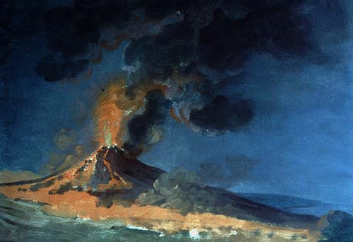
Is this the most famous volcano in the world? The shape is instantly recognisable: the twin peaks give the appearance of an unintended gap where something has been removed. Naples of course has the reputation that anything that is not securely fixed down can quickly and involuntarily change owner, so perhaps a missing bit of mountain is not such a strange idea. And whole towns have gone missing here. Pompeii and Herculaneum had been completely destroyed, and although the stories of the fatal eruption were immortal, in the writings of Pliny the Younger, the towns themselves had been forgotten. Pompeii was rediscovered in the 1500’s during the building of a canal. The find was documented but not pursued. Herculaneum was re-discovered in 1709. In December 1738, an inscription was found which labeled the excavated ruin as Theatrum Herculanensi. Only now was it realized that this was ancient, lost Herculaneum. The excavation of Pompeii began in 1748, at first rather destructively but later better organised and with great effort. Still, the site is enormous and much remains hidden under the layers of ash. The excavated part is very impressive. The numerous public buildings and original graffiti provide a less-than-flattering view of the morals of Roman life (‘bawdy’ would be a generous way to describe the culture) but bear witness to a practical attitude to town design. The access roads were especially well designed. The ancient bakeries along them provided drive-through food for the people on the carriages. Naples is the original home of the pizza (it is hard to find anything else to eat in its restaurants), and looking at Pompeii it is easy to see how this would have fitted in with the people on the carriages grabbing food from the passing displays using the pizza base as their plate.
In between the mountain and the sea, and amidst very fertile ground, this was a good place to live. Of course now we know better. The mountain is now recognised for the volcano it is, and the area to the west is known to be an active caldera. We wouldn’t build a town there. Except of course, this is where Naples did grow up, the only European city with an historical eruption within the city limits. Everything you see is volcanic, every single hill or depression a memory to some ancient eruption.

One of dozens of skeletons found in the boathouses of Herculaneum, of people killed but the eruption while waiting for rescue.
The local people are now well aware of their environment. The Vesuvius Observatory is the oldest volcanology observatory in the world, founded in 1841. At the moment the main area of concern is at the opposite side of Naples, at Campi Flegrei, where increased ground heat is present with some inflation. But Vesuvius is not forgotten. At the moment it is completely quiet, its fires spend in the 1944 eruption. This interlude will not last. One day the mountain will rumble into life again. The lava will flow, and it will not find a free channel to the sea. Anywhere it could go, suburbs have sprung up.
To see what the future holds, look at the past. Those who forget their past are condemned to repeat it. Our view of the past Vesuvius is shaped by this single destructive eruption of AD 79. What is a normal eruption like? How long is typical between eruption? History should tell.
Origin
Vesuvius began to grow around 17,000 years ago. There is evidence for 8 large eruptions, similar to the one in 79 AD or even larger. The main product from Vesuvius is andesite, known for causing explosive eruptions. Lava flows tend to be comparatively small in volume. The main impact comes from large explosive eruptions and associated pyroclastic flows. The cause of the volcanic is -obviously- underground, a combination of the subducting African plate situated to the east, underneath the Adriatic Sea (it is a pretty mixed-up region, with bits of Africa found in various places around Southern Europe), and extension.
Vesuvius is a grand cone, appropriately called Gran Cono, 1280 meters high. At the top is a round, deep crater where a few weak fumaroles can be seen but otherwise there is little evidence of activity. To the north and east, there is an arc-like rim surrounding Gran Cono, lower than the peak. It is called Somma, and is 1130 metes high. In the valley between the rim and the central cone are some old-looking lava flows. The rim is the remnant of an earlier phase of the mountain, 17,000 years ago when when a larger caldera formed. Not much of that remains. The combination of the rim and cone is called Somma-Vesuvius.
Since Roman times, there were significant plinian eruptions in 472 and 1631, although smaller than the 79 AD event, as well as an unknown number of smaller eruptions. The 1631 eruption signalled a change: after this, Vesuvius had frequent small eruptions, until 1944. Than it changed again, to its current silence. But how well do we know the history before 1631?

Lava flow, from a map made in 1833 by John Richardson (source: https://www.rc.umd.edu/gallery/map-vesuvius)
History
By 79 AD, Vesuvius was not considered an active volcano. It had been silent for long enough that it was seen as extinct, insofar that concept existed. There had been earthquakes in the decades before the eruption, and interestingly, the Pompei aquaduct has ceased to work. This may have been caused by local uplift around Vesuvius, causing the water supply to try to run uphill.

A list of historically documented events for the period 79-1631. Source: Claudia Principe and collaborators, Chronology of Vesuvius activity from A.D. 79 to 1631 based on archeomagnetism of lavas and historical sources, Bull Volcanol (2004) 66:703–724 . Click on image for full resolution.
After 79, people (at least the survivors) knew better. There were further eruptions, but quite irregular. The records of these older eruptions are fragmentary. Magnus Aurelius Cassiodorus and Procopius the Cæsarean allude to eruptions in 472 and around 512. The first one was major, with ash falls as far as Tripoli and perhaps Constantinople. The 512 eruption (the date is in question: 532 has also been suggested) was mildly explosive, for which a DRE of the fallout has been estimated at 0.025 km3. Procopius mentions lava flows which occurred during both eruptions, albeit his report is from hearsay as Vesuvius did not erupt during his own four-month visit to the area.
Paulus Diaconus (720-c. 787) mentions Vesuvian eruptions in two documents, and is also the first to suggest that the original Somma crater was related to the 79 AD eruption. He mentions the ash eruption of 685. After this, there is a period of 300 years where we have very few written records. There is a mention of events around 968 and 999. In January, 1037, lava flows reached the sea.
A large eruption in 1139 is stated in one account to have lasted eight, in another, forty days, but little is known about it. It has been argued that many of the lava flows on the side of the mountain, coming from parasitic vents, date from around this time. After this, there is little written evidence until the next big eruption of 1631. It is assumed that the mountain was mostly dormant over that 500 year period.
The 1631 eruption was a significant, plinian affair which caused many casualties. It came as a surprise: the mountain had been dormant since living memory. But living memory is not that long. A description from 1570 mentions highly active fumaroles in the crater with glowing rocks and occasional explosions, something that seems to have been forgotten about 60 years later.
After 1631, a very active period followed, with always something going on. Around 1770, Sir William Hamilton wrote that the mountain had for many years ‘never been free from smoke, nor ever many months without throwing up red-hot scoriae usually followed by a current of liquid lava’. Jospeh Wright made some 30 paintings of the mountain, invariably shown in eruption, even though there were no documented eruptions during his visits, around 1774. Eruptions were long lasting: the 1944 eruption was the culmination of an episode that began in 1913, with a peak in activity in 1929.
The 472 and 1631 eruption are classified as VEI4. The 79 AD eruption was VEI 5. The Avellino eruption, 4000 years ago, was significantly larger than the 79 eruption, and was a VEI 6.
472
This was during the collapse of the Roman empire. The area had seen widespread destruction caused by the invading tribes, and population was already in sharp decline. Into this stressed life, a major eruption happened. The prevailing westerly winds send the fall-out to the east, away from the sea, the opposite to what happened in 79 AD. The regions affected by the pyroclastics and ash falls remained de-populated for centuries. The coastal areas escaped the impacts, and stayed inhabited. From the locations of the deposits, the eruption column is estimated at 20 km height. It was big, but was not on the scale of 79.
1631
The 1631 eruption is famous. It began in the early morning of 16th December, with incessant earthquakes and ash fall. Mid-morning on the next day, a large eruption column formed. As the ejecta came down, the mountain seemed to disintegrate and material flowed down like water. It reached the coast and caused a tsunami several meters high. Before the eruption, the mountain had been densely vegetated, perhaps even inside of the crater. The mountain remained active for several years, although without the intensity of the first few days. After it, the mountain was desolate and some 3000 people had been killed. There were four more eruptions that century, a much higher level of activity than before.
The 1631 eruption changed our language. The word lava is Neapolitan by origin. It came from the Latin labe (to flow), and was used for volcanoes rather than rivers for the first time in 1633. How much lava was actually involved in the eruption is disputed. The written records mention seven ‘rivers of fire’ of which most were rivers of hot ash. Dating of some lava flows show that three flows on the southwestern slopes date from the 1631 eruption.
The eruption was probably similar in size to the one from 472. The eruption column was 15 km or higher.

The build-up to the 1631 eruption, from Emanuela Guidoboni, Vesuvius: A historical approach to the 1631 eruption “cold data” from the analysis of three contemporary treatises. Journal of Volcanology and Geothermal Research 178 (2008) 347–358. Click on table for full resolution
1944
The phase of frequent effusive and strombolian eruptions lasted for 314 years, with a slowly decreasing peak energy of the eruptions. It appears that over time, the magma slowly cooled and a plug build up making eruptions more difficult. The last one of the series was in 1944 and is well documented. It took place in the midst of the battles of the second world war and it caused significant damage to the allied bombers. The earthquakes started in early March. The diary of Leander Powers states:
Saturday, March 17, 1944. While we were just finishing supper, someone called to say there were huge red streams of lava flowing down the sides of Mount Vesuvius. It was a sight to behold. Never had we seen such at night, usually a faint red glow at the most. As we watched the streams, like giant fingers flowing down the sides, we could see a glow in the sky. All during the night and Sunday there were quakes of the earth with tremendous roars -similar to thunder- from Vesuvius. The windows rattled, and the entire building vibrated. (http://www.warwingsart.com/12thAirForce/Vesuvius.html)
It is interesting that it mentions the red glows seen before the eruption, showing lava was already present. The diary goes on to describe the lava flows entering Naples and the cinder cones and lava rocks. Finally:
Friday, March 30, 1944. The eruption seems to have abated very slowly during the past few days. Cinders and ashes have been raining down over all the villages in this section, but seem to be slowing up. The smoke from the crater is apparently changing from the intense black to white again. Yesterday, I looked at the Autostrade through my glasses, and it is apparently covered with cinders as is the entire mountainside. Only two weeks ago, I rode up the Autostrade and then walked several hundred yards up toward the crater. Yesterday afternoon, we rode in the ambulance, and, on the way back, we took a shortcut via Pompeii. Bulldozers were plowing the cinders to the side of the road in huge banks. Practically all the gardens and vineyards are covered to a tremendous depth in the area all the way from Vesuvius to Salerno. Many people are homeless and without food, but they seem to take it in stride, just as the Northerners take the snow in winter. After this eruption it’s easy to visualize the destruction of Pompeii – a most amazing and uncanny phenomenon. From my quarters I can still see what appears to be small areas with smoking lava, but the smoke from the crater has abated. Today, the wind is blowing inland, and it appears that cone is much lower than before. Vesuvius is definitely not dead after all these years of inactivity.
This is the only description I have found mentioning physical changes in the appearance of the volcano! The effusive event started on March 18. Lava fountaining happened on 21 March. Explosive activity happened on 22 March with ash falls at 500 km from Vesuvius. After April 7, there was no further activity. The cooling magma plug has now blocked the conduit. Nothing more has happened up to the present day.
Twin peaks
The most notable feature of Vesuvius is its twin peaks. Because the second peak is actually a partial ring, it is seen on different sides of the main cone depending where you are looking from, although it always looks double. But this aspect is not mentioned in the oldest descriptions.

Vesuvius about the Year 1500. From the earliest known engraving of the mountain and surroundings, printed 1514. Labels: 19, Palma; 23, Sarnus fl.; 24, Pompeii; 29, Turre Nunciatae; 31, Herculaneum; 32, Marilianum’; 33, Pomilianum; 35, Palæpolis; 38, Sebethus fl.; 39, Neapolis. Source: https://en.wikisource.org/wiki/Popular_Science_Monthly/Volume_69/December_1906/Vesuvius_During_the_Early_Middle_Ages

(Antonio Navarro, 2004 http://www.earth-prints.org/bitstream/2122/1468/1/04%20nazzaro.pdf)

The modern view
There is a written description from Strabo, less than a century before the 79 AD eruption. It states: “Above this locality Mount Vesuvius stretches. It is entirely occupied by beautiful fields, except for the top. The top itself is almost entirely flat but is quite barren, the land having a cinerous appearance; there are cracked cavities, opening on rocks sooty as if consumed by fire. We could suppose that this field previously burnt, and later its fire craters died out as the material burnt completely.”
This does not sound much like the current mountain: where is the mountain and where is the deep crater? It has been taken as evidence that instead of two peaks, there was only one mountain. It makes sense that the 79 AD explosion must have removed a fair amount of mountain, and therefore the appearance may have been quite different. But exactly what it looked like, and how tall it was, remains unknown. The description may indicate that the younger cone wasn’t there, but was a plateau at the level what is now the saddle between the twin peaks. Or the description may relate only to the central cone, and indicate it was taller than Somma and had no central crater.

The view during the Roman period, from a fresco. But is this all of Vesuvius?
There is one Pompeii fresco which shows only a single mountain, before the 79 AD eruption. This together with the absence of any mention of a second peak during this time, may suggest the younger peak did not exist. But the case is not clear, as the fresco does not show the full mountain. The drawing from 1500 looks very much like the current view. By 1631, the current mountain view was largely there, including the central crater which deepened by 450 meter during the eruption. However, the pictures show the old rim (Somma) to be considerably higher than the central cone, while nowadays the cone is higher. Could the younger cone have begun to grow during the early middle ages? It is not impossible – volcanic cones can grow surprisingly quick.
The next eruption
After eruptions in 1906, 1929, and 1944, Vesuvius has gone eerily quiet. The size of the eruptions had slowly been diminishing since 1631. The likely interpretation is that in 1631, an open conduit was created which since has slowly been blocking up as the magma cooled. Since 1944, it has remained blocked. What does this imply for the future?
Vesuvius seems a fairly unpredictable volcano. It has gone through phases of frequent lava flows, and times of infrequent explosions. We may now be at one of those times where it changes from one to the other. The effusive eruptions may not have completely ended: there is still a chance of another 1944-like eruption, with lava flows endangering the upper suburbs of Naples. But if the conduit is really blocked, the next eruption will be explosive. It will come from the summit: historically, this is where explosions happen. There will be warnings, with earthquakes, lively fumaroles and probably inflation within the crater and perhaps without, lasting for months. A large tectonic earthquake could increase the chance of an eruption a few years later, judging from the 79 AD event. Perhaps this can weaken the blocking plug, and create new channels for magma to rise, albeit at a leisurely rate.
To see how a new eruption might announce itself, the events of 1631 provide a clue. 60 years earlier, highly active fumaroles and glowing rocks were seen, indicating that a failed eruption took place. A few years later these signs had disappeared again. Explosions and landslides in the crater started several months before the eruption. Loud underground explosions were heard two months before, and at this time wild animals disappeared from the summit area. A few weeks before the eruption the vegetation was drying out, indicating degassing. Two weeks before the eruption seismic activity became strong enough to be felt by residents. Finally, the bottom of the crater began to uplift and a few days before the eruption, it had reached the rim. If this happens, it is time to swing the emergency plans into action.
How long would we need to wait for such an eruption? Based on its history, it could be a long time. The time of eruptions every 20 years is over. The dormancy before 79 AD may have been centuries. Before 1631, it was as long as 500 years, although there may have been smaller eruptions in the intervening period. We don’t have a long enough sequence to look for repeating patterns, and we don’t know what is normal and what isn’t. The current length of silence is not unusual, and could easily last for a century or (much) more.
The crater of Vesuvius is deadly quiet, apart from the buzz of the tourists walking around the rim. The fumaroles are hardly visible and nothing seems to threaten an eruption. This tourist heaven could last a long time, or Vesuvius could suddenly decide to rumble back into life. The only thing that can be predicted is its unpredictability. Vedi Napoli e poi muori! What a place to build a city.
Albert


Hiked Vesuvius last June 2022, Santorini’s Nea Kameni and Etna’s Crateri Silvestri followed, checking off another 3 items on the bucket list.
Don’t forget Ngorongoro. The mother of all craters. Hiking ill advised as meat eaters and other hostile forces roam free.
Duly noted!
The hilltop town of Civita di Bagnoregio in Italy might have been mentioned in a previous article about volcanoes in central Italy. It is slowly being washed away by the rain eroding the volcanic soil in the area. The town is now down to 10 people.
Vesuvious is quite alkaline in chemistry
Its produces Tephrites, Phonolites, Basanites depending on residence time in the crust. .. so its sillica undersaturated and No normal andesite by any means .. Vesuvious is famous for its Lecucite Crystals as well that can be found in its lava
An excellent article on our ‘friendly’ dormant Vesuvius. Thank you!
Askja, in Iceland, is doing some interesting ‘stuff’ today…
Just seen the seismic swarm that has started around herdubried….
Could be interesting…
Taal Volcano remains in Alert Level 1 despite of…
PhreatoMagmatic Events (PM) /SO2 tons per day (TPD)
10/21 – 29 PMEs/6702 TPD (Oct 20) — 16312 SO2(Mounts)
10/22 – 2 PMEs/6702 TPD (Oct 20) — 18589 SO2(Mounts)
I have wondered about the alerts for Taal, Volcano Island is on a permanent level 4 to stop people living on it, maybe increasing the alert for the whole volcano/lake is only if an eruption of large scale is expected. The eruptions now are small and dont leave the crater, so are not really dangerous.
This isnt to say there is no risk, but most eruptive episodes at Taal the opening is the most explosive, later eruptions are more magmatic and effusive. 1749-1756 episode was different but then it does stand alone, and the eruption in 2020 was not so big as 1749 nor was the probable intrusion, so a similar repeat probably wont be as big all thing considered. The erupted 2020 lava was also more andesite so presumably magma left from the eruptions in the 60s and 70s, not fresh new basalt which is what seems to be behind the known plinian eruptions from Taal.
Meanwhile in Iceland a new swarm started at 11pm, ~30km NNE of Askja
Herdubreid saw various swarms already in the past few years, every time it gets my hopes up haha Guess it is reacting to my comment the other day. An eruption there could look spectacular, depending on where it surfaces.
Over 500 earthquakes so far by the looks of it incuding a M4.0.
One of the Iceland volcano facebook groups had a post on these quakes, saying they are being watched but currently not believed to be volcanic, as in not a dike. But then the area is a rift, so this could evolve into something.
I do wonder if this is the same rift as Holuhraun. The dike from Bardarbunga erupted in a low elevation, but the rift could have kept going north past Askja.
The Herdubreid area is interestingly in the “elbow” between ERZ and NRZ with some faults connecting them.
From: Rift-Parallel Strike-Slip Faulting Near the Iceland Plate Boundary Zone: Implications for Propagating Rifts.
A good sundays afternoon read.
https://agupubs.onlinelibrary.wiley.com/doi/full/10.1029/2018TC005206
There are some ssw nne faults in the area where typically tectonic quakes around 5 – 10 km depth occur.
Andrej Fliss did nice observations on it. Nothing new these days I guess.
https://youtu.be/gvOSH70iCIY
The quakes in this swarm are actually not under Herdubreid, they are just east of a mountain that is possibly anothewr central volcano on the Askja swarm, at least there is a vent that erupted some andesite there and some old rhyolite. There have been a lot of eruptions in the same area, most recently are some fissures including the above andesite vent, but there are also a lot of shields. Flatadyngja shield just a bit south might be early historical in age although unobserved.
So actually, this might become something pretty interesting, it could be a slow eruption in the making that is to become a shield. It is way more inaccessible than Reykjanes but I think also more likely to actually have the magma available to produce a shield of large scale, lasting years, an icy successor to Pu’u O’o. If it does then that would also sort of prove that the shields are not really flank vents of Askja like the fissures are but their own sort of thing, monogenetic volcanoes.
It also might just erupt for a day and stop too, I wouldnt be surprised if there are a lot of historical but unobserved small eruptions in the north Vatnajokull area, at least on the sides of Askja itself there are.
Herdubreld also had a large swarm in the months preceding Bardarbunga / Holuhraun. Just a thought.
It was three months before Holuhraun in 2014. Things might be hotting up faster now (or they might not 🙂 )
That is why I proposed that maybe the rifting that lead to Holuhraun went further north than the eruption. The dike wasnt going to go further, Askja was there as a pressurized and high elevation, but tectonics are larger scale. If you go direct from there then the quakes now do line up roughly, like a second intrusion using the same rift. Rifts to the southwest involve both Torfajokull and Bardarbunga, and one of the Vatnajokull volcanoes did send a dike into the rift of Eldgja from the opposite end, this isnt a crazy idea.
During the propagation of the Holuhraun dike, quakes extended past the dike towards Askja and Herdubreid. One of the quakes at Askja reached M4.5 and the alert level for Askja was raised to yellow.
Rifting has recently (geologically speaking) happened to the north (Krafla) and to the south (Holuhraun), so this area is well worth to keep an eye on.
August 2014

September 2014

February 2015

Possible extension of the rift in light grey. Blue is the dike, the light blue arwa is what I imagine the connection to Bardarbunga was, not a dike but a sill given it intruded away from Bardarbunga at a strong angle to the rift, which I dont think a dike would do but a sill could with no issues. A conduit, perhaps like that which is found at Kilauea connecting its caldera with the ERZ, is another possibility.
Maybe calling this a true connected rift is a bit of a stretch but it is pretty clear that this general area of the crust experienced extension at the same time. This resulted in a large rift in the southern section – Holuhraun – which seems to have continued up to mid-late 2015. The section that is further north though didnt rift, and could be about to play catch up. The fact Askja is experiencing inflation now too after many decades of sleeping probably means there is magma on the way.
No sill. It would be silly (I couldn’t find a worse pun, sorry). The route of the dike can be well modelled from the local topology, including the sharp turn at the saddle. The dike could not go further as it ran into Askja. The current swarm is not related to this but may be due to extension along the main rift axis. The rift has a small turn north of Askja, and this can create a lower stress on the outer bend. Perhaps this is a small fault caused by this. A guess.
Near central volcanoes there are often dikes in directions that don’t necessarily conform to the general direction of the regional dikes. This is because the central volcano itself induces a strong local stress field which dominates over the regional stress. If you study dikes in eroded volcanic systems around Iceland you will find that close to the central volcano there are radial dikes and cone sheets, while dikes out in the fissure swarms follow the regional stress. I believe there’s a strong consensus that the Holuhraun dike started as a radial dike which then turned and continued as a regional dike before erupting.
The magma flow within the rift is a dike, but I dont know if it is properly known what the part actually connecting to Bardarbunga is. It could be a radial dike but such a big caldera as Bardarbunga would be pretty old and probably has many cone sheets and sills, personally I think the simple piston model is exactly that, too simple. Kilauea collapsed in the same way but to erupt in Leilani Estates the magma had to flow through at least one magma chamber, then a conduit, then between 2 and 5 satellite volcanoes, and it was only after this point about 15 km east of Pu’u O’o that a new dike was the mode of transport. And despite having all these apparent obstacles the eruption rate of Ahu’aila’au peaked at over twice the maximum eruption rate of Holuhraun.
I also recall there being activity at the connector for Holuhraun a lot longer than in the rift, which seems to have stopped before the end of 2015. Dikes can close up without pressure, but conduits or sills dont. The fact the Holuhraun rift has erupted at least 3 times in the past few centuries would argue to me that there is a more permanent and complicated connection to Batdarbunga than a radial dike.
I should say I dont refute that radial dikes exist at central volcanoes in ruft zones, just that I dont think that is what Houhraun was. Smaller eruptions yes, but big eruptions would need big and unobstructed plumbing.
A conduit is by its very nature an obstruction.
an open conduit isnt, especially not a wide one. And basalt magma at high temperature is extremely fluid, much less than most lava that is erupted is observed to be, it contains a lot of volatile elements that turn to gas at the surface but are contained in the liquid deeper down. Plume volcanoes like Hawaii and Bardarbunga are also the hottest of all volcanoes, potentially hundreds of degrees hotter than the liquidus temperature of basalt at depth and at least it is known for Kilauea that its magma system is in excess of 1200 C, possibly as high as 1350 C based on 2018 data (the ERZ magma storage is not this hot), I imagine Bardarbunga is of a similar temperature. The magma should be almost like water under those conditions, it would not be hard for it to flow through even small spaces, let alone large open conduits like probably exist at depth below where dikes form.
I am not sure what you mean. The Holuhraun lava came from the Bardarbunga magma chamber. The one-to-one correspondence between the eruption and the caldera collapse shows this, had the earthquake sequence left any doubt. The earthquakes trace a line from Bardarbunga, not a horizontal sill, so the only options are a pipe (‘conduit’) or a dike. At that depth it would automatically split the rock into a dike system. And of course, with perhaps 1km3 of magma left in the dike or pipe, a pipe would have to have a diameter of 200 meters to accommodate that much magma. How would you make that?
I think you missed something, the conduit is the part that is radial from the caldera, where it turns north is where I think it became a dike. Maps of the whole earthquake swarm that I have found have a gap between the dense seismic areas of the rift and the caldera fault.
https://encrypted-tbn0.gstatic.com/images?q=tbn:ANd9GcTe1jQwFkZ1r_QgYmaAIpdA2c9KTYGbLoru1Q&usqp=CAU
In case it is unclear I think the gap is a conduit or some other more permanent structure, that a dike then grew north from. If I could make a 3d model I would. Its never really sat with me the simple models of Icelandic volcanoes, not after seeing how the magma systems in Hawaii look.
A ~4,000-year old version of Pompeii found near Naples, buried during the Avellino eruption: https://arkeonews.net/the-bronze-age-village-afragola-buried-by-the-plinian-eruption-of-mount-vesuvius-4000-years-ago/
Whoever chose that photo for ‘arkeonews’ published it reversed. The hiking path is the clue.
Mauna Loa would have had a star at its summit had it been in Iceland. M3 under the summit
(Of course Iceland would not look the same with Hekla replaced by Mauna Loa!)
If Hekla was replaced with Mauna Loa and Kilauea then probably all of the South Iceland volcano group would be buried 🙂
Mauna Loa is going to erupt in the next couple of years, HVO did a presentation on it recently and the earthquake patterns are reminiscent of the leadup to the last two eruptions, albeit still not immediately leading up. The recent quakes at Hilea are a telltale sign, not the initiation quake, but they show weakness. I would bet the next quake is there and before years end. And if Mauna Loa isnt ready to push that way yet then it may not matter, Kilauea is beginning to intrude its SWRZ and may well induce the Hilea area to slip by itself, Kilauea is probably affecting Mauna Loa a lot more equally than is usually assumed, it isnt simply sitting on the side.
Mauna Loa is fun for me but I wants it bigger ..
So I plops down Ra – Patera on Iceland ( everybody dies ) 😜
And in Northen Iceland I place
Loki Patera
Bwhahhaha! Hähähäh hugh kwefff!! cough!
Alberts response: ”quite typical of him …”
Jesper ought to sit down and write the screenplay for his favorite volcano arc’s most definitive disaster motion picture. I trust the choice might be difficult.
IO is my kind of place…. the most powerful and most active hot sillicate volcanoes in this solar system
Addicted to Jupiters Moon IO
Now there’s an imaginative location for a screenplay!!
I mean, to be fair I think Hawaii is probably a lot bigger volume in total than a lot of the Ionian volcanoes, they dont really have much topographical prominence, and most dont really seem to overflow, so dont build big structures. Loki might have effective output of near 0 m3/s, it is like at Kilauea, where a massive lake is present and fed at high rate but it is nearly completely countered by drainback so the net input is low, hence its quiet overturning cycles and enormous thermal output. Pele is the same but with much higher flow rate, like a continuous curtain of fire really given the scale of fountaining (low gravity helps).
The volcanoes that do overflow or actually erupt though those are beyond anything we can observe on Earth today, probably examples of LIP scale volcanism. I guess if volcanoes on Io did form taller structures then there would also be true flood basalts, the 1997 eruption at Pillan Patera was the closest with confirmation but it looks like a much bigger eruption happened there in 2015. I guess we will see when the new flybys happen 🙂
Ionian volcanoes still dwarf anything on Earth today 🙂
My favorite Moon
Yes Big Island complex have more mass.. Althrough Ionian magma capacity dwarf anything on Earth today
Loki, Pele .. Ra, Twasthar, infact all black spots on IO are sites of Mega basalt volcanism
Alot of IO s surface Is covered by older snowed over basalt lava flows .. that are probaly related to overflows of these Patera lava lakes .. and thats stuff of Insane scale, Ra Patera seems to be a shield volcano, Ionian lavas are very fluid so it forms basalt flood plains. Maasaw Patera is another
Surt 2001 was an insane eruption as well in thermal energy, Pillan erupted many times after 1997 and that arera looks probaly unregonicable today. The 70 km wide Pillan Pateras floor was filled by lava flows in 1997 .. cascading over the 2 km high patera walls, in the biggest lava falls in the solar system, today it Maybe filled competely.
Im very very excited for Junos Visit in 2024 .. But we seriously needs IO Volcano Observer .. titanium and water Ice are good radiation blockers .. so needs more probes to photograph IO
Loki Patera is insane stuff really .. Hopes Juno takes closeup photos of that one
A small swarm at the end of Reykjanes, just off the end. Been many such swarms, there will probably be an eruption here some point and the area did erupt in the early 1200s. But the area also flares up shortly before other intrusions have happened, including before the two eruptions. So good to keep watch on the area again 🙂
Hekla in person is amazing. Almost a little frightening.
https://i.imgur.com/HrnwRSL.jpeg
https://i.imgur.com/TNihVLB.jpeg
https://i.imgur.com/KYpVlmd.jpeg
Even though we’re mostly doing the north coast this trip my wife had to forgive me for devoting an entire day to one of the meanest volcanoes on earth.
Wow. Yes, that is an impressive view
PERSONALLY…. I wouldn’t be hanging out near the summit of Hekla.
Last it went funky, the associated quakes could not be felt by a human until about 15 minutes until it went boom.
… but, that is just my opinion.
Yes, it is a scary volcano. On the other hand, the 15 minute warning was at a time when eruptions were more frequent. After long quiescence, it seems there is more precursor activity: an eruption in the 19th century had a full day of warning. It has now been 20 years of sleep, and the awakening may not be quite as fast as 15 minutes. I wouldn’t count on it though
Well, that 15 minutes is based on what is human perceptible WITHOUT any instruments.
I think IMO saw it starting on their seismos about an hour and 11 minutes before boom-boom.
If it is based on human perception, that actually makes it worse, i remember when Kilauea began in 2020 that people up at the summit didnt feel anything and watched as a massive glow and steam plume presented itself. Same thinh happened September 2021, felt tremor within an hour then eruption.
I think this says more of the ability of us to recognise the warning than there being particular lack of it.
All I am trying to get at with this is that the many people who climb Hekla are not uniquely applying for a Darwin Award, I am sure the mountain would be more restricted if the risk was really that extreme. The bigger danger is always the weather, climbing an Arctic mountain with a high elevation.
Quite a number of eruptions have also not involved the rifting of the whole mountain, even some pretty big ones, I have been mapping the vents recently and at least on preliminary observation the eruptions only generally trend on the same line, its more like a small rift zone than an actual polygenetic fissure. It is definitely still very sketchy but someone caught at the summit when an eruption begins is not facing death with absolute certainty. 1970 eruption someone at the summit would be mostly fine, and the 1991 eruption only affected the southern half of the volcano the north was not touched.
I feel like Hekla gets a particular sort of notoriety for this that is a bit undeserved. The danger is real but sudden eruptions like this are far from unique worldwide, a lot of stratovolcanoes are like this and I think everyone forgot how Kilauea managed to take HVO by surprise in 2020, erupting from green alert in an hour…
Also Hekla doesnt just ‘go off’ it has to recharge like all volcanoes, its supply is robust at about 0.1 km3 a decade (about the same as Etna or Piton de la Fournaise) but with that number it isnt going to just somehow do a Holuhraun sized eruption now and has the possibility of doing that at any given moment, its a powerful volcano for sure but lets be realistic… The thing that GVP doesnt distinguish is all of the basaltic flank eruptions from those on Hekla itself (let alone Vatnafjoll which is in the same fissure swarm but has magma from further southwest). All the big historical eruptions at Hekla over 1 km3, in 1104, 1300, 1510, 1766 and 1947 all took place after at least a century of sleep at the central volcano. An eruption in the next decade will be bigger than the last 4 but not close to 1947 or 1766. I think a basaltic eruption in the immediate area is more likely before the central volcano erupts again. That will be a rifting event, it could be a powerful eruption, and potentially a large volume, but we will definitely see it in advance… 🙂
It’s not the amount of erupted material that’s scary about Hekla. It’s the violent opening phase. Even a small eruption measured in dense rock equivalent output has an opening phase in the don’t be there category. But I agree with Albert. It’s likely to give a bit more warning next time around.
Yes the opening minutes of 1947 was INSANE and also concentrated to shorter fissures than Hawaii and Galapagos … potentialy leading to higher fountains
Althrough Kilaueas big mafic plinian eruptions are insane stuff too
I mean, I think being at the epicenter of any volcano that is somewhat active is a bad idea. I havent been able to find good evidence Hekla is actually particularly violent for a VEI 4-5, although it is violent for being an Icelandic volcano.
I wonder if some of this is from the historical reputation. Hekla was the go-to volcano to blame for anything in Medieval Europe, and those without knowledge of Icelandic as a language would probably assume its name as being sinister, I used to think it was the Icelandic word for hell.
It’s the history and “aura” for me. It just felt otherworldly being only a few kilometers from a mountain with so much historical significance for Iceland, and so much reputation.
Not sure I’d feel that quite the same way if we instead went to Indonesia and saw Krakatau in person.
Site of one of the most violent eruptions in recent history? Absolutely. Would it be cool for lots of reasons? Absolutely.
But Hekla just has this aura about it IMO that is a proper mix of scientific, superstitious, and sociological.
And, it helps that it’s just a very, very cool looking mountain sort of all by itself in a beautiful landscape. I joked to my wife it has a tendency to unzip straight across its width.
I haven’t been close to many other volcanoes, but I can say that standing in a field 20km from Hekla looking at all the lava bombs scattered in the landscape is a quite humbling experience.
Thanks Ryan for the pics! If you’re going to the north I can recommend a visit to Mývatn. The geothermal bath is really nice and there are lots of accessible volcanic features, including Hverir with steaming fumaroles and boiling mudpots just next to the road.
You’re probably already aware of it, but keep an eye on the weather forecast and plan your trip back to Reykjavik carefully. Roads are often closed during bad weather and can make it impossible to get back from the northern parts.
Thank you Tomas! We’re in Akureyri right now and it has to be the most beautiful location I’ve seen in my life. Just unbelievable unending vistas in every direction. We’ve been incredibly fortunate with the weather, as it’s been crisp and cold but absolutely clear and beautiful. Very tuned into the weather and are ready to adjust accordingly.
We were in the Siglufjörður and Dalvík area today, and it was just perfection.
Heading to the Mývatn area tomorrow.
https://imgur.com/a/ewWKAV9
Found this just now, a well rendered map of the bedrock under Vatnajokull. This is basically what the place will look like in about 150-200 years. It is pretty likely at this rate of decline even by 2100 this view will be mostly true too… 🙁
It is pretty clear that Bardarbunga is the big player here really, very clearly defined caldera that has collapsed many times, probably every time a big rift has happened, just as we saw in 2014. Likely means there was a collapse in the 1860s with the Trollahraun and Holuhraun II eruptions, in 1797 with Holuhraun I, 1477 Veidivotn, 1250 Frambruni, and 871 Vatnaoldur. The caldera as we see it now might have formed from Thjorsahraun, but there are some massive Holocene lava flows that are older than that so the caldera could well be pretty fundamental. All of the others have a bit more of a soft edge, including Grimsvotn, so these calderas might be a little bit more monogenetic. Bardarbunga seems to have a Galapagos type caldera that is a fundamental part of the volcano, it probably formed as a shield (maybe in the last interglacial?) but then formed the caldera and it has been there ever since. The others seem to be more Hawaiian type calderas that form in big eruptions and dont necessarily reactivate on the same faults in the next one, so they form nestled and overlapping calderas. Also shows in the eruptions, Bardarbunga erupts relatively rarely and often on big scale, Grimsvotn erupts much more often and also usually from the same place, and generally on a small scale. It also looks like Kverkfjoll might be a lot more of a serious volcano than it has shown to be in recent times. maybe it erupts rarely, but its two calderas are almost as big as those from Bardarbunga, each, and are bigger than Grimsvotn.
Also, it was a topic of discussion on Esjufjoll a while back, it looks like it doesnt have a caldera at all from this view nor any real evidence of being active recently, it is probably not dead and could have erupted in 1927 but definitely a sleepy volcano.
Þórðarhyrna dosen’t seem to have a caldera either, hard to even tell where it is on the map.
Think Oraefajokull and Esjufjoll will be quite dangerous once the ice cap pressure has receded.
They’ve had time to evolve a bit and are away from the main hotspot source.
Could be some Aleutian-style eruptions.
Also the gap between – does this trace the old MAR before it did a switcheroo rift jump?
Oraefajokull yes, Esjufjoll though honestly doesnt look like it is even really a volcano at all rather than just an erosion feature.. very much in need of a proper study to try and access the risk there.
There is apparently a large caldera there, Snaehetta, but this is quite unclear (and not really locatable on the map above). A poorly studied volcano, which is rare for iceland. I suspect nothing has erupted there in a long while. There does appear to be some sort of edifice near Reynivellir looking at that map – north east of Oraefajokull past the inlet.
The quake swarm near Herdubreid is slowly moving towards Askja. It also shows no signs of slowing down. https://twitter.com/FragenuberF/status/1585244388514738176
Yeah it seemed to be slowly declining other the past few days but seems to have picked up again since moving to the new location on the west side.
Interesting to look back at these with reference to the current activity:
https://volcanocafe.wordpress.com/2012/05/15/herdubreid-renewed-activity-at-askja/comment-page-1/
https://www.volcanocafe.org/seismic-unrest-and-the-future-of-volcanism-at-herdubreid/
Is it reactivation of the old system? Or will it ultimately end up connecting up with Askja?
Given the state of Herdubreid it is likely plugged up and solidified.
Albert’s comment that Herdubreid acts as an obstruction in the area is interesting. It may prevent rifting northwards, and thus an eruption would likely occur south-east of Askja.
Albert’s comment that Herdubreid acts as an obstruction in the area is interesting. It may prevent rifting northwards, and thus an eruption would likely occur south-east of Askja.
Working on my next VC article will be about one of the most insane eruptions ever seen in the Galapagos Island chain .. from a historical persons old shiplogs ..
Found some insane stuff really : O
Will be fun .. and probaly will be posted in Christmas
That will be fun!
Yes looks like a real night – mare eruption
They where a kilometer from the ocean entry yet .. the sea got almost to boiling point and 50 C air temperatures.. and some crew members died of heat stroke and suffocated from the water vapour
The whole skies was lit up and 3000 feet tall fountains ”all along the crater” was seen .. and the whole cone flooded by lava … the eruption keeps going at slower rates for 8 months .. so I think we are talking about over 1 km3
But They where there at the opening night When all hell broke loose
Martian seismology revealed a newly formed meteorite impact crater on Mars:
The InSight Lander gave scientists a Christmas surprise in 2021, but it took a while to figure out. Read the whole story here:
https://www.nasa.gov/feature/jpl/nasa-s-insight-lander-detects-stunning-meteoroid-impact-on-mars
Impressive. Thanks for this!
I don’t understand the second photo in the linked story. According to that photo (with the dimension), the dark shadow in the crater is on its left side, while all of the small craters visible in the photo have shadows on the right side, implying that the sun is shining from the right. It doesn’t make sense, especially since the short video clip shows the shadowed side of the crater on the correct side of the crater. Did they show the crater boundary in the wrong location?
The ‘small craters’ you mention are actually small rocks. The sun is very low on the left. You can see that the shadows of the rocks are elongated. Craters wouldn’t do that.There is one small crater on the top left in the first image, and it has the shadow the same way as the impact.
Thanks Albert. What made me think that they are craters is the semicircular outline of most of the shadows. They must be fairly round “rocks”. Now that I think of it, they might actually be made of ice, because the sunlit side is very white, unlike most of the material in the photo, and were probably ejected from the crater.
I wonder if the white material is ice, or some kind of salt precipitate of some chemical composition ? or co2 ?
The NASA article identifies it as water ice: “New craters also expose materials below the surface. In this case, large chunks of ice scattered by the impact were viewed by MRO’s High-Resolution Imaging Science Experiment (HiRISE) color camera.”
I don’t know if they also have spectroscopic data proving that it’s water ice. Collecting multiple pictures over time will help to figure it out as water ice will sublimate, i.e. the white boulders should shrink and then just disappear. Salt would just get covered up in dust.
Magnitude 3 earthquake 20 km under Kilauea, right under its summit.
Things could get interesting if this is related to magma movement. The quake itself is not a volcanic tremor but in this location it is hard to imagine being unrelated to the volcano.
Radegast Patera IO
Looks like this is an image of an acual molten lava lake on IO! .. its so very smooth and dark and smooth around the edges, it haves to be a liquid surface with a thin skinn. There is an even darker spot that Maybe a fresh resurfacing crust where older crust sinks back into the molten basalt lava. Albert whats your opinion on this as well ?
http://www.gishbartimes.org/2009/02/common-features-among-ios-mountains.html?m=1
Lowest photo and enlarge it
Photo NR 4
https://www.youtube.com/watch?v=HH28u1QnOIE
Mauna Loa status report in Pahala yesterday.
Summary, seismicity now is comparable to before the last two eruptions, inflation is not as fast but has gone up more in total since 1984 than it did between 1984 and 1975, or before 1975. So basically there is not an imminent eruption now and things are not exactly certain, but it wouldnt take much to erupt now.
Meanwhile the GPS at Kilauea caldera has slowed, the caldera is not extending much now. Most of the GPS stations are also showing downward trends, as well as accelerated south motion. The south flank at Hilina pali might be slipping, a slow slip event as they call it. So Kilauea might be temporarily robbed of magma at Halemaumau as the pressure is lowered, it might even stop erupting. These slow slip events happen every couple years, the last was supposed to be in 2018 but we all know what happened then 🙂 so this is probably the first since then.
The south flank of Kilauea probably needs to move the allow Mauna Loa to spread, the 1983 quake happened not long after major rifting associated with Pu’u O’o, so this could well end up being a big trigger.
Forgot to say there was also some information on the deep quakes under Pahala, aswell as some pictures showing their enormous increase in recent years. Even in 2018 when they became well known the swarm was small in area, now they cover over 100 km2 and have greatly expanded in area in just the last 2 years since Kilauea began erupting again.
Maybe most importantly to understanding, all of the biggest quakes happened right at the margin of the swarm pointing direct at Kilauea. So the idea they are connected there seems to have more merit.
Reminds me a lot of Ol Doinyo Lengai. The top of the volcano was flat, as can be seen in the Angelina Jolie movie Lara Croft Cradle of Life. That was in 2003. Four years later there was a ginormous crater after the volcano erupted in a VEI 3.
There’re several fine videos of the sodium carbonate lavas from that volcano prior to the 2007 eruption, like this one. Quite amazing. It’ll take a while for the ” rel=”nofollow ugc”>crater to refill up to the top again.
Oops, sorry the second link inserted itself. Ah well. That’s a big hole to fill back up!
Regarding the fresco in San Gennaro extra Moenia (thanks for the post), I found this:
https://en.wikipedia.org/wiki/San_Gennaro_extra_Moenia
Seems that the fresco is well. Might have been restored lately?
Has there been any actual investigation into what is causing the earthquakes at Herdubreid? I have seen some plausible ideas that they represent tectonic stress quakes from the inflation at Askja and are not themselves magmatic, a bit like the quakes at Krysuvik and Grindavik when the dikes at Fagradalsfjall formed, or the Kaoiki earthquakes when Kilauea or Mauna Loa move relative to each other. But then, the quakes at Grindavik also have been associated with intrusions too, and now that is also said to be the same at Krysuvik… It is honestly confusing at this point…
I think if Askja was inflating enough to induce this sort of stress around it too, that there would be more coming out about the danger. I saw on a video that Askja has been said to have enough magma now available to do a ‘very large eruption’, though no numbers were given. Based on nearly all of its Holocene eruptions the next eruption will probably be effusive, and likely a circumcaldera fissure eruption of which there have been many unobserved since settlement before and up to 1875. Askja in terms of structure seems to be the same as a Galapagos caldera, a magma chamber that is a thick sill or maybe several sills, with eruptions along the rim of the caldera. Eruptions from these types of calderas can be extremely intense compared to normal Hawaiian eruptions, something as big as Holuhraun erupted in only a week is possible, they are structural analogues of LIPs. ‘Very large eruption’ could imply something even bigger is expected. I dont thibk there is any rhyolite left but if a couple km3 of basalt erupts into Oskjuvatn I dont think that really matters…
“Has there been any actual investigation into what is causing the earthquakes at Herdubreid?”
That’s exactly what I’ve been wondering (and what has brought me out of a period of hibernation from VC). It looks to me like the eqs have been getting shallower since the swarm began – though that may be an illusion owing to the fact that much more data is being processed manually and so we are getting (more) accurate readings. There seem to be a high proportion of eqs < 3 km, which may imply non-tectonic causes, mayn't it?
Ryan posted some pics of Hekla a few days ago and there was a discussion about Hekla's explosiveness. I visit the Fjallabak area quite a bit but I find it hard to get out of my mind that Hekla throws substantial rocks 30-40kms, which would make more than a few ripples on the hot pool at Laugar… Sobering.
I noticed the possible shallowing too, although because nothing was said and I still dont really know how to read earthquakes properly I assumed it was nothing serious. But they are still going now I think there is something to it.
With all seriousness, there are a lot of videos of Hekla eruptions where people are rather unbothered by being near the eruption. Even flying within a few km of the volcano during the intense opening stage in both 1946 and 1970, and climbing the mountain while it is erupting. Nothing I have been able to read anywhere except through second hand reports (mostly recirculated on here…) has said Hekla is any more explosive than any other VEI 4 or 5 volcano, it sort of has a bit if a legend around it (which probably goes back many centuries), but maybe that is clouding an objective judgement. Same thing is what lead the world to call Kilauea harmless for a century, until it was investigated seriously and now is the USGS volcano with the highest risk rating… Maybe being on top of Hekla when it erupts is Carls irrational fear, but only he can answer that I guess.
So to anyone around Hekla, if there is any level of alert, maybe dont climb it, but you can watch it erupt safely from the road. It would look spectacular at night. The way things are going though the mountain is probably going to sleep for a while, next eruption is probably going to be a basaltic vent.
Hekla earthquakes. The rate is increasing.
Carl’s descriptions of his fear of Hekla have certainly influenced my attitude to it, but then I wouldn’t want to be near enough to be injured to any potentially explosive volcano that had given only (?) 35 minutes warning – and that to an experienced seismologist.
I was reporting from my recollection of an Icelandic source I read that gave fairly precise figures for mass and range of rocks exploded from Icelandic volcanoes. Don’t know how that relates to VEI. Perhaps it’s my imagination (and the changes as one gets into the Highlands) but whenever I drive past Hekla, I am struck by how far the farm buildings keep from it.
In the olden days it was much more forested. The farmers got rid of this. I think the land is now pretty poor, and perhaps the fluorine is not helpful either. But over the centuries, one farm after another met Hekla’s destruction. And do be aware, 6% of all on-land lava in the world comes from Hekla.
Yes, over-grazing, etc – true. But W and SW of Hekla the land is good for farming – lush and green, and evidently farmed – but there are very few buildings once one gets to say (I could check, but haven’t time) 20ks of that upturned boat that likes to suprrise us.
Curious. The only historical eruption with ash blown mainly south was the one in 1947.
Why do you live in despair over your broken down volcano?
Time to learn why it is misbehaving!
https://www.volcanocafe.org/why-is-my-favourite-volcano-broken/