1 million people visit Vesuvius each year. It is a big number which involves a lot of people struggling up the steep and dusty path to the rim. Rather more people visit the more accessible archaeological monument to Vesuvius that is Pompeii: counting those as well brings the total to 2.5 million. It makes it (reportedly) the most visited volcano in the world.
But that reported ‘fact’ isn’t true. Even including Pompei, Vesuvius appears to be only number 3. It falls well behind Yellowstone (4 million) and Mount Teide (3.5 million). Elsewhere in the world, Mount Fuji attracts 2.3 million, Mount Hood 2 million (albeit to the forest rather than the mountain), Auckland collects 1.7 million (many of whom may not realize what they are visiting), Etna sees 1.5 million, and Kilauea gets a measly 1.3 million. Who’d have guessed? Further down the list of volcanic glory, Taupo has close to a million visitors each year, Mount Halla (remember that one?) 900,000, and Mount Bromo 800,000.
It does depend on what counts as ‘the volcano’. Jeju Island, home to Mount Halla and entirely created by this single volcano, attracts a staggering 13 million visitors per year. And likewise, if Mount Teide may be substituted by Tenerife, its numbers increase to 6 million. These are a long way ahead of Vesuvius – and don’t you feel sorry for poor Kilauea? Of course, the large majority come for normal tourism and not for the volcano, so perhaps this is unfair competition.
Visitors to Tenerife are 8 times more likely to go up Teide, than tourists at Jeju Island are to go to Halla! The reason is obvious: there is not much else to do in the bleak (personal opinion) tourist resorts in the south of Tenerife – names of resorts such as ‘Oasis del Sur’ promise rather more than they deliver. I can recommend Puerto de la Cruz as much nicer, but it has less sun (a plus, in my opinion) and no beach (which is another plus).
At the other end of the ‘true volcano’ scale, Mount Erebus gets some 50,000 visitor each year, which is still rather more than I would have expected. Visits to Barren Island (the sole Indian active volcano) are very few (and uncounted) for reasons to do not only with the name but also with the fact that it takes a full day to travel there and back from the nearest habitation, and overnight stays are not allowed.
But there is one volcano missing in this list of volcanic popularity. Santorini, never listed, is visited by 2 million people per year. Many of the visitors may not realize that they just landed on a volcano, and would be worried to discover its devastating history – and its potentially equally destructive future. A bit of advice may be welcome: avoid travel insurance which excludes ‘acts of god’. Pele is hiding in many places, and she does not have a good reputation. As Belle says in Beauty and the Beast, there’s something in him that I simply didn’t see. (Admittedly she found the beauty in the beast, rather than the beast in the beauty.)
Santorini

‘Stunning’ is the appropriate word. The views of the white houses and blue domes below the blue sky, above the azure sea and the dark volcanic rim, attract tourists like moths to a flame. It is considered the most beautiful place in Greece. The most famous images are from the capital, Fira, but the whole island is exquisitely beautiful. Visit in summer and you may find the tourists shoulder to shoulder, crowding out the 16,000 inhabitants. Spring and autumn are better if you like some personal space. And if you don’t mind a bit of inclement weather, winter is the quietest time, albeit for a reason.
Santorini lies at the southern end of the Cyclades, a series of over 2000 islands which litter the Aegean Sea between the Greek main land, Crete and Turkey. Here, there is an island for everyone. Santorini, at the bottom of the Cyclades, is the crowning glory. But there is a something hidden in this castle. There is Beauty – and there is the Beast.

Source: Greekreporter.com
The geology here is equally fascinating. This is a complex region where several plates interact. We wrote a bit about it before. The Aegean Sea plate (a microplate) is being pushed southwards by the Anatolian plate (itself squeezed west by the Arabian plate). Southward, the African plate is kind-of subducting. Crete is the non-volcanic pushed-up part, while to the north of Creta a volcanic arc has developed. There are 12 documented volcanoes in this arc, stretching over 5 volcanic centres from Methana (near Athens) to Kos (near Turkey). Three of these volcanoes are submarine. Santorini is the best known and most active of those 12 volcanoes.

Source: Cantner et al. Blue triangles are submarine volcanoes, red subaerial ones.
It is a volcano with history. Santorini is the site of the oldest known (and successful) complete evacuation of a town because of an impending eruption. It is also the site of the oldest known fatalities from an eruptive sulphur poisoning. (This ‘fact’ has not been fact-checked though.) Those tourists should perhaps feel a little apprehensive about the lack of indicated escape routes.
Santorini has had many names. The current name dates only to the 13th century. Before that time it was known as Kallisti, and before that as Thera, a name that is still often used but actually refers to an ancient city on the island. The oldest recorded name is Strongyli. This plurality of names already shows its age. There were thriving communities here as early as 6000 years ago (although we do not know what name they gave to their home). Santorini is located close to the major centres of early western civilization. Life here could be good.
Volcano!
The island has a funny shape: it consists mainly of a fairly thin arc which partly surrounds a large bay, with a steep edge dropping into the bay. The arc has a large opening on the east side and a smaller one on the northwest, so that it is not a single island. The central bay has all the hallmarks of a flooded caldera, and that is indeed what it is. At the centre are two smaller islands, Palaea Kameni and Nea Kameni: both are volcanic and were formed through ashy eruptions. These two islands are still volcanically active, are largely uninhabited, and are much younger than the rest of Santorini.

There are other volcanoes in the region. Christiana Island lies 20 km SW and the Kolumbo submarine volcano is 7 km NW, where the latter has erupted in historical times. There are also some 20 submarine cones. But Santorini is the volcanic boss here. It is a repeat offender: at least 12 explosive, Plinian eruptions have been identified. These happened in the past 350,000 years ago. The volcano itself is twice as old but the older volcanism was less explosive.
Santorini made headlines around 1600 BC when it single-handedly removed a dominant civilization from the eastern Mediterranean. (This well-known ‘fact’ has not entirely survived a fact-check.) The main city of the time was Akrotiri, and the people living there were the Minoans.
Akrotiri was already an ancient town. Although only rediscovered in 1967, it started more than 4000 years BC as a small fishing village. From 2000 BC it developed into a trading centre, with evidence for both pottery and copper. The copper was traded between Cyprus and Minoan Crete, whilst the pottery came from all over the Mediterranean. Akrotiri was more than a merchant import-and-export business: the copper was also moulded here. The town became prosperous. The houses were full of frescoes, a good indication of wealth.
The eruption around 1600 BC is one of the defining moments of the history of the eastern Mediterranean. Before the eruption, the shape of Santorini was different. The current caldera wasn’t there: instead there was a smaller caldera, also flooded, in the north of the island. This hole had formed 20,000 years earlier in an older eruption. There was an island inside this caldera, an older version of Nea Kameni. If you wonder how we know this, one of the frescoes found in the remains of Akrotiri depicted the landscape, complete with a fleet leaving and arriving. We know that the caldera was flooded because the explosion debris contains remains of stromatolites. Santorini itself was a round island – in fact Herodotus calls it Strongyli, ‘the round one’. Soon it wouldn’t be.
The Beast
Akrotiri came to a sudden end when a major eruption buried the town under meters of ash. It is now much like Pompeii: a buried town that was lost in history. Excavations of the town have shown us a window on the past, including those frescoes. But unlike Pompeii, not a single human body was found entombed in the ash. People apparently were able to leave in time.
The excavations of Akrotiri have shown that the eruption did not come out of the blue. It appears that the first trouble came from a significant earthquake, perhaps as strong as M7, which destroyed the town. In itself this is perhaps not unusual: this is an earthquake zone. The destruction from this event is seen in other island across the southern Aegean Sea: this was a larger tectonic event, a disagreement between the various plates. But Akrotiri was rebuild, more luxurious than it had been.
Perhaps 50 years later there was again serious damage in Akrotiri from an earthquake. There is a layer of debris on the streets and squares containing meter-sized blocks from walls coming from this event. People put up temporary housing while clearing debris and starting repairs. But those repairs were never finished. Some weeks or months later, Akrotiri was suddenly abandoned. The reason is not clear, but volcanic or earthquake activity is a possibility. The abandonment was well organized. The people took valuables with them (almost nothing valuable has been found in the excavations) and put food into secure storage.
A phreatic eruption now deposited a thin ash layer over parts of the island. There followed a hiatus during which things calmed down again. This may have been weeks or months.
The main event began with a plinian subaerial (on-land) eruption, from a location between modern Nea Kameni and Fira (neither of which existed, of course). It deposited as much as 7 meters of pumice and ash near Fira – although much less further away. Akrotiri received around 1 meter. This was a major eruption: the eruption column may have been 30 to 40 km high. As many as three pyroclastic flows are included in the layer.
The character of the eruption now changed to phreatomagmatic, as the vent moved south and dropped below sea level. The new layers of surge deposits are up to 12 meters thick.
The next phase was the most voluminous. It came probably from the same vent as the previous phase. There were further pyroclastic flows, but also mud flows which may indicate caldera collapse. The deposits are up to 55 meters thick (!) although that is reached only in valleys. The flows were unable to get over the caldera walls. Blocks up to 2 meters in size are included.
The fourth phase brought the ignimbrite as the eruption column collapsed. While the previous layers were mainly closes to the vents, this layer covers the outer areas of Santorini. Near the caldera rim they are 1-2 meters thick, but on the coastal plain they reach 40 meters. Together, these four phases may have lasted up to 4 days.
The volume of the eruption was around 33 km3 DRE, which would make it a VEI 6.5. There are claims for volumes which are 2-3 times larger but these seem based mainly on the size of the caldera. The caldera was in part already present before the eruption, and therefore this overestimated the eruption. This ‘fact’ seems too optimistic! The eruption was larger than that of Krakatoa, but although it is often compared to Tambora, Santorini’s Minoan eruption was not quite that size.
The eruption completely destroyed Akrotiri and buried it under 6 meters of ash. The 35-km plume pushed the sulphate into the stratosphere. However, the eruption was relatively sulphur-poor, and so climate impacts may have been limited. No clear sulphur spike has been identified in the Greenland ice cores, although there are a few candidates.
The date of the eruption is surprisingly poorly known. Tree rings, carbon dating and archaeology indicate that it happened sometime between 1650 BC and 1550 BC. But the local olive trees do not form good tree rings, and this also happens to be a period where carbon dating has large uncertainties. Recent papers have argued for slightly earlier than 1600 BC or as late as 1540 BC, not in particularly good agreement. Currently, a date closer to 1600 BC seems most likely, but this is a fact that might change.
(How can you read this? There’s no pictures! – Beauty and the Beast)

A picture
Tsunami
The eruption spread pumice rafts around the Aegean Sea, identified for instance extensively in Crete. It also caused a tsunami, which is often mentioned as widespread and catastrophic. The thick deposits off the coast of Santorini (up to 80 meters thick) make a tsunami more than likely, with the caldera collapse adding to it. Old Krakatoa’s eruption caused several tsunami waves for different phases of its eruption, and this has led to the assumption of a major tsunami event coming from Santorini. On the east coast of Santorini there are indeed thick tsunami deposits, especially in between the main pyroclastic flows. Modeling suggests the wave here may have been 35 meters high.
But there is only limited evidence for this tsunami elsewhere across the Mediterranean. Old tsunamis are difficult to identify: storms, flash flooding and tsunamis all produce similar deposits. (A possible sign is marine molluscs far above the high water line.) It is a bit easier when there is evidence for destruction of buildings, but even there, there is often more than one possible cause – including earthquakes. They can also be difficult to date.
Tsunami deposits associated with Santorini have been identified mainly in northeast Crete and in southwest Turkey. Claims for their existence further afield are more dubious. Some old studies find evidence for flooding mixed with pumice, but pumice will have taken weeks to months to get that far while a tsunami has to come very much earlier. Currently, it seems that a significant tsunami did affect the Aegean Sea and a devastating one hit Santorini itself (where no one was left to notice), but there is no evidence for impacts elsewhere in the Mediterranean.
An example is the ancient coastal city of Palaikastro on Crete. It was among the largest cities of Minoan Crete, and is a strong case for a Santorini-derived tsunamic destruction. There is volcanic ash from Santorini, plus a turbulent layer with marine shells which is carbon-dated to the era of Santorini. Further in-land, the ash-layer from Santorini is on average 5cm, in places up to 12 cm thick. The tsunami seems to have arrived shortly after significant airborne ash was deposited. Based on comparison with the 1956 tsunami, a 35-meter high tsunami at Santorini may have cause a 7-meter one at Palaikastro. The observed damage would in fact have required a 9-meter high wave, so this seems consistent. It was sufficient to inundate the town entirely.

Source: Vasıf Şahoğlu et al. 2021
Çeşme-Bağlararası, on a bay on the Turkey’s west coast, has been argued to have been hit by multiple tsunamis over a period of days. It shows layers of ash deposits and sand amongst collapsed buildings. These have been interpreted as caused by a series of three tsunami waves, perhaps hours apart, with ashfall in between. Afterwards, there was a quiet period during which people briefly attempted repairs, but a fourth wave destroyed these efforts. A skeleton which was found in the debris may be the only known victim of Santorini’s Minoan eruption! But it is not yet confirmed that this was indeed a tsunami. Elsewhere on Turkey’s southwest coast, the ash lies on top of the tsunami deposits, indicating the water wave arrive first (as would be expected given the travel speed), but this is not the case at Çeşme-Bağlararası. The evidence from there is not as secure as that of Palaikastro. Overall, the facts of the tsunami story of Santorini are somewhat less than fully established.
Minexit
The eruption certainly ended the Minoan occupancy of Santorini. Whether it also ended the Minoan civilization itself is often stated as a fact, but is unproven.
The main base of the Minoan civilization was Crete, an island that was affected by the ensuing tsunami. Their main towns were along the coast and may have been badly damaged. These towns were devastated by the eruption – but not destroyed. There was a lot of rebuilding afterwards with fine masonry, showing that the people and their skills pulled through.
Many ships (and their sailors) will have been lost, and the military supremacy over nearby Greece may have been severely weakened. Some decades to a century later, the Minoan civilization collapsed, and their writing adapted to the Greek language: they had been taken over by Mycenaean invaders from southern Greece. But was that a direct consequence of the tsunami? Or a drawn-out process with many causes? The Minoans were the traders of their days, and the loss of ships may have been a big problem. It has been suggested that a lot of their trade came via Akrotiri and that they lost an important trade route. But there were no palaces on Akrotiri, suggesting it was never as important as that to the Minoans.
Maybe it was just that they were unable to recover the dominant trading position after an absence of some years, and that the decline was direct consequence of less wealth. The terminal blow came from the Mycenaean invaders, but that came after a long decline. It may have started with the Santorini eruption, but that sounds a bit like blaming the political chaos in the US on the St Helens eruption.
Bittersweet and strange, finding you can change. Learning you were wrong. – Beauty and the Beast
The bigger beast
The Minoan Santorini eruption was not a unique event. Santorini’s explosive history goes back 350 thousand years. Over that time there have five eruptions large enough to form a caldera, of which the historical event was the most recent. (We’ll have six or seven! – Beauty and the Beast.)
As in many similar volcanoes, such eruptions are cyclic. After a caldera collapsed destroys the lid on the magma chamber, eruptions become frequent, smaller and less explosive. Later the eruptions the magma becomes more evolved and eruptions less frequent but larger. The cycle ends with a climactic eruption which leads to a new caldera collapse. In the case of Santorini, this cycle can take 50,000 years or more.
Before Santorini there was ancestral Santorini. This volcano existed from 650,000 to 350,000 years ago, when the eruptions were mainly effusive. The transformation from ancestral to modern Santorini happened when the eruptions became explosive. Before that time, this was a likeable neighbour volcano, a bit like the friendly fire eruptions of Iceland. Or so people thought.
Santorini sits at the edge of the Agean platform, the shallow area where all the islands are located. The platform contains some deeper basins. One of these is located west of Santorini, the Christiana basin (home of the separate volcano island of that name) and to the northeast is the Anafi basin; they are around 400 meters deep. The explosive eruptions of Santorini have left their tephra in those basins.
Recent drilling in these and other nearby basins uncovered a thick bed of pumice, tuff and ash, underneath around 50 meters of more recent deposits. The deposits are up to 150 meters thick. Further from Santorini the bed consists mainly of ash. The predominance of pumice suggests that the eruption that caused it was mainly – but not exclusively – shallow submarine. The distribution especially of the larger fragments indicate that they came from an eruption near Santorini itself. The composition of the tuff (ratio of various elements) is similar to that of Akrotiri deposits dated to ancestral Santorini, and quite different from what was erupted by Santorini or other nearby volcanos (Christiana, Kolumbo) during the time of modern Santorini. That is consistent with the age of around 510,000 years, during ancestral Santorini. The tephra has also been found on the islands but the layers there are much thinner. That suggests that the eruption was mostly (but not entirely) submarine. The eruption was rhyolitic, at a time ancestral Santorini was mainly erupting basalt.

The deposits are interpreted as turbidity currents generated by submarine pyroclastics. The volume of these deposits are estimated at around 90km3. This is a lower limit for the eruption, as it only counts what is detected, and does not count what was deposited elsewhere, such as pumice rafts. Correcting for the measured density of the layers gives a DRE volume of 30 km3, again a minimum value.
Thus, this eruption was at least as large as the Minoan larger, and probably was larger as the volume is based only on the submarine pyroclastics. There are similarities to Hunga Tonga, but the eruption may have been a bit deeper and it was considerably, perhaps ten times, larger.
The eruption must have left a caldera but this has not been found. It may have been located between Santorini and Christiana, in the region where the tephra is thickest: a distant vent of ancestral Santorini has been suggested. This was during an interstadial, when the climate was warm and sea levels high. The vent was submerged under shallow water.
The eruption was around the time that ancestral Santorini changed and became ‘younger Santorini’ with different magma. Did the explosion perhaps trigger this change?
In any case, Santorini is no Prince Charming!
The mini-beast
In the summer of that same year of the eighth “Indiction’, steam as from a fiery furnace bubbled up from the depths of the sea between the islands of Thira and Thirassia for several days, and in a short while, after it had increased and hardened by the furious heat of the blazing fire, the smoke began itself to seem like fire, and on account of the thickness of this solid matter, large pumice stones were spewed out all over Asia Minor and Lesvos and Abydos and towards those parts of Macedonia which overlook the sea. (Theophanis the Chronicler, chronicling the Nea Kameni eruption of 726. Source: https://www.santorini.com/santorinivolcano/kameni-islands.htm)
Currently, Santorini mainly erupts at Nea Kameni. These are effusive eruptions which have build up the island over the past 2000 years or so. The eruptions come from a short fissure at the centre of the caldera which runs through both the younger Nea Kameni and older Palaea Kameni islands. There have been nine documented eruptions at Nea Kameni, in 197 BC, 46 AD, 726, 1570, 1707, 1866, 1925 and 1950. The two Kameni islands together have a volume of 4 km3, likely coming from these and other undocumented eruptions.

Time line for the growth of Nea Kameni. Blue: offshore; green: onshore. Source: Nea Kameni Geological Park, https://santorinivolcano.gr
Recently, drilling was done on the seabed within the caldera to investigate the eruption history of the Kameni islands. A high resolution seismic profile was also obtained of the caldera. This profile is shown below. It is taken along a rather complicated path which runs through both gaps in the caldera rim and around the Kameni islands. On the plot, the top is at sea level – everything that is shown is submerged.

Seismic profile of the submerged caldera of Santorini. Source: Preine et al 2024.
The profiles and drilling cores showed five main layers, lying on top of the ‘acoustic basement’ which is expected to come from the caldera eruption of 1600 BC. They are called, somewhat factually, L1 to L5 where ‘L’ stands for ‘layer’. Layer ‘L5’, at the bottom of the pile, seems to come from the oldest lava flows of Kameni, which may have happened before the first reported eruption in 197 BC. Layer L4 seems to be non-volcanic, and consists of landslides or stream beds. L3 is again a layer of volcanic ash, deriving from several eruptions as it is itself layered.
Layer L1 is small, at 0.3 km3, and may come from the eruptions between 1570 and 1950 which build up most of Nea Kameni.
Layer L2 is the notable exception. It is a rather thick layer of pumice and ash, with a large bulk volume of 2 km3. The only historical event that fits this deposit is that of 726 AD. It was reported at the time that ‘the sea produced ‘steam as from a fiery furnace’ and that pumice covered the sea and reached Turkey. The pumice in L2 suggests this was indeed that eruption. There was not much tephra known from this eruption, so was mostly submarine and it was not thought to have been large. But the new data makes it a much more significant eruption. The event was probably centred between the two Kameni islands. An ash layer found in the sea over some 10 km distance can now also be identified with this eruption, adding another 0.4 km3 to the volume. That number does not yet include the pumice that escaped the caldera.
The surprise is how large this small eruption of 726 truly was. Here the ‘fact’ erred on being too cautious. There is an expectation is that eruptions early in the cycleare small, and in fact all other known eruptions at Santorini have been no more than VEI3 or 4. But the 726 eruption was a VEI 5. To put this in context, the volume was twice as large as that of St Helens in 1980. It appears that even in its current state, Santorini can do far more significant eruptions than we have seen and expected. The 726 eruption was not strongly explosive – it was no Hunga Tonga. But it could still be problematic, and the pumice could badly affect shipping in the region.
The sudden collapse of Anak Krakatau in 2018 showed us that rebuilding a volcano after a major demolition is far from safe. Anak Krakatau was sitting on a sloping basement, and the cone eventually slid down this basement. It may be a worry that Nea Kameni is also sitting on a slope, with the northern basin being much deeper than the southern one.
As an aside, in the year 727, the Byzantine emperor Leo, under pressure from the advancing muslim armies, tried to take control of the church and tried to put the pope under his authority. This attempt would eventually lead to the separation of east and west in Europe. The Eastern Roman Empire and the Franks under Charles Martel would now fight the invading armies separately, and the church began the process which would later lead to a break-up between the eastern and western church. It has been suggested that Leo had been frightened into action by the eruption and damage to sea travel done by the pumice. But there is no written document that makes any connection, and we can attribute this to coincidence. Sometimes there are no facts, just speculation.
I can feel it. We’re getting close – Beauty and the Beast
The other beast
7 km northeast of Santorini lies Kolumbo, a submarine volcano. Never noticed before, it sprang into action in 1650, when an eruption breached sea level. Before this, the existence of this volcano had not been known. The sediment near Kolumbo shows no evidence of any other eruptions after the Minoan event, only this one. 1650 was indeed an awakening after a long post-Minoan sleep. Kolumbo rudely intruded on the age of baroque. (If it’s not Baroque, don’t fix it. – Beauty and the Beast)
Kolumbo is the largest of a series of some 20 submarine volcanic cones which stretches out in this direction, called (rather blandly) the Kameni-Kolumbo line. (I guess ‘KK clan’ would have been a factual but not acceptable name.) These cones formed on a 40 km strike-slip fault, which apparently acted as a weaknes allowing some magma to pass through.
The activity had started in the previous year. Strong earthquakes were felt in 1649 and continued into the spring 1650. After a calmer period, the earthquakes returned on 14 September, now accompanied on Santorini by roaring sounds. The shaking continued for two weeks, strong enough to cause rockfalls on Santorini.
The eruption was first noted on 27 September, when clouds of dense smoke and flames were seen rising from the sea. Sulphur clouds reached Santorini and pumice was covering the sea. The series of eruption plumes continued during the 28th. On the 29th, the eruption became much stronger. The eruption column was now said to blot out the entire sky, and incandescent ejecta and lightning was seen. Large rocks were thrown out as far as 8 km. Ash fell in Turkey. (Earthquakes were also reported from Crete but this may not have been related.) One explosion was heard 400 km away.
On this day, the sulphur cloud over the northeast coast of Santorini became so dense that people suffered intoxication, with blindness, confusion and in some cases unconsciousness. Some 60 people died from this. The activity ceased late on the 29th of September, but only for it to resume strongly the next day. A few days later, on 2 Oct, the crew of a ship was found dead at sea, with burn wounds: they died from a pyroclastic cloud. This took fatalities to 70. After that the eruption became much less. There was again a stronger explosion in November, before it finally petered out in early December and Kolumbo went back to rest.
The deadly eruption formed a crater 2.5 km across and 500 meters deep. The total eruption volume was around 10 km3, half tephra and half pumice. It was a VEI 6, although not all of this volume was explosive. It was comparable to Hunga Tonga, with the explosive component amounting to perhaps half a HT.
Tsunami
But there was more, as Beauty and the Beast says, Something that wasn’t there before. A major tsunami hit the region in the evening of 29 September. The tsunami destroyed two towns on Santorini, and swept away churches, boats and trees. The water first retreated before reaching 14 meters above sea level. (Local reports that the flood reached 2 km in-land cannot be correct. No tsunami deposits have been found there and it would have required a far higher wave.) On nearby islands, it reached run-up heights of 20 meters, possibly 30 meters on Patmos.
Originally the tsunami was attributed to collapse of the central crater in the climactic eruption. But this was questioned: models could not represent the pattern of run-up heights on the various islands in the region well, and eruptions tend to cease completely after the collapse but in the case of Kolumbo continued for two more months, including some large explosions in November. The tsunami is now considered to have been cause by a flank landslide.
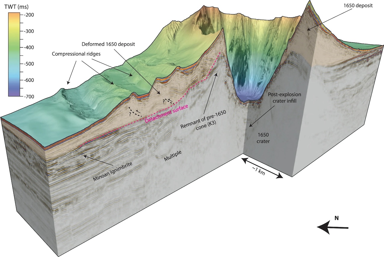
Source Karstens et al. 2023
Seismic mapping has shown the presence of ridges on the northwest slope of Kolumbo. These indicate a landslide, and this is a potential cause of the tsunami. Models show that such a 1km3 slide, followed by an explosion 4 minutes later, can fit the tsunami pattern and heights. The explosion is suggested to be caused by depressurisation of the flank following the slide.
Activation
The big question is what caused Kolumbo to suddenly become active in 1649, after thousands of years. Why out of the blue (sea) this sudden major eruption? Why did this Beast, who concealed himself inside his castle (Beauty and the Beast), reveal himself? There are four other known layers of volcanic debris underneath the 1650 layer, showing the presence of five large eruptions. The dates are not clear, but it covers at least 70,000 years (and possibly much longer). This is not a frequent eruptor! It likes its sleep.
Kolumbo has its own magma chamber, about 4 km deep. The magma is silicic but there is also a small component of mafic magma which comes in at a very slow rate. It is probably this hotter magma which destabilized the existing magma. Models indicate an average inflow rate of around 6 kg/sec. (That is less than 0.01 km3/century.) The inflow rate is such that mafic magma adds about 10% to the chamber over 10,000 years. Five eruptions over a period of 70,000 years suggests that a level of 10% to 15% mafic magma may cause the silicic magma to become unstable. The critical level was reached in the 17the century, magma began to break out and events followed.
It will take a long time for that level to be reached again. The risk of another eruption at Kolumbo in the foreseeable future seems not high. But volcanoes are not always predictable.
The future beast
You have no reason to trust me, and an excellent reason not too – Beauty and the Beast
Tourists on Santorini all head for the caldera rim for the views of the sunset. It is a good place to reflect on the past. Santorini’s beauty has grown from devastation: it is beauty from the beast. And while admiring this window on the past, perhaps there should be a little trepidation about the future as well. The beast may be asleep, it has not gone. The most likely location for a new eruption would be at the Kameni islands, at the centre of the touristic views. What a sight it would be. But perhaps too close for comfort.
Albert, September 2024

(An AI generated future – sorry, could not wait for reality to catch up)
References
Dávid Karátson, et al., Constraining the landscape of Late Bronze Age Santorini prior to the Minoan eruption: Insights from volcanological, geomorphological and archaeological findings. Journal of Volcanology and Geothermal Research, Volume 401, 2020, 106911. https://www.sciencedirect.com/science/article/pii/S0377027319306316
Sturt Manning, Second Intermediate Period date for the Thera (Santorini) eruption and historical implications. 2022, https://doi.org/10.1371/journal.pone.0274835
Vasıf Şahoğlu et al., Volcanic ash, victims, and tsunami debris from the Late Bronze Age Thera eruption discovered at Çeşme-Bağlararası (Turkey). 2021, PNAS, 119, e2114213118. https://doi.org/10.1073/pnas.2114213118
Hendrik Bruins et al., Geoarchaeological tsunami deposits at Palaikastro (Crete) and the Late Minoan IA eruption of Santorini. 2008, Journal of Archaeological Science, Volume 35, pages 191-212
Jonas Preine, et al., Hazardous explosive eruptions of a recharging multi-cyclic island arc caldera. Nat. Geosci. 17, 323–331 (2024). https://doi.org/10.1038/s41561-024-01392-7
Druitt, T., Kutterolf, S., Ronge, T.A. et al. Giant offshore pumice deposit records a shallow submarine explosive eruption of ancestral Santorini. Commun Earth Environ 5, 24 (2024). https://doi.org/10.1038/s43247-023-01171-z
Karstens, J., Crutchley, G.J., Hansteen, T.H. et al. Cascading events during the 1650 tsunamigenic eruption of Kolumbo volcano. Nat Commun 14, 6606 (2023). https://doi.org/10.1038/s41467-023-42261-y
K. Cantner et al., Integrated volcanologic and petrologic analysis of the 1650AD eruption of Kolumbo submarine volcano, Greece . Journal of Volcanology and Geothermal Research 269 (2014) 28–43
Konstantinou, K.I. Magma chamber evolution during the 1650 AD Kolumbo eruption provides clues about past and future volcanic activity. Sci Rep 10, 15423 (2020). https://doi.org/10.1038/s41598-020-71991-y


From last to first (post-wise).
Fascinating article, Albert. Once again the impact of vulcanism on humanity comes into full focus after understanding the fact and fiction of one of the most famous places on Earth.
Regarding the chain of submarine activity, are these volcanoes largely monogenetic or indicating prolonged periods of activity followed by dormancy and/or extinction? From the reading, it seems some have a long eruptive history, while others look like they only burped once (or maybe a couple of times) before going back into eternal quiescence.
You are welcome. This was quite a hard post to write. Too much fiction amidst the facts. This region seems to have prolonged activity for each volcano, albeit with long periods of dormancy. The many submarine cones of the KK clan might be monogentic – I think that isn’t well known. But by and large, these are long-lived volcanoes
KK clan really shouldnt catch on…
You and Jesper might like this film about a Yellow Anaconda in Iberá jound by me recently and appreciated:
Great piece. Considering that they had all left – no skeletons or skulls – and the newer dating it seems possible that Tell-al-Hammam was destroyed before, and that place was one of their main trading partners.
If we acknowledge that the Old Testament might contain a few grains of truth there might have even been the habit of pederasty in both societies, imported to Tell el-Hammam by the Minoans.
Whatever it was it might have scared the shit out of the Minoans. Or the climate changed to colder periods, and the olive trade collapsed.
https://www.nature.com/articles/s41598-021-97778-3?error=cookies_not_supported&code=09deb40c-bab8-4642-90f7-24bab7050dbe
Glad you liked it. I know the paper you refer to. It seemed very unlikely to me when it was published and I have not changed my opinion since. The Tell was damaged – but the evidence that a comet or asteroid was involved was not convincing to me.
Could be they were just wise enough to do an orderly evacuation when the earthquakes began. Also – thinking of HTHH – that there was a smaller volcanic eruption at the beginning.
The surroundings of Christiana southwest btw look like a mini version of Santorini just underwater on SAT images, Christiana standing for Kameni.
Btw you might like that film about that Yellow Anaconda as well and other readers too. For me it was important distracting me from a sometimes exaggerated fear and loathing of snakes.
Those two people in the film take the snake from Formosa in the NW of Argentina and set it into Iberá a little further SE, an area that has partly been modeled as a National Park with a rewildering project set in motion by Douglas and Kristin Tompkins. They chip the snake, give it a name and follow it through pairing and birth of offspring while also watching some Black Caimans. Then I found more about the Iberá project which I consider phantastic and important. There are more projects like this running all over the world, I saw one about Montana and one about Pumalin, Chile.
Iberá looks strikingly beautiful. Their biggest pride is the rewildering of the Giant Anteater, the Giant Otter, the Macaws that have to learn to fly again first and, above all, the Jaguar.
The imported Burmese Python in Florida is a totally different story. 90% of all native mammals have by now disappeared in the Everglades as the beast has not many natural animals, the alligator being too small. A big burden because of some stupid people in the Nineties who dumped their pets there.
On the 19th and 26th of June 2022 I checked off two items on my bucket list by hiking to Vesuvius’ summit and that of Nea Kameni in the Santorini caldera. These were my second visits to these sites, the first occupying other interests related to each of them. Having already digested Sigurdsson’s signed papers on Vesuvius, I took with me to Santorini Freidrich’s excellent ‘Fire in the Sea’, and the publication the link to which I’m providing below:
http://www.geomorph.org/wp-content/uploads/2020/03/Santorini-Field-Trip-September-2019_RCG.pdf
Thanks Albert for a fascinating voyage! So many fine titbits of vulcanology and history.
One thing about Santorini is perhaps the VEI6.5 could be upped to a full seven if underwater mass flows could be accounted for. That was an interesting finding about Hunga Tonga, that submarine pyroclastic flows or lahars (or whatever they were) went for a hundred kilometres – and took out seabed telecoms cables.
Another fascinating thing about Thera is the Sea Peoples, who may have been migrants from tsunami-affected Minoan Crete. They turned up on the shores of the Eastern Med out of nowhere. Then there’s the coincidence of the Phoenician seafaring city states in that same area not long after…who then became the Carthaginians, that gave rise to the Punic Wars and the whole Roman thing. So one single volcanic eruption may have affected European history for a thousand years!
Then too I like also your mention of Methana, which is another historically fascinating volcano, since it is just south of Athens. And probably made Athens. And Sparta, Corinth and Thebes for that matter. So many early city states are associated with volcanoes because of the fertilization effect of volcanic ash and the enhanced agriculture that the volcanic ash supported. Methana and her nearby sisters probably enabled the Mycenaean culture to be possible…who then colonized Santorini and Crete. So a couple of Aegean volcanoes could well have driven European history for four thousand years, up until today at least. 😀
I confess when I read the article title I instantly thought Stromboli not Santorini which sent me off searching my library. I am surprised Stromboli doesn’t figure in the popular tourist volcanoes you had at the start. She’s been erupting pretty much continually for over a century.
That’s why I went off to my library, since a fine historical account is Unbroken, by Alistair Mars. A story of a small British submarine in 1942. They sailed past the erupting Stromboli volcano on 8 August 1942 whilst being chased by a whole bunch of irate Italian navy ships (p 100). The story is a fine and rollicking tale, and adding in an erupting volcano is a cherry on top of it.
I could not find visitor numbers to Stromboli, so didn’t mention it for that reason. I figured it would have to be fewer than Etna or Vesuvius, being on a more remote island, but didn’t get further. Perhaps someone knows?
The Sea Peoples date from 400 years later, so are unlikely to be related to Santorini. Their origins are not well known but genetic evidence points at southern Europe. Assuming the the biblical ‘philistines’ are the same group, they may have come from Crete, based on one place name mentioned in the bible but this is far from clear. Anatolia has also been suggested. But in any case, this is long after the Minoan civilization disappeared.
Yes, except similar studies of Mycenaeans is they’re also from southern and eastern Europe. At least a large component are, since they had a lot of Anatolian heritage as well.
The conflict of dating is interesting, but often such gaps close as more data is collected. For example there was the Hyksos crisis in Egypt around the time of Santorini per the earlier dates. They were coastally based in the Nile Delta area.
Nisyros was perhaps my favourite volcano to visit. Teide had very sharp brown rubble everywhere, and a vast and desolate craters of the moon. Vesuvius was redder and smaller ejecta – slippery and loose, and so a very scary and massive edifice. Nisyros in contrast is white. The sides of the caldera are a dazzling white, and the floor is flat and dotted with smoking holes. The information provided at the site is very informative and the island seems to have day visitors rather than tourists to any great extent, and so most of the island is forested and the deep caldera is a great contrast to the surrounding hills and valleys.
You mention the Sea People and this event is the one that I believe brought an inland sea from North America into the Atlantic, off the coast of Nova Scotia, when the ice walls lifted at the end of the last ice age. Markings on the seabed support this hypothesis. All around the UK there are areas of drowned forests and local legends of the lost lands of Lyonnesse off Cornwall, of Cantref Gwaelod where Cardigan Bay is now sea, of Dogger Bank in the North Sea, of the Isle of Ys off Brittany, which was where the King of Brittany kept his gold, and the same around Scandinavia. People were on the move. I suspect that The Black Sea filled then, thank you Noah, and Ancient Greek cities disappeared around the Mediterranean. But this was 400 years later after Thera, you say?
I had also understood that the Santorini eruption of Thera lasted such a long time that crops failed in Egypt, for seven years, and Moses and his tribe were thrown out, to follow a pillar of light by night and a column of cloud by day, to cross a shallow sea during the moment when the massive eruption drew the water away, into a deep depression as the island blew sky high, before it then launched the tsunami which covered Crete. This climate catastrophe over many years would also have caused people to go in search of other lands from all around the Mediterranean, hence the problem with invasions.
Thank you for your knowledgeable dating of these events. Diodorus is a good source for the ancient history of Sicily as he was told in 300BC that half the island had been laid waste by an eruption of Etna more than a thousand years before.
Local memory and local stories preserve the histories from before writing and books
The Santorini event was perhaps a root for the Atlantis Myth of Platon. The white houses on the slopes of present Santorini look like a small resurrection of the old visionary ideal of a human society that the myth describes.
The Sea Peoples were maybe the first Mediterannean Empire from Carthago to Tyros. It was probably not a real empire, but some kind of a family of culturally related states. The Philistines who are famous actors in the bible, belonged to the Sea Peoples. They were very different to the Arab Palestinians. The historical conflict between Israel and Philistines was one between a semitic shepards state and a high developed culture which descended from Minoans.
I feel like its a pretty likely story that Atlantis was basically made up and inspired by Greek history and memory of the long line of successive civilisations to be spawned in the Mediterranean. Not specifically the Minoans, but going back through the whole Holocene, maybe even back to the culture of Anatolia that made Gobekli Tepe. Lots of ancient ruins and modern structures are circular, so that part might just be an easy fantasy.
To be honest I wouldnt be surprised if Pleistocene people were just as creative and inspired to do this stuff as in recent time, and if not in the glacial maxima maybe the prior interglacial. Its really not until the last few centuries we have made a mark on the planet big enough to endure in geological time. But nowdays trying to take that all seriously means you also believe in ancient aliens and the ‘master race’ so isnt taken seriously.
While I’m here RÚV has an article today:
Magma accumulation continues under Svartsengi (11 Oct)
I haven’t ever been able to find a live version of the inflation graph that IMO puts up from time to time, so I don’t know how this current increase is going. But from the tone of the article it looks like Reykjanes is still on track for yet another eruption in December or thereabouts.
More likely a malfunction related to the recent solar storm.
https://www.vedur.is/gogn/gps/reykjanes.html
Uplift graphs here.
https://www-vedur-is.translate.goog/um-vi/frettir/jardhraeringar-grindavik?_x_tr_sl=is&_x_tr_tl=en&_x_tr_hl=en&_x_tr_pto=wapp
Recent update from IMO here.
Ooh, pretty! That’s gone straight into my bookmarks. Thanks!
Bruce, please let me know if you can see this webpage? https://docs.google.com/spreadsheets/d/1lTsu9yk1_fOfy3EMcwXpGEVKi2yEImaEXsRLaubNFj8/edit?gid=228464627#gid=228464627 Bruce Garner sent this link to me. It appears that we have to wait until December, or even next year, before the next fissure eruption occurs. He has 3 other spreadsheet posts, based upon the GPS movements.
Yes it comes up for me! Nice! I’m chuffed as a few weeks ago on another thread I said the rate of inflation would suggest a Christmas present. Mr Garner’s projection hits the red line on 24/12/2024. 😀
I’d have to say the rate of inflation is a little faster though than his pink trendline, so maybe it will be earlier. Of course likewise it all depends on whether the magma can find a way to the surface, and where that is. My impression is the locus of the current intrusion is further north and east than the previous episodes. Which would suggest tougher rock to get through.
I predicted Christmas Eve a while back, then realised my calculations were wrong, but I decided to stick with it.
Inflation has currently a concave tendency (right-wing curve). Inflation is still positive, but is decreasing a bit. If this continuese, next eruption will probably be 2025. Maybe we get a pretty winter wonderland eruption. Not enough snow for a jökulhlaup, but hint of the “Fire and Ice events” that Iceland can do.
Santorini is one of the few active caldera systems that poses a significant risk for the surrounding population, I didn’t know it was such an effective erupter in the past 1000 years. Great article
Any of these realistic for ancestral Santorini?
https://flic.kr/s/aHBqjBMGBH
Nisyros-Kos-Gyali is postulated to have had it’s mega-eruption 600,000 years ago also
Great article, Albert. Thank you!
Thanks Albert. I visited Nea Kameni a number of years ago. The structure does seem quite transient, with lots of loose material.
On the subject of tsunamis, while evidence is lacking, I can’t imagine that they wouldn’t have travelled beyond Crete and the other neighbouring islands and coastlines.
Interesting point, but note how well the Aegean Sea is walled in by Greece, Crete, and the islands to the west: Karpathos and Rhodes. Waves that get through the gaps will act as if creating a new point source and spread out forward in all directions. This spreads out the energy. I estimate from the gap sizes and distances that when reaching the African coast, the wave will be down by a factor of 10.
Thanks for this fantastic virtual visit to Santorin, Albert!
Since the beginning of high human civilizations in the Mediterannean area and Middle East, this was probably the “boss” eruption. Maybe Vesuvius’ Avellino eruption 3,800 BC was close to the size of the 1600 BC Thera eruption, both VEI 6. Unlike Vesuvius Santorin does big tsunamis, these tsunamis are proabably the biggest to expect in the Mediterannean Sea.
I’d consider the Santorini volcano together with Krakatoa as one class of volcanoes. They do repeatedly over a long cycle Plinian caldera collapse eruptions.
Etna collapse may have caused a larger tsunami locally, and certainly a more widespread tsunami. Whether or not this coincided with eruption I don’t know.
Ive seen somewhere that the Avellino eruption was not particularly big, just the last notable eruption before 79 AD. It wasnt anywhere near comparable to Santorini in the Minoan eruption. It might have been bigger than 79 AD but wasnt a VEI 6. But im nit too familiar, I only know it as the example used as the worst case eruption threat to Naples, but pyroclastic flows are very variable in distance depending on lots of factors. Also, that Vesuvius probably even at its worst is probably still a better case than any eruption of Campi Flegri…
Both Santorini and Krakatoa are in a half oceanic and half continental position. That’s unlike Hunga Tonga and many (unkown) ocean arc calderas around the Pacific Ocean, where oceanic plates meet each other. It is also unlike purely onshore calderas like Tambora, Novarupta, Crater Lake, … that can’t do tsunamis during the caldera collapse.
Campi Flegrei Caldera is relatively close to this type, but it lacks the central island which is typical for Santorini (Nea Kameni) and Krakatoa (Anak).
I think central islands are just a symptom of whether a caldera is weaker in the center or the edge, and if that caldera is flooded. Vesuvius is a cone in the caldera of old Monte Somma, and all volcanoes like it (probably most big stratovolcanoes) are called somma volcanoes. The Kameni islands and Anak Krakatau are young somma volcanoes, still growing quickly in the latter. Volcano Island at Taal is also one, it is a lot bigger though, but so is Taal in general. I guess Halemaumau also is within Kilauea or at least maybe it could have been in 1924, perhaps not today.
Campi Flegri isnt like this, its vents are around the north edge of the caldera. Maybe some were islands uplifted but its hard to tell. Campi also is probably a lot closer to its next big event too, relatively speaking. Depending on how it is actually refilling too it might actually be uncomfortably close. But still it is refilling by resurgence instead of eruption.
Santorini, Krakatau, Taal, they are all relatively soon after their last caldera, and so are likely far from another. That doesnt mean a big eruption cant happen but nothing like the full potential. Maybe a VEI 5 in DRE, typically far less.
Speaking of Taal might be worth keeping an eye on. Sulphur emissions have decreased quite sharpish from 10Kt/day + to 1Kt/day along with a 10-hour long tremor being recorded. Seems like it’s a bit bunged up underneath volcano island.
Taal is the only busy “big” volcano in the world now. Most currently active volcanoes are those which do always the same reliable show for centuries.
To be fair since 2020 Taal has also been a persistent background volcano. If it wasnt underwater it would probably have a small lava lake or a strombolian vent maybe like at Dukono. Its a bit of an open question if more voluminous eruptions will follow, the last eruptive period was a VEI 4 making a big crater row in the flank that later eruptions filled with lava effusively. Other times have been much more violent. 2020 was not small but most magma went into rifting, and rifting in Hawaii and Iceland causes local probably short lived huge magma supply but its not clear if that is happening at Taal in recent years.
If I had to guess probably the crater on Volcano Island will fill mostly effusively rather than there being a huge explosive eruption. If it was going to just stop and go dormant it probably would have done that a few years ago, so there is ongoing intrusion.
Yes, Taal also has a central island. But it was cut off from the sea/ocean. So a possible caldera collapse in Taal will probably be predominantly a “Phreato-Plinian Caldera Eruption” on land, but won’t cause severe tsunamis. A major lahar towards the coast nearby may be as huge as a Katla jökulhlaup and cause some volcanic waves or local minor tsunamis.
Crater Lake indeed has a central island as well as Santorini, Kraktoa and Taal: https://www.nationalgeographic.com/travel/national-parks/article/crater-lake-national-park
But it is far from the ocean. Campi Flegrei are a sloping caldera, not horizontal. Parts are in the hills of Naples, other parts are deep below the sea surface. Did it have a central vent (f.e. a dome cone) that was lost afterwards?
Campi Flegri sits between Ischia, Capri, and Vesuvius, and seems to me to be a fragile surface of clay which expands in places with bubbles of hot gas which burst through the surface, causing localised damage. Ischia’s dome is growing, and the last large earthquake was in 1885ish, though other recent quakes have caused minor damage, while hot sands on some beaches reveal weak spots. Capri is two peaks left over from a long lost larger volcano in the middle. The black cliffs of Sorrento are formed from ash, and so it seems to me that the entire bay of Sorrento and Naples is a massive caldera. I would like to see more detailed mapping of the sea floor as a longer history is probably there in its topography.
This is not completely correct Tambora being located on a peninsula close to all shores: “A moderate-sized tsunami struck the shores of various islands in the Indonesian archipelago on 10 April, with a height of up to 4 m (13 ft) in Sanggar around 22:00.[8] A tsunami of 1–2 m (3–7 ft) in height was reported in Besuki, East Java, before midnight, and one of 2 m (7 ft) in height in the Molucca Islands. The total death toll has been estimated to be around 4,600.”
https://en.wikipedia.org/wiki/1815_eruption_of_Mount_Tambora
Timor and Flores are said to have had greater Tsunami damage too.
The first part of Professor Brian Cox’s new Solar System series was on BBC2 this evening, focusing on volcanoes. He filmed at Reykjanes and Laki and elsewhere in Iceland. Very interesting. It’s on the BBC iplayer if you can access that.
Looks like something happened here, although there isnt anything anywhere else to really explain what has caused this signal, no earthquakes nearby.
KERZ is still lifting up, not as rapidly as during the eruption but similar to before it happened. But the summit isnt inflating anymore, so it seems likely all the magma is going to the ERZ, and so predicting an eruption on how the summit behaves doesnt seem reliable anymore. Im still predicting an eruption in November but only for consistency.
Strange signal. The signal seems completely flat after the drop, so instrumental rather than physical?
Thats what I assumed, maybe it was moved so isnt recording. Such a big signal would only be made by a big earthquake very close if natural. HVO hasnt talked about it either so its probably artificial.
Are the blue earthquakes below the Koa’e fault area?
Yes there are deep quakes under Kilauea itself now, as well as the Pahala quakes that have been very active recently too. And the ERZ is showing continuous quakes to about where Pu’u O’o is, while the summit has still got deeper quakes around 10 km down, showing probably high magma flow.
The summit tilt seems to be screwed up right now though, but HVO hasnt said anything about it. However the summit inflation stopped and seems there is magma flowing east instead. I think the next eruption will be preceded by the ERZ connector flaring up but mayne not the summit being inflated as expected. The GPS just west of Makaopuhi, and north of Napau at KERZ, are both very rapidly uplifting.
Bravo, Bravo, Bravo.
I’ve surmised the Minoans’ bane was the double-whammy of tsunami (s) destroying *many* beached ships on Crete’s North coast, then persistent fluorine poisoning from the ash-fall…
IIRC, the Santorini caldera / harbour was a popular anchorage for thrifty yachties as submerged sulphur springs would clear weed fouling etc from hulls for free. Story goes that one such over-stayed the island’s welcome: yacht’s external bronze fittings corroded, the prop fell off…
Starship launch successfully again and the booster was caught successfully. We are finally back in the real space age that we longed for since the early 70s 🙂
I doubt we will be on Mars by 2030, but not at all that it will actually happen now.
I think Jespers Io explorer just got significantly more realistic to do soon too
Reentry now
https://www.youtube.com/watch?v=TfHL3B_NDFg
What a beautyful plasma now… : )
Hopes so… not going to be fully satisfyed before I gets that… if someone can get intrested…in Io these are the most monsterious frequently active volcanoes in this solar system even more so than Hawaii. I wants ultra closeup studies of Pele Patera woud be fun a 50 kilometers long chasm of boiling lava is s sight beyond magnificent really. If we really want to know Io’s own basalt silicate chemistry a space probe would have to flow low over Io and fly low through Peles eruption column there it would deploy a wafer-like collector where tiny pyroclasts would be collected and trapped, and then it flies back to Earth, reenters the atmosphere and the capsule would be captured and its mineral – glass contents could be studied. And there is Peles lava lake compared to Holuhraun ?ssl=1
Hopes that multi billionare coud get intrested one day rather than just only EV cars and shady buisness politics, StarShip is a very good start for space exploration, hopes both SpaceX and Nasa coud get intrested in Io one day : )
SpaceX and Tesla are at a point now that they are functional without Elon, although certainly he is an ‘asset’ being that Tesla saves billions on advertising because of him. He probably started showing his political side exactly because the companies are so strong.
I think Starship will definitely make all the outer solar system missions happen though. Finally seeing Uranus and Neptune again up close. More orbiters at Saturn and Titan, many more at Jupiter. And of course going to Mars and the Moon. Actually the Moon will probably be some prime real estate very soon, theres no windows of alignment to worry about there.
Info.
The empty superheavy booster weighs 275T and is 71m long.
This is a MASSIVE hunk of metalwork being finely controlled to a very soft touchdown.
Utterly amazing.
Yes it really looked fake even watching it live.
Elon has had little to do with SpaceX. He’s a nuisance and a noisemaker who needs to be ‘managed’.
The real power behind SpaceX, the actual rocket scientist – well, engineer – is and always has been Gwynne Shotwell. I wish more people knew that.
I mean, its certainly a collaboration but Elon actually does have a hell of a lot to do with SpaceX, watch any interview with him about it and the rocket nerd really comes out… Other big aerospace CEOs are very intelligent but none are nerdy about it. If anything and I say this absolutely seriously he probably has the MOST knowledge about rockets of anyone there, just not a bit of writing to say so on LinkedIn… This is not to downplay Gwynne Shotwell or the other staff but without Elon theres absolutely no way anything in SpaceX would be happenning the way it is now.
Funny how autistic people are held fully accountable for their bad ideas and failures and all their good ideas are presumed to be stolen…
Im no fan of his anymore, mind you. I think he has finally lost the plot. But I do watch Elon’s change as one of an autistic man trying to realise his dream and ultimately being broken by public pressure and being way too rich and famous to pretend it isnt there like normal.
I think it is unclear whether Trump has captured Musk or the other way around. Neither is known for loyalty: they each have their own goals, and the relation will last only as long as those goals coincide. Musk has the wealth to change the world and it is a pity he used so much of it on twitter.
His rocket company has changed the field but his starlink program is more than likely to end low-earth orbit as useable. Good and bad, and neither done for the world at large. His cars are best at batteries, but have the reputation of breaking down a lot. (Owning a Tesla is harder to justify in the UK now after Musk called for riots here. There seem to be a lot of second hand Teslas offered for sale here. But I do not know what their owners replace them with – perhaps a more reliable Tesla)
I hope he is really playing a long game and trying to play Trump to his will, but his politics seem too real for an act I think, he caught billionair disease. Maybe they both captured each other. However Trump here could well be at mercy regardless, Elon could probably buy his entire existence on this planet. I dont know if thats a good or bad thing…
Where I am there is a reputation European cars are very unreliable, not strictly true but its there. That all might truthfully be a bias against foreign brands, and maybe people trying to find problems after the stuff with their CEO. Model 3s are basically immortal from every user forum post I see, those are made in Shanghai except US sold models, where maybe surprisingly quality control is very good… But Model Ys are more popular and are made locally in Europe in Germany which has had problems so could be that.
I always wondered why everyone else screwed up the EV transition so bad, they just had to copy a model 3 and make it a bit better. The new model 3s have actually been verified on video to exceed their dated range in real world conditions, and are lighter than nearly all new vehicles too.
The 4680 big cell though is brilliant in design, and it seems like they finally got it working at mass scale after a slow ramp. Panasonic is going to make them too but its unclear if they use the same internal structure or just the dimensions. Whenever someone can make lithium sulfur batteries in this form, thats when you get a 5x increase in energy density.
thats right future looks very good for space exploration with advancing technology and lower costs for spacecrafts and rockets… my Ionian addiction shows how bored I am really : )
Main thing is, Starship is fully reusable, and at least as I understand it will be able to transfer fuel in orbit although obviously that would take many launches unless dedicated fuel ships with a dufferent upper stage could be made. So tben you have a starship in orbit, but then fully fuelled again, so no longer at the mercy of the rocket equation only cost and time.
Send that ship to Jupiter, using gravity assists, then it can enter the system with a huge payload of many tons. I dont know about 100 tons, but definitely way more than possible now.
1950’s ……
I was 7 when we first landed and walked on the moon. Mom let me stay up (slept through most of it) but woke me up to see it on our black and white tv, I think it was 5am est? Today I watched it live, in color, in 1080p on my computer (no 4k monitor) , hooked up to the internet with video streamed live via Star link satellites as the vehicle orbited the earth sending video most of the time. Then they landed in the ocean, so close to their target, that prepositioned buoys could video the landing on the water. What most amazed me is the ability of our technology, and lots of great engineers and lots of money, to consider and achieve something like this.
The moment they caught the booster, from the same pad it launched from, made me get choked up. Notice the swings the booster makes just hundreds of feet of the apparatus, I am sure it was planned into the mission.
For all the younger participants on this fabulous website, keep dreaming, but realize that SpaceX and other companies need skilled machinists and technicians. Homeowners and business need , electricians, plumbers, HVAC technicians, carpenters, vehicle technicians, and my 89 year old mom needs phone and internet help. My dental Hygienist needs an Noble prize for the work she has done on my teeth!
I have seen a lot in my 61 years, and yes we did learn to duck and cover in case of a nuclear war, back in the days, hope you do not need to worry about that.
Good luck to all!
Macusn
Taking off in the same rocket that you came in is a bit of a dream for planetary exploration. Not quite there yet – you would need to have a big platform already in place, plus of course the fuel. But this system will be wel suited to places with lower gravity and little atmosphere. Jesper, Io is waiting.
Apparently that is nearly impossible on Earth with chemical rockets. It is possible on Mars. If you are ok with using nuclear reactions though then it is trivial. Single stage to orbit. Starship probably could actually do it, but not land after, which defeats the point a bit.
There is a thing that has been proposed called a nuclear salt water rocket, using the same plumbing as a liquid fuel rocket, but it runs on dissolved uranium salts that undergo continuous sustained fission. Its output from an engine similar to Raptor is something like 700 GW sustained. Its basically the continuous version of the Orion Drive.
Not least that convenient low gravity (but enough) no atmosphere local orbiter, the moon. Whilst manufacturing there is a pipe dream, its not impossible that water can be extracted to make fuel using sunlight and in the shade temperatures are conveniently low. However one should not underestimate how big an array of solar panels would be required and how log it would take to produce enough fuel to be useable. Rockets use energy at a prodigious rate.
Yes, the Moon is the big prize as it would be much easier to launch big rockets from there. The escape velocity is only 2.4 km/s, 5 times less than ours. That is 25 times less energy. (It is not quite as good as there is still a bit of Earth’s gravity to overcome as well.) But fuel is not obviously available so would need to be brought in (and not from Earth!). But it would be an ideal place to build and launch much larger spacecraft than we can do from Earth. We could travel to other planets much faster if we didn’t have to start from Earth.
I really wants nothing else than a radiation protected full Ionian Cassini like Spacecraft plus an Ionian lander rover
😫 I waaaaaants lt lol hopes the space organisations gets intrested
Elon Musk is a delusional idiot who scammed himself to the top, his misguided Starlink will ruin LEO space travel for the new generations. The Cybertruck is garbage and dangerous. His lack of discretion has hurt the EV industry. Details on his politics and handling Twitter is a saga of moronic narcissism that I cannot delve into on this blog. I am sick of him.
Hes changed but seriously be realistic…
How I am not being realistic?
Ignoring facts from opinion. I dont like Elon anymore but if you do 10 seconds of unbiased research you can see exactly why he is where he is. If he was a scam he would have dumped Tesla in late 2020 after it shot off. Or more likely just let it die after he got his electric lotus conversion for free 15 years ago.
The diehard fans are crazy and im glad to get out of that but the theories people make up to claim hes a hack are genuinely concerning… You shouldnt watch Thunderf00t, hes a perfect example of a scientist with a god complex. Also from a former fan…
I am not a viewer of Thunderf00t(He’s a jerk) but I am a passionate hater of Elon Musk. Rest assured, I’ve done my own unbiased research and I’ve concluded that Musk has grown his company based on exaggerated promises and goals fulfilled with decent to mediocre products. His efforts for the colonization of Mars is a preposterously unlikely and infeasible venture. Starship is a fantastic piece of engineering but it is not going fulfill any of the requirements for the project. His actions have hindered his company’s growth.
Twitter is full of garbage of all sorts that wasn’t present before. In his stunning lack of forethought, he is supporting the party that seeks to cripple EV market.
https://jalopnik.com/autopilot-s-reliance-on-only-cameras-is-tesla-s-fundam-1851608787
The twitter stuff is what I was thinking if when I said ‘billionair disease’, I think his Trump support is ultimately because of the Biden administration not inviting or acknowledging Tesla in EV progress in the US (which is pretty fair really) but from then on it was a downward spiral of his own choice.
I think he is basically buying Trump the win to make him his puppet, but that could be a good thing or bad thing.
Will still dispute the SpaceX stuff though. We arent getting beyond LEO with anyone else. And we need a big vessel to get past the Moon, preferrably a fully reusable one. So, starship… We are several layers of civilisation away from building a real StarShip, there arent really other options yet. I have seen videos of him at SpaceX and he is definitely the biggest nerd there, might be his happy place…
We should cut out the personal attacks on Musk and stick to the facts. The danger to low earth orbits is in the saturation. The starlink satellites currently have to do more than 10,000 maneuvers a month to avoid collisions. And that is what a fraction of what is planned to be launched. The system that monitors seems a big single-point failure risk. The failures of individual satellites is the next risk point. And finally, the communication with operators of other satellites. There is no overall control. I give it ten years before it breaks down
Despite what news likes to post, Teslas are the safest cars on the road. Landing rockets is a crazy feat of engineering that is now mundane to the point they dont even livestream it anymore. I see the concern Albert but there is precedent of success for anything actually pursued by these companies, so I think Starlink will be fine. The satellites are positioned to passively deorbit themselves too, as I understand. The first ones already have I think.
On average, every starlink satellite does an avoidance maneuver (thrust) every two weeks. After each one, the orbit of the satellite is not properly accounted for by the other satellites for the next two days. That is a low (but non-zero) risk if the starlink satellites are a minor part of the objects that need to be avoided. At the moment there are about 23,000 objects in low earth orbit of which a quarter are starlink satellites and about half is debris. (The debris is from a few collisions that have already happened, exploding rockets (both by China and the US) and two ‘experiments’. By the time starlink is complete, there will be over 60,000 objects in LEO of which three quarters are starlink. That does not count competing systems, such as planned by the Chinese and does not count further fragmentation events. Note that LEO extends fairly far: the lower end is cleared during solar maximum but otherwise the satellites stay up. Starlink satellites do de-orbit: that has been done for a few hundred so far but failed in at least one case. Anyway, do the math and see that eventually all the starlink satellites will have orbits that differ from that assumed by other satellites all the time. At that point the current system falls over. It also falls over if another country deploys a new constellation but does not share all instant orbit information. There are a lot of danger signs.
I hadn’t done this for some years, but went outside in the evening to see satellites. The number has indeed increased dramatically. I saw about ten coming over within just a few minutes, all on similar orbits which were west-east over Manchester. That makes them starlink satellites. (We are pretty much on the northern boundary of the constellation, so their satellites come over west to east.) I rest my case..
As for Tesla, their cheapest model (Tesla 3) sits near the bottom of the UK reliability rankings, although actual break-down is rare. Comments show a large variety of things that break, such as parking sensors (which have now been removed and replaced by cameras but these work better by day than by night). Engine is fine, the rest less so. More important perhaps is that Tesla claims 4.7 miles per kWh, but real-life tests reportedly get nowhere near that. The true range is some 250 miles, not the claimed 300+. In the UK, there are more reliable electric cars with better range, although perhaps not as comfortable.
Thats actually really weird Albert. Reviews I have seen have been that a lot of European models (primarily Stellantis group) are good to own but suspect on long term on viability, and that VW has unreliable software (but good hardware), although that might be fixed, we get few VW EVs here. Model 3s also generally go a lot further on what battery they do have than other cars, even some with higher claimed range. Check out Bjorn Nyland on Youtube. Trade is that lead foot will be more impactful, maybe UK drivers are all racing them 🙂
Real world tests of electric cars involve a set combination of city and motorway driving. All electric cars are much more efficient in city driving than other types of cars, but on the motorway the weight of the batteries is an issue. That is for all cars. Those tests show a real efficiency of around 3.5 miles per kWh. Most manufacturers claim numbers in the 3.5-4 range. Tesla claims 4.7 – one wonders whether this was a typo! It turns out they are about as efficient as everyone else, and for good reason of course.
Yes, of course Musk is buying Trump to his pocket. There are several areas of U.S. legislation, concerning e.g., road-safety, environment, labour laws, that could be axed…, I mean, “made more business-friendly”, especially for Musk’s own enterprises.
I was thinking of this video Albert.
https://youtu.be/S6rgzGizgaQ?si=JqDUSRBafgZMdj9i
To save watching, the new model 3 drove 370 miles at 70 mph or 595 km at 112 km/h. The battery of the US model is 82 kWh, so 0.14 kWh/km, 7 km/kWh, 4.3 miles/kWh. So not 4.7, but the range test is average 90 km/hr combined, and 110 km/hr is about 50% more energy to move forward than at 90 in theory.
Also this one, in Norway so more relevant to you. Made in Shanghai model 3 AWD has 79 kWh.
https://youtu.be/rxyYpPnP5aw?si=ncMV_-uDEyTiBNlw
696 km at 80 km/hr, which is a bit under the EPA speed but the range is way more. This one did 0.11 kWh/km, or about 9 km/kWh, or 5.6 miles/kWh. Mercedes EQS drove 120 km further and over 800 km, very impressive but also had 40% more battery and costs 3 model 3s… so maybe should be expected. There is a RWD only long range model yet to be tested.
I do want to nention that the same team in video 1 legitemately drove a Lucid Air over 800 km at 70 mph recently. The Model 3 was 36% more efficient at 80 km/h than 110 km/h, so the Air with comparable efficiency would probably have gone about 30% further if driven at the official range test speeds, which is over 1060 km.
🙂
I have been told by colleagues that a (car name blacked-out) managed 300 miles on a 64 kWh battery on motorway driving. That is actually slightly more than the 370 miles you quote for the Tesla when scaled for the size battery. A larger battery weighs more so there is a bit of a hit on efficiency. I can’t judge whether the driving (speed etc) was comparable. Size and pressure of tyres, wind, state of road, traffic, all affect range. But in the end, most cars ends up around the same numbers. Physics is a great leveller.
Electric cars are at their best in cities and used for commuting, with charging at home. For that purpose, only the hybrids come close but why have two engines when you only need one?
With respect Albert an anecdote without identification isnt very useful. There is a video of people driving a VW Passat TDI from Morocco to the UK without refuelling but that doesnt mean anyone can go and buy one and drive it 3000 km.
I can give personal numbers for 2 hybrids and 1 diesel car.
2022 Corolla hybrid. 1.8L I4, 80 kW ~
2.9 – 4.8 L/100 km. So between 97 and 58 mpg for you.
Higher numbers were after fitting grippy tires.
2008 Peugeot 407 HDI. 2.7L V6, 150 kW 440 Nm
6.1-13 L/100 km.
2010 Camry Hybrid. 2.5L I4, 140 kW combined.
5.2 – 7.2 L/100 km.
The corolla is obviously smaller. But the other two are extremely comparable, hybrid is a lot better. And in real life the camry is much faster. Toyota hybrids also are much simpler mechanically than other ICE cars, nearly as much as a BEV. Others not so much though…
Just for fun though, 0.14 kWh/km is 7 km/kWh. Theres about 9-10 kWh in a liter of hydrocarbon fuel. So Model 3 got about 70 km/L, which is 1.5 L/100 km or about 190 mpg UK.
I don’t want to give the impression of endorsing any particular make of car! Hybrids have marvelous efficiency in city driving, getting 60 mpg where combustion engines get half or less. On motorways hybrids tend to do a little bit worse than old type cars, purely because of the extra weight from the dual engine. So yes, I would feel hybrids are a no-brainer: it is silly to go for an old-style car. As for electric cars, most companies give optimistic values for efficiency but are not too far off. The car I mentioned in fact advertises a 300 miles+ range, doable on. agood day and optimum trip but 10% overstated compared to the standard test. Tesla claims a much higher efficiency but this is not borne out in the real world, when using the same tests as others do. But I quote test I have read, of course. I have not done the experiment myself. Nor could I afford to!
Patience Albert, EVs are still new, give it a few years and you can get a model 3 for under 5k. I dont recomend anything else unless it is RWD, there isnt any benefit to being FWD in an EV, the weight is in the middle and low down.
You might be surprised to learn that the new Corolla hybrid is actually lighter than the non hybrid. Battery weight is real but I think it is very exaggerated, the battery in my car is ancient tech and still only weighs 50 kg, out of 1650. A model 3 battery weighs 400 kg but if you took the engine and transmission out of a small car and replaced with a similar motor and that battery, it would only weigh 200 kg more than it did before, so still really light and thats a particularly big battery. EVs arent heavy, modern cars are heavy…
At the extremes, you get this… 🙂
https://en.m.wikipedia.org/wiki/McMurtry_Spéirling
A bit of a swarm at Herdubreid and a few quakes around 2.6-2.9 near Eldey today.
And quakes are starting to return again at Sundhnúkur. Only a few tiny tremors so far, but it’s a sign that pressure is starting to build again. Will there be another eruption in 2024? I’m not so sure.
Wouldn’t Harrat Raha be the most visited? However these a transit visitors.
I hadn’t considered that one! If all visitors to Medina count, it would run Jeje a close second. Whether the Harrat Rahat lava field 4 km away can be equated with Medina is another question. Medina itself is, as far as I know, not volcanic.
You are correct Albert, Medina is not. But Harrat Rahat is crossed over by a significant number of pilgrims although not as many between Jeddah and Mecca, so not sure where the data would be. I have some homework me thinks!
Certainly the airport is right next to the end of the lava flow, although not on it.
Some big cities are built on volcanoes too, like Rome, Auckland, Managua, part of Mexico, or part of Quito. However, visitors are not there to see the volcano specifically.
Maybe we should exclude volcanoes that don’t erupt within 1000 years.
You may add Rome. Rome has volcanoes in its neighbourhood. Long time ago that they were active, and a long time to wait until next eruption. But they can.
Also Honolulu’s Volcanics or Auckland’s Volcano Field are examples for long dormant volcanoes that are not noticed as a threat. Maybe we should distinguish between “normal active volcanoes” and “rarely active volcanoes”.
Fiumicino, near the airport, and the subsequent mud volcano which erupted offshore of Rome were blamed on drilling by gas companies, however despite the stench of rotting eggs it would seem that hot gases were probably cooking up the river sediment deeper down.
How did Santorinis enviroment and weather look like during the Last Glaciation Maximum?
The Med. Sea was ~100m deeper, so maybe it was a Taal-like onshore caldera with a caldera lake inside and an island with a volcanic cone inside. I’m not sure, where the west-weather cyclones went during Glaciation. Did they move through the Med. Sea with heavy storms and rain? Europe was as cold as Greenland now with an ice shield until the woods of the Varus Disaster area, and there was a thick Alpes ice shield.
What do you guys think would be worse? A VEI 7 eruption with a substantial volcanic winter or bad-case Avian flu pandemic?
In theory, you can mitigate against a flu pandemic, with lockdowns, travel bans etc. Of course, you can debate how effective they are, but at least the option is there. I’m not sure how you can mitigate against acute climate change from a major eruption however. With forethought, you could stockpile some foods, but they would only last so long and foresight isn’t a popular pastime it seems.
A high-mortality avian flu pandemic might have a maximum fatality rate of 15-20% compared to Covid-19s paltry 0.1-0.2%. The amount of pressure that would put on the healthcare system is absurd and I can’t see it making through. Any amount of skepticism or denial would fly out the window and people would be scared out of their minds. A pandemic like that could force modern society to grind to a halt and could be comparable to large volcanic eruption. That all depends on the viral mutations that we can’t predict right now, it’s completely possible that whatever mutation will develop could be more passive.
A mortality rate if 15-20% would be exceptional. During the COVID pandemic, the mortality rate was probably around 0.5-1%, but it’s always difficult to get accurate figures for a pandemic. During the pandemic, they are usually overestimated and after, they are usually underestimated.
Seasonal flu is a little lower than the figure you mention for COVID and epidemic flu around 0.5%. All the strains of flu are recombinants of the Spanish Flu strain of 1918-19. That means, as a population, there is partial immunity. It would be odd fir a completely novel strain to emerge, which would make a mortality rate of 15% very unlikely. There would be a greater risk of mortality rates that high from a novel coronavirus, but even MERS and the original SARS were lower than that; they also spread much less easily. Viruses don’t contain much molecular material, so they tend to either spread well or are highly virulent, very rarely both together. SARS-CoV-2 has become less virulent and more easy to spread over time. This is partly due to greater immunity (in terms of decreased virulence) and mutations.
For higher spread and virulence, measles would be a good option or one of the haemorrhagic viruses.
A high-mortality flu pandemic would likely come through avian influenza(H5N1, H7N9, H5N3, etc). The fatality rate for some of these viruses can reach up to 60% and antibodies against these guys aren’t abundant by any means. The current flu descends from Swine flu which we’ve adapted to pretty nicely
A high mortality rate tends to go with a lower infection rate because carriers die and remove themselves from the circulation. So the virus that causes it doesn’t do as well as its cousin which lets people live, or at least live longer. Nowadays, we live such isolated lives (thank you, facebook etc) that any virus would have difficulty finding someone to spread to. But we do have unstoppable epidemics with high mortality rates. It is called ‘war’.
As for covid, in hindsight we could have done things differently. It took a while before we knew that young people were less affected, unlike other diseases we knew about. We would have (I hope) closed down weeks earlier, rather than when the spread was already rampant. Early action would have helped keep things under control. The re-openings were poorly done. The vaccines helped a lot. As it stands, the UK had some 400,000 deaths from covid. Many of those were frail people to begin with, but many were not. It could have been a lot better but also a lot worse. We muddled through.
I think that may not be as big of a problem for Avian flu, really H5N1. The amount of vector for this virus is insane and it’s still spreading to new species. Flies are known vectors and it’s possible that Mosquitoes can spread the virus too. It might also be a possibility that as the virus infects mice and rats, it also might spread to fleas and ticks. I think the amount of vectors and the virus’s persistence in the biosphere in absence of h2h transmission could balance out a high mortality scenario
As Albert said and I previously intimated, high mortality rate pathogens don’t tend to spread well. The perfect parasite keeps the host alive, so they can spread.
Even with different haemaglutanin and nuclear antigens, there would likely be some recombinatiom.in terms of lockdown timings, I don’t think the first UK lockdiwn would have had as good compliance if it had been implemented a couple weeks earlier, so it may not have saved any more lives. Subsequent lockdowns were more problematic for me and the initial reasons for locking down seemed to get lost in the media frenzy.
The other consequence of any lockdown thar hasn’t been mentioned, is loss of herd immunity to other agents. After the series of lovkdowns, the normal cycles for pathogens was disrupted and it lead to both increased incidence at unusual times of the year and decreased immunity.
Meh. Albert, if you want a good example of how to handle a pandemic, looks at NZ’s response to covid; we pretty much eliminated the virus until such time as pretty much everyone was vaccinated and had some immunity, and that’s about the best you can hope for with a coronavirus. We were very largely spared the horrors the rest of the world experienced.
Yes, New Zealand did very well. Early, decisive action helped. It use the geographical advantage well. There was luck involved on the vaccine part but it put itself into a situation where it could use those vaccines to get out of the pandemic. China did some things similar to New Zealand but had a much more difficult time getting out of it – not sure why, perhaps lower or less effective vaccination rate
IIRC, this Covid pandemic’s mortality rate was significantly enhanced by purblind flouting of even minimal precautions. Several politicians came close to mass-murder by understating severity. And, let’s not forget several mega-church pastors who demonstrated ‘Evolution on Action’ by exposing congregants to excessive risk…
Albert,
the Chinese reported the age distribution and we knew the old were far more susceptible than young people really early on in March 2020 (before actually)
DOI: https://doi.org/10.25561/77482
You are right that usually high infectivity and/or mortality results in short incubation period, but the whole point about an epidemic virus is that this is not the case. This has been known for decades, which is why I bought an oxygen concentrator in December 2019.
Excess deaths (allowing that deaths have been rising for about 15,000/annum due population dynamics) are running at about 100k. Deaths where covid is mentioned may well be 400k, that’s rather an unuseful statistic.
The damage done to the economy, children and elsewhere is very significant and its a moot point whether we would not have been better handling it accepting that deaths are inevitable than panicking.
The whole point about epidemics is that people die, its inevitable.
The comparison of lower virulence and higher infectivity versus higher virulence and lower infectivity still held in the pandemic. You just have to make the right comparisons. SARS-CoV-2 had a lower virulence than either SARS-CoV or MERS-CoV. SARS-CoV and MERS-CoV both caused epidemics, with higher mortality, but they didn’t have sufficient infectivity to reach pandemic stage.
YES YES YES.
Currently, the UK is in a flap (Public Inquiry) over the response to covid. In retrospect there were few extra deaths in the scheme of things, abut 100k out of the expected 800k over two years. The damage to the economy and socially was far far far greater than the deaths of (mostly) old people (I was expecting to die). The latter is barely being discussed.
Key things to note:
1) Infectivity is dose related, so the key is to ensure minimising heavy exposure to groups likely to be heavily exposed. SOME care/hospital workers, bus drivers and checkout staff, schools etc.
2) Even today expect vaccine rollout to be 18-24 months (ie when its almost over). Consider offering low dose live virus as a vaccination method. I have found out that even pre-Jenner it was not unusual to deliberately infect family with smallpox to give immunity. That probably made them a better marriage partner etc (when you think about it). Lives were cheaper then but with a 15-20% mortality …
3) Safe large area sterilisation methods. <440nm eximer UV lamps have been shown to be safe to skin and eyes (due to very high absorption within a few wavelengths) but deadly to airborn virus and bacteria. However, the words "ultra-violet" is really scary. These for hospitals, tubes, buses and schools etc.
4) How are we to cope with not 100,000 extra deaths abut perhaps 10M extra deaths? This requires mass graves, mass monuments and to be worked out in advance (eg in local parks, gardens above afterwards). Not something to do as bodies pile up in front of hospitals/front doors.
All of this, though, cannot be discussed because it doesn't bash one group or another politically, and its a bit scary so best swept under the carpet.
Depending on the organism and vaccine, live vaccination, either as a vaccination or due to exposure, isn’t always immunological efficient. Sometimes the antigenic parts, may be masked or require other processes for the best response. At the other extreme, there have been deaths from low dose live or live attenuated administration. As a result, such vaccines are unlikely to pass study criteria.
It’s difficult enough to estimate mortality rates. Trying to estimate any secondary deaths as a result action taken, such as lockdowns and other restrictions is even harder. While it should be considered in any reviews, trying to assign figures will always be problematic.
Part of the problems with the various responses in different countries, was a lack of understanding of scientific process. Politicians wanted black and white answers, but they simply don’t exist. It depends on individual opinions based on limited information. I iterated many times, that the major failings weren’t during the pandemic, but in the years or decades leading up to it and the lack of preparedness.
“The damage to the economy and socially was far far far greater than the deaths of (mostly) old people (I was expecting to die)” – am hoping that you’re not suggesting the mitigation procedures of “lockdown” and gathering restrictions were mistakes.
You’ve got ‘dose related infection’ completely right so I’m guessing we could add ‘and if the mitigations hadn’t taken place, Covid 19 would have ripped through the entire population and killed a terrifying percentage at all ages, and debilitated more’. In Brazil, they did ‘let it rip’ and one of the concequences was healthy young children dying – somewhere there’ll be a study confirming how many.
One of the saddest things is how easy it would have been to keep an economy, and mental health, and many other positive things continuing during peak-pre vax times by simply focussing on ventilation and outdoor activity. The UK appalling, criminally insane ‘Eat Out To Help Out’ scheme could have been designed to increase the spread, it was so counter to basic science ie you were not only ‘permitted’ to go to an indoor eating/drinking establishment but you could get money off if you sat down at a table and eat… next to other people… Funds that should have been spent on helping venues construct outdoor serveries and seating were spent on this.
And yet, all things considered, Covid isn’t *that* infectious – the fomite/surface issue seems to be non existant, it’s all about exchange of airbourne breath moisture. Bird Flu is, I believe, far more infectious.
Ah I hope some of the thoughts in my previous comment aren’t too political; let’s just say, mistakes were made in 2020/21 that we could all learn from.
Sanitising surfaces with ultra violet may not be needed – it could be all about inhaled aerosols. UV air scrubbers could help – in fact, air scrubbing is in general a very good thing that we should be doing more of, considering what goes on in our enclosed spaces (check out the layer of microplastic textile fluff that gathers on the lighting of the new Elizabeth Line escalators every day)
I suppose one VEI 7 would be managed. But if you add Aniakchak and Hayes to Thera you might have a reason why a civilization flundered while another one, Mycenaean Greece fared better having access to more resources. Suppose two or three VEI 6-7, due to the cold and the food shortage you might have also viral or bacterial diseases as a follow-up. With a VEI 7 from Campi Flegrei lots of energy infrastructure would break down. So with the volcanoes you can have it all together, with a flu you only have to deal with the flu. As a spectator in space I’d prefer the volcanic scenario.
Btw I am appalled what some people did to Florida’s mammals by dumping their pets in the Everglades. Lok at this, 122 eggs:
Ebola is the one with the highest mortality of 70% and the epidemic of the 1860s is probably what brought the slave trade in Africa to a final stop. Records from Zanzibar showed how people ran from it, taking it from place to place because it had a 2 week gestation period, and so much of equatorial Africa was left empty then. The name comes from ebony cholera. It was called the black cholera because body fluids were black compared to white for cholera. Staying put in lockdowns would be key. Preventing contact with body fluids essential. A documentary I saw once proposed that this was actually the Black Death, and the 2 week delay between infection and symptoms was what allowed it to spread so far. It started from second hand clothing imported from Venice, with the deaths of the merchant and his next door neighbour.
Yersinia pestid dies when exposed to sunlight. If rats were transported with the clothes though the rats were the reason. not the clothes. The Black Death is transported by a rat flea, Ebola as you said by body fluids. The Blsck Death is caused by a bacteria, Yersinia Pestis, Ebola by a virus.
I suppose it will also depend on the mortality rate of the avian flu virus and where the VEI 7 eruption occurs…
And whether we can get a vaccine against VEI-7 eruptions…and people willing to take it
We have it, a person-free wildlife park/exclusion zone.
Naturally, that’s a popular as vaccinations ….
Anything that relieves the load would be good.
After reading this: https://scitechdaily.com/volcanoes-act-as-a-safety-valve-for-earths-long-term-climate-stabilizing-surface-temperatures/
(Volcanoes Act as a Safety Valve for Earth’s Long-Term Climate – Stabilizing Surface Temperatures),
I started to wonder how much carbon dioxide will be soaked from the atmosphere after most of the cities on the Earth have been reduced to a similar heaps of concrete rubble as Gaza and certain towns in eastern Ukraine are already now. (Consider “concrete degradation” and “carbonatation”). That, in addition to a nuclear winter, will surely cool the things for a while.
Comment removed. Political discussions are best held elsewhere. – admin
Comment removed. This site is not well suited to political discussion. There is a large range of opinions amongst our readers and contributors but all are interested in volcanoes and are welcome – Admin
My response to the above should also be removed.
To amswer the topic, a pandemic is WAY worse, in every way. That isnt to say a VEI 7 would be anything but a disaster, but in the modern day im not really convinced it would be as bad as past events. In 1815 we didnt have artificial fertilizer and global trade hubs with transit of days instead of months. Or Starlink, for that matter, which has basically made a redundancy on the vulnerable fiber optic cable system.
To be fully honest, the level of climate change we are going to experience before 2100 is far excess of any realistic eruption likely in the same time. If anything, a VEI 7 might actually help us out by slowing it all down for a bit. Tambora cooled the planet by less than the expected 21st century global temperature rise if we stopped CO2 emissions right now, which isnt going to happen. West Antarctica might well lift up and start the big meltdown in our lifetimes, and Greenland is ultimately doomed too. Neither is actually something openly predicted but really the trends are all pointing the way that I expect to hear it at some point for real.
Regarding this meltdown, I’m wondering whether concrete will also carbonatate when under water? That is, absorb carbon dioxide from the seawater? (Ref: my other comment a little above this one).
I think it sets underwater, but maybe more because of forming Ca(OH)2 instead of carbonates. It is also probably dependant on other components too, Ca(OH)2 isnt very soluble but it is a very strong base so can react with silicates and similar, which are there already. Probably still a lot I missed.
It would still take a long time to melt all of West Antarctica, decades to centuries fully. But if the ice lifts up and seawater gets under then it would be faster, and probably lead to breakup and therefor much more ocean contact than just melting in place. The sea is meant to rise about a 1.5m before 2100 but in the last 20 years that number has increased every new study… The 22nd century will be much more severe, but I wouldnt be surprised if we underestimate the number in 2100.
I guess, ill have to make it to 101 to see how close.
Thanks.
Now that we are in the apocalyptic mood, I would like to see here an article speculating about the next possible LIP. Because surely they are not yet extinct? (According to Wikipedia, Columbia River Basalt Group was still active just a few million years ago.)
So where will occur the next one and when? When the East Africa really starts separating from the rest of the continent?
BTW, all this, I have come to view Homo Sapiens as a concrete-secreting organism. About one cubic meter per person annually was the figure I calculated a few years back, but maybe it’s even more now. So how all that concrete will eventually weather will surely have some implications for the future climate.
Concrete is a chemical set, it does not “dry”. It (like roman cement) sets perfectly happily under water. When you think about it this is obvious. its perfectly stable (powder) until you add water, then it will set in hours no matter how thick the slab is you put it in.
Lime mortar, though, requires CO2 and only the outer skin hardens, which is why its pretty useless by and large.
So, no, concrete doesn’t help, in fact the huge amount of CO2 emitted (in heat and from limestone) definitely hinders.
Cured concrete is a polymer of silicon oxide.
Tobermorite (wiki)
Silicon is tetravalent like carbon, so it can form polymers too. We all know about silica gel sealant you can get in a tube. Cement is the same: when water is added the calcium oxide and silica combine with the water to form a polymeric network.
Pozzolans are a natural form of cement that the Romans discovered in Pozzuoli near Naples. So there’s also a neat volcanic link to this polymeric silica thing!
Fentale volcano has shown signs of deformation: https://comet.nerc.ac.uk/volcanoes/fentale/
… and tremor felt in Addis Ababa: https://www.fanabc.com/english/tremors-in-addis-ababa-linked-to-earthquake-occurred-in-fentale-institute/
The last eruption was during early 19th century. GVP says that: “It consists primarily of rhyolitic obsidian lava flows with minor tuffs … Trachytic and obsidian lava flows occur on the caldera floor, and fresh-looking lava flows descend the flanks. An eruption during the 13th century destroyed an Abyssinian town and church to the south. In 1820 CE basaltic lava flows effused from a 4-km-long fissure on the S flank; lava also flowed onto the caldera floor.”
It is a volcano that does all magmas from rhyolite to basalt and basanite, also trachyte magmas.
Whoa! Interesting. That’s a clear dike intrusion in the deformation maps, under the north flank of Fentale. It has also sourced 6 magnitude 4.5-4.9 earthquakes, starting on September 27, and may still be ongoing since the last quake was two days ago. It’s not every day the Great Rift Valley produces a rifting event, in fact, outside of Afar and Virunga, the 2007 Gelai dike intrusion I think was the only one known historically.
But I wouldn’t make my hopes up about an eruption. It has had a lot of days to erupt and by now dike growth might be stopping, if not over already. The area where the intrusion is taking place doesn’t have any young lava flows. That said, this could be the start of a “fires” event with future dike intrusion and eruption of Fentale volcano (maybe from the central silicic volcano) or other Ethiopian rift volcanoes. Not sure how it works though.
Afar and Arabia did produce a regional fires event in 2004-2011 starting with the Dallol dike intrusion in 2004, and which ended up involving Dabbahu, Manda Hararo, Alu-Dalafilla, Nabro, Zubair, Jabal al-Tair and Harrat Lunayyir, and may have also been related to the Gelai dike and explosive paroxysms of Ol Doinyo Lengai in 2007-2008.
Been wondering when one of the many volcanoes of East Africa would erupt, at least one that isnt in Afar or Virunga that are persistent.
I’m also thinking about the future of the rift system. How sure is it that the Rift will once turn into an ocean basin? There are many failed rifts in the world. Can we distinguish between currently failing and succeding rifts?
I’m also wondering when/how we can see the expansion of the Red Sea towards the Afar Depression.
I dont think there is any way to tell, some rifts got all the way to oceanic crust formation then stopped. I dont think the Red Sea will get much bigger, it is expanding between two colliding continents. So the presently slow rift in Africa might be reinvigorated in the future, and possibly with flood volcanism.
There is also the question of where the ocean will be, because the rift system is branching and complicated, and seems to be propagating. There was flood volcanism at Afar in the Oligocene but other parts may do similar eruptions in the future, maybe very near if Virunga is an indicator, within a million years.
Thanks, interesting!
Apparently volcanodiscovery hasn’t any data about this volcano (page https://www.volcanodiscovery.com/earthquakes/ethiopia/oromiya/fental-isate-gemora.html seems empty) and thus never shows any of its tremors on its https://www.volcanodiscovery.com/earthquakes-volcanoes/past24hours.html page.
It does not seem to be slowing down. I found this article and looked into the Facebook posts within it. It led me down a rabbit hole. hydrothermal activity within the region around the dike has been rising, new cracks have been forming, and residents have been experiencing quite a lot of earthquakes.
https://erdbebennews.de/2024/10/vulkankrise-in-aethiopien-erdbeben-bodenhebungen-und-eine-dampfexplosion/
It will be interesting to see if it is a rhyolitic or basaltic eruption, or even both if the rift is long enough. The rhyolite here seems to be unusually liquid and flows out like a flood of molten glass, the lava flows look big compared to basaltic lava channels but are pretty thin from the looks of it. Fentale is kind of like a rhyolitic shield volcano in a way, seems like a few of its neighbors are too.
I would guess an eruption would be initially explosive then mostly effusive. A basaltic eruption would probably be only effusive but maybe fast and could be dangerous if it is sudden. But maybe the phase of rapid growth of the dike that could cause a fast eruption is over unless Fentale has got a huge volume of liquid basalt deep under it that can keep it going like Holuhraun or Kilauea did.
https://www.youtube.com/watch?v=jfhIKkRNKIY
Magnificent for soure it is with that glowing reentry plasma and little clouds below that moves so fast…below Starship good visual showing how fast this is, on Jupiter Starship woud not fare so well I guess with an entry speed 6 times faster than Earths even 7 times depending on angle and latitude on Jupiter, Jupiter in terms of reentry technology is whats even barely possible with todays technology. It woud be fun with more atmospheric probes there
5 million visitor’s a year for king arthur’s seat in Edinburgh, there are probably some other contenders for visitor numbers – Fuji also looks to get maybe 5 million visitors year 🙂
https://m.techno-science.net/en/news/new-giant-volcano-is-forming-on-io-jupiter-moon-N25729.html
https://www.newscientist.com/article/2447437-huge-new-volcano-has-burst-through-the-surface-of-jupiters-moon-io/
Repost the new Ionian lava flows in the Kanehekili region looks intresting, specialy the new long spindy thready flow right of the broad pahoehoe suggesting it was a rapidly erupted fissure channel feed Aa flow, the flow also have two massive fans of dark pyroclastic materials that where result of basaltic magma flowing quickly over large areas with sulfur ice resulting in violent pheratomagmatic explosions between cold sulfur ice and hot basaltic lava at the lava flow front. Must have been an impressive eruption with lava channels flowing for 160 km or more.. had the lava reached further it woud have cascaded into a few caldera pits nearby becomming spectacular lava falls.
The slow Pahoehoe to the left have also expanded alot since previous spaceprobe visits, lots of dark fresh materials at front suggesting its very active and high resurfacing rates
I wants an Io probe and lander the addiction to Io is quite strong this place is a volcano addicts true dream 🙂 I guess that somewhere in the future that I will get what I wants
Not sure how many visitors Madinah gets each year but it and the airport are basically built on lava flows from Harrat Khaybar – has to be classed as active as it erupted sometime in last 2000 years.
Same can be said for most of the western cities in Saudi.
Kuala Lumpur 14m – is only 170 miles from Toba. Does that count? (within range!)
Tokyo 13m – Fuji, Hakone, Oshima…
Antalya 12m – Golcuk Caldera? About 60 mile N/NW
Barcelona 9m – Olot VF is maybe 40 miles away?
Bali 9m – probably should be top of the risk list. 6 volcanoes on Bali, 3 registered as active/dormant. Flanked by Ijen and Rinjani.
If it is Batur on Bali, lots of people living in the old caldera, and just outside
Laacher See – 24 km (15 mi) northwest of Koblenz, 37 km (23 mi) south of Bonn, says the Wikipedia.
We should add a minimum frequency of 1 eruption per 1000 or 2000 years, including hydrothermal activity like f.e. Yellowstone or Iceland’s hydrothermal volcanoes (f.e. The Great Geysir). Volcanoes that don’t erupt for 10,000 years, are out of human timescales.
They are very much in the timescale of those humans that happen to be there at the time of the eruption!
I think, to count as volcano tourism the volcano has to be a reason not just happen to be there. A million people a year go to Hawaii specifically to see Kilauea, and maybe even more when lava is easily accessible. Probably 10x more people go to Fuji every year but most of them probably dont really think about it being a volcano and arent going because of that, its a renowned and famous mountain that happens to also be a volcano.
Otherwise the winner of this whole volcano popularity contest would probably be one of the volcanoes that are basically within Mexico City. Over 21 million people there.
Do we have a complete list of VEI5 or larger eruptions in the Mediterannean Sea since 4000 BC?
According to https://en.wikipedia.org/wiki/List_of_large_Holocene_volcanic_eruptions there were these eruptions:
– 2650 Campi Flegrei VEI 5
– 2460 Vesuvius (Avellino eruption) VEI 6
– 1610 Santorini VEI 6
– around 1500 Etna VEI 5
– 122 Etna VEI 5
+ 79 Vesuvius (Pompeii’s Doomsday) VEI 5
+ 472 Vesuvius VEI 5
+ 1631 Vesuvius VEI 5
Interesting that sometimes big eruptions occured relatively close to each other: Santorini 1600 and Etna 1500, second Etna and Pompeii eruption (200 years apart). Other times have more than a millenium without a VEI 5.
Are there eruptions missing between 4000 BC and 1600 BC? Did Santorini do more big eruptions during this time?
Possibly a Turkish volcanic eruption within that time, or Ararat. Also perhaps a few south of Sicily (Empedocles?)
Thanks, Albert, as always an enjoyably-approachable article blending basic and advanced concepts.
Probably won’t stay open for long though.
Grindavík to reopen – but go at your own risk (RÚV, 16 Oct)
Inflation looks to be going at about the same rate as last time, and is now about half as much as it reached when the last eruption occurred.
Inflation is concave now. Positive, but with decreasing growth. Grindavik is in my view safe until Christmas. As long as inflation doesn’t accelerates, next eruption will probably happen 2025.
Kilauea GPS has finally come back online, and the summit has contracted by almost 10 cm since the last point. Would be nice to see exactly when but it is probably still pretty obvious.
The available data though suggests all the supply is going to the ERZ now, Halemaumau isnt inflating nor is the south caldera, but Pu’u O’o might be. All ERZ GPS stations west of Pu’u O’o are rising rapidly.
Are these GPS readings good? Is there are chance that the readings will settle down. Looking at MMAU, .3 meters West, .5 Meters north, .25 meters up. Looking at approximate readings from Sept when they quit, till the most recent readings
KERZ has also risen very much. Center of inflation on east wing of Mauna Ulu lava field and Makaopuhi crater. It is close to the 1977 eruption https://volcano.si.edu/showreport.cfm?doi=10.5479/si.GVP.NSEB197710-332010
KERZ is north of Napau crater, not far away from the last eruption. The station nearest to the 1977 vents is RKAR which might be uplifting a bit but it isnt so clear yet.
KERZ based on that graph is moving up, north and maybe most importantly it is also moving west. So the source of inflation that is pushing it is actually further downrift than KERZ, probably between Napau and Pu’u O’o.
KERZ has been uplifted by 30 cm since July, or 10 cm a month.
Yes that is all legit, the GPS are all available in full on this site:
geodesy.unr.edu/NGLStationPages/gpsnetmap/GPSNetMapMovable.html?latz=19.393&lonz=-155.110&zoomlev=11
I was more wanting to see the combined graph of cross caldera distance, which are only on HVO and more informative of the bigger trends.
The speed the uplift is happening at all the middle ERZ sites is at least as fast as in the south caldera area from about a year ago to this July, and fast enough that it will fecover 2018 early next year. At that point either eruptions become frequent or continuous, or magma might go further downrift to near JOKA station and fill up down there with eruptions following. But that is still probably going to be finished next year. And then there is literally nowhere left to fill, so that massive supply rate will be 90+% erupted like it was for Pu’u O’o again. That might be great for tourism or a disaster depending on where the vent is…
geodesy.unr.edu/NGLStationPages/gpsnetmap/GPSNetMapMovable.html
A little easier to copy
Volcano Watch https://www.usgs.gov/observatories/hvo/news/volcano-watch-potential-long-term-outcomes-recent-intrusions-kilauea-east
shows a map of Chain of Craters before Mauna Ulu was built upon it: https://www.usgs.gov/media/images/chain-craters-within-hawaii-volcanoes-national-park-1969
The center of current uplift is between Alae and Makaopuhi craters. Alae crater was completely filled by Mauna Ulu and disappeared on the surface.
KERZ station is actually being pushed west from the east, so the center of inflation on the ERZ isnt at Makaopuhi or near Mauna Ulu but is down near Napau crater or even a bit further east of there.
There is a gap of GPS stations between KERZ and OKIT (Pu’u O’o), so we are a bit blind about what’s happening there. KERZ is moving west, but we can’t find a GPS station where there is maximum inflation without west movement.
Pu’u O’o station is PUOC, OKIT is offline. But PUOC, JCUZ and KAMO which are all near Pu’u O’o are all moving west too so at least some of the movement seems to be related to another factor. But Kilauea Iki (BYRL) isnt moving west so there seems to be something real too.
Is there only “volcanic” movement or also tectonic movement by the southern flank of Kilauea?
They are the same thing. Magma pressure causes the south flank movement. And high rates of movement tend to promote eruption until a stable vent forms which might cause pressure to decrease and with it movement.
Mount Spurr (AVO) is raised to yellow now: https://avo.alaska.edu/volcano/spurr
It often did above-average activity without an eruption. They expect “changes from current activity in the earthquakes, ground deformation, summit lake, and fumaroles would be expected if magma began to move closer to the surface.”
Last eruption was a VEI 4 1992 with the main Plinian eruption within 3.6 hours: https://avo.alaska.edu/eruption/crater-peak-1992-9
Major activity in Nyiramuragira the caldera is overflowing: Volcanologist Charles Balagizi = Facebook
Are there any pictures, I couldnt see any on his page.
Nyamuragira lava field grew a lot between August 4 and September 18:
https://browser.dataspace.copernicus.eu/?zoom=13&lat=-1.38646&lng=29.19273&themeId=DEFAULT-THEME&visualizationUrl=U2FsdGVkX1%2BRw4t9DyrcOfBggHxS6RJdnkunJS5pdJ6HXroL0nIcyC948NPCiUjFtJZnrT0l2B%2BwVwiGXioQ8PBBqZmP7NxOCDCHjnYZsptfL7duNqdnEsHXei870UQu&datasetId=S2_L2A_CDAS&fromTime=2024-08-04T00%3A00%3A00.000Z&toTime=2024-08-04T23%3A59%3A59.999Z&layerId=4-FALSE-COLOR-URBAN&demSource3D=%22MAPZEN%22&cloudCoverage=30&dateMode=SINGLE
https://browser.dataspace.copernicus.eu/?zoom=13&lat=-1.38646&lng=29.19273&themeId=DEFAULT-THEME&visualizationUrl=U2FsdGVkX18gDRncD37P2HwOFM7Qleh2VQuCsTnjZKVwCprqTJ4Yxc4O06JQPrbi7VufZRzb6pT9qp9b8zk4hmNGGCusF2C%2BbZTVIGvNzZF4PIz%2By4JDhKhSpkW%2FvLyS&datasetId=S2_L2A_CDAS&fromTime=2024-09-18T00%3A00%3A00.000Z&toTime=2024-09-18T23%3A59%3A59.999Z&layerId=4-FALSE-COLOR-URBAN&demSource3D=%22MAPZEN%22&cloudCoverage=30&dateMode=SINGLE
Nyiragongo is in constant eruption too.
Looks like after 2011 Nyamuragira has changed from doing large flank eruptions to overflowing from a summit vent and doing true shield building.
Speaking on Greek volcanoes, there was an interesting swarm of 11 M2.0+ earthquakes at Milos volcano today, it didn’t look like your standard earthquake followed by aftershock swarm either because the quakes afterwards weren’t going down in magnitude but rather fluctuating between M2.0 and M2.9.
Wow I need to catch up on my reading. This was an excellent article…but I had faith it would be. Santorini is a fascinating place that I would love to visit, but what gets my attention about that volcano is its similarities to Krakatau both in topography and behaviour (more like MISbehaviour). It also fascinates me as a possible explanation for the Atlantis fables, though I understand opinions have shifted on that matter in recent years.
Now I await your thoughts on the recent stirring of Hood. Already the mass media Usual Suspects are salivating over the recent uptick in earthquakes around the volcano.
Oops…Adams, not Hood, experiencing quakes.
As fast a I can tell, the activity at Adams is as likely tectonic as it is volcanic. There is no other sign of any precursors but a larger earthquake would seem to be one possible outcome. Interesting mountain, though
When I looked at the map of the quakes, they seem to run in a line running from the southwest to northeast. Either an old rift, or fault line?
I hadn’t looked at in that detail. But my guess would be a fault.
Feel free to correct my logic. The MOKP GPS station on Mauna Loa shows she lost roughly 30 cm during her November 2022 eruption. Mauna Loa stole approximately half that in the first year from her bratty, attention craving sister down south and she has grown 5 cm in the last year. At the current rate of growth over the last year, she will have Hoovered the lost supply from the last eruption in 2 years.
~0.250 km3 magma erupted in 2022.
~0.125 km3 recovered in year 1.
~0.0625 km3 recovered in last year.
This means Mauna Loa is getting at least half of the entire long-term magma supply rate of 0.10 km3/year of the mantle plume and makes Kilauea current magma surge all the more impressive. I know our big gal has a lot of deep dark crevices and hidey holes within the bowels of her plumbing to keep little Sis from hogging all the magma. But, is it plausible that we could be celebrating a new eruption around her 4 year anniversary from the last one?
The rapid reinflation isnt unusual immediately and it had slowed down a lot but yes Mauna Loa is recovering fast. An eruption in 4 years maybe not, but probably not another 30+ years is my guess.
Kilauea is kind of rewriting the rules now to be honest. 0.21 km3 a year is the long term average but now it is MUCH higher, the supply required to recover half the 2018 eruption basically in a year…
The rapid reinflation isnt unusual immediately and it had slowed down a lot but yes Mauna Loa is recovering fast. An eruption in 4 years maybe not, but probably not another 30+ years is my guess. There was a recent reevaluation on the 2022 eruption volume finding it to be more like 150 million m3, maybe up to double that including the intrusion but then that would likewise make 1983 over 0.5 km3, so 2022 was a smaller eruption which makes sense with the area covered. But 2022 was still a big eruption, probably over 1/3 to maybe even 1/2 of the lava in 2022 was erupted in the first night when there was a 14 km curtain of fire active through Mokuaweoweo, twice the length of the most recent one at Sundhnjukur 🙂
Kilauea is kind of rewriting the rules now to be honest though. 0.21 km3 a year is the long term average of Hawaii for at least a million years but right now it is MUCH higher, the supply required to recover half the 2018 eruption basically in a year…
I do actually have a bit of a theory. It does assume the sills under Pahala actually are magmatic intrusions of such dimension, which is an active research area and maybe prone to changes. But all that magma has to come from somewhere. The area HVO outlined for the suspected sills is about 10×10 km with many individual structures going over a 20 km depth. So a 10x10x20 km box with 2000 km3 of volume. Even if only 1% of this is magma that is 20 km3, and the shapes require it has already aggregated into structures, it isnt a crystal mush but distinct melt bodies and it also, honestly, seems likely there is much more than 1% melt, most volcanoes go to double digits at this depth and Hawaii is the hottest plume we know of, theres probably hundreds of km3 of liquid magma down there. Even a bit leaking makes a big difference.
Since the 1500s up to recently the output of Hawaii has been probably lower than recent years. Kilauea was overflowing frequently for nearly 500 years up to the late 1400s and had two huge lower ERZ eruptions around 1500-1550. Mauna Loa also had a huge volume eruption on its SWRZ in about the same time frame. But not too much happened in the 17th century, no shields and collapses. Mauna Loa had a flood lava eruption and created Mokuaweoweo in about 1700 then went basically dormant until historical time. Kilauea had a fires event on its ERZ in the mid 18th century, and a caldera collapse in 1790. Then it refilled fast for 50 years, and became much slower. Mauna Loa got very active for a few decades but then it actually slowed down too, though much less than Kilauea. After 1950 Mauna Loa has been slow and Kilauea much stronger, but still the output has been relatively low compared to magma generation in the plume.
Its really only in the last 13 years that things have gotten really noticeably different, and that is when Pahala started to show up… 450 years of plume supply is 95 km3, and about 40% of that usually goes into endogenous growth. But 60% of 95 is 57 km3, and even without doing the math it doesnt look like 57 km3 of lava erupted in that time unless there is a huge flow offshore somewhere. The output of Pu’u O’o turn of the century was about 0.1 km3/year, so that might be a starting point, giving 45 km3. So there might be 12 km3 of magma that has been accumulated at Pahala.
This really is only a theory, but if it is true then Kilauea might be able to sustain a supply rate as high as I think it has right now for over 20 years, and that kind of blows everywhere else on the planet away in productivity. Even if everything gets dialled back 90% that is STILL enough to keep things the way they are right now for at least another year, and then the supply is still the same as it was for decades before…
One of the most powerful volcanoes on Io was named Pele, I think no other name is more appropriate 🙂
Thanks Chad. I always appreciate your insight. I know 0.25 km3 was on the high side of the 2022 eruption volume. After reading several sources, I assumed that 0.10 km3/year was the eruptable volume which according to your estimate of 57 km3 over 450 years tracks pretty close at 0.1267 km3/year.
I’m not so sure about the ‘deep, dark…hidey’ part. There aren’t any ‘warm’ nodes along the RZs like Kilauea, just a massive magma chamber that refreshes enough that ML’s lava is pretty consistent over time–enough that there aren’t any Fissure 17esque isolated andesite or HGP rhyolite outliers. Sure, there are some whoppers of picrite slush eruptions, but nothing like the off-the-scale differentiated stuff in 1955 or 2018, or the Hualalai trachyte or O’ahu rhyodacite.
Mauna Loas rifts seem to be tectonic structures, getting intruded by dikes but not storing magma much. A lot like Iceland, actually. Kilauea is much more complicated with lots of magma chambers, and te main part of both rift zones is offset south of the caldera too. The only part that could be immediately comparable is the branch of the SWRZ that starts in Halemaumau but that isnt a major part of Kilauea compared to the ERZ of Mauna Loa. Kilauea also is a lot more explosive than Mauna Loa at least in the past millennia. Must have been a different story in the LGM though unless Kilauea had a lake over it.
I guess, where there are magma chambers along rift zones in Iceland they tend to make volcanoes, but the pit craters and magma chambers of Kilauea are basically the same thing exactly but we know they all have one source. But maybe a lot of Icelandic volcanoes are actually connected the same and there is a questionable assumption that a divergent boundary means they are all vertically fed that should be properly verified.
Damon, I incorrectly assumed that the 1950 eruption utilized rift stored magma that was refreshed prior to eruption left over from the high supply of the previous century.
Our spam filter decided that everything needed moderation, so you may have received a message that your comment was being held. Apologies, I think it is outside our control. We continue to be targeted by advertising bots and the spam filter is a sad necessity.
At https://agupubs.onlinelibrary.wiley.com/doi/10.1029/2020GC009062 “Seismological and Geophysical Signatures of the Deep Crustal Magma Systems of the Cenozoic Volcanic Fields Beneath the Eifel, Germany”. Very interesting to read.
Is the Plume related to the longterm slow inflation of the whole Rhenish Massif? The Eifel and Middle Rhine Valley lie in the central part of this mountainous region. We see in Hawaii how a plume can rise a whole region. If this happens here again on smaller scale, we should see some geological consequences all around the Eifel hill/mountain area. Hot springs can be found throughout the whole region, f.e. Aachen, Spa (Belgium), Bad Ems, Wiesbaden. They were the locations where modern tourism was founded, initially with health purpose.
Hot spring tourism is related to volcano tourism. Many hot springs in the world are found close to volcanoes (f.e. Iceland, Japan). They allow many visitors a volcanic experience without the risks of lava, tephra and poisonous gasses.
Not really hot though, a little over 30°C, not like in Iceland or Yellowstone or also New Zealand.
And, well Hawa’i does consist of loads of volcanic material, doesn’t it? Whereas the Taunus and all the Rhenohercynian “mountains” are the rest of an old mountain chain, heavily eroded.
Btw – on the island of Ischia there is a place in a public Spa where nearly boiling water leaves the mountain. That is definitely a volcanic region and risk era.
The Eifel – must Ado about Nothing I’d say. At the moment at least.
https://youtu.be/eN91V00oJ9Q?si=W2D4oTpeUwKct7GZ
I know someone has talked about it on here, but GeologyHub has released a video on the ongoing intrusion in Ethiopia.
From this: https://erdbebennews.de/2024/10/vulkankrise-in-aethiopien-erdbeben-bodenhebungen-und-eine-dampfexplosion/ (which is likely already posted here, but adding it so that it’s easier to find.
I guess GeologyHub used this…
I saw the comments on here about this the other day and just saw his video on it.
From what it sounds like it’s likely to be Rhyolitic too, not sure how much magma has actually accumulated but it could be very explosive I’m guessing.
https://agupubs.onlinelibrary.wiley.com/doi/full/10.1029/2019GC008550
Apparently, this wasn’t the only time an intrusion occurred here. There was one in 2015 and maybe two in 1981 and 1989. The 2015 one had a volume of 33 million m³ of magma within it, so this one is bigger…
Ethiopia is not doing a good job of monitoring this situation but they’re in a bad position. This might just be the largest Rhylotic dike of the last 2 decades and I am curious to see where this goes. A large Rhylotic lava flow would be a sight to see as well as en explosive eruption. Hopefukky we’ll get some good data on the situation going forward
Can a lateral dike even be rhyolitic? You’d be talking extreme end high temperature, closer to Trachyte or Pantellerite, which may be possible in East Africa, I don’t know. Felsic magma in general struggles to flow.
That is a good point. It is possible for pure rhyolite to flow: there are some examples of such lava flows. Dikes can also induce rhyolitic eruptions when they heat up and remelt older magma chambers which they pass on the way. There is a case Ethiopia, where a dike went past another volcano which then erupted itself. But a rhyolitic dike would probably not get far.
I suppose what I mean by this is that generally rhyolite is erupted out of the edifice rather than through a dyke. Novarupta was rhyolite, dacite and andesite when it was drained from under Katmai. Only 55% was rhyolite.
Rhyolite fissure eruptions are quite common, although the dikes won’t spread out as far as basalt as you say.
Here are some exposed rhyolite/trachyte dikes in the extinct Tarso Tieroko volcano of the Tibesti:
There are also some massive silicic cone sheet/sill complexes in the Tibesti. Here is an example of intrusions that could be considered either sills or cone sheets of either trachyte or rhyolite composition around extinct Tar de Zoumri caldera:
If it is rhyolitic then it is very unlikely to be explosive now, we have seen rhyolite explosive eruptions at Chaiten and Puyehue Cordon Caulle and they go up pretty much immediately, then become effusive ir stop. So this will be probably another lava flow, ehich seems to be the style at Fentale too, its not very explosive looking though cant be ignored as such. If the magma can actually flow into a dike too it cant be too viscous.
Looking at the map though this is way further north than the central volcano, its unlikely to be a big or evolved magma eruption now unless it goes south and reaches Fentale proper. So a small or moderate basalt eruption, or maybe nothing right now but a fires event in coming months or years.
It took a month of seismic activity and almost a decade of deformation at PCC before it erupted, quick but not immediate. I don’t think Chaiten or PCC should serve as the standard for explosive Rhylotic eruptions
Deformation isnt the same as a dike intrusion, those are fast and tend to erupt fast or get really big. As for viscosity mentioned in GeologyHub a crystal cumulate would be viscous too, there was such a signal at Kilauea in 2018, and the prior dikes near to Fentale were all deep enough that they could be crystal cumulate in the deep part of the rift instead of an eruptable intrusion, unlike the ongoing one which probably can erupt. There isnt any obvious volcano in the Awash reserve so I doubt it is anything evolved.
I’ve seen Fentale and Dofan mooted as possible sources of the magma in the GeologyHub video but it’s quite plausible that the Awasa caldera system is intact. It’s still quite geologically young (circa 1.09my) and has produced several large scale eruptions since (Corbetti 182 +/- 28ka, 3 volcanoes Artu, Urji & Chabbi) as well as various other rhyolitic cones including a VEI5 in 396BC.
It should be treated on par with Long Valley in terms of capability IMO.
Would a rhyolitic lava flow of Fentale would look like the Big Obsidian Flow (Oregon)?
https://www.usgs.gov/volcanoes/newberry/science/big-obsidian-flow
More or less, although EARS rhyolite is usually black (pure obsidian). And this is probably a basaltic dike since it is away from the central volcano of Fentale and it doesn’t look like any deformation is going on at Fentale itself.
Is this the interferogram of a dyke though? I think it looks too symmetric. There are two lobes of fringes with opposite displacement telative to the LOS to the satellite. This is more typical of a regular tectonic earthquake. For a dyke, there are usually both vertical and horizontal deformation. The vertical deformation is usually towards the satellite on both sides, but the horizontal deformation is towards the satellite on one side and away from it on the other. Usually this results in a lot more fringes on one side of the dyke, where both components are towards the satellite. There’s also no sign of a graben in the middle.
There is significant upward vertical deformation and a series of Mag 4-5.0 earthquakes, in fairness.
Is there a source somewhere with more information about the current deformation? I saw some arrows pointing up in the geologyhub video, but that’s it.
In my eyes, that’s not the signature interferogram of a dyke. That’s all I’m saying.
In the article where the inferogram is show, there were reports of large cracks in the ground, but not really a mention of a graben anywhere. Maybe there is, I have no idea. Hector mentioned in the earlier series of comments pertaining to this that it’s a dike.
Earthquakes often generate cracks in the ground. They can also activate geysers in the area, like what happened in Iceland in the 2000 SISZ quakes.
Looks be Yellowstone all over again… volcanic or tectonic?
So, I went up the comment thread and found this link, posted by Volcanophil:
https://comet.nerc.ac.uk/volcanoes/fentale/
In those interferograms I agree with Hector. That’s a dyke intrusion. Looking again at the other interferogram, I think there are actually three lobes, but in the one furthest to the left the upward motion almost cancels the western motion, which is then away from the satellite. The left one with obvious fringes is actually the center one corresponding to the graben.
Sorry for the confusion!
There are cracks and new geothermal features appearing. If you search “fentale” on facebook you should find stuff.
I had a look at Google maps yesterday to check out the Awash Nature Reserve.
It definitely looks to be its own volcano separated from Fentale by about 20 km distance, with several visible old basaltic lava flows.
Fentale is very interesting, lots of rhyolitic toothpaste lava flows in every direction.
I do see the classic butterfly deformation pattern of a dyke:
Yes, I just realized the left lobe was there. it was much more obvious in the other images.
Photos of a railroad in the area confirm that the graben exists, and a large portion has sunk into the ground.
The small town of Metehara is located just six kilometers south of Mount Fentale.
Question for jbean45: which photos? Of the old (narrow) or the new (standard gauge) railway?
A. Karhukainen, is somewhere along the railroad north of Galoch. The photos are very poor quality. But this account is a local news agency. https://www.facebook.com/permalink.php?story_fbid=pfbid0K8A5D7Ch1KJWGsZSTRUT7MGxfyzZo3ouxmC2MgsNN2W3FyV2nC47JrHH3PfW25hVl&id=100051271866529
jbean: Thanks! Google translates the text from Amhara as:
“The Awash area of the Ethio-Djibouti railway line was slightly damaged
It was reported that the Awash area of the Ethio-Djibouti railway line was slightly damaged.
It has been reported that the 15-meter-long steel rail has sunk to the ground and some of the rail ties have been cut.
Chief Executive Officer of Ethio-Djibouti Railway Joint Stock Company Takel Uma (E/R) stated that the cause of the damage is being investigated.
They indicated that efforts are being made to restore the line to full service by quickly repairing the minor damage.”
Now, if one goes to Google Maps and click the red drop labeled “Mount Fentale”, then one of the four photos shown:
https://www.google.com/maps/place/Mount+Fentale/@8.966667,39.933333,3a,75y,90t/data=!3m8!1e2!3m6!1sAF1QipPy8mgIjWYEHBsiccVycxqIi7NlznsnGHCxPBpF!2e10!3e12!6shttps:%2F%2Flh5.googleusercontent.com%2Fp%2FAF1QipPy8mgIjWYEHBsiccVycxqIi7NlznsnGHCxPBpF%3Dw211-h100-k-no!7i4160!8i1968!4m13!1m5!3m4!2zOMKwNTgnMzAuMCJOIDM5wrA1NSc0OC4wIkU!8m2!3d8.975!4d39.93!3m6!1s0x164a7431db49ff69:0xe0988d06d071415!8m2!3d8.966667!4d39.933333!10e5!16s%2Fm%2F027nkxp!5m1!1e4?hl=en&entry=ttu&g_ep=EgoyMDI0MTAxNi4wIKXMDSoASAFQAw%3D%3D
presumably taken from south, towards the mountain, shows both the catenary of the new railroad, and a power line and its pylons between. So, there’s a possibility for significant infrastructure damage there, while the region seems to have its other share of problems as well, like the low density civil war and kidnappings, and also the unpredictable Lake Basaka nearby:
https://en.wikipedia.org/wiki/Lake_Basaka
Google translation from that German article:
“However, the probable magma intrusion is not taking place directly in the Fentale area. The center of the deformation is around 15 kilometers northeast of the caldera in the middle of the Awash National Park. Agricultural areas and several settlements are located immediately to the north. Around 10,000 people live in the affected region. A possible volcanic eruption at this location would therefore directly endanger residents of surrounding villages. Since there is no official monitoring of the region, there would probably be no advance warning. Especially since the eruption would probably occur well away from the actual Fentale.”
And of course, I should have seen it myself from that elevation change map.
Popocatepetl is doing some reasonably large ash emissions right now…..
If we look at magma types, the Greek volcanoes (f.e. Santorini) are less alkaline than the Italian volcanoes.
A comparison of Santorini with Krakatoa shows that Krakatoa is a bit more oceanic with no rhyolite magmas, while Santorini has minor participation of rhyolite. Added to this Santorini has more Trachyte/Trachy-Dacite magmas than Krakatoa. Apart from these differences both Santorini and Krakatoa do the span of Basaltic to Dacite magmas.
Eruption history: Krakatoa is extremely active compared to Santorini. Santorini does long breaks and often short eruptions. Krakatoa does shorter breaks. Its eruptions are sometimes one-day single events, but often last for months (last September to December 2023). If we look at the major caldera eruptions with caldera collapses (VEI6-7), how long are the cycles there of both volcanoes? Santorini had 12 Plinian (caldera?) eruptions within 350,000 years. How often did Krakatoa do eruptions like 1883?
“How often did Krakatoa do eruptions like 1883?”
Another big difference is that Krakatau’s eruption history is nowhere near as well studied as Santorini’s.
The relatively small collapse event 2018 showed that it perhaps happens repeatedly in different orders. The geological architecture of (Anak) Krakatoa is instable and enables the origin of submarine landslides. During Dutch East India colonial rule, there was no reported collapse/tsunami event of Krakatoa. Only some Vulcanian or Strombolian eruptions.
Eruption history mentions the eruption 535 as a caldera eruption with tsunami. Maybe this was an event like 1883. This would mean an interval of 1350 years between caldera eruptions. Since Emporer Augustus’s era (=Christ’s birth) GVP mentions two VEI 4 eruptions of Santorini: 726 and 1650. The second one 1650 was with a tsunami, but maybe a landslide tsunami like Krakatoa’s 2018 eruption?
We have been trying very hard here to erase the myth of a 535 AD eruption of Krakatau. Apparently we failed. Sigh.
Oooo wow Ionian volcanoes are absoutley insane stuff when you compare them to Earths volcanoes in thermal emissions, the Holuhraun eruption had 20 gigawatts of energy in August 2014 when the vent fountains most focused and developed, but the Ionian Surt eruption in 2001 had 75 000 – 80 000 gigawatts of energy pumped out! showing how much more hot lava that where exposed, flowing, flying out, souch eruptions are quite a sight to behold… ”ultraplinian basaltic eruption” Surt on Io must have been a magnificent fiery column going up kilometers, miles even its beyond any human sense of awsomeness, thousands of times the heat flux from any recent lava eruption on Earth. That eruption perhaps formed something akin to a lava spray of droplets, spraying glass droplets for 10 000 s of square kilometers
I really really really wants a specialized Ionian spaceprobe…I wants to see almost nothing else now in the space industry as you all already knows, 🙂 Io is like custom made for me and my intrests…a moon shaped in my own intrests
It woud be fun to steer… runn be the boss of souch a probe project if I coud gather intrests, founds and raise options I woud be the Elon Musk of Io..even if its perhaps not directly comparable but that probe woud be my “own starship” soul project then
The Europa Clipper that Elon launched last week may get some Io photos too, since the orbit around Europa is more of a bunch of precessing ellipses than a classic circular orbit.
The distance to Jupiter is so far that he had to throw away all the bits of the Falcon Superheavy in order to impart as much kinetic energy as possible. Well done those good and faithful boosters now at the bottom of the ocean!
Europa Clipper Mission (SpaceX, 14 Oct)
(I managed to watch the Oneweb Falcon 9 launch yesterday live, from the other side of the world, since I am in Australia. It’s like science fiction.)
The HVO tiltmeters have cleaned up since the big 4+ magnitude earthquake prior to the last intrusion/eruption. Is it just me, or is the SDH showing inflation in the the Southwest Rift of Kilauea? UWE is not showing much of anything. The ESC is still moving south, but not east or west. The POC has stabilized as well. Any thoughts on her next move?
That ares is above the major magma chamber, it makes sense it would be filling but since the ERZ woke up inflation there has been slow or not at all. GPS stations near Makaopuhi and Napau show rapid uplift, magma is going there still but might be filling the rift passively instead of making a dike. I have November for an eruption, but I wouldnt be surprised if it takes refilling to 2018 levels to actually erupt again. That will still be first half of next year though. After that the only options are to erupt vigorously or to fill the rift east of Pu’u O’o, which delays option 1 but also puts it further east…
A summit or SWRZ eruption might be possible, but when the middle ERZ is active there dont seem to be any summit eruptions at all. 1961 to 1967 was all middle ERZ. Again after 1983. Only 2008 to 2018 was there a summit eruption the same time as a vent east of the Chain of Craters, but that eruption was more like a pit crater that exposed the magma chamber than a real eruption. So it is also entirely possible the summit is dead for years or even decades into the future.
KERZ, north of Napau and near the recent eruption.
geodesy.unr.edu/tsplots/IGS14/IGS14/TimeSeries/KERZ.png
MMAU, west of Makaopuhi and on the crest of the ERZ.
geodesy.unr.edu/tsplots/IGS14/IGS14/TimeSeries/MMAU.png
And MKAI, just south of MMAU
geodesy.unr.edu/tsplots/IGS14/IGS14/TimeSeries/MKAI.png
Going further west deformation is much less, but Pu’u O’o does show uplift, and RKAR east of Pu’u O’o probably does too, but that station is noisy and its unclear how much uplift there actually is.
geodesy.unr.edu/tsplots/IGS14/IGS14/TimeSeries/KERZ.jpg
geodesy.unr.edu/tsplots/IGS14/IGS14/TimeSeries/MMAU.jpg
geodesy.unr.edu/tsplots/IGS14/IGS14/TimeSeries/MKAI.jpg
I’ve noted the Kilauea Iki’s tiltmeter moved a lot recently (maybe falsified by recent geostorm?):
Also SDH is dynamic, while Halema’um’u tilt has a passive to negative trend.
Straight out of nowhere Geysir just saw a larger uptick in geothermal activity with most of the hot springs getting more powerful , IMO will hold a meeting
Please keep us informed. I saw this on the IMO page today, Monday Oct 21st, 2024.
IMO has put up a notice under the “Specialist Remark” on the earthquake summary page:
“On Saturday (oct. 19) there was an unusual increase in hot springs in the Geysir geothermal area. Most hot springs are now more powerful than before. No changes have been detected to explain this activity. The Met office will continue to monitor and attempts will be made to understand underlying reasons for this increased activity. The Met office recommends that visitors pay attention to possible dangers and keep a safe distance from the hot springs and hot waters.”
Tomas:
Do you think this caught the IMO by surprise?
Well, there have been no signs of changes such as earthquakes, so it’s probably a bit of a surprise. At the same time, geothermal areas are very variable. I’m not sure how common the current activity is.
According to the Wikipedia page, Strokkur usually erupts to 15-20m height. Currently, the eruptions reach 30m and eruptions have been strong enough to throw some stones. The Wikipedia page mentions that it sometimes can reach up to 40m and that in 1815 the height was estimated at 60m, so the current activity is by no means unprecedented.
https://icelandmonitor.mbl.is/news/news/2024/10/21/unusual_activity_many_geysers_are_more_powerful_tha/
During the Medieval Reykjanes Fires some above average eruptions happened at nearby volcanic systems. Geysir is part of WVZ, maybe this is one of the surprise events that can happen during the RVZ Fires. They probably didn’t monitor geysirs and hydrothermal fields during the Medieval RVZ Fires period. We don’t know whether there was an above average hydrothermal activity.
Geysir belongs to Haukadalur volcanic system (inactive during Holocene) and sits on Laugarfjall volcanic dome (rhyolite). During Medieval RVZ Fires the lava eruption of https://is.wikipedia.org/wiki/Hallmundarhraun happened in Langjökull system.
Maybe RÚV reads VolcanoCafe.
Geothermal activity grows at Geysir (RÚV, 22 Oct)
Pretty clear that IMO has no more idea about this than we do. 😀
Higher geysers means more heat or more water. Given the Atlantic weather, my guess is that the latter plays a role
https://www.youtube.com/watch?v=74wRyIYBBVA
And some ITCZ thunderstorms to enjoy.. equator gets daily “severe pulse storms” and massive monsoonal mcs, they are not usualy as powerful as midwestern Supercells, still they can get quite intense ans specialy so for summer monsoon mcs like seen in these videos https://www.youtube.com/watch?v=M9uZ1RbyZqQ and https://m.youtube.com/watch?v=huF8T5soWS4&fbclid=IwAR3otFxr40p7ZJzzH7bLdey3_W0DcOONrf0ZzwDm2L_npoids5p71SV7Ktg
Thanks Jesper! I’ve seen that first one before and was thinking: ‘folks, get indoors…’ Or in a car.
Back in September, here in SE UK, we were woken by a violent storm at 3am. With pretty much each lightning strike a positive one, the ground-shaking thunder was something else. One of the noisiest, hair-raising storms I’ve witnessed for the UK.
The 2nd one from Vietnam is typical of what we/I call a “flasher” storm. In such storms, lightning occurs almost continuously, yet there is very little thunder…nor a lot of bolts seen as the discharges are usually cloud-to-cloud and high up in the thunderstorm where charges accumulate. I’ve seen several here in the western U.S. in my years of storm chasing, including one at my place in the northern Sacramento Valley with maybe 100 discharges a minute. What makes these cells different (my understanding) is that the charge separation distances plus charge build-up rates result in small and frequent discharges instead of longer charge separation distances that result in less frequent but more powerful discharges and more thunder.
Also, hail becomes a factor as collisions/friction in updrafts/downdrafts helps create the static charges that spatially separate as “ionized hail” moves away (either up or down or even sideways), thus charging up the “atmospheric capacitor” to the point until it discharges. In very moist highly convective storms like in the ITCZ with super-moist tropical air to work with (high CAPE), there are more hailstones forming aloft, hence more collisions and faster and more concentrated charge development which leads to more frequent but shorter length lightning.
Incredible how Kailua Kona can acually have much warmer noon highs than equatorial Singapore… even if Hawaii is further from the equator than Singapore is, still but its really warm all year around in Big Island… I guess that air is sinking in Hawaiian latitudes and that compresses it and it warms up as they does in deserts, but also over the oceans. Not that much diffiernce perhaps from thr equuator but its true that the hawaiian lee side of the Big Island gets very hot at lowlands. I been all over the Big Island and the lee side lowlands at kohala desert and kailua is next to unlivabley hot at noon no matter season, which was stunning at latitude 20 in late december. Big islands lee side is dry, few clouds and haves lots of black lava and high insolation, so perhaps its not strange it becomes like a furnace. I have hiked the coastal parts of the Mauna Loa 1859 eruption lava flows the pahoehoe phase, its was a total killer at afternoon these baking lava fields! I tought it was arabia rather than Hawaii .. it was the most incredible nightmarish solar heat that i ever witnessed… like a stove….
Hawaii is in the middle of the Pacific, which is the worlds biggest thermal battery and heat pump combined into one. So at least close to sea level the temperature is going to be pretty high for its latitude and stay more constant. Leilani Estates was a very pleasent temperature of about 20C all the time. Hilo was warmer, but not burning, low UV I expect. Up at Kilauea it was actually pretty cold, or at least evetyone else there thought it was cold.
Kilauea actually felt extremely similar to where I live now in climate, just with a massive hole filled with lava in it 🙂
Go up above the lower atmosphere though and it really shows how not tropical Hawaii actually is. I never went to the saddle or Waimea but pictures of it look like it does get cold, although I dont know if it has ever snowed there properly.
Mauna Kea had glaciers in the LGM. I wonder if Mauna Loa did too, or if its declining output long term has caused it to erupt at its summit more and grow taller quickly, I dont know if 1 km in 15000 years is realistic though…
The heating most likely is due to katabatically heated air descending off the eastern (windward) volcanic crests/mountains. We see similar spikes here when air descends off the Sierra then warms the Valley’s by sometimes as much as 30F. The effect can be quite dramatic. In SoCal, it is not unheard of for temps to spike to near/above 100F at the coast in the middle of Winter when the infamous Santa Ana (offshore) winds kick in.
Yes thats right its pretty warm all year around in Big Island in the lowlands, the lee side Kailua Kona gets very hot even in winter at latitude 20 but thats maybe due to combination of factors as I told above.. Big Island is a wonderful unique with around 8 climate zones I think. I think there been a few night snowflakes at saddle road highway at max elevation but thats very rare for soure for not being the summit of Mauna Loa and Kea thats frequent winter snow.
Kilaueas highlands subtropical/ cool temperate rainforests around volcano village are wonderfuly mysterious really! all the moss and ferns looking like tasmania or jurassic park it was togther with my past active lava hiking one of my most favorite things with Kilauea! stunning HVNP is
Here is a videos for you of Singapore at Equator: weather that you hates 😉
https://m.youtube.com/watch?v=wfq5TWCj4qM&pp=ygUTU2luZ2Fwb3JlIGhvdCBodW1pZA%3D%3D and https://m.youtube.com/watch?v=koUbIQKr1kM&pp=ygUTU2luZ2Fwb3JlIGhvdCBodW1pZA%3D%3D
Kuala Lumpur and Singapore at Equator does get incredibley hot and sultry and they sits in warmer waters than Hawaii does so more evaporation and humidity. Kuala Lumpur likey haves higher noon avarges than Hilo does and looks like it from weather forecasts its somewhat warmer but not alot so, Kailua Kona is almost as warm but not at all as humid as Singapore or Lumpur, Last May Singapore and Lumpur reached 36 c I think even 37 and with 80% humidity or more one is getting into the leathal range, Kailua Kona is just 2 c cooler or so than Lumpur and much drier. Hilo is a few c cooler still in winter.. but still 28 – 29 c is a winter day in Hilo with high humidity. Singapore and Kuala Lumpur goes above 30 c everyday with ultra high humidity .. Kailua Kona is likey nearly as warm but its drier there.. still Kailua reach about 30 c in january
Kuala Lumpur and Singapore are worse heat than Hawaii.. after doing some research but Hawaii is still pretty warm in Hilo and Kona in lowlands and Hilo seems just as humid.. but Equator woud be more in heat so with higher sea surface temperatures
I been to Big Island and Kilauea many times and the first time it was much warmer than I expected at latitude 20 in january
Surinam also sounds like a really nightmarish weather Equatorial rainforest and more continetal than Singapore so gets much higher daily noons I see 37 – 40 c on temperatures charts and with the rainforests high humidity that maybe getting into the killing territorium for weaker and older pepole today, the PETM equator having higher co2 was perhaps 46 – 48 c that kills humans
Thats saied Kuala Lumpur is worse than Hilo they are getting higher daily noon temperatures in winter due to its further south and in even warmer seawaters I guess. Kuala Lumpur hit again 36 c yesterday with sky high humidity and parts of lowlands equatorial Amazon like Surinam with daytime continetality heat can rise to nearly 40 c ! I wonder if global warming is a part of this trend with the Equator now going well above 30 c which was not a thing decades ago I think
Singapore and Batam are really ultra ultra humid because they are near warm highly evaporating waters, they are maybe the most humidity in the deep equatorial tropics, while not getting as ultra hot like Surinam they are extremely humid and feels ultra hot, noon temperatures in Singapore have risen almost 2 c now preindustrial times
The difference is indeed mainly from the sea temperatures. Water around Hawai’i is rather cool for its location. The second effect is wind: at the equator there tends to be little wind. In Kuala Lumpur, you can escape the heat by going to the hills.
Kailua Kona can get about as warm as the Equator in winter but it does lacks the ultra high humidity of Batam. Konas 32 c and low humidity is comfortable in shadow. But 32 c and 88% humidity is a massive miserabley awful experience like it is in Equator at Singapore
Hilo is ultra humid but its a good bit cooler than Kailua Kona in winter but still feels pretty warm there. Leilani Estates and specialy Pahoa town at Kilauea are very comfortable higher up
Kailua Kona gets same noon temperatures as Singapore roughly I think but its much much less humidity than the Equator so is more comfortable overall to be there. Hilo is as about humid as Singapore but the temperatures are not getting up to the daytime highs of Singapore and Kuala Lumpur ..it still felt very warm in lower puna in winter
How will Hawaiis temperatures be like at the end of this centruy? what will it be like in 2124? if we humans dont manage the co2 output well?
Chiles-Cerro Negro has me confused again, 2 maybe 3 new seismic cores have developed at the volcano. Volcanic-tectonic quakes have seen a massive drop off this year but there have been more VLP quakes this year than the 10 preceding this year, combined. I can reckon that the last 2 big swarms were the result of the Dike shallowing and expanding but I am a little stumped on why these new cores have developed. I thought about Hydrothermal activity but there have been no measurable disruptions to the hydrothermal system
White Island has gone back to sleep. Not really noteworthy, but New Zealand’s Geonet people can do the most amazing photography.
End of eruption at Whakaari/White Island, steam and gas emissions remain variable. Volcanic Alert Level lowered to Level 2 and Aviation Colour Code changed to Yellow. (Geonet, 22 Oct)
This perfect photo is from 18 Oct.
Kilauea starting to build to its next eruption, the ERZ has flared up with small quakes along the ERZ connector and between Napau and Pu’u O’o. Still not much compared to real intrusions but the daily quake count went up from 70-80 of the last month to 140+.
Still predicting eruption in the first half of November.
Interesting, there must be some inflation going on in the Pu’u’o’o area. With this development, I agree November is a doable date for the next dike/eruption. Maybe in the Napau area.
The height of Pu’u O’o I think will tend to focus eruptions to the area just west of it, or further east but it seems there isnt dignificant magma getting that far just yet.
It is though possible it might erupt at Pu’u O’o again directly if the conduit is weak still. Its not high on the probability list but Pu’u O’o is in the most active part of the ERZ and was open for over 30 years through multiple concurrent intrusions that caused it to collapse. And did actually survive 2018 technically, there was a burst of over 1000 t/say SO2 a few days after lava stopped at fissure 8. I think if 2018 didnt have the big earthquake Pu’u O’o would probably have kept going still.
Perfect timing USGS released an interferogram. It isnt up to present so the new activity isnt factored in but magma is definitely flowing east.
https://d9-wret.s3.us-west-2.amazonaws.com/assets/palladium/production/s3fs-public/styles/full_width/public/media/images/20241006_20241018 1.jpeg?itok=FXCO7Ud7
https://d9-wret.s3.us-west-2.amazonaws.com/assets/palladium/production/s3fs-public/styles/full_width/public/media/images/20241006_20241018 1.png?itok=FXCO7Ud7
The recent photo post of HVO shows Pu’u O’o tephra of 2018. I’m wondering about the red color. Was it unique for Pu’u O’o or also typical for the summit’s tephra?
https://www.usgs.gov/observatories/hvo/news/photo-and-video-chronology-kilauea-east-rift-zone-webcam-maintenance-and-new
 ?itok=zudZ3mNp
The red color indicates an iron rich magma. Is the iron content in this magma above the average tholeitic basaltic magma?
This video clip of 2018 confirms the red color of Pu’u O’o’s tephra (in this case the plume during the collapse):
https://www.youtube.com/shorts/qMjjkxxjXwc
Most likely it was oxidized, decades of gases percolating upward. IOW, not juvenile.
All tephra in Hawaii and really most basaltic volcanoes turns red brown like this. Its because iron in tholeiite basalt is Fe2+ and in air it is oxidised to Fe3+ which is the form that is mostly what rust (FeOOH, Fe2O3) is. If you dissolve iron in hydrochloric acid it makes FeCl2, which is green, but unless this is sealed airtight or stored over more iron metal it will be oxidised to FeCl3 which is yellow, same reason.
It is also why hydrogen is formed at some vents, iron reacts with water at high temperature to make Fe2O3 and H2. I also read that lava tube skylights have been measured to be over 1300 C, even nearly 1400 C at Halemaumau, and I wonder if a lot of that heat is because of oxodation of Fe2+ in the flowing lava. Especially at Kilauea the lava tubes flow down steep slopes, and if you got a skylight at the bottom of a hill and another at the top, there could be a very powerful air flow. Meaning lots of oxygen available. I have no idea if this really happens though.
2018 both Halema’uma’u and Pu’u O’o collapsed. But only Pu’u O’o emitted the red tephra ash plume, while the tephra of Halema’um’u looked more “normal” grey (here May 9th 2018):
https://www.nps.gov/media/video/view.htm?id=EE508692-1DD8-B71B-0B5416E65894593E
Were the origins of both ash plumes the same or did they differ? Both Halema’uma’u and Pu’u O’o had lava lakes before the collapses. But did only Halema’uma’u use the magma/lava of the previous lava lake for the creation of ash? In this case the Pu’u O’o tephra was rather an ashy dust plume of altered material and not from the previous lava lake.
Interesting question, Phil. Off the top of my head, I’d say that any red ash was overwhelmed percentage-wise by the massive volume of the collapse.
The red color reminds to types of red sandstone, fe. the Old Red Sandstone https://en.wikipedia.org/wiki/Old_Red_Sandstone or the Triassic sandstone (f.e. on the island Heligoland https://www.helgoland-fan.de/welkoam/buntsandstein.php)
Iron rich basalt and iron rich sand sediments have the red color in common.
Pu’u O’o was mostly a big gravel hill that was over 30 years old in 2018 and only really formed in the first 3 years. Halemaumau was filled with solid lava, and the edges of the lava lake were fresh lava because the lake was overflowing immediately before the collapse. Same in 1924. If Halemaumau was a pyroclastic cone it would have been brown too, probably.
Also look at Ahu’aila’au today, only 6 years old but very rusty brown. Same as Pu’u O’o it is a pyroclastic cone made of lava fountain tephra and is basically a gravel hill. But most of the 2018 and Pu’u O’o lava is still shiny or black, only some a’a is weathered and it is also rough like the tephra.
https://europa.nasa.gov/news/32/europas-interior-may-be-hot-enough-to-fuel-seafloor-volcanoes/
This will make Europa very habitable indeed for seafloor life, the water pressure at seafloor should also not be much higher than mariana trenh in Europas low gravity, bacteria life around volcanic vents
The rusty red coloration of Europa’s ice suggests the ocean is similar to Earth’s pre-oxygenation.
An ocean full of ferrous chloride. As it finds its way to the surface the pale green ferrous chloride is converted to brick-red colored ferric hydroxides by the action of radiation. Rust never sleeps, not even on extraterrestrial moons.
The appearance of oxygen producing algae led to the eventual oxidation of all the ferrous chloride in Earth’s oceans, and did wonders for our Australian economy! We’re still shipping iron ore to China from the banded limonite deposits in the Pilbara that were formed by all those ancient anonymous agla peoples two thousand million years ago.
Life existed in the terrestrial oceans long before the great oxygenation event, so there’s no reason that Europa cannot have life in its ocean despite all that acidic ferrous chloride.
I remember seeing something somewhere that Europa gets irradiated enough that some of the surface ice is turned to hydrogen peroxide or other similar compounds and those contribute to the ocean actually not being anoxic at the bottom of the ice. But I cant remember where this was said or if it is realistic now.
But basically if this is true Europa might be home to stuff more interesting than bacteria. Life evolved into eucaryotic cells very fast after oxygen became available and it did so in the Huronian glaciation where our own planet probably looked like Europa now. Multicelular life appeared not too long after. I think there us a big misconception life was just bacteria until 650 million years ago it just rapidly turned into macroscopic life. If you went to the Proterozoic earth you would definitely see living things just not like now.
Europa has existed for as long as Earth, if the oxygen production method is real it might have started immediately, basically giving Europa twice as long to be oxygenated even if it is slower. I doubt we will see sharks or something like that but if Europa does have life its entirely likely to be animalian in behavior if it ever made the step beyond bacteria.
Its always talked about a second genesis, which would basically prove a living universe. But I think finding out it is related to Earth life would be just as incredible. Means panspermia is actually possible, or that something moved them there, or from there to here.
https://www.space.com/jupiter-ocean-moon-europa-oxygen-measurement
Oxygen is a problem. It started being produced on Earth about 2 billion years ago, causing a long phase of rapidly varying conditions: oxygen present in the oceans, all life dies (it is a poison, after all), oxygen disappears, life recovers, and so on, and on, and on. This is the age of the banded iron formations. It took a very long time before life managed to cope with this reactive molecule. If it was present in Europa right from the start, then the chances for life developing might be slim. However, iron mops up oxygen so the more likely situation is that there is no free oxygen. Phew.
Maybe thats true, I guess we will know when Clipper gets there. But if there is life there it kind of makes the whole oxygen problem moot, so at that point speculating on life being more complicated isnt unreasonable.
There also still is abundant life from before the GOE that still exists, and life after that rebounded fully, living in anerobic places including inside us 🙂
There is a controversial fossil site in Gabon that possibly shows multicellular and macroscopic life that is over 2 billion years old.
https://en.m.wikipedia.org/wiki/Francevillian_biota
There js also much less controversial multicelular and probably macroscopic life that is a bit over 1 billion years old
https://en.m.wikipedia.org/wiki/Bangiomorpha
https://en.m.wikipedia.org/wiki/Bicellum_brasieri
If Earth was rewound to the time of first genesis I dont think it is a set rule that it takes 3 billion years to have its Cambrian explosion. Ignoring the Cryogenian the conditions after the Archean were pretty similar to the Cambrian and even later, up to when plants became abundant on land. Maybe there were other ‘explosions’ before the Cryogenian that were erased early and ground up under the ice.
Current multicellular life is probably 1-1.5 billion years old. The older evidence is certainly not convincing and does not meet the threshold to be called a ‘finding’. It is of course possible it had developed much earlier, but in that case it seems it died out again.The amazing thing is that it survived the cryogenian.
“Life as we know it”.
IMHO life will arise if there is an appropriate energy source/differential.
If H2O2 sinks to reducing zones (metal rich for example) then there is the possibility for something to start ‘using’ the differential.
Yes oxygen is toxic, worse than chlorine and used by many cells as attack weapons.
I would expect that hydrogen may be more important as energy source in Europa. Life uses what is available.
hydrogen and what? Metals? Sulphur?
Basically somehow you need a chemical system that is not in equilibrium.
Deep sea vents (and many anaerobic caves) its oxygen and reducable gunk from the vents.
Quite a lot of systems oxidising carbon(hydrates) but you have to get the oxygen.
Earth seems to have been started by an energetic scum, whether it came from asteroids or crude sunlight reactions (see gunk on Titan) is moot.
Was Titian atmosphere once ammonia but organisms used the energy in the ammonia -> nitrogen reaction to produce hydogen (lost to space) and nitrogen gas? Who knows ….
One thing is sure, inner solar system planets with half-decent environments rapidly develop life, problem is “half decent environments’.
Although free metals (iron..) and free oxidising elements (eg sulphur) are found on the surface of planets they tend to be either-or after 2B years. Earlier there may have been more anisotropy providing localised energy for use by a “half decent environment”. Once some sort of life evolves, it seems to be able to use new environments and energy sources.
We use oil today for example, not plant life.
Whatever is available – in environments where hydrogen exists, sulphur is the more abundant component but metals are more readily available. Earth in its very early days may have had a reducing, H2/CH4/NH3 atmosphere. But this would have changed very quickly to a CO2-dominated one. The hydrogen after that was from outgassing. The point is that there are a range of energy-generating reactions available and life can adapt. Oxygen generates a lot of energy and allows users to be both large and mobile as it generates energy at a 10 times faster rate. But learning to use it was very hard. Originally, the main purpose of the oxygen-handling parts of cells was to protect the rest of the cel from this poisson. There are two types of organelles that do this, mitochondria and perixosomes, and both seem to have evolved as separate organisms that were later incorporated in other cells. An act of desperation.. But other commenters will know much more about the current state of knowledge on this.
Yes, of course. BUT hydrogen and what? Sulphur? Reducible salts (SO4, PxOy?)
As you say, free hydrogen is not likely to be held for long.
Strangely, free nitrogen (N2) seems to be rather rare in the universe (Triton ?) whilst ammonia is more common (probably due to the overabundance of H2 in the universe).
I have never seen it mentioned but ammonia to nitrogen gas (freeing hydrogen for other potential uses too) is energetically very favourable and bacteria doing this are quite abundant in soils (denitrification). An ammonia containing atmosphere would rapidly have the ammonia dissolved in the oceans ready and waiting for convenient use.
hmmmm ….
N2 is not rare. It is a part of atmospheres without H2, meaning in smaller planets (moons) that cannot hold on to hydrogen, but on the other hand not so small that nitrogen escapes too (as in the case of our Moon) or so cold that nitrogen freezes out (Pluto, Miranda, Triton). That leaves four main objects: Venus, Earth, Mars and Titan. Earth’s atmosphere is 80% nitrogen, Titan 95%: it would have been almost identical before Earth started adding oxygen. Venus and Mars have very little nitrogen, however that is because they have so much CO2 which Earth and Titan lack. Remove the CO2, and the fraction of nitrogen becomes similar to ours. So the main difference is CO2. Earth lost it because of liquid water and because of biological activity. Titan was too cold and it froze out. There have been arguments that Earth is actually a bit low on nitrogen, and this was blamed on biological activity of the kind you mention. But I am not sure how strong that conclusion was.
Mars atmosphere is 95% CO2, but also 0.7% of ours measured at relevant sea level or datum. So the total is like if our atmosphere had 0.66% % CO2. It has 0.04% in real life, so Mars has 16.5x more CO2 in its atmosphere than Earth does. But not very much of anything else, probably actually a lot less than 5% of anything else maybe only 1-2%. Where obviously, 99.95% of our atmosphere is the other stuff…
Venus has 90x more air than Earth and 3.5% of that is N2, so Venus has about 3x as much N2 as Earth. But given it is at nearly 500 C, maybe it isnt surprising, its probably almost impossible for anything volatile to not be a gas at that temperature. Although pure H2SO4 might actually be able to exist as a liquid if it was more abundant.
The air pressure or absolute amounts are not relevant to this discussion, as each planet ended up with a different amount of volatiles. And even Earth has not always had the same atmospheric pressure as it does now. To remove the effect of CO2, you should really look at ratios between N2 and other components, preferably a component with the same origin. We don’t really have one.
I mean the topic was originally about speculation of Europa life being more complex than bacteria if there has always been oxygen. Also it seems unlikely there would be any more hydrogen than there is in our own oceans, Io has very similar structure to a terrestrial planet and is entirely rocky and iron, like our Moon, Europa is basically the same but with a thin (relatively) water layer. Ganymede and Callisto (and Titan) are more significantly made of water and similar.
But still, if there has been photogenerated oxygen created on Europa for 4 billion years any free H2 would be consumed by now, so if there is any that is probably a strong biosignal. Europa might have 100 km deep oceans, but it probably also has only 1/6 or less of our gravity. So seafloor conditions might be similar to deep trenches on Earth, which arent lifeless although unless structures exist to bring depth down it could be too deep for animalian style life unless it has a very different physiology to that here.
Main problem is that we can only really go off of deep sea vents, but vent animals are evolved from or related to surface life, not endemic and original creations of such environments even if highly specialized to live there now. So its unclear if such environments could evolve anything beyond microorganisms by themselves. I presume photosynthesis is out of the question this far from the Sun, unless it turns out the brown on the ice surface is actually a photosynthesizing organism, which would be an incredible discovery.
There is too much we don’t know to have any certainty. The structure may be similar to rocky planets, the detailed composition will be different. The density is much lower than that of Earth which may indicate a larger fraction of ‘ices’: water, CO2, CH4, etc. It may also have formed with more hydrogen than Earth – that depends on how the disk around Jupiter evolved. The water is thought to be salty and if the moon is active (likely, given Io), could be mineral rich. Oxygen is predicted to come in from the outside: irradiation of surface ice, followed by cycling of the ice. It would be mopped up by the minerals. Hydrogen will come from outgassing and also from water reacting with the rock: there will be a steady supply in active areas at the bottom. But it may also react rather quickly. Speculation about life and how it would operate is a long stretch.
“Speculation about life and how it would operate is a long stretch. ”
That is literally the point of this discussion though, to speculate on what it could be like if it exists. Of course we dont know if theres anything there, and maybe still wont for some time even after Clipper gets there.
The point is that finding life on Europa isnt only important for its existence. If life exists and there is enough oxygen, or something similarly energetic (peroxides, chlorine, etc) then its not unreasonable to assume life will be much more impressive than slimy ice. Doesnt mean it will for certain, but its completely reasonable.
Other thing concerns how it is there. A second genesis is incredible and having it happen twice in one star system all but guarantees life is abundant in the universe regardless. But if life there is related to Earth, or is even very directly part of a distinctly Terran group, like if we find recognisable fish there for example, then that is even more profound to me because it means someone (no typo) has to have actually put them there and been capable of doing so, because impacts are too violent to allow natural panspermia. Basically it would prove intelligent aliens have existed even if not proving they are extant now.
Even not finding life is profound, because our current understanding of the environment is that Europas ocean should be habitable for at least something.
While being the most habitable planet in our solar system and the most habitable known so far, in reality Earth does not have to be ideal for carbon based life. We are way too stuck with old christian dogmas that Earth woud be ”ideal for life” I have gotten rid of the “rare earth” propaganda long ago.
Some Super Earths IF they are in the correct situation coud be ideal .. better than our planet, they coud having some geological and atmospheric specs that coud benefit habitability alot, even if many are litteral hell planets too
Many Super Earths have a longer lived Sun
Astronomers look way too much on sunlike stars but sunlike stars are not that common most stars are smaller than the sun, and Infact those are the most common, Super Earths in the outer habitable zone around a larger red dwarf on the border of orange dwarf, souch stars acually shine rather sunlike, just being dimmer overall and having a smaller habitable zone, but worlds with dense nitrogen pressure like some Super Earths may have can orbit further out and stay warm with that density and avoid tidal locking that so many other sunhugging Super Earths suffers from. Complex life seems to take a quite some time to evolve on Earth it took almost 4 billion years! So having a long lived star is crucial to allow life to evolve on Earth it have taken almost Half the suns lifetime thats 10 billion years to get large animals, so all larger stars are out of the question to search for exoplanets they live too shortly.
Many exoplanets suns is a bit smaller than our sun is K to borderline M dwarf star and that one will live around 500 billion years so thats 50 times longer than our suns entire lifetime! giving plenty of time for complex life to develop on souch planets around souch stars, and beacuse of this fact, Red Dwarf Stars and Orange Dwarf Stars that live much longer than our sun will do are today prime candidates in search of habitable exoplanets among astronomers beacuse of their incredibley long lifetimes, today larger red dwarfs and orange dwarf stars are seen as ”superhabitable stars”
Super Earths may have a stronger magnetosphere on Earth that will last longer too
Having a larger and hotter interior will also cool much slower than Earth will, alot so that means the the geo dynamo will keep going in the core for much much much longer than our own will perhaps 15 times longer or even much much more so due to their slow cooling with it being 7 times the mass of the Earth so results in way slower cooling of the core, having a magnetosphere is crucial to protect the atmosphere from stellar wind erosion that eroded Mars atmosphere away. Super Earths enchanced geomagnetic field will outlast Earths own by alot of billions of years defentivly and its life depends on it.
Gravity wont be crushing even with multiple Earth masses
They coud be as heavy as four to seven Earths, yet you could walk! ashtonished? Gravity rises only as the cube root of mass. Also, big worlds aren’t as dense, since they can hang on to more light sillicate matter– . The result? Similar gravities. Saturn’s mass is 110 times Venus’s–and their gravities are both Earthlike! The core is quite small for its size and that means less density, and many large super earths likey haves a fast spinn also lowers gravity, and being more rock than metal. Many Super Earths may have a lower overall density than Earth haves and results in only marginals higher gravity. This is meant to show that even huge worlds can have supprisingly earthlike gravities, thats saied you weight more on a Super Earth than you does on our own Earth. At 10 earth masses with an earthlike composition you get 2G
Super Earths may have more active tectonics than Earth haves
Being a much larger planet will be ideal for keeping Plate Tectonics active, beacuse of a much hotter interior than Earths, The interior retains more heat from formation, and more radioactive decay in a larger planet keeps cooling slower. Plate Tectonics are indeed crucial in recycling Carbon Dioxide and Minerals. On the Larger super Earths, Tectonics are indeed very very lively with a thinner litosphere under more stress that may result in twisted small active hilly landmasses, they may have very fast tectonics indeed, forming an oceanic planet with a chaos of microcontinents, and mountain ranges and volcanoes everywhere. Icelands and New Zeelands everywhere on souch planet. There is Chaos Tectonics in these big oceans. Plate Tectonics is crucial for keeping the CO2 levels stable so biosphere can photosyntesis and breathe. On Super Earths there is plenty of volcanic outgassing and as well as fast subduction may keep the CO2 levels more steady than Earths and avoid snowball events and climate disasters. Tectonics is the planets CO2 thermostat. Super Earths class planets like these maybe ideal at this cO2 recycling with their larger mass and increased geological activity. Their volcanoes belch far more cO2 than Earths But the likley large seas aborb it quickly but they needs to Belch under their dim red dwarf suns. They bubbles with volcanoes and tectonics and therefore suffers little swings in climate togther with the insulation of its dense atmosphere. The likey large deep oceans are useful as well to absorb excess volcanic cO2
Their highly active tectonics have formed a very diverse enviroment and every continent and landmasses are hilly rugged and active and therefore diverse enviroments and therefore a more rich enviroment for life. Super Earths being hyperactive does not have Earths endless craton interiors, but have highly diverse hilly, rugged volcanic arcs, protocontinents and mountain belts all these enviroments woud be alot more habitable than Earths wast desolate interior continent plains that results in lower biodiversity here on Earth. Their enormous size and numerous isolated protocontinent clusters and diverse landmasses may allow the evolution of many intelligent life forms and the air pressure is also there … every landmass maybe lush and fertile compared to Earths harsh deserts and polar caps. Earth maybe barely large enough to even have plate tectonics
They have a denser atmosphere than ours and correct orbit
Having haves a much denser nitrogen atmosphere than Earth haves, say about 4 to 7 atmospheres, and that haves so many advantages in terms of habitability ( if placed in an orbit that can balance the greenhouse effect ) over Earths just 1 bar atmospheric pressure, it keeps a Super Earths – equator – pole temperature diffrence much much less than Earths contrasts, so lowland polar landmasses are mild and temperate and habitable. The denser air evens out the equator – pole diffrences, so the poles are MUCH warmer than Earths poles and Ice free at sealevel, dense air traps heat better and disturbute its better, the equator are not warmer than Earths, but its poles much warmer.
The dense atmosphere also traps humidity much better than Earths, so they are rainy and humid and that allows enormous rainforests to sprung up on its numerous active protocontinents, poles are thanks to that dense airs greenhouse effect temperate and covered in polar cool rainforests, the worldwide climate is much much more even climate compared to Earths and also much warmer globaly, yet also much milder overall than Earths harsh contrasts. Thinner -aired worlds like Earth can have wide sterile belts–desert zones and polar caps. Pole – Equal Temperature gradients are much even on thick-aired worlds like these and less cO2 is needed too to keep the planet warm too. Much of their Lowlands are tropical rainforests due to greenhouse effect of the dense atmosphere. A really dense atmosphere and a balanced greenhouse effect can result in a global mild tropical climate…
Their thick atmosphere is the reason why its even habitable at all in its colder orbit and why its superhabitable compared to Earth, Thick-aired exoplanets like these , with their stronger greenhouse effect, can orbit further out, to balance their greenhouse effect where the zone in which water is liquid (and life can evolve) is much wider. This may not automatically increase the number of such worlds–the match between atmosphere and orbit is still a matter of chance–but rigid formulas declaring outer solar systems totally sterile are just plain wrong. Small red stars, for example, have been misstankenly written off, since their liquid-water zone was so close that tidal drag becomes a problem. But thick-aired worlds could orbit further out with their bonus greenhouse effects, where they run no risk of ending up with one face always to the sun. Super Earths thick air keeps it warm in a cold orbit and despite it recives sligthly less sunlight energy than Earth recives. They needs its dense air to stay warm.
Their dense atmosphere also makes contents of oxygen and cO2 that woud not be habitable on Earth with 1 bar, very habitable on this scenario with many bars of atmosphere pressure . Due to the enormous nutrient poor seas and relativly small landmasses the oxygen maybe % is only 12% and due to erosion weathering cO2 is only 150 ppm…BUT thanks to 6 atmospheric pressure its pressure equalent is 3 times more oxygen than we haves here on Earth and cO2 is equal to 900 PPM with 6 Earth atmospheres of pressure so a thick atmosphere can make an atmosphere composition very habitable .. when it woud not be under lower atmospheric pressures. The thick o2 pressure of more nitrogen atmosphere pressure on Super Earths will also supercharge muscles and organs at creatures and even more fuel to fuel evolution or complex life and complex brains even If oxygen is lower than Earths, alien creatures dont need as much red blood cells either with the thick air pressure that increase oxygen density. This rich dense air is the major reason why arieal lifeforms are common too on worlds like this its easier to fly compared to Earths and many of the potential sapient species are flyers thanks to the air density and brain – oxygen ratio. The thick cO2 pressure alos benefits plant growth, but 6 Earth atmospheres are good pressure on their own, having high cO2 and O2 are not very important when you haves a high gas nitrogen pressure that elevates the partial pressure of even small ammounts of cO2 and Oxygen to very habitable levels. Earths air mix remains breathable up to 6 earths atmospheres of pressure
Here on Earth 5 to 7 atmospheres wont work as we are too close to the sun and woud overheat, but
the Super Earths needs it those that are on the outer rim of the habitable zone in a cold zone.
This is VERY SPECULATIVE but based on real sicence and most Super Earths will not be livable
Some habitable Super Earths maybe jungle planets with a dense atmosphere and a warm global humid atmosphere under 4 to 6 Earth atmospheres of pressure if they finds themselves in a correct orbit
Superearths, if the same composition as the real earth, would have much lower mountains and much deeper seas. There could be little or no dry land on them.
Some Super Earths coud be superhabitable, indeed more so than Earth is= althrough this is very speculative, but above a took some arguments for planetary superhabitability with playing with real world physics….
Judging by the most recent GPS we are around 1 month away from eruption at Sundhnukar. Or perhaps 6 weeks, if it continues it’s habit of producing every larger eruptions.
Ugh. Ever*
With the current lack of earthquakes along the dyke, and taking into account the possibility of a longer repose time between each eruption, my guess is that we might have to wait until 2025 for the next one.
Think you may be right. Inflation will slow down in a couple of weeks I expect. The last eruption was roughly 61m m2, 15m m2 larger than the previous. 75m m2 seems a reasonable estimate.
Until now the time span from the day of birth of each episode to the next one extended by one month by episode. May to August was three months. August to December are four months.
Recently there was a period of weak inflation in the Sundhnukur area. Maybe this is a sign that we’ve passed the peak of this eruption cycle and that the next eruption is delayed a bit. This would mean that January becomes more probable than December.
On the other side of Iceland, I’ve noticed that Grimsfjall’s GPS has went 35mm towards the north in October, 20mm to the west and showed elevated up/down movement compared to the months before. Can increasing hydrothermal activity lead to fast rising/sinking of the station?
http://brunnur.vedur.is/gps/grimsvotn.html
Based upon Bruce Garner’s charts, I’d guess around Dec 21st – Dec 28th for the next fissure eruption to occur.
https://www.windy.com/sv/-SO2-tcso2?tcso2,1.911,20.988,5
Looks like Nyiragongo and Nyiramuragira are very gasssy once again, in Windy they are the largest gas emitters at always now on avarge
Sucks there isnt any frequent monitoring. Its not going to take lives but tube fed flows can go a really long way and these overflows could get to inhabited areas. Kilaueas lava flowed 24 km with an eruption rate of only 2-3 m3/s. I dont know what it is at Nyamuragira, but probably similar.
https://www.windy.com/sv/-SO2-tcso2?tcso2,-0.901,25.049,5
Ooo wow So2 is insane again over virunga! yes these are Africas most powerful volcanoes, there is nothing else like Nyiramuragira among african volcanoes! as you say its the top of a giant system thats mostly underground, hyperactive but probaly mostly sittning underground, magma productivity is prolific there, not as much as Hawaii but in range of Reuinion or more. I guess this is just a normal symptom of Nyiramuragira that have left behind rift eruptions after 2011 s so all magma is leaking out at the summit instead.. the pahoehoe overflows seems pulsatory but perhaps its still ongoing.. another major rift eruption is due if the magma column inside gets too tall or breaks in other ways
Not as impressive as Kilauea or Loki Patera or Laki but fun anyway still an Io closeup jupiter probe woud be the stuff that I wants the most, as I only really get thrilled by real mega volcanoes which we dont have here on Earth, still Hawaii, Iceland and Virunga haves to do for now for me.
Hopes we gets more photos soon from Virunga on the ongoing events
Imagine the collapse of Kilauea 2018 had happened at submarine level, but with same volume and speed. Would it have been able to produce a tsunami? If I remember correctly, Kilauea had months of repeated collapses, but not the single great one that Santorini 1600 BC and Krakatoa 1883 as well as 2018 did.
How often does Laki normal earthquakes? I’ve noted that recently there occured some more than before. Last night was a small swarm outside Vatnajökull towards the SW at 8km depth. Too deep for hydrothermal things.
Lurking called it the dead zone for a reason: no activity. The swarm lasted about an hour and was located underneath the edge of the mountains, so not quite the dead zone. It was likely caused by movement (tectonic?) underneath the mountains. Still, worth keeping an eye on.
Is there a GPS station near Laki and Þórðarhyrna volcano? I know this website with GPS data http://brunnur.vedur.is/gps/grimsvotn.html but it doesn’t locate Vatnajökull’s stations on a map.
The vafri.is/quake map has clickable locations of all GPS stations and seismometers. Just click on the Map tab to find the option to enable them. There are no GPS stations out in the dead zone. The closest are KALF and JOKU, but JOKU has not been in operation since February 2021.
Grimsvötn’s Grimsfall station is moving a lot last days towards the North, the West and a bit up. It looks as if something to the SE of Grimsvötn is inflating. Örafajökull and Esjufjöll are too far away (and too calm) to be the center of inflation. Maybe it es one of the SE craters of Grimsvötn?
No, the GPS is to the SE of Grímsvötn, so any movement to NW caused by changes in the volcano would mean it’s deflating. It’s more likely to be measurement noise or influence from changes in the ice cap.
Look at how noisy Grímsvötn GPS is in the 8h graph. That tells us that the precision is low. Maybe there’s ice on the antenna.
https://strokkur.raunvis.hi.is/gps/8h
It’s best to just wait and see if the trend continues. Changes within glacier often produce false signals.