Shaken? Me?
Where there are volcanoes, there are earthquakes. Both are a sign of a broken earth. Volcanoes require vertical movement and earthquakes (by and large) are horizontal: the two are not identical, but to get a volcano you need a vertical path, and to get that you need to move crust sideways. Enter the earthquakes. A spreading centre can just push the crust aside, with minimal earthquake activity, but still not entirely silent. In contrast, a subduction zone really goes for it. Here, of course, the earthquakes and volcanoes do not coincide. The earthquakes are close to the subduction trench and the volcanoes are further down, where the subducting plate reaches the depth where melt can occur, with the molten rock percolating up. The volcanoes may appear 100 km from the subduction region. And the subducting plate pushes up the continental plate it subducts under, forming its own mountain ranges. Sometimes the volcanoes grow on top of those ranges, sometimes they are distinct. And the weight of the mountains can fracture the earth near them. A jumble of faults may form. Indeed, volcanoes are like acne: they are symptoms of the turmoil beneath. The earth too suffers its puberty.
It is not a surprise that people in volcanic regions need to be earthquake-aware. And as subduction zones tend to be coastal, there is an added danger of tsunami activity. Furthermore, these are seldom flat deltas -an active earth builds relief, and relief with shaking gives the risk of landslides. Hazards seldom come alone.

Pondering Alaska
Alaska has it all. There is the wonderful ocean, teeming with life in an abundance (though not colour) that puts the tropics to shame. There are the mountains and the wilderness, beautiful to see but harsh and unforgiving. There is the eternal winter of Denali. There are volcanoes to admire (from a safe distance). It is tourist heaven. But to live there requires coping with everything the earth can throw at you, from the certainty of winter to the suddenness of an earthquake. Living here requires -and builds- character. And now, Alaska is back in the news: after months of rumblings across the state, and a larger earthquake in the normally earthquake-free zone in the north, a big one hit the most populated area of the state. The rumblings had indeed given plenty of warning that something could be brewing. And still it came as an early-morning surprise.
Geology

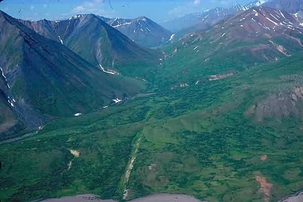
Alaska is a late addition to North America. That is true politically, with the purchase from Russia in 1867. At the time Russia was recovering from the Crimean war and it was expected that in any resumption of hostilities Britain would capture Alaska. That prospect alarmed both Russia and the USA, so the purchase suited them both. How little times have changed, with another Crimean war and a North Atlantic trade war in progress! The geology of Alaska also derived from Asia. The land was build up north to south. 400 million years ago, the sea between the Pacific and the Arctic ocean was shallow, an extension of an older mountain range reduced to small islands and submerged land. Over the next two hundred million years, a tectonic plate drifted north and hit the shallows. This collision formed the Brooks mountain range 150 million years ago, and it largely closed off the connection between the Pacific and the Arctic ocean. Later, a new plate fragment hit, and the White Mountains formed in the same way, separated from Brooks by the Yukon valley. Finally, the Alaskan range formed when the current Pacific plate began to subduct underneath the young continent.

Brooks mountain range, seen from the coastal plain, north Alaska
Faulty plates
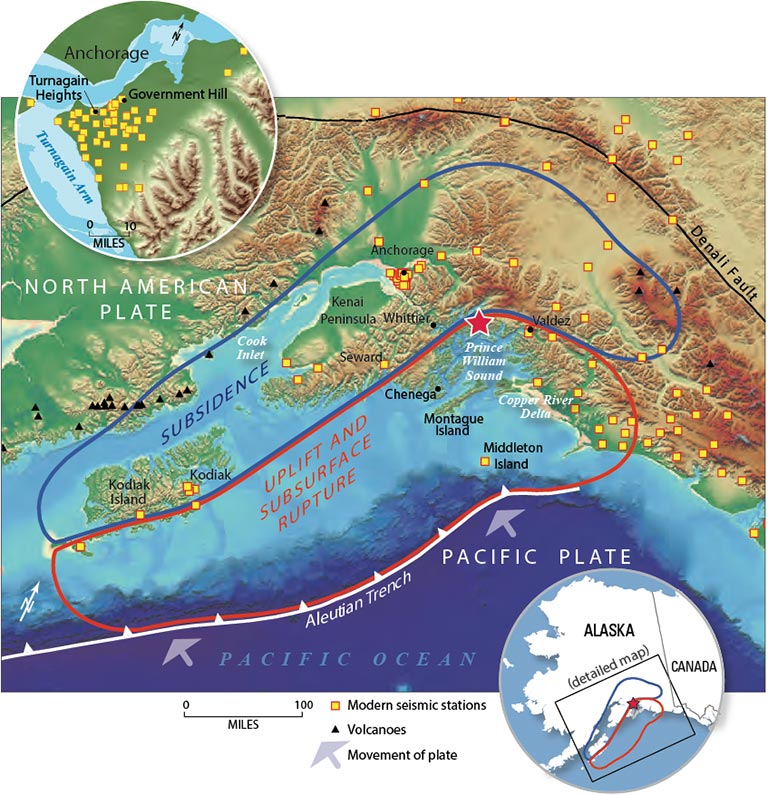
Of the faults the riddle Alaska, best known is the subduction trench. The Pacific plate is moving north at about 5 cm per year. As it sinks, it forms the Aleutian trench which runs from Alaska to Russia.

The image shows how the process works. The Pacific plate comes in from the right (south). As it arrives, a cover of accreted rock is scraped off and left behind, pushed up against the continent. This is fairly weak rock with many fault lines. These are called ‘splay faults’ because the stress of a single fault system is spread over many individual faults. Montague island, off the coast of Alaska, formed this way. Further along, an area of subsidence forms. Finally, the subducted plate meets the much stronger rock of the true continent and slides underneath.

The zone between the two plates, where the continent slides over the subducting oceanic floor, is where the major earthquakes occur. The events are often close to the trench, but along the Alaskan coast they also occur further north: the angle of subduction is not as steep here as it is further west along the Aleutian arc. Note how the trench peters out south of the Cook Inlet, also an indication of the shallower subduction. In Alaska, the subduction is less about sinking ocean floor and more being overridden by the lower-density rock of Alaska. The line of Alaskan volcanoes ends at Cook Inlet, and doesn’t resume until near Canada, with the enigmatic Wrangell volcanic field. This is called the Denali volcanic gap. Everything is connected: the missing trench, the shallow subduction and the missing volcanoes. What is missing is the cause. The suggestion is that the oceanic crust here comes from an oceanic plateau, which formed in the Pacific and drifted north where it met Alaska. The plateau is much thicker than usual oceanic crust, at 20 kilometers. This thickened slab is called the Yakutat crust, and it currently lies underneath the area west and north of Anchorage.

From Martin-Shoert et al 2016, Subduction geometry beneath south central Alaska and its relationship to volcanism. The black line indicates the extent of the subducted Yakutat crust.
The oceanic slab descend at an angle of 30 degrees until it reaches 100 km in depth, after which it goes down much steeper to 400 kilometers. The Alaskan Range, the mountain range that includes Denali, forms an arc where this subducted slab descends steeply; the mountains are pushed up by the buoyant oceanic plateau. Alaska is a well squeezed place.
There is a second fault that is important. The Denali fault follows the arc of the Alaskan Range. Movement along this fault is limited to about 1 cm per year westward. But it builds up a lot of stress. On November 3, 2002, one of the the largest on-land earthquakes known in North America happened here, when 220 kilometers of the fault ruptured in an M7.9 event. The Denali fault has a large bend in it, and Denali itself lies just south of this bend: perhaps the bunching of crust along this bend has pushed Denali to its extreme altitude.
The scarp of the Denali fault
In between the subduction trench and the Denali fault, a part of Alaska has become semi-separated from the North American plate. It forms the Wrangell sub-plate. Anchorage is in fact located on this sub-plate, connected to North America but not fully part of it. It seems fitting.
There are more faults here. In between Denali and the trench is the 200-km long Castle Mountain fault, which runs north of the Cook Inlet: part of it is visible as a scarp on the surface. In 2007, a report came out showing evidence that earthquakes occur on this fault abut every 700 years, with the last one 650 years ago. The authors predicted that an event of M6 to M7 would be possible on this fault in the next century. There are other faults in the area, such as the Border ranges fault which runs east of Anchorage.

The region shows a complex structure, with a major fault through the mountains, shallow faults running parallel to it, and a subducting plate underneath. Each one of the faults and boundaries is subject to earthquakes. Is it a wonder that shaking here is frequent?
A shaken history

M7.0+ earthquakes since 1900. The orange circle is the November 2018 event, and the blue one depicts Jan 2018.
A map of major earthquakes around southern Alaska shows that most of them occur towards the Aleutian arc, and are in between the coastal mountains and the subduction trench. The trend picks up again along the North American continent, were the major events closely cluster around the main fault. In between, things are much more complex. Here, some events occured within the Gulf of Alaska, showing the stress in the oceanic plateau. Two events were near the Denali fault, and four were in-land along the Cook Inlet and the Prince William Sound. Things are far less predictable here.

The map above shows the largest earthquakes in the Cook Inlet area over the past century. Two are on the Denali fault (1912 and 2002); the others are distributed around the area. There is no obvious connection to the known faults in the area: either the earthquakes come from faults that are not visible on the surface, or (more likely for large events) they occur on the frictioned surface between the continental crust and the subducting plate.

Plot the M5.5+ earthquakes, and a bit more of a pattern appears. Some follow the Denali fault. Others are the in middle of the Cook Inlet. There is a cluster on the west side of the Cook Inlet, and a few follow the Castle Mountain fault.
The depths are also clustered. The Denali earthquakes are around 5-20 kilometers deep although two are at 130 kilometers. The ones near Anchorage are around 30-60 kilometers and at the top of the Inlet they are mostly around 100 kilometers deep. There are few strong earthquakes in the upper crust: most earthquakes trace the descending slab. The subducting plate lies about 40 kilometer below Anchorage where it is much shallower than around the top of the Cook Inlet. The earthquakes caused by the subducting plate are thrust quakes.
The land region around Anchorage, including Denali, has around one M6.5+ earthquake per decade. All these quakes would have been major disasters anywhere else in the world. But Anchorage is build to cope. It has experience. It may be shaken – but not stirred.
The great quake of 1964
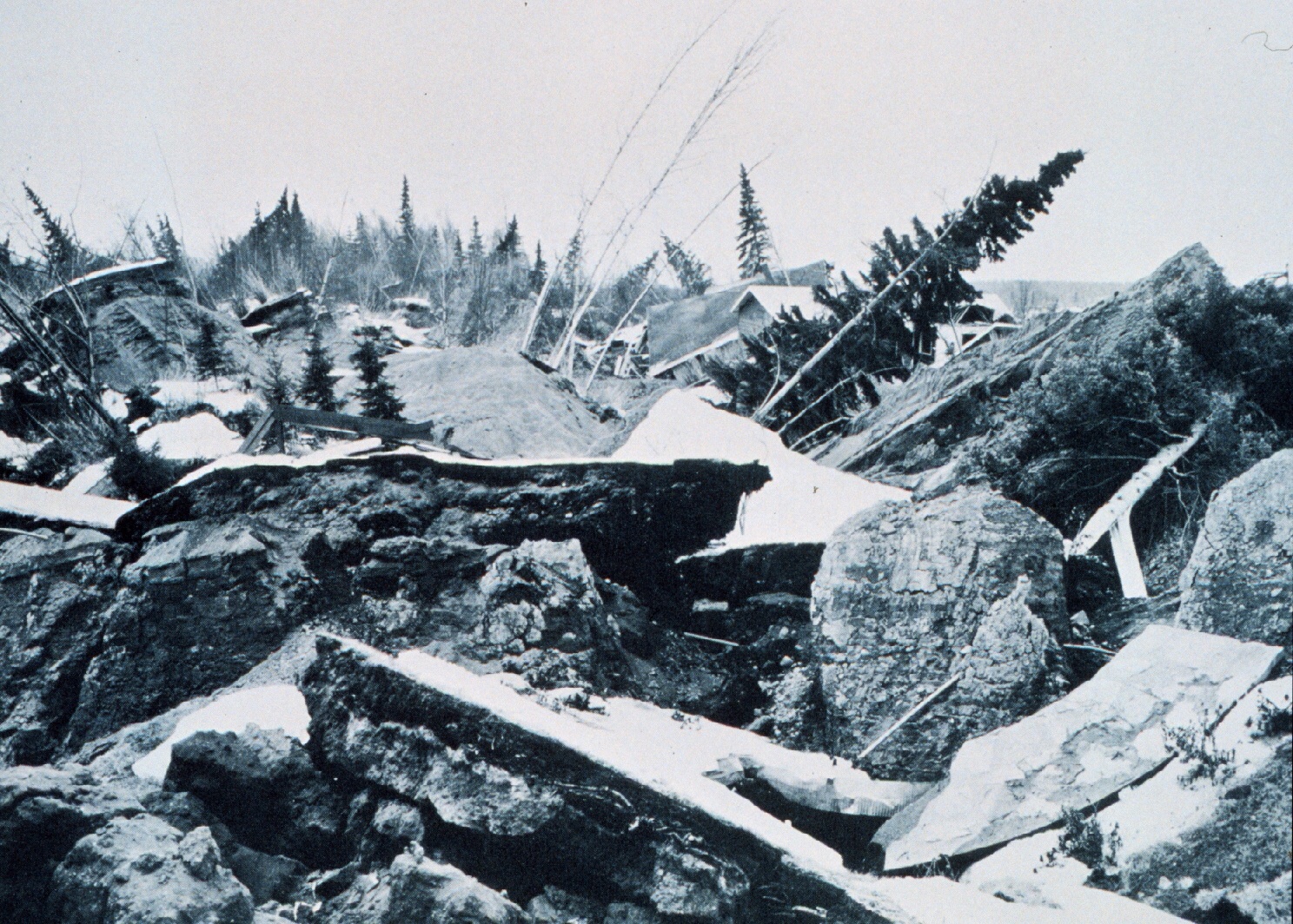
But one of the earthquakes was too much even for Anchorage. The stress had build up for a long time. The process was the same as the thrust earthquake described above. The subducting Pacific plate had gotten caught by the plate above. Friction kept the two locked underneath Anchorage. In this situation, the subducting plate keeps moving: it has little choice, with the whole mass of the Pacific behind it. So the continental crust, locked in place, was pulled down with it. The effect was that the south side of Anchorage was being pulled down and the northern side pushed up. This had happened over many years, so people were not aware of the slowly changing landscape. Until, on March 27, 1964, at 5:36pm local time, 25-kilometer below the surface, the connection between the two plates gave way. Over the next 4.5 minute, Alaska snapped back into place. The result was the largest earthquake ever measured in the US, and the second largest known worldwide. The magnitude of the event was a staggering 9.2.

1964. The similarity to the photos from the 2018 earthquake is striking.
Thrust earthquakes of this size are called mega-thrusts. There is no strict definition, but a usable one is to call a thrust quake of M8+ a mega-thrust. What causes a thrust quake to reach this size? That is not fully known. The speed of the subducting plate is obviously a factor. So is the subduction angle: shallower subduction gives rise to stronger thrust quakes. In fact, this mechanism is the only one that can produce earthquakes this size, so all M8+ earthquakes are mega-thrusts. Five earthquakes of M9+ have been recorded in history: Kamchatka 1952, Chile 1960, Alaska 1964, Sumatra 2004 and Japan in 2011. Casualties ranged from an estimated 5,000 for the Chilean earthquake to 250,000 for Sumatra. In this list, the Alaskan quake is exceptional for the very low number of people who lost their lives, 131. Many of the casualties were in the coastal village of Chenega which lost a quarter of its population from the tsunami. At the airport, a controller died when the tower collapsed. But in view of the extreme size, the remarkably low number shows how well prepared Alaska is.
Still, the effects were severe. In four minutes, a century of deformation was undone. The area to the south, which had been pulled down, was uplifted: the highest uplift was close to 15 meter. The subsidence along the sound was less, but still over 2 meters in places. A tsunami formed with a highest run-up height of 65 meters. The wave reached as far as Hawaii. The worst local effects were from the multiple landslides.
2018
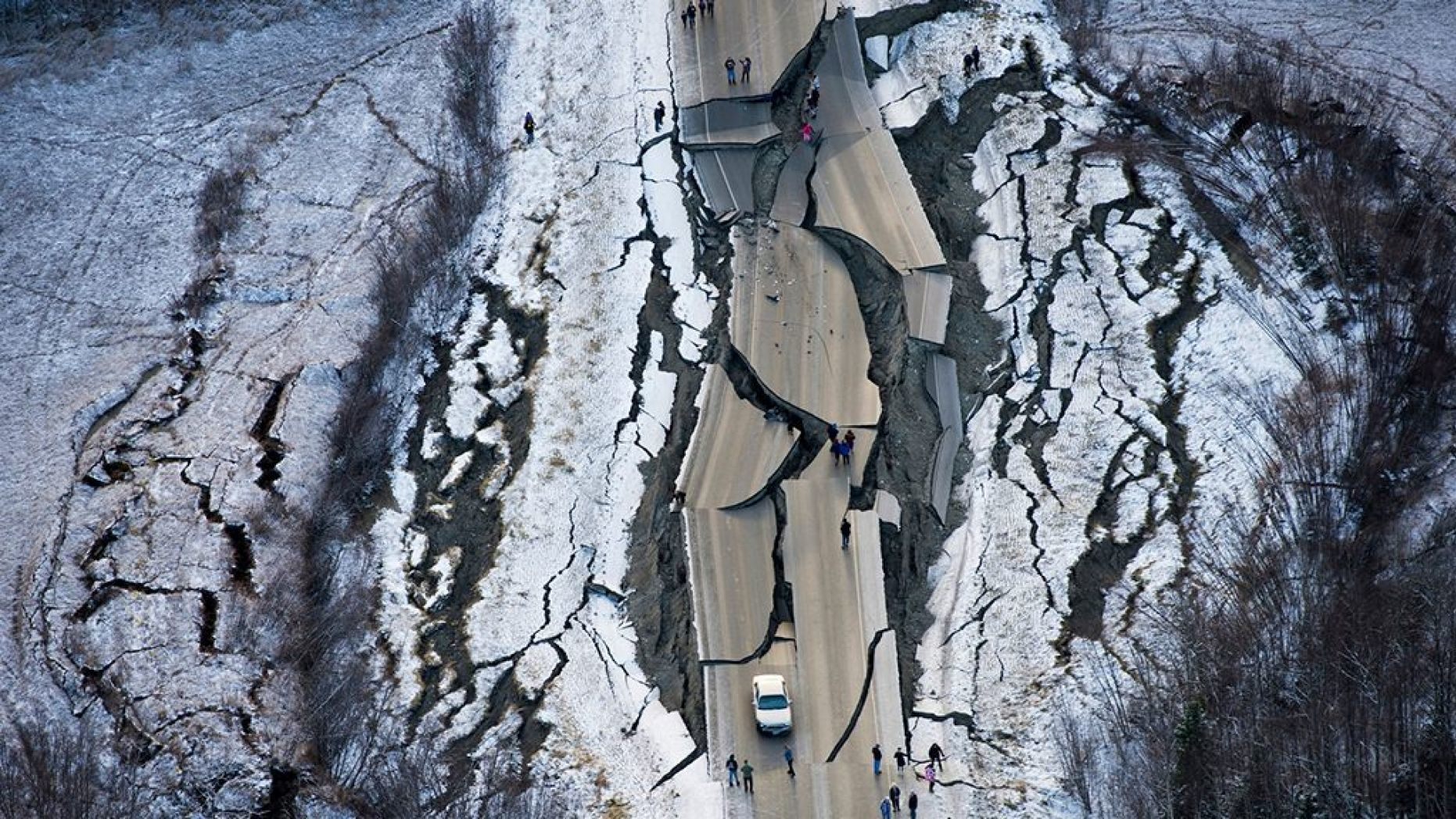
The Anchorage earthquake occurred in the early morning of 30 November 2018. In hindsight, it began on Jan 5, 2018 when an M7.5 hit off the coast of Canada. This is in itself not that unusual. However, it was followed by an M7.9 earthquake off the Alaskan coast, which occurred on 23 Jan. Were the two events related? They seem far apart for that, but such a quick succession of major earthquakes is unusual, even here. One may have triggered the other if it was already primed to go.
And on Nov 30, the earth just north of Anchorage shook when the locking of the continental and subducting plate failed. It was recorded at M7.0, minor compared to 1964 but massive on any other scale. A link between the January and November events seems speculative. However, there were months of minor earthquakes in the general area since the summer of 2018. It seems plausible that the January event transferred some stress, and that the area was already prone to slipping. The minor quakes were a danger sign, warning that a larger quake was coming. Foreshock events here are not uncommon. The M7.9 earthquake in 2002 was preceded by an M6.7 earthquake which occurred 10 days earlier.
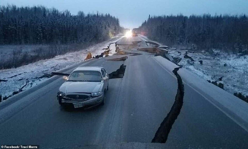
Initial reports suggests that the damage from the 30 November earthquake is remarkably limited. Some damage to some buildings was mentioned, and some roads, specifically Glenn Highway, Vine Road and Minnesota Drive, are badly cracked, possibly affected by liquefaction. The damage is estimated as over 100 million dollar. For such an event, that seems very low. But no matter how well prepared the area is, for people in it is a terrifying experience, made worse by the aftershocks.
The 2018 earthquake happened at almost the same location as the great 1943 earthquake, which coincidentally also was in November but was much stronger at M7.6. The depth of 40 kilometer makes it a thrust quake, with the same process as the 1964 mega-thrust but much smaller. As I write this, the aftershocks are still continuing, at depths of 20-40 kilometers. The aftershocks are all north of the main event, between the Inlet and the Castle Mountain fault. But it hasn’t triggered any movement on the latter fault which is a good thing given the possibility that it may be close to its own event. In any case, typically the largest aftershock is one magnitude less than the main one. The largest aftershock so far is less than that, and so it is possible that there will be another M6 quake in the next few days.

What next?
Normally, a quake this size resolves the stress for quite some time. The repeat time can be hundreds of years or longer. But not here where M7-size quakes seem a dime a dozen. And some earthquakes of this size in Anchorage come in pairs, around 10 years apart. This happened in 1899 and 1909, (a further event in 1912 was near the Denali fault), and in 1934 and 1943. After the 1964 mega-thrust, it was almost 20 years before there was another M6.5 thrust, in 1983. And now, 35 years later, we have had the next thrust. (A few earthquakes of similar size in between were either much deeper or much shallower, and of different type). Before 1964, there had been 11 thrust earthquakes M6.5 or larger over 50 years, or two per decade. After 1964, there were 2 over 50 years. It shows how quiet things became.
So what is next? Have the quiet times after 1964 come to an end? If so, we can expect such thrust quakes to become more frequent. The next one will not be 35 years away but may well be within 1 or 2 decades. But whatever happens, Alaska is remarkably well prepared. It will manage. It knows that the beauty of this land of sea, mountains and volcanoes is build on broken ground. It is part of the package.
Albert, December 2018


Hahaha : ) soon the Xenomorphs will find the InSight probe : )
A facehugger will attack the seismometers and adult Xenomorphs will pull up the thermal mole digger and break it to pieces. They will turn over InSight and rip out the electronics
Its me being silly minded
In the UK newspaper “The Times” (page 32) today (Monday 3/12/18) there is a short article on Mount Paektu in North Korea. I don’t know how accurate it all is, but James Hammond of Birkbeck Uni (senior lecturer geophysics) recommends it needs closer study to learn its history. The low level activity under it in 2002-2005 apparently caused some interest. North Korean scientists are trying to get a better seismic network around it, but are limited by sanctions. Naturally (being a newspaper) the theme of the article is the usual: volcano explodes bigger than all the rest and we’ll all suffer terribly…etc. etc.
I can’t give a link because I refuse to fork out my entire pension on the mountainous subscription cost to this rag (so I subscribe to a rival). But for those of you who can access it, might make a slight diversion from Mars, Moon, and the looming threat of Iceland turning into a cinema popcorn fryer….
“…Naturally (being a newspaper) the theme of the article is the usual: volcano explodes bigger than all the rest and we’ll all suffer terribly…”
Alas, it’s the usual way with the UK press but in this instance, the location of Mount Paektu does have some added implications……
Well, it is quite an interesting volcano, both from its capability for destruction as well as location both politically and geologically
there was an article not so long ago, that they have a bi partisan agreement between North Korea/China/USA because it will effect everybody as a reason, can’t remember where and when
“bi partisan” with three players? Strange…
No frost quakes!!!
If there would be frost quakes, why they would be always in the volcanoes and not in the rest of Iceland?
Those were Hekla quakes!!!
Let’s see whether they change with the weather. I do note that three surface quakes have made the IMO daily list, which should be clear of ice/frost quakes.
“why they would be always in the volcanoes”
Because they stick higher up into the atmosphere?
Plus the ground is very permeable and lets the water in. And maybe even more importantly, it’s around the volcanoes that we have the most sensitive detection equipment.
Lots of earthquakes in the Grimsvötn system now and Thordarhyrna and iced part of skaftar rift
Little swarm going on just southeast of Langjökull. Not sure if that even has any significance .
Regarding the swarm SE of Langjokull:
This has been an area where I think its IMPORTANT to pay attention to. This area has shown repeatedly deep swarms on a regular basis. But not regular enough to call attention of the people here. But this is how things start.
This is how Oraefajokull was starting two years ago when I was calling attention to it, despite that the situation was being ignored by everyone else. And why I did I paid attention to? Because it was the case of a non-seismic region suddenly experience occasional deep swarms, which points to magmatic intrusions in a known volcanic system.
Langjokull is a major volcanic system and it is active and capable of massive eruptions.
Most people here are unaware of that fact.
Langjokull ice cap experienced the last shield eruption of Iceland about 1000 years ago. Iceland was already populated. It was a very large eruption.
The region has been quite non-seismic but has started to experience deep swarms since the past few years. And activity is increasing there. So I think its worth following the region. If swarms become more regular, then the region may be heading to an eruption.
Such eruption will not happen before the collapse of the UK government however (political joke), which seems to be likely to occur within the next few weeks. But Hekla may certainly erupt before that!
Caldera formation in the UK government seems more likely than not as this point. Rifts are growing and the shaking is increasing. And there is pressure from Mauna Europe, Mons Putin and Mount St Trump. Things are bleak. But at least parliamentary discussions are still civilised and the eruption is most likely effusive rather than
imexplosive. The 1930-like language has receded after the backlash.I refuse to comment due to the the probability of pissing off a whole lot of people.
It doens’t matter what side I favor, someone is gonna be angry with it. THAT is a virtual certainty.
This is the point at which Carl’s “Be Nice” policy is very applicable. I have found that my ability to ruffle feathers is quite profound.
However, it is quite refreshing to see that our government is not the only one containing functional idiots. (Pick a side, it doesn’t matter)
And on a US centric point of view. The comedian “Gallagher” made note that a “Con” is the opposite of a “Pro” … so does that mean that CONgress is the opposite of PROgress?
Don’t worry – it looks a good political eruption no matter which side you favour. As with any build up to an eruption, it could still fizzle out. But there is notable tremor.
Not intending to make light of it, but I am enjoying the show.
I might have an issue with the word ‘functional’ ..
Dis-functional can be substituted as desired.
UK Government. It’s certainly a cringe-worthy scene. It’s like an ongoing exchange of tephra, clinker, and the odd phreatic explosion, as the whole edifice subsides into the caldera in a pall of ash. An embarrassment of volcanic proportions.
And yet everyone is watching the Summit Peak of a possible HouseofCommons eurption or calerda forming event. The bigger picture is more bleak with Cork, Dublin & Belfast directly in the firing line of any pyroclastic flows, lava boms, and toxic gas should the volcanic-economic models play out. These events will have a significant inter-island effect.
Just substitute the word “idiocy” for the word “magma”…..
“The system is well-primed and highly pressurised, but the intrusion of fresh magma continues unabated. There is now a certain inevitability to it. Magma is going to reach the surface and all hell will let loose… very soon”
Guess it’s a race then, since the Belgian government is also more than preparing for a full on flank collapse… Any guesses which one will fall first?
Martians are getting wiped out!
Lucky shot of a Perseid lining up with Mars, full credit to u/K1ngKarma over at https://www.reddit.com/r/astrophotography
Original thread link https://www.reddit.com/r/astrophotography/comments/96xot2/perseid_and_mars/
Cooool! That’s a great photo ta catch.
On a similar thread – i.e. the discussion about the angular rock/meteorite in the Mars Insight photo. My eyes are not what they were, but to me it does seem that the object may be sat in it’s own small depression. Could such a depression have been made by a meteorite recently hitting the surface at free fall velocity? I suppose other options are wind (or the landing thrusters of Mars insight) removing light material around the rock.
Burning stream of plasma as space rock enters earths atmosphere.
the entry plasma itself is as hot as the surface of the sun 5500 C
Huge deacceleration and pressure and temperatures often explode spacerocks as they comes in an airburst.
Human space capsules are blunt and rounded to keep away the 5500 c plasma from toucthing the spacecraft. Reentry capslules are insulated with heat shields. The plasma may not toucth the reentry craft but it still get very very hot 1700 C.at the surface. Sillica foam and ablative cheramics are often used as heatshields.
Ablative coatings can be quite handy.
This is just an SM-2. The ER versions we carried had an additional booster that required a 4″ circular pad of the coating under the launcher to keep from damaging the decking. I’ve gone out and looked at the area around the launcher after a launch and noted that much of the un-shielded metal structures were stripped clean of all paint. You could even see shadow outlines of cleats and other small obstructions where the deck combing was shielded from the exhaust blast. Oh, and it will flat-out melt a stokes stretcher. (The medical dept failed to remove it from its bracket prior to the exercise shoot.)
http://webcams.volcanodiscovery.com/ Check Erta Ale space thermal cam
The Erta Ale flank eruption continues to feed lava through a very very well established lava tube system
For now almost 2 years its been going constantly the lava tube system is 16 km long.
Active pahoehohe lava flows are expanding in the salt deserts.
Maybe around 0,2km3 have been erupted so far and pretty impressive.
Erta Ale is a small young shield volcano in the afar tripple junction hotspot boundary.
The lavas there are Thoelites signs that partial melting is increasing and the litopshere gotten very thin.
This lava tube flank eruption coud last for years.
It already has lasted for years 😉
Is there any official numbers for the age and volume of erta ale? It is pretty substantial I think around 700 meters high and while it isn’t only one volcano in that area I think nearly all of those volcanoes are mostly Holocene. It is really hard to tell with it being a desert though.
Still, erta ale seems to have quite an impressive effusion rate, not as high as kilauea but around 3 m3/s is what I have heard, which is about half kilaueas supply so this eruption could indeed be 0.2 km3, probably even 0.3 km3.
It is interesting that the 3 areas where large shield forming eruptions are most common are all in polar opposite climates, Iceland lives up to its name, afar is a desert, and Hawaii is a subtropical/temperate rainforest. Very interesting. Political reasons do make things difficult to observe them too, quite obviously in most of Africa, but Hawaii has recently joined in on that front…
I think the recent eruption from erta ale wasn’t a shallow lateral eruption either, I think it was a direct eruption up from the magma chamber and that everything is just really well connected so the lava lake dropped from lack of pressure during the initial drain. The original lava lake hasn’t really changed much apart from the early 2017 events, so the new shield that is forming is probably not directly fed from it. People dint go there very often though to make observations so it’s all speculation at this point still.
Maybe in 50 years there will be a new large shield there, pu’u o’o is almost 100 meters tall, some Iceland shields are hundreds of meters tall. Maybe in 50 years it will also be safe to visit, and be on an island, if the danakil depression floods.
Erta Ale is an excellent example of fluid hawaiian slow Puu Oo like action outside hawaii itself. As you says… Erta Ale is likley very very young and most likley entirely a holocene structure. These tube and pahoehoe flows is how these shields and Hawaiian shields grows
only diffrence is that Erta Ale is tiny compared to the immense Hawaiian Deep sea giants
The Etiopia – Eriteria conflict have ended : )
Now its more safe to visit Erta Ale
Still the Afar Triangle haves an awful climate
Summers are impossible and winters are barely copeable for us polar residents IF we wants to visit Erta Ale. Still insane heat and sun that does murder to my skinn.. is better than this awful Sweden winter.. Im freezing
I wants to visit Erta Ale one day: It will be a winter then
I needs to get used to oven like temps and dehydration.
Still i likes a hot climate.. better than this cold Im stuck in
Erta Ale is quite extended.. its quite large but not very massive
Erta Ales volume coud be some few 100 s of km3. Maybe 200km3?
The volcano is likley very very young. The Afar plume is getting though the continetal crust in that rift and erupts as hot hawaiian looking thoelites
I just looked at it, erta ale is about 700 meters tall and has an area of also about 700 km2. This is pretty vague but a cone that has that measurement has a volume of 165 billion m3, or 165 km3. Assuming erta ale is erupting at a base rate of 3 m3/s, it would erupt about 260,000 m3/day, or about 95 million m3/year. At this rate erta ale could only be 1737 years old. I think it is actually way older than that though, because the volcano would be overflowing all the time if it had that rate, but it actually has only had active lava effusion twice in the past 50 years, in 1977 and 2017-now, so I think either erta ale is much less voluminous and built on older volcanoes, or it is a very young volcano that might have largely been built in one episode, a modern day skjalbreidur.
Maybe that has ended with its caldera forming, likely a very recent event of the past 200 years that was similar to pu’u o’os collapse this year as there is a lot of brown ash around its summit just like at pu’u o’o, and last year another shield building episode started next to it and will eventually resemble it in a few decades or centuries.
I also found that there was a similar flow to this year at some point pretty recently, it is rather a lot smaller than the current flow but it shows that maybe events like this year shouldnt be unexpected. The green dot is the location of that flows main vent, and the orange dots are the lava lake and current flank vent.
Actually skjaldbreidur is similar prominence as erta ale, 550 vs 700 meters, but not as extensive and erta ale is flatter, but otherwise this is probably a pretty good comparison. I think erta ale has probably not really stopped erupting since it formed.
I guess Iceland did have its own version of erta ale at one point, actually a few times and maybe even at the same time if these shields stay active for centuries.
On this same idea, rangitoto island in the Auckland volcanic field has been found to actually be polygenetic, with the first eruptions 3000 years ago, and being fairly regular since then. The last eruption was about 500 years ago, and was similar to pu’u o’o.
The island might still erupt again, which would be better than an eruption in the bay or within the city. It also removes the apparent dormancy between the previous eruption (mt wellington 8000 years ago) and the rangitoto erutpion (previously thought to be only 600 years ago.
There are quite a lot of shield volcanoes that are very interesting and often ignored because they are not as clickbaity or worthy of a headline after kilaueas eruption this year.
There are two other very young pahoehoe fields north of the summit, one of them is very extensive and seems comparable in size to the ongoing event, it also had some more intense phases that produced aa flows.
I find amazing how the arid climate conserves the morphologies of past eruptions so well, in Iceland ice and water rapidly alter the flows and in Kilauea a thick vegetion cover develops in about 200 years. The volcanoes of Afar show many different morphologies resulting from effusive eruptions and in a good state of conservation. In Alayta wide perched channels and enormous lava ponds. In the Alu-Dalafilla complex a cone that has slumped inwards and from the looks of it was formed through intense high lava fountaining feeding an extensive flow field of multiple big aa flows, seems to me like this was Afar’s version of Kilauea Iki, but without the big pond. The 2008 eruption of Alu-Dalafilla was also quite big and would have been an spectacular one to watch.
Yes the other young flow (the smaller one at the top left of the picture) formed in 1973. The other one is not known, but probably less than 200 years ago like the flow I outlined. None of these flows have sand on them, which probably starts after maybe 200 years like you found a while ago.
The current flow is probably the biggest one though, the shield at the vent is in the 10s of meters thick already, and several times the eruption has intensified including a several km long channelised a’a flow in mid 2017. Eventually the lava tube will break down and probably fill in that caldera more, I think the longest lived tubes at kilauea lasted about 3 years but the lava on kilauea might have been a bit hotter (just a guess though) and was probably a fair higher rate of effusion, and was on steep slopes in most cases, so that would tend to destroy the tubes quicker.
I imagines often an Artic Erta Ale in Iceland just north of vatnajökull.
Constantly active with lava lakes and pahoehoe flows and tubes.
Visitors visits often in trucks and offroad to poke pahoehoe lava flows thats spreading over the landscapes. The lava fields covers mouch of the North Rifft Zone. During summer in Iceland souch an long lived event woud be a huge tourist magnet to poke lava and watch the lava lake and flows. The glow from the eruptions and aurorae woud be amazing.
That volcano if it happens in Iceland woud draw tourists like mad.
Iceland is the worlds 2th strongest hotspot and it can certainly do an Erta Ale. The most likley places for souch an event is just north of vatnajökull
or inside vatnajökull or the Dead Zone.
But a open conduit is needed too
Remember the sulfur. It would be very unhealthy and tourists would be kept far away. In the worst case, cities would have to be abandoned due to deadly air.
Albert this is a slow shield building eruption
with very low eruptive rates. The sulfur output is small
Souch an eruption woud be a huge tourist magnet in Iceland
irpsit = you knows Iceland very well: whats the largest effusive lava flow eruption and explosive eruption Iceland is theoreticaly capable of doing? Carl says an 150km3 effusive flood eruption is not impossible.
If that happens its crazy… but as Carl says its a once every 270 000 years event or rarer.
And in the Flood Basalt world even 150km3 as a single event is tiny.
Since Iceland is a very powerful hotspot combined with a slow ridge.. I have always pondered its maxium capabilities. Of course we do not want.. Iceland as its max powers.. very bad gas and ash pollution
Near Husavik there is a mini flood basalt sequence thats quite young I think. Close to holocene rocks.
When Iceland does these stuff its when the Iceland underground Balrogs is having rock Hallelujah party
I think such a large flood basalt in Iceland is only possible if it happens in the ocean, at considerable depth. On land, the vertical mass to support such a flow is not there. Looking from below water, Iceland becomes much taller and bigger and more becomes possible. But the eastern rift zone does not currently extend into the ocean. Therefore, not now.
[redacted, see below] → 22:00 comment by Jesper Sandberg.
As long as the hotspot and mid ocean ridge cross eachother
Iceland will grow larger and larger.. growing from the middle.
correct written here
https://www.volcanocafe.org/fingered-by-the-plume/
This is a great article about the Iceland Hotspot and Plume
It suggests that the Iceland hotspot is growing more powerful over time.
The Mantle Plume haves an odd shape like an octopus with many arms too
https://www.newscientist.com/article/2129216-strange-mantle-plume-under-iceland-helps-keep-scotland-afloat/ Another article about this Iceland Plume… this is old and already debated stuff on VC
The only problem is that despite what some US Congressmen think, islands do not “float” … at least in relation to water. On the asthenosphere, yeah, that’s workable.
Ummagumma
There was a 7.6 magnetude earthquake in the South Pacific near New Caledonia. A tsunami threat has been issued
It was a shallow one too at aroun 10km
Waves are currently hitting New Caledonia. https://www.tsunami.gov/events/PHEB/2018/12/05/18339001/4/WEPA40/WEPA40.txt
Shows up on the Hekla borehole strain? A nice little jolt at about that time. Must have rung around the globe like a bell. Not sure about this but can’t think what else it would be.
New Madrid may not be as ominous as we have been lead to believe.
“…found they corresponded to previously identified earthquakes that occurred on the Reelfoot fault: 1812 AD, ~1450 AD, ~900 AD, and ~2300 BC. Importantly, they didn’t find evidence for any additional earthquakes in the interval from ~4,300 to ~11,000 years ago. If the earthquake record preserved in the sackung is complete, “our record confirms that the tempo of earthquakes hasn’t been sustained,” says Gold.”
They trenched as least as deep as the Peoria loess, an 11,000 year horizon.
Read more at: https://phys.org/news/2018-11-punctuated-earthquakes-madrid-area-uncovers.html#jCp
I see that the Pu’O’o eruption has been declared over by HVO, after the interruption reached three months yesterday. Kilauea is now officially dormant/inactive/not-erupting.
Technically by any other world standard, kilauea would still be regarded as active, in fact I don’t think there has been a time within the past 1000 years where it hasn’t been active. However by its standards this is about as close to dormant as kilauea will get most of the time. It may well be that mauna loa will erupt first before kilauea does anything else, but the chances are that it will be like the last eruptions where both volcanoes are co-eruptive even.
Also Jesper, in theory yes it would take that long to fill the space, but in practice it will probably take even less. The reason is that unlike any other eruption in this rifting episode, the summit physically collapsed, rather than just invisibly subsiding over a large area like in 1960 and 1975. In fact only the area relatively close to the summit actually sank downwards very much (more than a meter), and the collapse took up about 90% of the lost volume. Unlike passive deflation, the collapse is pretty permanent, and so despite the enormous size of this years eruption, the total amount of magma needed to fill the magma chamber to the same pressure it was in 2017 is much less than the eruption size would suggest compared to a passive drain like 1960.
After 1960 it took about a year to erupt, and 2 years to erupt on the rift again (interestingly the 1961 ERZ eruption was mainly around heiheiahulu, where activity is happening now), I think the next eruption will happen some point after late February next year, probably in around June-October 2019, likely in a place with fairly shallow magma, between mauna ulu and pu’u o’o, down to heiheiahulu. If it lasts much longer than that without doing anything then I think a pretty major eruption could result, in the 60s the rift was widening to accomodate the magma, so eruptions were small, but now there is so much magma in the rift that it could probably supply several large eruptions all on its own, and the rift can probably only expand so far before it is just easier to leak magma instead of slow intrusions. After only 2 years, in mid 2020, an eruption as big as 1960 or 1840 could happen, not that it will but it is a very real possibility. It would also quite likely involve high fountaining especially if near the ocean or high on the volcano somewhere, as there is no actively degassing vent anywhere leading to the same situation that preceded pu’u o’o and mauna ulu.
Poooooooooooor Puu Oo… iiits sneeeky he betrayed ussssss!
it betrayed ussss….Wicked… Tricksy, False.. Pele lied…. lied! ( Gollum )
RIP Puu Oo 1983 – 2018
Had the flank slip and summit – Puna intrusion never happened Puu Oo woud still be alive
Puu Oo was the ideal place for the eruption away from small town Big Island suburbs
Kilauea haves one of the worlds very highest magma inflows, at 0,2 or 0,3km3 every year it will only take 3 to 5 years to completely refill what was lost during the puna 2018 magma summit drainage
https://www.youtube.com/watch?v=2iEx-ZaIm-M
I loves this! Holuhrauns huge spatter rampart
getting washed with 1200 C lava
The spatter ramparts in Siberian Traps must have been like whole mountain ranges formed by high fountain fallout. Magnificent. Balrogs having pool party behind the wall of slag
I don’t know, maybe the deposits around the vents of flood basalt eruptions more than spatter were reticulites. The combination of both high fountains and strong atmospheric updraft would carry these reticulites exceptionally far from the vents, blanketing extensive areas with the greater thicknesses close to the source of the lava. The eruption would maybe switch into a more lava lake/dome fountains style at some point, unless the vent had opened in steep slopes.
I have seen those two main cone morphologies in basaltic fissure eruptions, the most common are spatter ramparts that result from small fountains and then there are the reticulite cones which form from very high fountains and usually when the output of the eruption is channelized through one vent or a short fissure, the resulting cone usually slumps inward and leaves a deformed structure (btw I think this might have happened to Puu Kaliu). It is also something usual to find cones made up of both spatter and reticulites, so a height of the fountain that is maybe half way between the two styles and I think usually shows at high rate eruptions with long rows of vents erupting at the same time.
I think fissure 8 is probably the best example of one of those cinder-spatter cones, it is made of reticulite from the high fountain stage and then spatter from after about June 8th. Fissure 8 was formed by fountains that peaked about 100 meters tall, and the cone is about 300 meters wide and was 50 meters tall above the surroundings (70 meters above the pre-eruption ground) at its peak, and now a bit more than 30 meters tall but a lot more massive looking. Baugur crater is also very similar, but a lot longer. I guess fountain height would produce a proportionally flatter cone with a greater height.
It is actually very striking how similar these eruptions were, even down to the eruption rate and style of the eruption. Holuhraun started out a lot more vigorously though, if that happened on kilauea immediately then the eruption would have been much more scary.
https://www.youtube.com/watch?v=EGhlBVpHymU
Journey to Mordor #Holuhraun
https://www.youtube.com/watch?v=kQYAEoQ1VQ0
Here is Holuhraun at peak strenght
The fountains 100 s of meters high
My favourite Holuhraun vid is the one of the tiny speck of light growing from nothing in the dark, caught on web cam. Brr!
Eldgosið i Holuhrauni
Utbrottet i Holuhraun
Le faʻalavelave i Holuhraun
Der Ausbruch in Holuhraun
الاندفاع في Holuhraun
L’éruption à Holuhraun
Holuhraunen erupzioa
La erupción en Holuhraun
Udbruddet i Holuhraun
D’Eruptioun an Holuhraun
Holuhraun’daki patlama
The whole world and many more watched this awsome show.
Holuhraun became one of the very largest effusive at once eruptions in my lifetime so far.
De eruptie van Holuhraun kan er ook nogwel bij. Well. It’s Dutch.
*De uitbarsting van Holuhraun
That is even better!
“irpsit = you knows Iceland very well: whats the largest effusive lava flow eruption and explosive eruption Iceland is theoreticaly capable of doing? Carl says an 150km3 effusive flood eruption is not impossible.
If that happens its crazy… but as Carl says its a once every 270 000 years event or rarer.
And in the Flood Basalt world even 150km3 as a single event is tiny.”
Jesper, in response to this: I do not think that flood basalt traps happen by themselves. I believe they are triggered by impact events. But this is just my hypothesis.
Iceland has done 30-40km3 of lava floods twice (or three times) since the Holocene:
Once in a fissure, in Veidivotn, a lava river that flowed 250km towards the sea
Once or twice as a shield volcano: Theistareykjarbunga, and maybe with Trolladyngja.
Iceland has also done a 30-40km3 (or even up to 100km3) explosive eruption in Torfajokull some few thousand years ago, and at the end of the ice age with Grimsvotn (that’s similar to Pinatubo, or even Krakatoa or Tambora size)
That seems to be the upper limit of Iceland is capable of doing.
At least I think the Siberian Traps and the Decan Traps were caused by impact events. I might be wrong however. The Colombia river flood basalt seems to be linked to Yellowstone hotspot.
I have adopted a different view of the anti-podal idea. I think that anti-podal impacts enhance active volcanic activity on the opposite side of the globe.
At one time, I thought that perhaps the Hawaiian hotspot was residual heat from a Siberian traps impactor, but this idea seems to have more going against it than support.
(even the Chixilub impactor would only make a transient crater to about 16.9 km)
Deccan traps started before the impact, and the biggest stage of the Deccan volcanism (western ghats, about 60% of the entire province) is concurrent with the loss of cretaceous fossils. The impact was not needed for the extinction, when the eruption rate during the peak is a sustained 1500 m3/s average over 13,000 years things are going to end badly, especially if the ruling animals are extra sensitive to SO2 like birds today. That last factor is something that is never considered in any study, but dinosaurs were probably uniquely ill suited to deal with such an event.
There is also no confirmed impact crater antipodal to the siberian traps, the wilkes land crater is not completely confirmed, and is not well dated, and anyway at that age it is very difficult to tell if they were associated.
The best idea is probably that large rifting flood basalts are caused by supercontinent breakup (not necessarily pangea-sized superdontinents), and the floods that arent caused by rifting are all on continents and so Deccan was probably caused by India overriding the reunion hotspot, and the buildup of magma caused a massive plume head to form which eventually melted through the continent. Otong java plateau might have been like Iceland but longer lived and maybe not as active so it never really surfaced (others might strongly disagree with me on that one though)
In a former time when I was a different person, I was interested in how the earth might look in the future, both the animals that could inhabit it, and how the continents move around, including my own idea on the next supercontinent. Apart from the popular pangea ultima hypothesis, other ideas have the pacific ocean closing. To do this, most maps show australia and zealandina moving u to collide with north america. Keeping in mind with everything I said in the paragraph above, if zealandia goes north through the pacific, it will override hawaii….
Its a bit of a stretch to assume hawaii will be as powerful as it is now in 50-100 million years time when this will probably happen, but if it is even half as powerful the plume head would probably raise zealandia from the depths again, and on top of it will be a flood basalt of enormous proportions.
We in Southern Africa also have our flood basalts. The uppermost layer of the Drakensberg Mountains, part of the Great Escarpment of Southern Africa consist of basaltic lavas laid down 180 million years ago during the breakup of Gondwana. These lavas covered most of Southern Africa and are possibly contiguous with the Deccan Trapps and flood basalts in eastern South America. The Lavas reach a thickness of 3000 ft along the Lesotho/ South Africa border, and individual flows can still be traced on the surface. They form part of one of the larger flood basalt episodes in geological history.
Deccan traps are late cretaceous over the K/Pg boundary, much younger.
Those flood basalts from 180 million years ago were very extensive and outcrop all through along Antarctica and southern Australia as well as south Africa and some of South America. There is a lot of intrusive dolerite where I live, it was formed at the same time and probably underneath a flood basalt. There is probably a lot of dolerite inside Iceland.
Imagine the very largest flood basalts
Like largest flows from Deccan and Siberian Traps and Opening of the Atlantic.
Souch individual flows coud have volumes of 5000 to 15 000km3 or larger!. This is a VEI 8+ effusive eruptions. In the most scary examples you can have fissures ( 300 to 600 km long ) Some old dykes in earths crust are many 100 s of kilometers long some over 1000 for old Canada LIP dyke swarm I think. These fissures with huge lava fountains roaring all over its lenght. Lava flow rates like the biggest jökulhlaup you can ever Imagine. Or countless broken hoover dams let loose at once.
The force of the fissures sent lava as high as 10 000 feet 3000 meters into the air
Curtians of blazing fire stretch across the horizon…
Beacuse major LIP flood basalts caused global warming and Mass Exctiontions
We can be pretty soure they went on very fast with collossal gas output.
and the media image of magmageddon is likley quite true.
Generaly true flood basalt lavas, are thick and uniform and massive: No lava tubes or small scale lobes: its fast and massive.
A true massive ( 1000km3+ ) flood basalt
Is likley a huge oversized channelized Aa flow
With fast smooth Leilani like lava channels
Flowing like mad crazy it must have done
In the largest chase these channels coud be many 100 s of km long and maybe 40 km wide. Some lava flows from Deccan Traps flowed 1500 kilometers from their vent sources.
The CAMP lava flow fields extended for over 5000 km over Pangea. It makes Holuhraun look like a little fart.
At the distant edges of the ( +1000km3 ) Roza and ( +11 000 km3 ) Rhajamundry flows you likley have a massive wall of Aa lava moving quite fast 40 meters high and with some mouch faster breakouts that happens at Aa edges
Or where the main flow front breaks thrugh the rubble.
Behind the flow fronts is the main flow and open lava channels that looks like a lava sea from Closeup. The open lava channels goes up to the vent rift systems far away.
The nightglow from these LIP events must soure been impressive red skies for 100 s / 1000 s of km photographers dream
The initial startup of a (+ 5000km3 ) flow must have been an impressive sight for soure if its in the fast model the start up itself may generate A few VEI 7 volumes of tephra.
I think its time for @Turtlebirdman to build me a timemachine
and let me visit Siberian Traps at peak days
Flood Basalts on the largest scale is an incredible sight
Major flood basalt armageddon are caused by HUGE mantle plumes
Often under supercontinets that insulates and overheats the mantle, or as large isolated hotspots.
Supercontinets that insulates and overheats the mantle tends to do the most scary plumes.
These come directly from the core and plume heads can be many thousands of kilometers across in largest cases. Souch plumes can also form under the large oceanic plates and form huge oceanic LIPS.
Large parts of the Earth bulges and domes upwards .. as the huge plume head lifts the litosphere thermaly.
Each of these huge plume events are acosiated with mass exctitions and climate chaos and continetal breakup and rifting of plates and formations of continetal and oceanic LIP s
Many hotspots may be born like this as powerful superplumes and they weaken over time.
Every time it happens, earth becomes sight of vitrual armageddon.
These huge lips can have volumes of tens of millions of km3 in very largest chases and be emplaced in less than 1 million years. I have always been thrilled by Flood Basalts ever since a small kid.
Imagine fissures many 100 s of kilometers long with lava fountains all across thats many kilometers high
Imagine huge seas of lava 100 s of kilometers wide and 100 s of meters deep and induvidual lava flows thats as large and longer than Scandiavia and UK. The Sulfur and Co2 from these are very bad indeed and as Albert says large parts of the continent or arera where it happens becomes poisoned and unlivable
https://www.youtube.com/watch?v=bA2afzgT1iM
Repost: This is a scary and creepy video, but fun anyway here is the HD version.
This shows the effects on todays world if an asteorid the size of Vesta hit Earth.
Thats an impact event thats 50 times larger than chicxulub.
The kinetic energy is so large thats its enough to boil away the oceans and melt earths uppermost crust. The world gets covered in 10 000 C rock vapour as the asteorid and a large part of earths mantle vaporize. This animation was done by geologists to see the effects if souch a scary thing happened today. The animation went viral on youtube many years ago.
Souch an event will fry the earth. Beautyfuly made anyway and great attention to details.
I love when the wall of rock vapour hits Himalaya, the snows and ice instantly evaporates.
Souch events only happened in the Hadean era when the earth formed
This animation is an old youtube classic and world famous.
Curious what woud happen if Vesta or Pallas hit earth? then watch this video
Here is the american version too: https://www.youtube.com/watch?v=PENT_hnyO-o
I think there is a bit of artistic licence in that video.
Starters for me would be the impacter. Why is it black and iridescent red (lava?) rather than the mundane dark dull grey you would expect with asteroids in general.
Another gripe is the inclusion of land marks like Big Ben. I presume it’s to allow the perception of scale but I’d have doubts that any archaic structure would still standing by the time the thermal shock front arrives.
Yep – Big Ben only needs a tourist to cough beside it for it to fall down. Much the same as the Houses of Parliament. They are all in desperate need of restoration. And the politicians inside them, too.
The motto was ‘strong and stable’ if I recall.
Try reading Neil Stephanson’s ‘Seven Eves’ for the ultimate nightmare, Jesper
Dunno, ‘Lucifer’s Hammer’ was pretty unnerving. And the specifics leading up to the impact were quite plausible.
Big ben woud not stand at all
The rock vapour shock front is 5700 C or much hotter than that
That will vaporize the building
Comment from the Administrators!
In Volcanocafé we love discussions and commenting.
But we have to make a request about grouping comments.
Lately we have had an inordinate amount of comments about the same subject ending up everywhere in the comments section. This make it harder for us to moderate, and it also makes the page slower for those trying to read all of the comments.
So, if you have already written a comment on the subject, write next comment in the same comment thread/tree. That will save a lot of space.
Obviously if there is a new article posted you can create a new Tree of comments in that article’s comment section.
It makes it a bit easier to find a coherent commenting thread on the subject for those interested, and it will make it easier for everyone to skip my eternal jabbering about Volcanic Walnuts (or some such).
Let us try this for a little while and we will see if it works out well!
/Staff
I know I have done a lot of that lately, but in my case there is a problem that sometimes when I click reply my text still ends up as a new comment. Might be that I’m not the only one having these problems.
We are looking into that, this is one of the reasons that we ask everyone to lump things together. It makes it easier for us to spot these problems and trouble shoot them.
Typically the thread tree “breaks” when a comment is deleted by one of us (for whatever reason) that someone responds to before it’s gone. The strange bit is that usually affects all commentors and not just one or two. If you ever see a comment that is devoid of text, that is the workaround we use. WP will spit out a luggie if a normal user tries to post an empty comment and won’t let that happen.
I’m pretty sure that’s not the problem in my case. All the times it has happened the comment I tried to reply to is still there. Sometimes I have replied to my own comment just seconds later to inform what I was actually replying to and that reply also ends up as a new comment.
Quite often, I start typing and then switch tabs to read an incoming chat message, google the correct spelling for some Icelandic volcano, or whatever, then return to finish the message. Could that be an issue? Then again, sometimes it happens just seconds later when I reply to my own comment…
Carl, would you consider a Friday quiz as in the good ol’ days? Maybe to be included in one of the upcoming posts? That would be a fantastic holiday present!
… and in keeping with my Bachelor Chow sub project…
Chocolate Chip cookies with peanut butter. → Better than a regular cracker and probably more nutritious than a Reese’s Cup.
No, I’m not a bachelor, but I’ve been one. The idea behind Bachelor Chow is a quick and easy meal/snack that isn’t necessarily meant to impress anyone, but will get you by.
Another example: Shrimp Ramen with cayenne, Old Bay Seasoning and Fillet Gumbo powder. Makes a nice quick personal Psuedo-Gumbo. Onion powder and/or Garlic can be added to round out the flavor. (The Old Bay seasoning contains celery powder so you are actually getting pretty close to all the constituents of an actual Gumbo)
https://volcanoes.usgs.gov/observatories/hvo/hvo_volcano_watch.html
Lots of info on kilauea from HVO, but that first paragraph is pretty interesting, HVO now directly states 1 km3 as the volume of the eruption, and that most of it ended up under water. The ratio between the volume and duration of the eruption technically makes the leilani eruption the biggest and fastest subaerial lava eruption on earth since the skaftar fires. Holuhraun was bigger overall but also lasted twice as long, but is less than twice the volume. This surprised me, holuhraun was much larger at the start and was also a much bigger vent.
I think that the SO2 flux from kilauea was also the highest number ever measured on an effusive volcano too, over 50,000 tons a day after fissure 8 started erupting deep sourced magma from below the summit.
That also brings the volume of the 1983-2018 eruption to about 10 km3. No other continuously active volcano on earth even comes slightly close to this, the only volcano that has comparable erupted volume in the past 40 years is pinatubo in 1991 at about 8 km3 DRE. It is true pinatubo did this mostly in a few hours but it also wont be repeating 1991 in 2026 either, or any time in the next 1000 years probably.
They state that 2/3rd went into the sea. So the land coverage is around 0.3 km3. Now some of the sea lava will actually be counted, namely where it raised the sea bed to above the water level. In particular, that was the case in the bay that was wiped out. Now if we assume that the same happened in historical eruptions in Puna, you should multiple the published volumes for old eruptions by around a factor of 2. I would guess that the factor is less for Pu’u’O’o as it was further from the sea and often did not reach the water. Conservatively we could take a factor of 1.5. Over the past 30 years, perhaps 6 km3, or 0.2km3 erupted lava per year. That is well above a sustainable rate. At some point, there will have to be a recovery phase.
But first you should look at what method HVO used in estimating the volume of the eruption cause if they have used measured rates x duration then there should be no volume lost into the sea. If the method was just calculating the subaerial volume and there were ocean entries then there is a lost volume.
0.2 km3 of lava per year is actually less than what it likely is in real life right now. I did some calculations a while ago. Kilauea was slowly deflating through the period between 1983 and 2006, but after that point it was at an equilibrium and didnt deflate anymore, yet the eruption continued unabated. The 2014-2016 june 27 flow is the only large flow which never had an ocean entry, and it erupted about 0.5 km3 of lava over a period of 2 years, which is 0.25 km3 per year. Even if I am overestimating the volume slightly it is still going to be roughly around that number. The volume of pu’u o’o is about 8.5 km3, the lava on the coastal plain is about 30 m thick and the lava above the pali is between 20 and 60 meters thick, on the grimsvotn article I went into it in more detail, but after 1955 the eruptions have been as follows:
1952 – 0.11 km3
1955 – 0.09 km3
1959 – 0.06 km3
1960 – 0.16 km3
1961-1969 – 0.2 km3?
1969-1974 (mauna ulu) – 1.2 km3
1975-1983 – 0.04 km3
1983-2018 (pu’u o’o) – 8.6 km3
2018 – 1 km3
1952-2018 – 10.41 km3 – 0.165 km3 per year average, but 1960s and 1975-1983 were very low eruption ratio so it is still around 0.2 km3 per year.
Really the fact pu’u o’o was able to persist beyond the end of summit deflation and not be significantly different afterwards (a bit lower rate but not a lot) is pretty evident to the prodigious supply rate of the Hawaii hotspot. It will take 2 years at most before kilauea erupts again at this rate, probably even less than 1 year before a small eruption happens.
Also yes, not every volcano watch article is maybe written the best, but that is actually the first time I have seen a straight up single value for this years eruption, I previously calculated it to be somewhere around 1 km3 but at the time the eruption was still going (late July) so the channel was thought to be shallower than it actually was and the then-accurate number was a fair bit lower.
Leilani eruption 1km3, 3 months
Holuhraun 1.5-2km3, 6 months
Both released 50.000 ton of SO2 per day.
That’s surprising.
Seeing the Leilani eruption on the TV and Holuhraun, it seems that Holuhraun was bigger and much more sulfur rich. But I would tend to believe these estimates.
They show both eruptions were similar in rate. Holuhraun lasting twice the time.
Holuhraun is about 12 meters thick on average, and 85 km2, so it would have a volume of 1.02 km3. It is probably more because it erupted on sand and some of the lava probably sank into the sand or even intruded at shallow depths both from the vent and as rootless intrusions from the lava flow, but I think holuhraun is probably still not more than 1.5 km3, it isnt 2 km3. It also lasted for 180 days, while kilaueas eruption lasted for 94 days, so kilaueas eruption was about twice as fast while being similar in volume.
Holuhraun probably erupted much more lava in its peak though, 300 meter tall fountains over a 1 km length of the fissure, compared to only two vents reaching near 100 meters for kilauea.
@Turtlebirdman
Holuhraun haves an estimated volume of around 1,4km3
The lava field is very thick here is a thickness map of Holuhraun
https://twitter.com/uni_iceland/status/560521097591140352
M majority is 20 meters or more thick.
Holuhraun is all massive Aa lava and just as Leilani it haves a huge channel system
1.4 km3 is what I have seen too, but that still means this years eruption on kilauea was the biggest lava eruption since the skaftar fires when you do volume x duration. Fissure 8 erupted probably 90% of the lava, so it’s eruption rate was probably about 40% higher than holuhraun averaged out, though holuhraun started much more vigorously.
It is also worth noting that late 2014 was the only time since 1983 that kilauea was not the worlds biggest natural heat source, it was still second on the list though.
Holuhraun was one of the hottest lavas ever phtographed in Iceland
1188 C to 1200 C very fluid and very gas rich it was.
This video shows the huge scale of Bagur!
Baugur is almost 500 meters long and 80 meters wide
The entrie vent was filled by 1200 C lava fountains and huge waves of lava and dome fountains when the eruption was going.
This video shows the huge scale of Baugur and the lovely colour of the lava
Freaking epic. The Icelandic Balrogs haves pool party in the vent
The colours are freaking amazing in that video!
My amazing colourvison is another reason I loves basaltic actvity so much
Erich Chengs videos of Holuhraun haves awsome colour, one of ther best colour on lava flows on all youtube videos
I dont know if a volcano watch article is the best source for the volume of the eruption though, remember the mess of an article that was released past summer with most or all the volumes wrong and confusing 1790 with Puu Kaliu…
I think you are probably correct. Many of the estimates discussed here are well reasoned and thought out. Why muddy the water?
Holuhraun was extremely gas rich
Extremely rich in sulfur and smell was felt in Norway according to this article:
http://www.ruv.is/frett/norwegians-smell-sulfur-from-holuhraun
I failed my Hekla prediction. Two weeks ago, a large swarm (for Hekla) affected the volcano.
I was predicting that it would erupt in the next two weeks, but this period has passed and nothing happened.
I guess one cannot rely in the same set of rules for Hekla anymore.
Nevertheless, I still stand that a swarm with a few earthquakes above M2 should result in an eruption.
The volcano is known to have a tendency to erupt January and April rather than at other times of the year, so we will be following it in the next few months.
All you have to do is turn your back on her and…kaboom! Like you, I think Hekla is our next Iceland eruption. I just wish Mila would fix that webcam…
I still say Grímsvötn. All the new instrumentation around Hekla makes us see things we couldn’t see before. As Irpsit says, when the quakes start to go into the M2 region it’s time to run. Until then, relax and watch all those quakes appearing around Vatnajökull that signal pressures at Grímsvötn approaching critical levels. Increased activity along the Loki ridge, Kverkfjöll, Þórðarhyrna and Kistufell are all signs that Grímsvötn is becoming ready. The CSM graph points straight up and soon it will go through the roof. My guess is before first day of summer.
I still have invisible pennies on Þórðarhyrna being next (I know it’s only an outside chance).
I’d love to see Þórðarhyrna go off… just to see how the papers deal with the thorn character. Probably substitute it to make it conform. But wouldn’t it be fun to see some bobblehead try to pronounce it as written?
That, or Þeistareykjarbunga. It’s not really harder to pronounce, but it’s longer and probably more intimidating :devil:
Perhaps UK rags would have to replace it with the Euro symbol…€ ….which is still on many UK keyboards, unlike Þ (and ð ).
Enough to create an eruption of its own in the UK!
Is this correct?
Grimsvötn maybe a trapdoor caldera when it comes to eruption mecanism.
Just like Sierra Negra. Magma accumulate in grimsvötns upper magma chamber, thats a flat massive sill laccolith form thats feed by an open conduit. As the magma chamber expands.. it expands and cracks the sorrounding rocks causing earthquakes. It also inflates the caldera
When the pressure gets high enough .. the magma goes through the ring faults in sourthen caldera and erupts. 1998 , 2004 and 2011 occured very close to eachother, maybe a more permanent eruptive ventile is forming there.
But if it is like that… there should be lots of earthquakes around the faults in the caldera floor slab over the expanding magma chamber in Grimsvötn. Thats what we are not seeing before a grimsvötn eruption.
Mars wind via the seismo and combined earwax unblocker.
https://phys.org/news/2018-12-insight-lander-martian.html#nRlv
InSight lander ‘hears’ Martian winds
NASA’s Interior Exploration using Seismic Investigations, Geodesy and Heat Transport InSight lander, which touched down on Mars just 10 days ago, has provided the first ever “sounds” of Martian winds on the Red Planet…
https://www.youtube.com/watch?v=yT50Q_Zbf3s
https://www.youtube.com/watch?v=P5M4ZdFcJd0
I think I melted my brain using in ear phones with the rubber wing things. I then played it through the subwoofer and all my walls fell down – you have been warned 🙂
And not forgetting China…
http://www.xinhuanet.com/english/2018-12/08/c_137659206.htm
XICHANG, Dec. 8 (Xinhua) — China’s Chang’e-4 lunar probe was launched in the early hours of Saturday, and it is expected to make the first-ever soft landing on the far side of the moon.
A Long March-3B rocket, carrying the probe including a lander and a rover, blasted off from the Xichang Satellite Launch Center in southwest China’s Sichuan Province at 2:23 a.m., opening a new chapter in lunar exploration.
…However, landing and roving there requires a relay satellite to transmit signals.
China launched the relay satellite “Queqiao”, meaning Magpie Bridge, on May 21 to set up the communication link between the earth and the moon’s far side.
The satellite has successfully entered a halo orbit around the second Lagrangian (L2) point of the earth-moon system, about 455,000 km from the earth. It is the world’s first communication satellite operating in that orbit, said Zhang Lihua, chief designer of the satellite from the China Academy of Space Technology.
In orbit, the relay satellite can “see” both the earth and the far side of the moon. The earth’s and moon’s gravity balances the orbital motion of the satellite and makes it very fuel-efficient.
=================================================
Any time I landed on the moon I tended to land on top of the only McDonalds there. Now where did I put that PDP-11.
And how can I forget SpaceX managing to (almost) successfully land on water after a hydraulic failure for the guidance fins. When it first starts to spin it looks like for a moment it is going to crash somewhere on land but the default trajectory is to land in water and only correct to the pad late on if all well.
https://www.youtube.com/watch?v=_t6Rba1BuIo
Another tracking view
https://www.youtube.com/watch?v=WsyfC2i0mmQ
The cargo capsule was grabbed by the Canada arm on ISS a few hours ago.
Manam volcano had a huge Explosion today, ash plume to 15km, sustained plume over 5 hours
The Daily Excess: https://www.express.co.uk/news/world/1055774/Yellowstone-eruption-volcano-supervolcano-national-park-facts-caldera-active-latest-news
We are all gonna diiiee!! Volcanic winter! look out for those hot springs and guysers !
It, Could. Happen.
Ok I have to follow the antics of the Yellowstone press. My neighborhood was in part shaped by Yellowstone’s hot spot…does any in the British or European press follow Icelandic
volcanics with such breathlessness?.
Ever wondered what Gandalf, and airplane builder and Bach has to do with volcanoes?
Here is the answer to that question!
https://www.volcanocafe.org/volcanic-organs-and-gandalfs-pipe/
Chipotle is smoked and dried peppers. I am about halfway through finishing up a batch made from Red Savina Habaneros. Ground up one and used it in a beef pot pie last night.
“Ow…”
Do you put them in a smoker, or dip then i liquid smoke?
I guess the real deal 🙂
How did we end up here?
Actual Hickory. It tends to take about 24 hours to completely desiccate them.
How to here? A side hobby of mine that I actually work on from time to time. After Christmas, I am supposed to go visit some relatives of mine up in the Carolinas. With luck I will happen upon the much fabled Carolina Reaper. The Reaper is a cultivar of Habanero that currently holds the top billing of “OMFG Thats hot!” Though in my opinion, once you get a pepper or sauce to the point where you absolutely can not taste the food it’s on, you’ve gone too far.
One thing that I tried a few years ago, was to re-can store bought dill pickles with a sliver of fresh Habanero included in the jar. Evidently it’s quite good, though I don’t know. My stepson ate all of the ones that I put up. I think he was taking them to work and they were sitting around lunch daring each other to eat a pickle.
Previously, I had sent two of my cousins 50g each of Hickory Smoked Habanero Chipotle. They were both tickled shitless over the flavor in their favorite dishes. Just to make it adjustable to their pallets, I included regular Jalapeño based Chipolte so they could adjust the powder to what they liked. My Red Savina Habanero based chipotle may wind up with my cousins in Texas since Texans as a general rule, think they are the “end all – be all” of Chili. Don’t get me wrong, Texans make a fine chili.
How this Habanero fascination began. Many years ago I took a few home grown Habanero pods on a family visit in Central Mississippi (one of my cousins was getting married). My mom was quite a fan of peppers and I wanted to show-off my peppers. We were sitting on the back deck of my grand dads place eating breakfast and the soon to be groom walked by the table and asked what those were (referring to my pepper pods laying about next to my plate). Me, being a smartass, responded “Miniature Sweet Bells.” He piped up “Oh, I’ve never had one of those” and scooped up a pod and bit half of it off. All before I could stop him. It took ten years before my cousin spoke to me after that… though her dad thought it was one of the funniest things ever. (Mom mom’s side of the family has a very wry sense of humor, though to the grooms benefit, this made him a perfect addition to the family) Prior to sending out my powdered Habanero chipotle I warned both of them that a little bit goes a long way. To powder it, I use a cheapo espresso grinder set aside specifically for that purpose.
When the 1.5M scoville units of Carolina Reaper simply isn’t enough:
https://www.foodbeast.com/news/pepper-x-worlds-new-hottest-pepper/
Also found this:
https://abcnews.go.com/Lifestyle/man-smashes-guinness-world-record-reaper-peppers-eaten/story?id=38676269
I reiterate; “…Though in my opinion, once you get a pepper or sauce to the point where you absolutely can not taste the food it’s on, you’ve gone too far.”
You see, when a pepper no longer augments a flavor, and kills it out-right, it’s no longer useful. At Reaper and higher levels, it’s no longer about taste, it’s about testosterone.
Speaking of such, you have to be careful preparing Habaneros and similar peppers, you will feel the burn… and not from eating it. Personally, I use neoprene gloves when desteming the pods for the smoker. Several hand washings probably won’t keep you from hurting yourself.
Totally agree. I enjoy the heat from chili, but not to the point that all other flavours are killed.
Even normal red peppers can give you unpleasant surprises if not careful. Get an eyelash in the eye and without thinking your finger goes there to remove it…
A good table pepper sauce are whole Serranos in vinegar. Great for fried catfish and
otherseafood… even hushpuppies.Note: Yes, I know catfish isn’t really a seafood. It’s more of a pond thing. But I’ve had that sort of pepper sauce on Flounder and it’s just as good.
i’m making a couple of observations of the recent Anchorage earthquake… i hope people don’t mind too much…i’m coming up with a theory of why i can’t observe earthquakes while they happen: i think it has to do with both the observer and the observed moving at the same time…. think of a jittery camera on a bouncing truck…. on to the next observation…. i live in a cold climate… and i’m old and i don’t sweat normally… but after the earthquake i broke out in the most stinky sweat i’d ever observed on me… So strange….. stress sweat. whew! Actually had to take a wash off. and now on to other things…. Best!motsfo
“observer and the observed moving at the same time”
Which is where inertia comes in. We sense earthquakes because of inertia. If the ground moves relative to you, then you feel it. Anything below about MMI-2 is almost unnoticeable at the spot where a person is standing. A Mag 5.0 at 300 km is about MMI-3.16. Almost unnoticeable by a person standing there. “Weak” according to everything I’ve read.
i was commenting on the recent 7 near Anchorage on November 30, about 80 air miles from me. To drive there it’s a lot more thu the mountain passes.
Thats about 128 km. At your location, it should have been in the MMI 6.47 range (midway between the MMI VI and VII contours) with 16.6 cm/s peak acceleration and 16.7 %g. The wavelength would have had a great affect on what exactly you felt and how the acceleration came on. (either sudden or it ramped up to it)
Why isn’t it working?