Shaken? Me?
Where there are volcanoes, there are earthquakes. Both are a sign of a broken earth. Volcanoes require vertical movement and earthquakes (by and large) are horizontal: the two are not identical, but to get a volcano you need a vertical path, and to get that you need to move crust sideways. Enter the earthquakes. A spreading centre can just push the crust aside, with minimal earthquake activity, but still not entirely silent. In contrast, a subduction zone really goes for it. Here, of course, the earthquakes and volcanoes do not coincide. The earthquakes are close to the subduction trench and the volcanoes are further down, where the subducting plate reaches the depth where melt can occur, with the molten rock percolating up. The volcanoes may appear 100 km from the subduction region. And the subducting plate pushes up the continental plate it subducts under, forming its own mountain ranges. Sometimes the volcanoes grow on top of those ranges, sometimes they are distinct. And the weight of the mountains can fracture the earth near them. A jumble of faults may form. Indeed, volcanoes are like acne: they are symptoms of the turmoil beneath. The earth too suffers its puberty.
It is not a surprise that people in volcanic regions need to be earthquake-aware. And as subduction zones tend to be coastal, there is an added danger of tsunami activity. Furthermore, these are seldom flat deltas -an active earth builds relief, and relief with shaking gives the risk of landslides. Hazards seldom come alone.

Pondering Alaska
Alaska has it all. There is the wonderful ocean, teeming with life in an abundance (though not colour) that puts the tropics to shame. There are the mountains and the wilderness, beautiful to see but harsh and unforgiving. There is the eternal winter of Denali. There are volcanoes to admire (from a safe distance). It is tourist heaven. But to live there requires coping with everything the earth can throw at you, from the certainty of winter to the suddenness of an earthquake. Living here requires -and builds- character. And now, Alaska is back in the news: after months of rumblings across the state, and a larger earthquake in the normally earthquake-free zone in the north, a big one hit the most populated area of the state. The rumblings had indeed given plenty of warning that something could be brewing. And still it came as an early-morning surprise.
Geology

Alaska is a late addition to North America. That is true politically, with the purchase from Russia in 1867. At the time Russia was recovering from the Crimean war and it was expected that in any resumption of hostilities Britain would capture Alaska. That prospect alarmed both Russia and the USA, so the purchase suited them both. How little times have changed, with another Crimean war and a North Atlantic trade war in progress! The geology of Alaska also derived from Asia. The land was build up north to south. 400 million years ago, the sea between the Pacific and the Arctic ocean was shallow, an extension of an older mountain range reduced to small islands and submerged land. Over the next two hundred million years, a tectonic plate drifted north and hit the shallows. This collision formed the Brooks mountain range 150 million years ago, and it largely closed off the connection between the Pacific and the Arctic ocean. Later, a new plate fragment hit, and the White Mountains formed in the same way, separated from Brooks by the Yukon valley. Finally, the Alaskan range formed when the current Pacific plate began to subduct underneath the young continent.

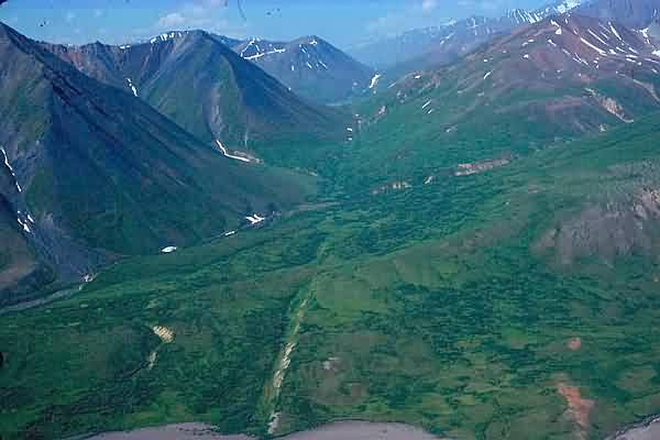
Brooks mountain range, seen from the coastal plain, north Alaska
Faulty plates
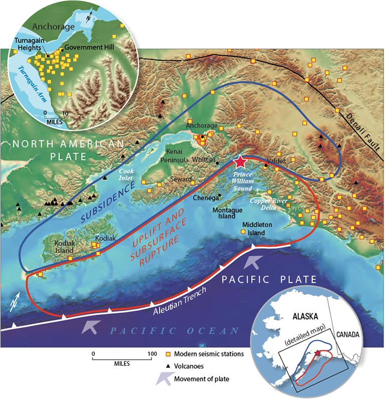
Of the faults the riddle Alaska, best known is the subduction trench. The Pacific plate is moving north at about 5 cm per year. As it sinks, it forms the Aleutian trench which runs from Alaska to Russia.

The image shows how the process works. The Pacific plate comes in from the right (south). As it arrives, a cover of accreted rock is scraped off and left behind, pushed up against the continent. This is fairly weak rock with many fault lines. These are called ‘splay faults’ because the stress of a single fault system is spread over many individual faults. Montague island, off the coast of Alaska, formed this way. Further along, an area of subsidence forms. Finally, the subducted plate meets the much stronger rock of the true continent and slides underneath.

The zone between the two plates, where the continent slides over the subducting oceanic floor, is where the major earthquakes occur. The events are often close to the trench, but along the Alaskan coast they also occur further north: the angle of subduction is not as steep here as it is further west along the Aleutian arc. Note how the trench peters out south of the Cook Inlet, also an indication of the shallower subduction. In Alaska, the subduction is less about sinking ocean floor and more being overridden by the lower-density rock of Alaska. The line of Alaskan volcanoes ends at Cook Inlet, and doesn’t resume until near Canada, with the enigmatic Wrangell volcanic field. This is called the Denali volcanic gap. Everything is connected: the missing trench, the shallow subduction and the missing volcanoes. What is missing is the cause. The suggestion is that the oceanic crust here comes from an oceanic plateau, which formed in the Pacific and drifted north where it met Alaska. The plateau is much thicker than usual oceanic crust, at 20 kilometers. This thickened slab is called the Yakutat crust, and it currently lies underneath the area west and north of Anchorage.

From Martin-Shoert et al 2016, Subduction geometry beneath south central Alaska and its relationship to volcanism. The black line indicates the extent of the subducted Yakutat crust.
The oceanic slab descend at an angle of 30 degrees until it reaches 100 km in depth, after which it goes down much steeper to 400 kilometers. The Alaskan Range, the mountain range that includes Denali, forms an arc where this subducted slab descends steeply; the mountains are pushed up by the buoyant oceanic plateau. Alaska is a well squeezed place.
There is a second fault that is important. The Denali fault follows the arc of the Alaskan Range. Movement along this fault is limited to about 1 cm per year westward. But it builds up a lot of stress. On November 3, 2002, one of the the largest on-land earthquakes known in North America happened here, when 220 kilometers of the fault ruptured in an M7.9 event. The Denali fault has a large bend in it, and Denali itself lies just south of this bend: perhaps the bunching of crust along this bend has pushed Denali to its extreme altitude.
The scarp of the Denali fault
In between the subduction trench and the Denali fault, a part of Alaska has become semi-separated from the North American plate. It forms the Wrangell sub-plate. Anchorage is in fact located on this sub-plate, connected to North America but not fully part of it. It seems fitting.
There are more faults here. In between Denali and the trench is the 200-km long Castle Mountain fault, which runs north of the Cook Inlet: part of it is visible as a scarp on the surface. In 2007, a report came out showing evidence that earthquakes occur on this fault abut every 700 years, with the last one 650 years ago. The authors predicted that an event of M6 to M7 would be possible on this fault in the next century. There are other faults in the area, such as the Border ranges fault which runs east of Anchorage.

The region shows a complex structure, with a major fault through the mountains, shallow faults running parallel to it, and a subducting plate underneath. Each one of the faults and boundaries is subject to earthquakes. Is it a wonder that shaking here is frequent?
A shaken history

M7.0+ earthquakes since 1900. The orange circle is the November 2018 event, and the blue one depicts Jan 2018.
A map of major earthquakes around southern Alaska shows that most of them occur towards the Aleutian arc, and are in between the coastal mountains and the subduction trench. The trend picks up again along the North American continent, were the major events closely cluster around the main fault. In between, things are much more complex. Here, some events occured within the Gulf of Alaska, showing the stress in the oceanic plateau. Two events were near the Denali fault, and four were in-land along the Cook Inlet and the Prince William Sound. Things are far less predictable here.

The map above shows the largest earthquakes in the Cook Inlet area over the past century. Two are on the Denali fault (1912 and 2002); the others are distributed around the area. There is no obvious connection to the known faults in the area: either the earthquakes come from faults that are not visible on the surface, or (more likely for large events) they occur on the frictioned surface between the continental crust and the subducting plate.

Plot the M5.5+ earthquakes, and a bit more of a pattern appears. Some follow the Denali fault. Others are the in middle of the Cook Inlet. There is a cluster on the west side of the Cook Inlet, and a few follow the Castle Mountain fault.
The depths are also clustered. The Denali earthquakes are around 5-20 kilometers deep although two are at 130 kilometers. The ones near Anchorage are around 30-60 kilometers and at the top of the Inlet they are mostly around 100 kilometers deep. There are few strong earthquakes in the upper crust: most earthquakes trace the descending slab. The subducting plate lies about 40 kilometer below Anchorage where it is much shallower than around the top of the Cook Inlet. The earthquakes caused by the subducting plate are thrust quakes.
The land region around Anchorage, including Denali, has around one M6.5+ earthquake per decade. All these quakes would have been major disasters anywhere else in the world. But Anchorage is build to cope. It has experience. It may be shaken – but not stirred.
The great quake of 1964
But one of the earthquakes was too much even for Anchorage. The stress had build up for a long time. The process was the same as the thrust earthquake described above. The subducting Pacific plate had gotten caught by the plate above. Friction kept the two locked underneath Anchorage. In this situation, the subducting plate keeps moving: it has little choice, with the whole mass of the Pacific behind it. So the continental crust, locked in place, was pulled down with it. The effect was that the south side of Anchorage was being pulled down and the northern side pushed up. This had happened over many years, so people were not aware of the slowly changing landscape. Until, on March 27, 1964, at 5:36pm local time, 25-kilometer below the surface, the connection between the two plates gave way. Over the next 4.5 minute, Alaska snapped back into place. The result was the largest earthquake ever measured in the US, and the second largest known worldwide. The magnitude of the event was a staggering 9.2.

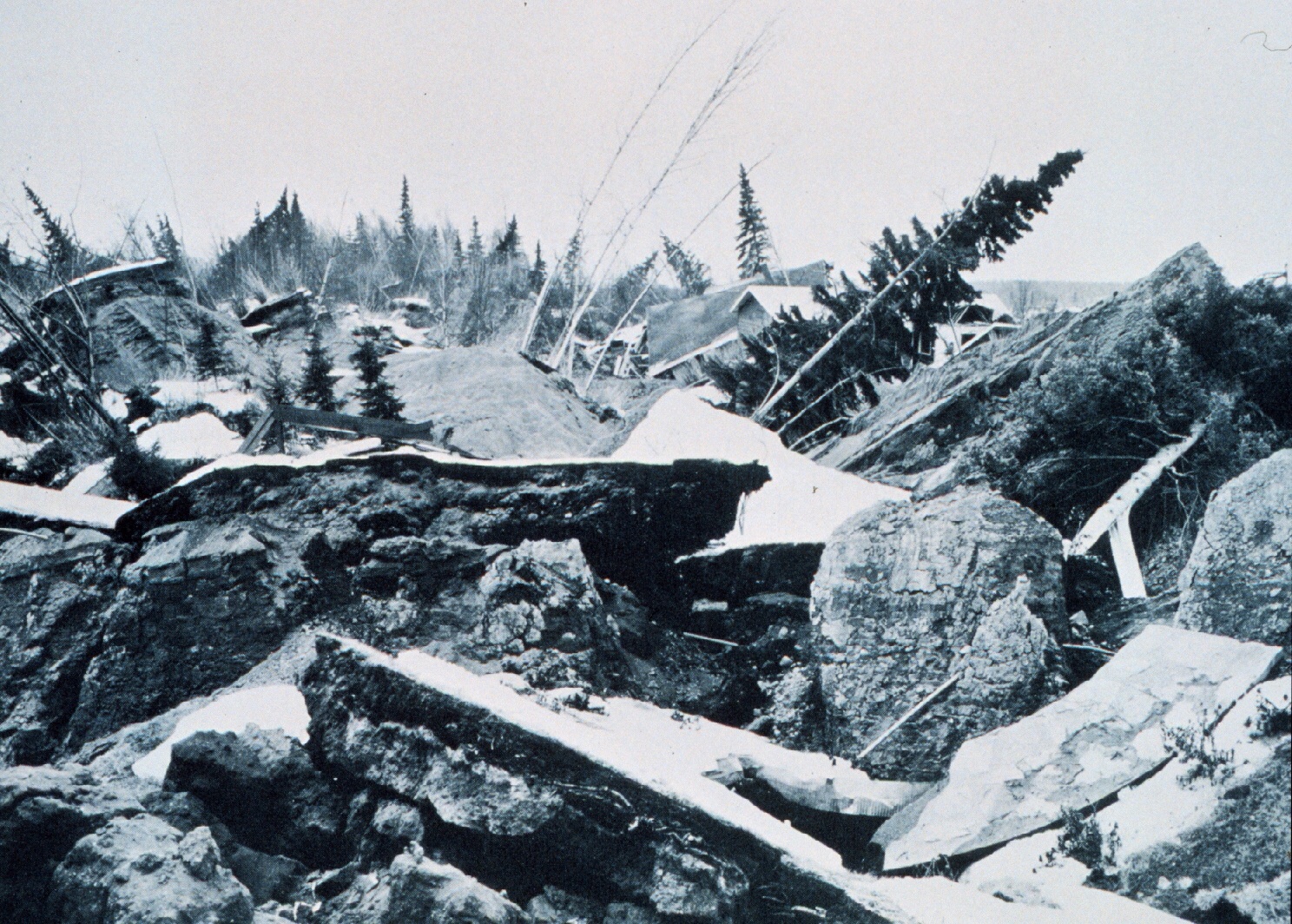
1964. The similarity to the photos from the 2018 earthquake is striking.
Thrust earthquakes of this size are called mega-thrusts. There is no strict definition, but a usable one is to call a thrust quake of M8+ a mega-thrust. What causes a thrust quake to reach this size? That is not fully known. The speed of the subducting plate is obviously a factor. So is the subduction angle: shallower subduction gives rise to stronger thrust quakes. In fact, this mechanism is the only one that can produce earthquakes this size, so all M8+ earthquakes are mega-thrusts. Five earthquakes of M9+ have been recorded in history: Kamchatka 1952, Chile 1960, Alaska 1964, Sumatra 2004 and Japan in 2011. Casualties ranged from an estimated 5,000 for the Chilean earthquake to 250,000 for Sumatra. In this list, the Alaskan quake is exceptional for the very low number of people who lost their lives, 131. Many of the casualties were in the coastal village of Chenega which lost a quarter of its population from the tsunami. At the airport, a controller died when the tower collapsed. But in view of the extreme size, the remarkably low number shows how well prepared Alaska is.
Still, the effects were severe. In four minutes, a century of deformation was undone. The area to the south, which had been pulled down, was uplifted: the highest uplift was close to 15 meter. The subsidence along the sound was less, but still over 2 meters in places. A tsunami formed with a highest run-up height of 65 meters. The wave reached as far as Hawaii. The worst local effects were from the multiple landslides.
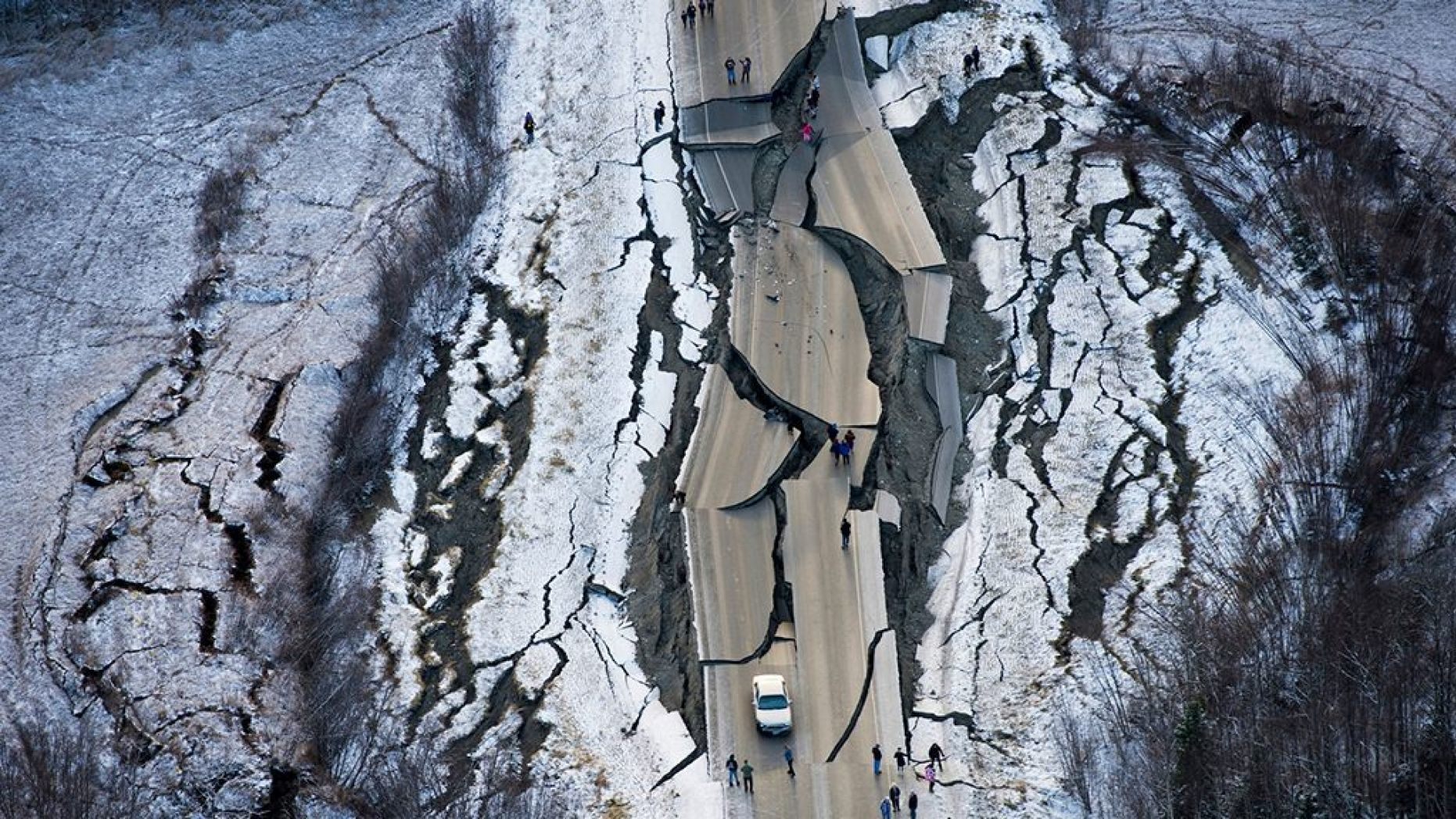
2018
The Anchorage earthquake occurred in the early morning of 30 November 2018. In hindsight, it began on Jan 5, 2018 when an M7.5 hit off the coast of Canada. This is in itself not that unusual. However, it was followed by an M7.9 earthquake off the Alaskan coast, which occurred on 23 Jan. Were the two events related? They seem far apart for that, but such a quick succession of major earthquakes is unusual, even here. One may have triggered the other if it was already primed to go.
And on Nov 30, the earth just north of Anchorage shook when the locking of the continental and subducting plate failed. It was recorded at M7.0, minor compared to 1964 but massive on any other scale. A link between the January and November events seems speculative. However, there were months of minor earthquakes in the general area since the summer of 2018. It seems plausible that the January event transferred some stress, and that the area was already prone to slipping. The minor quakes were a danger sign, warning that a larger quake was coming. Foreshock events here are not uncommon. The M7.9 earthquake in 2002 was preceded by an M6.7 earthquake which occurred 10 days earlier.
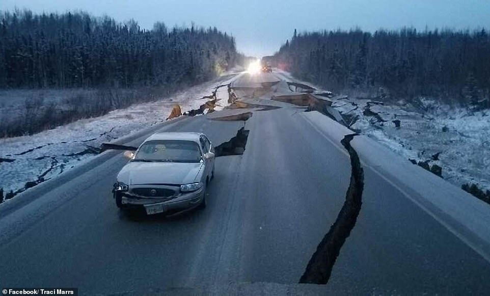
Initial reports suggests that the damage from the 30 November earthquake is remarkably limited. Some damage to some buildings was mentioned, and some roads, specifically Glenn Highway, Vine Road and Minnesota Drive, are badly cracked, possibly affected by liquefaction. The damage is estimated as over 100 million dollar. For such an event, that seems very low. But no matter how well prepared the area is, for people in it is a terrifying experience, made worse by the aftershocks.
The 2018 earthquake happened at almost the same location as the great 1943 earthquake, which coincidentally also was in November but was much stronger at M7.6. The depth of 40 kilometer makes it a thrust quake, with the same process as the 1964 mega-thrust but much smaller. As I write this, the aftershocks are still continuing, at depths of 20-40 kilometers. The aftershocks are all north of the main event, between the Inlet and the Castle Mountain fault. But it hasn’t triggered any movement on the latter fault which is a good thing given the possibility that it may be close to its own event. In any case, typically the largest aftershock is one magnitude less than the main one. The largest aftershock so far is less than that, and so it is possible that there will be another M6 quake in the next few days.

What next?
Normally, a quake this size resolves the stress for quite some time. The repeat time can be hundreds of years or longer. But not here where M7-size quakes seem a dime a dozen. And some earthquakes of this size in Anchorage come in pairs, around 10 years apart. This happened in 1899 and 1909, (a further event in 1912 was near the Denali fault), and in 1934 and 1943. After the 1964 mega-thrust, it was almost 20 years before there was another M6.5 thrust, in 1983. And now, 35 years later, we have had the next thrust. (A few earthquakes of similar size in between were either much deeper or much shallower, and of different type). Before 1964, there had been 11 thrust earthquakes M6.5 or larger over 50 years, or two per decade. After 1964, there were 2 over 50 years. It shows how quiet things became.
So what is next? Have the quiet times after 1964 come to an end? If so, we can expect such thrust quakes to become more frequent. The next one will not be 35 years away but may well be within 1 or 2 decades. But whatever happens, Alaska is remarkably well prepared. It will manage. It knows that the beauty of this land of sea, mountains and volcanoes is build on broken ground. It is part of the package.
Albert, December 2018


The tsunami from the 1964 Alaska quake killed 4 people on the Oregon coast and 11 people in Crescent City, California. At least we now have a tsunami warning system in place which worked well for the Tohoku quake (only one fatality) but is not going to be much use when the Cascadia fault snaps.
Sadly, you are quite correct. The proximity of the Cascadia is going to give MAYBE 10 to 15 minutes travel time, MAX. Rule of thumb, if you get a large quake, don’t wait for a warning, head towards high ground. The warning may not arrive before the wave.
And still hardly anyone there knows about it!
This is the “Tsunami escape route out of Coos Bay North Bend Or.”:
Three Mountain Ranges and a giant slab of Basalt be tween me and there..
… and the bridge is aligned along a near north-south axis, meaning that if the Cascadia fails just off shore (less than 95 km to the toe of the Accretionary wedge.) it will take the brunt of the main shock laterally. (The weakest axis… from the side.)
Supposing that the failure (quake) is a modest Mag 8.0, your looking at MMI-VI+ at the bridge. (Which I understand has had “quake-proofing” applied to its main supports). At that range and size, an reasonable estimate is that it will experience 17+%g lateral acceleration. Now, I’m not an engineer, but I hope the rivets can hold that much mass being near instantly slung sideways at 17.3+cm/s relative to the footings.
If it’s the much dreaded Mag 9.0, and ASSUMING the epicenter is 95 km away (at the toe of the wedge, and not likely to be the actual epicenter) That climbs to 60.3 %g and 52 cm/s. MMI-VIII.
Again, whether it holds depends on the free standing mass and the strength of the materials that it is constructed from… and how it responds to an abrupt lateral acceleration.
To me and my untrained ruminations… I’d be really worried about those rivets holding out.
I could easily do a worse case than this, but that is not my point, that’s just being alarmist. In my opinion, the move from Coos Bay was a very wise decision. My numbers are a low-ball estimate of what the bridge may encounter.
Side Note; The way a supported mass works; Suppose you have 100 tonnes up on some sort of support, at 10%g acceleration, that support would feel the mass move to the side with 10 tonnes of force. Likewise, each and every component of the bridge would feel whatever mass it holds up having a lateral force “pushing” it to one side with that percentage g acceleration. And no, this IS NOT wind loading (though the individual components “feel” the forces in the same manner) This is the mass of the structure itself trying to go a different direction than the support system.
This is why masonry structures fail so readily, While the mortared joints are very good at holding the surrounding bricks in place, they don’t do so well holding the mass of the entire structure above the joint in place.
Note… I also assumed that the bridge was riveted, this may or may not be true. There is a very real possibility that it is bolted together… in which case I hope they used something akin to Grade 8 bolts.
Six ridges on the bolt head – Grade 8. Three ridges on the bolt head – Grade 5. I’ve snapped grade 5 bolts with a wrench (and leg power while leaning up against a wall. I didn’t care, the ready service lockers HAD to come off to facilitate yard work. The crane was going to be available in an hour and I had to have them disconnected from the mounting base.) Failing that my only recourse was to have the bolts cut off.
I was there when they ‘strengthened’ the bridge. supposed to take a 7+ like the Waterboard dam that i used to live under. The effort does not give me confidence… Also there are three other
bridge that are in differnt parts of the city notably 101 south. that are not strengthened. Most of downtown Coos Bay is fill from dredge tailings the old harbor and docks were a good 1/2 mile into the downtown… Most of the buildings are brick and mortar. One added feature is a separate SE/NW fault line that runs under the reservoir and is capable historically of 6+ . I’m going out to the garden an hug my Basalt column…
Yep, bolted.
Albert is a writing demon. This maternal was offered up but didn’t make press time.
this is what I get using the Well-Coppersmith equations. Note that in their paper, they specifically state that “Reverse-Slip relationships are not significant at a 95% probability level”
For a Mag 7.0 in reverse mode faulting:
Surface Rupture Length (km) 35.48
Subsurface rupture length (km) 43.65
Downdip rupture width (km) 18.20 ← With a hypocenter depth of 40+km, this means there is likely no surface manifestation.
Rupture area (km²) 741.31
Max Displacement (meters) 1.55
Average Displacement (Meters) 0.66
And using a USGS non-California propagation model, the MMI vs range works out to
If I remember correctly, I cobbled together a spread sheet version of the formula from one of the “Did you feel it?” related papers. The significance of using the non California model is that energy is not lost as fast with range since most places are not as heavily faulted as California/West Coast US.
Peak acceleration for MMI IX is in excess of 96.6 %g and 80.3 cm/s. At within 16 km of the quake. I don’t think any allowance for depth is in that model.
BTW, there is a nice Finite Fault solution for the event at USGS here. It also agrees fairly well with their moment tensor for it.
Assuming a 10km thick oceanic crust, one (probably erroneous) way of looking at it is that about 0.28809 km³ more material has been pushed into the “sweet spot” for melt formation.
43.65km (subsurface rupture length) x 10km (usual crust thickness) x 0.00066km (average displacement)
Where this idea gets squirrely is that the failure width is only a few km wide (down dip rupture width) and does not extend all the way down to the 110 km contour, the “sweet spot” of dehydration melt.
But hey, everybody else is into calculating magma volume using different metrics, why can’t I? (And mine is a FORE-cast, not a hind-cast. 😀 ) {However it may take a few decades or centuries for my value to show up anywhere)
And with a 10% melt yield, that will make a healthy VEI-2. (28,809,000 m³) … and it just occurred to me, that I have made probably the most useless volcano prediction ever made. Some unknown volcano in Alaska will erupt a strong VEI-2 at some unknown time in the future. And I have the math to sort of back that up. Yay me for spectacularly obtuse ramblings!
Only just noticed this for some reason, but on the description of this picture, HVO said the lava erupting at that time from fissure 8 was very high in magnesium and was full of olivine crystals dredged up from deep in the rift. Fissure 8 was erupting picrite lava with a composition that indicates it was never near the surface, it was not the shallow stuff within the lava lake or pu’u o’o, but rather some much deeper stuff that makes this stage of the eruption probably a lot more like 1840 rather than the 1955 or 1960 eruptions. This, along with the similar eruptions in 1960, and the picrite lava of 1840 and ~1500, probably indicates that any eruption within the LERZ might have to be pretty deep to get that far without surfacing earlier. The lower 1955 vents, and maybe fissure 17, were very likely deep intruded 1924 magma that was heated and pushed out by the newer lava, which only erupted later and a lot further uprift.
This also completely changes my idea from several months ago, it seems more likely that 1840 and 1924 were so damaging to the magma system not because they actually were unusual events (1924 might have been unusual in that it didn’t erupt), but they occurred when mauna loa was waking up or very active. 1960 was just as big of an intrusion as 1840 (new lava erupted there that was from the summit directly so it must have been, though it was slower) and was not much smaller, but that if anything only put a lot more fuel on the fire as kilauea has been hyperactive since then, and even still shows activity indicating rapid recovery right now only months after an eruption 5 times bigger than either 1840 or 1960.
I guess an important point would be when basalt actually becomes picrite as opposed to tholeiite, I’m guessing around 10% MgO, and the fact HVO are saying high MgO probably indicates fissure 8 lava was above that point. It is quite an impressive coincidence that two very large volume effusive eruptions, both of which caused caldera collapse, occurred within a 5 year period. Maybe even 3 depending on what happened at sierra negra, there’s not much info on it though. Out of all these other volcanoes though, kilaueas post-caldera eruptions are by far the most impressive though, almost on the scale of the dead zone eruptions just without the long fissures (some were probably comparable to grimsvotn 2011 in intensity). If Hawaii was historically well observed in the 1700s (properly anyway) or if the Polynesians had a well developed writing system and recorded things the way we do today, then no-one would think kilaueas eruptions are small next to mauna loas, probably the other way around even.
And just because I think I’m now quite notorious for my long comments, something else to ponder. In the last centuries before 900 AD, kilauea had its most violent and explosive summit eruptions in its geological record, and this was around 500 years after the initial formation of the powers caldera. Today’s caldera formed around 1500, which was about 500 years ago… Maybe another period of long lived effusive summit activity is not on the horizon, but rather a period of increasingly violent and fast summit activity instead, with continued effusive eruptions from the east rift and expansion of the caldera to the south with eruptions moving into the koae faults too, if the south caldera chamber collapses. That part of kilauea is probably going to change radically over the next millennium.
© anotherlongcommentabouthawaiibyturtlebirdman 😉
Long… maybe, but substantial.
A welcome comment that elicits thought.
Holuhraun had similar temperatures and compositon
and just like fissure 8 full of small olivine crystals
Holuhraun just like Puna 2018 dragged up materials from deeper inside the volcao – tectonic system
Might be too soon for Koae to join the party but I agree with the part of the southern reservoir collapsing and explosive events in the horizon. The date of formation of the Powers Caldera is not well constrained and as far as I know probably was earlier, 100 BC- 500 AD, but also to consider that the caldera might have filled to almost overflowing or maybe even small overflows before the Kulanaokuaiki explosive events started together with presumably big collapses around 600 AD. But Mauna Loa makes a big difference, around 500 AD Mauna Loa was very active, the Panaewa flow and extensive summit overflows which btw likely made Mauna Loa a little taller took place around then. This together with Kilauea not doing almost anything from 100 BC to ~600 AD, as far as I know makes me think that Kilauea had long periods of dormancy back then.
Yup Kilauea likley does superhot basaltic plinian eruptions when the summit caldera wakes up after some period of sleep. Think Kilauea Iki but much much larger and more violent.
Large scale Kilauea summit eruptions are like Sierra Negra and ice free Grimsvötn and Etna plinians
1959 was also very primtive and very hot and deep source and picrite composition.
The extreme temperatures of 1959 suggested at acended quickly from Kilaueas very hot deeper levels.
Unlike 2018 .. 1959 at 1300 C woud be a crystal free glass melt as olivine melts at little more than 1200 C.
Some cooler first phase lavas of 1959 had a compostion similat to fissure 8 at early phase with numerous small olivine crystals in the glass melt. As 1959 went on the lavas became hotter and hotter and some videos the fountains are totaly white hot. The hotter and deeper the lavas come from the more primitive they will be.
Kilaueas deeper roots are so hot that the basalt magmas are a 1510 C liquid, the journey upwards takes 8 years according to HVO data and during that time it goes upward it cools from 1510 C to around 1250 C as it collects in the summit magma resorvair just south of under halemaumau.
I’m surprised it takes 8 years for the magma to move into the volcanoes, last year there were a lot of very deep earthquakes in the area under Pahala, those are still happening now, and that is also considered the largest source for kilaueas magma at the moment, right over the hotspot. 6 months afterwards, this years eruption started. Similar but smaller swarms occurred in 2015 when the lake first overflowed, and Ithink in 2010. I think it probably takes much less than 8 years, likely less than 1 year, as this years event was definitely preceded by a large pulse of magma. Pu’u o’o slowing was not the cause of the lava lake overflowing at 7 times the rate of normal flow from 61g. In affect this eruption this year would have likely happened anyway with or without pu’u o’o or the overlook vent, although the summit collapse might not have been as deep without the shallow upper system draining out.
It also probably shouldn’t be surprising that kilauea can have large eruptions, it is single handedly responsible for 1/100 of the magma supply on this earth, out of at least 1500 active terrestrial volcanoes. I’m not sure which volcano is second, probably klyuchevskoy, but it is still distant, in the past 6000 years, klyuchevskoi has erupted maybe 100 km3, kilauea kas probably erupted at least 1000 km3 and maybe a lot more if the puna ridge is included (most of its surface is 7000-2000 years old).
Yup all other volcanoes are tiny compared to the immense volumes of the Hawaiian Giants
Im not impressed by any other volcano= Hawaii is my favorite.
Turtlebirdman
I think if the magmas took 1 year to rise from the hotspot partial melting zone…
They woud emerge at 1500 C and flow like liquid slag
Kilauea is 1500 C as hot as liquid iron at her roots
I favours a slower ascent where the magma cools a little before erupting
Still the ascent coud take less than 8 years I agree with you
In reading what I said before, 2010 was indeed 8 years ago… In that case then there could be some action in 5 years, and then maybe even more 2 years later… 😉
Personally I think it wont take that long though, something by this time next year almost for certain.
I think that Pahala is always having quakes, in terms of depth it fits very good with an inferred source (from a slow seismic wave anomaly) for Kilauea at around 30-40 km deep that also extends to the south (Loihi?) and there is another at the same depth under Mauna Loa which might be linked or at least interact to a certain degree with the one under Kilauea? to explain why when the supply into one volcano rises the other one decreases.
Kilauea is right now not recovering particularly fast, if a surge comes in it could speed up considerably things up and we would probably notice. I am more concerned right now with Mauna Loa that continues to throw northwest flank and summit earthquakes discretely.
For unclear reason these comments were held back for approval. Herby released from the dungeons – admin
This is probably similar to the 1975-1984 eruption, with buildup, followed by a small eruption, then more buildup and a larger eruption some point within the decade afterwards. It might just go straight to a big eruption though and take everyone by surprise, but I dont think it will be returning to dominance anytime soon though, the 1840-1950 period seems to have been the first in at least 300 years before that point.
That period before panaewa around 500 AD seems to have been the first time like that in some millennia though, it would be quite unusual for mauna loa to go back into a phase of activity like that, even though its caldera is now filled to overflowing. Maybe its next eruption will cause a caldera collapse, as the supply rate is nowhere near as high as it was before 1950 and that will probably lead to rapid magma draining and fast collapse unlike on kilauea this year where it was slower.
With concerned I was just referring that the way things are going maybe next Mauna Loa’s eruption comes before Kilauea’s, it is not very safe to say that yet though. Another period like ~500 AD doesn’t seem likely, Mauna Loa is probably not able to maintain continuous summit activity either with its current supply. The last long lived summit eruption, 1872-1877, happened well into a period of dominant activity of Mauna Loa, and I don’t think we will get one of those this century (but who knows…). An eruption of Mauna Loa is probably coming in the next few years, it might even happen at some point in 2019, or if not then within 5 years I think there is really a high likelihood. This eruption will probably be the only Mauna Loa eruption we will see in a long time, it might be a couple of decades before the next one takes place. I am really curious to see if this developes into a northwest flank radial eruption or not. I think there is an ongoing intrusion in the northwest flank, but even if there is one of the rifts could give way first or maybe just end up in a small summit event which wouldn’t reduce the pressure of the summit reservoir that much so a rift eruption should be expected some years later.
it is something to wonder whether a large mauna loa eruption would reduce pressure enough on kilauea that a magma surge happens from depth. This could have happened in 1950, in 1975 it also could have happened although in that case it caused a large intrusion and earthquake instead of a big new eruption. Pu’u o’o is probably the delayed 1975 eruption.
Kilauea is not recovering fast by its standards, but it is recovering impressively fast for a volcano that has just done its equivalent of a VEI 6. Leilani was about anywhere from 50% to as much as 90 % of the volume of holuhraun (probably around 70%) but after holuhraun bardarbunga was deflating for over a year afterwards and has shown no signs of getting prepared to erupt again on any significant scale. Kilauea on the other hand has already shown recovery in all the places it has erupted from recently, and in general is showing signs of erupting in the near(ish) future, though not immediately. JOKA station seems to have flatlined, so this area is probably filled up, and over the next months-years the rest of the volcano will probably fill up too and I guess the next eruption will happen in the lowest point or the area where magma is closest to the surface (probably pu’u o’o area still, or maybe upper east rift) but the next large eruption (1977 upwards, with lava flows/tephra beyond hazard zone 1) will be in the caldera or lower on the rift.
Turtlebirdman here is my opinion about ascent rates in Kilauea
Yes its fast but slow enough so it dont erupt at mantle temps
My own opinon about Kilauea magma ascent rates, its fast but not as fast as you say
Kilauea is earths most powerful basaltic volcano in terms of magma supply.
But I think it takes longer than less than a year for magma to be made in the Plume partial melting zone and rise into an eruption some months later. Had it been like that = Kilauea woud be erupting 1517 C magmas thats flows like liquid slag. The magmas woud not have time to cool to the 1195 C and 1220 C temps thats typical of the summit. Kilaueas IKI s white hot magmas suggest thats acsent rates can be very fast as you say. Kilauea IKI s hottest phases suggest it can rise very quickly.
Ascent rates also depends on magma supply.
Kilauea is hell hot in her depths… so hot that iron coud melt inside there.
My opinion on magma ascent rates in Hawaii is very quick but slow enough for it to cool down a bit
Magma ascent in Kilauea is very fast as you say, but not so fast that it emerges at ultramafic temps.
As Kilauea enters her main shield boost magma supply will speed up.
And in the far geological future if the Hawaiian hotspot keeps boosting= it may do Komatite as the galapagos did 90 million years ago when that plume superplumed.
Hawaiian hotspot is extremely powerful and hot these geological days. ( 1520 C maybe at astnosphere )
Had the Hawaii hotspot been on a thinner litosphere where galapagos did, there woud be an even shorter path for the magma towards the surface, then the hotspot wpud produce superheated basalts or maybe even ultramafic lavas.
In other words simple version
Had the Puna Leilani magma risen from the hotspot in less than a year
It woud erupt at over over 1500 C
and be a very very very scary eruption of lava that flows like liquid iron
and now i know even more than i did on Friday morning at 8:30. .. can’t prove it, but it seems like one week after any larger earthquake up here, a “larger” aftershock occures. So we’ll see! i’m just prejudiced but this is my favorite post by Albert so far! 😉 Thanks, Albert! Lots of information and i’ll be returning often. Best!motsfo
My own opinon about Kilauea magma ascent rates, its fast but not as fast as you say
Kilauea is earths most powerful basaltic volcano in terms of magma supply.
But I think it takes longer than less than a year for magma to be made in the Plume partial melting zone and rise into an eruption some months later. Had it been like that = Kilauea woud be erupting 1517 C magmas thats flows like liquid slag. The magmas woud not have time to cool to the 1195 C and 1220 C temps thats typical of the summit. Kilaueas IKI s white hot magmas suggest thats acsent rates can be very fast as you say. Kilauea IKI s hottest phases suggest it can rise very quickly.
Ascent rates also depends on magma supply.
Kilauea is hell hot in her depths… so hot that iron coud melt inside there.
My opinion on magma ascent rates in Hawaii is very quick but slow enough for it to cool down a bit
Magma ascent in Kilauea is very fast as you say, but not so fast that it emerges at ultramafic temps.
As Kilauea enters her main shield boost magma supply will speed up.
And in the far geological future if the Hawaiian hotspot keeps boosting= it may do Komatite as the galapagos did 90 million years ago when that plume superplumed.
Hawaiian hotspot is extremely powerful and hot these geological days. ( 1520 C maybe at astnosphere )
Had the Hawaii hotspot been on a thinner litosphere where galapagos did, there woud be an even shorter path for the magma towards the surface, then the hotspot wpud produce superheated basalts or maybe even ultramafic lavas.
Magma ascent to Kilauea is fast upwards, but slow enough to allow it to cool a bit
Had the Puna Leilani magma risen from the hotspot in less than a year
It woud erupt at over over 1500 C
and be a very very very scary eruption of lava that flows like liquid iron
And after Alberts Tour de Quake I will chime in with something far smaller.
We are seeing “popcorn” at Hekla in stunning detail.
These micro-seisms are to small to be picked out by the automatic system. They are brittle quakes indicating snapping rock as magma pressure causes fractures to form. They are common prior to eruptions.
I should point out that seeing them at Hekla is a first, and it would have been impossible to see them prior to the recent massive expansion of the Hekla-network.
Now Hekla can truly sing for us in glorious high-definition.
Very nice Carl…. I freaking wants a Hekla eruption
the Icelandic Balrogs inside Hekla are getting restless and fiesty
That is nice. Can we tell where it is located?
Thanks to the hardworking technicians of IMO we can indeed do that. It’s on the NNE part of the mountain at 2-4 km depth.
The new stations are marvelous in resolution 🙂
Are you sure about the depth? This time of year is frost quake season. They tend to look like this on the drums.
I have them on 6 seismos, so easy to depth assess.
Is there a list or map somewhere with coordinates of the seismic stations? In particular the new ones. Also, do you have access to raw waveforms or in other ways more detailed information than that in the drumplots? I get a feeling sometimes that you must have more detailed information than the publicly available.
Replied privately to you via messenger.
Thanks!
And Carl will get a miniature pinscher bark machine in Christmas present.
: ) Nu jävlas jag = Teasing carl : )
Now you can suffer from upptyppingar on the Upptyppingar Bridge near Upptyppingar volcano. The name is multiplying on the maps.
the red coat helps people to understand that this is in color and not black and white. 😉
Carl what do upptyppingar means in english and swedish?
I knows its something dirty… but really is it that dirty?
If its just breasts its pretty neutral
Is it even more dirty than that? what does it means
Google translate doesn’t translate it to anything, but it probably isn’t far off from mt viagra by the way it sounds though…
Oh, it is far worse than Mount Viagra. On a scale it is over on the next continent from Mount Viagra.
Google translate does a right down hash of translating it. Up Penis is the translation on Google translate. The correct translation is far far worse.
On Google Translate it does translate it if you put it in as “upp typp ing ar”!
I googled it yesterday, from the result you could say an American colloquialism for upptyppingar would be “wood”
Out of interest, what is the actual origin this unusual name?
Is there a particularly suggestive rock formation/landmark in the area or is it more related to Local/Norse legends?
Dunno, based on the way Thor dealt with the flooding Gjálp was causing, I’d guess the latter.
I will not write it out in here since there are children reading this.
Iceland has another volcano named Geirvörtur, there are two vents, east and west geirvörtur. Geirvörtur means Nipples in Icelandic.
Jesper, remember that I am also a Swede, I am not shy of writing and saying naughty words, so just imagine how bad this one is before I censor myself.
And if you translate it, don’t publish it here.
Such an upstanding contributor you are Carl 😛
Very much so. Someone should erect a statue in his honour…
Being English, I’m merely treating this with a stiff upper lip.
Alaska is indeed magicaly beautyful.. active subduction orogeny belt
The snowy peaks and glaciers and cold pine rainforests and huge rivers and fjords and angry volcanoes.¨
Whales, bears, whaleruses, seals wolves and moose.
Alaska is one of the most beautyful states in the US
Im living in similar latitude as Anchorage and Katmai
I haves a milder climate beacuse of the Gulf Stream
Still Alaskas coasts are pretty mild and humid, but not as mild as Oslo and Stockholm is on similar latitudes
And Alaskas Kluane national park never left the ice age
It still looks like 20 000 years ago and is likley cold because that mountain orogeny front is elevated
Near Yakutat bay there is a huge glacier at ( latitude 59 ) that spills out over the coastal plains like a huge sillica rich lava flow. That glacier tounge is 40 kilometers across and 100 s meters deep
It have formed a huge meltwater pond at the coast near the sea thats blue in Google earth beacuse of silt and sediments
From one of my correspondents near the epicentre …
Originally posted by Nik
https://www.volcanocafe.org/the-anch…quake-of-2018/
A very good ‘look under the lid’.
==
Thanks I read the whole thing……..it is interesting and educational.
We are still getting near constant quakes……just had a 4.8
Last night I slept fully dressed, including long johns, plus in a heavy down parka, with boots on, holding a 36″ crowbar.
I did not get much sleep, but apparently few in south central slept well last night.
Interesting choice of tools to keep near your sleeping spot. That says quite a lot.
During hurricane season I keep a functional and recently tested chainsaw in the house.
“This Is Chance: Anchorwoman of the Great Alaska Earthquake” From the 1964 quake https://99percentinvisible.org/episode/chance-anchorwoman-great-alaska-earthquake/
This was not an earthquake of Anchorage. It was epicentered across the Inlet and damaged roads and bridges in the Mat-Su Valley. Please don’t pretend that you don’t know where Sarah Palin lives!
/Released from the holding bin.
Admin
We are well aware of exactly where the earthquake had it’s initial break. Do note that Albert stated on which fault the earthquake happened.
Now I have a question in turn. Who is Sarah Palin? Is she related to Michael Palin? And please feel free to tell me where she lives (if indeed related to Sir Michael).
The location is shown in the post. The epicentre was 10 kilometers from Anchorage whilst Mat-Su valley is twice as far from the epicentre. This is close enough for significant damage there as well but obviously that has been far less in the news than Anchorage. And I do know who Sarah Palin was but have not heard anything about her for years and have no idea where she lives.
offering an olive branch: There is no bridge from Anchorage across Knik Arm and the people who live on the other side have to make a long and sometimes dangerous drive. Why don’t they live on the Anc. side? There is little room left and rentals are sky high and people are generally smuched together with tiny yards and the crime rate is awful (generally across Alaska now…. didn’t use to be that way… very sad) There are few jobs in the Mat Sue valley altho it’s getting better with the increase of medical facilities etc. So in short, people who have to travel this long distance loose the idea that they are, at some point, sometimes travelling back toward Anchorage. There is also the idea that if You live in Anchorage, you are not really an Alaskan and as dependent on Your neighbor as the outliers are. ((oo proposition there)) so there is some negative observations of the ‘other’ at work too. The Mat Sue/ Wasilla/ Palmer group is very wide spread and many people actually live closer to the epicenter than Anchorage while still hailing from the Mat Sue. This person might be one of them. Anyway all these factors might add to misunderstanding. Best!from motsfo who went out last night and bought more bottled water even tho on a well.
Thanks for the clarification which is very helpful. There are always local issues that are not known further away. Being from a rural area myself I can sympathise with the issues (but was puzzled by the reference to Palin). Is there a ferry service across the Arm?
And thanks for the nice comments about the post. I hope it was helpful.
no ferry service that i’m aware of but it was tried with hovercraft i believe for a while but strong winds and horrific tides cut into the ease of running a hover. and i could be totally wrong about the hovercraft. The far side has no easy access, mud flats and clifts. This is no easy place to live… why do we live here? Pride maybe, Stupidity, Stubborness, Laziness, Poverty, Ignorance of the greener, easier grass on the other side… and if people balk at my attitude, You can state what You think; this is what i think being here for many years. There is also an intoxication which overtakes one here spoiling one for life anywhere else. Here there is the glory of overcoming, of surviving, of reaching the mountain top and still being alive. Other places pale after living here long. Man, was i think, made for challenges. And up here we got ’em. Best!motsfo
Humanity is fascinating in all its diversity. You wouldn’t want it any other way. A lot of these issues play in Hawaii’s Puna as well. It was sad to hear about the crime problem.
Well Mots, since I am also a crazy northerner I totally understand you.
There is a glaring beauty in the great north that you never get anywhere else. And to be able to thrive in conditions that are deadly if you make a single mistake has it’s own beauty in life, and breeds a certain degree of bonkers in the bones of a person.
So, I really understand you.
My personal favourite was to take long walks in the middle of large blizzards. The energy and feeling of being well and truly alive is transforming. Not to mention the hot chocolate with dab of whiskey in it as one comes home frozen and happy.
But, you are one upping me with the earthquakes and volcanoes, I had to go and get married to get those. And warmer weather 🙂
After googling I found out who that is. Seems to be some local politician in some town called Wasilla.
no room left above, must reply here….. Yeah, we do understand each other, isn’t that marvelous and mysterious at the same time…. i, unfortunately, married someone here so have no excuse to go elsewhere. Nice picture of hot spiked chocolate and steam rising off Carl as he takes off his hat inside after blizzard treck. 🙂
Bah, you guys get the beauty of surroundings, all I get is the entertainment of watching the stupid.
…and mosquitoes that mimic the slow graceful flight of B-52s as they glide across the pool room floor. Till you whack them with a pool stick.
The larger earthquakes at Hekla has started again after a day of brittle quakes and tornillos on the seismographs.
The network is more sensitive now than it was in 2000 s
Hekla is not a frequent erupter, we may still wait many years maybe 100 s of years for an eruption to arrive.
I can with a high degree of certainty state that this will not be the case Jesper.
Do you think it will go off before the new year?
It’s not impossible. As it is looking now it could go off in a few hours. But, it could also go off in months or years away.
I hope it waits 85 days to erupt on my birthday again :>
Ok, Jumping in with no knowledge or anything useful to add, but my birthday is on December 22. Just throwing that out there for the office pool. 🙂
Mine is January 7. And the baby is due for 27th of January. If that’s the case, I’ll give as second name Hekla
Depends on Supply rates and other stuff
The 2000 s eruption was quite small 0,2km3 and likley Hekla have charged up twice as much as lava 0,4km3 20 years after that. The next eruption coud become larger than 2000
Öræfajökull keeps being busy with quakes.
Öræfajökull is a classic closed conduit system in upper parts.
The upper plumbing is freezed and brittle like many infrequent erupters are.
Only an extremely strong earthquake swarm will convince me its going to erupt.
The magma will cut its way through the volcano.
There will be green star mayhem galore when it well decides to wake up.
Green Stars everywhere! The green stars will dance on the floor
Greenstarcalypse when it wakes up.
The Balrogs inside Öræfajökull is getting fiesty slowly
Carl.. how long have Öræfajökull been doing these daily earthquakes?
Its not on the spreading axis so this is magmatic signs I think
Jesper, I would say it would take Oraefajokull a few years to erupt, with several deep swarms in a similar fashion to how was with Eyjafjallajokull. And a very strong swarm before the eruption.
Anything between 2 and 20 years from now.
It looks increasingly likely, that the sequence of next eruptions in Iceland will be Hekla, either within the next few weeks or in the first months of 2019. Then Grimsvotn around mid 2019 or in 2020. And Oraefajokull either in the late 2020s or in the 2030s. There will be other eruptions in the 2020s, which ones its difficult to say, but the other likely candidate is Askja.
Askja is an intresting volcano.
Its a true mar rift volcano without any transform faults.
Askja is closer to the hotspot than Krafla is and more active.
Maybe Askja will do a 1961 again with anything basaltic from 0,1 to 0,5km3 next time it erupts.There is possibility for larger more evolved eruptions too.
Askja either feeds from the mantle during a rifiting episode that makes basaltic magmas
Or it erupts from the magma chamber in the central volcano in the crust
That makes more evolved magmas and larger ( plinian explosive eruptions ) it can also do lava domes. Askja is a bimodal caldera volcano.
Here you haves a fun video of the 1961 eruption showing beautyful Hawaiian style fluid basaltic activty: https://www.youtube.com/watch?v=udoCcutHN28
Yes, Hekla is a little noisy tonight.
/Direct link removed. From now on use the mirrored ones on our Heklapage. Admin
Another moderator chimes in; The reason is that linking to our mirror lessens the network traffic on IMO. This gives them less congestion and reduces any detrimental effect should stuff go tangential with their volcanoes.
If something goes terribly wrong we are better suited to handle a massive influx of traffic and should it take us down, IMO and emergency services there are not adversely affected. Not that our network is necessarily any better, but if volcano-cafe takes a face-plant, it doesn’t affect people living there.
It looks increasingly likely that Hekla may erupt before Christmas.
I still stand for my prediction that Hekla would erupt in the first week of December (within two weeks of that swarm we saw some days ago).
Maybe by Friday the 7th Dec 2018, so we all have a change to book a weekend flight to Iceland.
Anyone want to make guesses?
Dang, made a guess above before I saw your post. Dec. 22.
HVO has spoken, and listed the possibilities for what’s next at Kilauea:
“New summit lava lake, resumption of eruption at Pu‘u ‘Ō‘ō, lava flows in Puna, further summit collapses, explosive eruptions from the summit, eventual collapse of the entire summit, renewal of caldera filling with lava eventually overtopping the caldera rim, decreased magma supply so that the quiet lingers for years, increased magma supply so that the quiet ends in months, resumption of Mauna Loa activity…or something else?”
Pick your choice!
Most likley is violent wakeup of the summit supertall lavafountains
And later a new lava lake and a long period of caldera lava lake overflow fillings.
New lava lake after violent wakeup. Lava lake activity resumes
Eruptions in the ERZ likley too with a new Mauna Ulu like event or 1960 s again and maybe a new shield building phase.
With a magma supply of 0,3km3 every year it will only take 3 to 4 years for Kilauea to refill what was lost during the puna 2018 summit drainge
All of them at some point in the next 50 years, except the slowing supply. Explosive eruptions and overflows might be mutually exclusive though.
Yes, eventually all of them will come to pass, except resumption of Pu’u’o’o depending of what you consider Pu’u’o’o. As an location in the rift lava will eventually come out of there but as a separate eruption, but if the pit lights up in orange even several decades afterwards there will be someone surely talking about the rebirth of Pu’u’o’o.
As the most inmediate option out of those mentioned I will go for lava flows in Puna, for Kilauea because as I commented just a moment ago maybe Mauna Loa wakes up before Kilauea does. It would be funny if the SWRZ erupts next, it would make everyone wrong.
Everyone would be wrong, but the SWRZ is probably primed for an eruption, the 1974 intrusion put a lot of magma into the rift which didn’t erupt, and in 2006 there was aseismic inflation, and in 2015 there was almost an intrusion to the rift, and the seismic SWRZ is connected to the ERZ pretty intimately so things are possible. In saying this though, I still think that while the east rift conduit is open as far as it is, that the next eruption of any significant volume will be down the rift beyond pu’u o’o, or at the summit, in both cases for certain within the next 10 years. I think the upper ERZ, volcanic SWRZ, and outside of the caldera apart from the 1982/1974 vent area, are very unlikely right now.
Thanks, Albert, again for this informative article….. my Daughter (the one who keeps me on the internet) has shared it with her questioning friends and now they know more than they did on Friday morning too…… Thanks for All You Do, Best!motsfo
The new He stations near Hekla are recording signals the most clear now.
Carl, and others ofcourse 🙂, is there a map and or are coordinates of the precise position of the new stations available?
That information is not publicly available.
To bad. Thanks. 🙂
Carl,
Are they private, or is it just that Iceland is different on releasing information?
Thanks
Mac
IMO has always been very open with its data. But with the internet, and the fact that someone has developed a tool that continuously accesses the seismographic data, the data rates become prohibitive. The servers can’t cope with the flood of requests and therefore they have the choice between blocking access or hiding the data. This is why we run the summary Hekla page, not to add to the IMO data rates.
Thanks
Mac
Any chance of sending a UK / Swedish / EU diplomatic mission to Mila in Iceland to ask them to get that Hekla webcam fixed? I don’t suppose so. The old “Dalek Cam” from Burfell seems stuck on a couple of photos taken years ago. 🙁
Carl since you got to see Holuhraun Im sooo jealous!
Did you measure the temperature of the lava? did you take home any Holuhraun basalt rocks?
Holuhraun is one of my favorite eruptions in my lifetime so far
Large Fluid Basaltic eruptions are always my favorites, the more lava there is at once and the more runny it is the more tasty for the mind.
I also saw the eruption, but I don’t mean to make you jealous 🙂
It was very difficult (not to mention usually illegal) to drive or land close to the eruption
I just observed the eruption from a private small airplane some 500 meters above the crater. Not directly above of course!
Some rich people managed to hire an heli and land there, but they paid a huge bill to to the police.
There was also a day (some days before I took the flight to Holuhraun) when I had my jeep ready to break the law and drive to the eruption spot. Rest assured I didn’t!
As I almost immediately cooled my temptation by realizing the many ways I could have died: opening cracks, daily M5 quakes, sinking sand and snowstorms, but mainly a high risk of a jokulhlaup, and certainly an extreme danger from gas toxicity.
So I stopped short of 20km away, seeing the red glare on the horizon, and nauseating gas already in the air. That was already dangerous (even if the Sprengisandur road was open) because in those early days we were all oblivious of how much SO2 was being released.
I actually met one jeep with foolish (yet lucky) Polish tourists that have driven there and back. I was very jealous of them but I told them how near death they were! They were unaware of it.
To top the adventure, that day when I drove back I actually lost my jeep brakes and I was completely alone in the mid of Iceland near a big erupting volcano. Scary, but s–t happens quite regularly when driving in the middle of Iceland.
Ayways flying above Holuhraun was awesome and very hot.
Found two more on Hekla. “HE1, and HE2”
Oh and hey everyone. I’m still here.
/They are mirrored on our Heklapage. We will from now on remove all direct links to lessen the stress on the IMO servers.
The final remark needs a bit of clarification, does that mean that you are someone that we have banned and that has snuck back?
Admin
Definitely something going on. If the weather is as nice as it is where I live, there isnt enough wind to make that noise.
The weather seems ok in southern Iceland (though chilly). The seismographs seem exceptionally sensitive. It is worth keeping in mind how small these earthquakes are.
Smallest today was M -1.6… It is so small that it is akin to dropping a 1kg stone from the roof of a one story building.
And the Admins after some head wrinkling has remembered who you are.
Mount Viagra! *chuckles*
Carl! You knows that I wants to Invade the world with pengiuns
Did you know that Iceland is the ideal place for the more northen living penguins, just north of the south pole. continent. King Pengiuns coud be introduced to Iceland, they will love the cool climate and rich seas.
I wants to introduce a few thousands and we gets a breeding colony in Iceland, thats woud put the pengiuns strong on the northern hemisphere for the very first time.
Pengiuns are also biological and ecological aliens in Iceland and northen hemisphere
Mwahahaha
“Viagra hills” I do believe was the reference. I just had a word with Jón Frímann and he is pointing this to ice quakes. We are having a still weather cold snap right now. And that results in icequakes.
With all due respect to Jón, but he is wrong. The waveform from an ice quake is looking very different. People have a tendency to hang up on ice quakes, but they are incredibly rare in Iceland due to the lack of large scale seasonal permafrost. No permafrost, no ice quakes.
It can’t be icequakes because Hekla has no ice. But it could be frost quakes: that would need checking against local temperature data to see whether they only occur during hard frost.
Last time I saw them on a wide scale was last winter (or spring) after a period of thaw followed by a rapid temperature drop. The SIL network threw out false detections all over the highlands, in particular around Askja. These detections were removed upon manual review. The appearance on the drumplots was very similar to the current popcorn activity.
Now, 48h before the current activity started, the temperature at the Búrfell station started to drop below freezing, possibly creating conditions for frost quakes. -10C is still a bit on the warm side, but I don’t think it’s wrong to consider frost quakes as a possibility. However, as I said below, they should be shallow.
DIfference is that Askja has Tjäle, Hekla does not.
Vatnajökull likley do not have that either
with its high geothermal gradient
Without the glaciers vatnajökull woud be full of geothermal lakes and pools and bubbling mudpots and many hot sulfur vents and hot fumaroles. Grimsvötn woud be like Ijen without the Ice maybe?
Sulfur everywhere and acid water in the caldera lakes
with higher sensitivity, we may be seeing things that weren’t well known before!
I totally agree, what we are seeing now would not have been possible to see prior to the 2000 eruption. And some of it not even a few weeks ago.
Including frost quakes which let in water.. Hekla as a dame blanche.. it was notable that the popcorn pops during the coldest time of the night.
Why do the Hekla micro-quakes look double at the moment?
Two out of three episodes was during the day.
But, if people will think this is frost quakes I am not even bothering to argue since the signals are not showing any frost quakes. Calling a car a horse does not make it shit.
No, they do that of their own accord…
The exctinct geirfuglasker birds in Iceland, was in many ways… the northen versions of Pengiuns
Convegent Evolution in two very diffrent bird groups lead to similar solutions for life and the two groups lived a very similar life. A Garfågel is very very similar to a pengiun in lifestyle and behaviour
thats where the Northen Hemispheres anser to penguins
“Garfågel is very very similar to a pengiun”
Except the last extant penguin was not strangled…
Again, an extinction that were the combined effects of at least two separate but equally devastating events.
Volcanic activity and the overzealous desire of museum curators.
And evidently, Penguins have their own variety of stupid. Homo Stultus is not unique in it’s skill set.
https://www.youtube.com/watch?v=_v7CPzuGwRA
And in defense of the Penguins… Young Homo Stultus engage in “play” that actually hones the skills for interacting more effectively and efficiently in the adult stage, this Caring for a Snowball behavior probably serves a similar purpose unique to Penguins.
I need new glasses.
I just read ‘Homo Stultus’ as ‘Homo Stuffus’ and thought “Is that the geneological term for taxidermists?”
Before you go introducing an exotic species to Iceland you might want to do an EIA. Somewhere in the sea around Iceland are native species who occupie the niche the penguins would step into. ‘A Gafagel is very very similar’ is still not the same. The knock on effects could be a disaster. Currently I’m stressing about Asian hornets that somehow got into Italy and are now arriving in the U.K. With all due respect to your local knowledage which I accept will be more detailed than mine.
There is an increased seismic activity of Vesuvius. About 20 earthquakes per last two days and slightly deeper then usually.
http://portale2.ov.ingv.it/webdata/segnali_rt.asp?loc=Vesuvio&IdMap=1&sta=BKE&comp=V&A=0&B=0&C=0&t=GMT&id=6
Seems like Þórðarhyrna wants to join in. Small swarm this morning with a couple of M2 quakes. There is no doubt that pressure is increasing in the Grímsvötn system.
I thought frost quakes happened when the ground is saturated with water from thaw or rain and the temperature drops suddenly from above freezing to really cold. Water freezes to ice and widens cracks in the ground. “Frostsprängning” in swedish.
Temperature swings happen a lot in Iceland. At Hekla, with its unseismic history, I think it is much more likely to see frost quakes than “popcorn”. In the pixel soup that is the Icelandic drumplots, you can’t really see the waveforms (just the coda), so they look very much alike.
Frost quakes of course happen at the surface, so if you have the source a few km below, then they can probably be ruled out.
The coda is where its at…
What do you mean? Did I use the word wrong?
Coda: In seismograms, the gradual return to baseline after a seismic event. The length of the coda can be used to estimate event magnitude, and the shape sometimes reveals details of subsurface structures.
Envelope is probably a better word for what I meant.
No, you got it right. It’s the coda. The long decay is the interesting bit.
If you had a spectral view of the waveform, they would need to have a hint of harmonic tremor to be a true “popper.”
They aren’t fully indicative of anything exciting, but they are promising. The general idea is that they chopped down mini-tornillos and probably show magma intruding into fresh cracks.
Stretch that decay out to about 8 to 12 seconds and you just about have a text book example of a tornillo. In this form it’s more “popper” than anything else.
Note “popper” is a VC specific term. Ya probably won’t find it used anywhere else.
I think it’s difficult to read the information from the drums. The appearance is smeared out as it travels through the rock, so what has a clear snap followed by exponential decay on one station might look more like a tornillo on a station further away. With events this small you really need the signal to be picked up by a nearby station. If you have access to the full data it’s probably a no brainer, because as you say, there is lots of information in the spectral content.
This was intended as a reply to Carl’s comment. Again my reply ended up in a different place. Strange, it worked yesterday…
A frostsprängning occurs as the tjäle expands the ground. Very few places in Iceland has tjäle, and Hekla at 2 to 4 km depth does indeed not have tjäle. It is way hotter. 🙂
A frostsprängning will have a very short crack compared to earthquakes, whereas a brittle earthquake caused by magmatic over-pressure will have a very distinct signal. You get the short crack, but after that you get a tremor component in the envelope that will phase shift as pressure rapidly drops as magma enters the crack.
I hope this helps. Even on the drums it is very clear that this is not a short duration “ice quake”.
Sorry everyone else, it was just so much more rapid using the very distinct Swedish terms for ice quakes to explain to my fellow Swede. English lack the distinct terms to deal with it.
I’d think the closest equivalent in English I could come up with using things like Google Translate (ugh), Wikipedia and even an online Swedish-English dictionary and pictures:
frostsprängning = frost weathering, or effect of water as it freezes into solid ice on rock and various other surfaces like ashphalt and concrete.
tjäle = frozen ground/ground frost.
Please feel free to refute/correct me, as I’m not familiar with Nordic languages.
I’m all too familiar with stuff like this in real life, as potholes (potthål) are a real pain in the rear in my city! Not only for motorists, but also pedestrians. One sometimes has to be careful when crossing streets, especially after dark or worse, when hidden underneath snow, ice or rainwater. I’ve sprained an ankle or two because of this.
Yea thats a strong swarm in Grimsvötns fissure swarm.
I wonder how much magma thats been recharged since 2011
Its Important to notice that Grimsvötn will never erupt all volumes thats infused as alot goes into the magma stealing rifts filling the gaps. Grimsvötn may erupt only 15% of what it gets from magma source, the rest becomes sill intrusions and dykes. The eruptions on Grimsvötn is an overspill.
Im curious how large the plume supply is to Grimsvötn.
When plume and ridge supply is combined it gets a supply of 0,6km3 every year or something like that
Good Morning All,
Is Hekla taking drum lessons?
It’s playing some crazy jazz time signature if it is… Pretty advanced drum lesson !
😀
It’s time for a new album…
http://hraun.vedur.is/ja/hekla/hekla_qu_trends.html
I thought Icelandic dubstep was the music of choice in that area 😉
Dubstep has an even measure…. This is something involving prime numbers. Drummers are advised to wear protective clothing !
0 1 1 2 3 5 8 13?
Might be lateralis by tool instead…
Might be related to Indian classical music.
Its the Icelandic Balrogs inside Hekla thats getting busy
A raw image from the Insight mission on Mars. The lens is covered with a lot of dust, which happened during landing. There are methods to clean the images but that has not been done yet. A very flat landscape, like a typical river delta (almost like a pebbly beach). The pebble lying next the lander leg looks very angled, perhaps a meteorite fragment?
Dunno, but other articles were yammering about a shiny gold colored rock that the curiosity mini Cooper rover found. They think it’s a meteorite. My guess is they are gonna shoot it with the laser and see what boils off the surface.
Great mother of Heinlein! it’s Gold! I tell ya
! Goooollld!
To me it looks like a stone tool, probably from early marsipans!
Baked or dipped in chocolate Marsipans?
I must admit, the thought had occurred to me. But a meteoric origin seems somewhat more likely. Of course, the illumination may make the angles appear much sharper than they really are.
I think that the Marsipans are to bright to ever go to Mars. From an economical standpoint getting down into a gravity well is not the best idea when there are so many yummy things just floating about in space to munch on (metaphorically).
The rock lump looks very glassy
And it almost looks little greenish
It coud be a meteor, many meteors hit mars.. the thin atmosphere dont burn them well or explode them well. It coud also be pure sillica formed in hot springs billions of years ago when Mars had a heart of fire. It coud be anything almost looks jade coloured.
I hopes the camera gets cleaned soon
maybe a dust devil will suck away the dust
Mars skies gets their colour from mie scattering ( tiny mineral grains and dust in the air )
If mars air was dust free= at 1/100 th of earths atmospheric pressure the raylenght scattering is minisclue. I think mars skies woud be almost black without the dust in the air.
The air pressure on Mars is similar to almost 30 km up on earth and there the skies are black.
Mars is a hostile dangerous world, I hopes Musk knows what he is getting himself into
https://www.youtube.com/watch?v=bA2afzgT1iM
This is a scary and creepy video, but fun anyway here is the HD version.
This shows the effects on todays world if an asteorid the size of Vesta hit Earth.
Thats an impact event thats 50 times larger than chicxulub.
The kinetic energy is so large thats its enough to boil away the oceans and melt earths uppermost crust. The world gets covered in 10 000 C rock vapour as the asteorid and a large part of earths mantle vaporize. This animation was done by geologists to see the effectsif souch a scary thing happened today. The animation went viral on youtube many years ago.
Souch an event will fry the earth. Beautyfuly made anyway and great attention to details.
I love when the wall of rock vapour hits Himalaya, the snows and ice instantly evaporates
Souch events only happened in the Hadean era when the earth formed
https://www.youtube.com/watch?v=PENT_hnyO-o
American version of the video
I appreciate that, the only version I had ever seen was the one set to “Great Gig in the Sky” by Pink Floyd.
Basically, for the vocals, David Gilmore stuck Clare Torry in the studio and told her to just go for it. After 3 takes they arranged it into the version in the song.
“The members of the band were deeply impressed by Torry’s performance, but were so reserved in their outward response that she left under the impression that her vocals would never make the final cut.[3] She only became aware they were used when she saw the album at a local record store, spotted her name in the credits and purchased it.”
Wikerpedia..
So far, the aftershocks have almost all been in the deeper crust. But two have been shallow, and on the castle mountain fault, both around M2.5. There is no indication that it is going further, luckily.
Mars is half Earths size
Mars should be between our dead smaller moon and Earth itself in internal heat.
Mars is twice as small as Earth and cooled 2 times faster.
Earths center is around 5900 C to 6500 C
Mars center should be 2800 C to 3200 C maybe
Im happy InSight survived the entry
Its a hell of a journey comming in at 30km a second and slamming into the marsian atmosphere.
The poor probe capsule endures thousands of degrees C and enormous deacceleration.
Mars entry generates co2 plasma thats much hotter than liquid steel.
As a geology/volcanology nerd this is my favorite mars mission ever.
For the first time we will know how dead Mars really is. beacuse its smaller than Earth, I expect it to be quite dead.. but more alive than earths smaller moon
Given that the tharsis volcanoes are only 100 million years old (one of them is at least, or was active at that point) I somewhat doubt the planet is dead to that point, it takes a very long time to cool an object that much, even the moon is still very hot inside probably hotter than expected because the heat can’t escape easily through volcanoes.
The heat drill nail mole digger probe that InSight will nail into Mars will be one of the most important clues
Mars geothermal gradient
As is the seismic data ( seismic waves to look for liquid iron and magma deep inside Mars ).
My own opinion is that Mars is quite dead, but still retains a quite hot interior at depth.
According to a reliable source on the Internet, there was similar activity at Hekla almost exactly one year ago.
https://www.volcanocafe.org/the-usual-suspects/
And also OSIRIS-Rex approach to Bennu coming up shortly on NASA tv
https://www.youtube.com/watch?v=wwMDvPCGeE0
Not sure why that didn’t embed. Anyway I see once again there’s no data coming from the Deep Space Network on the public site https://eyes.nasa.gov/dsn/dsn.html – usually you can see signal strength and bit rates – maybe it will come back before the approach.
Partial data back on DSN now. Spacecraft is being tracked by DSS 54 Madrid but no signal status available – no signal status available for the whole DSN worldwide which is unusual for any length of time so hopefully back soon.
Mars InSight makes me happy… geologists dream tools sent to another planet
Now Mars InSight joins a planet populated by robots millions of miles away from their carbon based masters back on Earth. Im so thrilled for InSight and what it will find about Mars.
The mole experiment and thermal probe is the most awaited
I thought it was the sudden onset of the “tjäle” as temperatures drop that was the cause of frost quakes. To get the right conditions, there has to be no or little snow that would otherwise insulate. You need ground that is saturated with water – a permeable material like sand or gravel is well suited for the job. Finally you need a sudden temperature drop that makes the ground freeze quickly. I don’t think you need the really deep “tjäle” that we often get in Sweden, just the quick freeze.
I’m not saying the current events are frost quakes, just that frost quakes do happen in Iceland when conditions are right (which usually happens more often than seismic activity at Hekla).
For you non swedes, tjäle is simply frozen ground. A condition that is usually permanent in Sweden during winter. In spring time, as it thaws, the ground (and roads) is messed up for a few days, often with permanent damage that needs to be fixed.
Again, I clicked reply and it became a new comment. It worked earlier today from the same phone. Does the same thing happen to others as well? Jesper, it often seems like you’re replying to someone, but post it as a new comment. Do you have the same problem as me?
Yes I haves problems with everything
facebook is permanently broken, bank account is glitchy and I lost my phone and ID card
I also cannot find my passport ( Getting a new one tomorrow )
Yes I have the same VC problems
Ya don’t need no stinking passport here. (Blazing Saddles reference)
All you have to do, is be able to string together a,few words into a semi understandable sentance.
“Work, work, work, work, work…. Hello boys, have a good nights rest? I missed you!”
Sverige/Sweden dont get strong tjäle beacuse we haves a quite mild climate
Even if Sweden is at polar latiudes ( more north than northen sibiera ) the Gulf Stream removes the awful winter cold.
Strongest Tjäle you finds in northen interior Sibieria
No, you need it deep, and you need to get to the maximum expansion temperature before it cracks. If it is thing the energy is to small to be noticeable. And, there is no frozen ground around Hekla. Not in the deep sense of it that is a part of tjäle. Just frozen surface does not tjäle make.
I’m just confused since all sources I can find say the key ingredient is going from above freezing to really cold temperatures quickly. Plus water. I’ll drop this now before the discussion moves beyond the be nice rule.
Let’s look at Vatnjökull instead for a while. Interesting stuff happening at Grímsvötn and þórðarhyrna. Don’t you think 😉
Now, I could enjoy the idea if it was not for the depth.
Basically, Jón has created the belief that this is common all over. Instead of just pondering if it could be something more often encountered. If something nibble on my fish hook I prefer to assume that it is a fish and not the Loch Ness monster.
Just wait Carl until Baikal and African Superplume breaks through
and we get ( 10 000 km3 flows erupted in a few weeks ) or days if the fast models are correct. FloodBasaltMagmaGeddon
If the Albertine Rift goes VEI8 effusive I will be there in a heartbeat
instant flight to uganda
Just don’t forget when she nibbles that Hekla is a beast far worse than Nessie 😀
I still find it a bit peculiar that we saw very similar waveforms almost exactly one year ago. The article about the usual suspects.
That fish-hook idea is nice and all… until you hook an Aligator Snapping Turtle instead of a catfish.
This will be a snowy night in southern Iceland and I imagine the snow cover will last until thursday at least, when temperatures might first rise above 0ºC. So if this snow cover acts as an insulator then if the quakes continue those won’t be frost quakes. I don’t think there will be much liquid water to freeze tomorrow and wednesday either.
Very good point. Just note that the converse is NOT true: if the activity stops after the snow has fallen it doesn’t prove that there were frost quakes in the first place. It just means the balrogs are no longer playing contemporary jazz beats while enjoying a BBQ from poor Nessie’s mutilated corpse.
There are NO Nessies inside Hekla
Inside Hekla there is Balrogs
Nessie would get toasted up and be a delicious snack for the balrogs and dragons of hell.
Thomas whats your estimation of the lava threat to Reykjavik?
I have been looking at Google Earth and found many pahoehoe lava flows near that city.
Brennsteinsfjöll coud be the largest threat to Reykjavik if it does a major long lived fissure eruption.
There is both pahoehoe lavas and Aa lavas from middle ages creeply close to Reykjavik.
There is even a large lava flow thats inside Reykjavik.
One day.. the lava will flow trough the streets again and Reykjavik will be history.
But I guess the chance for that happening is indeed very low in our lifetime.. the Reykjanes ridge is not very active on human timescales, but once it erupts.. its can get quite large
I think others are better suited to answer that question, but I can say as much that I would be beyond surprised if it happened during our lifetime.
In your sweet lava dreams I’d say chances of lava running down the streets of Reykjavík is a lot higher 😉
https://www.google.com/maps/@64.0540539,-21.9911365,3a,37.5y,43.87h,83.09t/data=!3m6!1e1!3m4!1sXDG5NdL32xpCnqWVIL_KFg!2e0!7i13312!8i6656
Here is another pretty view of some Reykjavik pahoehoes
Imagine when it was active 1000 years ago and the city was not there.
A scene that resembled Puu Oo s lava fields alot, only that the weather was chilly and yucky
Pahoehoe in Icelandic is Helluhraun and Aa lava in Icelandic is Apalhraun.
As you say likley wont happen in our lifetimes
Im 23 and still many days left for me…But Reykjanes Penninsula will likley sleep a few human lifetimes before it happens at land there. The Sourthen Reykjanes is more active and been a few eruptions there in “recent” recorded history, but in general as you say the lava threat to Reykjavik is very low. But there are lava flows near Reykjavik mostly hawaiian style pahoehoe flows.
Pahoehoe means sloe tube feed eruptions and the Reykjanes eruptions likley lasted for months to a few years. If it happens again there will be caos and disturbtion
“If it happens again there will be caos”
… and selfies.
There was another eruption originating in Bláfjöll mountains, which belongs to Brennisteinsfjöll volcanic system. It occurred approx 4,500 years ago, producing lava that flowed down Elliðaá valley, reached Reykjavik area and entered the sea at the bay of Elliðavogur.
Bláfjöll is of course currently quiet. It’s the area where Þríhnúkagígur volcano lies, the one you can go inside.
(Please correct me if I’m wrong.)
Thomas A = near Hafnarfjörður town Reykjavik there is a magicaly beautyful pahoehoe lava field thats 1000 years old. Its very pretty with lots of inflation mounds and tumuluses and collpases crusts and lava tubes. These are the classical hawaiian flows from Puu Oo.
The Most people in Hafnarfjörður live on the 18-square kilometer (7-square mile) lava field named Búrfellshraun. This lava originally spewed out of the crater Búrfell, which is located about 7 km (4.3 miles) east of Hafnarfjörður and is part of the Krýsuvík volcano. From the Búrfell eruption, lava flowed into two main streams transforming into remarkable formations I think and was erupted slowly over many years. In Iceland pahoehoe lava is called helluhraun.
Pahoehoe is almost the most nerve going as it very slowly consumes everything in its path
slow and unstoppable, burfellshraun formed an ocean entry like hawaii.
There is ropey lava and lava tubes everywhere there.
There is some very pretty tumulus mounds in that lava field too.
https://www.google.com/maps/@64.0543157,-21.9915839,3a,37.5y,98.77h,88.38t/data=!3m6!1e1!3m4!1sbd8g8VGa69yGixpJUcqdgw!2e0!7i13312!8i6656
Hahaha.. Soon the Xenomorphs will find InSight and tear it to pieces.. just after InSight capture a photo of an angry morph looking at the camera ; )
I’m not sure if the InSight probe will get much in the way of “marsquakes”. This is especially since volcanism has probably stopped entirely since the time of the dinosaurs. Still, I’m hoping for interesting surprises!
While Mars is indeed slightly more than half the size of Earth, its mass is even less – about one-third. In a nutshell, Mars is a loose pile of rock compared to Earth.
I suspect Marsquakes would be similar to that of the Moonquakes, in that they are much weaker and occur less frequently than they do for Earth, but their shaking may be long duration due to the lack of attenuation to dampen seismic vibrations.
I suspect some of the marsquakes may also be very deep, perhaps more than 1000 m, since the crust would be much deeper than for Earth.
Having said that, I’d be most interested in what InSight will find. 🙂
Venus is just about the same size of Earth, so should be also hot on the inside and volcanically active.
Venus last erupted in 2008 or 2009 I think
https://www.volcanocafe.org/volcanoes-are-from-venus/
I wouldn’t be surprised if there are volcanoes that are constantly active on venus too, like how there are many on earth that throw strombolian eruptions every day many times. The thick atmosphere might make eruptions like that difficult but things on that scale, with magma that is not really hot, would be hard to detect.
Mars litosphere is very thick and inmovable as the smaller planet cooled more quickly than Earth did. Mars litosphere coud be many 100 s of kilometers thick today.
The Marsian astenopshere is deep inside the interior.
InSight will look for liquid iron and molten magma inside Mars
Yup Earth is something like 10 times more massive than Mars
thats why Earth remains active and hot on the inside
Yes, you’re right. Mars’ mass is indeed 10.7% that of Earth’s. My mistake.