Late in 2020, an M6.4 earthquake struck the town of Petrinja in Croatia. It caused extensive damage in the town and in nearby villages, and 7 people died. Even so, the impact was more limited than it might have been because houses here tend to be well build. It came as a surprise: powerful earthquakes are infrequent here. But there was precedence. A similar event had taken place 140 years earlier 30 km away, in Zagreb.
140 years is a long time. People don’t remember what neither they nor their parents have seen. It is not part of their living memory; events 5 generations ago seem an irrelevance to our lives. History is forgotten until it is repeated. Isn’t this true of the current pandemic as well? Current events are almost a copy of the 1918 Spanish flu, spread from the US by the movement of soldiers across the world. We had forgotten.
Petrinja is not a large town. It is important only to those who call it home. It is an Anatevka, a small place within a much larger world. Anatevka is the fictional shtetl (Jewish township) of Fiddler on the Roof. The movie and the musical that came before were based on Sholem Aleichem’s story, Tevya the milkman. Tevya and the other people who live in Anatevka are subject to powers outside of their control, forbidden to move and suffering frequent progroms. They are strangers in a strange world, subject to every whim of the home office. The lack of power of the local people is described brilliantly in the movie: “If the rich could hire others to die for them we, the poor, would make a nice living”. The movie is about how tradition imparts stability to their powerless lives. As Tevya says, “without traditions our lives would be as shaky as a fiddler on a roof.” But tradition also causes inflexibility, and when the pressure grows something has to give. Tevya begins to see how traditions have to change with the times. “Our old ways were once new, weren’t they?”. He manages to break free of part his own traditions, but Tevya is unable to complete the journey. His world remains shaped by history and traditions. The movie was so successful because it is true to our own lives. All of us live in a world shaped by culture and parents. We see the world through highly coloured glass, and this gives comfort and stability. It is what makes volcanoes so difficult to live with: they can change our world irreversibly, and without warning!
Traditions seem forever, but in reality are rarely more than 2 or 3 generations old. The world changes too rapidly for that. An earthquake 140 years ago leaves us no traditions. They do leave stories. Stories can long outlive traditions, and pass on knowledge from a world lost to memory. Stories can last thousands of years. But without context, their meaning becomes lost and the stories no longer carry a warning.
Although Anatevka is sited in the Ukraine, Fiddler on the Roof was actually filmed in Croatia. The Anatevka of the movie is Lekenik, just 15 kilometers from Petrinja, halfway to Zagreb. In fact, Lekenik lies midway between the two most damaging earthquakes in Croatia of the past centuries. When the earth moves, people have to move too.
An earthquake in Anatevka would not have left lasting effects. The fictional town was created to be insignificant. An earthquake in a capital city would be a different story. Petrinja reminded us that one of Europe’s capitals, Zagreb, once suffered a damaging earthquake. But is this unique? Which other cities in Europe could be in danger?

Earthquake risk in Europe. The colours indicate the maximum ground acceleration expected over 500 years, with 1g as maximum. Source: https://www.e-periodica.ch/cntmng
There are obvious candidates. Turkey’s capital Istanbul has a history of major earthquakes. Portugal’s capital Lisbon was once destroyed by an earthquake that caused the economic collapse of its empire. The worst earthquake known in European history was in Messini in southern Italy, as recent as 1908: it left over 50,000 dead. Naples is at risk, but Naples is at risk of many things. The locals seem not to worry about. I love the city and its people but despair about their attitude. Cyprus is at risk of major earthquakes. So far, all well-known and recognized localities – and all are on the coast. But there is another place like Zagreb, deep in-land, far from obvious fault lines but with a shaky history. And unlike Zagreb, it was destroyed by earthquakes not once but twice. Welcome to Basel.
Basel

Perhaps this is the most international city in the world. It lies on the river Rhine, and has a foothold in three different countries. The city itself is in Switzerland, but it has suburbs in both France and Germany. Each of the three countries has its own railway terminal in the city centre. The city has 180,000 inhabitants; over 800,000 people live in its vicinity. Basel has a reputation as a very livable city, at least according to the wikipedia article which seems to have been written by the Basel advertisement agency. The article only mentions one earthquake, and does so only in passing. Some things are best forgotten.
The city started out on the southwest side of the Rhine but it now is on both sides with five bridges; the oldest bridge dates from 1255. Basel is located where the Rhine makes a 90 degree turn and begins to flow north, in between the Vosges and Black Forest mountains. The story of the city is closely linked to that of the river.

The oldest of the 5 bridges
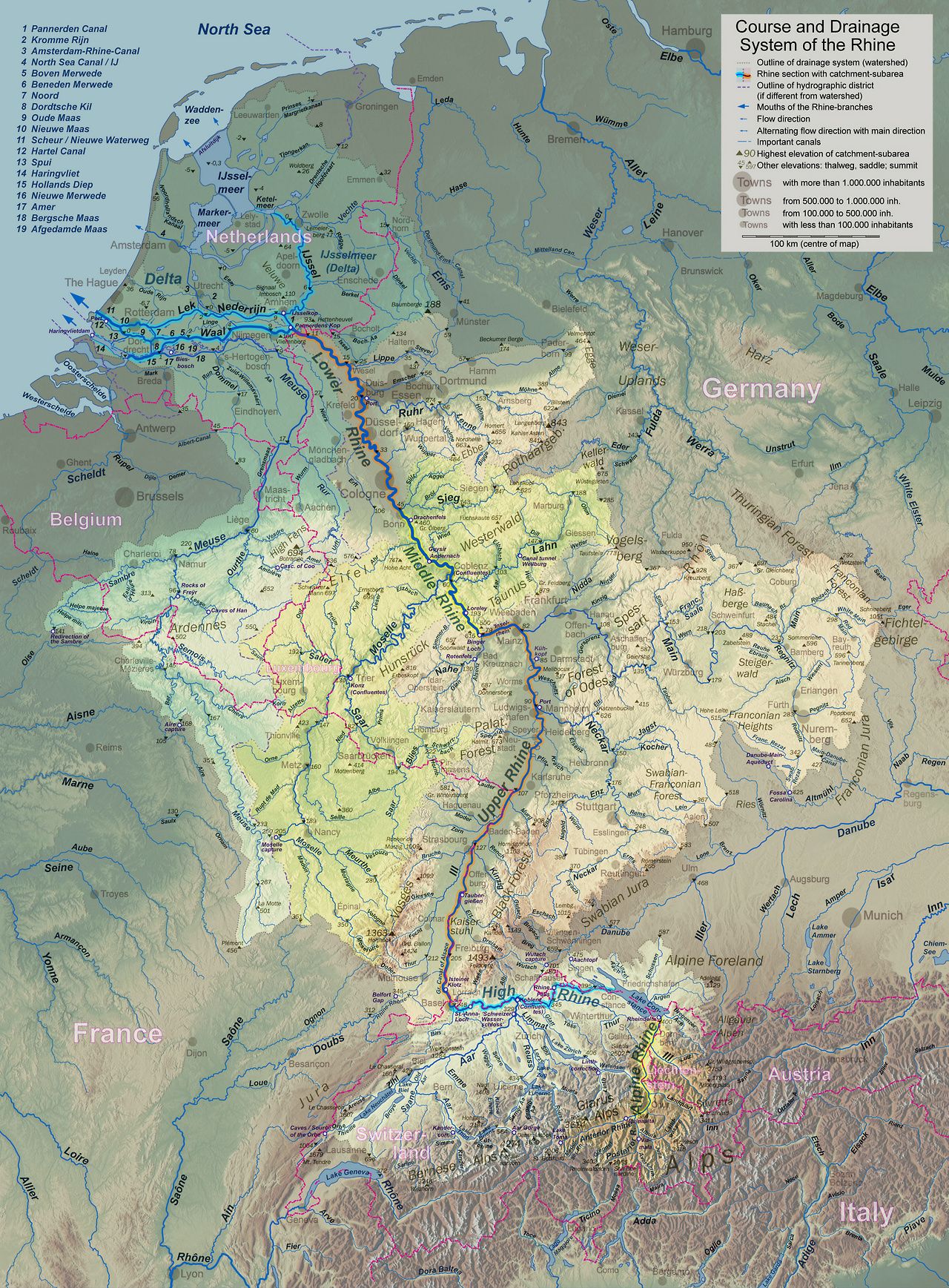
Rhine
 The Rhine links the Alps to the North Sea (click here for full, readable resolution). It is the main trade route north for Switzerland and Germany. The Netherlands owes its very existence to it: the country is largely the delta of the Rhine. At one point the Rhine was the northern border of the Roman Empire – an attempt to put the Roman border at the next river across did not fare well. The river remains a borderline to this day: it forms four international boundaries involving five countries. The upper reaches flow from the Alps to Lake Constance. After the lake, it becomes known as the High Rhine. At Basel it turns north, and the next stretch is the Upper Rhine. Later it becomes the Middle Rhine, the Lower Rhine and finally the Neder Rhine. Everyone wanted to name their own stretch. The last major diplomatic incidence in western Europe was when France decided to dump salt in the river, knowing full well that it was used for drinking water downstream. Rivers both connect and divide.
The Upper Rhine between Basel and Frankfurt follows an old rift valley. The Upper Rhine graben is 300 km long and 30-40 km wide. Strasbourg, one of the sites of the European Parliament, is in the middle of the rift. It is an extensional basin, and part of a larger, segmented old rift system that extends as far north as Oslo.

The rifting of the Upper Rhine graben was caused by the stress from the uplift of the Alps, and to a lesser degree by that of the Pyrenees. This happened something like 40 million years ago; the rifting mostly ended 30 million years ago but some movement continued until much later.
The basin has mountain ranges on either side, the Vosges and the Black Forest. The mountains are much younger than the graben. There are linear, segmented boundary faults on either side: the western Rhine Fault zone along the Vosges, and the eastern Rhine Fault zone along the Black Forest. The rift ends near the southern German border. South of it are the Jura Mountains, a beautiful linear chain along the Swiss-French border, a crumple zone pushed up by the Alps.
Basel lies just south of the Rhine graben and the Black Forest, southeast of the Vosges, and just north of the Jura. It has a view to all of these. But the view can spell trouble, as the Roman settlers soon found out.
AD 245
Having an empire is nice. It is good for your ego. It is less good for your security. It needs a lot of defending. Everyone wants a piece of the empire’s cake. Some see easy pickings for a raid. Others want their own empire. Some just want their original home land back. Some just want to trade. Some are looking for work, and others may be fleeing the chaos outside the empire. The natural solution is to create a buffer zone, but then you have to defend the buffer zone as well and that creates a new border on the other side, and so on. The Roman empire had a range of strategies to deal with the troublesome outsiders. They chose natural obstacles for the location of the border, made alliances with tribes near the border, and of course had a large army. They even build a wall. The most successful strategy turned out to make the outsiders insiders, and hand out citizenship. It created a land of the free, and gave people a reason to defend their inner freedom.
Emperor Augustus handled his border problems rather well. To keep the pesky northern Europeans (also known as barbarians) at bay, he had a scheme to secure the Alps as his border zone. Augustus ordered the development of three fortified settlements, located along the primary access routes into the empire. They were placed along larger rivers which were difficult to cross. It is hard to invade if your army can only get across in a small boat, one by one! to control the main river crossings. This channeled the outsiders to particular river crossings where the forts were waiting. The three settlements were Augusta Praetoria at Aosta (south of the Alps), Augusta Vindelicum on the Danube (at Augsburg), and Augusta Raurica on the Rhine. A certain ego-centricism may be noted in the naming. ‘L’etat, c’est moi’, he could have said had he known French.

Augusta Raurica was located on a river terrace on the southern side of the Rhine, 1 k from the river and 20 km east of modern Basel. The ‘Raurica’ name was local: this was the homeland of the Celts, and the Raurici were a Celtic tribe in a border alliance with the Romans. Augusta Raurica was in existence by 15 BC. The city overlooked the Rhine, was backed by the Jura mountains and had two small rivers on the west and east side. It was a very well devised defensive location. It was also a crucial location for traffic, as the main route through the Rhine graben ended here. Augusta Raurica became much more than a fort. It quickly grew to become a wealthy trading centre with a population of 20,000. The amphitheatre could seat 8,000!
But although it was well defended against enemy armies, it was not as secure against mother nature. Nature went on the attack when a powerful earthquake hit the city. It has been dated to between 245 and 255 AD. Interestingly, there are no written reports known of the earthquake. It is known solely from archeology. Excavation revealed devastation. There were many ruined buildings, collapsed columns, toppled section of walls with human skeletons underneath the rubble. Some quick repairs had been attempted, but these seem haphazard and they give the impression that effective government collapsed after the disaster that befell Augusta Raurica.

From Faeh et al, 2006, J Seismol 10:459–477
The earthquake left the city vulnerable. German tribes attacked the region in the summer of 260 AD. The Roman consul of Galicia defeated them, but not before they had destroyed what remained of Raurica (perhaps aided by rampaging Roman troops). The consul in question, Postumus, was an able but ambitious person with one eye on becoming emperor. The normal path to this was to take over a province, and take it from there. Postumus followed this route: after the battles left him in full charge, he broke away from the empire in 260 AD and ruled (quite ably) over modern France, Spain and Britain. This was bad news for Raurica. The ancient brexit stopped much of the trade on which Raurica had depended. In one triple blow, the city had lost its buildings, its security and its wealth.
The break-away territory became re-incorporated into the Roman empire by 274 AD, after the death of Postumus who never became emperor. This was too late for Raurica, and the city did not recover. Instead there was rebuilding in two nearby locations. A new fort was build: the location remained strategically important. But the wealth was drained from it and the population now lived in poverty. It takes peace to build prosperity. When the Roman empire vacated the area in 400 AD, the tribes that took possession occupied the two settlements. Over many centuries, these survived and eventually became the modern towns of Augst and Kaiseraugst. But all that remains of Raurica is an archeological site and a museum. It is a pleasant place to visit: the ruins are located within a park, with a trail that connects the various remains. But it is a walk into the past. After the earthquake, Augusta Raurica became history.
There is a pattern here. A single disaster is survivable. It becomes a drama when two (or in this case three) disasters hit in quick succession. The earthquake caused massive destruction, but it wasn’t irrecoverable. The recovery failed because of unrelated political events. It was an earthquake with bad timing.
How strong was the earthquake? A value of M6.9 is sometimes given (moment magnitude) but this has been questioned for several reasons. First, an event this size would have been felt wide and far, and one would expect that it was mentioned in multiple written documents from different locations – none are known. Second, one would expect earthquake scars in the landscape, but little has been found. (There is one sign: a fallen block of lime stone in the Battlerloch cave, 10 km southwest of Raurica, has been dated to approximately this period.) Third, the destruction was localized. The city was divided into the upper town and the lower town. Uptown was the centre with the major buildings, whilst downtown was where the workers lived. The recorded damage is only evident in the uptown: downtown shows little evidence for destruction.
(There are two provisos here. The downtown buildings were much more basic, and frequent rebuilding might have been required here anyway. This makes it difficult to assign any particular damage to the earthquake. And because Roman remains of this time are not common in the area, wider damage may have been missed.)
The difference in location between the upper and lower town is important. Uptown was build on the terrace overlooking the river. Downtown was build on a 10 meter thick layer of gravel. It turns out that the terrace amplified the shaking whilst the gravel did not. Thus, the uptown was subjected to a stronger quake than downtown. The rich came off worse. This amplification leaves the strength of the earthquake in question. An M6.9 may indeed not have been needed: models suggests that a much weaker but local earthquake could have caused the severe damage to the town. An M5.9 or M6.0 may have sufficed to end the story of Augusta Raurica.
AD 1356
While the Roman settlement of Augusta Raurica flourished, a nearby different settlement also existed. There had once been a Celtic village near modern Basel. Around 80 BC this unfortified settlement was abandoned and the people moved to cathedral hill (inside the modern city), protected by the Rhine and the river Birs, as well as by an earthen wall. Clearly, the settlement was experiencing raids and the people needed a better defense.
During the Roman era the main settlement was in Augusta Raurica, but apparent a separate Roman garrison was stationed at cathedral hill. It is not clear whether that included a fort, as is often claimed. After the destruction in Raurica the stability of the second location became an advantage. Emperor Valentian stayed here in 374 AD, and at this time the settlement was first called Basilia. Further development was slow and the settlement remained small. It overtook Augst (new Raurica) only when a long-distance road was developed in the Birs valley, around the 7th century. This left Basilia much better connected to civilization, i.e. to southern Europe. From here on, Basel would become the dominant town in the region.
By the 14th century Basel had grown prosperous, and cathedral hill had acquired a cathedral. It remained smaller than the old Roman town of Augusta Raurica had been: the population at this time was perhaps 10,000. Now, an eventful era came. In the summer of 1338, grasshoppers devoured the harvest. In July and August 1342 flooding reduced the harvest again. From 1345 to 1347 terrible weather caused famines. In 1349, the Black Death hit the city, with as side effect attacks on the local Jewish population who got the blame. In 1354, Basel was partly destroyed by fire. These were fairly typical disasters for a medieval town, but rather a lot of them happened close together.
The next one was not typical. On October 18, 1356, an earthquake swarm hit. The first jolt happened just after noon, soon followed by two weaker shocks. Around 5pm there was a stronger shock which caused people to flee their houses. That turned out to be a good thing. At 9pm a much bigger earthquake struck. This remains the strongest historical European earthquake known north of the Alps.

Source: wikimedia
Basel was now in a bad state. Reports state that it was utterly destroyed, but that should be taken with caution. Similarly, wikipedia’s claim that there was destruction from Paris to Prague badly misquotes its reference which only states it was felt in these locations. But the damage was major. The cathedral on the hill lost all five of its towers, and the nave vault collapsed. Two towers and the vault were later rebuild; of the other towers only some corner stones remain. Other churches were damaged. Many buildings lost their roofs, and walls were cracked throughout the city. A number of castles were destroyed, but we don’t know how many: various documents give numbers varying from 20 to 60. As an example, Madeln castle outside of Basel collapsed and was never rebuild. The ruined castles appear to have been located mostly south and southwest of Basel, 5-15 km away. Some buildings in Basel survived without major damage: of the 63 buildings that still exist in Basel which contain structures that date from before 1356, six show no indication of rebuilding or restoration from this time. But many of the oldest buildings were damaged, often severely. The buildings were those with irregular construction, thin walls and/or many openings in the walls. The strongest buildings included one monastery which indeed survived with little or no damage. Building standards matter.
It is not known how much of the destruction came from the 5pm quake and how much from the 9pm but it seems likely that the latter did most of the damage. The earlier earthquake may have helped to limit the number of casualties. There is no authorative number for those. Around 8000 people may have lived in the city and the surroundings after the black death: based on this, the number of 300 dead seems plausible, and the number of 2000 listed in later documents very unlikely. But contemporary records only name three people who died.
There was some damage in other regions. Bern, 80 km from Basel, lost a church tower, and had cracks in the city walls. North of Basel the earthquake was felt in Strasbourg. A church tower reportedly collapsed in Besancon, 100 km west of Basel but this report again should be taken with caution. The earthquake was felt at least 200 km away. But the majority of the destruction was in Basel, and the epicentre was likely near the city.
After the earthquake came the fire. This is common after destructive earthquakes, in modern times because of damaged gas lines, and in medieval times because of the open cooking fires in combination with straw roofs. The fire swept through the buildings inside the city walls, and affected especially a poorer region of the city.
Building construction changed after the earthquake. Much more use was made of brick: the fear of the shaking ran deep. But the city was not abandoned. Unlike Augusta Raurica, it was rebuild and Basel continued to prosper in its old location.
Modeling of the damage to buildings indicates that the earthquake had intensity IX. The Mercalli scale defines this as:
IX. General panic. Weak masonry destroyed; ordinary masonry heavily damaged, sometimes with complete collapse; reinforced masonry seriously damaged. Serious damage to reservoirs. Underground pipes broken. Conspicuous cracks in ground. In alluvial areas, sand and mud ejected; earthquake fountains, sand craters.
This corresponds to a surface acceleration of 0.5 to 1g. This intensity can be achieved at the epicentre of earthquakes of magnitude 6 or 7. The shaking strongly depends on local conditions and depth of the earthquake. Opinions differ on what the actual size was. The lowest estimate is M62, a common one is M6.6, but modeling of the buildings in Basel that date from before 1356 has suggested a moment magnitude between 6.7 and 7.1.
Other events
There are other reports of earthquakes in the Basel region, albeit less destructive. Not all reports are reliable: a large earthquake in 1021 is mentioned in 16th century writings, but we know from other documents that it occurred in Bavaria on Friday, May 12, and there is no indication that it affected Basel in any way.
A significant earthquake in 849 is mentioned in several monastery annals as a ‘terrae motus’. The event happened in the early morning of Saturday April 20; the aftershocks continued until June 1. It was reported in Reichenau, well east of Basel in the Rhine valley near Lake Constance. But there is no evidence that it affected Basel.
Other but weaker earthquakes have been reported in Basel in 1357 (likely an aftershock), 1428, 1572, 1610, 1650, and 1682. The Mercalli intensity of these reached VII, corresponding to perhaps magnitude M5.5. Such an earthquake can damage poorly constructed buildings and bring down chimneys, but it should not cause major damage. But after 1682, all went quiet. Nowadays the region has earthquakes of M4, but the larger ones of the past have long been left behind by living memory.
Large earthquakes should leave a memory in the landscape,. One may expect disturbed sediment layers in lakes. Indeed, five earthquake-induced layers have been found by drilling into local lakes. They occured after 12,000 BC: before that time the ice-age glaciers still ruled. The assigned dates are (approximately): 180–1160 BC, 2900–3850 BC, 4870–5660 BC, 8260–9040 BC and 10,720–11,200 BC. The reason for the fairly large uncertainty on the dates is that sedimentation rate in the lakes is very low, at 1 mm per year. The dates are based on radiocarbon dates of material just below and just above the disturbance, and a small offset gives a large difference in time. Earthquakes of the past 2000 years are not easily detected, both because of the slow sedimentation rate and because of human disturbance. One lake was even drained 700 years ago, an unexpected scientific setback.
These older events are expected to be similar in size to 1356. Together with the 245 AD and 1356 AD earthquakes, this indicates 7 significant earthquakes in the past 14,000 years, or a recurrence time of two thousand years. One should be careful with this phrase. It is reasonable to assume that we will need to wait this long for the next one if all earthquakes happened on the same fault: it will take this long to build up enough stress. But if multiple faults are involved, then an earthquake can happen at any time and talking about a recurrence time gives a false sense of security. In that case it is is better to just state it as seven big shakes in 14,000 years, or a chance of 1 in 20 per century.
Faults of Basel
The builders of Basel were no aware how faulty the region was. There is quite a choice regarding the fault or faults that caused the two large earthquakes.

Source: K. Ustaszewski, S. Schmid, 2007, Bull. angew. Geol, 12 https://tecto.earth.unibas.ch/Members/Schmid/Publications/104_Ustazewski&SchmidBullAngGeol2007.pdf
The tectonics in the area is dominated by two big structures. The Rhine graben has already been mentioned. It runs north-northeast from Basel, and with fault zones on both side of the graben. The zone on the west side, bordering the Vosges, is quite far from Basel and is probably in the clear. The fault zone on the east size, bordering the Black Forest, is much closer with two of its faults on either side of Basel. This has always seemed the most likely cause, but there are problems. The faults have notable escarpments north of Basel, but escarpments are not visible around Basel or further south. There is little evidence that these faults are active closer than around 20 km north of Basel. And the northern region seems excluded for the Basel earthquakes. The destruction of castles happened mainly south of Basel: only two of the ruined castles were located in the Black Forest.
This moves the attention to the Jura. It is a classic thrust-fold structure, where the surface has been pushed up and forward, forming folds. Blame Italy for this – the Jura are forced by the Alps which are forced by Italy wanting to join Europe. It is the geological version of the Roman empire! The layer that is on the move consists of Jurassic (there is a clue in the name ‘Jura’) sediments that lie on much older rock. The base rock isn’t moving: the sediment has detached from it. The detachment fault lies a few kilometers deep.
The Jura has been thrust against the Rhine valley, and it is the cause of the 90 degree bend of the Rhine. If it moves much further it could cut off the upper Rhine from its head waters. If it is still moving. Could this thrust fault be responsible for the 1356 earthquake? It lies in the area of the likely epicentre. But the detachment is quite shallow here and any major movement should have left signatures at the surface. None are seen. River beds show some discontinuities which indicate there has been some movement here in the past few million years – but hardly enough to worry Basel.
A third option is that the basement rock itself has failed. It also is under pressure from the Alps, and it dates from an older era of mountain building which may have left ancient faults. These may have been re-activated by the Alps. However, there is no evidence for uplift associated with such a fault.

From Ferry et al 2005. https://doc.rero.ch/record/289518/files/160-2-554.pdf
A fourth option is that the cause of Basel’s demise was the very valley that once gave it its future: the Birs river valley. The Birs is the main river running north from the Jura, running through a notable valley to Basel where it becomes a tributary to the Rhine. The main town along the Birs is Reinach. The valley has an escarpment on the west side that could indicate an active fault. Investigations along this escarpment have shown evidence for recent movement with a total uplift of 2 meters. The uplift happened in three different events: the most recent has a C14 date between 610 and 1475 AD, not inconsistent with the 1356 event. The landscape indicates that over the past 250,000 years, there has been 35 meters of uplift along the fault.
The visible part of the Basel-Reinach fault is too short (8 km) to explain an M6.5+ earthquake, but the fault may extend underground, south underneath the Jura, and north underneath Basel. This would give a maximum length of 15 km. It lies in the direction of the Rhine graben and may be connected to it. It is a strong candidate for the Basel earthquake!
The escarpment near Bruderholz, a hill and Basel suburb known mainly for a battle between Swiss and Swabian troops – in 1499! The Swiss won (which is probably why this battle is remembered – our memory is much better for success than for failure). The Swiss battled raiders, but to be fair they had been raiding themselves and were on the way home when meeting the invaders.

Reinach memory
The Basel-Reinach fault is a plausible cause for the 1356 Basel earthquake. But the other faults have not been ruled out. And if the Basel-Reinach fault extends over the full 15 km, it intersects the other faults. A failure of multiple faults cannot be excluded. The fact that there were multiple earthquakes with foreshocks in 1356 makes it possible that multiple faults were involved, in a cascade of faulting.
The bottom line is that founding a village is much like buying a house: do check for faults.
The Basel-Reinach fault comes within 7 km of Augusta Raurica and is also a strong contender for the 250 AD event. In fact, any of the discussed faults could have done it. But there is yet another option. It turns out that the terrace on which the upper town of Raurica was located has a buried graben. This SSW-NNE trending graben was recognised from borehole data: it may be related to the plethora of short faults south of the Black Forest. The graben is bordered by two faults, and the eastern fault of this graben runs directly underneath the centre of Raurica. An earthquake on this fault of M6.0 or 5.9 would have been sufficient to destroy the upper town or Augustus Raurica.

Augusta Raurica. The dashed black line indicate the border fault of the buried graben.
And the next one?
If only the Basel-Reinach fault is responsible for earthquakes around Basel, then the recurrence time is likely around 2000 years and Basel has plenty of time to prepare. Too much time, probably: politicians are not easily interested in events more than one election cycle in the future. All politics is short term. After all, the children who may be affected can’t currently vote – politicians who chase the children’s votes tend not to do well. But if more faults are involved, then the recurrence time cannot be used to predict the next event, as a different fault may fail next. In that case, the next such earthquake could happen at any time. That raises (or rather uplifts) the question: How well prepared is Basel?
A sobering assessment done in 2012 suggested, not that well. The assessment modeled an M6.6 earthquake near Basel, and predicting significant impacts:
- Between 1,000 and 6,000 fatalities
- 60,000 injuries
- 1,600,000 people homeless in the short term (yes, you noticed that right: for some reason it is twice the number of inhabitants)
- damage to half of all buildings, with property damage exceeding 50 billion of that most stable of currencies, the Swiss Franc.
Such an event could seriously damage Switzerland’s stability, serious enough to expect that the politicians will go for the political solution: decide more study is needed. After all, it may go away.
A volcano mystery
The Basel earthquake came after a difficult decade. The floods of 134 have been discussed elsewhere. The poor weather that followed was not just anecdotal: from tree rings we know that the summers of 1345 and 1346 were exceptionally cold. Ice cores have shown a sulphate peak that points at a volcanic eruption in 1345. The peak is seen equally in both hemispheres, we know it was tropical volcano.
Shortly afterwards, the black death appeared. This was not the first time: 800 years earlier, the Justinian plague which devastated Europe, came after extreme weather caused by not one but two major eruptions. Which volcano kicked off the 14th century pandemic is not known. The earthquake had nothing to do with the eruption and pandemic. It just happened at just that time.
The 245 earthquake came at the start of a bad time. The 1356 earthquake came at the end of a bad decade. Disasters rarely strike in isolation. They hunt in packs.
Stability
Let’s give the final word to Tevye, who knew something about the importance of stability and the dangers of earth-shaking events.
A fiddler on the roof. Sounds crazy, no? But here, in our little village of Anatevka, you might say every one of us is a fiddler on the roof trying to scratch out a pleasant, simple tune without breaking his neck. It isn’t easy. You may ask ‘Why do we stay up there if it’s so dangerous?’ Well, we stay because Anatevka is our home. And how do we keep our balance? That I can tell you in one word: tradition!
But tradition does not give protection. Switzerland, with its tradition of stability, should also remember its history, and should not forget its faults. It may yet be shaken again.
Albert, April 2021


Interesting article, Albert….and a great history lesson that I was totally unaware of.
That was something.. Directly hit on my interests. Need to be read again in evening. Just now with my nose in garden planting in greenhouse. Big thumbs up Albert.
Very interresting article! Never knew much about this area, so thanks for this!
And here’s me thinking Basel is a sleepy European town. Many thanks for a fascinating article!
Some of the most beautiful scenery is caused by faults. You make history come alive, Albert, well done.
I hopes to visit the eruption soon…
It will be an awsome sight… like walking on Jupiters moon IO s lava flows… they are exatcly the same… every dark spot on IO is basaltic lava flows and materials
https://www.youtube.com/watch?v=OaFmvdbff-8
Loki Patera… since it haves Icelandic nameing roots… : )
Today is a special day, so I took the liberty of pushing out a non-eruptive, non-volcanic (almost), non-icelandic post. It is exactly 66 years since Albert Einstein died. It also happens to be my birthday. Cheers!
If you would like to read more about events mentioned in this post, please see https://www.volcanocafe.org/the-1342-st-mary-magdalene-flood/
…and 78 years nearly to the day (was it the 16th or 19th?) since another scientist Albert took a famous bicycle ride!
…in Basel nonetheless!
Happy Birthday!
https://sketchfab.com/3d-models/geldingadalir-volcanic-eruption-18042021-439e33653b8142e3b7039d15c2d8bae2?fbclid=IwAR1ECmOhcs14Puiiyj0vtXhGNofZFZlWTXkqbL8ywZb7wRcAxZCCgn6TaPI
Happy birthday and a New Model of the lava flows
Good to see. Thank you Jesper. I hope they fix the Meradalir cam in time for us to see the lava flowing down in to the Meradalir plain from the Vent 1 and later vents flow on the left hand side of the camera.
Congratulations!
Oh just in time.
Van harte proficiat Albert!
That is a very impressive cake.
It is a cake, right?
Happy birthday.
Thank you for all your great posts and descriptions.
I try to autotranslate it 😶 my english almost not exist.
Thank you once again and keep doing this.
Happy birthday Albert.
I didn’t know it, but you are 2 years to the day older than I am.
Congratulations! And enjoy the eternal youth!
then i’m old enough to be Your Mother (both of You)…. 😉
We promise to behave. Some of the time.
To be clear ,Mom, if anything goes wrong….
(in the best traditions of younger brothers everywhere)…
He did it.
It is not true! He broke Reykjanes, not me!
Happy Birthday, and thanks for the article! Very interesting.
The 2017 quake swarm was oriented along a south-west to north-eastern zone that crossed our present event location:
Now, I’m too much of a non-expert to even guess what this could mean for the magma location and movement. But maybe you guys can read the following apparently new paper and say more?
https://www.sciencedirect.com/science/article/pii/S0012821X21001345
Don’t want to post too many pics from the paper, but this is very interesting indeed: The paper proposes a possible magmatic dike, guess where? Exactly! The spot where the quake’s foci are missing is our event location.
I agree, this is interesting, that the quakes cut across the rifts and also high light a “possible’ dike which now has been shown to be true. This paper makes me wonder if we should be on the alert to the west for the next new fissure line. Lately the lava flow from the fissure cones seems sluggish, the southmost cone has changed to emitting lots of smoke (steam? sulfer dioxide? both?)
Now, if you look at the article (which is open access, BTW) you will see:
Received 16 October 2020, Revised 11 February 2021, Accepted 3 March 2021, Available online 1 April 2021.
The article was accepted on March 3rd, well before the eruption occurred. Therefore, the authors can claim to have predicted the presence of the magmatic dyke before the eruption has proven them right. That’s an excellent validation of their work!
Happy Birthday, Albert, and thank you for another fascinating article!
Happy Birthday, Albert!
You are the Gift!
Thanks for Everything!
All the Best! for all the rest of the days until the next birthday!
It’s your Birthday? Thank you for making an article not related to Reykjanes and Happy birthday
Happy Birthday Albert.
Happy birthday Albert, and thanks for yet another great article.
In regard to dike formation, I came across this high-school experiment using jello to simulate a volcano but it is very interesting to see the sudden dike formation in the jello and to see that a thin split is created which is rapidly filled by the ascending magma.
https://www.iris.edu/hq/inclass/video/gelatin_model_of_magma_intrusion_intrusive_vs_extrusive
[for some reason, the audio becomes monaural, hopefully not too disconcerting]
Nice!
Happy Birthday Albert!
A very sad news…
My thoughts and prayers go out to the staff and students at my Alma Mater
@UCT_news
. I am devastated to hear of today’s fire which has engulfed the campus and destroyed historical buildings including our rare collections library. Heartbroken.
https://twitter.com/tarryn_sport/status/1383867765723865092
The University of Cape Town’s library and residences and upper campus building are currently burning as firefighters battle to contain the fire on the slopes of Table Mountain . #capetownfire
I know the place well. It is very bad news
This is so so sad!!! But it seems the most precious books are saved…
Dan Reece@DanReece9
(2) APPARENTLY the most valuable contents of the library were saved in underground fireproof vaults. Obviously it’s still sad to lose the other contents that was above ground though
Phew. But a lot will be lost, in buildings, research, and teaching. It is the fire season. I noticed the wind is northwest. Is rain coming?
Yes it was a terrible fire in Tablet mountain… all this is soo sad! Soo much lost! Just incredible!
Such a devastating loss.
Such a beautiful part of South Africa.
But I do recall that bushfires were fairly commonplace when I was there.(In South Africa… I only ever spent 4 days in Cape Town.
Test
At 21:30 a yellow-orange spot opened up to the south of the southmost cone, but not sure if this is just lava flow or what? See https://www.ruv.is/sjonvarp/beint/ruv2
Question for Dragons: I have registered for the site. I can post messages when logged in but not ‘Likes’ unless I login using my other WordPress account? Did I miss something? Thank you.
Oh, Firefox Win10 PC. – Exceptions granted for site.
Me too, explain please?
Also it now keeps asking me for name and email add, every time I post.
I have the same. I cannot give likes with my account I made here on VC. I have to open a separate WordPress account to start my own WP-blog first before I can use the like button here.
It has always done that for me too. So I never bother with the likes.
Southy looks like showing signs of life again
okay, more vigorous activity of all the cones, with the southmost cone apparently blowing off the ceiling debris and opening back up started around 21:35 and is continuing as I write.
Haven’t read the article yet, just skimmed the top part, seems interesting.
And here’s a brand new 3D image thingy of the eruption site https://sketchfab.com/3d-models/geldingadalir-volcanic-eruption-18042021-439e33653b8142e3b7039d15c2d8bae2
Happy Birthday a bit late Albert. Thank you for that interesting read and history lesson. And I thought Switzerland was a neat, tidy and thoroughly organised place, but it seems , like their cuckoo clocks, the accuracy and sophistication of their logical workings can be given the bird!
My PC erupted with a bang! Bro in law is an IT specialist so he’s got me an old tower and my info now installed in it but no sound… Tomorrow I hope he can fix that. (I done all I can except trace the speaker wires to see if he actually has plugged them in! I need to be a contortionist to do this as the tower is a monster and I can’t move it!)
Happy Birthday Albert!
the ruv2 cam it’s alive and guess what…re alocated…
Happy birthday to you Albert! I loved the article.
Another eruption of #LaSoufriere in #StVincent.
https://twitter.com/TTWeatherCenter/status/1383906253341036549
A bright night — is it full moon?
MILA cam:
we are moving toward the “White Nights” of summer.
Its all snowed over now 🙁
Happy Aging Day Albert!
Seems that RÚV decided to give you the birthday present of getting the Meradalir can bank online
The new cam has a strange view. My only explanation is that it is not placed in Meradalir, but north of the inactive #2. That way you see the #2 cone on the left and all other vents in a row. Does this make sense?
They install it onto the fissure with a view toward keillir…maybe they expect smth…
Sorry…toward south….and that will be natthagi valley…
Many happy returns, Albert!
nice telescope Albert! Congratulations for another solar orbit completion!
New Timelapse montage is in the process of beingn uploaded, and should be available in a few minutes: https://youtu.be/NDGQS0g536k
https://www.ruv.is/sjonvarp/beint/ruv2 shows a hot area underneath the leftmost cone 2:45 am.
I have been watching it for 5 or 10 minutes, perhaps a lava pond breakout?
Testing to see if I can comment.
I visited Basel a few times in the 1990s. Usually to attend the watch and jewlry fair. I remember when watching building construction. I remarked that I suspected they did not have a lot of earthquakes. I seem to recall someone saying that yes they did but such were quite rare.
A video of today’s La Soufriere eruption. Also ash blowing about in the wind, and narrative.
Test from Quebec (Canada)
[Freed from the claws of out guard dog Akismet / Lugh]
Thanks for this exciting mix of history and geology. And happy birthday!!
Happy level-up day Albert!
Looks like the lava has decided to turn south after the exit, instead of into Meradalir(though that will no doubt happen soonish)

Looks like it has a grasp of the highway code, it is following the track nicely!
It will get drunk later and crash off to the side…
A question- has any of the vents shut down as yet?Am getting an impression some have,but have no way knowing. Thanks.
There were some of the initial vents that disappeared. But from the two that were left, lava is still pouring out, even if there is a lot of smoke and quite small flow from the southern (higher) one.
Thanks JanB for that- ever changing stage it is!
The new “Meradalir” cam shows #2 in front. It seems to be down.
So, if I’m not mistaken, the area to the left of the nearest cone (vent #2) is to the north of the current eruptive vents. As I type this (11:35 UK) It looks like the recent snow has not settled along a line heading left/north of the vent but has settled on the lower ground nearer to the camera. Obviously many factors could be at play here but I would like to believe that the ground is warmer due to the closeness of magma in the dike and that a new northerly vent could appear on this line somewhere.
It’s interesting that the snow melt could show where magma is close to the surface – if only we could see further left/north and from a little higher up!
I haven’t seen anything from No. 4 for a few days.
Anyone lost a dragon?
https://imgur.com/bahX0bZ
Oops
https://i.imgur.com/bahX0bZ.jpeg
Test from Germany…….
Nice Read Albert, just like every time. Keep em commig
I think RUV need to change the location identification of the 2nd camera as it obviously is no longer looking over Meradalir
Aye, it is located north of vent #2, looking more or less south. Strange choice of a location for a new cam, unless a new fissure appears north of #2.
Source: “Map.is”, with the red spot just my rough guess of the new cam position.
Bingo. RUV has changed the video’s title to “Langhóll” .
Maybe they positioned this webcam so that it might catch any new fissures should they open up in that direction. However, it could be risky if they put it too close…
Langholl should be well enough away from the dyke to avoid risk.
Happy birthday Albert 🙂
Now we have an article that isnt about a specific volcano, I can finally point this out. Just today Kilauea had a swarm of shallow quakes right underneath Halemaumau, and over the past month up until about a week ago there were a lot more deep earthquakes than usual under its summit. Lava lake there is still active but it is a rootless lava lake, so unlike in 2018 the only pressure outlet is still a small vent that might be constricted at depth given the very low effusion rate and overall inflation of the summit. I think we might see a proper eruption from it soon, a high fountain 🙂
Mauna Loa is looking pretty serious now too, definitely more advanced runup to an eruption than before and theres a lot of quakes on its east flank at the depth of the decollement fault. Part of me wants another 1950, the closest thing we have to Laki on camera, though it will be apocalyptic if it erupts that way in Ocean View…
(Could someone delete this one it was an accidental copy)
The events to the December eruption began with slippage on the flank of Mauna Loa. And we had a new slippage event a few weeks ago, not in the same location but on the same side. So perhaps this will put more squeeze on Kilauea
Happy birthday Albert 🙂
Now we have an article that isnt about a specific volcano, I can finally point this out. Just today Kilauea had a swarm of shallow quakes right underneath Halemaumau, and over the past month up until about a week ago there were a lot more deep earthquakes than usual under its summit. Lava lake there is still active but it is a rootless lava lake, so unlike in 2018 the only pressure outlet is still a small vent that might be constricted at depth given the very low effusion rate and overall inflation of the summit. I think we might see a proper eruption from it soon, a high fountain 🙂
Mauna Loa is looking pretty serious now too, definitely more advanced runup to an eruption than before and theres a lot of quakes on its east flank at the depth of the decollement fault. Part of me wants another 1950, the closest thing we have to Laki on camera, though it will be apocalyptic if it erupts that way in Ocean View
Perhaps not as large as 15km3
But a large Mauna Loa event coud have eruption rates of many 1000 s of cubic meters a second perhaps up to 11 000 cubic a second.. basicaly a hell flood .. and hells lava tsunami comming downhill… superfast superfluid smooth turbulence sheet channel flows .. feeding huge kilometer wide Aa fronts downhill .. really scary.. the ocean entry forms a steam cumulunimbus
As I said im my criticism of the VEI scale, its all about intensity. We forget also that Laki was a months long event, it was a massive eruption but a long one too, so was Eldgja, and very probably also Veidivotn and Vatnaoldur. Mauna Loa in 1950 erupted a bit less than 0.4 km3 of lava, not a lot in comparison, but it did most of this in less than 2 days…
I read the original report, basically all of the flow field was set up on the first day, and only the lowest altitude vents were erupting lava by the second say in any volume. 300 million m3 in a single day, 3500 m3/s for a whole day, basically this is like a VEI 5 effusion rate for a lava flow. There is probably no eruption more deserving of the title of ‘lava flood’.
That sounds downright scary, particularly if it is just uphill from your housing estate.
In fact I underestimated, according to the data on the actual HVO page for the eruption the entire fissure opened in 2 hours, a 22 km long curtain of fire. All of the major flows were also erupted by midday on June 2, 15 hours after the start, and only the lower half of the fissure was active at all after daybreak on that day. Probably close to half of all the lava was erupted in only about 6 hours, at a rate of over 8000 m3/s…
There has only been one eruption in the 21st century with a higher intensity and that was Kelud in 2014, nothing else is even close, explosive or otherwise…
A very interesting piece with lots of historical details, I enjoyed the reading. I am only missing that the Graben system is said to continue west and south in the Bresse and then Rhone valley which might explain the damage in Besançon. The Jura is right between those two Graben systems
It is not the same graben, I think, but it is part of the same larger system of rifts that extends from Spain to Norway.
Belated birthday greetings Albert..as always, a fascinating read. Thank You!
https://twitter.com/TTWeatherCenter/status/1384087639117033474
The UWI SRC is now advising that #LaSoufrière’s pattern of seismic activity over the last few days is typical of the growth and destruction of lava domes. More explosive eruptions can occur.
Looks like data will be back any second from the chopper on Mars!
And it flew! Well done NASA.
Only had time for the comment section right now. Happy Birthday! Great cake.
On topic.
The rivers nothwest of the Alps show an interesting change in watershed.
In Miocene period the Rhine didn’t get any water from the Alps yet, it was a minor riversystem well northwest of the Alps but the catchment area grew and is growing.
Most of the northern Alps water was caught by the Donau then, flowing into the Black Sea. By the thrust of Italy (before the Rhinegraben was formed) the pattern changed and water in the northwest Alps was caught (near Basel) by the Doubs/Saone/Rhone system and flowed in the Mediterranean Sea.
By forming of the Rhinegraben and further upthrust of the Jura, the Rhine expanded its catchment area and stole the Aare system from the Doubs; in future part of the upper Donau will probably be added to the Rhine too.
Maps from
https://aarelauf.ch/flussgeschichte-der-aare/
Wow. And thank you.
Sadly, my tolerance for German never recovered from translating complex Late-19th Century syntheses from post-fix ‘Technical’ writ in ‘Gothik Fractur’ to in-fix English. Each was three (3) sentences: A brief intro, a lonnnng page of mega-compound terms with all the verbs at the end, and a brief conclusion. Think ‘Cryptic Sudoku’, each translation usually taking longer than the arcane synthesis it described…
Back on topic: Looks like that area’s drainage has switched as often as those North American watersheds in Great Lakes region and to West…
( Yes, yes, I’ve a secret hankering to see rising Hudson Bay’s 2nd-order isostatic rebound tip Lake Michigan Southwards into the Mississippi catchment… 😉 )
I note a large lake parallel to Alps ~20 My: Did it drain progressively, or do ‘Missoula’ mega-flood(s) ?
FWIW, is there any connection between Basel graben and the Eifel volcanism, or is that just another aspect of the complex faulting from Iberia to Norway mentioned ??
I don’t think they did a flood, I am not sure, but believe it filled slowly with sediment from the Alps and was uplifted at the same time. I have some rocks from the Basel area originating from the Vosges, north from Basel, so sediment came also from northern parts.
Massif Central(Clermont Ferrand), Vosges, Black Forest(?), Hünsrück and Eifel form a chain (active in a long lasting period) along a fault that is considered to be a next break away from the European continent in far future. Has this event a link to the thrust of the Alps? Don’t know, not directly I think. But amateur writing here!
Gollum vent lava lake is very low again, I think we might see a new vent soon 🙂