Late in 2020, an M6.4 earthquake struck the town of Petrinja in Croatia. It caused extensive damage in the town and in nearby villages, and 7 people died. Even so, the impact was more limited than it might have been because houses here tend to be well build. It came as a surprise: powerful earthquakes are infrequent here. But there was precedence. A similar event had taken place 140 years earlier 30 km away, in Zagreb.
140 years is a long time. People don’t remember what neither they nor their parents have seen. It is not part of their living memory; events 5 generations ago seem an irrelevance to our lives. History is forgotten until it is repeated. Isn’t this true of the current pandemic as well? Current events are almost a copy of the 1918 Spanish flu, spread from the US by the movement of soldiers across the world. We had forgotten.
Petrinja is not a large town. It is important only to those who call it home. It is an Anatevka, a small place within a much larger world. Anatevka is the fictional shtetl (Jewish township) of Fiddler on the Roof. The movie and the musical that came before were based on Sholem Aleichem’s story, Tevya the milkman. Tevya and the other people who live in Anatevka are subject to powers outside of their control, forbidden to move and suffering frequent progroms. They are strangers in a strange world, subject to every whim of the home office. The lack of power of the local people is described brilliantly in the movie: “If the rich could hire others to die for them we, the poor, would make a nice living”. The movie is about how tradition imparts stability to their powerless lives. As Tevya says, “without traditions our lives would be as shaky as a fiddler on a roof.” But tradition also causes inflexibility, and when the pressure grows something has to give. Tevya begins to see how traditions have to change with the times. “Our old ways were once new, weren’t they?”. He manages to break free of part his own traditions, but Tevya is unable to complete the journey. His world remains shaped by history and traditions. The movie was so successful because it is true to our own lives. All of us live in a world shaped by culture and parents. We see the world through highly coloured glass, and this gives comfort and stability. It is what makes volcanoes so difficult to live with: they can change our world irreversibly, and without warning!
Traditions seem forever, but in reality are rarely more than 2 or 3 generations old. The world changes too rapidly for that. An earthquake 140 years ago leaves us no traditions. They do leave stories. Stories can long outlive traditions, and pass on knowledge from a world lost to memory. Stories can last thousands of years. But without context, their meaning becomes lost and the stories no longer carry a warning.
Although Anatevka is sited in the Ukraine, Fiddler on the Roof was actually filmed in Croatia. The Anatevka of the movie is Lekenik, just 15 kilometers from Petrinja, halfway to Zagreb. In fact, Lekenik lies midway between the two most damaging earthquakes in Croatia of the past centuries. When the earth moves, people have to move too.
An earthquake in Anatevka would not have left lasting effects. The fictional town was created to be insignificant. An earthquake in a capital city would be a different story. Petrinja reminded us that one of Europe’s capitals, Zagreb, once suffered a damaging earthquake. But is this unique? Which other cities in Europe could be in danger?

Earthquake risk in Europe. The colours indicate the maximum ground acceleration expected over 500 years, with 1g as maximum. Source: https://www.e-periodica.ch/cntmng
There are obvious candidates. Turkey’s capital Istanbul has a history of major earthquakes. Portugal’s capital Lisbon was once destroyed by an earthquake that caused the economic collapse of its empire. The worst earthquake known in European history was in Messini in southern Italy, as recent as 1908: it left over 50,000 dead. Naples is at risk, but Naples is at risk of many things. The locals seem not to worry about. I love the city and its people but despair about their attitude. Cyprus is at risk of major earthquakes. So far, all well-known and recognized localities – and all are on the coast. But there is another place like Zagreb, deep in-land, far from obvious fault lines but with a shaky history. And unlike Zagreb, it was destroyed by earthquakes not once but twice. Welcome to Basel.
Basel

Perhaps this is the most international city in the world. It lies on the river Rhine, and has a foothold in three different countries. The city itself is in Switzerland, but it has suburbs in both France and Germany. Each of the three countries has its own railway terminal in the city centre. The city has 180,000 inhabitants; over 800,000 people live in its vicinity. Basel has a reputation as a very livable city, at least according to the wikipedia article which seems to have been written by the Basel advertisement agency. The article only mentions one earthquake, and does so only in passing. Some things are best forgotten.
The city started out on the southwest side of the Rhine but it now is on both sides with five bridges; the oldest bridge dates from 1255. Basel is located where the Rhine makes a 90 degree turn and begins to flow north, in between the Vosges and Black Forest mountains. The story of the city is closely linked to that of the river.

The oldest of the 5 bridges
Rhine
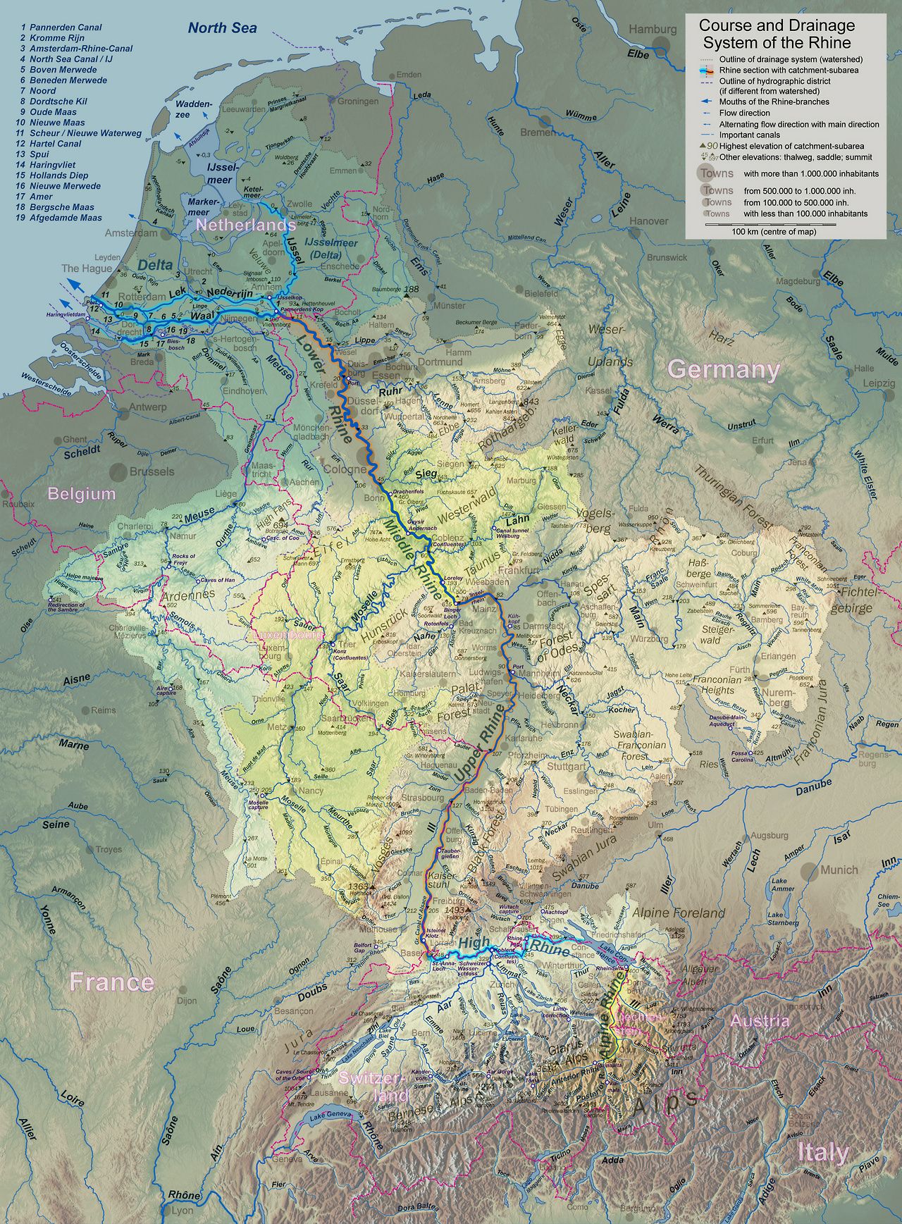
 The Rhine links the Alps to the North Sea (click here for full, readable resolution). It is the main trade route north for Switzerland and Germany. The Netherlands owes its very existence to it: the country is largely the delta of the Rhine. At one point the Rhine was the northern border of the Roman Empire – an attempt to put the Roman border at the next river across did not fare well. The river remains a borderline to this day: it forms four international boundaries involving five countries. The upper reaches flow from the Alps to Lake Constance. After the lake, it becomes known as the High Rhine. At Basel it turns north, and the next stretch is the Upper Rhine. Later it becomes the Middle Rhine, the Lower Rhine and finally the Neder Rhine. Everyone wanted to name their own stretch. The last major diplomatic incidence in western Europe was when France decided to dump salt in the river, knowing full well that it was used for drinking water downstream. Rivers both connect and divide.
The Upper Rhine between Basel and Frankfurt follows an old rift valley. The Upper Rhine graben is 300 km long and 30-40 km wide. Strasbourg, one of the sites of the European Parliament, is in the middle of the rift. It is an extensional basin, and part of a larger, segmented old rift system that extends as far north as Oslo.

The rifting of the Upper Rhine graben was caused by the stress from the uplift of the Alps, and to a lesser degree by that of the Pyrenees. This happened something like 40 million years ago; the rifting mostly ended 30 million years ago but some movement continued until much later.
The basin has mountain ranges on either side, the Vosges and the Black Forest. The mountains are much younger than the graben. There are linear, segmented boundary faults on either side: the western Rhine Fault zone along the Vosges, and the eastern Rhine Fault zone along the Black Forest. The rift ends near the southern German border. South of it are the Jura Mountains, a beautiful linear chain along the Swiss-French border, a crumple zone pushed up by the Alps.
Basel lies just south of the Rhine graben and the Black Forest, southeast of the Vosges, and just north of the Jura. It has a view to all of these. But the view can spell trouble, as the Roman settlers soon found out.
AD 245
Having an empire is nice. It is good for your ego. It is less good for your security. It needs a lot of defending. Everyone wants a piece of the empire’s cake. Some see easy pickings for a raid. Others want their own empire. Some just want their original home land back. Some just want to trade. Some are looking for work, and others may be fleeing the chaos outside the empire. The natural solution is to create a buffer zone, but then you have to defend the buffer zone as well and that creates a new border on the other side, and so on. The Roman empire had a range of strategies to deal with the troublesome outsiders. They chose natural obstacles for the location of the border, made alliances with tribes near the border, and of course had a large army. They even build a wall. The most successful strategy turned out to make the outsiders insiders, and hand out citizenship. It created a land of the free, and gave people a reason to defend their inner freedom.
Emperor Augustus handled his border problems rather well. To keep the pesky northern Europeans (also known as barbarians) at bay, he had a scheme to secure the Alps as his border zone. Augustus ordered the development of three fortified settlements, located along the primary access routes into the empire. They were placed along larger rivers which were difficult to cross. It is hard to invade if your army can only get across in a small boat, one by one! to control the main river crossings. This channeled the outsiders to particular river crossings where the forts were waiting. The three settlements were Augusta Praetoria at Aosta (south of the Alps), Augusta Vindelicum on the Danube (at Augsburg), and Augusta Raurica on the Rhine. A certain ego-centricism may be noted in the naming. ‘L’etat, c’est moi’, he could have said had he known French.

Augusta Raurica was located on a river terrace on the southern side of the Rhine, 1 k from the river and 20 km east of modern Basel. The ‘Raurica’ name was local: this was the homeland of the Celts, and the Raurici were a Celtic tribe in a border alliance with the Romans. Augusta Raurica was in existence by 15 BC. The city overlooked the Rhine, was backed by the Jura mountains and had two small rivers on the west and east side. It was a very well devised defensive location. It was also a crucial location for traffic, as the main route through the Rhine graben ended here. Augusta Raurica became much more than a fort. It quickly grew to become a wealthy trading centre with a population of 20,000. The amphitheatre could seat 8,000!
But although it was well defended against enemy armies, it was not as secure against mother nature. Nature went on the attack when a powerful earthquake hit the city. It has been dated to between 245 and 255 AD. Interestingly, there are no written reports known of the earthquake. It is known solely from archeology. Excavation revealed devastation. There were many ruined buildings, collapsed columns, toppled section of walls with human skeletons underneath the rubble. Some quick repairs had been attempted, but these seem haphazard and they give the impression that effective government collapsed after the disaster that befell Augusta Raurica.

From Faeh et al, 2006, J Seismol 10:459–477
The earthquake left the city vulnerable. German tribes attacked the region in the summer of 260 AD. The Roman consul of Galicia defeated them, but not before they had destroyed what remained of Raurica (perhaps aided by rampaging Roman troops). The consul in question, Postumus, was an able but ambitious person with one eye on becoming emperor. The normal path to this was to take over a province, and take it from there. Postumus followed this route: after the battles left him in full charge, he broke away from the empire in 260 AD and ruled (quite ably) over modern France, Spain and Britain. This was bad news for Raurica. The ancient brexit stopped much of the trade on which Raurica had depended. In one triple blow, the city had lost its buildings, its security and its wealth.
The break-away territory became re-incorporated into the Roman empire by 274 AD, after the death of Postumus who never became emperor. This was too late for Raurica, and the city did not recover. Instead there was rebuilding in two nearby locations. A new fort was build: the location remained strategically important. But the wealth was drained from it and the population now lived in poverty. It takes peace to build prosperity. When the Roman empire vacated the area in 400 AD, the tribes that took possession occupied the two settlements. Over many centuries, these survived and eventually became the modern towns of Augst and Kaiseraugst. But all that remains of Raurica is an archeological site and a museum. It is a pleasant place to visit: the ruins are located within a park, with a trail that connects the various remains. But it is a walk into the past. After the earthquake, Augusta Raurica became history.
There is a pattern here. A single disaster is survivable. It becomes a drama when two (or in this case three) disasters hit in quick succession. The earthquake caused massive destruction, but it wasn’t irrecoverable. The recovery failed because of unrelated political events. It was an earthquake with bad timing.
How strong was the earthquake? A value of M6.9 is sometimes given (moment magnitude) but this has been questioned for several reasons. First, an event this size would have been felt wide and far, and one would expect that it was mentioned in multiple written documents from different locations – none are known. Second, one would expect earthquake scars in the landscape, but little has been found. (There is one sign: a fallen block of lime stone in the Battlerloch cave, 10 km southwest of Raurica, has been dated to approximately this period.) Third, the destruction was localized. The city was divided into the upper town and the lower town. Uptown was the centre with the major buildings, whilst downtown was where the workers lived. The recorded damage is only evident in the uptown: downtown shows little evidence for destruction.
(There are two provisos here. The downtown buildings were much more basic, and frequent rebuilding might have been required here anyway. This makes it difficult to assign any particular damage to the earthquake. And because Roman remains of this time are not common in the area, wider damage may have been missed.)
The difference in location between the upper and lower town is important. Uptown was build on the terrace overlooking the river. Downtown was build on a 10 meter thick layer of gravel. It turns out that the terrace amplified the shaking whilst the gravel did not. Thus, the uptown was subjected to a stronger quake than downtown. The rich came off worse. This amplification leaves the strength of the earthquake in question. An M6.9 may indeed not have been needed: models suggests that a much weaker but local earthquake could have caused the severe damage to the town. An M5.9 or M6.0 may have sufficed to end the story of Augusta Raurica.
AD 1356
While the Roman settlement of Augusta Raurica flourished, a nearby different settlement also existed. There had once been a Celtic village near modern Basel. Around 80 BC this unfortified settlement was abandoned and the people moved to cathedral hill (inside the modern city), protected by the Rhine and the river Birs, as well as by an earthen wall. Clearly, the settlement was experiencing raids and the people needed a better defense.
During the Roman era the main settlement was in Augusta Raurica, but apparent a separate Roman garrison was stationed at cathedral hill. It is not clear whether that included a fort, as is often claimed. After the destruction in Raurica the stability of the second location became an advantage. Emperor Valentian stayed here in 374 AD, and at this time the settlement was first called Basilia. Further development was slow and the settlement remained small. It overtook Augst (new Raurica) only when a long-distance road was developed in the Birs valley, around the 7th century. This left Basilia much better connected to civilization, i.e. to southern Europe. From here on, Basel would become the dominant town in the region.
By the 14th century Basel had grown prosperous, and cathedral hill had acquired a cathedral. It remained smaller than the old Roman town of Augusta Raurica had been: the population at this time was perhaps 10,000. Now, an eventful era came. In the summer of 1338, grasshoppers devoured the harvest. In July and August 1342 flooding reduced the harvest again. From 1345 to 1347 terrible weather caused famines. In 1349, the Black Death hit the city, with as side effect attacks on the local Jewish population who got the blame. In 1354, Basel was partly destroyed by fire. These were fairly typical disasters for a medieval town, but rather a lot of them happened close together.
The next one was not typical. On October 18, 1356, an earthquake swarm hit. The first jolt happened just after noon, soon followed by two weaker shocks. Around 5pm there was a stronger shock which caused people to flee their houses. That turned out to be a good thing. At 9pm a much bigger earthquake struck. This remains the strongest historical European earthquake known north of the Alps.

Source: wikimedia
Basel was now in a bad state. Reports state that it was utterly destroyed, but that should be taken with caution. Similarly, wikipedia’s claim that there was destruction from Paris to Prague badly misquotes its reference which only states it was felt in these locations. But the damage was major. The cathedral on the hill lost all five of its towers, and the nave vault collapsed. Two towers and the vault were later rebuild; of the other towers only some corner stones remain. Other churches were damaged. Many buildings lost their roofs, and walls were cracked throughout the city. A number of castles were destroyed, but we don’t know how many: various documents give numbers varying from 20 to 60. As an example, Madeln castle outside of Basel collapsed and was never rebuild. The ruined castles appear to have been located mostly south and southwest of Basel, 5-15 km away. Some buildings in Basel survived without major damage: of the 63 buildings that still exist in Basel which contain structures that date from before 1356, six show no indication of rebuilding or restoration from this time. But many of the oldest buildings were damaged, often severely. The buildings were those with irregular construction, thin walls and/or many openings in the walls. The strongest buildings included one monastery which indeed survived with little or no damage. Building standards matter.
It is not known how much of the destruction came from the 5pm quake and how much from the 9pm but it seems likely that the latter did most of the damage. The earlier earthquake may have helped to limit the number of casualties. There is no authorative number for those. Around 8000 people may have lived in the city and the surroundings after the black death: based on this, the number of 300 dead seems plausible, and the number of 2000 listed in later documents very unlikely. But contemporary records only name three people who died.
There was some damage in other regions. Bern, 80 km from Basel, lost a church tower, and had cracks in the city walls. North of Basel the earthquake was felt in Strasbourg. A church tower reportedly collapsed in Besancon, 100 km west of Basel but this report again should be taken with caution. The earthquake was felt at least 200 km away. But the majority of the destruction was in Basel, and the epicentre was likely near the city.
After the earthquake came the fire. This is common after destructive earthquakes, in modern times because of damaged gas lines, and in medieval times because of the open cooking fires in combination with straw roofs. The fire swept through the buildings inside the city walls, and affected especially a poorer region of the city.
Building construction changed after the earthquake. Much more use was made of brick: the fear of the shaking ran deep. But the city was not abandoned. Unlike Augusta Raurica, it was rebuild and Basel continued to prosper in its old location.
Modeling of the damage to buildings indicates that the earthquake had intensity IX. The Mercalli scale defines this as:
IX. General panic. Weak masonry destroyed; ordinary masonry heavily damaged, sometimes with complete collapse; reinforced masonry seriously damaged. Serious damage to reservoirs. Underground pipes broken. Conspicuous cracks in ground. In alluvial areas, sand and mud ejected; earthquake fountains, sand craters.
This corresponds to a surface acceleration of 0.5 to 1g. This intensity can be achieved at the epicentre of earthquakes of magnitude 6 or 7. The shaking strongly depends on local conditions and depth of the earthquake. Opinions differ on what the actual size was. The lowest estimate is M62, a common one is M6.6, but modeling of the buildings in Basel that date from before 1356 has suggested a moment magnitude between 6.7 and 7.1.
Other events
There are other reports of earthquakes in the Basel region, albeit less destructive. Not all reports are reliable: a large earthquake in 1021 is mentioned in 16th century writings, but we know from other documents that it occurred in Bavaria on Friday, May 12, and there is no indication that it affected Basel in any way.
A significant earthquake in 849 is mentioned in several monastery annals as a ‘terrae motus’. The event happened in the early morning of Saturday April 20; the aftershocks continued until June 1. It was reported in Reichenau, well east of Basel in the Rhine valley near Lake Constance. But there is no evidence that it affected Basel.
Other but weaker earthquakes have been reported in Basel in 1357 (likely an aftershock), 1428, 1572, 1610, 1650, and 1682. The Mercalli intensity of these reached VII, corresponding to perhaps magnitude M5.5. Such an earthquake can damage poorly constructed buildings and bring down chimneys, but it should not cause major damage. But after 1682, all went quiet. Nowadays the region has earthquakes of M4, but the larger ones of the past have long been left behind by living memory.
Large earthquakes should leave a memory in the landscape,. One may expect disturbed sediment layers in lakes. Indeed, five earthquake-induced layers have been found by drilling into local lakes. They occured after 12,000 BC: before that time the ice-age glaciers still ruled. The assigned dates are (approximately): 180–1160 BC, 2900–3850 BC, 4870–5660 BC, 8260–9040 BC and 10,720–11,200 BC. The reason for the fairly large uncertainty on the dates is that sedimentation rate in the lakes is very low, at 1 mm per year. The dates are based on radiocarbon dates of material just below and just above the disturbance, and a small offset gives a large difference in time. Earthquakes of the past 2000 years are not easily detected, both because of the slow sedimentation rate and because of human disturbance. One lake was even drained 700 years ago, an unexpected scientific setback.
These older events are expected to be similar in size to 1356. Together with the 245 AD and 1356 AD earthquakes, this indicates 7 significant earthquakes in the past 14,000 years, or a recurrence time of two thousand years. One should be careful with this phrase. It is reasonable to assume that we will need to wait this long for the next one if all earthquakes happened on the same fault: it will take this long to build up enough stress. But if multiple faults are involved, then an earthquake can happen at any time and talking about a recurrence time gives a false sense of security. In that case it is is better to just state it as seven big shakes in 14,000 years, or a chance of 1 in 20 per century.
Faults of Basel
The builders of Basel were no aware how faulty the region was. There is quite a choice regarding the fault or faults that caused the two large earthquakes.

Source: K. Ustaszewski, S. Schmid, 2007, Bull. angew. Geol, 12 https://tecto.earth.unibas.ch/Members/Schmid/Publications/104_Ustazewski&SchmidBullAngGeol2007.pdf
The tectonics in the area is dominated by two big structures. The Rhine graben has already been mentioned. It runs north-northeast from Basel, and with fault zones on both side of the graben. The zone on the west side, bordering the Vosges, is quite far from Basel and is probably in the clear. The fault zone on the east size, bordering the Black Forest, is much closer with two of its faults on either side of Basel. This has always seemed the most likely cause, but there are problems. The faults have notable escarpments north of Basel, but escarpments are not visible around Basel or further south. There is little evidence that these faults are active closer than around 20 km north of Basel. And the northern region seems excluded for the Basel earthquakes. The destruction of castles happened mainly south of Basel: only two of the ruined castles were located in the Black Forest.
This moves the attention to the Jura. It is a classic thrust-fold structure, where the surface has been pushed up and forward, forming folds. Blame Italy for this – the Jura are forced by the Alps which are forced by Italy wanting to join Europe. It is the geological version of the Roman empire! The layer that is on the move consists of Jurassic (there is a clue in the name ‘Jura’) sediments that lie on much older rock. The base rock isn’t moving: the sediment has detached from it. The detachment fault lies a few kilometers deep.
The Jura has been thrust against the Rhine valley, and it is the cause of the 90 degree bend of the Rhine. If it moves much further it could cut off the upper Rhine from its head waters. If it is still moving. Could this thrust fault be responsible for the 1356 earthquake? It lies in the area of the likely epicentre. But the detachment is quite shallow here and any major movement should have left signatures at the surface. None are seen. River beds show some discontinuities which indicate there has been some movement here in the past few million years – but hardly enough to worry Basel.
A third option is that the basement rock itself has failed. It also is under pressure from the Alps, and it dates from an older era of mountain building which may have left ancient faults. These may have been re-activated by the Alps. However, there is no evidence for uplift associated with such a fault.

From Ferry et al 2005. https://doc.rero.ch/record/289518/files/160-2-554.pdf
A fourth option is that the cause of Basel’s demise was the very valley that once gave it its future: the Birs river valley. The Birs is the main river running north from the Jura, running through a notable valley to Basel where it becomes a tributary to the Rhine. The main town along the Birs is Reinach. The valley has an escarpment on the west side that could indicate an active fault. Investigations along this escarpment have shown evidence for recent movement with a total uplift of 2 meters. The uplift happened in three different events: the most recent has a C14 date between 610 and 1475 AD, not inconsistent with the 1356 event. The landscape indicates that over the past 250,000 years, there has been 35 meters of uplift along the fault.
The visible part of the Basel-Reinach fault is too short (8 km) to explain an M6.5+ earthquake, but the fault may extend underground, south underneath the Jura, and north underneath Basel. This would give a maximum length of 15 km. It lies in the direction of the Rhine graben and may be connected to it. It is a strong candidate for the Basel earthquake!
The escarpment near Bruderholz, a hill and Basel suburb known mainly for a battle between Swiss and Swabian troops – in 1499! The Swiss won (which is probably why this battle is remembered – our memory is much better for success than for failure). The Swiss battled raiders, but to be fair they had been raiding themselves and were on the way home when meeting the invaders.

Reinach memory
The Basel-Reinach fault is a plausible cause for the 1356 Basel earthquake. But the other faults have not been ruled out. And if the Basel-Reinach fault extends over the full 15 km, it intersects the other faults. A failure of multiple faults cannot be excluded. The fact that there were multiple earthquakes with foreshocks in 1356 makes it possible that multiple faults were involved, in a cascade of faulting.
The bottom line is that founding a village is much like buying a house: do check for faults.
The Basel-Reinach fault comes within 7 km of Augusta Raurica and is also a strong contender for the 250 AD event. In fact, any of the discussed faults could have done it. But there is yet another option. It turns out that the terrace on which the upper town of Raurica was located has a buried graben. This SSW-NNE trending graben was recognised from borehole data: it may be related to the plethora of short faults south of the Black Forest. The graben is bordered by two faults, and the eastern fault of this graben runs directly underneath the centre of Raurica. An earthquake on this fault of M6.0 or 5.9 would have been sufficient to destroy the upper town or Augustus Raurica.

Augusta Raurica. The dashed black line indicate the border fault of the buried graben.
And the next one?
If only the Basel-Reinach fault is responsible for earthquakes around Basel, then the recurrence time is likely around 2000 years and Basel has plenty of time to prepare. Too much time, probably: politicians are not easily interested in events more than one election cycle in the future. All politics is short term. After all, the children who may be affected can’t currently vote – politicians who chase the children’s votes tend not to do well. But if more faults are involved, then the recurrence time cannot be used to predict the next event, as a different fault may fail next. In that case, the next such earthquake could happen at any time. That raises (or rather uplifts) the question: How well prepared is Basel?
A sobering assessment done in 2012 suggested, not that well. The assessment modeled an M6.6 earthquake near Basel, and predicting significant impacts:
- Between 1,000 and 6,000 fatalities
- 60,000 injuries
- 1,600,000 people homeless in the short term (yes, you noticed that right: for some reason it is twice the number of inhabitants)
- damage to half of all buildings, with property damage exceeding 50 billion of that most stable of currencies, the Swiss Franc.
Such an event could seriously damage Switzerland’s stability, serious enough to expect that the politicians will go for the political solution: decide more study is needed. After all, it may go away.
A volcano mystery
The Basel earthquake came after a difficult decade. The floods of 134 have been discussed elsewhere. The poor weather that followed was not just anecdotal: from tree rings we know that the summers of 1345 and 1346 were exceptionally cold. Ice cores have shown a sulphate peak that points at a volcanic eruption in 1345. The peak is seen equally in both hemispheres, we know it was tropical volcano.
Shortly afterwards, the black death appeared. This was not the first time: 800 years earlier, the Justinian plague which devastated Europe, came after extreme weather caused by not one but two major eruptions. Which volcano kicked off the 14th century pandemic is not known. The earthquake had nothing to do with the eruption and pandemic. It just happened at just that time.
The 245 earthquake came at the start of a bad time. The 1356 earthquake came at the end of a bad decade. Disasters rarely strike in isolation. They hunt in packs.
Stability
Let’s give the final word to Tevye, who knew something about the importance of stability and the dangers of earth-shaking events.
A fiddler on the roof. Sounds crazy, no? But here, in our little village of Anatevka, you might say every one of us is a fiddler on the roof trying to scratch out a pleasant, simple tune without breaking his neck. It isn’t easy. You may ask ‘Why do we stay up there if it’s so dangerous?’ Well, we stay because Anatevka is our home. And how do we keep our balance? That I can tell you in one word: tradition!
But tradition does not give protection. Switzerland, with its tradition of stability, should also remember its history, and should not forget its faults. It may yet be shaken again.
Albert, April 2021


I guess the new BoringCam is pointing where the people in the know expect a new fissure.
(also: testing… testing… )
Gollum vent is currently doing the low stuttering activity that seems to have preceded other fissures opening. Depending on if or where it happens that cam could get quite a bit more interesting. Question is whether it is too close to an extension of the fissure row,
Gollum vent have become a sloshing lava lake with very fluid spattering and little fragmentation
Here is live webcam…. https://www.youtube.com/watch?app=desktop&v=7-RhgB1INII&ab_channel=R%C3%9AV&fbclid=IwAR2GY2gcgS5OLL2bCUc526BlV8QJa_MaofkXb-bb9IRqCm2Bg5lR-eHrWxI
Smeagol vent is mostly hidden inside a spire of spatter clumps
The large Morgoth vent… to the very left on the webcam completely out of view… is now inactive.
Morgoth vent is not erupting anymore…. you can find it in the 3D map inactive
https://sketchfab.com/3d-models/geldingadalir-volcanic-eruption-18042021-439e33653b8142e3b7039d15c2d8bae2?fbclid=IwAR3mypFfcSRrtGZnO05_Z0tF3sTzxps6t1l0M2vrP6f1zu449skPXyCkaIM
Considering the amount of smoke from the twin cones, particularly the southern vent, there must be a lot of degassing happening there. At times it looks like how Pu’u O’o used to look.
Is this where the magma arrives before it moves out to the other vents? Or would there be a lot of lava just bubbling away in there?
Just dropping a comment to say hi!
Still reading post on a regular basis but mainly lurking like Geo.
see ya all in a few years again probably xD.
New cam shows people near #2, perhaps checking for cracks? Also puts sizes into perpective (man like tiny ants).
Show me the link to this webcam
“the link to this webcam”
The newly positioned RUV Langholl camera just panned around a bit (15:00) to show that it’s in an excellent viewing position should the rift open further northwards towards Keilir. The camera operator did linger on a couple of areas and I was wondering is they saw something I didn’t but it seems they weren’t and have returned to the original orientation.
You wouldn’t believe I was a native English speaker after reading that… 🙁
Try again: “I was wondering is they saw something I didn’t but it seems they weren’t” should read “I was wondering if they saw something I hadn’t but it seems they didn’t”
No worries, we get the gist!
Hmm, and now I have to ask…. would the inspiration for your moniker have anything to do with…this? https://alphabet-business-concern.bandcamp.com/track/everything-is-easy-2
You knows it 😉
I believe we may be FB friends too. In fact, I believe it was you (if you are who I think you are going by your name) who pointed me at this wonderful community in the first place, probably a couple of years ago. And for that you have my thanks!
Bwahahaha! Are we the Lava Pond?
I can’t reply to your last comment for some odd WordPressy reason but yes… a lava pond with fissure fish 🙂
Red fire coming out of their gills!
It’s all a bit Blurry to me. I need to get my Radiohead on to work this out!
i think You might have some good ideas there… it looks like they followed that gully all the way north looking for more breakouts. A good reference for the future??
Looking at a brown bit of land in the hope of an eruption? That’s Volcano Cafe for you!
Thanks for the update.
Actually i rather like looking at a bit of brown land in the hope of an eruption…. sure beats the 2 feet of snow i still have in my yard. 🙂
and now it’s SNOWING! (probably because i looked at it….. sorry)
Local forecast promises snow on Friday in the part of Sweden where I live. Looks like it’s going to be the wet and heavy stuff that sticks to everything and snaps off big branches from pine trees. It’s a bit hard to believe since today is beautiful and sunny with 15 degrees C (59F). It’s typical for the season though and we have a special word to describe it: aprilväder. April’s weather.
Also – testing, testing…
Happy Birthday to Albert.
Thanks for this interesting paper.
Regarding the Basel erarthquake, I’m not sure Basel is the most prone to earthquakes in Switzerland.
It seems to me the most exposed region is le canton du Valais. In July 1855, there was an earthquake of magnitude 6.2 at Visp (Valais). The last deadly earthquake occurred in Sierre (Valais) in 1946. From a statistical point of view, a big earthquake can occur every 100 years or so. There is a fairly developed seismic network and numerous hydroelectric dams in the region of Valais…
Basel comes only in second rank. Geothermal energy projects induced many small earthquakes (max 3.5) accompanied by damage. The operation has to cease. 50km from Bale, in France, there is an old nuclear power plant …. One of the reactors was shut down in June 2020. Next Fukushima?
The post was about the danger to major cities. Valais indeed has similar sized earthquakes, being in the Alps, but it is much less populated. That matters. The San Andreas would be much less well-known had it been in Mongolia
IIRC, Fukushima rode out the quake without a problem. It was the tsunami over-topping inadequate (!) sea-wall and flooding the low-set (!!) back-up systems that did for them…
The tsunami -resistant sea-wall’s height was calculated from a century or so records. But, just up the coast, there was a small fishing port with a well-kept memorial to an older, much taller tsunami…
There’s a nice map of historical earthquakes in the upper Rhône valley and near Geneva lake with intensity and dates in this article on springeropen dot com: “Historical intensity VIII earthquakes along the Rhone valley (Valais, Switzerland): primary and secondary effects.” Honestly, reading about the fascinating geological history of the Midwestern Interior Seaway and Kansas and the Colorado Plateau, I didn’t know until now, that Switzerland had a history of earthquakes at all. Very interesting.
A belated Happy Birthday to Albert!
And a few timelapses from Iceland:
Geldingadalir ruv webcam, the slow version:
A bit of April 17 until someone wanted to check chis cell phone connection and I stopped (shame was a good view)
April 18, 14h20 – 20h30 and 22h45 to April 19, 06h30
https://youtu.be/qQW13GgrBd4
And from the new camera position, still called Meradalir, but apparently it should be Langhóll:
April 18, 22h00 – April 19, 07h30
https://youtu.be/bSnC36CKsoE
And the camera that looked more like a weather report then a volcano report,
The mbl.is camera, from April 18 15h30 to 21h00 (estimate)
https://youtu.be/qT51xIHVQrc
And for those in a hurry a fast (and quite beautiful) version of the same Geldingadalir ruv camera mentioned above:
https://youtu.be/ZI6a2Ak744E
I think I’m done with tracking Chiles-Cerro negro, got to find another volcano. I still believe that this volcano has scary potential, I don’t know what’s going with the IGEPN or SGC but they’re smoking the best weed ever made. The IGEPN has refused to make a substantial report for 8 months and won’t share any recent deformation data. The SGC has just given me one of the biggest loads of B.S I have ever seen. You don’t even have to read the damn reports! Just look at the Seismic numbers.
https://www2.sgc.gov.co/Publicaciones/Informes%20tcnicos/Informe_tecnico_volcanes_del_sur_mar_2021.pdf
https://www2.sgc.gov.co/Publicaciones/Informes%20tcnicos/Informe_tecnico_volcanes_del_sur_feb_2021.pdf
It’s a real shame to since it looks like inflation has either gotten faster or expanded.
Nice. If weather permits the new cam shows the ocean. That’s nice.
OO love ocean views… sorry but whichonewhere??
behind the hills….maybe in the right of the cam field….
Here you are (from Virtual’s timelapse). No palm trees though.
wow the ocean is closer than i thought.
How clear, how lovely bright,
How beautiful to sight
Those beams of morning play;
How heaven laughs out with glee
Where, like a bird set free,
Up from the eastern sea
Soars the delightful day.
(Housman)
Cloudless everyday
You fall upon my waking eyes
Inviting and inciting me to rise
And through the window in the wall
Come streaming in on sunlight wings
A million bright ambassadors of morning
Yonder see the morning blink:
The sun is up, and up must I,
To wash and dress and eat and drink
And look at things and talk and think
And work, and God knows why.
But but but… the Geldingadalir fra Fagradsfjalli camera had an ocean view, in fact two views split by the hill…
It used to annoy me that the horizon was so skew-whiffy, the sea should have been pouring inland…
Ok read the article now, really interesting stuff.
Makes me curious, are there many references in Roman texs about earth quakes and volcanos? There’s obviously Vesuvius, any others?
A quick search came up with an elegant 2020 paper on the effect of a volcanic eruption on the Roman Republic and the Egyptian Ptolemaic Dynasty after the assassination of Julius Caesar on the Ides of March 44 BCE.
This isn’t reports of a live volcanic per se, but I thought some may find this livescience article intriguing:
https://www.livescience.com/okmok-volcano-roman-republic-collapse.html
“The first century BCE fall of the Roman Republic and Ptolemaic Kingdom and subsequent rise of the Roman Empire were among the most important political transitions in the history of Western civilization. Volcanic fallout in well-dated Arctic ice core records, climate proxies, and Earth system modeling show that this transition occurred during an extreme cold period resulting from a massive eruption of Alaska’s Okmok volcano early in 43 BCE. Written sources describe unusual climate, crop failures, famine, disease, and unrest in the Mediterranean immediately following the eruption—suggesting significant vulnerability to hydroclimatic shocks in otherwise sophisticated and powerful ancient states. Such shocks must be seen as having played a role in the historical developments for which the period is famed.”
And further in the paper itself:
“The ice core and climate proxy record evidence, as well as the Earth system model simulations, suggests that the atmospheric and climate phenomena described by ancient Mediterranean sources and recently evaluated by historians (1⇓–3) can be separated into two groups. The first clusters around March and April 44 BCE and consists of atmospheric phenomena (solar dimming, halos, and parhelia) interpreted by ancient writers as signs and portents. Virgil, in his poem Georgics (1.466–73), said that the sun was darkened after Caesar’s assassination, and the ancient commentator Servius added that “it is said, after Caesar had been killed in the Senate on the day before, the sun’s light failed from the sixth hour until nightfall.” Plutarch (Life of Julius Caesar 69.3–4) said not only that the sun was veiled and pale but also that it gave forth so little heat that fruits shriveled rather than ripened. Several authors mentioned seeing three suns in the sky (Dio Cassius, 45.17.5; Julius Obsequens, 68; Eusebius, Chronicle, Olympiad 184), a well-known phenomenon called “sun dogs” or parhelia caused by refraction of sunlight through ice crystals in the upper atmosphere in particularly cold weather. Dio and Obsequens added that there was a radiant colored halo around the sun, probably a “bishop’s ring,” a diffuse bluish-brown halo around the sun caused by sulfur-based aerosols from large volcanic eruptions. Other writers mentioned a solar halo that marked Octavian’s arrival in Rome in early April 44 BCE (e.g., Seneca, NQ 1.2.1; Suetonius, Augustus 95; Velleius Paterculus, 2.59.6; Pliny, NH 2.98; Dio Cassius, 45.4.4; Obsequens, 68; Orosius, 6.20.5) and which was seized upon by Octavian and his supporters to suggest divine favor for his cause (1, 3). All these phenomena are consistent with the atmospheric effects of volcanic eruptions. However, given that they are reported as occurring before the probable date of the Okmok II eruption in 43 BCE, that all of the sources referring to them originate in Italy or the central Mediterranean, and that NH proxies show no large-scale climate effects, the comparatively minor, historically well documented eruption of Etna in 44 BCE is a plausible candidate for their cause.
The second group of ancient sources relates more directly to unusually cold weather and famine (3). These sources group from early 43 BCE to late 42 BCE and are consistent with the extreme climate effects (Fig. 4) of the massive, early 43 BCE Okmok II eruption indicated by volcanic fallout in the Arctic ice cores (Fig. 2). Although some sources suggest harsh winter weather in late 44 BCE, it is uncertain whether these passages reflect especially unusual winters in the southern Balkans or are more simply a commentary on the conditions that traditionally led armies to avoid movements in winter. Whether they also reflect the continuing aftereffects of the relatively minor eruption of Etna in 44 BCE 7 or 8 mo earlier is therefore similarly uncertain. Plutarch’s Life of Brutus (25.2–4) mentioned that on his way to Epidamnus (modern Durrës, Albania), Brutus marched in late 44 BCE through snowstorms and that he and his army suffered from boulimia, a disease brought on by fatigue, damp, and cold weather. Cicero, writing to Atticus in November 44 BCE, referred to stormy weather (Att. 16.11). Two additional letters of Cicero in February 43 BCE (Ad Fam. 9.24.3 and 12.5.2) refer to winter and cold (after the early 43 BCE Okmok II eruption indicated in the ice core records), and in a less precisely dated passage, Josephus (Jewish Antiquities 14.310) wrote of Antonius in the winter of 43/42 BCE, telling Hyrcanus about the severely cold climate of Macedonia (3).
More significant in registering the onset of major societal stress is a group of sources referring to famine in northern Italy in April 43 BCE and northern Greece in October 42 BCE, as well as additional reports of famine, food shortages, endemic disease, and civil unrest in Rome and other parts of Italy starting in 43 BCE and extending through 36 BCE (31). Plutarch in his Life of Antony (17.3) wrote that the greatest of the various hardships faced by Antony and his army in flight after their defeat at Mutina in April 43 BCE was famine, the army being reduced to eating wild fruit, roots, bark, and animals “never tasted before by men.” Julius Obsequens (69) said that in 43 BCE a voice was heard at the oracle of Apollo (in Delphi, presumably), crying “madness of wolves in the winter; in the summer the grain is not harvested.” The historian Appian said that there was also famine around the time of the Battle of Philippi, in October 42 BCE, as “Thessaly was no longer able to furnish enough supplies” (Bellum Civile 4.122), and later he said that Rome was “devastated by famine” (Bellum Civile 5.25) (3). While such hardships probably spring in part from conflict and political turmoil, our evidence now suggests an additional strong environmental context.
The CESM simulations suggest that the Okmok II eruption in early 43 BCE resulted in 0.7 to 7.4 °C seasonal cooling in specific regions of southern Europe and northern Africa, with cooling especially pronounced during summer and autumn (SI Appendix, Figs. S8 and S9). Although precipitation is often difficult to simulate accurately, model results also suggest that summer precipitation was 50 to 120% above normal throughout southern Europe and autumn precipitation was up to 400% percent of normal for specific regions, where normal is the average precipitation during the 60 to 46 BCE period with no volcanic forcing.
Other evidence for famine during this period comes from Egypt (3). Linkages between the agriculturally critical annual Nile River floods and political instability are well established (33⇓–35), and particularly severe shocks to the Nile flood in the late 40s BCE are documented. The Okmok II eruption probably compounded the natural interannual variability of the Nile flood. Concomitant food shocks and the outbreak of disease are suggested in historical sources for the same years. Modern authorities agree that there were two famines in Egypt during the reign of Cleopatra, one of them occurring ca. 43 to 42 BCE. Seneca (NQ 4A.2.16) wrote that for two successive years, the 10th and 11th of Cleopatra’s reign (43 and 42 BCE), the Nile did not flood. Appian seemed to confirm this, saying that in 43 BCE, Cleopatra declined to provide aid to Cassius on the grounds that Egypt was wracked by famine and pestilence (Bellum Civile 4.61), again (4.63) that Egypt was devastated by famine, and that around the time of the Battle of Philippi in October 42 BCE, Octavian and Antony could not obtain grain supplies from Egypt because “the country was exhausted by famine” (4.108). Although Seneca and Appian were writing one and two centuries after the events, respectively, their testimony is corroborated by a contemporary inscription from Thebes in southern Egypt (OGIS 194; TM 6325). This honors the local governor Kallimachos for his assistance in a time of dearth that clearly lasted more than a year. The text probably dates to 39 BCE (year 13 of Cleopatra’s reign) but referred to the continuing famine and social distress of the late 40s BCE.
The CESM simulations suggest sharp cooling from the Okmok II eruption in the lower reaches of the Nile River basin in spring, summer, and autumn, with little or no temperature change in the upper reaches (SI Appendix, Figs. S8 and S9). The headwaters of the Blue Nile (and Atbara River) in the Ethiopian Highlands are the source of over 85% (36) of the annual Nile River floodwater, and connections are well described between explosive volcanism and the East African monsoon (33, 37) that is responsible for much of the summer precipitation in the Highlands. The CESM simulations presented here suggest generally wetter winter conditions in the lower reaches of the Nile and substantially drier winter, spring, and especially autumn conditions in the upper reaches, including the Blue Nile headwaters. Simulated summer precipitation in the Blue Nile headwaters, however, is unchanged or slightly higher as a result of the eruption.
The unusual atmospheric phenomena reported in Roman historical accounts in 44 BCE provide reasonable evidence for the presence of an aerosol veil in that year. We suggest that this probably was the result of the comparatively minor but local Mediterranean VEI 3 eruption of Mount Etna that year (2). Well-dated Arctic ice core records of volcanic fallout provide clear evidence suggesting a massive eruption of Alaska’s Okmok volcano in early 43 BCE, thereby disassociating this eruption with the preceding aerosol veil based upon the best available documentary and ice core chronologies. This fallout coincided with a pronounced 2 y or longer period of much colder NH temperatures documented by climate proxy records and supported by Earth system climate modeling, with simulations also suggesting substantial changes in precipitation. In the Mediterranean region, these wet and extremely cold conditions during the agriculturally important spring through autumn seasons probably reduced crop yields starting in early 43 BCE and extending at least to early 41 BCE, compounding supply problems wrought by the ongoing political upheavals of the period. That this, indeed, occurred is known from reporting of widespread food shortages and famine in the Roman provinces and Ptolemaic Kingdom.”
‘Extreme climate after massive eruption of Alaska’s Okmok volcano in 43 BCE and effects on the late Roman Republic and Ptolemaic Kingdom’. The link for the paper is
https://www.pnas.org/content/117/27/15443
This event was discussed in an post on VC: https://www.volcanocafe.org/okmok-versus-the-roman-republic/
The stories about Octavian on 44BC are just that: stories. For instance, they mention stars being visible in the day time which cannot be true. They transferred things that happened 1 or 2 years later into the events. Not unusual. Ceasar’s inauguration mentoins a bright comet which never existed
The 540 catastrophe also describes volcanic winters. This was the eastern roman empire, but still roman. In a way, the Roman empire started and ended with volcanoes. The fall of Constantinople in 1453 also coincided with a volcano.
https://www.volcanocafe.org/apocalypse/
Expanding further to the south outside the valley
Aww, poor mud-puddle is about to die
and i see a chopper hagin around…long time no drone or up pictures…and also nice ruv cam autooom effect…seems that whole lava field is pulsating ….just put me in adrenaline burst for a sec…
also a kind of curiosity..what’s happening in south of keillir at about 2..3km…? a lot of shallow quakes of under 0,5km deep last 3 days
They’ve been going on for quite some time, certainly well over a week. I even put in an X marks the spot a while back, not far from Litli Hrutur.
UPA…in front of mbl cam just pass a news group. cam, huge fluffy mic…..
wearing gas masks. Wisely
yap…they came agains the twin smoke….and they take a trip to the tip of the future kipua there will be…maybe they wanna be on the saddle with the most bubbling volc in picture…
Icelanders are preparing to build dikes and other structures, to protect Grindavík, Svartsengi and other locations from future lavaflows, what with Reykjanes having started to wake up, and possible erupting a lot in the coming years.
All infrastructure that could be in danger has been documented, as well as all heavy machinery on the peninsula and a bit beyond, incase it is needed.
There have been talks about creating dikes/levees in Meradalir to see what will work in the future. So far it is only talk no actual plans.
https://www.ruv.is/frett/2021/04/19/ihuga-ad-styra-hrauninu-med-varnargordum
I like this.
Unlike Hawaii where the local deity gets cross about human interference, Icelanders are going about their pragmatic business with the usual efficiency.
Why wait until some expensive infrastructure is threatened, as in the harbour at Heimey; get some experimenting done in the wilds in preparation for any eventuality.
I hope they are diversion barriers not actual dams. That was tried in 1960 at Kapoho and it didnt work. An eruption at Svartsengi is going to be a lava flood and could happen in very close proximity to Grindavik, its a very dangerous situation really, not all lava flows are fast enough to walk away from… Its really a better option in my opinion to try and move the town entirely to somewhere not at risk, but I guess that is easier said than done.
It is diversion barriers, and not dams they are talking about
new twins start to smoking a lot…
Thanks for the write-up Albert. Strange to think that part of the world would have had such a history!
Speaking of history. Here’s a beginner’s guide to iscelandic volcanism from Finland, but in Swedish. One kind of wonder if the author is a vc-member…
https://svenska.yle.fi/artikel/2021/04/17/europas-krutdurk-islanningarna-lever-med-ragnarok-under-fotterna
Yes, very likely a VC reader and reader of general science as well. And a very good productive writer as well!
I think we know the person. he is good at finding good information
At last get time read Post properly. And very nice. Like this history combined writing. Little funny i have for some week now read what i can find on earthquakes on Spanish south coast. And now so much more lives there or visit. Buildings are not up to standard. Take Torrevieja earthquake 1829. A 6.6. Coast line sank almost 10m. At that time not many lived there still almost 400 die. Now in peak season 300.000-500.000 people in aria. So very good read. My next aria to check. Thanks.
On the subject of the article, are there any known suspects for the 1345 eruption?
Popocatepetl erupted in 1345 but likely not a big enough eruption to affect Europe.
Here is a paper from Spain about tree rings in the Pyrenees that also mentions 1345.
https://iopscience.iop.org/article/10.1088/1748-9326/abc120
This is the title and author of a 2016 thesis done in West Virginia Univ.: Using Tree-Ring Data to Analyze the Effects of Volcanic Eruptions on Climate in Inner Asia from 500 BCE to Present on Climate in Inner Asia from 500 BCE to Present Jennie Zhu. She names El Chichón. In my book by Siebert it is listed for 1360 though with a VEI 5 eruption, not enough.And Kuwae is not listed for 1458, but for 1430. It is interesting stuff though. It took years until somebody found out that Oregon’s Ghost Forest and the Orphan Tsunami in Japan probably have the same source, a 1700 Cascadia earthquake.
Lombok have been talked about. Its for sure a tropical one. I was looking some years ago try find little odd volcano that may have interact at same times. Maybe it was more than one. But Indonesia a good candidate.
Buried in this (book?) about Rabaul is a note that Witori (the volcano underneath Pago) may have erupted in 1344 plus or minus some years.
https://press-files.anu.edu.au/downloads/press/p223471/html/ch14.xhtml?referer=&page=21
Mount Tarawera about 1310 plus of minus 20 years. Which would be right around that time frame. VEI – 6.
And let’s not forget… Vesuvius Uncertain Eruption 1347, Asosan Uncertain Eruption 1346
Tenerife 1344 Uncertain Eruption.
It seems the 1345-1346 date range is pretty certain (both tree rings and ice cores)
Is there sufficient fuzziness around the date of the Tarawera eruption, that it could be +34 years from 1310?
Asosan and Tenerife sound promising too. Vesuvius is not a tropical volcano.
Isn’t Tarawera too far south?
Yes its too far south, so is Taupo. The Kaharoa eruption is also very well dated to 1310, give or take a decade but no more, actually for the exact reason of finding out if it was responsible for the 1345 signal.
Probably the volcano in question is in South America if I was to guess, if it was in Mexico there would be a record of it, same for Indonesia, and I dotn think eruptions like this are typical of volcanism in Africa even though there are many examples, its statistically less likely, I dont know if there are good local records for that time, the Inca didnt reach their peak until a century later and I dont know if they kept the history of the people they conquered, so if it existed the record may have been lost. Also equally as plausible the Spanish didnt record it if it was ever remembered anyway or never had time to, theres a lot of hurdles to archeology in this area really…
Other option is a shallow submarine volcano, like in Tonga or the Solomon Islands or maybe the Marianas, pretty hard to date one of those. Maybe if theres any story of a disappearing island 🙂
Too far south, I think. It should be a tropical volcano
I’ve got this big catalogue (too much for me) ‘Volcanoes of the World’ by Siebert. It has i.e. Yucamane, Peru, date 1320 with ?, VEI 5, Vol. L/T 9, and Mont Pelée, Martinique, date 1340, VEI 4, Vol. -8. I don’t know whether this is helpful. In 1340 there is a second one in The West Indies, Soufrière Goudeloupe, La Citerne and l’Eschelle cones with VEI 3 with ?. There is also St. Vincent Soufrière for 1325 without VEI or Vol. I thought this might be interesting as it might have been a longer period and several volcanoes.
Yucamane is 1320 BC so can be ruled out. The others are too small. You would need 100 VEI 4’s to get to one VEI 6, and it still would not work as they would not reach the stratosphere. We are looking for VEI 6 somewhere. Central or southern South America is certainly plausible.
Thank you for the answer. Aside from that I think the Caribbean plate has a very interesting history being a LIP which was West of Columbia.. I saw a very charming Attenborough film about Patagotitan Mayorum who died out around the time this LIP was active and wandering North East. This big book by Siebert which was a present I will send to a University library one day when I’m done browsing in it.
Table 1 in this new bipolar ice-core-record of volcanic forcing shows how much we don’t know, but Iceland eruptions pop up a lot. See https://agupubs.onlinelibrary.wiley.com/doi/epdf/10.1029/2012JD018603 A new bipolar ice core record of volcanism from WAIS Divide andNEEM and implications for climate forcing of the last 2000 years.
If you keep reading the article, you will see the 1345 CE data.
The 1345 eruption was definitely significant. The only way to resolve these cores is to obtain tephra from each volcano (1,500 active USGS figures) say 5,000 volcanoes worldwide and match the chemical element makeup of the ash with the volcano, but this is probably a multi-million dollar project to undertake. (maybe more $$$)
Yes, it looks VEI6-ish in size.
There are quite a lot of other big mystery eruptions in there too.
I guess you could also look for calderas on google earth and check the ages that way.
If it’s big enough to modify the climate it probably left a pretty big hole in the ground.
I had a look at that table and tried to fit some Icelandic eruptions to the unknown ones in the ice cores, prior to 1400. None fitted (looked at Hekla, Reykjanes, etc)
There were some large eruptions in Iceland around 950 but exact date is unknown.
But what a fun project that would be. Maybe some volcanophile billionnaire would be interested enough to fund? Is there such a paragon of humanity in existence? Hmmmmm
I think Sete Cidades Caldera, Azores, should be on the list of suspects as an eruption before the first settlement is discussed and also because there is too few data about the Azores before the 15th century.
I checked dates for that eruption. As it was a VEI5 it did came to my mind. No match for it in the ice records.
But again, Oraefajokull was also a VEI5 and it didn’t feature in the Greenlandic ice record. Because it was a 3 day blast and the winds were blowing to the southeast.
Most likely the same happened for those big eruptions in the Azores around 500 years ago.
Is there a list anywhere of missing eruptions for the past 2000 years or so by sulfate spikes in ice cores?
I’d quite like to do some research into this.
It is in the research paper linked to above by Randall
But you have to get to at least page 3 of the article before you see the table with the sulfur spikes, some matched to volcanoes, others not.
Places with not much historical record in the 1300s: Papua New Guinea, Solomon Islands, Vanuatu, Central America, Ecuador, maybe even Galapagos.
The RUV Geldingadalir camera showed bright glow from behind the southern cone just now.
The MBL camera doesn’t show these cones at the moment, so not sure if this is a new vent in that complex, or if it is just crustal overturn in the flow behind.
Looking at the quakes marked in yellow would suggest that a rifting event happened from 1 am Monday to noon Monday in the Reykjanes penisula. See https://en.vedur.is/earthquakes-and-volcanism/earthquakes/reykjanespeninsula/
Reykjanes doesnt rift in that orientation though, its long axis is a transform fault. Rifting is at an angle, which is visible in the terrain and is also what the current eruption has followed.
I used the wrong word, rifting, when it was transform faulting or movement along that fault.
I found a most excellent map of the reykanes eruption! Don’t know if it’s been posted before.
https://www.google.com/mymaps/viewer?mid=1e4waWgJKj0cujWRkQyX838qk7t3HblU1&hl=sv
Yeap- excellent!
Based on this one, we can now expect the flow out of Gelingadalir to now turn north and flow into Meridalir from the south of it.
I think that we are witnessing the end momment of the former vent of them all….no lava light at all but just smoking. Which after all was present in the right hill crack from the begginings..or after about a month …it succede to close the pizza oven that hardly tried to build over and over
Regarding big quake in Europe I must koment year 1511 – big quake in our Idrija.
Year before 1510 Hekla and pandemic flue in Italy.
This year is high seismic and vulcanic activity in region. And we have flu, too.
Must I worry about. 😉
https://www.emidius.eu/GEH/map.php
a nice globaleq historical catalogue…..
this is quite brilliant.
All the vents are sluggish if not stalled so do not be surprised if we get a new fissure opening up soon. My guess is to the north of the current stretch.
The eruption is beginning to focus on one area. At the moment four cones remain active, closer together. This should eventually reduce to a single eruption point. The original twin cones may suffer the weight of the lava around them, which is pushing in on the conduit. The thick smoke from Sr. could perhaps from the lava stream which passes it finding its way into the original cone. That makes it effectively the main degassing point for the lava flow into the valley.
(Not sure if it still qualifies as a valley.)
On the escape route, the pond is now gone. The lava will stop here for a while as this is the deepest point (otherwise the pond would wouldn’t be there)
http://brunnur.vedur.is/myndir/webcam/2021/04/20/webcam_langihryggurN.html
The middle cone is starting to smoke now too. I am very curious as to what is happening now.
So it more or less choke it self. Is it because conduit is so narrow or just unlucky it was in a valley. Now it act like a chimney
Talk of new vents appearing in Iceland but it looks like there is also a good chance of that happening at Kilauea too, its nothing like as noisy as it was last December but it also has an open vent now. Lots of shallow earthquakes all around its summit just this past few days, many above sea level even. As I said before too up unti la week ago there was also more than the usual number of deep quakes, 20-30 km down, underneath Kilaueas summit area, looks like a magma pulse has arrived.
Poor Kilauea, it’s feeling neglected (I haven’t caught up with it properly since this eruption began); it’s so special. Gotta have some of our attention…
Yes, even comments about it are neglected 🙁
Even Albert thinks all its attempts to get noticed are just it getting shoved around by Mauna Loa 🙂 In all seriousness though Hawaii is looking interesting, a high fountain in Halemaumau is about the only place in the world an eruption like that could be relatively safe to view up close. Mauna Loa though not so much, especially a repeat of 1950, that eruption was in a league of its own and I have
It would be cool to know how far this flow is from the slope into Meradalir.

I wish they’d put the camera back where it was, on the hill looking down in to Meradalir. Then we’d be able to see the flow heading down the valley on the left of the old webcam view to join the big spread on the Meradalir plain, plus you can see all the vents on the middle horizon on that camera. Shame.
Yes, that view is missing at the moment. Meradalir is out of sight. Of the flow that comes over the saddle, it is all turning left (south), I believe. I have not seen any movement in the lobe that goes towards Meradalir today. All movement is towards the pond.
Thank you Albert. I have to admit I haven’t quite oriented myself with the new cam and so it’s interesting to know the flow is going the other way, and not towards Meradalir. I wonder if something might happen to make the flow change direction.
Nooo! This view is perfect because it closely follows the lava with views of individual blocks moving along. The camera can pan left or right depending on how things develop. No doubt, once the path is clear and eyes can see the course laid down, the camera will be moved back.
Nooo! Too many close up views and not an overview like we had with Meradalir. Boo! 😉
Yes, I know, we really need both! Why do we HAVE to choose?
I suppose the PTBs decided that because nothing much was doing at Meradalir, they’d move it rather than install another one.
@Ulwur had a link at 4.34 today to a very good map:
– https://www.google.com/mymaps/viewer?mid=1e4waWgJKj0cujWRkQyX838qk7t3HblU1&hl=sv
I you combine that with this map:
– http://jardfraedikort.is/ddd/geldingadalir_3D/
Looking at them side by side gives a very good view of how things are going to progress.
It’s slowly filling the deepest part of the valley before it will probably start to move towards Meradalir.
Looking at the contour lines, the dip still has a lot of filling to do before it gets to make another pathway.
There is the second, slightly higher exit point to Geldingadalir at the centre of this screenshot. If lava had gone round the back of Nordri-Sudri twin cone and then taken a right, then it may have runout of the valley here. However I cannot find any evidence that this is the case, videos have shown that the channel from the newest vents goes left towards the eastern exit after it flows behind F1 Nordri-Sudri. It is still possible that if another vent forms, the gap beside the Nordri-Sudri may narrow; this second col area may be the new overflow.
Further to the left out of shot is another small col, exiting from the saddle where the path enters Geldingadalir ‘valley’. This one appears from the contour maps to be around the same height as the second col mentioned above. This exit has been neglected all along: I cannot think of a recent webcam view. I have seen one helicopter/drone video, and will be using that at some stage.
I’m also monitoring the Langihryggur camera closely; if you pan up and down the times to get a timelapse going backwards and forwards, it looks like a lot more lava is turning right as it exits the col, heading south to the little hollow area, rather than heading left and north. Rather like a scalextric car, it’s going with the flow of the tracks underneath rather than heading for the technically deeper northern slope.
As I have said before, it’s tiny differences that can have massive influence on the course of this flow. It just takes a slowing of the rate of lava exiting, dropping the levels a bit and starting levee development, to block the flows from going north.
Looking closely I cannot see any appreciable amount heading north at the present.
I posted this yesterday. It surprising how high the river is. Also I think there will be a breakout towards the mbl cam at some point, it has to right? I mean the entire area between the river and the number 2 cone is a high risk area for sudden flows from either the river or one of the cones!
https://youtu.be/hz90BywQLic
https://youtu.be/YhRSeldHOtg
Not very far at all. There’s a break of slope with a gully to the floor of Meradalir, similar to the gully that the flow from F2 used to descend rapidly. The slope edges of the saddle exit before the lava moved through suggest it’s a close run thing as to which break of slope the lava will hit first. The south appears to have won the race at the moment.
To me, the landscape seems to be repeating previous eruptions; the topography suggests this isn’t the first time lava has fanned out of this gap.
The Grindjavik High Pass seismogram shows some hefty tornillos today. So stuff is on the move below. It would not surprise me if something develops at the eruption site before long. (Source: “Predictions of a Duff Volcano Enthusiast”, vol 23(4) 2021)
The station is close to a road, these signals often appear between 8 ish and 20 ish. It stops at night.
Many are kind of reversing signals, if as 123454321. Uhm if you understand…, sorry cannot draw it here. 😄
But, not all are, indeed.
Hmmm. I take your point and understand your view, but I beg to differ on the signals I am seeing. I’m pretty sure this is magma movement. Either that or a reversing Airbus A380! 🙂
Two new timelapses
The view from Fagradalsfjall,into Geldingadir between April 19, 19h20 – April 20, 08h30
https://youtu.be/qQW13GgrBd4
and
The view from Langhóll into Geldingadalir between April 19, 19h40 – 23h10 and April 20, 04h10 – 05h30
https://youtu.be/X-rGbDSvTk0
If you like it, there’s also another one with music in which I also corrected the horizon (though I am not sure if this is the right correction at all, it’s just that I don’t believe in lava flowing uphill) and because of that all logos had to be removed.
It actually looks a lot better; you’ll find it in the playlist.
Hi Virtual, you may have copied in the wrong link in the first given timelaps? Its 17 to 19.
🙂
You are right, thanks.
It should be https://youtu.be/k8qwv9fLshg
Virtual, Thank you again.
Just after 17:00 someone actually vandalized the mbl cam. The Youtube “Flo-cam” stream can be used to rewind and see it happen. Whoever it is shakes the camera, then spends a while fiddling with something while carefully avoiding their face being on camera, before doing something that causes it to freeze and stop updating. Wearing a Canadian clothing brand so likely a foreign visitor.
This sort of thing gives tourism a bad name …
(Why the heck is my browser’s form autocomplete no longer populating the name and email fields here? grumble…)
Because that is a browser function and beyond control of the site.
If your browser doesn’t recognize that you’ve been here, it won’t auto populate the fields.
He appeared to be carrying a toolkit and Canada Goose clothing is available worldwide. I think he was doing some work on it.
Perhaps it was the rival RUV team! Just kidding…
Nothing really important, but now we can more or less pin point where the MBL cam is located in relation to the other instruments we can see
Langihryggur cams here:
https://maps.acme.to/gos/index.php
Please ignore if already posted. Nice mystical sun behind smoke pics at the mbl cam, btw.
A comparison of the latest lavafields in Iceland
Nice map.
Bardarbunga and Hekla seem to have compatible outputs. Fagradalsfjall is tiny. As is Fimmvorduhals.
I have been in Fimmvorduhals, the lava field there is very small. I think this lava field is already much larger. But those numbers show them to be similar in area.
“Bardarbunga and Hekla seem to have compatible outputs.”
Not really. Hekla was 0.095 km3 and Bardarbunga was 1.5 km3. That’s over a 15-fold difference in volume.
Eruption rate was comparable, Holuhraun lasted a long time while nearly all the lava was erupted in 2 days by Hekla in 2000, it was very fast.
Long term Bardarbunga is more productive but not by a lot actually, and Hekla is more productive than Grimsvotn using DRE values. Quite surprising given the volcanism around Hekla is not plume related, its calc-alkaline volcanism caused by rift propagation and decompression of mantle that is higher in water instead of being unusually hot, with Hekla being a very recent evolution from an alkaline basalt volcanic field (Vatnafjoll) to a proper central volcano (Hekla today). This is a common evolution in subduction zones, Hekla is a sort of pseudo-arc volcano. Of course being in a propagating rift it all took the shape of a fissure swarm like the other Icelandic systems.
Wait a minute. Is this one new?
Yep – I reckon it is. And the other vents seem to have reinvigorated themselves, too!
Started around 21:54 (ruv cam). Soon with pretty big fountains.
I watched this parasitic cone for awhile, it finally remerged back to the main cone around 11:15pm and the main cone was reinvigorated. This should tell us the pressure from the fissure, seems to be significant if it drilled a parasitic cone.
I agree, cones are very vigorous tonight, especially the 2 new vents next to the original north/south cone. I wish the camera was showing what activity was occurring in the south cone.
Helicopters flying overhead and quite a few flashlights on the opposing hillside were seen.
Quite likely from search-and rescue operations: https://www.ruv.is/frett/2021/04/21/thyrla-gaeslunnar-send-eftir-konu-vid-gosstodvarnar
That’s been there for a couple of days. I think it’s like Norðri: was a low-intensity vent for a while, then became much more vigorous in supply and grew to rival the adjacent vent. Look for it to build a spatter cone over the next few days comparable to the one it’s next to.
Earthquake felt in Reykjavik. Had gotten used to the quietness.
Preliminary 3.7
Tuesday
20.04.2021 23:05:53 63.875 -22.373 3.5 km 3.7 90.08 5.3 km NE of Grindavík
4,4 confirmed
Þriðjudagur
20.04.2021 23:05: 5363,877-22,388 5,7 km 4,4 99,0 5,0 km NNA af Grindavík
Lol..and now downgraden to 4.1
4.4 near Grindavik.
Tuesday
20.04.2021 23:05:53 63.877 -22.388 5.7 km 4.4 99.0 5.0 km NNE of Grindavík
The left most cone overflowed its levee at 23:31:12 pm, pretty big gush down the front of the cone. See https://www.ruv.is/sjonvarp/beint/ruv2
Probably a tectonic earthquake. Is in the same region that had a lot of secondary quakes induced by the stress created by the dyke intrusion on neighbouring faults. GPS shows not much movement that hints to any further intrusion activity so it could be an aftershock of one of 5er quakes.
There are a lot of ‘poppers’ after the earthquake. Looks like tectonic cracking, possibly under pressure. Perhaps a surge in the upwelling magma?
My guess – maybe we will see a change on the surface before long…. watch the cameras!
In fact, looks like a small cluster of quakes. Interesting….
But the main movement is @6km down. It may be a bit of time before we see what this seismic activity heralds.
To me, it looks like the vigorous venting has quieted a bit since the quake.
In previous talk about the location of a large VEI6 eruption in 1345, there most likely would have been a caldera left in its place. If you look at google maps, you can clearly see Mt Tambora and the remains of the 1815 eruption and you can see the caldera from Mt Samalas in 1257, and it looks fresh too.
While glancing over google maps satellite view I noticed the following calderas
name lat long
Mt Bromo -7.952231, 112.954483
Unnamed caldera -6.775672, 106.951131
Mt Dempo -4.016925, 103.123812
Zavaritski Caldera 46.920104, 151.955223
Vulkan Krenitsyna 49.345671, 154.715538
Ambryn Volcano -16.249344, 168.126665
Kunishir Volcano 44.353241, 146.251688
I noticed that a lot of the volcanos in the Kuril Islands have calderas indicating large eruptions. Alaska has some calderas, for example Okmok Caldera 53.427937, -168.121148
My hypothesis is simple, that a large eruption in 1345 would leave a still somewhat fresh caldera and satellite photos seems to be the easiest way to find this.
Yup that was actually my idea, but I agree.
Also the sulfur spikes seem pretty equal for Antarctica and Greenland for this one, so the Kuril Islands, Alaska, Tarawera, Russia, Europe probably not tropical enough.
Where is the unnamed one? Indonesia?
There was also a large eruption in 1230.
I think that Tengger caldera that houses Bromo is quite a lot older than 1345, Bromo is active often and is pretty low in elevation so tends to stop plants growing in the wider caldera.
Ambrym is one of those volcanoes that might be needing a proper study, I think though the general idea is its caldera formed by a distal eruption probably under the ocean, like the calderas in Iceland or Hawaii. Ambrym is a volcano that deserves a post I think, its 1914 eruption was actually very big, VEI 4 and with paroxysmal lava fountains at both Marum and Benbow, as well as multiple curtains of fire fissure eruptions along all of its west rift.
I think it is quite a possibility that a shallow submarine arc volcano is responsible for a lot of volcanic signals though and there is a lot of those in the west Pacific, from New Zealand to Japan. Good luck trying to accurately date one of those…
How about Bismarck Sea aria.. Papa New Guinea. Have check there many years ago in other matter and notice some calderas.. Both on land and under sea. For ex Long Island haved a quit big one around 1660ish if i remember right. And a big one could go off here without much of a record of it. Have been thinking to read more about aria but havent have time. And now i have to much time so i am all over the place try catch up 😉
Possibly, its all part of the same arc that goes through to Vanuatu, combined with the noticeable number of calderas at volcanoes along the Kermadec trench its an area to consider. Actually its probably the best bet, given it is all in the southern hemisphere but within subtropical latitudes.
Yes. Could be. And at that time not much movement there. No one write down. And we know how fast it can be. Water intrusion and a just above sea level volcano. Can hide easy after. A side note. When we looked at aria also noticed it is alot of minerals on beaches in that area. Gold for ex. Much higher than other simulare places.
And sea bed. With plan try deep sea mining. Could be disaster for marin environment. But that another story.
Going by the sulfate readings in the poles it is more likely to be fairly equatorial or southern hemisphere.
Witori Caldera in Papua New Guinea has apparently had multiple VEI6 events including one in the time frame. Dakataua is also a candidate. I don’t believe it’s in South America.
Yes. Still dont know how much south it can be from equator to be spread both hemi.. Also have to do with airflow in that region. I remember when i make little work check that aria i found and small island (don remember name now or where it was.) but when look at Bathymetry you could see that the island where in a big underwater caldera. So one that blow it self up and hide under sea after could be a candidate.
within 25-30 deg from the equator
👍
At 5am both the two cones to the right on the mbl.is camera are emitting burning sulfur balls. When they splatter and they burn blue and white, it almost looks like a Christmas tree lights when the spatter hits the ground with white blue yellow orange and red chunks rolling around before cooling off to invisibility
Which camera was this on?
It was the mbl.is camera, sorry to have forgotten to put that down.
Interesting spot where the both biggest of the last period eq hit. Looking to the map they are along an old fissure i guess
http://map.is/base/@334073,379695,z7,0
with seismic activity bar setting at 1 week….
The lava heading southeast is spreading North towards Meradalir from the former pond. Maybe the more direct flow will reactivate when they join.

It’s exiting eastwards, hanging a left as viewed from the camera, and heading south. I cannot see any movement to the north. It’s still filling the soggy dip, but we have no way of knowing if it’s full yet.
Just looked again at the timelapse playback, it’s sneaking in at the bottom left corner, behind the label!
Good spot!
You can see this lobe on both cams. The ground is quite flat in this direction while in the other direction it has to get over a rise. I think it will head into Meradalir now.
Good video from yesterday that shows the overspill from vent 1 and the newer ones.
https://youtu.be/OoJ91fmK6Uc
Thanks for the link ..
The videographer “Gutn Tog” has several ( 6 ) good quality videos taken over several days ..
“Creeping Lava” is well worth the 12 minutes to watch ..
As is the one in your post ..
Enhanced video showing the Martian dust blowing as Ingenuity takes off
Looks like a rather nasty image burn-in, too, on the camera.
Amazing to see the flight and well done NASA.
Looks like the lava is starting to flow to the north quiker today after filling the lowest point.