
Mount Thorbjorn
Foreword
Like minds and all, both me and Albert set out to write an update article unbeknownst to each other. I guess that Albert has not yet fully come to grips with me returning back to “life”. But, this is a good thing for you as a reader, you get twice the fun from two different minds as a nice weekend surprise.
Albert is the top part of the article, and I will be down far into the bottom.
/Carl
Thorbjörn Update by Albert

Credit: Astrograph. Click here to see a high resolution 360 degree panorama in Google Maps of Grindavik, taken on 4th July 2021, with the first Fagra eruption in the background
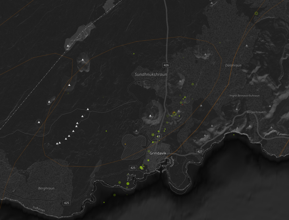
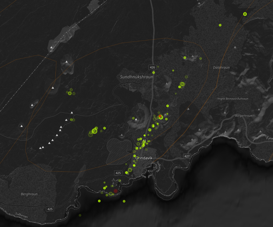
O what a night.. At the last count, there were 252 earthquake of magnitude 3 or more, the largest at M5.2. That is 252 stars on the map, scattered all over the place as the automatic locator cannot cope with this amount of shaking. It is Christmas come early, with 252 stars of Grindavik. The evacuation of Grindavik adds another semblance of that first Christmas story. But so far, it is a lot of noise but no action. The magma has (so far) remained underground.
To recall, this all started with inflation over an area centred roughly on Thorbjorn, ‘child of Thor’. Thor, according to wikipedia, is a “hammer-wielding god associated with lightning, thunder, storms, sacred groves and trees, strength, the protection of humankind, hallowing, and fertility”. We get our name for Thursday from it. There is certainly a lot of thunder and hallowing going on at the moment – but the protection of humankind has been deferred to the lesser gods of the Icelandic authorities. They are rather good at it and overnight they evacuated both Grindavik and the power plant. Work to protect both against future lava flows has been started, by building embankments of several meters high. It worked for the flows two years ago, although in one case only because the lava did not actually reach the wall. The sign ‘lava – no access’ appeared to be sufficient. The risk, of course, is that a wall may deflect lava onto some other property, raising questions of liability. But not knowing where lava will surface makes planning more difficult.
The following map was uncovered by one of our commenters. It shows how far lava needs to travel to get to Grindavik from various locations. At the moment there is no ‘most likely’ location along the rift. The further north, the better, obviously.

It started mid October when inflation took off. A sill formed with an inflow of 5 m3/s. Over three weeks, that amounts to 10 million m3, or 0.01 km3. It added to previous intrusions which had been happening since 2020.
Why a sill? A sill is a horizontal magma layer, which pushes up the layers above it. This is what is causing the earthquakes and the inflation. The earthquakes happened at 5-6 km depth, suggesting the sill was just below this. How does it form? Magma in rock has to find a weakness, a crack where it can insert itself. This can happen at a place where two different layers connect, for instance where the lava pile which has build Reykjanes lies on top of the oceanic crust below. The two are already a bit separate and magma can prise them apart. This happened over an area of up to a few square kilometer: the sill would have been 10-20 meters thick, in my estimation. There is minor magma around than is in the sill: it has a feeder system below although we don’t seem to know where this feeder is.
Yesterday the sill found another weakness. To move up, it has top break rock and that is not easy in such an old, cold lava pile. So it looks for another connection which goes up. This can be a fault, but in this case it found something else: an old fissure system. The fissure sits on top of an ancient dike, and this dike means there is a vertical discontinuity between the rock and the dike. The first earthquakes along the fissure were several days ago, but yesterday it took off. The magma began to build a new dike along the side of the old one.
The magma moved up by 1-2 km but mostly moved sideways. The dikes here run along the direction of the rift, which in Iceland is SSW-NNE. Because of the spreading, it is easier for magma to insert itself in this direction. And now it went fast. As of this morning, the dike extended over 18 km, from a few kilometer off short to far in-land. That does not mean the magma has traveled all this distance. It means that the old fissure dike is breaking away from the surrounding rock.

So where is the magma? The GPS shows an indications. As this morning, Thorbjorn has sunk by 40 cm. This happened because the dike is forcing the rock apart. That the sinking is so much indicates the magma has shallowed. How shallow? My guess is 2 km but it is only a guess. Both Grindavik and Thorbjorn are moving northwest, but that is harder to interpret. Where would an eruption be? Impossible to tell. It can be anywhere along the line. The highest probability is in the original location which is east of the Blue Lagoon. There is a bit of a gap in the earthquakes and that can be a sign – or not. The second probability is indicated by the deflation – that would put the eruption in the harbour of Grindavik!

RUV put out the following (again taken from a comment)
“The signs of magma movement include significant subsidence in the Sundhnúkur craters, indicating that the magma might be shallow below the surface.
The southern end of the crater row is about 1 km from the nearest buildings in Grindavík and approximately 1500 meters from the Svartsengi power plant.
The Icelandic Meteorological Office notes a substantial change in seismic activity, moving south towards the town of Grindavík. According to the Icelandic Meteorological Office, there is a likelihood that magma movement has extended beneath the town of Grindavík.
The volume of magma involved is considerably larger than seen in the major magma intrusions related to the eruptions at Fagradalsfjall.”
Here is the onset of activity, with M2+ magnitudes twice per minute at one point.

An interferogram (thanks Gaz!)

And here is a list of cameras mentioned by our contributors
RUV
Other
View of power plant from Thorbjorn
Live from Iceland has views all over iceland, including:
Albert, 11 Nov 2023
Grindavik update by Carl

Grindavik, photograph taken by VC FB regular Roman Zacharij and used under Wikimedia Commons.
I promised everyone an update today, so here is an update about why I and every other volcanologist should go and drink some tea and ponder why we underestimated a volcanic risk. I will get back to this below.
This will mainly just be an update that I will edit as things unfurl, and I will throw in a little prognosis of what will happen, and where it will happen, based upon the situation at 11.00 Icelandic Time on Saturday.
Short Recap
Roughly two weeks ago Thorbjörn started to show signs of an eruption being possible as a secondary intrusion started, and a sill formed where magma accumulated.
On Sunday evening I felt confident that the prerequisites for an eruption was there based on GPS-data, spectrography over seismic data, earthquake locationing, etcetera.
And based on that data I pointed at a possible location for the eruption to break out, if activity had continued like that I would probably not have been far off, nor would IMO either, we are after all talking about as little as 800 meters between assumed centroids from our individual models.
IMO weighted GPS-data higher than I did, I tend to weight Earthquake-locationing higher. Both methodologies are solidly based on science, and give similar results most often, well similar enough to give an 800-meter difference. Something that in the greater scheme of things is not a lot.

Earthquake map by the Icelandic Met Office. Note that there are loads of “ghost-earthquakes” that never happened, this is caused by over-saturation of the system by signal reflections.
Yesterday at around 12.00 Icelandic time, Iceland decided to kick those models in the proverbial nuts and a dyke started to form that was NNE/SSW trending, putting the most likely location of breakout at Sundhnukagigar, East of Bláa Lonid (Blue Lagoon) and the Svartsengi Powerplant.
This later led to the powerplant evacuating the workers and going into remote controlled operations after some sort of minor accident that was probably caused by strong earthquake activity.
That part of the formative dyke rapidly stalled out, and the bulk of the activity switched down the other dyke leg towards Grindavik.
This forced the evacuation of Grindavik Town itself, a decision that was proven to be a very good idea, but perhaps not for the reason it was based on.
Right now, the dyke is hammering away South of Grindavik in under the sea.
What We Forgot

Let us leave aside the risk for an eruption, and the earthquakes, and even the dyke, and instead look at another side-effect of the earthquakes and the propagating and dilating dyke.
Iceland is truly spectacularly good at moving about, it is extending itself in all sorts of interesting tectonic ways. Faults spread and drift apart, micro-plates dance about and rotate… it is a mess of simultaneous movement.
One of those movements have a scientific name, and that is Graben-formation. It is when due to spreading-movement a lineament of land is dropping down into the void created by the spreading land.
Some Graben like the Eldgjá-Graben form sharp sides, and if you have your house on the exact spot where that side form your house will start to lean, or even fall on its side. But if your house is in the middle of the forming graben you might end up with your house remaining perfectly straight if you are lucky.
This happens in large caldera volcanoes; I saw a house topple over in Amatítlan in Guatemala in a single night from this phenomenon. So, obviously it is well known thing among volcanologists, and something we take into our risk-calculations.
This time though it had an effect that I am pretty certain that nobody had considered, but that we will do in the future when applicable.
Let us phrase it as a question. What happens if a Graben form under a town adjacent to the ocean, and the Graben continues extensionally into said ocean?
Let us begin with numbers as of 11.00 Icelandic time, the Graben has dilated 120cm and the Graben floor has dropped a whopping 96cm (I will edit this as often as I can).
This means that conversely the ocean level has risen permanently 96cm in Grindavik. Obviously, it is not the water level that has risen, it is the town that has dropped.
Grindavik is built so that 96cm is not drowning houses, there is a margin to account for storm surges etcetera, but that margin has shrunk with said 96cm, meaning that storms are more likely to cause flooding along the shoreline and in the port.
Obviously, this is now. If the Graben continue to widen and drop it will get worse.
My favourite Graben in Iceland is Eldgjá, it is 8.5km long, 600 meters wide and 150 meters deep. Obviously the Grindavik-Graben will not become nearly that wide and deep, but a meter or two more depth is obviously not out of the question.
So, there is an idea to look at those Volcanic Hazard Maps and see if another town is at risk of Grabening itself into The Big Fishtank in the Ocean.
Prognosis

Station GRIC 4-hour solution. Image from Sigún Hreinsdottir’s page.
Remember that this is based on data at 11.00 on Saturday, so take into account that conditions could change with time, it is a snapshot of “now”, and based on future trends that are realistic and congruent with previous eruptions of similar nature in Iceland.
I am writing the above paragraph so that even Charles Gregory can understand, hopefully, that a prognosis changes over time and with shifting data. I do though not have great hope of that.
Eruptions are statistical games based on data, and the length of a dyke is indicative of where it will erupt. Thorbjörns dyke has two dyke-legs based on the breakout point (feeder), the shorter leg is the one running East of Bláa Lonid, and the longer leg is running out into the ocean south of Grindavik.
On a purely statistical standpoint it is more likely that a longer dyke-leg will encounter a weakness that the magma can use to pop up to the surface.
What we know so far is that the Northern leg up to now remains dry (uneruptive), but there are faults that way that may in turn end turn up to be the weakest spot along the dyke.
There are also faults and weaknesses on the longer Grindavik leg of the dilating dyke, but they are a bit more spaced out. There is though one thing that is probably going to affect things more than everything else.
It is that the ground level is constantly dropping as the Grindavik dyke-leg extends and dip its Grabening foot into the water. This means that the distance a breakout needs to travel to the surface is decreasing since the overburden become increasingly thin.
Let us assume that the top of the sheet-dyke is 2km deep at the breakout point from the sill near Bláa Lonid, as the dyke goes south in Grindavik the height of the overburden drops around the point it hits the water and it slowly get deeper until it hits the continental shelf, and it drops below the top of the dyke. But the continental shelf margin is quite some ways out.
On top of that the Graben itself is fertile ground for an eruption to pop up, and on Graben margins you often get a formation of a crater row, see Eldgjá and Lakí just as a couple of examples.
In other words, based on current data a breakout is most likely from about a kilometre north of Grindavik down to a couple of kilometres out into the ocean.
As magma rushed into the dyke, overall systemic pressure has dropped, so for the moment the pressure is probably somewhat to low for continued lengthwise progress, and to form an upwards directed conduit, but the last is depending on how firm the overburden is and how much resistance it can put up.

Eldgjá Graben, photograph by Andreas Tille, Wikimedia Commons.
The diminishing systemic pressure is why we are seeing a drop in the amount and strength of the earthquakes (11.00), it is though still quite impressive.
As magma continue to enter the system from the bottom feeder conduit from the mantle pressure will though go up, and we will get increased activity again, and probably the expected breakout. This can happen anytime from a few hours, up to a few days.
But, at this point it is pretty much a sure thing that something will pop up.
Here I would like to make a point, normally the initial breakout is 10-20 percent from the furthest point of dyke propagation, it is not clearly understood why really, it might have to do with some sort of fluid-dynamic hammer-effect, but why and how is not well understood as I said.
If that will turn out to be true here, we will see the eruption start outside of the port. It would be a tad ashy as it breaks the surface and “rooster-tails” form, but as soon as it is above the surface ashfall will rapidly decrease.
In other words, do not expect the end of the world, well perhaps the fishermen of Grindavik have a different opinion, for them it might end up as the end of the world.
I have seen people “biggying up” the upcoming eruption to proportions it just can’t take. No, it will not be even remotely near the size of Holuhraun. That being said, judging from magma-influx and previous eruptions a likely figure would be a peak average discharge rate doubling that of Fagradal eruptions.
If memory serves that was 40 cubic meters per second during the fountaining phase of Fagradal II eruption, so perhaps as high as 80 cubic meters per second during the peak hour, and then slowly falling to 10 to 20 cubic meters per second.
If we assume the length of the eruptive episode to be somewhat equal of Fagradal eruptions, we end up with an eruption at around 0.1km3, and that is not a bad figure as sizes go. In other words, it will most likely be a fairly impressive tourist eruption, but nothing more.
If the influx is steady and continue, we could end up with a longer eruption and the amount of magma would slowly climb upwards. At the extreme end of probability, we get a small shield formation that lasts for up to a century, but that is a very low probability indeed.
As a final thing I would mention that I seriously hope that Grindavik will be affected as little as possible, and that the lives of the inhabitants soon can return to normal.
CARL REHNBERG
P.S. Charles Gregory, “Told you so”. It is now the third time you have been rude and wrong and gotten “I told you so’d”. I suggest pulling in your attitude and stop trying to bully people. I am definitely unbullyable if nothing else.


Even if it’s cloudy, here we can see the Etna paroxism at the moment
Local team live started, better view:
Many thanks, there’s nothing like a good Etna paroxysm.
This is the new armoured zooming 360 camera that will be the main camera for the show.
They bolted it up a couple of hours ago, it is going spiffingly.
What are those structures in the left down corner part? Looks like 4 big goals or frames?
Possibly the remnants of one of Iceland’s less effective poster advertising campaigns.
An exhibition of rock paintings.
I’m not sure but they could be snow fences, to trap snow so it doesn’t heap up on the road when it’s windy.
It is part of the naval antenna array I think, by the looks of it they are ancient and no longer in use.
Thank you.
And the others for the different solutions 😊
From what I read/heard it’s to prevent or “catch” falling rocks.
All should have happened in June, when the daylight is longer … didn’t the EU make some volcano rules for camera friendly seasons?
Actually volcano watching is best done at night. It is self-illuminating. A bit like Grindavik
Live From Iceland has a very similar view (I suspect that this being my 1st comment, you don’t want me to attach a link.) They have a multi-view as well as views from the individual cams. All should be easy to find in YouTube. The individual cams do not allow comments.
Also, I was told the wood things are for New Year’s celebration, but since I’ve no idea what the celebration might look like, I don’t know if I was being joked with.
Kilauea’s SRWZ activity is back by the way. I had given up on the SWRZ with how the summit was inflating fast and nothing was happening to the SW, but it seems it just needed some time to come back.
By activity I mean earthquakes in the connectors and the SDH tiltmeter skyrocketing. 15 microradians up in a little over 2 days, it’s a lot, not as fast as when the SWRZ went up by 1 cm a day in early October but maybe half the rate or somewhat higher.
Thank you for the links!
Here is a very nice tourist map of Reykjanes with texts in both English and Icelandic, explaining the main sites. It’s a high resolution pdf so you can zoom in on the preferred area. Just be patient, can take a moment to load.
https://www.visitreykjanes.is/static/files/pdf/Bordkort/0000_reykjanes-layout_6ju-ni-_a2_si-export_final.pdf
Sorry if someone has already asked this but is anything going on here (steam in the background)?
Source: https://www.livefromiceland.is/webcams/langihryggur
It is the power plant behind Thorbjorn.
You may be right but where is Grindavik?
The left mountain at the horizon is Thorbjörn. Further left would be Grindavik.
As Q says below, Thorbjorn is to the left – I meant Svartsengi. But it is definitely the power plant.
whatever it is it is getting brighter as I was watching
You naile it! It’s starting i think!
Probably not. It could be the power station; they have changed the view on the webcam. But it is brighter tonight than roughly the same time yesterday – weather-related?
It wasn’t there and some linear bright points there are apearing… quakes are rising too…
Hope it’s not erupting there – that is the power station.
But if magma is close to there, could we be seeing more steam as the ground water etc would be hotter?
Forgot to mention, I had a happy 20 mins going through the time lapse for yesterday and today. Got to admire the Northern Lights.
Nothing out of the ordinary happening at the power plant so maybe just stronger winds making the steam more visible on the
Langihriggur cam
Here is cam with geothermal plant.
I now remember how lucky and successful they were that the lava stream didn’t enter Nathagakriki.
There is a kind of swarm happing in the Krisuvik system. Stress release?
Transform faulting probaly caused by strain
Don’t know what the link is. Earthquakes at Krýsuvík occurred at the beginning of this volcano-tectonic episode in 2019 and there has been seismic activity there throughout. When Fagradalsfjall erupted in 2021 and 2022, activity picked up on the drumplots at KRI before those closer to the eruption sites (I did not check in 2023 as distracted by personal matters).
Before the formation of the dike near Grindavík, it was initially thought that this episode was linked to Fagradalsfjall because the swarm started SW of Geldingadalir.
and now a 3.7 quake, first for a while.
Any data on the inflation on Thorbjorn?
The tremors stopped trending down and are beginning to trend up.
I submitted a VC post .. its a nice overview of a volcanic processes
Later I will write more analytical stuff But first a general tour of the subject
I will take a look later today. 🙂
https://www.volcanocafe.org/ios-pillan-patera-eruption-in-1997-the-largest-lava-falls-ever-seen/
Highly recommended you reads my previous Io article as well
How close to the surface is the magma coming to surface? Any increase in surface temperature or steam yet (apart from geothermal sources, that is)?
Do they still need so many lights on in Grindavík while it has been evacuated? They might mask the initial opening of a fissure?
https://www.livefromiceland.is/webcams/fagradalsfjall
I thought the same Merlot. Clearly the Icelanders dont pay such exhorbitant electricity bill as the UK
They have a geothermal power station producing power 24hrs a day with no requirement to import gas or coal there is probably no need to switch the lights off.
I know that really. I am just very jealous. However close to where I live there is a wind farm well out to sea that is producing power enough to power the whole of my county. I still don’t get to see any reduction in my electricity bill, the only thing I see is an eyesore from the clifftop.
Same (although I do like watching wind turbines). I can see an enormous onshore windfarm from my house and yet we have some of the highest charges in UK. I don’t understand why we have to pay for green energy at the same rate as the most expensive oil. It’s so annoying.
It is because in an electric grid you are always shafted by paying for the last MW delivered into the system.
I think you’ve forgotten how intense the radiation is from lava! When the eruption starts, they’ll see it clearly from Reykjavik, just like the first eruption!
This is either going to be anti-climatic or it’s going to occur when I’m in bed fast asleep. Guaranteed.
I was lucky enough to see the start of the last eruption, even though it started behind the hill and all we initially saw was smoke with so many comments it was just a moss fire. less than a minute later it was more than sure the eruption had started as no moss ever fire produced that amount of smoke. So I am also guaranteed to miss the start of the next one.
I was watching when Holuhraun started. This faint first flicker in the dark and within minutes there was the curtain of fire.
And WOW didn’t that one go! I was watching open mouthed as it just seemed to unzip before our eyes. That was amazing and scary all at the same time but so satisfying knowing that no-one would be harmed. The amazing power of the earth unleashed in minutes.
Would have loved to have seen that one live!
It was Ewesome.
Talking of ewes. some lovely sheep rescued today from Grindavik.
I’ve missed the start of all 4 eruptions I’ve watched by less than an hour. The most recent I missed by less than 5 minutes (but since it was possible to watch at 2x speed from the start until live, I can pretend I saw it live …)
p.s. I’ve been trying to obtain a photograph of the first day when it was a line of fissures surrounded by gray that made it look like the river Styx. I want to hang it over my fireplace. The one photographer I found with such a picture hasn’t responded to email or FB messages. I’m happy to take suggestions!
If this thing decides to erupt, it will probably occur the middle of the night. But I could be wrong. It’s currently just after 7 pm in Iceland right now.
I’ve been casting my eye over the earthquake chart by Grindavik, and I find it interesting that the majority of the subterranean activity is once more below 2.5km (for those verified quakes). It strikes me the upper part of the intrusion has cracked its way to the Icelandic Met Office’s 800m, and is sitting there having a rest and a cuppa, while expansion and infill is ongoing at depth.
I assume the fall in general pressure upon the dyke/sill reaching 800m has caused the entire intrusion to ease off for a while while fresh supplies squeeze their way into the lower part.
The upshot being we’ll start seeing the move to a surface breach when the tremors start one more at shallow depths. So, it could be a few days.
Am I right? Or am I just observantly incorrect?!
I honestly think no-one knows just when or even if this eruption will begin.
All the signs are that it wont stop now but never say never.
I think it’s stalled. Just a dyke sill now
The three other Reykjanes eruptions all seemed to stall for days before they started. I think the first seemed to stall for five days and all the scientists thought is was a dud, until it wasn’t. So it’s probably way to soon to write this one off.
I just wish it would erupt tomorrow. Because my heart goes out the the residents of Grindavik who are now displaced and fretting as to how long they must be away from their home comforts. Better to know the worst in my view. Then you can start to rebuild your life when things are more certain.
Also like it is chilled down now that the poor sill has been deflated, but still seems like it is probably growing with the earthquakes and continued growth of the gaben. Saying it is stalled after 2 days is premature, took a couple weeks for the Fagradalsfjall dike to erupt.
I think it just has a solid lid, and probably even more solid if it is below Grindavik with concrete/steel on top. The last 1000 metres will be all solidified lava from millenia ago. I also think it has continued to expand southward and downward rather than up based on the deep-ish quakes.
The rifting has essentially absorbed a large volume of magma which will fill up the dyke, So then it comes down to how much additional inflow and expansion the magma has (assuming it’s too shallow for decompression melt.)
Who needs 3D? Falling dots are far more fun…
https://www.ijsland-enzo.nl/ijsland/actueel_aardbeving.asp
I first came across this site back in 2014. You can relive 24/08/2014 at your leisure (977 quakes).
Thanks! Had forgotten about that site 😊
“A metre-deep sinkhole has formed in Grindavík and this indicates that the magma is very shallow… Unfortunately, it indicates that the eruption will occur within the town limits of Grindavík.” – Volcanologist Þorvaldur Þórðarson.
It was Ewesome.
Talking of ewes. some lovely sheep rescued today from Grindavik.
Sorry this above comment should have gone elsewhere.
but to reply to a320….. OH DEAR! That really is the worst case scenario!
https://www.mbl.is/frettir/innlent/2023/11/12/hafa_uppgotvad_sigdal_i_grindavik/?fbclid=IwAR1GkCOiQAti2BxpXrjkUh3bW8ei-QSEr_FvJVI5VTlUXDUy3HYmStcgESM_aem_Ae9urRBURVquqD9djOaLRi3ypam4SE2MHoOEtXG6QjmqQ6qcIcFicbIuWpLovFh2Wus
Link
Just to clarify he isn’t talking about a particular hole but the regional sinking as seen on GPS. A lot of people in youtube chats think he is referring to an individual hole in the street but he made clear he was talking about GPS readings; “He said that the depression in question and its depth are in accordance with the GPS measurements of the Norwegian Meteorological Agency. This depression would be an indication that the magma tunnel under Grindavík had reached a very shallow level.”
Yes, as I mentioned below, we may not get Surtsey 2.0 but Heimaey 2.0 50 years after the Eldfell eruption.
Yeah, there are cracks sprouting everywhere now in Grindavik according to rescue services and the few locals that was allowed back to pick up animals.
I wish Gylfi Gylferson would fly his infra-red camera drone over Grindavik and take a look.
I think drones are now forbidden within the town limits
yes, I just found out.
A video showing the quakes of the past two days line up.
https://twitter.com/palmargisla/status/1723770864682840516?ref_src=twsrc%5Etfw%7Ctwcamp%5Etweetembed%7Ctwterm%5E1723770864682840516%7Ctwgr%5E370deb24bcf23b61927b9c5cebeb3873a3199e5a%7Ctwcon%5Es1_c10&ref_url=https%3A%2F%2Fwww.mbl.is%2Flivefeed%2Fiframe%2F165%2F
Idaho geology professor shares his view – 5 hrs old – see https://www.youtube.com/watch?v=1Cj1roa856Q
I noticed that the current fissure line lines up perfectly parallel to the previous 3 eruptions, but offset to the west, of course. as Professor Shawn Willsey shares
That is pretty clearly the natural rifting angle on the peninsula.
All lined up again with small quakes along the dike, around 9 pm Iceland time . I guess the flow from the sill has resumed from the sudden release in pressure Nov 10th.
https://twitter.com/volcaholic1/status/1723816703623102645
“We rather expect something to happen in the Eldvorp fissure,” says Ármann Höskuldsson
Isn’t that quite a bit further west than where the dyke is? Is he referring to something else that might happen separately to this potential eruption?
Two hours ago Magnús Tumi Guðmundsson (Professor for geophysics) said that the probability for a marine eruption has decreased significantly. Weaker deformation and seismicity can mean that magma rises slowly.
https://www.ruv.is/frettir/innlent/2023-11-12-obreytt-stada-i-grindavik-en-minni-likur-a-gosi-undir-sjo-396646
Maybe Mama Etna has decided to show Iceland how to do a pretty volcano show. Etna began with Strombolian activity and increased to ash plumes and lava fountains. If Iceland does two eruptions in one year, Etna can’t wait anymore. https://www.volcanodiscovery.com/de/etna/current-activity.html
While the Surtseyan scenario near Grindavik has become more unlikely (as mentioned above), the Heimaeyan type still is possible: An eruption in immediate neighbourhood of Grindavik. This could bury Grindavik with lava and possible phreatomagmatic tephra like Heimaey 1973.
Compared with Heimaey the possible Grindavik eruption may be more fluid. There might come a fast lava flood like Nyiragongo but with less steepness and a bit more viscosity. Warning time would be very short, if this happens.
According to MBL the experts focus on an area NW of Grindavik where there is a concentration of deformation and shifting (if I & Translation program read it correctly):
The school was mentioned as affected by the ‘sink hole’ (graben). That is close to the white dot in Grindavik.
The Grindavik GPS has moved west by 40 centimeters. I assume that this GPS may be on the naval site, west of town. That shift is less than at Thornbjorn which moves 60 centimeters west. Grindavik has also been moving back to the south over the past day while Thorbjorn has not. It seems to me that the centre of the dike shallowing is in between Thorbjorn and Grindavik. Speculation.
A very spot on speculadeduction Albert.
I think the same, and we are in company of Háskolann and IMO on this.
They have the Kvikkugangur running between Thorbjörn and Grindavik.
Which camera covers this area? The two cameras I am aware of seem to be off to one side or the other, just like before when the fissure eruption took off, it was right behind the Litli-Hrutur camera.
Try this one. It pans back and forth to either side of Grindavik. The camera is on Thorbjorn
Albert, thanks for the camera tip, it seems to be one which might catch the eruption. Let’s keep our fingers crossed.
https://twitter.com/volcaholic1/status/1723823162318524621
Magma may have reached a depth of only tens of meters under or near Grindavíkurbær.
Is there a bear in Grindavik?
Or a berry … They have lots of berries in Skandinavia, but few bears.
If there was a bear (like Luis implied) there weren’t any sheeps left to feed on. Today’s social media frenzy was all about the sheeps leavin’ town.
Que?
We have arseloads of bears in Scandinavia (Norway and Sweden).
Iceland is not a part of Scandinavia since it is not situated around the Scandian mountain chain.
It is bær not bear, it is spelled with the letter æ not ea.
It means that it is a place where calves are born.
Ah, that would be a byre in English
(So the magma doesn’t follow “under or near” the bear then.)
Any idea what the surprising Erdvolp call from Ármann Höskuldsson (see above) could mean?
Not a single clue.
Unless he has become a bit “vague up there” I would assume that he means that it is the likely spot for the next eruption after this one, and on that I might agree.
And I would be surprised if Ármann had gotten “vague”. 🙂
What is not gonna happen though is that Eldvórp erupts prior to Thorbjörn.
It simply means a settlement or a farm, it comes from the same etymology as bo in Norwegian (as in “jeg bor i Oslo”). In Old Norse or Proto-Germanic it already means to dwell, to reside.
Too bad it’s not beer.
Recent earthquakes appear to have originated in a two-thousand-year-old series of craters, suggesting that the magma is exploiting a weakness in the crust.
“A bleaker scenario than I imagined” Þorvaldur Þórðarson, a volcanologist who …
I tried google, but it’s clueless right now, do you have the link?
https://twitter.com/DottirGongu/status/1723821398676603063
Some modified plots for you, taken from https://vafri.is/quake:
Unreviewed, above 1M, last 6 hours
Reviewed, above 1M, last 24 hours
I modified the js variable that defines the quake circle radius based on the magnitude. The scaling was too much for my liking and it cluttered the view. If you’re interested, I’ll post the js script and instructions on how to run it (only tested in Chrome on a desktop PC, but should work in Edge/FF/etc. as long as they have a dev tools console). It applies the modified radius modifier even on map refresh (auto or manually), as long as the dev tools console remains open.
Nice, appreciated!
Thanks! That fixes the one thing I dislike about that resource. Much appreciated.
I remember watching the start of the Holuhraun eruption in webcam.
The Grindavik eruption will start soon, I reckon in a couple to a few hours, tonight. As magma moved from 800 meters possibly to something like 50-100 meters, so almost reaching the surface.
It might start in the very first hours of Monday, Nov 13, 2023.
Tomorrow morning we might sadly awake up a city starting to be partly buried under lava.
or not
Looking at webcam I see something to the right of Grindavik. Might just be fog reflecting light…
Will focus on it for a few minutes….
If that is on the camera that pans, then it might be lights from the water treatment plant, or thereabouts.
This camera? https://www.youtube.com/watch?v=PasUycyE96o
Some very shallow small quakes showing up around Grindavik area not on the quake table by IMO
NOW on the quake table. sorry for typo
I wish there was some way to correct your own posts on here!
Alice, I am looking at https://vafri.is/quake/#close and checking, the feed seems about 6 mins late from real time. The shallow quakes are not close to the projected fissure line however, they are some ways away, so I am guessing that they are stress quakes, not ones in the dike.
Ah, thanks for that information Randall. I used to be able to check the quakes on Google Earth using the coordinates given but then they updated google and I can no longer do that for some reason. I am NOT happy with google earth!
A very recent quake mag 2.6 at 5.4 km depth, at 23:19:02 in the ocean SSW of Grindavik would indicate to me that the dike is still under pressure and so magma is still in superposition, part of it expanding the dike propagation and part of it inching to the ground surface.
If you’re viewing unreviewed quakes, the location (and depth) could be off due to automatic ‘guessing’, especially the small ones <1M.
some were 90% which seems to be as good as you can get now the people at IMO have more pressing matters to deal with.
Your comment is true, but I have found that overall the automatic guessing is fairly reliable, and most certainly when it came to tracing quakes along the fissure linement. So I am not going to discount the automatic system as being unreliable. It is giving us fairly accurate information. I cannot wait for AI to improve the earthquake epicenters. I know that the IMO is evaluating these software packages, but it takes a lot of effort to prove out such new software under real life conditions. By now, we all know that the splash of earthquakes displayed on the IMO page is not accurate, but they are doing the best that they can with the available means at their disposal. I salute the IMO for the responsible job that they are doing!
Yeah, and the job of IMO is to be a bit boring and conservative on these things.
You are simply just not “imaginative” when peoples lives rely on you.
So, I bet that any usage of AI would happen only after a couple of years of testing under extremely stressfull conditions (like now), and that they will check how the AI did compared to what they did, and only then decide if it is good enough or not.
Thorbjorn cam is zoomed on something orange
The mbl.is one
https://www.youtube.com/watch?v=P1e_MWJ1nQc
Reflected on the base of the clouds? Reminds me of spotting the start of the 21 eruption…. https://www.youtube.com/watch?v=P1e_MWJ1nQc
Some trivial information while we wait (some of you will know this):
Þorbjörn (Thorbjorn) is an unusual name for a mountain as it is simply a (fairly common) given name for Icelandic men. Sort of like calling a mountain Theodore.
Þ (thorn) is an Icelandic letter which was also used in Old English. It represents “th”. Later when blackletter printers lacked a thorn they would use “Y” to represent “Þ” giving rise to names such as “Ye Old(e) Pub”
Björn means bear so þe name literally means Thor-bear.
The name of the mountain Þorbjörn is also the name of Grindavík’s volunteer emergency service.
Grindavík is pronounced Grin-da-veek.
The town was first settled around 932.
The name is thought to be drawn from grindverk (fence(s)) by the vík (bay). So “Bay of the fences”.
okay, how about Eldvorp? I had a lot of trouble chasing these locations down in Iceland. Can you elucidate on them?
Eldvörp means flamethrower. We might be about to see why pretty soon…
You nailed it while I was writing.
Certainly, although I did have to look this one up in books to get the dates and other numbers right.
Eldvörp is a row of craters (ca. 9,5-10 km long) which produced a lava field of around 20 square kilometers between 1210 and 1240.
This was during a very interesting time in Icelandic history, while many of the sagas were being written. But it was also in the run up to ‘the bad times’. -Preceding a period of civil war which ended in Norwegian dominance over Iceland.
These were violent eruptions but they produced unusually interesting and beautiful craters as well as caves that I have not visited (they are considered dangerous due to the persistent emission of gases).
Eldvörp are in the system which Svartsengi (Power Station) and the Blue Lagoon stand on.
I would translate “Eldvörp” as “Fire Throwers”. In fact, flame throwers (the weapons) translate to Eldvörpur in Icelandic.
I saw a comment that said “björn” is “born”, which is obviously false. As a Swede I feel like we need to respect the old Norse. 🙂
So Torbjörn is a common given name in Sweden too. Someone named Torbjörn might be called “Tobbe”.
As for “born”: the Swedish equivalent would be “född”, which I suppose is a cognate with “feed/fed”. You could also use “börd” as in “of X börd”, which is cognate with “birth”. Not sure about Icelandic/Old Norse here.
As for “björn”, this is precisely “bear” and is cognate too. Imagine an old anglo saxon dude saying Bee-Are-(En) and you’re getting close to the nordic “björn”. Of course in Latin bear is “ursa” so the latin lingos have another entirely different word, like “ourse” in French. The Finns have their own word “Karhu” which has zero connection to “björn”.
Just one more trivial thing, I promise I will shut my cake hole! 🙂
If your first language is English and you are looking to learn another language, seriously consider learning any of Icelandic, Norwegian, Swedish, Dutch or German. There are so many similar words and cognates. The grammar will be different, but the phonetics is mostly easy peasy.
Danish is kind of in it’s own class because it’s really difficult phonetics wise. Written Danish is as easy to learn as written Norwegian or Swedish.
Icelandic has kind of an “archaic” grammar. We used to speak like the Icelanders here in Norway, Denmark and Sweden, but our grammar evolved separately. A common word in Icelandic that you will never find in Swedish is “að”, our grammar is just different.
As for the orthographics of Icelandic, “Þ”/”ð” is simply “th”. “ð” is the voiced variant, as in “they”. We Swedes have none of this natively. This is the reason Swedes may pronounce “that” as “dat” and “thick” as “fick”. Icelanders have it way easier learning to pronounce things in English.
Two more last things: “J” in Nordic languages is always like “y” in English. This is why Nordic learners of English will pronounce “jungle” as “yungle”. The same applies for “ch”. Nordic speaker will pronounce “ch” as “sh”. The English Shannel. 🙂
Yeah, Danish is to the best of my knowledge the only language that has “vomit-sound” as an actual phonem that is used in daily language usage.
Not for the faint of heart to attempt.
I happen to speak fluent Danish and as an Icelander I can confirm, reading and writing the language is easy, but the pronunciation is on a different level. It took me the better of a decade to train my tongue to move that way.
Let us not forget that they also count like no sane people ever would.
You go to the store to buy something and you are told “that will be half-fish vomit-sound”.
I swear that Danish was invented as a way to drive everyone else insane, and that when nobody from another country is around they speak normally. 🙂
(Note: I live just across the bridge from Copenhagen, I love Denmark and go there all the time. I just like to tease them.)
I was lucky to learn to pronounce Danish as a 6 year old child so it came as second nature to me but it it really that strange and difficult? My kids (2l17 & 14) are trying and are getting quite close. With some immersion, I thinks they would ge there.
I also learned to speak Danish at an early age, so I can pronounce the “vomit-sound” on the fly, but learning to count in Danish, no way.
Also, for Carl, as we are in a joking vein, the Danes do have one huge concession that they are willing to cede to the Swedes — the one thing that Swedes have that Danes don’t have. The beautiful view across the Öresund!
All joking aside, one of my (American] family’s favorite things in 1969-70 was to watch a very witty, intelligent game show that was comprised of three teams (Swedish, Norwegian and Danish) with all of the contestants speaking their own native tongues, making nuanced puns that (intentionally but lightheartedly played differently in the three languages). It was revelatory and inspirational to see how these countries could both poke fun at each other and yet embrace their shared past and culture.
Sorry for the off topic post. Remove if inappropriate to the topic at hand.
Well, we did our best to improve their view by building to ginormous nuclear powerplants right on the shore facing Denmark.
But, due to the emergency venting smokestacks they ended up looking like two fists with raised middle-fingers.
The ungreatful buggers for some reason did not like our efforts. 🙂
Once I have a job skill I will move to Iceland, having a nordic citizenship is pure gold if one wants to go for Iceland
Thorbjörn is a bit unusual for being an Icelandic volcano.
Often they are quite a bit more “imaginative”.
Geirvörtur and Úpptyppingar comes to mind.
This is why I love Volcano Cafe. comments teach me so very much. The point about …
Þ (thorn) is an Icelandic letter which was also used in Old English. It represents “th”. Later when blackletter printers lacked a thorn they would use “Y” to represent “Þ” giving rise to names such as “Ye Old(e) Pub”
has taught me something else I didn’t know. Every day almost I learn new things on here. Things my English teacher never knew I am sure. Thanks
right now, 1:33 am, the RUV panning camera seems to have episodes of blacking out.
Randall please dont get all conspiratorial about the cameras again, its out on an arctic mountain adjacent to an active rift that also goes right through the local source of fast wifi, the signal will occasionally die…
I am NOT being conspiratorial, this was just a notice. If the camera is fluctating, should I post to the group or not? What you said never even crossed my mind.
I am curious as to what readers / moderators would say ??
I saw nothing wrong with noting that there can be blackouts. None of the cameras are guaranteed to work full time. Intermittency can be due to loss of connection, either at the camera or the user, or the connected computer being momentarily too busy to keep up with the streaming
It has been glitching since they installed it, and it is also slightly tilted.
Very irritating, but I guess it was a rush job and that the technicians tried to get the hell out of there as fast as possible.
One more thing before I go to bed.
Tried to post this a couple of days ago but I don’t think it went through.
3D quakes (updated every 5 min.):
https://brew.is/quake/
Thank you Danny Boy. I napped earlier so I could stay up with the big kids and watch for first sign. This 3D thing is something I can play with for hours and it doesn’t even require instructions. My family thanks you as well. This will keep me entertained such that I won’t plug in a Strat at 0030 hrs to attempt Watchtower, which is usually loud and fully unrecognizable.
OK, volcano. there’ve been no comments for a while, so I think they’re all asleep! So, you know.. do your thing!
For those who would like to look at current activity in a 24 hour time frame from a Raspberry Shake seismometer, near Vogur, please see https://dataview.raspberryshake.org/#/AM/RBDCF/00/EHZ and the station id info is https://stationview.raspberryshake.org/#/?lat=63.97297&lon=-22.36558&zoom=11.129&sta=RBDCF and you can see the posted quakes too on the map. I think this is pretty cool, it lets you know the current past 24 hour conditions seismically.
p.s. use sensitivity setting 4 or 5 (upper right hand area on panel)
Another info feed that use this raspberryshake chanel …
Supposedly magma is sitting only a few tens of meters deep. Not sure this is so likely thougb, at that depth some heat or fume would start showing, maybe not immediately but soon, its close enough that the magma would be in contact with surface cracks too.
The seismicity is still strong along the whole dike too, its far from over yet.
I have a huge problem too with that assumption for the same reason.
Especially gasses would start to come out at that depth together with steam from the ground.
I wonder if Kilauea 1924 might be a possible model for this current event?
In 1924, Kilauea’s summit lava drained down the SERZ to Puna, where it produced the kind of cracks, land subsidence, etc, we’re seeing in Grindivik, only moreso. What it didn’t do was erupt. The magma stayed underground.
CJ
CJ
Difference is though that the Kilauea’s fissure zone is a permanent magma reservoir in it’s own right, it is able to contain a rather larger quantity of magma without erupting.
Fresh dykes are a bit mor sensitive to things since they are less ductile.
Thanks, I hadn’t thought of the differences in that regard.
I wonder if the supply to the dike has ceased though? To my uninformed eye, the downward trend in seismicity looks pretty steady, so my guess is it’s either pausing or ending. However, by making a prediction like this, I’ll probably be proven wrong by the volcano in short order. 🙂
I would caution against making assumptions about those earthquakes being depth located correctly.
Depth location is much harder to do and require more seismometers than locationing in the two other axis.
Also, to locate something well you preferably have seismometers surrounding the earthquake location, but as soon as you go out into the sea you have the seismometers “behind” the earthquake.
On top of that they are small.
I tend to only bother with earthquakes that are above M2.5 when calculating depths in Reykjanes. The bigger they are, the easier they are to depth locate.
And finally, you need to know the local geology well when calculating depth, for mainland Iceland there is a very good geologic subsurface map giving increased precission, but out in the ocean this is less precise.
I hope this explains why I am not so sure that those earthquakes are correctly located by the automatic system, nor by the technician doing the manual estimates.
Even the best seismologists on the planet (IMO) can’t be better than the accuracy of the input data. 🙂
Completely true, but it does have the side effect of being more likely to note the deeper earthquakes. In a dike, shallower earthquakes tend to (i.e. not always..) be weaker. So focussing only on M2.5 may miss rising magma.
Sorry, Albert and Carl, I chose my words very poorly. By “Downward trend” I meant the amount of siesmicity (Specifically, the seismic energy release), not the depth. As for the depth, I am very dubious regarding the shallowness inferred by IVO (just a few tens of meters) so I’m guessing a kilometre and a half or so for depth at the shallowest. I did see that you (Carl) are skeptical regarding the depth too, though unlike me, you have the knowledge to understand it. I really don’t know enough about the local geology or the dynamics (or, for that matter, geology anywhere) to do more than make guesses based on trends.
My current guess, based on the steady decrease in seismic energy (It’s an accelerating downward curve in net energy release) remains that this event is pretty much over until at least next year. I know I’m being a bit contrarian here, and that just about everyone here knows far more about this than I do, but I’m trying to learn, and one way I learn is by putting my guesses out there, then seeing where I went wrong. Plus, it gives others something to laugh at. 🙂
The 1924 eruption didnt erupt on land, but it is likely an eruption did happen offshore. There was a lava flow found in 1992 that was still hydrothermally active at over 3000 m depth on the Puna ridge. For some reason this has never been brought up anywhere ever since, but HVO has a volcano watch on it… I found the location to be almost 60 km away from where the intrusive activity was first reported under Honua’ula hill, which is the obvious hill that PGV is built adjacent to and where the 2018 webcam of the eruption was sat. So if this was one event, it was one hell of a big intrusion, even most of the bigger intrusions in Iceland are not that big, and nothing since then has been as extnesive, although 2018 was much more voluminous. Some of the bigger Mauna Loa intrusions and eruptions probably do compare though, Mauna Loa is tall enough that it can erupt at -3500 meters and that is still 500 meters above sea level… 🙂 as it did so in 1868.
Should say, this was mostly Hectors hypothesis, and it is not certain to be true. But a dike capable of containing the estimated 0.5 km3 of magma that drained from Kilauea in 1924 would need to be something like 60 km long and 4 km deep if it was 2 meters wide, it seems likely some leaked out somewhere.
Interesting! I’d wondered if it could have gone offshore, but thought it unlikly due to there being no evidence of it. I’d have thought that the sea surface disturbance would be noticed, but if it’s that deep, I can see it being possible that it wouldn’t be.
I think I recall discussing the 1924 eruption with you a couple of years ago – I’ve been mostly offline (I even missed the third eruption of Fagra-unspellable) and now I’m back, I’ve been trying to catch up on the VC articles. ,
You would need a hydroacoustic detection network to detect such an eruption since there would be no evidence of it on the surface.
And in 1924 there was no such network in place, something that would probably have saved Pearl Harbour if something like it would have been in place.
The amount of subsurface eruptions was not well understood back then, it was not until the GIUK-line of hydrophones was put online that we better understood it, and the data was not made available until quite some time later when the GIUK-line was declassified.
It turned out that the MAR is indeed incredibly noisy, and a larger eruption nearby would drown out other signals, like Soviet submarines, so nobody wanted that to be generally known during the cold war era.
Something that is once again true for the new networks being deployed against Russia, but since they are fully digital it is much easier to filter out volcanoes from the pesky submarines.
The Puna Ridge follows the gradient of Kilaueas ERZ still, it is a bit steeper being that it is underwater, but steeper is relative as it still descends at a rate of only 5 km down over a length of almost 80 km. But because of voluminous eruptions down on the lower subaerial rift in the Holocene building up the island there is a hard drop off beyond Cape Kumukahi. The ocean pretty much goes right to 500 meters deep only a few km offshore at the apex of the Puna Ridge, and that is deep enough that it would mask any surtseyan activity although I expect a major vent like the 2018 vent just off the coast would still make itself known. But anything short of that would probably stay pretty passive, let alone eruptions further offshore in deeper water.
It should be said, probably most of that very steep drop is because of the 1960 flow in that particular area. But that flow didnt bury the Cape itself, and a steep drop still exists there regardless, so it was still present there anyway.
A pillow lava eruption deep below the surface would have happened completely unnoticed. That’s in fact an effusive gentle submarine eruption, while a Surtseyan eruption is explosive.
Oki, I think I will go and poke Thorbjörn with a stick until something happens…
Morning all!
Morning.
Unchecked quakes of today so far (upside down obviously, with larger depth above). Note that depth seem to increase the further offshore the quakes occur.
Since ChatGPT knows Icelandic it’s a pretty good site to use to translate local news articles and observations to English. Not perfect but it does a very good job in my opinion.
We’ve probably all seen the photos from Grindavík taken by the road authority folk checking out the damage there, as well as images captured at the golf course and other locations in town. Does anyone know whether similar damage surveys have been conducted at Svartsengi and the Blue Lagoon – and if so, are there any reports or information available online?
It has been done by the plant staff and the authorities.
The damage has been less dramatic.
But, being a company they feel that giving out any data or images would be to give out their precious “business secrets”, they are treating it as confidential information.
I am actually a tad miffed at the company owning the plant.
They have also flat out refused to give out water chemistry data, and the changes that have occured to said data during the intrusive episode.
That has hampered detection of what is happening, and put the plant into danger as such.
Obviously that is not conforming to best safety practices standards, since sharing such data with other Utility Companies is the norm for operations safety reasons in case a volcano is about to erupt below your arse.
The company in Hawaii freely shared similar data with other geothermal power companies and consults, during the eruption.
They also took in an independent consultant to verify their data and findings, and to give pointers about how to manage the situation.
I liked that.
Disclosure: I work for a geothermal power company and have a vested interest in geothermal powerplant operations.
Thanks, Carl. That *is* frustrating.
I assume the Blue Lagoon has been examined as well – though perhaps not as urgently, as it’s in shutdown – have you heard anything about damage there?
Isn’t the damage in Grindavik and surroundings caused by the forming of the graben? Svertsengi and the lagoon is not affected by that graben.
If I’m reading this correctly ( ) GPS station SKSH – which is quite close to the lagoon and the power plant – shows about a 44 cm drop in elevation and significant lateral movement as well. Not as dramatic as the town, but not nothing, either.
Yes, SKSH dropped a lot, but it’s also on top of where the source of the magma that went into the dyke is located, so it’s probably more of a deflation signal than that of a graben formation.
Almost all of the Reykjanes GPS stations are showing very extreme offsets:
http://brunnur.vedur.is/gps/reykjanes.html
Does anybody know what’s going on? These numbers can’t be right.
Tomas, I completely agree. I just am curious about the damage nearby.
Hildur, those signals are all correct.
Iceland is just feeling like it want to do some serious landscaping. 🙂
The signals was far worse during Holuhraun by the way, it just didn’t completely show up like this due to the distance to the instruments was far larger.
I also wonder what is happening to the CO2 storage project that is also at Svartsengi, if I’m not mistaken. Stuff deeper layers with gas…find it hard to imagine that it would solve the CO2 matter, or even worse, may it even be a factor that can cause instability?
Far be it for me to have opinions about other companies and what they do, and I do know one of the major owners of that CO2-plant.
Ah heck… time for another: Told you so.
Pumping CO2 into a fracture is just asking for problems later on, because that CO2 is bound to come shooting up.
If you want to pump CO2 it is better done under a solid section of plate that can work as a cap during the time that the ground chemistry is at work transforming the CO2 into Carbonatite.
We are looking into it at one of our sites, and looking into using CO2 as medium in artificially enhanced geothermal systems in another spot. But, neither of those are inside a volcanic system fraught with fissures and rifts.
I hope they share any changes in the geochemistry with local scientists.
One would hope so.
But, it is a tad worrying that neither the University, nor IMO, has referenced such data.
After all it would be a good source to understand what is going on underground.
New sentinel image this morning of Iwo Jima. Completely clouded out. However, I think a heat signal would still have come through and there wasn’t one, so my guess is that that eruption has ended.
Sniffle, it was a cute one.
I love my little island-formations.
What are these four support structs you can see on the Fragadalsfjall camera you ask?
I just realized what they are! 🙂
There is a path just behind them.
So if you walk past them with these structs to your left, you would read in digital clock letters:
2023
That must be it! 🙂
Last 24 hours
Here is a map I made of the area, showing the existing Sundhnjukar fissures in red as well as roughly where the new dike is in blue.
It looks like this dike is a little more towards the south than the one that would have made the original fissure. But it is also possible that the Sundhnjukar fissures are not all from a single eruption and that the rift was expanded upon over several events over perhaps years. In which case really all bets are off what happens next…
One things is unfortunately clear and that unless this majorly deviates from the standard of this area Grindavik is not in a good place, but I dont think my picture was necessary to see that…:(
I‘m certainly not an expert but the closeness of these two lines may also indicate uncertainty about the measurements? And of course the fissure where the magma currently is is also several hundred meters below the surface and thus does not have to align with the structures we see on the surface, nor does the fissure necessarily go perfectly straight up.
And in the 2000 (?) years since the last eruption continental drift – depending on how and where to that part of Iceland is drifting (apart) – may also be a factor.
IMO those two lines are „close enough“ to be identical from a geological perspective. 😉
Latest
Earthquakes at Grindavík again occurred at a depth of 4-6 km. It may mean that the magma will not reach the surface at this time
https://twitter.com/Icevolcanx/status/1724023382226682306
Looks like the volcanologists in Iceland are carefully preparing the public that the volcano might not erupt. I’m not really sure if this is good news, though. If the deep feeder is still intact (and this is very likely), magma will continue to flow and pressure will increase over time.
According to IMO and Icelandic authorities it was always an option that the magma doesn’t erupt. The latest IMO statement simply says that there are no changes since yesterday, so no eruption is the second most likely scenario (ground eruption being most likely and underwater eruption being least likely).
I may be an absolute layman compared to the volcanologists, but I think this “no eruption” talk is premature. After the rapid expansion of the dike on Friday/Saturday, it’s logical that the pressure in the system dropped, meaning smaller and fewer earthquakes. Unless the earthquakes fully stop I expect the pressure to build again in the coming days until there is an eruption.
Ding!
This is exactly what happened.
We are now starting to see renewed signs of increasing pressure in the system.
It was the same prior to all 3 Fagras by the way. “lull”-periods in between quake-swarms, and then all of sudden “peekaboo”.
It will be the same now.
The fall in Svartsengi.. could this partly be explained by existing rock being molten by the sill top and bottom? So more lava goes out than came in? Probably a silly thought.
Over such a short span in time the effect would be fairly small, but it could indeed be a small contributing factor.
Perhaps the final push before it begins…
Kilauea is getting pretty restless again, now both of the upper rift connectors are active together, and quakes go way down the SWRZ. HVO actually changed their update wording today to say that “no unusual activity has been observed on the ERZ”, meaning the activity on the SWRZ is getting their attention now.
At least if this one goes no one lives above the dike this time.
I think that any surprise shouldn’t surprise us now. It’s both possible that nothing happens soon at SWRZ and that a fissure of fires opens suddenly.
Even if it were not to erupt with such a shallow dike beneath grindavik, could the town still be affcted by gas emissions, like La Palma’s Puerto Naos?
Not nice if basements are full of co2 from the degassing magma
They are most likely filled to the brim with SO2, CO and CO2 and other nasty volatiles percolating out of the ground. I would not go down in a basement there.
Makes me wonder, do most houses in Grindavik have a basement? Walking around residential streets virtually on street view, most houses look to my eye like they are built on slabs on grade, although a few of the older buildings do seem to have basements.
A good question, I honestly never wondered about it when I was there.
Perhaps one of our happy Icelandic fellows could help out and answer this?
I looked at the plans for a few random single family houses and none of those have basements. Some multifamily buildings and commercial buildings do have basements.
Thank you.
I hope everyone was told to not go down into the basements since that would be the sport where volcanic gases would pool.
Thank you very much for checking!
Might still be dangerous for pets or childen if there is ot of CO2 in some areas. Hope an El Paso situation can be avoided, even if the area was unaffected by the eruption 2 years since and people cannot return, and it seems we are in for a long lasting issue there…
Has the sea already progressed on the graben area of the coast anywhere? Do they have to build a dutch dyke to avoid the impact by the volcanic dyke?
IMO
Activity almost unchanged from yesterday
Deformation from the intrusive dike is measured most at Sundhnúki
Updated November 13 at 11:40 a.m
Seismic activity in the intrusion zone has been stable since November 11. About 900 earthquakes have been recorded since midnight today November 13. The seismic activity is spread around the southern part of the dike between Sundhnúk and Grindavík at a depth of about 2-5 km.
A slowly decreasing deformation is still measured at Grindavík. Deformation from the intrusive dike is greatest in the middle of the dike at Sundhnúk, where the main upwelling area of magma is believed to be.
It is the assessment of IMO that the activity in and around Grindavík is almost unchanged since yesterday. All measuring systems are carefully monitored in real time, especially at Grindavík
https://twitter.com/xingjun_luo/status/1724005127097323989
The latest Sentinel-1 interferogram has a wide range and large magnitude of deformation. The deformation in the decoherence area may be over 1 meter.#Iceland #Grindavik
Nice one! Here we clearly see how the deflation of the sill is superimposed on the butterfly pattern of the dyke. The left “wing”, which is motion towards the satellite, is interrupted by an area with motion away from the satellite, that happens to coincide with the area where the sill uplift was previously observed.
Our theory that the odd horizontal movements in the graben portion near Grindavik were due to sill deflation seems to be correct.
Can the sill produce future eruptions even if the current intrusion fails? The last eruption period lasted 1210-1240. Do we see currently how the magmatic base for such a period is being built?
Image from tweet
Just curious. I can see the large “butterfly” and the location of the dike, but what do the two smaller “bulls eyes” or circular features near the coast to the west of Grindavik indicate?
The southernmost small bullseye is actually part of the left wing, but the middle bullseye that represents the deflating sill has reversed the order of the fringes in that area. Take that one away and the bottom one would also disappear to become part of the big wing.
Another interesting observation is that in this image the satellite is in an ascending orbit, facing east, but in the image from Nov 10 the satellite was in a descending orbit, facing west. This means that in the Nov 10 picture, the sill deflation and left butterfly wing of the dyke deformation were both away from the satellite, so the deflation is not visible in that picture (partly also because the fringes were too dense to show up with the available resolution).
Thanks for your response. I have a layman’s understanding of interferograms but your detailed explanation is appreciated.
Speaking about languages, my native language is dutch but the nordic languages intruige me. I just don’t know how to start learning them. I feel like i need a “use” for them to encourage learning it, and it’s more curiosity instead of practical use. English is easy for that reason, since it has a lot of resources available and it’s like necessary to navigate on the internet or for all of my hobbies. It’s basically the lingua franca of today.
I’ve heard about Danish prononciation being hard, Icelandic sounds fascinating but the resources to learn it might be scarse. There’s also Faroese which is closer to Icelandic and Old Norse. Norwegian also has a difficult situation in that the geography means the language can differ a lot based on where you go and there being Nynorsk and Bökmal (i don’t know the difference between the two). I suppose Swedish might be the most accessible and probably the easiest to learn, ignoring resources.
Dutch (my language) is basically historically western German or a dialect of German that evolved separately, while German today sounds distinct because the standard language is basically the bavarian / high – south german dialect, while dutch was influenced mostly by holland and brabantian dialects. (antwerp refugees after the 80 years war that resulted in the Netherlands being independent). It’s why my local language sounds very different from dutch while this is less the case for people living in the ancestral areas of brabant & holland. Frisian is also more distinct again. A part of where my language was also spoken (the flemish area) also got french since than, so it’s basically just the area of west flanders, parts of east flanders and the dutch province of zealand now.
It’s a bit of an error to see everything as 1 language: dutch and german. It’s the standardization that gave them their structure, but it’s more of a dialect continuüm and if you speak of separate languages, there are more, it’s just that over time and with the need of economical matters and invention of television and schools, there’s only one accepted variant.
My local language for instead is due to Bruges being an important trade city with English for long time, and the more close location with the french linguistical border dutch with more english and french influences, while dutch itself is basically german that is closer to english. Old dutch did have the grammatical cases (of german), you still hear them in “old sayings”, but over time the language got simplified and the cases are no longer in use really. Sentence structure is closer to german but not exactly the same.
You are correct, Swedish is nowadays the most uniform of the Nordic languages.
But, that is a quite modern thing.
Already back when I was a kid there was larger regional differences, especially between the North and the South.
If I really want I can still speak the northern dialect I grew up with and nobody in the rest of Sweden would grasp what I was talking about.
But, as mentioned, nowadays nobody use those dialects, and they are rapidly dissappearing and National Swedish is used throughout.
Finnish is one of the strangest languages I ever came across!
I didn’t even begin to learn it. I once learned a little Swedish when we visited for a holiday but have forgotten amost all of it. The only phrases I remember are I am hungry and I am thirsty. I am nothing else but a practical person.
Food is almost always the first thing you learn to say in almost all languages, at least for me it is.
We are after all sort of programmed to care a lot about food and drinks 🙂
Indeed. Food and water are the most important things only topped by air to breath.
I was young and not so considerate in those days so I cannot remember Swedish for please but do remember thank you.
Please would be snälla, but we never use that.
Instead we just append “tack” to the end of the sentence instead.
In English it would be:
Please, could I have some meatballs?
Swedish version:
Meatballs tack!
More efficient, and not considered rude (in Swedish).
Is Swedish tack the same word as thanks? Because the way you used it sounds exactly as such. And likewise saying ‘meatballs thanks’ in that context is not rude usually.
🙂
Tack = Thanks
Tack detsamma = The same to you
The latter is used for everything from Christmas to F… off.
Merry Christmas! – Tack detsamma!
F… off! – Tack detsamma!
It is the tennis racket of conversations in the Swedish language.
Swedes are people of few words
Finnish? You are mistaken! It’s French that is the oddball amongst the European languages. Try to write it phonetically, and you will see.
As for Scandinavian languages, I would suggest learning Icelandic, because it has much more character than the rest (except maybe Faeroese). It’s essentially the old Viking language, at least in its written form. And there are also much more volcanic activity in Iceland than in the rest.
French is unpronounceable for me. Since a very small child I have never been able to pronounce the r sound in French or even the rr in Spanish. So I gave up and never learned another language, as I am sure there are so many pitfalls in pronouncing any other language. I have noticed that manyr of the Slavic nations tend to say ‘The’ as ‘zee’ or ‘they’ as ‘zey’ so I am sure othe nations can find some English words difficult to pronounce too.
Finish is a really “new” language where you really have to start with zero knowledge if your mother language is different. Unlike this if an English person learns French, there is still much in common. But Finish still shares the latin letters which is an advantage compared to Chinese or Arabic.
Nope, the true oddball is Euskadi, more commonly refered to as Basque.
It is the only paleo-language in Europe and it is not related to any other language.
The least useful book is the Basque – Etrurian Lexicon, printed in 100 copies, and I am the proud owner of one of them.
I can safely attest to it being incredibly useless since nobody will ever translate anything from Basque to Etrurian since there’s no Etruscans galumphing about.
It is though a book I treasure a lot.
French is easy as they only answer in French. The Finnish speak English. French is easy because they force you to learn it. And they don’t really like the English, just their money. Savills and Knight Frank in every slightly attractive village.
As for “use”, I get that. I will just learn something because I’m a learner and because the experience of learning in itself is rewarding to me. That said, I’m an auto-didact so I don’t exactly approach learning optimally. I’ve been “learning” French for two decades and I can sometimes read a Wikipedia article in French and understand much of the material, but I couldn’t tell you, in French, that I’m currently sitting in my sofa listening to a podcast with my cat. Let’s just say there would be lots of hand waving and “pödkäst”, “chat” and “alors” and what not. 😀
As an inept speaker of German (Ach Mann!), I’d love to learn Dutch. What if we could swap brains for a couple of months and learn each other’s languages. 😀
Dutch is as unlearnable as Scandinavian languages because they all answer in English. Most Dutch and Scandinavians speak fluent English, congrats! You learn languages by talking.
The easiest language to learn is therefore French as most French abhor speaking English.
The Germanic languages are relatively easy to access from one to the other. There is a bit larger historical cleavage between the “west germanic” languages (English, Dutch, Frisian, Low German and High German) and the “nordic germanic” languages (Icelandic, Faroese, Norwegian, Swedish, Danish). But the Hanseatic trade also moved Lower German words into Danish, Swedish and Norwegian, so that Dutch and German people now have it very easy to learn the three languages. Icelandic and Faroese stayed more purely “Nordic Germanic” and are therefore more difficult.
English itself moved over time away from the other west german languages. It integrated many roman and french words. Otherwise it would remind much more to Lower Saxon or Dutch. In fact it has become a semi-german and semi-roman language…
English today is basically a combination of every language at this point. It was originally Germanic as you saud, but it is probably better to call it a combined Germanic and Romance language. Personally, written French and Spanish make more sense to me than trying to read any of the Germanic languages, but spoken sounds like nothing intelligible without a subtitle to follow.
I was quite confused by Dutch, it took me rather longer than I would like to admit to realise they werent speaking English, even though nothing said actually made any sense 🙂
Modern English also has a lot of acronyms that have been turned into real words, which might be a unique thing really, although im sure there are others. It also has quite a bit of Japanese words in it too now if you spend any time on certain parts of the internet… 🙂
Frisian is supposedly the closest germanic language to English. Aspects of it are much closer to English than is Dutch.
I do wonder about the ‘bjorn’. I interpreted it in Thorbjorn as originally coming from Thor born – Thor’s child, rather than Thor’s bear, as it seemed to make more sense. That may well have been wrong – but only polar bear exists there and these are quite uncommon in Iceland, and not obviously related to Thor! Anyway, always happy to be shown wrong!
I forgot about the Danelag … there was a time when England was colonized by Vikings, and they left some words for the Englishmen. But it was a small influence, smaller then the current influence of Anglo-American culture.
Some English words are in Dutch and Lower German written similar, but orally different. F.e. “water” is the same word, but in Lower German they speak it like German “a”. Also the word “house” is usually more spoken like o-u than a-u.
Dialects apart, I found Norwegian (bokmal) very easy to learn, even easier than other languages that are closer from my primary languages. The simplicity of the grammar is probably why.
For Germans it’s most easy to learn. Either the Norwegian grammar is easy or it’s like in German (when things get complicated).
The magma has gone down to a bigger chamber underneath. So no eruption now.
The volcano discovery app told me..
There are few things with less credibility in my eyes than that app.
In the real world we are sitting following the pressure and magma slowly move upwards.
Now it’s becoming dangerous that they let the people back to Grindavik. Maybe they should wear fire safe costumes …
Today Eldeyjardrangur got some Magnitude 3 earthquakes. The Wikipedia list of historical eruptions (I hope it’s reliable) tells that during the onset of the Reykjanes Fires 1210 also Eldey did an eruption 1210-1211. Is a volcanic concert possible with various eruptions in the whole larger area? If we look at the intrusions and eruptions since 2020, it already appears like this. After some years Fagradalsfjall may look like the “Appetizer” for the major Fires. Fagradalsfjall did a good job to catch global attention for RVZ.
After the Intel debacle with the SRT divisor routine in the Pentium chip, as Dr Nicely found out, our automatic reliance upon “app” and other software needs to be taken with a grain of salt. I worked in aerospace, we’ve even gotten it wrong there a few times (leading to loss of aircraft) so even the newer software apps need a time of evaluation. Today too much is just shoved out the door.
Mystery solved. 🙂
I hope the image appears inline.