Six months of episodic earthquakes and ground swelling along the Southwest Rift Zone of Kilauea have finally culminated in a major event. As I write, the volcano rifts. We have a dike. A blade of magma cuts its way across the rift zone generating earthquakes outside of the SWRZ connector, the usual area of seismic activity. The NW rim of Kilauea caldera deflates at dazzling speed. The UWE tiltmeter that most faithfully records the state of Kilauea’s summit magma chamber has plummeted by 35 microradians and is still falling, which is as much as it dropped during the past year’s September eruption. This means a comparable amount of magma has intruded the Southwest Rift Zone in about a day, as was erupted in about five days during the September summit eruption, making it a major event already, regardless of whether it erupts or not.
How we got here
We’ve been following the SWRZ situation in the comment section for months. I also published two articles about it, which are the following:
I will review the situation. On August 14, 2023, following a surge in Kilauea summit inflation and two small summit intrusions, the uppermost SWRZ (Southwest Rift Zone) experienced a substantial episode of seismic activity that gradually propagated downrift and was followed by inflation. This unrest was continuous until the September eruption of Kilauea. After this eruption, the summit entered a recovery period in which the SWRZ was not active. The SWRZ resumed activity with a sudden seismic crisis on October 5. There was spectacular inflation of an enormous area to the southwest of the summit, reaching 1 cm of uplift per day at its center. Activity decayed somewhat after some days, but intermittent episodes of activity lasted until December 15. On December 30 another episode of earthquakes and inflation along the SWRZ took place that lasted just a few days, and from there it was calm until January 27, when a new episode started which has evolved into the current dike intrusion. All of these events generated earthquakes along the same area, which is known as the SWRZ connector, a line of seismic activity that extends downrift from the south rim of the summit caldera. The connector is usually regarded as some sort of horizontal magma conduit that makes up the core of the rift zone. I think it’s more than that though, I believe it represents the upper edge of a complex of deep dike intrusions under the rift zones of Kilauea. This would be the structure referred to in many articles as the deep rift, usually regarded as a vertical dunitic mush body that drives seaward spreading of Kilauea, but its behavior I think is showing to be more fitting of a series of “perpetual” dikes. As these deep dikes expand, what I suspect happens is that the flank gets pushed southward and also the ground above is torn apart making earthquakes along the connector. Rising pressure in the deep rift pushes magma upwards into horizontal sills, producing elliptical areas of ground inflation. That is what I believe the unrest episodes over the past 6 months were.

Map showing SWRZ earthquake activity between August 13 and November 26, 2023. The earthquake locations are from the openly available USGS catalog and highlight the branch of seismic activity known as the SWRZ connector.
The dike
We were having another connector seismic crisis. This one was intense in terms of seismic activity and inflation rates. Things changed yesterday. Towards 4 HST (Hawaiian Standard Time), there was a dramatic increase in seismicity, there were so many earthquakes per minute that they merged into each other. The ground was non-stop shaking in the seismograms of HVO. It appears around this time some magma-filled cracks may have started propagating into the surrounding rock, generating a very intense seismicity. We were following the situation in the comment section yesterday as it escalated. Around 5:30 HST the earthquakes started to hit outside the connector, to the west, and about the same time, the UWE tiltmeter started dropping, revealing that magma was exiting the summit reservoir and Halema’uma’u subsiding as branches of magma spread beyond the SWRZ connector to the southwest. Around 6 HST a cluster of large-amplitude earthquakes occurred in the SWRZ for several minutes coincident with a very fast drop of 1 microradian in the UWE station, at that time it was when I noticed that a dike was forming. IKI and UWE were showing rapid deflation of Halema’uma’u and SDH had also gone crazy with its components showing extremely fast tilting that was probably coming from rapid inflation in the South Caldera area. I went to sleep after another cluster of earthquakes had shown up spreading beyond the connector to the NE, towards Keanakakoi Crater. The intrusion seemed paused, and I thought might be over, but it was not and kept throwing more growth spurts. Now the UWE tiltmeter is down by more than 35 microradians and earthquakes cluster into a nice line, some 6 km long, the trace of a dike intrusion. The distribution of earthquakes is the following:

The orange circles are earthquakes located by HVO today. Blue areas are those active during episodes of connector seismicity. Red lines are possible dike segments that have been intruded.
The map above shows that earthquakes (orange circles) are happening outside the connector (light blue areas) in multiple places. Where they overlap the connector just south of the caldera I think is the starting location of the dike intrusion, given that earthquakes were initially clustered there before exiting to the SW and NE. The distribution may require two separate parallel dikes. It’s not uncommon for this to happen, and the Upper East Rift Zone of Kilauea is known for double dike intrusions where magma makes two parallel but separate dikes, the last time was the 2007 Father’s Day intrusion. The reason could be that these intrusions involve a mix of sill and dike intrusions, horizontal sills turn into vertical dikes so that the whole thing is one intrusion but with multiple interconnected sheets of magma, both vertical and horizontal. In the following map, I compare this event to earlier dike intrusions of the SWRZ, the 1963 dike trajectory is not well recorded so it’s not in it:

Map of the three major, well-recorded, dike intrusions that have taken place since 1970. The seismicity of the SWRZ connector is also shown as blue areas, and the volcanic cones of the Kamakaia Hills as green triangles.
The larger segment would be following a trajectory similar to the 1974 and 1981 dike intrusions. It roughly follows the middle strand of the SWRZ. The smaller segment may be following the southern strand of the SWRZ that last was active around 1800-1810 with an eruption of the Kamakaia Hills.
Will it erupt?
It’s always hard to know the answer to this. The middle strand segment could perhaps erupt in the area of the Puu Koae and Cone Crater cones, but this location is higher than the summit caldera floor right now, so I’m not sure pressure will suffice. The southern strand segment is right now in a non-eruptive area that is too elevated where dikes always fail to erupt, but should it grow downrift it could reach the Kamakaia Hills and erupt there. There is a factor to consider, and it’s the amount of evolved magma that may exist in the area. many eruptions here seem to produce slightly evolved lavas. For example, the last Kamakaia eruption, Kamakaia Waena around 1800-1810, started with basaltic andesite lavas and ended with evolved basalts. This eruption was long-lasting, possibly weeks or months, and emitted some 0.1 km3 of lava. Other earlier Kamakaia Hills eruptions are similar. Prehistoric eruptions of the middle strand, like Puu Koae or Cone Crater have also erupted sluggish lavas and made cones of a strombolianish appearance so while I’m not aware of the composition I suspect they might be slightly evolved basalts. How much evolved magma exists in the area could be a key factor. It’s also important to consider that the major dike intrusions in 1963 and 1981 that rifted the middle strand of the SWRZ did not erupt, and right now Kilauea is in a lower pressure state than it was then. I think that the best chance for an eruption is for the intrusion to follow the southern strand of the SWRZ down to the Kamakaia Hills which are well below the summit caldera floor in elevation and may contain large amounts of evolved magma formed in the past 200 years of dormancy of the volcanic cluster. So as it always happens with volcanoes, they are full of surprises and it’s hard to know what they will do next. It’s also important to note that the area is completely uninhabited, so there’s practically no risk of damage taking place.
Tiltmeters update.
I’m adding a bit about tiltmeters to the article after publishing, to explain a few things. Recently the subject of tiltmeters has shown up during discussions in the comment section. Tiltmeters are instruments used to measure deformation at the Kilauea volcano. You don’t see many explanations of how these instruments work or how their data can be interpreted, so I will explain a few things and show the current event as an example.
Tiltmeters measure changes in the slope of the ground. The unit given is in microradians which is one millionth of a radian, the standard unit for measuring angles. As Albert noted in the comment section of the previous article, a microradian is the equivalent of a change in altitude of 1 mm over 1 km of distance. They are highly dependent on direction, for example, the ground might rise exactly to the north, and this will change the tilt in a N-S direction, but not in an E-W direction which remains unaffected. That’s why HVO reports the tilt as two directions perpendicular to each other, to give a full sense of how the ground is deforming. The direction is given as a number in the top left corner of the graph, and it is an angle in degrees from the north and in a clockwise direction. For example, 90 would be tilt in an east direction. The tilt value itself refers to the angle from the vertical, if the tilt is going up it means the ground is sinking relative to the station in that direction. HVO uses radial tilt. For example, UWE in the NW caldera rim is given in a 327 direction, which is roughly NNW direction, and this direction is radial to Halema’uma’u, it points away from Halema’uma’u, the central magma chamber of Kilauea. When the tilt goes up it means the angle from the vertical in the radial direction of Halema’uma’u is increasing, this happens when the station is rising relative to the ground to the NNW of it because Halema’uma’u is inflating. Up means inflation and down deflation when the tilt is radial to (points away from) the deformation source, here being Halema’uma’u:

UWE data which is tilt radial to Halema’uma’u
Let’s look now at what the other stations are doing. At IKI the blue component is going down and the green not doing much. That means the greatest tilting is happening in that direction. The blue component is 62.5 degrees from the north, about ENE. This seems radial to Halema’uma’u. So down means Halema’uma’u is deflating, the same as UWE.

Then we have SDH, fundamental in monitoring situations just south of the caldera. It gives two components that are going down at similar rates. These components are almost exactly NW, and SW. The maximum tilting must be in between them, or about W. It’s going down. Is W radial to any source? It is roughly radial to the south caldera area, which comprises two nearby deformation centers roughly located near the OUTL GPS and KKO seismometer both to the east of the SDH tiltmeter. This means the south caldera area is deflating because its radial tilt is decreasing; the angle from the vertical decreasing. I should note that originally the blue tilt seems meant as a component radial to Halema’uma’u, and the green component radial to one of the South Caldera sources, the one near OUTL which is related to the SWRZ connector. But because here the deformation is wide and probably spans all summit sources the deformation is coming from the south caldera area that might be a bit central to all.

Lastly, there’s ESC. There are two components. A 0 component (north), is rising. A 90 component (east) is decreasing. At relatively similar but opposite rates. What does this mean? In between them, NE-SW, there must not be any change. The maximum tilting is in the NW-SE direction. It happens that ESC is to the SE of the South Caldera source, so that SE would be the radial tilt to it. This is not given in the graph but, from the two components given, it can known that SE would be down like in the E component but more, being the direction of maximum tilting. ESC like SDH reflects deflation of the south caldera region.

The south caldera area comprises sills that are related to the SWRZ connector and the UERZ (Upper East Rift Zone) connector, twin nearby sources at the start of both rift zones which together are very important areas of magma storage. Very primitive magmas that evolve under the SWRZ and the UERZ (Upper East Rift Zone), probably end up as basalt in the sills of the South Caldera area. This deflation is to supply the dike that right now advances down the SWRZ.
HVO Kilauea page:


With this level of activity, would they be able to detect magma movement in time? Building activity could mask small quakes.
Source for image: https://www.livefromiceland.is/webcams/fagradalsfjall
It will be pretty obvious over background noise when a dike starts opening. Not like we’ve really predicted when it will go before then anyway except in the broad sense of “this is when the sill will have reinflated to last time’s level” and that is perhaps a bit too reactive, since sill seems to be reaching a bit higher before leaking each time.
Like people are jumpy, but it will be very clear when it is starting to break and *very* obvious when it erupts. Issue of course is the hour’s notice and the possibility of opening in the town itself.
I am wondering about their evacuation protocol too, as there are lots of obstacles to getting away from the likely eruption area quickly, particularly in those bulky machines
I use to wonder about them moving those machines fast also. However since seeing the men racing to rescue them from right in front of the flowing lava of the last eruption and seeing the speed they fired up those machines and raced away I no longer worry. Also they have plenty ofspace to the east to move them out of immediate danger.
In their Update IMO wrote yesterday: ” there is an increased likelihood of a new magmatic dyke intrusion and ensuing volcanic eruption in the coming days to weeks.”
We just have to wait for the next intrusion and likely quickly get an eruption. The vertical distance is short between the sill and the surface.
There is a seismic gap between the north east and the southwest of Grindavik as far as the Grindavikurbaer peninsula. This is I think the next likely place to erupt. It trends southwest across Grindavik itself.
Apparently the supply rate to the sills under Svartsengi is about 5 m3/s between now and the last eruption. Which would make it about as productive as all of the rest of Iceland combined with a bit extra 🙂
It is though not actually higher than Kilauea, which I found a while back might be as high as 8 m3/s right now and since about a year ago, although Svartsengi is higher than Kilaueas long term average.
Actually based on the amount of deflation at Kilauea, a drop of 1 microradian on the UWEV tiltmeter seems to be about 1 million m3, maybe a bit less. So the 7 microradians up at UWEV would be about 20 m3/s supply to Halemaumau. Although there is still a deflationary tilt at SDH, which would offset this by some amount.
That’s a heck of a lot of supply to Svartsengi. A lot more than I assumed.
Any thoughts on the swarms off the peninsula’s tip, near Eldey? To me, the pattern looked kind of dike like at the north side for a bit. Could that area be heading for an undersea eruption soon?
There was probably a dike at Eldey in July at the same time as the last Fagradalsfjall eruption, so having more dikes would be expected. But if it will erupt soon im not sure.
Yes it seems from the way things have gone so far that the Reykjanes area is probably going to be the dominant source of eruptions in Iceland for the rest of this century at least. Perhaps not in absolute volume, as Holuhraun is about 10x the volume erupted so far and another major eruption from Vatnajokull or from either Askja or Hekla is not unlikely by 2100. But by shear number of eruptions Reykjanes has gone from 0 to 100 very fast. Its hard to believe its only been 3 years since the first eruption at Fagradalsfjall happened.
Eldey didn’t really make a break of volcanic activity after the Medieval Fires. It continued with eruptions. Not all eruptions were Surtseyan, there were likely also unnoticed eruptions of pillow lava, that only would be noticable by tremor measuerment. Tremor is the first observation of sub-sea eruptions. We don’t know whether the next Eldey eruption will be a pillow lava eruption or a Surtseyan eruption. Pillow lava is boring on the surface of the sea, but exciting with a underwater camera, as they recorded videos of pillow lavas created by Kilauea’s ocean entries.
All the eruptions after the medieval eruption that created Eldey were on different fissure swarms than it too. None of the submarine eruptions on the Reykjanes Ridge are from the systems on land, or part of the tectonic cycle that causes the eruptions on Reykjanes to be episodic.
We also have to take care to distinguish between Surtseyan Reykjanes eruptions and Eldey eruptions. They are not far away from each other, but Eldey is more independent from the Reykjanes Peninsula, while the eruptions close to Reykjanestá were part of the Reykjanes Fires.
Added to this the water is more shallow close to Reykjanestá, so that eruptions there are more likely to become ashy Surtseyan eruptions that can be as big as Grimsvötn’s average tephra eruptions and spread ash to Reykjavik.
Unlike this Eldey and Reykjanes Ridge have more deeper water, so eruptions more often are effusive pillow lavas and have a longer vertical path to go until they can become Surtseyan.
I think that Eldey itself and its fissure swarm are more related to the volcanoes on land than to the volcanoes further south underwater. Its a bit like Hengill is a Reykjanes volcano but it is also the southern end of the western volcanic zone, and has larger scale eruptions as a result. So kind of combining attributes of two different areas.
Now we only need to calculate the pressure of the intruding magma and the anti-pressure of the surrounding rock to get a good prediction. Isn’t it impossible, if we know the volume, mass and speed of magma, to calculate the pressure? (like water pressure in a pipe)
I should have written “Is it possible …?”
Yes if we know exactly what the dimensions of the magma system are, then the exact rate of magma flux could be measured. But we dont really know these dimensions well enough
Uhh anyone else seeing that 3.39 at 0.1km depth at Katla?
Probably glacial in origin.
Katla is a hydrothermal active volcano, that often does something like Yellowstone or Geysir below the ice. But it’s possible that in the next 30 years Katla is going to erupt again and that it slowly fills up for that.
The more Katla waits, the more magma shifts towards silicic composition. During last 8500 years Katla has done appr. 20 Silicic eruptions. They were VEI2 to VEI3, but I imagine that the intensity in short time frame can be big.
Was wondering if it was Katla in the background in the cam 4 of the Thorbjorn multiview. Just distant lights most likely.
Tired of winter and poor quality weather, always gloomy and almost kind of black and white in apparence, and no volcanoes, the brain is hardly working. Needs radical geoengineering, either to give earth a denser atmosphere pressure and move Earth to a suitable orbit ( denser air pressure evens out the pole – equator temperature diffrence more, so while tropics woud be the same, Scandinavia woud be subtropical with more air pressure and an suitable orbit that does not cause overheating. Another way to solve the Scandinavian winter gloom without messing with air pressure and orbit, is just to tilt the Earth so Europe ends up at the equator, but yea needs to be a 2,5 civilization for souch strange global geoengineering projects.
Im pretty used to gloomy weather, so I dont think I have seasonal depression I think, but kind of is dull. But I do want to move to Iceland as Im basicaly citizen and there the weather and skies have even less quality than here in some ways : ) I guess its volcanism that I craves rather than good weather, had Sweden had huge scale volcanism I woud be pretty content, so its probaly not the grey weather that makes me feel kind of dull. Still I woud have no problem with my crazy geoengineering projects
Scandinavia is total brain fog in terms of weather, its dull.. but when Iceland erupts its fun
But the total complete absolute brain fog I have is probaly more related because of my ill health that will soon require more and more time spent in hospital, I have a few bone operations comming up and I hopes they will be efficent. The brain fog is so total that I have lost perhaps 95% of my previous cognitive capacity, Im very forgetful, and really cannot plann ahead or think clearly.
But my ancestral diet is certainly good for health and mind
Im extraodinary busy.. so have little time for VC, still I wants to write an article but finds it hard to kind of put togther that now
The Aso volcano has awakened. (Japan)
Pictures from inside the Grindavík sports hall.
https://www.mbl.is/frettir/innlent/2024/02/06/myndir_uppgotvudu_hyldypi_undir_gervigrasinu/
It brings a new dimension to the long jump.
I am an old lady but I would run faster than an Olympian if that opened close by me! A horrifying set of pictures!
And I doubt I’d go back.
Why are they even in there?
Anyone else reminded of this?
Wow!
First: great match! 🙂
Second: didn’t even know there are movies NOT listed on IMDB. World first for me! 😀
There was increased pressure measured in the boreholes prior to each of the last 2 eruptions so the workers should get some warning at least.
Source?
https://www.livescience.com/planet-earth/volcanos/iceland-volcano-mass-of-magma-pooling-beneath-power-plant-north-of-grindavik-indicates-imminent-eruption
Here?
It indicates they have a 4.5 hour warning. I’m trying to remember how much warning the earthquake swarm gave. I’m thinking the strain leads to the swarm, but from.memory it wasn’t much later. I think the tremor gave about 90 minutes warning. The other question, is whether the build up of strain is gradual or a sudden event.
The last eruption was 9o minutes warning, this new one, when it arrives, they say likely a maximum of 1 hour warning but it could be less now.
I have a relative that would still be rushing round looking for the car keys while the magma was at the door!
mbl.is and ruv.is both published that story, but both seem now to have deleted it. Unless I just can’t find it. A bit odd, I thought.
The borehole story is still on ruv.is. https://www.ruv.is/frettir/innlent/2024-02-05-borholur-gerdu-vidvart-um-eldgosin-404094
I often see comments here or in social media saying that “the GPS is flatlining, that means the system is full and an eruption is close”. I always reply “check other stations, it’s a common error.”
I just realised that there are relative motions between pairs of stations posted at the bottom of the 8h page. Since it shows the difference between the stations, the common error is subtracted out. In those plots you can see that SENG has slowed down just a little bit, but it’s far from flat.
https://strokkur.raunvis.hi.is/gps/8h
There are a few stations I look at, to the south and south west of Svartsengi. I don’t think any of them have “flatlined” in the lead up to any of the intrusions or eruptions, but they have levelled off. However, by the time the trend is clear, it doesn’t really give a clear advance warning. That said the angles at a few of the stations are close to those of the days before the eruptions. IMO have also commented on this pattern.
I think we’re within a week of an eruption and that concides with a comment from IMO estimating that the sill now contains 9 million cubic metres, up from 6.5 million 2-3 days ago. They have estimated a figure of 9-13 million cubic metres was the figure before previous eruptions. Assuming nothing has changed and supply rate continues as it has been, it will reach 13 million in less than a week.
Vesuvius fried scrolls read for the first time!
https://twitter.com/natfriedman/status/1754519304471814555
Amazing Work! (Can’t translate)
I find it cute that they think they can copyright something that a) they did not author and b) spent as long buried as the time that elapsed between the birth of Christ and the death of Hitler. Isn’t everything that was published before 1929 or so public domain? Also, good luck identifying the rightful contemporary inheritors of Philodemus’s estate — if that isn’t, after that much time, pretty much everyone anyway. (If he had two kids, and each of his kids had two kids, and so on for somewhat more than 100 generations, that is around 10^30 descendants and a roughly 10^19-ply cover of the extant population of Earth … and that assumes birthrates a bit below replacement, when they were likely far higher for the vast majority of the intervening time.)
Copyright laws vary from place to place. For example, in the US, the government can’t copyright, though in many other countries, it can. Also, I’m going to guess that they are copyrighting the image here (which is their own work), not the text. I’m just guessing here, though.
This is a truly awesome achievement. I’ve known about those scrolls since high school, and I’m well aware of how much history has been lost – so many of the ancient sources are known only due to use in later works, the originals thought lost to time. Here, we have the potential to recover so much that was lost.
I’m glad I lived long enough to see part of one of them. What more is there to prize out of the scrolls already excavated, and how many are still in place?
Hopefully the entire system can be automated such that we can have tends or more read every year.
The letters rather look like Greek than Latin
On the presumed author.
https://en.wikipedia.org/wiki/Philodemus
https://twitter.com/stim3on/status/1754508386043924768
I have noticed that since the intrusions ended at Kilauea the quake rate hasnt dropped as much. It looks low but is currently sitting at a background of 200 a day, which is what it would do if the SWRZ connector was having an inflation episode. Only difference is that before the major source was in the south caldera area near SDH but now the main area of quaking is further down the rift.
The summit is inflating, but SDH is still falling. It looks like the connection between Halemaumau and the SWRZ might be weak now, perhaps sinilar to when it was quiet most of January. But SDH showing deflation means the rift must still be active lower down, so a new surge of magma down the connector might just go straight into the lower dike. It does remind me a bit of Pu’u O’o starting, how it was a big intrusion (though also an eruption) that stopped, but it didnt have to refill back to the baseline before it erupted again. If I recall correctly Kulauea didnt actually start reinflating until the mid 2000s.
I bring thisup because the Kamakaia hills and rift feeding them are about the same elevation as Pu’u O’o, so gravity will tend to favor that location as long as it is open. It isnt open constantly of course but perhaps the pressure will only need to increase enough to push into the connector again rather than go back all the way to before the intrusion. Its kind of the opposite of at Svartsengi, or at a Halemaumau eruption, where the pressure to make a new dike would be expected to be a bit higher every time.
Probably still a few weeks at least before any new activity but its not over yet.
Having time to look at this more, it looks like most of the ongoing quakes are clustered at the start of where the second dike came from, between Cone Crater and Kulanaokuaiki pali.
Without a tiltmeter nearby it is impossible to be sure, but what I think is happening is that all of the magma accumulated in the upper SWRZ area, where SDH is, must be draining down the connector and causing local pressure there while causing ongoing deflation that is showing at SDH. Halemaumau is showing inflation so appears to have nothing to do with this.
If this is true then the dike that went to the Kamakaia Hills area might be quite pressurized, and if another pulse of magma from the summit makes its way down the connector soon then things might move fast. Based on the activity in the 60s these dikes might stay viable for multiple years after intrusion.
Halemaumau is inflating at a rate of 1-2 microradians a day though not completely consistently. Still, at this rate if sustained the drop will be fully recovered by the end of March, if not earlier. Its not unlikely that DI events will get in the way of that, but its about equally likely that magma breaks into the connector again before full recovery too.
Seems Pele wants a desert holiday, maybe shes had enough of the jungle 🙂
The paper on the Kamakaia hills says there is a somewhat constant influx into the storage in that area with occasional larger intrusions. It did take sometime. Also that earthquake gap we noticed over the Kamakaia hills is no coincidence. They are pretty sure its a rift storage region.
Yes that gap seems to be where the evolved magma is, which might mean the resulting eruption might be bigger than the intrusion volume would suggest. The dike last week evidently did make contact, the quakes are the base of the dike so the base of that dike in that area must be liquid.
The study noticed the gap from quakes in 2017 I think. I don’t have it on me right now. but it’s interesting that there is a long-term storage area on that portion of the rift.
Makes sense really, its the end of the ‘seismic SWRZ’. Going further than this and the rift is basically just magma from Kilauea getting into the faulted south flank of Mauna Loa as opposed to the spreading rift zone where Kilauea is dominant. At the surface it is all one structure but go down a km or two and it changes completely.
Since 2023 we have been in a period without steady activity, but alternating behaviour between dormancy and eruptions/intrusions. This reminds to the years between Mauna Ulu and Pu’u O’o, when every few months there happened an intrusion or an eruption. 1974 after Mauna Ulu is an example: July, September and December had eruptions. 1982 like this had events every few months.
The questions for prediction professionals is: When is the next event going to happen? Even if we don’t know the outcome, we may think about the timeframe. Every intrusion is like a Russian Roulette bet, where you never know, whether it’s going to shoot or not to shoot next. What is the minimum timespan between two intrusions on Kilauea?
Technically the minimum time between two eruptions is 90 days because that is when the USGS arbitrarily says any new magmatic activity is a new eruption unless it is from exactly the same place as before.
But there have been many cases of completely separate intrusions erupting within 90 days of each other. 1955 was 3 separate intrusions with 2 erupting. 1959 and 1960 eruptions were 3 weeks and 50 km apart. February 1969 eruption was 88 days before Mauna Ulu and in the same place more or less. 1971 and 1974 eruptions were both nearly identical sequences in the same place both times and both within 90 days of each other. Mauna Ulu and Pu’u O’o both lasted long enough that Kilauea erupted somewhere else multiple times during both eruptions. And of course 2018 happening and reaching major eruption status within a few days of Pu’u O’o. Geological time has a different meaning in Hawaii…
I think Kilauea is probably too big to have intrusions as frequently as Svartsengi, if that is the comparison. Its not just relative supply compared to the magmachamber either but the temperature. The lava at Svartsengi and Kilauea erupts at about the same temperature but Kilauea is incredibly hot inside. The rifts dont see it much, but summit eruptions are probably the hottest lava on the planet today. One paper I read found a peak temperature of the 2018 lava lake to be over 1300 C at upwelling areas, and fissure 8 erupted olivines that begun forming at 1350 C. The result of this high temperature is that vents tend to become open very quickly if there is enough pressure to keep it up, instead of shutting and intruding again quickly. Kilauea has made at least 4 open conduits since 1950.
Now I’ve found an example for two intrusions 1980 in ERZ only one week apart:
“Magma was intruded into the upper E rift zone on two occasions in March. On 2 March, a microearthquake swarm began near Pauahi Crater, 6 km downrift from the summit and site of a brief eruption in November 1979. […] Just over a week later, a second intrusion took place a few kilometers farther down the E rift beneath Mauna Ulu, active 1969-1974.”
Maybe both intrusions were preparations for 1983 Pu’u O’o. Can SWRZ do the same frequency or is it more slowly?
SWRZ intrusions 1981-1982:
– May 1981
– August 1981
– March 1982
– June 1982
During this period SWRZ intrusions had recurrence periods of three months. Is this the time for the summit magmatic system to refill? Maybe the ERZ can do intrusions more frequently after each other, because it is more indepentend form the summit than SWRZ is.
I tend to only consider it intruding if it breaks rock to do so, meaning a dike really. Dikes can erupt and so can cyli drical conduits but those dont usually form spontaneously in Hawaii. All the other forms of intrusion need to turn into a dike to erupt.
If you ignore that and consider any magma movement to be an intrusion then it is probably nearly constant. DI events involve changes of multiple microradians and each microradian is about 1 million m3, so the larger ones just by themselves can compare to small dikes. The SWRZ activity since August last year is similar to intrusion even though it took until this week to crack. Most of the ERZ intrusions between 1975 and 1983 were these sort, only a few were dikes and I think all of the dikes actually erupted, and then Pu’u O’o began.
They were dike intrusions. The first March 1980 event was a short dike that extended only a km or so into the Koae Fault System from Pauahi Crater. The second was a double dike intrusion, 3 km long or so, in the Aloi and Alae swarms, I think a little lava erupted out of the Alae dike.
I’ve said before that it’s a fool’s errand to try to find a Grand Unified Theory about Madame Pele’s proclivities. I get that the alternative is to throw our hands up and stop wondering, and that it’s human nature to question things.
But all through this earthquake sequence and the intrusion, the cynic in me was sure that we’d get another three-day eruption in the remains of Halemaumau–no matter how much I wanted something different!
Yes, it’s interesting that earthquakes are concentrated in such a small area. If it was just settling shouldn’t it affect the whole dike length? It suggests some magma accumulation might be taking place locally. And the deflation of SDH is quite fast and can’t be explained by any other process than rapid deflation of the South Caldera area. It seems that magma is flowing from the South Caldera area to the Kulanaokuaiki Pali area and accumulating in the location where the second dike segment started. So magma is still shifting at high rates below the surface, despite the summit no longer being involved in it.
Now that the whole thing is over it can be seen that the second segment did not follow the southern strand of the SWRZ, and that it was actually in between the middle and southern strands. So I think it’s still possible that magma accumulation continues in that area to then make a southern strand SWRZ dike that rifts the Kamakaia Hills and maybe erupts somewhere in the near future. It would be really cool if this happened and would be a major cycle of rift activity so soon after 2018.
Ok so what I thought was a DI event see.s to be a lot more gradual, going down at a constant rate rather than a sudden drop and sudden stop. The tilt at SDH also shows this too, so it seems like both the summit and the upper SWRZ connector are deflating.
Seems like maybe there is more of a connection already than I hypothesized earlier. The Kamakaiae ruptions were fast a’a eruptions of evolved magma at first but then turned to tube fed pahoehoe, it seems unlikely the eruptions would behace this way unless there was a fairly stable open connection for a while that eventually breaks out.
This all might get proved wrong in a day or two but its not often SDH and UWEV actually show the same tilt, typically they are almost opposed. That alone is noteworthy as the only place they can both drain is further downrift.
https://icelandmonitor.mbl.is/news/news/2024/02/06/allowed_to_be_in_town_for_six_hours/
Although a little late, this might explain all the activity earlier. Also, map here:
Although, I do not understand much Icelandic, I could see that the cracks are marked in the town.
Thanks zach. The key is also in English as well as Icelandic (zoom or amazing eyesight needed). The extent and location of the cracks is interesting to see.
I am noticing the English now…
The small vent of the last eruption was nearly on one of the marked cracks, basically where the most red area is. I wonder if the small vent might have been magma from November that got pushed out or otherwise allowed to escape, rather than part of the same dike as the main fissure. It did open up way after all the other vents which otherwise appeared within an hour of each other, and the lava of the tiny vent looked a bit more viscous too.
That is probably the biggest risk to Grindavik, one of these small vents. Its not very likely for a major fissure to open so far from the dike origin but the tiny vents might be somewhat independant of that.
Every time I see a Grindavik map or shots of town I can’t help but wonder .. so I‘m just going to ask. Do we know the precise location where the man got swallowed by the fissure? And is that also the biggest cavity that was found in town?
Oddly enough, I want to know in case of an eruption in town. I would feel relieved to know that if lava comes up at that spot, he‘d be adequately cremated rather than resting in a wet grave.
If it was someone I knew it would provide some closure for me, and I‘m thinking his relatives might feel likewise.
On a philosophical note.
Caution: some may find this stressful.
My late wife used to comment when at funerals that the only person who didn’t care one jot was in the box. A tad brutal (although said with deep sorrow) its something worth keeping in mind. This concept has repercussions some may find liberating (I know it did for me). For example, there is little point worrying about details in your will, you won’t care either way, so my wife and I just left it to the other to do as they felt appropriate (in the will) but an accompanying ‘letter of wishes’ (not binding in UK law) set out what we would like. As it happened both our wills and letters were identical. Now its my turn and I have done the same, all left to be distributed however the executors want. I have a letter of wishes mostly just because the executors wanted some guidance for their peace of mind. Will I care if they give it all to the local cats home? If alive I would have, but dead I really do not care.
No stress for me about any of it. I have also asked for no funeral: a sweat for my kids at a difficult time, better a memorable meal for my very closest friends.
So no real need to worry about the remains of those departed (particularly ancient bones) other than some primitive belief that bones are those people: they are not.
The living may like a memorial of some sort, that is a different matter.
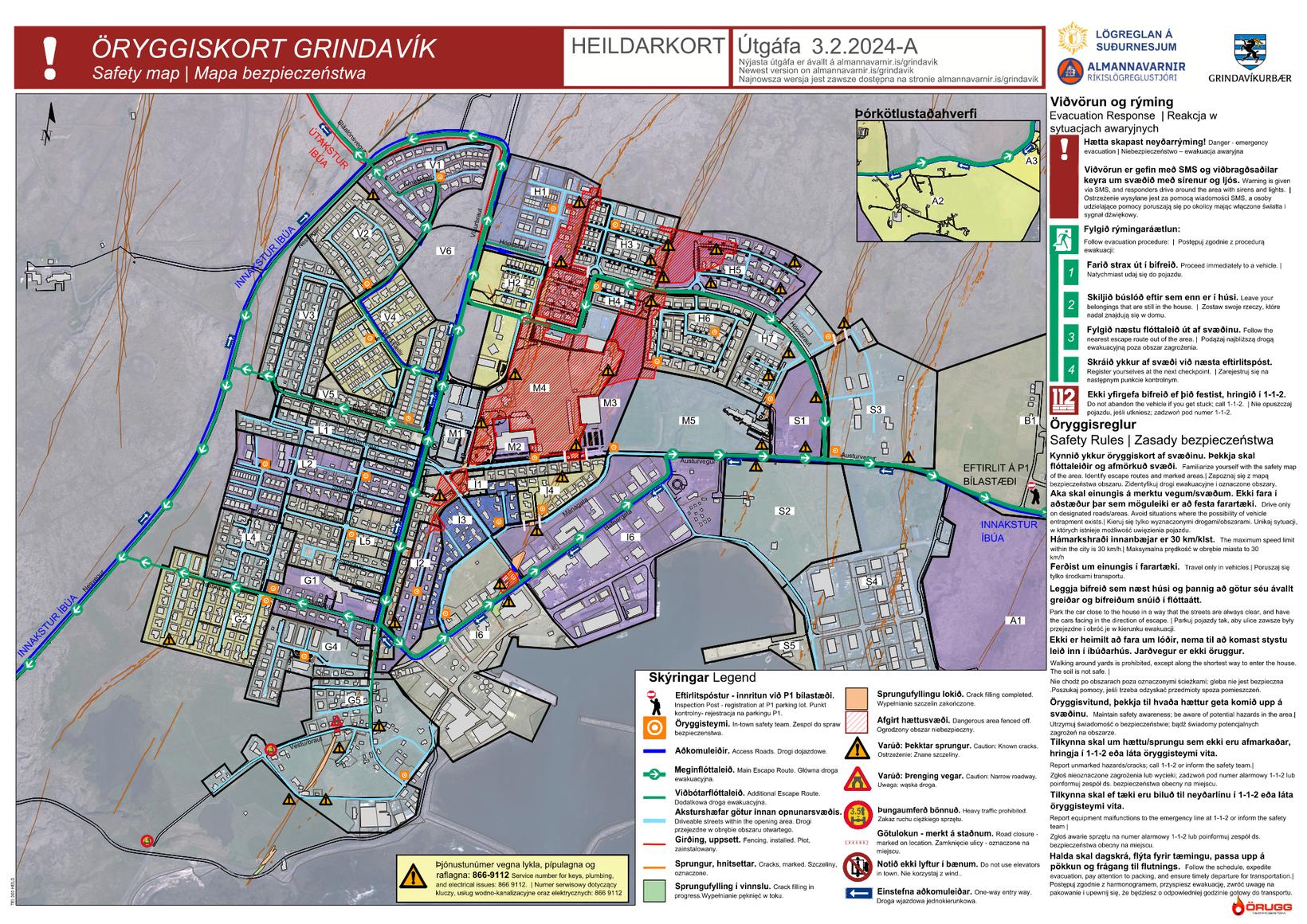
It was Vesturhóp – which is the square yellow area indicated H2 on the above map
For anyone asking who the man who fell into the crack is, there is a bit of info on that:
https://www.dailymail.co.uk/news/article-12966089/amp/Search-Ludvik-Petursson-50-called-grandfather-fell-crack-ground-following-Icelandic-volcano-eruption.html
(I know, the infamous Daily Mail).
It is a really sorrow thing to think about. All that I could think of is what his family will feel? Most importantly, what if that was one of my family members? It is very tragic to think about…
This is what I believe to be the crack he fell into. I can’t but think about being stuck, claustrophobia setting in, like the Nutty Putty cave guy except smelling rotten eggs and damp down there. It is a horrifying thought to think about. I would not even wish that on anyone.
Thanks, and I feel the same. Can’t help but picture this every now and them because it seems like such an odd and mysterious way to go.
Lets be honest.
Its horrific and we must all feel for the man that perished.
One day just a normal day job,
next day a traumatic death.
As my mother repeatedly told me,
“life isn’t fair and don’t expect it to be”.
For most on this planet, it isn’t.
Wasn’t there also a crack on the west side of Grindavik, where the golf course was destroyed? There are cracks on the west side and on the east side of the graben which was caused by the sill.
https://icelandmonitor.mbl.is/news/news/2023/11/15/thought_this_was_a_lot_worse/
Indeed there is, although the golf course is to the west of the map.
Earthquake swarm starting in/around Grindavik?!
Looks like very calm weather today, so even the tiniest quakes get detected. I would wait until there’s a lot of quakes in the range M1-M2 before calling it a swarm.
The double line of earthquakes is visible. A new graben on the way?
Source for image: https://en.vedur.is/earthquakes-and-volcanism/earthquakes/reykjanespeninsula/
I find the line under Fagradalsfjall interesting. It’s a bit deeper than the Svartsengi dyke and there are a couple of alternatives that might explain it.
One possible explanation is that the deep feeder for Svartsengi lies towards Fagradalsfjall and the quakes are related to magma transport. After the summer eruption in 2023, there was a deep inflation source under Fagradalsfjall, but instead of a new chapter at Fagradalsfjall, the activity moved to Svartsengi. Maybe the accumulated magma found an easier way towards Svartsengi, and that’s what we’re seeing now.
Another alternative, which I find more likely, is that the line of qukes under Fagradalsfjall are triggered quakes that happen when the Svartsengi dyke is expanding at depth. The ductile brittle transition goes deeper under Fagradalsfjall than under Svartsengi, so when magma flows into the dyke at depth, there are no quakes under Svartsengi, because the crust is too ductile, but it causes stress at that depth which triggers the quakes under Fagradalsfjall, where the crust is brittle enough to result in earthquakes.
I’m no geologist, just an interested observer, and this is just my personal speculation. Feel free to shoot it down.
Not a geologist either :).
I think that there are at least two areas where magma is accumulating: one under Fagradalsfjall and one under Svartsengi. The quakes to the east and west of these area are the crust fracturing to accommodate the uplift (triggered quakes?).
What is also interesting is that green stars at Vatnajökull and Myrdalsjökull have preceded the swarms leading to recent eruptions on the Peninsula. I assume any link would be tectonic.
Vatnajökull and Mýrdalsjökull are so far away that any relation in the timing between the volcanoes there and events at Reykjanes is purely coincidence. Katla and Bárdarbunga both do M3+ quakes on a regular basis.
It makes sense there would be tectonic shifting much further abroad. Reykjanes seems like an insignificant part of Iceland when compared to the hotspot but it is where the MAR surfaces and as such has a huge affect on the tectonic environment.
I remember a long time ago early on this blog it was always discussed that the Laki-Veidivotn rift zone would go south and take over from Reykjanes, but the data I can find doesnt support that. Katla seems to be almost entirely an intraplate volcano that has only had one rifting event in the Holocene (Eldgja), and Eyjafnallajokull, Vestmanneyjar etc are all alkaline intraplate volcanoes too. Hekla is not, and seems to be the actual plate boundary volcano. The boundary goes down from Bardarbunga to Hekla and Torfajokull, turns into the SISZ, and then into the Reykjanes fault once it passes by Hveragerði. Reykjanes has also long been one of the most seismic parts of Iceland, it seems the designation between the SISZ and tbe Reykjanes volcanic zone is only the presence of frequent volcanism at the latter, from a seismic system point of view the whole line from the Reykjanes Ridge to Hekla is a single feature. In fact Reykjanes is much more seismic than the SISZ even.
https://encrypted-tbn0.gstatic.com/images?q=tbn:ANd9GcRnxiAmFmk7gppujWeteMHqYVr8cMFEa3c_WA&usqp=CAU
https://encrypted-tbn0.gstatic.com/images?q=tbn:ANd9GcRHa3ZLJWBmtDepiaMnHGzHKp7NncZJB3if5g&usqp=CAU
I’ve sometimes thought about whether there is a local small hotspot below Fagradalsfjall that works like a dwarf version of Vatnajökull’s major hotspot that distributes magma to surrounding provinces and systems. The three eruptions of Fagradalsfjall until now reminded more to hotspot eruptions than MAR eruptions. They were similar to the eruption style of Piton de la Fournaise. We could witness this last summer, when both volcanoes were active during the same time and showed very much the same behaviour. The period of the fissure eruption was short, afterwards the eruption from a localized vent dominated the whole eruption time. That’s unlike Svartsengi’s Curtain of Straw Fires.
Grimsvötn, depth 1.6 to 3 km, the strongest with Magnitude 1.8:
It did a few cyclic swarms before the last eruption, quite a few quakes over about a 6hr timespan followed by calm. I could foresee another one tomorrow, but it cant be far away now. I’d take a punt on friday evening.
Time to watch the webcams. Looks like the swarm has started.
yes, agreed.. keep eyes on the cameras
notable quakes near grindavik … just began 20 minutes ago
its already going!!
That was quick. Looks like it went north this time.
where is the sylingarfell webcam?
it shows up in the ruv mosaic but i can‘t find it as separate cam
Fissure is shorter than the first time but the fountains seem higher to make up for it. Impressive display of awe-some! 🙂
It’s probably still unzipping. Both previous eruptions started will a short fissure that grew a lot larger.
Best webcam right now:
https://www.youtube.com/live/iKVwD_JZmFA?si=cUiTJLf1b9watnUq
First reports say it started north of Sýlingarfell. That’s east of the Blue Lagoon and maybe a little bit north.
Wow I dont look for 2 hours and it starts 🙁
Not next to Grindavik but it looks like this eruption is putting out a lot of lava, at least it seems to be flowing further from the fissure and both directions. Theres a very fast channel to the left on the Þorbjorn cam, the lava walls are for sure getting tested.
Tell me about it. I checked RUV and the vedur.is when I woke up Went off to the office, and when I arrived it was already fully going !
https://livefromiceland.is/webcams/fagradalsfjall and https://livefromiceland.is/webcams/langihryggur are impressive!
You can see where the eruption is taking place on this map: https://vafri.is/quake/#close. Set the time for 30 minutes.
Can anyone find a live RUV feed? (so we can go backwards in time to find the actual eruption start?)
At 6:02 you can see the start on this camera: https://www.youtube.com/watch?v=iKVwD_JZmFA
Looks there’s car headlights driving just where and when it started!
06:02:04 am on this camera, officially start time – thanks!
The one Thomas linked to above at just after 6am caught it although with the bad contrast it’s just a big orange blob.
https://www.youtube.com/watch?v=804nPrAUAxg
“Live from Iceland” – can access individual cams from his youtube “homepage”
https://www.youtube.com/@liveiceland/streams
That’s the most magnificent show yet, fountains! (Feel guilty saying that, ‘cos, Grindavik. :>( )
https://www.youtube.com/watch?v=8bfcTBLvPiM at 06:02:07 am Iceland time as close as I can estimate fissure eruption start time
Now all we have to do is find the closest camera and get lucky with a live shot.
I wondered whether it was imminent when the quakes went quiet last night.
The fountains to the left of the screen are impressively high, can anyone estimate? I would guess 80-100 meters in height maybe more? See https://livefromiceland.is/webcams/fagradalsfjall (7:20 am)
¬Diane
07/02/2024 at 01:03
The borehole story is still on ruv.is. https://www.ruv.is/frettir/innlent/2024-02-05-borholur-gerdu-vidvart-um-eldgosin-404094”
Doh! Thank you Diane, I searched, but not well enough, obviously!
Interesting that the people at HS ORKA predicted the january eruption going South, which it did!
There seems to have been very little warning. No evidence of tremor in the lead up and the first quakes were less than 45 minutes before the start.
I see less than 30 minutes or so, but it is difficult to tell because the quake screen is jumping around. Too bad a person cannot select a time period to scan. See https://vafri.is/quake/#close
I estimated about 40 minutes from the first quake on the drumplot. Of course, that in itself wouldn’t have given any clues. Even at 30 minutes, I don’t think it really stood out as the start of a swarm, aside from being stronger than previous pulse of quakes.
I see 05:38:30 am or so from this seismograph but like you said, it would be hard to tell.
There was a 1.9 and a 1.8 (unconfirmed) at 5.26. Bigger ones followed after the start.
This eruption looks like it is almost in the same place as the eruption in December except unlike then lava managed to flow to the west of the old Sundhnjukur spatter cones, so there is now a huge volume of lava flowing west and presumably down that valley towards Svartsengi and the Blue Lagoon.
There is a nice height map at https://map.is/base/@332709,378180,z8,0
Open the menu “Jardeldar i Grindavik” on the right, choose “Hædarlikan”. You’ll see a detailed height map of the area, including the protection walls. And you can overlay with lava (“hraun”) and other features.
Thx! Indeed close to the December eruption.
IMO have estimated the fissure at 3km, with slightly less flow rate than December on today’s update.
Nicely visible also from Reykjavik

Source https://livefromiceland.is/webcams/perlan3:
New livestream showing the lava flowing out onto the plains north of Svartsengi.
https://www.youtube.com/live/kRIAT5Rvssw?si=NtrDVEVxO60a1Opf
Shaun Willsey has a really good topography map of the exact area of the eruption on his video called Drone Flight Over Iceland’s Newest Lava Field: Livestream with Geologist Shawn Willsey
On 22 Dec 23 from about 34 mins in
https://www.youtube.com/watch?v=-iWWgOqGsjg
It really clearly shows the flow lines and so can see how much at risk the road and BlueLagoon might be.
Someone sent him loads of maps.
At 38 mins in there is a map of topography from them end of the Dec eruption at what looks like the exact spot of this eruption!
Here is the relief
(Click to enlarge)
Sources: https://map.is/base/@342360,380100,z4,1
Here is the lava progress of roughly one hour (don’t let yourself be fooled by the cam’s varying exposure):
It seems the lava will reach the road fairly soon. Are there any berms to prevent it?
Perhaps a small berm:
Source: https://atlas.lmi.is/mapview/?application=DEM
Bu now the lava is really close to the road. The work commute for the personnel at Svertsengi might become complicated real soon. Good thing they evacuated the spa earlier today.
The lava is reaching the road as we speak. I don’t think much can be done anymore to prevent it overflowing. Close up view here:
https://livefromiceland.is/webcams/fagradalsfjall
And it seems that it will overflow in the junction between grindavik road and the Blue Lagoon and powerplant road! Just while I’m writing, it has overflowed! Pinpoint accuracy :(.
I think the berm is a bit further west of where it has crossed the roads. I think its by that black splodge next to the road on the Svartsengi camera. They might have time to fill the gaps yet. In fact I think I see a digger trundling in that direction right now!
The speed this road crossing is evolving is astonishing.
At this stream https://www.youtube.com/watch?v=VIs83vmfZCk (RUV Thorbjorn-2), at the 5:50h you can see all the heavy equipment rushing out of Grindavik merely minutes before the glow of the eruption is reflected on the slopes of the mountain! That was close!!
The Blue Lagoon’s assertion on its website that “The current eruption site is a safe distance from Blue Lagoon” may be in some doubt as the lava flows rapidly in that direction…
Using Chad’s link ( https://www.youtube.com/watch?v=kRIAT5Rvssw ) you can see that it is across the road now, and going straight on it appears – where does that path/small road lead ?
Still working there…
It is the main access road to the Blue Lagoon.
They are a bit in panic: building dikes to ensure the flow does not use this road too long.
Very soon it’s going to test the berm by the looks of it on the zoomed in view. That excavator was very brave, but I doubt that little bump in the road will do much to slow it down.
Yep, gone over and round !
Its really flowing very fast, which should help as the lava will be too fluid to easily flow over the berm without spreading out. The berm should hold but it really highlights what a large eruption might do if this one can flow so far in a few hours.
At least the cycle is fairly predictable, about once a month and 2-3 days of eruption. So long as this keeps up eruptions will be visually spectacular but relatively limited. The danger may be when that cycle fails and a longer gap happens, perhaps from waning supply. Slower feed and longer interval might let much more magma build and a much larger eruption.
This might also be from a new rift too potentially. Eldvorp seems to have been formed from the same sort of high intensity fast eruptions as now and covers a huge area but no more than a few km from the fissures. Arnarseturshraun by contrast is on a different fissure and a single much larger eruption that still erupted well beyond the curtain of fire stage. Although Eldvorp and Arnarseturshraun are probably 15 years apart so maybe not that closely related.
That does not look good. The berm is still open and lava is approaching fast. Dig excavator dig!
Wow! This is a real time thriller. Ep.6 started and escalated quickly. Seems the lavaflow hit some uphill terrain behind the brim right to the west of where they fill the brim just now, so it will be difficult to determain if it starts spilling towards were they are working. Hope they all have good personal protection. Incredible to watch and the lava seems faster than before too.
https://livefromiceland.is/webcams/fagradalsfjall
The news is reporting that the hot water pipe that heads northwest to the populated areas of Reykjanes may be over run in the next few hours. That will cut off all heat to 30,000-ish people. It is very cold right now….minus 11C or 12F. They are telling residents to turn down their heat and not shower so that the hot water in the storage tanks can last for a few days while they race to complete a bypass line. They are also telling people to not use portable electronic heaters as the grid can’t handle it. The only thing worse than losing that hot water pipe would be to lose the power plant itself.
Have you noticed if the steam on the Svartsengi cam for RUV is new, or has it been there for some time this morning?
The IMO has updated its hazard map. Oddly, Zone 1, which has fast flowing lava actually running through it as we speak, is still not assessed as having a high lava flow hazard (only “considerable”)…
New water pipes being laid already.
Lava advances 500m/h in some directions
Live blog by Icelandic national broadcaster
https://www.ruv.is/english/2024-02-08-eruption-started-on-reykjanes-peninsula-404272
Looks like the steam pipe exploded a 12:07:08. The camera went black briefly then there’s a huge amount of steam. 🙁
Is this the explosive vent the Webcam below shows?
On the Svartsengi camera https://www.youtube.com/watch?v=kRIAT5Rvssw
The eruption is now about 6 hours old and still a raging curtain of fire, and the lava has flowed much further than before and is still moving like hot olive oil even over flat ground. I wonder if maybe that ‘skipped’ deflation during the January eruption means this eruption actually has a lot more than the 9 million m3 that was estimated. Maybe the January eruption was a different sill, and what is erupting now has been building since December.
Watching this now makes it pretty abundantly clear how badly Hafnarfjordur is located. The lava of Kapelluhraun was an intense curtain of fire like we see now only probably 5-10x the volume, abd the topography funneled all of that to the coast next to the aluminium plant. Seeing how fast this lava is flowing makes it all to easy to visualize. Not to mention those terrifying flows on Mauna Loa in 1950, which erupted about 0.3 km3 of lava down a 20° slope in less time than this eruption has lasted so far… 🙂
Here the Webcam shows an explosive (phreatomagmatic) vent with strong white steam and tiny black ash plume:
The lava flowed over a geothermal pipe which burst. So no new vent although maybe it will form a pseudocrater/littoral cone if it keeps up. The worlds first artificial pseudocrater
The black/white plume looks like a dwar version of Grimsvötn’s typical eruptions. Imagine this on the Vatnajökull glacier, then it’s Grimsvötn
That would be lava interacting with the ice-cap if Vatnajökull. Has lava found a bigger source of water than the water pipe?
Only very dwarf version. But the bi-modal black/white plume is typical for Grimsvötn. Water makes white steam plumes, Ash makes black tephra plumes. The black color also is different to evolved silicic ash plumes, that often are more grey to light grey.
Think the pipe has gone