Iceland can do surprises. Its main activity is in a limited number of volcanoes which can erupt anytime, with frequencies ranging between once per century to twice per decade. These are the usual suspects, including Grimsvotn, Bardarbunga, Askja, Katla, Hekla, Krafla. (Grimsvotn is the only one not ending in ‘a’.) The beasts can go small or big, and do fire eruptions or explosions – they are like a box chocolate, as Forrest Gump famously said. In the current decade, we have added the Reykjanes peninsula to the list. There are other volcanoes in Iceland, but their eruptions are much less frequent. An eruption from a volcano with a dormancy of many centuries always comes as a surprise – as we have seen with the original Fagradalsfjall eruption.

Source: Postglacial volcanism in Iceland, Thorvaldur Thordarson and Ármann Höskuldsson, Jökull, 2008
Icelandic volcanoes are associated with a number of rift zones. (The number is 9, to be precise, including the submarine Reykjanes Ridge.) These zones are some tens of kilometers wide but can run along the length or breadth of Iceland. Within the zones are the individual volcanic centres (30 in total), typically consisting of a central volcano (there are 23 of those), often with its own fissure swarms (19) which can extend for 100 km or more. Not all locations have central volcanoes: the Reykjanes peninsula, for instance, can erupt anywhere and does not revisit an old cone (other than in different episodes in the same eruption). On the other hand, a few volcanic centres have two central volcanoes.
Eruptions in different volcanic centres are mostly independent events, but as the eruptions can last for years to decades (such as in the Krafla fires – this can be seen as a single eruption or a series of related eruptions), two different systems may still erupt at the same time, largely by coincidence. There are suggestions for phases of enhanced activity across Iceland, but we have not enough data yet to know. Give it another thousand years.
Of the 8 on-land volcanic zones, the eastern volcanic zone (EVZ) is by far the dominant one. Around 70% of the known eruptions (not counting the Reykjanes Ridge where no good data exists) have occurred here. Second on the list is the northern zone (NVZ) with 12%, followed by the western zone (WVZ) with 11%. The outliers are the also-rans: the Reykjanes Peninsula (RV) accounts for 4%, and the Öræfajökull Volcanic Belt (OVB) and the Snæfellsnes Volcanic Belt (SVB) for 1% each. Finally the Mid-Iceland Belt is almost a goner with 0.1%, making one wonder whether it exists. Still, like Father Christmas, eruptions can show up anywhere. A 1% chance is not zero.

Source: Postglacial volcanism in Iceland, Thorvaldur Thordarson and Ármann Höskuldsson, Jökull, 2008
The Snæfellsnes Volcanic Zone (SVZ) is the odd one out in Iceland. It is disconnected from the other zones. The peninsula traces an ancient transform zone, 7 million years ago, which was abandoned when the transform zone moved south to form the Reykjanes peninsula. But althogh there is no longer any transform movement or rifting, it did not go fully extinct, or perhaps it re-activated in the past million years. The last known eruption here, mentioned in the Book of Settlement, was 1000 years ago.
The SVZ contains four distinct volcanic systems. From west to east, these are Snaefelljökull, covering about 600 km², Lysuskard (150 km²), Ljósufjöll (1,800 km²) and finally Snjofjöll. Snaefelljökull may have had as many 30 eruptions in the holocene, Lysuskard (around the mountain range labelled Snaefellness on the map) had two and Ljósufjöll some 20. Snjofjöll has not erupted in that time and may be extinct: it is normally left off the list. Snaefelljökull is surrounded by lava fields of a variety of ages but the youngest age is 1750 years. (One field may be a bit younger.) Ljósufjöll has a similar number of lava fields but they are not well dated. However, the report from the Book of Settlement confirms that the most recent eruption of the region was here, around 960 AD.
Based on averages, this area is now overdue an eruption. But of course, volcanoes don’t do schedules and any argument of an ‘overdue eruption’ hardly ever works. However, there is still some seismic activity on the peninsula. Micro-earthquakes up to M1 have been found under the southern flank of Snaefelljökull, at a depth of 9-13 km. These have been attributed to a local magma chamber, albeit one that seems happy to remain where it is.
Ljósufjöll
The Ljósufjöll volcanic system extends for some 100 km, from the north coast above Sejafell to the start of the peninsula. At the northwestern end, the lava field called Berserkjahraun is located. The southeastern end point is at a crater near the town of Bifröst (yes, that does exist). There is a central volcano, 1km high, which has had rhyolitic eruptions, but it has had only a few eruptions since the ice age. The central volcano has also produced basaltic tephra. It is an ancient region: the oldest dates for silicic lava are over 1 million years. (In Iceland, silicic eruptions are associated with central volcanoes and their flanks. Rift eruptions are normally basaltic.)
The Ljósufjöll eruptions in the holocene have mainly been on fissures away from the central volcano. The eruptions here have made use of older faults which allowed magma to come up and formed short fissures and small craters. These are not rifting events: rifting has long since moved elsewhere in Iceland, but the faults are still there.
The volcanic system changes appearance between west and east. In the western region, the volcanic system is narrow and well-defined: the width is only a few kilometers. In the east, the volcanic region becomes much wider, with a spread of some 20 kilometers. The western eruptions have been much larger than the eastern ones. In the east, eruptions tend to be in the valleys rather than the hills. This includes the two valleys of two valleys, Hnappadalur and Hitardalur, both south facing with lakes at the top. One may expect that eruptions here have a phreatic component. The fissures tend to be short and the lava volumes limited. The magma is alkali-basaltic, from the mantle with only a small amount of crust melted into it. The eruptions formed scoria cones.
A number of the eruption products have been dated to be between 100,000 and 200,000 years old. Four eruptions are known to be younger than 4000 years, which includes the lava with the most worrying name in Iceland, the Berserkjahraun. These eruptions were between 500 and 1500 years apart. Their basaltic composition shows that the magma flows can bypass the central magma chambers which fed the rhyolitic eruptions. The basaltic magma rose from the mantle, but whether it came up underneath the central volcano or elsewhere is not known.

Source: icelandicvolcanoes.is The pink region shows the most recent lava flow, Rauðhálsahraun
The 960 AD eruption
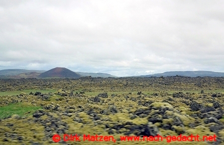
The moss-covered Rauðhálsahraun. Source: https://www.nach-gedacht.net/reiseberichte/island/snaefellsnes.htm
The most recent eruption around 960 AD formed the so-called Rauðhálsahraun. The lava covered around 13 km2 within the valley of Hnappadalur. The volume of the eruption may have been up to 0.1 km3. According to the Book of Settlement, the eruption took place in Eldborg crater, but this is wrong. Eldborg is a beautifully complete ring near the coast which erupted some 5000 years ago but not since. The 960AD (within a few decades) occurred further north, up the valley.
The Rauðhálsahraun flowed from (and is named after) the Rauðhálsar scoria cone, at the eastern end of the lava field. The cone is 80 meters high and measures 500 by 300 meters. Within the crater is a smaller crater which is over 20 meters deep, presumably from an individual explosion during the eruption. There is an ash layer associated with the eruption which extends about twice as far as the lava, and which reaches a thickness 10 to 50 cm. The eruption started with a phreatic phase, before the lava began to cover the land.

The Rauðhálsar scoria cone. Source: Haukur Johanneson, 1977, Náttúrufræðingurinn, 47, 129-141
The eruption occured during the earliest settlement of Iceland. This is clear from the peat, which changes colour from black to brown from below to above the ash layer, a colour changes that has been attributed to human activity. The Book of Settlement mentions a town (or farm) called Hripi occupied by a old man called Thorir, which was burned down by the lava. The Rauðhálsahraun covered vegetated land, and it is plausible that a farm existed there. The date assigned to the eruption, 960 AD, was derived base on the assumption that Thoris was one of the original settlers, most of whom arrived between 890 and 910 AD. After the eruption the land was no longer farmable and was forgotten. The story was therefore associated with Eldborg, impressive and much closer to the coast where it was still easily accessible.
A new swarm
This is not a likely location for the next Icelandic eruption. Carl, in the Mammoth guide to Icelandic volcanism (essential reading to find out about those Icelandic volcanoes you never heard off) gives it the lowest risk ranking of 1. Still, there is just a little brewing of something there.
Since August, there has been some earthquake activity in the region of Ljósufjöll. The swarm is located southeast of Rauðhálsahraun, between the lakes called Haleiksvatn and Grjótárvatn. This is still well within the eastern zone, in the region where the eruptions have been widespread although generally small. The earthquakes have reached magnitude 2 to 2.7, and are at a depth of around 15 km.

Location of the current earthquake swarm
The activity is not new: it seems to have started in May 2021 when it culminated with a M3 event in July that year, before diminishing. In August this year the activity picked up again, increasing to some 100 registered earthquakes during October. As of this moment (17 Dec 2024), there have been 43 earthquakes in the past 7 days.

Source: https://www.volcanodiscovery.com Earthquakes in the area over the past 90 days.
The activity seems to be on a deep fault. There is no indication that magma is involved. But in this region, the faults are an intrinsic part of the volcanic activity: the magma uses these faults to find a way to the surface. Although the activity is tectonic, the duration suggests continuing stress that is not being resolved easily.
We do not know what the precursor activity to an eruption in this region will look like. Because of the lack of shallow magma chambers, it is expected that deep earthquakes will play a role, especially if long-lasting. The build-up may be intermittent, and may last months to years or even decades. We just don’t know what to expect.
If an eruption were to occur, we can expect it be minor and tourist-friendly, although small phreatic explosions are not unlikely so the tourists should not get too close for comfort. Luckily, although the region is accessible, it is quite a walk from the main road.
But this gets ahead do the facts. So far this is just a long-lasting, minor earthquake swarm. It is just another region to keep an eye on.
Albert, December 2024
The post has made use of the information in the Catalogue of Icelandic Volcanoes, and the paper by Haukur Johanneson, 1977. Náttúrufræðingurinn, 47, 129-141, kindly translated (approximately, at least) with help of giggle.


Deep Earthquake swarms are always interesting but I doubt the volcano is going to anything soon even if it’s recharging.
Most swarms don’t. But it is worth investigating deep swarms in volcanic regions which increase over time. It may well lead to an intrusion, although again most of those do not reach the surface.
And now Hofsjokul has joined in. These are shallow quakes, perhaps related to stress release as the ice cap reduces.
Glacial volcanoes can be so annoying. Glacial process can cause swarms and deformation, which leads to false hope and puts a damper on excitement when something does starts.
Juno spotted this new glowing lava channel in infrared on Io flowing out from a ponded flow, lake on Zal on Io, the lava is very likey flowing from a vent in the mountain complex and into the pooled lava flow/ lava lake at Zal Patera.. the line of thermal emission is similar in shape to Tawhaki Vallis so coud be a glowing lava channel
I wants more space – probes for Io … the ultimate volcano world
And the Ionian Masubi 1600 kilometers long pahoehoe lava flow remains active as seen from Juno Spacecraft, its completely unknown if the flow front is still active, but a new flow front is growing from the vent likey feed from a vent lava lake feeding into buried lava tubes feeding the lava field.. this maybe analougus to the ancient Rhajamundry lava flow in Deccan that was also pahoehoe on a huge scale
HVO is moving from weekly to daily updates in Kilauea. No immediate changes but an eruption or intrusion may be becoming closer. So far the activity seems to be mainly at the summit though
They observed:
“increasing amount of magma is being stored underneath the summit area.” and “Starting in the early morning of Saturday December 14, there have been a few periods of increased seismicity activity, lasting from one to a few hours, often accompanied by minor inflation as recorded at the tiltmeter at Uēkahuna, northwest of Kaluapele, the summit caldera, and tiltmeter at Sand Hill, southwest of Kaluapele.”
If an intrusion begins at the summit then its 99% going to erupt. Only time I can think of that a summit intrusion failed was in the 1940s when Kilauea wasnt very active, and in 2020 although I dont know if that is fair given an eruption happened a month later anyway.
And it will be fast, like if the tiltmeter sharply spikes or drops out then watch the feed like a hawk, there will be lava within 2 hours. I also think if the summit is this inflated and the vent isnt under the lava lake, then the opening stages could have some serious lava fountains. The last summit eruption in 2023 looked like lava foam it was that gas rich.
Now I have said this of course the next intrusion will soon begin east of Pu’u O’o… 🙂
Can we get a tiny summit eruption like those 1982, before the MERZ erupts again with a major eruption?
Well yes, but im not sure it will be that small. If it is up on the caldera rim or in the south caldera or upper SWRZ, then it will probably be similar. But an eruption in Halemaumau will probably be pretty big.
I think nowdays it might not be possible to get a tiny eruption within the caldera itself, back in 1983 the summit was high up and the caldera was filled with solid rock, unlike now. The magma system back then was also maybe more of a sponge of dikes and sills, where since about 2011 it has dissolved into an actual singular liquid magma chamber that partly collapsed in 2018 but wasnt destroyed. So there is more pressure. All of the post 2018 caldera eruptions have been pretty big, from 15 million m3 to over 100 million m3.
Sometimes Kilauea did “pair eruptions” with first a summit and then an ERZ eruption (f.e. 1955 or 1960). Often this happened with lower ERZ eruptions, but can it also happen with middle ERZ eruptions?
I dont know if the eruption pair idea is real. It might be for Mauna Loa but Kilauea basically only has the pair of Kilauea Iki and Kapoho in 1959-1960, and that was probably a massive surge of magma that began the modern era of high activity. Theres really not much consistency of location from one eruption to another otherwise, although the main vents of Mauna Ulu and Pu’u O’o did form in places where eruptions had been more common before.
So lower ERZ eruptions might have a precursor eruption higher on the volcano but otherwise its pretty weak.
A good view of just how active Kilauea has been in the last few years. About 1.8 meters of extension across the caldera. Likely more than 2 meters since 2018.
This also despite filling Halemaumau 400 meters and most of the magma going to the rift zones for the last 1.5 years.
I have noticed too that recently there have been a few more deep quakes between the Pahala swarm and Kilauea. Not huge numbers, but it is hard to ignore them, considering they are happening in the upper mantle underneath what is probably the hottest of all volcanoes. Pahala quakes flared up enormously right after a caldera collapse at Kilauea followed by increased magma supply there that has held up in both regards, while doing absolutely nothing after Mauna Loa erupts nor responding directly to any changes either there or at Kama’ehuakanaloa, seems pretty obvious what is happening there really im not sure why HVO has said it is ‘hard to see connection’.
Simplest answer, Kilaueas magma system rises through the mantle fault zone, magma also accumulates in the fault zone at times, and it finds a way out. It doesnt go to Mauna Loa because the faults probably dip down towards the center of the island, and magma rises.
Yes, that flank does have a case of the fidgets…
( As has US West Coast, presumably nudged by Cape Mendocino’s strip of descending plate. Hmm: Does that strip extend East to the deep swarm at Carson City ??.)
I thought my eyes were playing tricks when I read (USGS event map) that one small-ish H quake had a *negative* depth, IIRC ‘-0.2 km’.
But, given size of edifice, that’s just magma ‘feathering’ a local fault: Nothing to see here, yet, folks, move along…
Thanks for the update on Ljosfjöll, Albert!
What drives volcanism there if there is no rifting? Do the magma chambers have to reach a certain point of pressure to do an intrusion or eruption? Or does the Hotspot / plume shift/expand to western Iceland occasionally?
It was hard to find much information on the system. Of course as long as magma is less dense than the crust, it will push up. There is normally a depth where the two are in equilibrium, but as the magma evolves the denser materials drop out and what is left becomes a little less dense. That drives silicic and rhyolitic eruptions. The basaltic eruptions probably come from a bit of new heat. At Reykjanes, the trigger was the series of large earthquakes along the transform fault which reduced stress, allowing the magma to come up – after waiting for 800 years. Here, there is no such trigger so it is just a matter of pushing on old faults until they begin to give way. I assume that is what is happening here.
Nusky on Io also had a huge recent eruption this looks like a Pele type plume so likey is sulfur snowfall freezing out from basaltic lava fountains
I had noticed that even on the MIB zone over the past week that Hofsjökull has been shaking a bit, those don’t seem to be the glacier sort that you see at Katla every so often either.
I’ve been keeping an eye on the Snæfellsnes swarm at IMO. Yes while most of the tremors are very deep there have been a dozen or so shallow ones. The latest two about four hours ago were M1.8 at 3.5 km and M1.3 at 1.1 km.
Whether this means the stress and pressure is cracking apart a vertical fault I have no idea. But a depth plot would be interesting to see.
Looks like planet 9 will be found soon, or proven not to exist. But even if that is the case we might well find something planet sized but much smaller orbiting out there. Something like Pluto or Eris but the size of the Moon or Mercury, or even Mars, after all there are several moons of that scale and probably lots of planets ejected in formation, some of which probably didnt quite escape. Or maybe better evidence by which to judge if Pluto and Eris should actually be considered the same object as the defined planets, meaning actually there are 10 or more. Lots has changed since 2006.
https://www.scientificamerican.com/article/if-planet-nine-exists-well-find-it-soon/
The advent windows still open in the previous post!
Dec 18
To quote Doctor Who, there is always a twist at the end. Volcanoes may not do much to the climate, they certainly can affect the weather. One aspect of this comes from the heat which causes the heated air to rapidly rise. A slight deflection to the airflow will twist the air, and a twister forms. This is the volcanic counterpart to dust devils. They were often seen on or near the lava fields of Iceland during the Reykjanes eruption. Once formed, they tended to meander and at times attack the nearest camera. The image from 2009 shows a lava ocean entry in Hawai’i. The rising plume of vapour above the hot layer of air just above the water triggers the formation of vapour devils. This spectacular picture has 6 of these, plus a 7th one trying to survive.
Image Source: Bruce Omori, https://uk.news.yahoo.com/incredible-photo-shows-hot-lava-155400167.html
Reykjanes can do this too. This video from July 2023 (Fagra episode 3)s hows a large volcano twister which (about 4 minutes in) breaks up in a series of small twisters, circling one another. The dance of the 7 veils – with a twist.
https://vimeo.com/manage/videos/849756648
If warnings are ignored, this could be the dumbest thing that we’ve ever done as a species. Is this really needed now and if so what’s the damned rush?
https://www.theguardian.com/science/2024/dec/12/unprecedented-risk-to-life-on-earth-scientists-call-for-halt-on-mirror-life-microbe-research
And right on cue…. https://en.vedur.is/earthquakes-and-volcanism/earthquakes/snaefellsnes/
Snæfellsnes gets a coveted star!
Very deep though: M3.2 at 18.2 km depth.
How is that for timing! But at the edge of my circle: almost a miss. Also a bit deeper than previous one.
https://www.facebook.com/share/p/1AynwXN1kU/
About Hofsjokull, seems it really is getting more active, although it doesnt say it is because of magma exactly.
Hofjsjökull is a pretty glacier, but I think it is as a volcano nearly extinct.
Extinct maybe not, but it is mostly inactive. I think the volcano might be old and has maybe had several waves of activity for a few million years. It is quiet now but the size of the caldera and length of the fissure swarm hints that at times the magma supply must be very significant and probably comparable to or even more than Bardarbunga now. Being that Hofsjokull isnt really on a plate boundary directly, it probably erupted more of its total supply and might have been a real monster at peak. Its pretty likely Langjokull is similar to this, and both will probably flare up in the future again too.
During Holocene Hofsjökull did some minor lava eruptions: “The known Holocene volcanic activity includes 6-7 effusive basaltic eruptions, while no tephra layers have been traced to it. The largest lava flow covers about 37 km2, its volume is possibly 0.3-0.4 km3”
This reminds me to Fagradalsfjall’s 2021 scale. The worst case – which didn’t happen during Holocene – is something Rhyolitic at Kerlingarfjöll.
Im not sure why a rhyolitic eruption is always given as worst case. All the Icelandic volcanoes that produce it are pretty effusive, if there is any ash it is because of water interaction. Except Oraefajokull but that was still probably a big part phreatomagmatic and its usual show is much smaller.
Tbe most consistent and voluminous explosive volcanoes in Iceland, Snaefellsjokull and Hekla, are andesitic and also still mostly effusive by volume, just prone to paroxysm eruptions. But they do explode on their own, Katla and Grimsvotn are more explosive in real life but wouldnt be at all without the ice, both would be lava shields like the Galapagos calderas.
I know going back there are some proper explosive eruptions, like at Krafla being an actual ignimbrite, and at Torfajokull. But without extremely accurate dating and in the absense of thick deposits in Iceland itself that I am aware of, I would assume most distant tephra layers from Iceland probably erupted in the presence of ice.
One other thing about viscous magma too, seen at Ho.e Reef and Lateiki in Tonga, if erupted effusively it doesnt even do surtseyan eruptions. Ironically, fluid magma explodes in water way more, and much more violently.
Dec 19
On 22 December 2018, Krakatau became famous for a second time. After the cataclysmic eruption in 1883, a new volcano appeared above the waves by the 1920’s, at the location where Verbeek had predicted it would regrow. The new mountain became one of the most active volcanoes in the world, where different from old Krakatoa which had several centuries between eruptions. By 2018 it was some 400 meters tall and its eruptions were spectacular to see. The photo was taken on 19 July 2018. But its demise was already in progress. The flank was beginning to give way. In December, the collapse came. It caused a tsunami. To everyone’s surprise, when the dust cleared, the entire volcano was missing. Not only the flank but the whole cone had slid into the sea. The collapse and tsunami had been predicted but the warnings had not been taken serious enough. And so a volcano was lost – again.
And there were no tsunami warnings. “The official number of human casualties reported was 437 dead, 31 942 injured, and 10 still missing as of completion of this report (BNPB, 2019). Local communities received no warning of the 22 December 2018 tsunami that was generated by Mount Anak Krakatau. This was one reason for the large number of human casualties on both sides of the affected area.”
https://nhess.copernicus.org/articles/20/549/2020/nhess-20-549-2020.html
Too many victims methinks.
Do Iceland’s volcanic systems have triple points? F.e. the one between EVZ, NVZ and MIB (not Men in Black, but Mid Icelandic Belt) in the region of Holohraun. Also Langjökull looks a bit like a weak triple point between WVZ, MIB and SVB
There seems to be a triple junction at Hengill, where the Reykjanes faults trend into the south iceland seismic zone, while the Þingvellir rift goes northwards. But, there isnt really another equivalent fault from Langjokull to the north volcanic zone, so I dont know if this really counts as a true plate boundary rather only as a tear. Hofsjokull is in a spot that would be where a boundary would be, but its fissure swarm is in the same direction as neighbors so I think the boundary going through this is imaginary.
Only other option is that the faults at Tjornes and Husavik are two parallel faults, so probably make a small microplate, but theres no exaggerated volcanism near it.
Being back from America I can finally start to understand what people like about Iceland having been in Death Valley (Basin and Range) which created a strong impression in my brain.
Driving from Las Vegas to Santa Monica we spend much of a day in a barren landscape, in Death Valley itsself in a history book about plate tectonics with visible traces of old volcanism, oceans (salt, sand dunes and sediment), driving through the lowest part of North America, comparable to parts of the Caspian Sea and Dallol, Ethiopia, also seeing the highest mountain outside Alaska.
In Alska that is Denali (McKinley), in California Mount Whitney.
I never understood Plate Tectonics in California and the West, now it is clearer to me what was going on there. Those are probably the remnants of Laramidia, once full of life, utterly fascinating.
Time to visit Iceland one of these days. Iceland is new though. The American South-West is one of the oldest landscapes of the world shaped by Plate Tectonics, subduction and volcanism, oceans and mountain building, awesome. And breath-taking to see the Pacific Ocean for the first time which made me dig out these pieces for my son:
https://www.volcanocafe.org/hawaii-and-the-story-of-the-pacific-ocean/
https://www.volcanocafe.org/wrangellia-how-the-west-was-won/
plus two more about Wrangellia
Well, Albert, in case you see this, these were always my favourites and accompanied me while seeing part of these miracles for the first time. Thank you. Would have had less fun without this knowledge. VC made my life richer.
Accordingly my attention was caught right away by the “Devil’s Tower”, Advent Calendar, 17th, although we haven’t been to Wyoming. The link to an abstract is nice, the abstract has a gross mistake though: no data. The butte!!! is thought to have formed around 40 Ma. Well. I don’t see any water there aside from some rivers at a distance, and I believe there wasn’t that much water there 40 Ma.
PHREATO-magmatic events needs water, so I think this is just a new interpretation, but the older ones might be more solid.
“Geologists Carpenter and Russell studied Devils Tower in the late 19th century and came to the conclusion that it was formed by an igneous intrusion.” Lit. 18: “A Report on the Geology of Devil’s Tower National Monument”, William A. Effinger.
https://en.wikipedia.org/wiki/Devils_Tower
These were only the first to go there, there are numerous interpretations of the butte.
No water: Eocene map from wikipedia:
To make sure there was no significant water around I studied another map in a piece about Texas in the Eocene:
https://www.researchgate.net/figure/Paleogeographic-map-of-the-early-to-middle-Eocene-53-to-47-Ma-in-the-United-States-and_fig2_344292641
The yellow area is mainly Texas, west and north of the Gulf of Mexico. The map scrolling left is also interesting. I is altogether at least 500 miles away from the Wyoming Craton, even at that time when the continental mass was smaller.
Full article can be downloaded.
I read the paper on the Devil’s Tower as proposing a moist area, possibly a lake in an older crater. It did not suggest a marine eruption. The Laacher See in Germany was a phreatomagmatic eruption but was not under water. In the Eocene (55-45 million years ago), Wyoming was tropical and humid in the early phase, with large lakes being present. It became drier later but by 40 million years ago (middle Eocene) was still around 1500 mm/year. It was certainly not a desert, and a crater can easily have held a lake. This paper is a change from earlier models which pose a solidified intrusion, but I have not found anyone arguing against it in recent years. The picture is that of a lava lake that later filled the crater.
Could be. But the Laacher See is a maar, whereas this butte is not alone. There are numerous buttes and mesas in the Colorado Plateau (Utah, Colorado, New Mexico, Arizona, albeit further south, but also some buttes in Wyoming, Oregon and Idaho and a lot in Montana.
Didn’t mean to criticize you, only the abstract.
Any similarities?:
Picture VC, Carl’s piece
https://www.volcanocafe.org/mountain-of-greatness-dvp-7/
This is the most similar one, albeit not that perfect:
Shiprock, New Mexico
Compare the hypothesis of a phreatomagmatic event to Nr. 12 in the Advent Calendar, the differences are obvious, the setting of Taal totally different with a lake and the the ocean around the volcano. Beautiful picture, great to see it again.
https://www.volcanocafe.org/taal-in-eruption/
I met lots of Filipinoes in California, and they told me that I should go visit the Philippines.
Concerning 16th dec Erta Ale, I knew that it was under sea level, plus the Eastern part of the Caspian Sea in Mangystau, Kasachstan and driving through the lowest part of Death Valley – the temperature rose from around 32F/0C to 50F/10C – I thought that was it, those three sisters. I couldn’t have been further from the truth. Here’s a list of depressions plus a list of numerous reasons for them, including of course meteorite impacts, Maar volcanoes, caldera collapses and rifting:
https://en.wikipedia.org/wiki/List_of_places_on_land_with_elevations_below_sea_level
https://en.wikipedia.org/wiki/Depression_(geology)
I’d like to add that Death Valley shouldn’t be visited between June and September. There are reports of deaths due to s.th. like car or tyre breakdowns and then waiting without enough water.
Example:
https://www.nps.gov/deva/learn/news/motorcycle-fatality-july-2024.htm
I’d say more stupid than walking near Fagra.
We’ll go to the area again plus surrounding states. It is highest on the list before Iceland and also the Philippines. What makes it difficult to visit Iceland is the high inflow of tourists in the season with a lot of daylight and a chance of good weather. Should have gone to Iceland 30 years ago. A missed opportunity. Don’t like to hang around with numerous tourists. A fate that Iceland shares with numerous European cities and mountain resorts.
Yet, after the visit to a barren landscape that sticks in my memory like glue, Iceland might be a revelation.
Whatever, Albert, but don’t forget that the Laacher See eruption occurred during the Younger Dryas, so there was more water around than today,
Which in fact could also go for the Devil’s Tower with another glacial period. 😉
The Laacher See formed a century before the start of the Younger Dryas. That actually helps you, since it would have become much drier during the Younger Dryas. Regarding the Devil’s Tower, I am aware that interpretations vary. I choose the one which was recent and not contradicted in other papers. But it is not proven. Butte is a generic term, most often associated with a erosion feature below a cap rock. Not all formed the same way and not all are volcanic in origin.
Nicely put: “That actually helps you”. Thanks. Just realized that the volcanic eruption became a century older in 2021. What I said most when asked why travelling is: It is assumed. My daughter then said “until proven wrong”. My son, until then not so interested, asked the q’s being fascinated.
while travelling of course.
Merry Christmas Y’all and to All Y’all a Happy New Year’s,
I just took my monthly look at the “gossip” tabloids surrounding Campi Flegrei at https://terremoti.ov.ingv.it/gossip/flegrei/index.html. I started comparing her 2024 earthquakes to previous years:
2020 797
2021 1157
2022 1580
2023 3450
2024 4813 with 12 days still to go.
SInce we didn’t have seismometers in 1583, does anyone care to lay odds on how many earthquakes it might take for an eruption to actually occur given the sustained increase in rumbling and deformation since shortly after Vesuvio went into her long winter’s hibernation in 1944?
Earthquake increases won’t be the only indicator. We’ll see localised inflation long before an eruption starts, and with more than enough time to take action (at least this is likely). The Monte Nuovo eruption article gives the best indicator of this: https://www.volcanocafe.org/the-monte-nuova-eruption/
I actually think it likely that Vesuvius erupts before Campi Flegrei next does.
Snæfellsnes gets a mention at RÚV:
West Iceland: the largest earthquake in over 30 years (19 Dec)
Interesting that a mere M3.2 is the biggest tremor in that system for thirty years.
Dec 20
There is one thing that the story of advent and the story of Volcanocafe have in common. It is sheep. How a flying sheep came to be the emblem of this science blog was re-told by Carl in his decadal reminiscence, linked below. Of course flying sheep are not new. Richard Adams in The Plague Dogs tells us how sheep used to fly, until they put down their wings to graze and the wind blew the wings away. You can still sometimes see their wings high up in the sky but the sheep would never get them back. All sheep have looked sad ever since. It turns out that Icelandic storms are strong enough to lift up a sheep even without wings, although the landing was fatal.
https://www.volcanocafe.org/in-the-beginning-there-was-sheep/
Obviously this picture should not be taken too seriously. (Just like VC, really.) I cannot guarantee that no HI was used in the making of this image.
(HI = Human Intelligence)
While we’re approaching Christmas, there are some memorials about the megathrust quake and mega tsunami on Christmas 2004. With 200,000 killed humans it was probably one of the most deadly geological disasters in human history. The tsunami even killed at large distances in Somalia. The 2004 quake shows the dangers by a megathrust quake. Japan and US west coast share this possible risk.
The 1883 Krakatau tsunami killed around 36,000 people. Volcanic tsunamis are apparently still a bit less lethal than those caused by deep ocean megathrust movements. The force of moving continental plates is of a higher order than a collapsing or exploding volcano. Also the movement along a 100-1000 km long line (plate border) give the tsunami a lethal angle for many shores of an ocean.
Tambora 1815 was more lethal than Krakatau 1883, but not by the tsunami, but by the ultra-Plinian ash fall in the region which caused diseases and famine.
I saw a French documentary about it. The strange thing was that next to nobody knew what it meant when the water pulled back. Very strange as there is and was then a precise description in a famous novel:
“Hawai’i” by James Michener. People should maybe read more.
Every now and then I meet folks who take to that area, esp. Thailand in winter. They are usually not the smartest. Maybe the history of Hawai’i is too much for them.
In the documentary there was a scene with elefants, chained to wooden pegs. They pulled the pegs out and ran away with their chains still attached to them before the wave was there. Yet, nobody realized what was coming. Now they know, at least around those coasts. The knowledge will last for a generation, maybe two.
In order to know one can read the novel or see documentaries about this event or how the American and Latin American dinosaurs drowned, documented in the Hell Creek Formation.
On the Pacific Coast they have Tsunami warning signs saying that you should take to higher ground when the earth rumbles. The phenomenon with the water wasn’t mentioned. The water, to create a tsunami is sucked into the open ocean floor first like in HTHH. So the water recedes first. Depending on the distance there are a few minutes or more to reach higher ground. And this has to be done like the instruction on flights says: Leave e.th. behind and take off.
In Oregon (Cascade Fault Zone) they have a very special problem: Homes for retired people and also handicapped folks right on the coast. But the mega headache is Tokyo. The traffic would stop working.
Schools should include some basic education on natural risks. The world is filled with natural risks and disasters everywhere. There is a basic knowledge which can help to survive if one gets access to it anywhere. One of those things is to know that a tsunami is there, if the ocean water retreats unusually.
The worst volcanic threats aren’t probably the biggest eruptions, but those which have a horizontal effect: Pelean eruptions, Pyroclastic flows, poisonous gas pollution (Nyos 1986).
Added to this there are longterm dormant volcanoes below settlements. F.e. the Naples volcanoes, the Auckland volcanic field, some Californian volcanoes close to cities.
IIRC, there was a home-movie from hotel balcony of sea receding, and all the adult tourists going, “WTF ? WTF ??'”
Then a young girl shrieks, “It’s a TSUNAMI ! A ‘Tidal Wave’ ! Run ! RUN !!.”
Youngster had recently learned about such in school.
Her warning saved dozens…
There will always be people dying in waves caused by tsunami or near volcanoes when they erupt as those places are the most beautiful spots on earth, and that’s why they were settled in the first place.
The state of the art is to keep the death toll small. Only 57 people died at Mount St.Helens:
“(Johnston) [who homself died] helped persuade the authorities first to limit access to the area around the volcano, and then to resist heavy pressure to reopen it, thereby holding the May 18 death toll to a few tens instead of hundreds or thousands,” the USGS said in a statement on its website.”
https://eu.usatoday.com/story/news/nation-now/2015/05/17/mount-st-helens-people-stayed/27311467/
IMO has followed us with this topic: https://en.vedur.is/about-imo/news/seismic-activity-in-grjotarvatn-has-increased-in-the-last-months
They have increased the monitoring in the area. The data will probably become more sensible for small quakes.
They consider two possibilities:
“magma accumulation at depth or intra-plate tectonic movements.” When/If magma is moving up towards the surface, they expect to observe “rapid increase in seismic activity (in terms of number and magnitude of earthquakes), a migration in their depth and/or ground deformation.”
The last eruption of Ljosufjöll “Rauðhálsahraun” covered an area of 13km² with lava. That’s only a bit more than the recent November-December eruption of Sundhnukur with 9km².
Looks like Sundhnukur is on track to be potentially eruptible by mid February also
IMO thinks that too.
Next eruption could happen in February (RÚV, 20 Dec)
Interesting. Thanks for the link and news.
Looking at that increasing activity, that sure looks like something is on its way. Given the Reykjanes periodicity, and the fact Ljósufjöll last erupted in the 10th century, I reckon it is no coincidence this area is now becoming active once more.
My personal guess would be some deep rift widening allowing magma to refill and make progress upwards. I expect that rift widening in Reykjayes has a much wider base to it, at depth.
That said, I think I know more about glaciation than I know about volcanoes in Iceland!
If we look at the eruptions 900-1000 AD, we can expect a volcanic race between the classical volcanoes of EVZ and the long dormant volcanoes in the western world of Iceland. EVZ will likely continue to behave as we’re used too. But WVZ, SVB and RVZ are going to also do eruptions.
If we only look at the chronology 900-950:
900: Afstapahraun (Krysuvik), Vatnajökull, Krafla, Hallmundarhraun (WVZ) and Hnappadalur (SVB)
905: Vatnajökull
920: Reykjanes phreatomagmatic eruption on unkown location
920 Katla
934 Eldgá (Katla’s super eruption)
940 Vatnajökull / Veidivötn (Bardarbunga)
Dec 21
The Cumbre Vieja eruption in La Palma in the autumn of 2021 showed the dangers of life in volcanic regions. It was a typical eruption for the region, and the time since the pervious eruption (50 years) was also typical. But the region had changed over that time and any eruption would be more damaging. The warning came on 11 September with an earthquake, and the eruption started a week later and the lava reached the sea by 28 September. In between the vents and the sea, like a wanderer between a bear and her cubs, was the town of Todoque; it was fully destroyed in the three-month eruption. The effective response by the authorities helped prevent this disaster from turning into a catastrophe.
Christian Nesset reported on a visit to the eruption: https://www.volcanocafe.org/a-volcano-tourist-at-la-palma/
Did anybody know this?:
“It’s a shock to discover the immediate impact spread beyond the destructive reach of molten lava. From a distance, the resort of Puerto Naos looks like it was lucky; the lava didn’t quite reach it. Yet it is a ghost town, a potential death trap; its houses shielding an invisible killer, toxic gas. A year and a half after the eruption and its residents are unable to return home.”
The area one and a half years after the eruption, described by a British hiker:
https://buzztrips.co.uk/posts/walking-on-la-palma-after-the-volcanic-eruption-of-2021/
Netflix made a series about La Palma, looks like the typical disaster schlock.
I watched the beginning of “Mary”, Netflix. Terrible. They tend to inventing things that are far from facts. Worse than yellow press.
Does one of you guys have a recommendation where I should go in case I had a stop-over in Iceland for say two days? I would leave out Reykjanes and prefer to see some other volcanoes. Was thinking of Askja, but that one might be too far.
Would take a rental car though.
Forget about the highlands. In winter time, all highland roads are closed, see road.is for details. I would advice not to drive to the northern part either, since weather conditions often cause road closures even for the main road. Keep an eye on the weather forecast and take the warnings seriously.
There’s a nice thermal bath in Flúðir, surrounded by boiling hot springs and their own mini geyser. It’s called Gamla Laugin, or secret lagoon. Worth a visit.
Any particular reason for not visting Reykjanes? I’m not the first person to say that it’s Iceland in a nutshell. More than enough to occupy a couple of days (and weeks, and months!) and easily accessible, even in winter (usually).
I agree with Tomas Andersson’s advice about visiting North Iceland in winter, especially if you’ve got flights to catch. And I have the psychological scars to prove it! I have also had good trips there in winter, but it is a risk. Fantastic area, though.
It isn’t just the North where roads are liable to closure. In December, I would go as far as saying it is potentially dangerous to travel outside of Reykjanes. Winds are frequently close to 100 mph, with blizzards. Even at the end of February, roads are often blocked in the mornings in parts of central southern Iceland. I have spent a couple of weeks at the end of February and the beginning of March, near Reykholt, to the west of Fludir and the main road was closed on several mornings, until the snow was cleared. Four wheel drive is close to being essential all winter and even route 1 can be treacherous, particularly close to Katla, Northwest of Vik. There are steep inclines and sharp bends, which will challenge anyone not used to driving in snow. If you are planning to visit any time in winter, just for a short stopover, I would stick to the general Reykjanes area, perhaps venturing a little to the north. I wouldn’t go any further east than Selfoss.
Thank you very much.
Dec 22
Bardarbunga is the largest but also one of the best hidden volcanoes in Iceland. It came out of the shadows in 2014 when it send out magma far out through the rift zones. For over a week we followed the progress of the earthquakes, including the excitement whether it would turn north or south. In the end it went north, where the eruption started on 29 August. The Holuhraun eruption lasted for 6 months and erupted almost 1.5 km3 of lava. It was the largest Iceland eruption since Laki, and kept us glued to VC for days on end. It also showed us how long-distance rift eruptions work.
Yes, it was the longest big eruption on Iceland during our lives. And it was one in an above-average series of three impressive and big eruptions on Iceland:
– 2010 Eyjafjallajökull
– 2011 Grimsvötn
– 2014-15 Bardarbunga
Eyjafjallajökull sits together with Hekla on the west end of EVZ … was the 2010 eruption an early sign that volcanism would return to west Iceland? Betweeen Eyja and Hengill is only SISZ
It is not only Iceland. Worldwide there have been impressive eruptions over the past 15 years, culminating in the large Hunga Tonga eruption. It has been a rollercoaster and that had some influence on the choices for the volcano advent images.
The five years on Iceland 2010-2015 was an extraordinary active period on Iceland. 1996-2001 was a bit close to it. But usually we can expect less eruptions on Iceland within five years.
F.e. 2005-2010 (before Eyja) no eruption, also 2015-2020 no eruption.
2000 to 2025 we’ve had five big eruptions on Iceland: Hekla 2000, Grimsvötn 2004, Eyja 2010, Grimsvötn 2011 and Bardarbunga 2014-2015. This confirms the average rule of one eruption per five years. I guess that the five year rule only applies to EVZ, NVZ and ÖVZ combined. Eruptions on WVZ, SVB, RVZ and “Fires” like Krafla fires are outside the average behaviour of Iceland’s volcanoes.
Sundhnjukur eruptions combined are a lot bigger than the 2000, 2004 and 2010 eruptions, and are fast coming up on the 2011 eruption and likely to pass it in a few months, only Holuhraun is likely far out of reach but who knows yet. Probably half of the lava erupted at Sundhnjukur was in the curtain of fire stage that probably is under a day combined time. Would say that is pretty big.
Maybe you meant 5 eruptions at the big volcanoes, or at central volcanoes, though.
The RVZ eruptions since 2021 were untypical for what we were used of Icelandic volcanism. Usually there is a single eruption, and then a pause for some years (too long for unpatient volcano-addicted humans). Both the RVZ Fires and Krafla or Askja Fires (1920s) leave the classical timetable of Icelandic volcanism. They do many relatively small eruptions with relatively high frequency. They blow up the statistics of average dormant time.
If we look at the Krafla and Askja Fires of 20th century, we see that the other volcanoes continued their normal statistical behaviour. The 1920s were outside Askja a busy decade with Grimsvötn, Kerkfjöll, Esjufjöll and Eldey doing small eruptions. During the Krafla Fires both Hekla and Grimsvötn did eruptions. We can expect that the “classical volcanoes” will continue to do their single eruptions during the current RVZ Fires.
Indeed, what a week that was!
Dec 23
Mount Nyiragongo in the Virunga mountains, Democratic Republic of Congo, is among the most dangerous volcanoes in the world. It prepares for decades by building up its deep lava lake, then lets go of it in a fast and furious event. The city of Goma lies in the firing line. After 20 years of waiting in the wings, it happened again in 2021. Lava went through new settlements near the city. Afterwards, as in every large eruption, people were on the move, searching for food and shelter amidst the devastation. It is easy to imagine how even a stable would be welcome.
Source image: The New York Times
And some of us are obsessed with this volcano, perhaps due to its unique and unfortunately weird nature of it. Jesper even wrote a series on it:
https://www.volcanocafe.org/nyiragongo-and-its-ultra-alkaline-magma-part-i/
https://www.volcanocafe.org/nyiragongo-and-its-ultra-alkaline-magma-part-ii/
https://www.volcanocafe.org/nyiragongo-and-its-ultra-alkaline-magma-part-iii/
https://www.volcanocafe.org/nyiragongo-and-its-ultra-alkaline-magma-part-iv/
And perhaps some articles by others:
https://www.volcanocafe.org/goma-how-to-live-with-nyiragonga/
https://www.volcanocafe.org/the-case-for-an-african-vaac/
Your comment arrived just where I started when first saw the picture. Good post. Thank you.
There was a good BBC documentary about that volcano and its effects on those who live in its shadows a few years back.
RIMD, 24 hr, live
OBL, 24 hr, live
Intense swarm at Kīlauea’s summit now after uplifting quite a bit.
UWD, 1 week, live
Good lord, the shaking has intensified by A LOT! (could anyone screen capture the tremor plot because this is unbelievable).
Eruption started!!
Well spotted! We have our Christmas eruption
I rather expected one from Etna, but finally Kilauea has done it.
Was it an earthquake swarm that’s tactile for human feet?
Fresh lava erupting in Kilauea crater ….
https://www.youtube.com/usgs/live
I had a feeling Kilauea was going to go today, just not so soon 🙂
Yesterday I was thinking a Kilauea summit eruption could be imminent when I saw summit tilt had fully rebounded from the DI event and rising above the levels it had when Halema’uma’u was swarming so much some days ago. But I was distracted with other stuff and Kilauea didn’t wait for me to make up my mind.
The eruption is right in the southwest end of Halemaumau, there arent any fissures outside the crater but it is on the fissure swarm that trends diwn towards Mauna Iki so if that crack is open then vents might open in the Kau desert. Im not sure if this would actually be accompanied by earthquakes like most dikes if the crack is already there.
https://www.usgs.gov/media/webcams/kpcam-kilauea-summit-mauna-loa-strip-road
View from up on the side of Mauna Loa. Intensity is self evident, and any extra vents will be clearly seen.
B2 cam, live
Very big fountains where the eruption started…
Yes must be almost 100 meters high, might be because the lava lake didnt really cover this part at least not before 30 min ago 🙂
I am very curious if fissures will open down to the southwest now, like in 1971. It might still be too low down but if pressure is that high it seems likely at least some magma was intruded southwest, maybe it will erupt. 1971 did take a few days, maybe this will too
https://i.imgur.com/KLOpt2Z.jpeg
Maybe even more than 100 meters, the fissures through the lava lake are pretty driwned but the one at the southwest end is huge, even right now. Shame the big fountain is out of the live view.
I have been fooled before but the southwest fountain is in a perfect spot to turn into a lava geyser like in 1959. Although its unlikely still
Who knows, the tremor is still going strong. Either this might last long or more fissures will pop out. It is almost an hour since the eruption started, so only time will tell.
It is a nice live advent window for December 23rd!
We have to wait for daylight and HVO’s update, to get an orientation about the actual summit activity.
HVERI live report
I think it also needs to be said, this is the first time since 1974 Kilauea has erupted in all 3 of its active zones within a single year. SWRZ in June, ERZ in September, and Summit now. And all 3 in a year has also happened only 3 times confirmed in recorded history, 2024, 1974 and 1971, maybe 4 in 1868.
Did the eruption start in the SW corner of the caldera? Last in June 2023 there was a summit eruption in the SW part with a vent on the wall. https://www.nps.gov/havo/learn/nature/june-2023-summit-eruption.htm
The second video on this website shows the vent on the wall
This map shows the position of the June 2023 eruption. Is the current eruption close to this location?
Looks to be very close to that site where the tall fountains are.
FYI, the livestream camera turned towards the big fountains.
Yes its basically on the flat area in front of the cone formed in that eruption, very close. But it seems not to have climbed the wall at least not yet.
Yes, that’s amazing. It’s also the sixth Kilauea dike intrusion in a year, I don’t think that has happened many times. I think 1980 had six minor dike intrusions, I’d have to check, and I can’t think of any other year with this many.
6 intrusions in a year, 50% eruption rate, and in every active part of the volcano. And 5 of the 6 have happened since June, so actually its done all of what I said in under 6 months.
This eruption also looks different, major fountaining still and the vent isnt under the old lake which is clearly still completely liquid. I think there is a vent under the lake still but uts dying, the main fountain is only under its own new lava so it might turn into a lava geyser like Kilauea Iki.
Last summit eruption started to turn episodic towards the end which could have been the way to some nice fountains, but it ended abruptly. It will be something interesting to watch out for, to see if it turns episodic, then the high effusion rates during the episodes may sustain higher fountains. But I don’t know if it’s really possible, and even if it is, I doubt it would be a full-blown Kilauea Iki-like fountain.
KW camera
Seems those that opened later are already dying, whereas those that opened at the start are still going strong.
Now we can see the lava fountain behind a tree, it looks like the thornbush of Moses: https://www.youtube.com/usgs/live
The lava fountain is still big. Did it occur on the wall of the caldera and on the border of the covered lava lake?
Lots of crustal overturns now in the rootless lava lake… the worlds largest rootless lava lake, it willl keep overturning until a solid shelf forms again.. the summer 2023 cone in the caldera wall have a bathtub ring around it.. so many 100 000 s of cubic meters of lava have drained back into the eruption conduit.
recycling is good!
Slowly writing my VC series on my most memorable Big Island visit and Kilauea hike… with the most mad parts for the final part… to not spoil the crazyness
We are looking forward to it!
Camera panned
The cone from June 2023 is visible left of the fountains.
Yes, it looks as if the source of the fountain is partially climbing uphill the wall. I think that it’s on the western wall of the caldera. The 2023 “vent on the wall” was on the opposite side, where now it’s dark in this view.
2023 cone is right here
Yes, it was on the other side of the SW bay of the lava lake. 1971 and 1974 there were eruptions in this western area of the Kaluapele caldera. 1971 the eruption “began in Kaluapele, then migrated 12 km down Southwest Rift Zone.” 1974 an eruption that was over within one day. Both eruptions happend during resp. short after Mauna Ulu. So at a time when the ERZ was highly active.
I assume this bay formed because it is where magma can flow down the SWRZ, but I guess the caldera fault is a barrier to a fully open path southwest all the time. Seems the fault was also a hard limit this time too, no evidence of intrusion down the SWRZ now. But if this vent becomes more persistent and open then its proximity to the southwest wall might see it intrude that way.
The lava is at about 930 meters elevation, so it might be possible to leak out below Mauna Iki if that scenario can happen. I guess the old scenario of the summit filling abd leaking out in the Kau desert is still very possible, just the ERZ being open is a complication in predicting this.
1971 draining magma caused a SWRZ eruption. 1974 a similar eruption in the western part of Kilauea Caldera also did draining, but inflating Mauna Loa probably prohibited an extension towards SWRZ. Today Mauna Loa is quiet, so it should be possible more than 1974 to get an extension there, if enough magma drains in this direction.
No more mysteries, the fountains are very active in the southwest bay if Halemaumau, not climbing the walls though. But also jetting half way up the wall so likely sustained over 100 meters
https://www.youtube.com/live/4DeUi4w9xEw?si=-dIh_10M70VhRvar
ApauHawaiiTours live on youtube now if this doesnt work
It’s pretty right now with the golden plume of steam in the sunrise, the shadows on Mauna Loa, and the lava still growing strong in the penumbra of the caldera.
I was just about to comment on how quiet it was on the big island!
Mac
USGS livestream down? Interesting…
They’ve just started a live commentary stream. Link in comment below.
Kilauea Live – Ken Hon, USGS
Was about to post the link! Thank you!
Anyways, livestream is back.
Based on the ApauHawaiiTours livestream, it seems the vents are trying to build a spatter cone onthe wall of the caldera. Interesting to see the progress.
https://www.usgs.gov/observatories/hvo/news/photo-and-video-chronology-december-23-2024-new-kilauea-summit-eruption
New update from HVO.
https://d9-wret.s3.us-west-2.amazonaws.com/assets/palladium/production/s3fs-public/media/images/IMG_0905_0.jpeg
This one I find kinda surreal. It was taken at 4:00 AM.
Something strange happened. Now it seems at about 8-10 minutes ago, the fountaining stopped and began draining. Seems to be draining a good bit of lava back in now. On the UWD, the deflation reversed to inflation. Is it becoming episodic or is this the end?
Another note too, the tremor at Kīlauea has flatlined.
Agreed – it looks like the lava on the crater crust is now moving towards the eruption rather than away from it. Is it possible that there was some form of inflation under the far end of the crust?
Interesting. I think this will be the start of episodic activity, it’s too soon for the eruption to end. It may start switching between drain-back and fountain stages. The inflation was very rapid too which I think means a substantial amount of magma went back from the ponded lava lake to the Halema’uma’u magma chamber, maybe around 1/6th of the eruption volume.
Holy crap!!! Chad was spot on in his prediction for a December eruption until he hedged his bet to January when the glaring lack of activity at Kilauea dragged on as December came crawling to an end. Didn’t he also say that if the intrusion went to the summit, it could be only a couple hours. Scratch that idea! From the looks of Zach’s earthquake plot, the first quake leading to the tremor occurred around 1:50 HST and the HVO called the eruption at 2:20 was only 30 minutes!
Does this change the idea that downrift is the easiest pathway to an eruption if an eruption can crack through this easily? Great call either way Chad!
At the moment and maybe for a few years still it could be any location for eruption. The ERZ is open but Halemaumau is still not 1 km elevation and with the width of the crater now a lot of lava will be needed to fill that high. So the higher the floor the more it favors the rift but to get that high requires summit eruptions…
If this does become episodic though then pressure might be increased rapidly and cause an eruption somewhere else, maybe not down in the lowest ERZ again but possibly far enough east to be a problem. A bit unknown yet though.
Lava is draining back. I dont remember seeing drainback in any significant amount during the last eruptions. Tiltmeter has also immediately started going up too at the same time so it looks like there really is an open hole into the magma chamber. Its recovered about 1/4 in 2 hours, so a refill might be done in 6 hours time, lets see if it resumes 🙂
On the USGS live stream, you can see the lava change direction at around 15:03 HST. What’s weird is that the lava was going down a hole at the same time that the lava was still being erupted from the larger vent, obviously a separate conduit. That went on for several minutes before the eruption stopped completely. It’s easy to see the lava movement by using the right arrow key on a PC (fast forwarding by 5 seconds with each press).
Same as at Kilauea Iki, drainback starts first then totally drowns the upward flow.
9/1974 the eruption ended with a drainback: “, about 4,400,000 cubic meters drained down into cracks in the floor of Halemaʻumaʻu”. Also 9/1971 ended with cracks at the bottom of the caldera: “large amount … poured into open cracks”
Maybe vents on the western wall share this path of events, that there is a tendency towards cracks and draining. Also the 1919-1920 eruption began in this part of Kaluapele, before the eruption went to SWRZ.
1974 the possible extension of the eruption towards SWRZ was probably stopped by inflating Mauna Loa. Now Mauna Loa is different, should allow an extension of Kilauea towards SWRZ.
Is the draining magma going towards SWRZ?
I doubt it, theres not really any evidence the SWRZ saw any movement. Maybe it can flow that way passively but that seems unlikely still.
If this vent becomes open and persistent maybe leaking to the southwest is likely at some point but with there already being eruptions from both rift connectors this year I dont know how easy it would be to erupt that way again.
The new Photo and Video update shows images and videos of yesterday, including the lava fountains on the foot of the west wall. You can see Mauna Loa in the background of the eruption:
https://www.usgs.gov/observatories/hvo/news/photo-and-video-chronology-december-23-2024-new-kilauea-summit-eruption
https://d9-wret.s3.us-west-2.amazonaws.com/assets/palladium/production/s3fs-public/styles/half_width/public/media/images/IMG_0352.jpeg?itok=pFlaM4Lc
What do the different curves of the blue and green line at SDH station mean?
The directions of where the inflation is going. 90° is basically north, so the tilt is going, I think, south for now (I.E. sign of inflation based where the tiltmeter is positioned). Before, I think it was opposite when the eruption (or episode) was ongoing (contracting).
The 226 and 316 numbers are angles clockwise from the north. Blue is roughly the direction radial to Halema’uma’u, and green radial to the south caldera area. If Halema’uma’u is the source of deformation then blue up is Halema’uma’u inflation, and blue down is Halema’uma’u deflation. Same for the green component and the south caldera area.
Dec 24
Champagne pool brings us the ultimate in volcano Christmas colours. Wai-o-tapu (‘sacred water’) on The North Island of New Zealand is a geothermal wonderland with a variety of brightly coloured geothermal pools. The colours clearly say ‘stay out’, ‘look – don’t touch’. Green comes from sulphur, yellow from arsenic, and orange from antimony. If that isn’t enough to argue against that dip, the water temperature reaches 70 C. A hot shower can be had at Lady Knox Geyser, right next door. In true Christmas spirit, the park’s website says that all major credit card are accepted. (They are, however, closed on Christmas day.) This is part of the Taupo Volcanic Zone. The geothermal field lies in the remains of the Rotorua caldera which formed some 200,000 years ago, making it 100 times older than advent. Hats off to New Zealand. Home of sheep, it is a proper place to end VC’s volcanic advent. Merry Christmas, everyone.
A beautiful sign of the dangerous volcanism of Northern New Zealand!
I had a look at the 1959 chronology of the different phases and after the first phase that filled the crater the eruption paused for 101 hours before it resumed again. In that pause it did look completely dead and HVO scientists even went down to the vent to investigate, which the videos of Kilauea Iki dont really display very well.
The tiltmeter at the summit has basically recovered to the same trend it would have been on if the eruption hadnt happened, im not sure any pressure has really been released. All of this really is strongly supportive of the eruption resuming and if not in this vent then somewhere else soon regardless.
All cracks and fault in this part of the western wall of Kilauea Caldera go directly towards SWRZ eruption locations. If enough magma drains, an eruption may occur there like 1971… or 1919.
Tremor is increasing again on the seismographs. Resumption of activity?
OBL, 12 hr, live
RIMD, 12 hr, live
WRM, 12 hr, live
It is slower than the abrupt opening of the eruption, but who knows.
It might just be the last breath of this eruption or the first in maybe many spectacular episodes of fountaining and filling…
It appears this eruption did little to relieve an pressure at the summitt. At the UWD Tiltmeter, the slope of the plots on the graph line up perfectly pre-eruption and post eruption for both the blue 327 degrees and the green 57 degrees.