
We recently published a post on the Zuidwal volcano, found buried in the Netherlands and becoming a google sensation – google is still working on removing all the made-up images. But in spite of google, there is a real story behind this volcano. It is the story of the North Sea, the sea that could have become an ocean but remained an ugly duckling. This is the story of that grimme ælling.
Life on the coast
Living near the sea can be good. First and foremost, the sea provides a food supply in the form of fish and shellfish which is available throughout the year. The open water provides fast transport links – ideal for trade but also for raids and invasions. The land is often fertile, especially if there is also a river – and rivers tend to be at their best near the sea. People would flock to the coast. The indomitable village of Asterix is depicted as being at the coast. Nowadays, a staggering 10% of the world’s population lives within 5 kilometres of the coast, crammed together on 2% of the inhabitable land.
But there are also disadvantages. Storms can make the sea a dangerous place, and boat journeys were best avoided in winter. Living too close to sea level also meant being affected by tides, and spring tides could inundate the best land. People put up elevations or mound in the landscape, for their own houses but especially to give their cattle a place of safety. On occasion, floods would overcome the defences, destroying life and livelihoods. And sometimes, the very coastline could change.
We need the sea – but the sea doesn’t need us.
Living with water
The eight nations that border the North Sea have close connections. These were not always friendly ones. England in particular was seen as a tempting target: the poor Brits suffered raids but also successful invasions across the sea from the Romans, the Anglo-Saxons, the Vikings, the Normans, the Dutch, and in return almost never successfully invaded the other way. (There was in fact a successful invasion of Brittany by people from Cornwall, somewhere around the 6th century.)
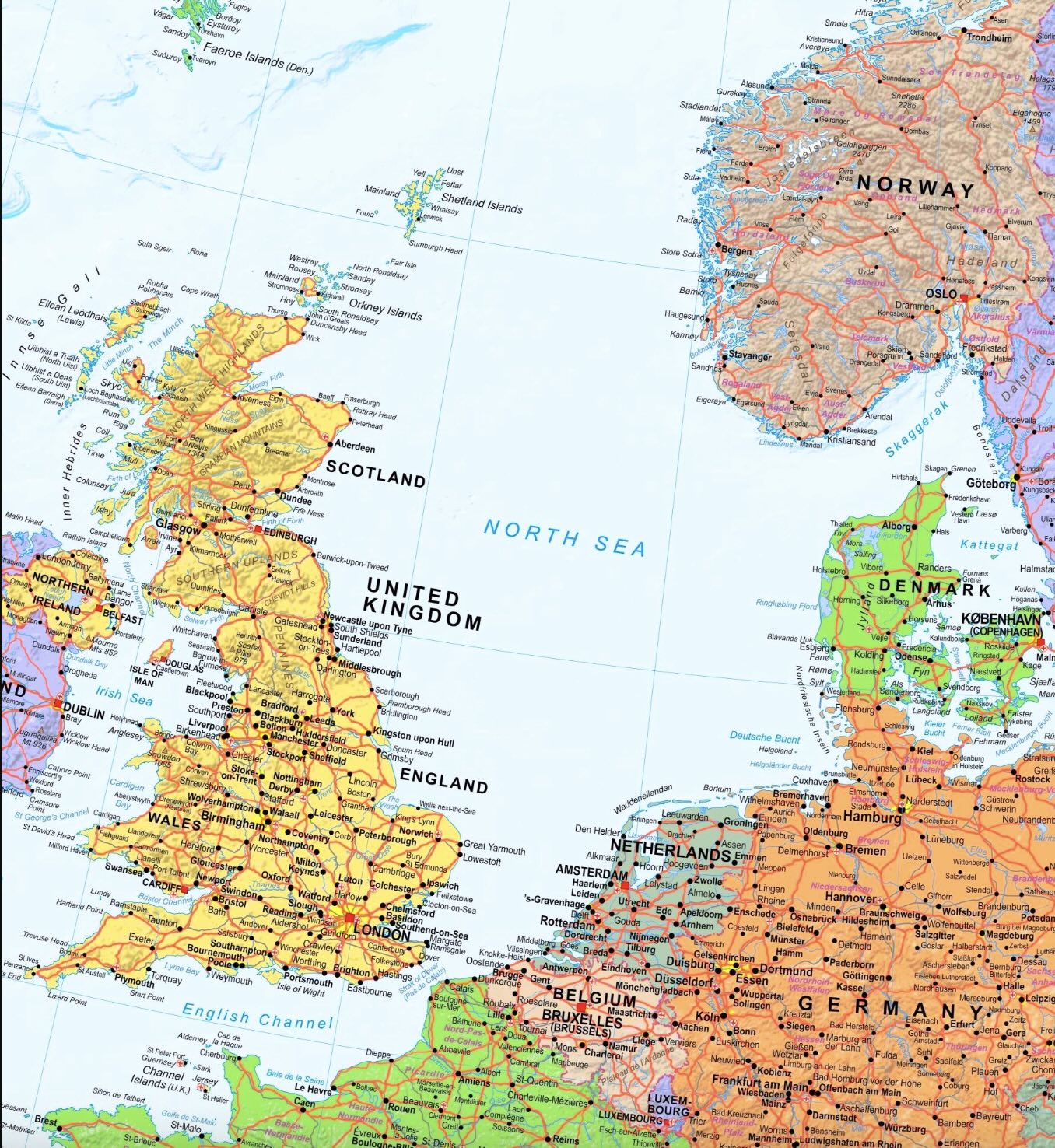
One may wonder why it is called the North Sea. Blame the Dutch for this! The Romans called it, more sensibly, the Oceanus Germanicus (no sea to them!), and England originally adopted this name. The Danes called it the West Sea. But in the Middle Ages, the Dutch had two seas to content with: the big one off the coast, and an in-land sea that had developed and was threatening to swallow much of the country. The in-land one was called the South Sea (‘Zuiderzee’) and the big one became the North Sea.
During Roman times, the Dutch coast line was about where it is nowadays. But the land wasn’t. Rivers fed an inland lake area surrounded by swamps. The coast was protected by sand dunes, formed by sand that came in from the sea. Short rivers connected the lake region to the sea. The river ‘IJ’, the short river on which Amsterdam developed, was one of these. But over time, storm floods attacked the coast. In 1170, the All Saints’ flood created a connection between the lake and the sea, and thus turned the lake into the salty Zuiderzee. Some of the floods became legendary. One of the oldest recorded floods was in December 1287. The floods came early in the morning, before the cocks crowed. Towns near the sea were destroyed and in the north of the Netherlands, reportedly some 50,000 people died. (We should take this number with some caution.) Monks survived better, because they got up for morning prayers well before the chickens, and had time to see the danger coming. The islands of the coast were badly hit. Griend, an island near the mouth of the river Vlie, was much reduced in size and eventually became uninhabitable. In England, Yarmouth was badly damaged.
There was a famous storm flood in 1362, accompanying a hurricane which in England reportedly pulled trees with their roots out of the ground and flattened the church towers of Bury-St-Edmunds and Norwich. The storm became known as the Great Mandrenke (‘men drown’); the flood is called the St Marcellus flood. The flood reportedly destroyed the prosperous German town of Rungholt and killed 3,000 people there. But there are some doubts about this event. Only reports written much later mention the flood – contemporary reports do not. This may be a case where later stories combined different events occuring over decades as a single one. The 1362 St Marcellus flood may have been a mis-remembrance, a fault of history. But if not this flood, then Rungholt was lost in another flood But there were many other devastating floods, which especially during the 13th century altered the Dutch coast line and created both the Zuiderzee and the Waddenzee. The Belgium town of Oostende at that time was on the island of Testerep (at the east end, as the name indicates). But this island was destroyed in the storm of 1394, and Ostende was lost. The town was rebuild on the coast, but kept its name – a phantom of the past. During the Middle Ages, some 250 towns were lost to the sea along the eastern North Sea coast. The most recent storm flood was in 1953 when 2400 people died along the North Sea coasts. And as sea level rises, it will happen again.
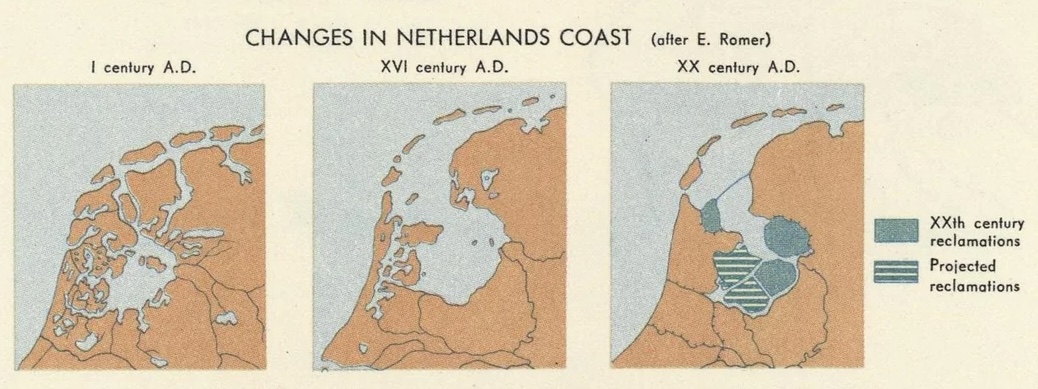
The problem of the Zuiderzee was finally overcome a century ago when a dike turned it back into a lake. Much of it was subsequently turned into polders. (The memory is still recognizable in names such ‘Schiphol’, now an airport in a polder but once a graveyard of sunken ships.) One could imagine that the Dutch would have loved to take the same approach to the entire North Sea and get rid of it. For such a seafaring nation, there is a surprising amount of animosity towards the sea. As one Dutch writer phrased it, the Dutch were shaped by the sea and became it’s opposite.
And I have loved thee, Ocean! and my joy
Of youthful sports was on thy breast to be
Borne like thy bubbles, onward: from a boy
I wantoned with thy breakers—they to me
Were a delight; and if the freshening sea
Made them a terror—’twas a pleasing fear,
For I was as it were a child of thee,
And trusted to thy billows far and near,
And laid my hand upon thy mane—as I do here.
(Lord Byron, Childe Harold’s pilgrimage)
Doggerland
The North Sea wasn’t always a sea. Fishermen would bring back rather non-fishy finds from their nets, such as mammoth tusks and human stone tools, evidence that once this had been dry land.
Much of the North Sea is quite shallow, especially so south of a line that runs from the northern tip of Denmark to Scarborough in England. Along this line lies the Dogger Bank, a sand bank which nowadays is 20-30 meters below sea. (‘Dogger’ was a name for the old trawlers that trawled here for cod.)
During the ice age, sea levels were 100 meter lower and the North Sea was dry land. The modern name for the dry North Sea is Doggerland. It was the size of France, forested and possibly densely (for the time) populated. But the ice melted and the sea level rose, and more and more of the region became submerged. Eventually only the Dogger Bank remained as an island surrounded by the rising sea. A large tsunami around 6150 BCE destroyed most of the island. A part survived for a few more centuries before it too succumbed to the sea and Doggerland became a spectre, a flying Dutchmen of the north.
What happened to the people who lived on the Dogger Bank? We don’t really know. Some may have migrated; many may have died. One wonders whether they ever discussed climate change. Did they notice the sea change, imperceptible over years but destructive over centuries? Did they see their lands diminish? Did they too have arguments around the campfires on whether the danger was real or imagined? Did they sing a song about ‘Dogger Bank ruling the waves’ until they believed it?
The sea is a hungry dog (James Reeves)

Although much of the North Sea is shallow, it does contain two deeper trenches. One is the Norwegian trench, which follows the western coast of Norway, and the second one is the Skagerrak, southeast of Norway. These were below sea level even during the ice ages. In spite of the double name, the two trenches form a single structure. It is not tectonic in origin – no subduction here! (Nor could there be any, in the continental crust of the North Sea.) It is the erosion gulley of an ice glacier which flowed out of the Baltic around Norway into the Atlantic Ocean, and scraped the bedrock to a maximum depth of 700 meter. That was some glacier!
Other than this glacial subsea valley, the North Sea becomes a bit deeper towards the north. Most of the coasts are also low-lying. The main exception is in the north, in the mountains and fjords of Norway create a steep edge to the sea.
Caledonia
The Caledonian Mountains once were a continuous range. They are now divided over Scandinavia, Scotland, Western Ireland, Northeast Greenland and the eastern US, separated by the North Sea and the Atlantic Ocean. Clearly, the sea and ocean are younger than the land. When living on the coast, it seems that the land is temporary and the sea is everlasting. But this isn’t quite true. Continents live forever – oceans die. But there is change and there is resurrection. Continents break up, drift apart, reconnect and join other continents in an everlasting dance of the plates. And extinct oceans can be reborn.
So it happened here. Once, there were the ancient continent of Laurentia in the west and Baltica in the east, separated by the Iapetus ocean. The Caledonian Mountains trace the line where these continents collided and where the Iapetus ocean disappeared. But eventually, the continent that formed from the merger of Laurentia and Baltica broke apart again, in the process forming North America and Europe. In between, the Atlantic Ocean formed – along a line that was almost, but not quite, that of the Caledonian Mountains. Now, one part of the range follows the west coast of northern Europe, whilst the other part lies on the far side, on the east coast of Greenland and in the eastern US.

Supercontinents
There were times when all main continents were joined together. The first supercontinent that we are fairly confident existed is Rodinia, around 1 billion years ago. It broke up into 6 parts. The largest one was Gondwana, consisting of most of the current southern hemisphere plus India. The next largest was Laurentia, in effect modern North America, Greenland and the north of Great Britain. Baltica was (you guessed it) Northern Europe. The others are not part of today’s story: Siberia, Kazakhstania and China. Of course Rodinia itself had formed by assembly; the suture zones where those parts merged are still visible in unexpected and often disconnected places around the world. You can find them in Central Park in New York. The oceans that formed from the break-up of Rodinia include the Iapetus Ocean, surrounding Laurentia.
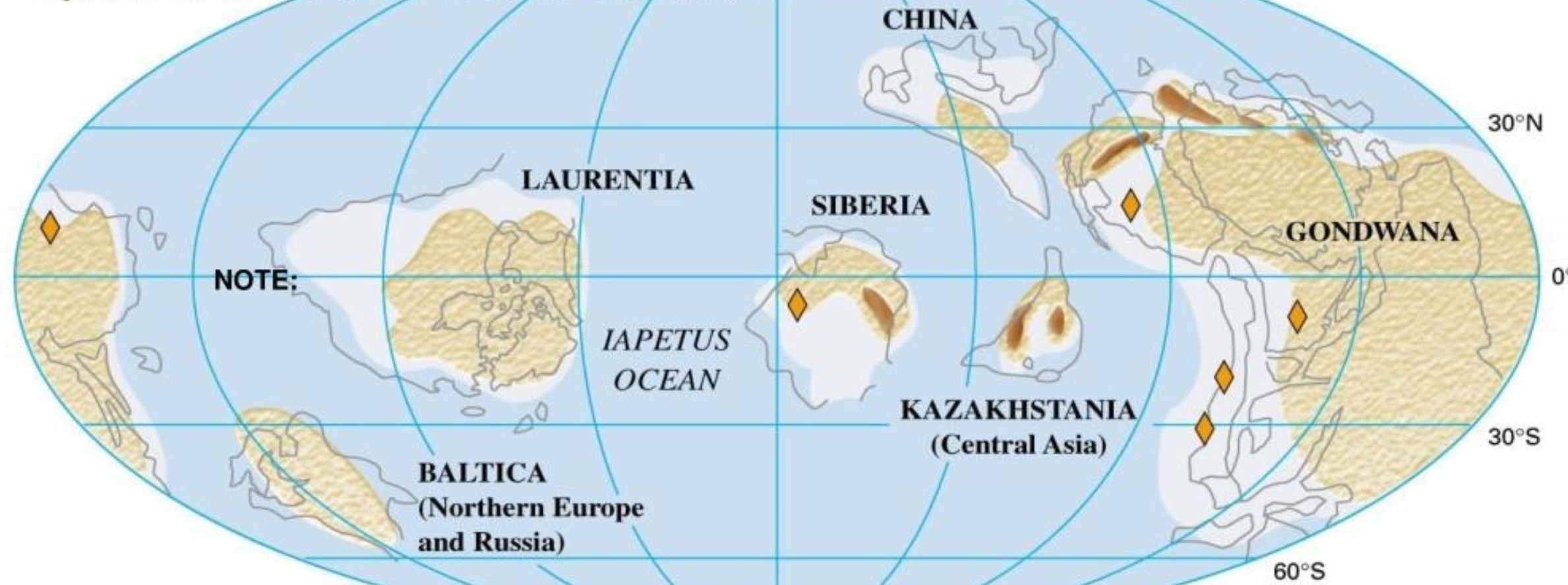
The world after the break-up of Rodinia. This is during the late Cambrian, some 500 million years ago. Be aware that the latitudes are much better known than the longitudes!
At the time, the continents were close to the equator. But Gondwana was on the move and headed south, eventually to become a polar land mass.
After a long time, the Iapetus ocean began to shrink again and Laurentia and Baltica moved closer. But they were being photo-bombed. A continental fragment had rifted off from Gondwana and was rafting across the ocean to join Laurentia and Baltica, closing that ocean in the process. The new ocean behind this fragment became known as the Rheic Ocean. The fragment was Avalonia, and it carried, amongst others, the southern parts of Great Britain, parts of western Europe, most of Newfoundland, and Nova Scotia on the Atlantic coast of Canada. Parts of New England are also from Avalonia. Avalonia docked around 450 million years ago.
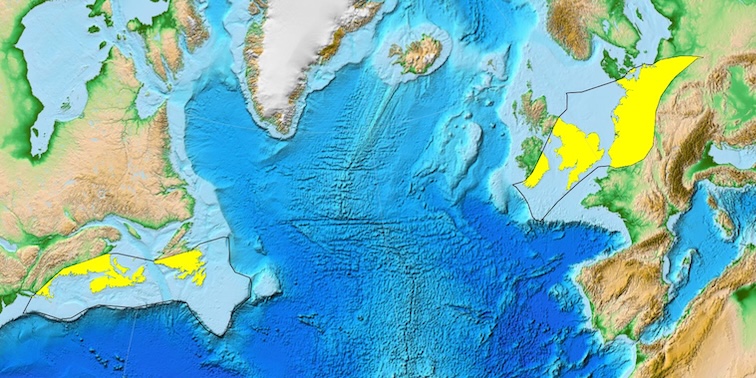
Yellow shows the modern remains of Avalonia. Source: wikipedia
Since Avalonia collided with both Baltica and Laurentia, those two continents must already have been close together. There were not one but three continental collisions in close proximity: Laurentia with Baltica, Avalonia with Baltica and Avalonia with Laurentia. This would form the new continent of Laurasia, around 400 million years ago. In fact, Avalonia was itself not a single entity, but joined Baltica as two separate mini-continents, Avalonia proper and Armorica. This also happened in Laurentia where several other mini-continents joined as part of the same general migration across the ocean. Florida came across as one such block.
The order of the collisions is complex. Basically, East Avalonia joined Baltica 450 million years ago, West Avalonia joined Laurentia some 30 million years later, Laurentia and Baltica joined at around the same time, and Armorica came along around 360 million years ago. There is quite a lot of give or take on the dates: these were not instantaneous events! For instance, the joining of Baltica and Laurentia was scissor-like, starting in the south, and the closing of the scissor took its time.
After all this upheaval the plates were not resting on their laurels. In the east, Kazakhstania would join, forming the Ural mountains, later followed by Siberia. And in the south, Gondwana was waiting. With the closure of the Rheic ocean 300 million years ago, the new supercontinent of Pangea was complete, littered with mountain ranges from all those collisions.
Appalachians

A good example of the complexity is seen in the American Appalachian mountains. These mountains are a combination of several ranges. The oldest range is on the western side and it predates Pangea by a lot. It is the remains of a collision between proto-Laurentia and Amazonia, during the formation of Rodinia. Rodinia later broke up just to the east of this range. When Avalonia joined, it formed another mountain range, east of the older (and by now eroded) one. And finally, the merger with Gondwana formed the biggest range, again just the east. The Appalachians are three-in-one – or even four-in-one, when counting the collision with Baltica wich contributed to the northern ranges of the Appalachian mountains.
Europe
In Europe, the Avalonia collision was a fairly mild one. Not so the collision with Armorica and other parts of Gondwana: these caused mountains to form across Europe, still recognizable in the landscape. Volcanoes erupted across central Europe, especially in the east of Germany. The mountain ranges caused by the collisions do not form a straight line but a series of isolated massifs. They include Cornwall, the Ardennes, the Vosges but also the Massif Central further south. The Czech mountains, which were the prime sites for medieval metal mining, date to this time. The metals were used for making coins, named after their origin in the Saint Joachim’s Valley (Sankt Joachimstaler). The word ‘Joachimstaler’ was adopted for coinage across much of Europe, eventually shortened to ‘Taler’. It became the origin of the word ‘dollar’. And all because of a continental collision: money is made when worlds collide.
The mountain building in the Laurentia-Baltica-Avalonia collision is known as the Caledonian orogeny. As mentioned, the Caledonian mountains are now found in Norway, Shetland, Scotland and Greenland, but also at the northern edge of the Appalachians. But there have been changes over that time. Part of the original mountains appears to have eroded, or collapsed, fairly quickly. The rocks are still those of the ancient hills, but the modern mountains are not: especially the mountains of Norway were uplifted much more recently, in the past 25 million years. Time is not kind to mountains.
By now, much of Europe had taken shape. In the north was Baltica, bordered by the suture with Laurentia, with the Caledonian mountains on the Laurentian side of the suture. The suture runs across the Scottish borders and central Ireland. Further south was Avalonia, stretching from Britain to Poland, with Armorica forming much of Cornwall, the west coast of France and Iberia. And below that and to to the east was the suture with Gondwana (or its many fragments), also with its mountain ranges.
Pangea did not last long. Soon after its completion, it began to deconstruct. This started in its oldest part, Gondwana, as early as 200 million years ago. It was a violent process, involving rifting and volcanic eruptions in a variety of places. Great Britain was affected: the volcanic remnants are found along the western coast of Scotland, in the Lake District of England and in Anglesey in Wales. Eventually, Laurasia was torn apart along a line which approximately followed that of the Caledonian mountains, but lies to west of it across Scandinavia and Scotland and to the east in the part that stretches from Greenland to the Appalachians. Once a suture, always a weakness: the rift zone that formed the Atlantic Ocean roughly followed a line of ancient weakness, but it did cross the (already deeply eroded) mountain range. Curiously, the cross-over was not far from where Iceland is now – which seems accidental as Iceland did not yet exist.

Source: wikipedia
North Sea
Hark, do you hear the sea? – King Lear
The world is a distracting place. This post needs to get back on-topic, the North Sea!
In the north, the North Sea runs between the Caledonian Mountains which formed on the Laurentia plate. Further south, the North Sea is part of Avalonia. The southern edge is close to the border with Armorica. The North Sea is a typical European melting pot of plate fragments – only Baltica is just missing.
The assembling of Europe, during the making of Pangea, set the stage for the formation of the North Sea. But it was a long process, beginning not long after the making of Laurasia but before the joining up of Armorica.
In the region of the future North Sea, the mountains had quickly eroded, and the region was no more than hilly. The first signs of a basin forming are some 370 million years old, when marine limestones formed in the central North Sea, perhaps from some rifting. It was followed by a phase when volcanic debris was mixed in with the sediment. This debris probably came from the volcanism in central Europe, which was caused by the collision with Gondwana/Armorica.
The collision became a drawn-out affair, because Gondwana arrived in a broken-up state. Between 270 and 250 million years ago (we are now in the Permian), new basins formed covering the region of the future North Sea, Germany and Poland. Again volcanoes erupted and left their debris, tuffs and some basalt. Once formed, the interior of Pangea became very dry: the new basin became shallow and partly dried up, first forming lakes and later featuring a featureless land. A large sand desert now stretched across the region. As the continent drifted further north, the land became a bit wetter again.
The new basins were indicative of extension and rifting. This happened along two different axes, one running roughly east-west and one north-south. The two axes crossed in the central North Sea. It is tempting to relate the east-west axis to the growth of the Tethys ocean (actually the Paleo-Tethys, if you want to be precise) to the east. The north-south axis is then assigned to the first stirrings of the formation of Atlantic ocean, with the separation of North Africa and North America around 180 million years ago, although the South Atlantic would form only 40 million years later and the North Atlantic would not take shape for another 100 million years. The rifting basins were deepest east of Aberdeen in Scotland where the sediment (mostly sandstone) reached more than 1.5 km thick.
Some 155 million years ago, during the Jurassic, the rifting intensified and now formed a typical triple-point system, with the central basin in the North Sea as the southern arm, the Viking basin in the northern North Sea as the second arm and the Moray Firth as the third (and less active) arm. The sea returned to the northern and later central North Sea, first as a coastal swamp, later as a sea which would eventually connect to the Tethys ocean which had by now flooded the Denmark basin. From now on, these areas would remain submerged. The oil and gas fields come mainly from marine shales which formed in the Jurassic.
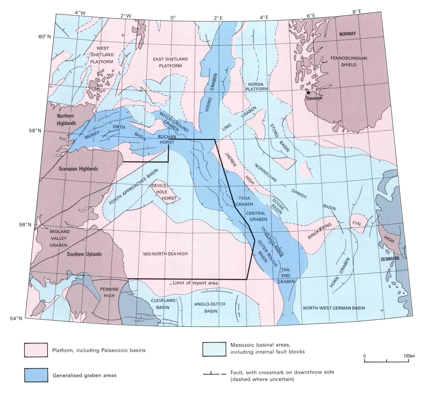
Source: https://webapps.bgs.ac.uk/Memoirs/docs/B01846.html
But there was more going on. Around 170 million years ago, an unexpected event occurred underneath the North Sea sand desert. The ground began to rise and a large dome formed. Evidence for doming has been found in Denmark, southern Sweden and east Greenland. All of these regions were close together, and a possible interpretation is a hot spot or even a minor mantle plume.
Off the Scottish coast, there is evidence for extensive volcanism which extended into the Moray Firth. The rocks have been dated to 155 million years ago, putting it at the time when the Moray Firth triple point formed. It is called the ‘Forties Volcanics’ and covers some 12,000 km2. This has led to a model where a mantle plume caused uplift and volcanism, and later initiated rifting. As the heat withdrew, the dome collapsed and the rifts worked their way towards the centre. Other models have the rifting first and the doming caused by heat pulled in by the rift. Chicken or egg – pick your preference!
The doming region became submerged again by 150 million years ago. The northern North Sea was now sea and the central North Sea was a coastal lagoon which slowly became submerged. The oxygen level was low: the sea was poorly connected to other bodies of water. This was in effect a distant arm of the Tethys Ocean, connected through the Baltic; this connection to the Tethys was often lost. The multiple continental fragments which crossed the Tethys to dock with Asia did not help.
As the Jurassic gave way to the Cretaceous, sea levels rose and the North Sea was flushed out by oxygenated waters. Scotland and Norway remained above water, but otherwise the entire North Sea and its coastal areas were submerged below as much as 500 meters of tropical sea. Chalk was deposited in thick layers. Further south, this sea had arrived earlier: here lies the origin of the Jurassic coast with we have covered in another post. The North Sea had thus far escaped. No longer.
But now the world changed again. The old continents of America and Baltica, supplemented by the more recent arrivals, began to split, along a line which ignored the North Sea rifts. The Chicxulub asteroid came and signalled the end to a way of life. The fossil record of dinosaurs in Europe used to be limited, and there were discussions whether perhaps they had died out before the impact. But fossils found in southern Europe indicate that the dinosaur diversity remained high in Europe’s archipelago right until the end, in spite of any environmental changes. But distance from the impact did not mean survival: we now know that much of the dying came from the heat radiation as debris from the impact re-entered the atmosphere across the entire world. It was death by sunburn.
After the Cretaceous came the Tertiary Paleogene. It was a time of consolidation. Sea levels rose and fell and sometimes the sea was deep, sometimes less so. The land too rose and fell. The Shetland-Hebrides region rose above sea level. Around that time the opening of the Atlantic Ocean reached this region, with volcanic action. The north of the North Sea widened. Once Greenland separated from Svalbard, around 30 million years ago, cold arctic water spread south. Water temperatures at the bottom of the North Sea dropped by 12C and warm-water fish disappeared. The Norwegian mountains were beginning to uplift some 20 million years ago. Sedimentation increased and the North Sea shallowed. And 2.5 million years ago, the climate became colder and the decline into glacial conditions started, although this would not be fully reached for another 1.5 million years. Over that time, much of the North Sea became a vast delta, a mega-Netherlands, periodically being submerged as the sea rose and fell. During glaciations, the sea was a sandy tundra.
During one of the deepest glacial periods, disaster struck. Up to this point, the North Sea had been mainly a gulf, terminating in the south at a chalk ridge. That ridge was part of a massif that runs from London to the Belgium-German border, in the old heart of Avalonia. But now a glacier had cut off the northern exit of the North Sea, leaving the glacial melt water with nowhere to go. Sea level rose and rose, finally reaching 100 meters above current level. At that point, it could overflow the chalk ridge. Chalk is not much resistant to flowing water: the ridge eroded and failed, and the North Sea suddenly emptied towards the south in a tremendous flood. Now, when the glaciers would eventually melt and the sea refilled, the barrier was gone and finally the North Sea became open at both ends. Great Britain became an island.
That is the story of the North Sea. But wasn’t there a volcano?
Zuidwal Volcano
In 1970, an oil company began with exploratory drilling in the Waddenzee southeast of the island of Vlieland, in an environmentally rather sensitive region which had been (and is again) out of bounds for oil and gas extraction. They found gas, and extraction started (carefully) in 1988 (and ended in 2021). But below the reservoir, at a depth of 2 kilometers, the seismographic reflection show the tip of a 1km-tall dome. Drilling revealed volcanic rock. It became the first actual volcano discovered in the Netherlands.
Volcanic (magmatic) rocks are known from various locations in the Netherlands, but those are intrusive rocks which did not erupt on the surface. They mostly date to the time of the Caledonian mountains. The Zuidwal volcano is different: it erupted real lava, and the lava is only 152 million years old. In spite of its considerable age, the volcano remains some 30C warmer than the surrounding rock. The Dutch being Dutch, plans were made to tap the ancient volcano for geothermal heat.
The drilling found a volcanic neck, part of the dome-like structure. The lava was trachyte-phonolite in composition, and came from a shallow magma chamber which had been filled with a mafic mantle magma.
In 1985, similar drilling 100 km to the north in the North Sea found another volcano. The existence of this volcano had already been suspected from a magnetism survey. It had been active at a similar time as Zuidwal, and had erupted a basaltic-andesitic lava. This volcano was named Mulciber, another name for the god Vulcan. Now the Netherlands had two volcanoes!
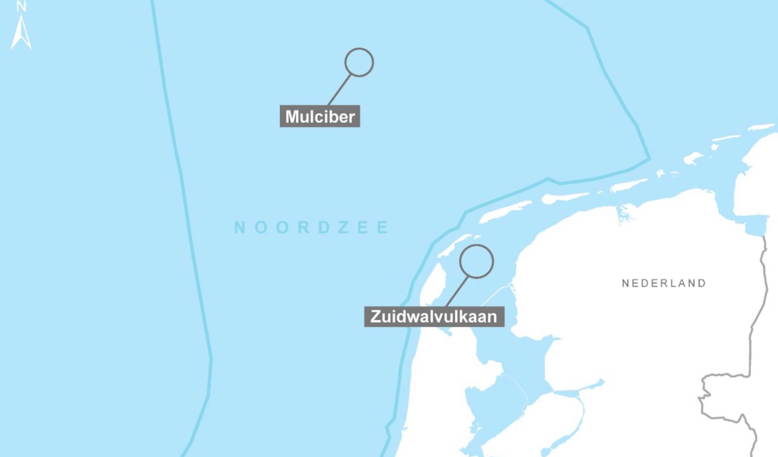
The age of these two volcanoes is similar to that of the doming in the central North Sea and the volcanics at the triple junction off the Moray Firth. They are likely associated with that phase of the formation of the North Sea. They are individual systems and not just dike extensions of a distant central volcano. But the line between them points at the triple point. Gravity highs and magnetic anomalies suggests there may be more volcanic remnants along that line, not far from Mulciber. This activity was all part of the rifting in the North Sea. This was the time when the Tethys Ocean reached into western Europe and when the Atlantic ocean first began to form. In the North Sea, everything is connected.
People of the volcano

The island of Griend
Nowadays, Zuidwal volcano lies in the Waddenzee. During Roman time, this was still mostly land. The island of Vlieland is named after the old river Vlie, which no longer exist – it was swallowed by the sea in the storms of the 13th century. The nearest island is Griend (or Gryn), also already mentioned. In the 12th century, it was home to a walled town (Stedeke Grint), with two churches, a grange (lodge) from the White Canons order and perhaps 50 houses. The town was devastated, and the island much reduced in size, in the storm flood of 1287. Over time the remaining island has migrated 3 kilometres east. A few farmers continued to live here after the town had been destroyed, but the island became abandoned in the 19th century. It is now inhabited only by birds, including the largest colony of Sandwich terns in Western Europe. Only the sea hikers (‘waddenlopers’) come here, although they are not allowed to set foot on the island itself. Do they know what lies beneath?
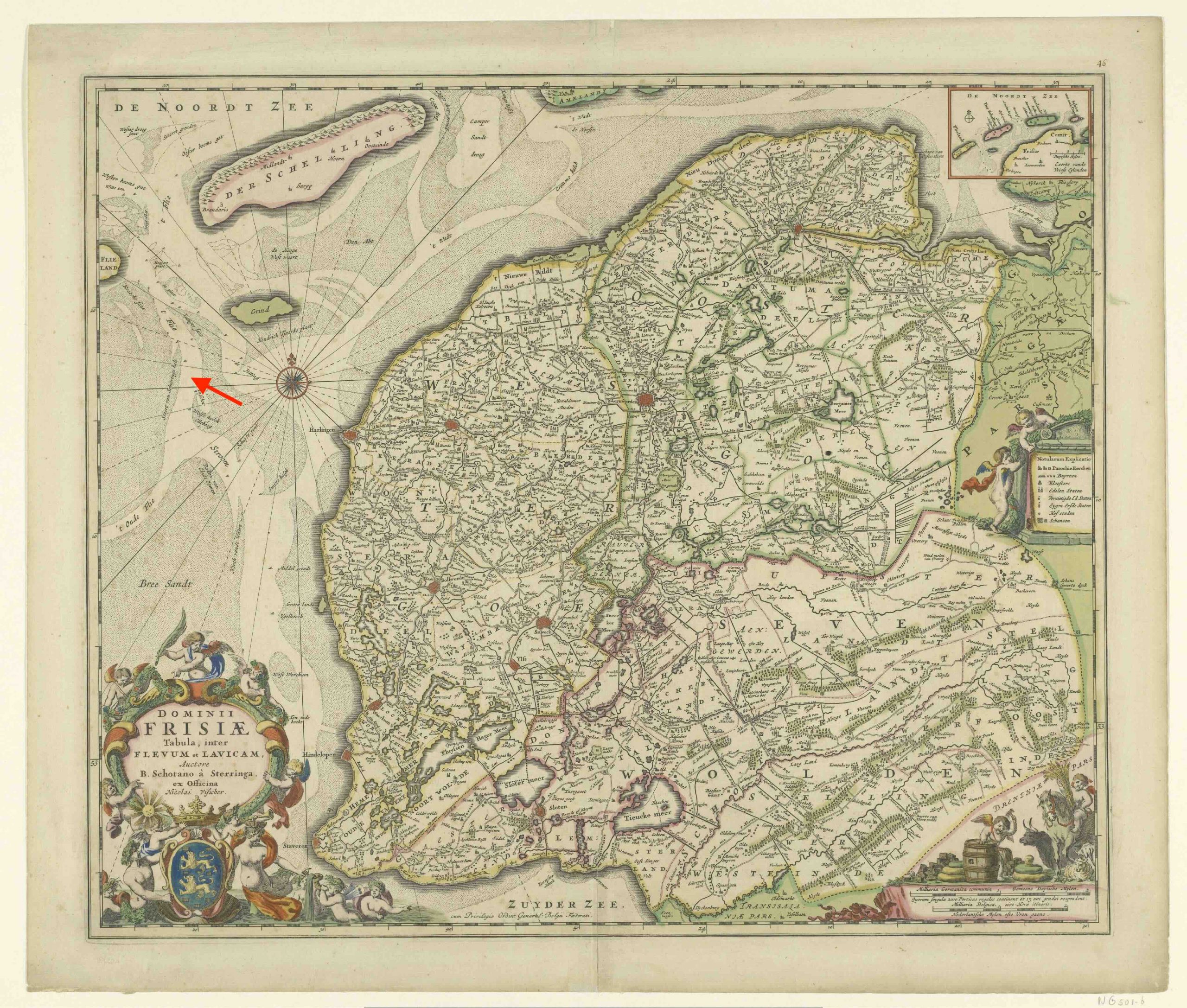
Map from around 1680 made by Bernardus Schotanus. Griend is the green island, still much larger that it is now. The arrow indicates the location of Zuidwal, within the remains of the river Vlie (written ‘Flie’ on the map).
The Zuidwal volcano that is buried here has seen it all. It was part of the origin of the North Sea, a sea that divided mountains but failed to become an ocean. It has seen the sea come and go, seen massive floods and lived through major withdrawals. And now it is part of the Waddenzee, an intertidal wetland with a fluent coast where the sea still comes and goes twice a day. Every day here is like a million years.
All lives and deaths, all of the past, present, future,
This vast similitude spans them, and always has spann’d,
And shall forever span them and compactly hold and enclose them.
(Walt Whitman, On the Beach at Night Alone)
Albert, September 2025


Thanks Albert for a fascinating exploration of the North Sea! I’ll add that it once was a jungle, since as well as the oil and gas reserves there are very large coal deposits there too – trillions of tonnes.
The volcanics of Cornwall would be interesting. I’ve never looked it up. Cornwall though features with great importance in European history as a rare source of tin, which was essential to the Bronze Age. The Phoenicians sailed to Cornwall perhaps even 4,000 years ago to get it. My impression is that tin is often contained in carbonatite and pegmatite magmas, so it’d be interesting to know if those occur there, and whether they are related to the geology of Avalonia.
Trust a person from Newcastle to bring up the coal. It is quite a bit older than the oil and gas and predates the North Sea. As the name suggests, it goes back to the Carboniferous. Think 300 million years ago
For Cornwall, there is some information in https://www.volcanocafe.org/ghosts-of-christmas-past/
It’s Sunday night here in the antipodes, so I have been taking in your 2020 essay, which I somehow missed. I’ve been visiting VC for a long time, so how I missed it is a mystery. Maybe it was the hurly burly of Christmas.
Once as a kid I was riding my bicycle near Herons Creek (extra brownie points if you know where that is), On the dirt road was a fossil, an ammonite. Only an inch in size, but it was sheared and I could see its innards, which were opalised. Like a garden snail, in quartz. Quite beautiful. I don’t have it any more, but it was a memorable find fifty years past. In the distance was towering Middle Brother, a volcano from 212 My ago. I think the ammonite predated the volcano, but I have no way of knowing that.
Just west of my old high school in nearby Wauchope is a limestone quarry. Again as a kid our dad took us there to check it out once. Amazing place, the limestone was entirely comprised of crinoids. Fascinating and wonderful. That was also fifty years ago, so I don’t know if it is still there.
Mary Anning sounds like a babe. VC people should read Albert’s marvelous 2020 article if they haven’t already.
https://www.jstage.jst.go.jp/article/vsj/2012/0/2012_95/_article/-char/ja/
https://www.jstage.jst.go.jp/article/vsj/2023/0/2023_198/_article/-char/ja/
Google sucks
Second one was a waste of time. Chrome mobile app sucks.
Kilauea showing a bit of a different trend now compared to earlier. UWD is showing the typical declining curve as pressure increases and acts against the magma flow. But SDH is a linear up. E32 had significant extra deflation at SDH compared to E31, but SDH behaved perfectly as expected.
So it looks like now the eruption might be originating at, and more controlled by, the primary magma chamber and not the one that is under Halemaumau, and collapsed in 2018. That is, its got way more magma involved. Episodes might stsrt getting huge and more widely spaced,or something is about to break…
Albert, Hector, Tallis, Jesper, & Tomas,
Please forgive me if I missed anyone that has wrote an article in the last couple of years…but I don’t thank you for All Y’all’s articles. Usually I spend too much time going down the proverbial rabbit hole leading into the dike within the caldera of the volcano for each article wrote by each one of you.
Normally the ESC tiltmeter spikes North at the start of each episode and then decays until the next episode. After Episode 32, the ESC seems to have stabilized to the North before decaying much more slowly out front of Episode 33. It also shows strong movement to the West during an eruption, with slow movement back to the east during recovery. It maintained this pattern over the last 3 Episodes.
In my Non-Vulcanologist read of the ESC, it appears to show further evidence of broader inflation over the whole summit to the North rather than in and out of just the Halemaumau chanber. This adds value to Chad’s argument above. I welcome thoughts…
No need to ask for forgiveness.
There is definitely pressure building.
Right now most summit quake activity seems to be right at the vents, so E33 could be expected to involve more vents, or the existing vents might adjust in which one is the strongest.
I dont know where HVO are seeing a decline in inflation sufficient to delay E33 by multiple days, both tiltmeters have been basically dead straight up since E32 ended.
https://www.jstage.jst.go.jp/article/jgeography1889/94/6/94_6_464/_article
https://kaken.nii.ac.jp/file/KAKENHI-PROJECT-21510193/21510193seika.pdf
Most Convoluted setup for a volcano, I’ve ever researched. Somehow there is more study but less information on Ioto than CCN. What load of bull$# ?resize=1024%2C580&ssl=1
An eruption there would likely follow a difference sequence than the 1919-1920 and 1823 eruptions (northern SWRZ). Just imagine that a volume of an episode enters a basaltic-andesitic magma chamber of one cone in the southern SWRZ. A voluminous intrusion like this would likely cause a fast dynamic Strombolian to Hawaiian eruption with bombs, tephra and a’a lava flows.
2023 Hector assumed that magma had accumulated 1981 below the southern SWRZ. He embedded this map in his essay:
We should try to distinguish what part of SWRZ is involved in the new earthquakes.
In a study about the Kamakaia eruption they write “the progressively more mafic magma that continued to erupt throughout the waning stages of activity suggests an eruptive triggering process whereby an intruding summit or uprift reservoir basalt overpressurized and forced out the stored, differentiated magma of the Kamakaiʻa Hills rift zone reservoir.” https://www.sciencedirect.com/science/article/abs/pii/S037702732300224X (cited from Abstract)
Can we imagine how the intrusion would develop? Where would it originate? Where would it run until it hits the Kamakai’a basaltic andesite chambers?
Kilauea’s next episode may come before the weekend, if past trends continue
Since 12th September Iki tilt has inflated steeper than before and than UWD, SDH:
Maybe the next episode is going to jump to a more eastern location inside the caldera between Halema’uma’u and Kilauea Iki.
Apparently, Ioto is erupting again today (nothing on the news yet that I’ve seen):
https://www.data.jma.go.jp/vois/data/obs/kansoku/open-data.php?id=329#longdata
Any idea where this eruption happened? All of this coinciding with some extraordinary uplift is not rubbing me right. If this eruption is a continuation of the one from earlier this month. Then it may not be too bad.
Smallest uplift rate observed is 1 cm/ day so far.
I don’t know.
Getting to angry write but aren’t multiple sources of deformation on the insar or just my imagination?
As foolish as this might sound, have you thought about trying to directly contact any of the agencies responsible for overseeing Ioto’s activity to see if there’s more info that could be shared that hasn’t already been shared?
The west and south sides of the dome have a lot of slip along faults, creating a complex and hard, if not impossible to read, mosaic of deformation
I’m assuming based on your other comments, the activity (eruptions or any other substantial activity) at those faults has increased?
Not a bad idea but I am unaware of their contact information.
There’s an InSAR of the recent crisis. The northern part of Ioto seems to have uplifted considerably, over 20 cm, not sure how much exactly. The southern side has seen several cracks form running from Suribachiyama in two branches towards the new vent on the west side and the 2023-2025 vent on the SE side. Radar views of the new crater are also available:
https://www.gsi.go.jp/uchusokuchi/20250910ioto-e.html
Actually, >30 cm of uplift now that I look at it carefully.
I’ll have to do a rewrite no way this doesn’t get article.
What a load, the way this volcano has been handled.
The scale of deformation, extensive fracturing around the center of the resurgent dome, and likely magmatic eruption from both sides (near the cracks) are, taken altogether, a little… concerning.
This a bit more than a little concerning. According to GPS data suggests that the fastest uplift is near the current vent.
Either the magma chamber is experiencing a preposterous intrusion, it is sending even more magma to the sill(so much so it’s compromising the crust) or the plug is starting to fail.
“According to GPS data suggests that the fastest uplift is near the current vent.”
According to InSAR the central uplift seems over the north part of Motoyama* near the center of the caldera. The eruption is near some of the ground ruptures. On the other fracture side, increased steaming areas have also apparently been reported. The cracks have slipped but are not new; they show in geologic maps.
*Edit: Having translated the legend, it turns out I was reading it upside down.
Damn it. It looks even worse. Read the August report, it states that the fastest uplift is at Chidoghara. 3 cm/day. Those cracks and fastest inflation is along the Asodai fault. Not good.
https://www.data.jma.go.jp/vois/data/report/monthly_v-act_doc/monthly_vact_vol.php?id=329
Hector, do you think this uplift related to the magma chamber or sill. It is extremely hard for me to believe that is from the reservoir but the sill is only 4-5 km wide and the uplift covers the whole island and it looks a significant portion of it is still underwater.
Simply put it looks to expansive to be the sill.
The radius of the uplift is at least 6-7 km…
Magma chamber, I think, it affects the whole caldera. Bw, I sent you a message related to this.
At about 10am 14/09 a plume can be seen drifting westward, similar location to the last phreatic explosion on the west/south-west side of the island. Not too far from some buildings. It’s sustained until about 3pm.
Has the island been evacuated?
Nah, still waiting on an official report.
Temblor (Ross Stein, et al) has released an informative article on the Kamchatka M8.8 quake, and especially focusing on whether or not the foreshocks (M7.4, M7.2) could have been identified as such, thus providing some warning that another megathrust event was about to happen.
According to the article, given the close proximity of the M8.8 and the ~M9.0 in 1952 in almost the same locale with much overlap a certainty, there is reason (but not proof) that we now have data spanning an entire mega-thrust cycle spanning the two main events. When the foreshocks and other activity were analyzed, sadly there was nothing definitive as far as trends outside of “normal” behavior both preceding and following the foreshocks, with the aftershocks following traditional patterns So, like Parkfield, there were no obvious signs that could have been used to issue warnings or even advisories…since less than 1% of M7+ quakes are followed by much larger events (however the converse is ~90% of mega-thrust quakes had foreshocks beforehand).
So for now, earthquake prediction remains just a distant dream.
https://temblor.net/earthquake-insights/huge-july-2025-kamchatka-earthquake-follows-unusually-productive-foreshock-sequence-16866/
To which my response would be ‘Fine. Great. We have observed one ‘cycle’ – now we need to observe another ten cycles to start to build a picture of how regular they are (or aren’t)!’
With this latest swing-and-a-miss at finding some type of “reliable” mega-quake precursor signal,
(such as foreshock patterns/behavior), another 10 cycles would likely yield nothing new.
But…we do have a benchmark now (sorta).
What we know is for a subducting fault/plate with a collision rate of 83mm/yr, it can take “as little as” 75yrs for the same section of fault to go from fully relaxed to breaking point on a mega-scale…which I think is a valuable data point. A now-proven 75yrs is a much shorter repose period than any other fault that I know of that’s prone to mega-thrust faulting…(so Parkfield is not included). For other mega-faults, repose periods typically range from 150 to 1000 yrs depending on local variables.
It wasn’t a strict repeat of 75 years ago. It never is. There were several segments involved, probably with different slip, and the previous event may not have resolved all the pent-up stress everywhere. The stress transfer at the edges of the quake may also have been different. I wouldn’t take this as a schedule with the next appointment in 75 years. The fact that the foreshocks cannot yet be recognised as such is an important point, though.
An aside…I hope you can get a nice boat trip to Raoul Is, to fix the web cam. One of the most remote volcanoes on the planet!
Out of curiosity, do we have any good up-to-date models on potential tsunami risk of Iwo Jima in the event of a caldera formation event? I thought I had seen that some of the initial estimates on tsunami risk in earlier Iwo Jima posts at Volcanocafe were somewhat overestimated due to not modeling the tsunami as a point source?
Nah, we ain’t got any good models as far as I know. it’d probably be bigger than the Tonga Tsunami but by how much is up in the air.
This was a bit “discussed” in 2015 at this site. Hypothetical, but it is interesting to see how things develop, as well as the lack of progress of our knowledge it seems on this volcano. https://www.volcanocafe.org/the-new-decade-volcano-program-no-1-ioto-japan/
Yeah I was aware of that, but in that 2015 post, I believe Henrik’s “back of the napkin” modeling of a tsunami wave was possibly a bit off, leading to a larger estimate of a tsunami than what would likely occur the further you get from the point source. Tsunamis that originate from a single-point source such as a landslide or caldera collapse would assuming equal displacement begin much stronger than a megathrust earthquake, but dissipate quicker due to the energy spreading radially.
I believe the original 2015 post assumes that there was in fact a caldera eruption from Kuwae in 1458 (which is still debated) and that it also caused the large paleotsunami deposit found in New Zealand. I don’t think this is something that has been confirmed, and there are many doubts.
All that being said, the net displacement in the event of a caldera formation at Iwo Jima would likely be significantly larger than what we saw in even the Indonesian Boxing Day Tsunami, which saw around 30 cubic KM of water displaced during the megathrust quake that occurred there. A 10×8 caldera collapse for instance would probably displace around 80 cubic KM of water.
I used some ChatGPT calculations assuming a point-source tsunami model and got a lot of different #’s, because I’m fairly unsure of the inputs for the variable “mean initial surface elevation” in this model. I believe the point-source model being used in this instance is more specifically designed around traditional landslide events, not caldera formation events. But since the caldera depth I am assuming here is 1km, I just went with that, which would give a 50m tsunami height at a distance of 2000km away (distance to Shanghai). I do not think that’s reliable, and probably assumes a worst-case scenario anyway, but clearly there are a lot of unknowns here.
Its worth noting the islands near Hunga Tonga were protected by coral reefs and stuff further away was much further away from Hunga Tonga than East Asia is from Iwo Jima. That article probably rather overstated it, but just scaling up Hunga Tonga to more Krakatoa-scale would not be pretty. Japan would get the highest tsunamis but they are pretty experienced with major tsunamis. Wouldn’t be surprised if the worst would be in China. Most of Shanghai is less than 5 meters above sea level…
I really doubt proper planning has happened or will happen. China has a decent bit of state capacity, but as we saw with Covid that requires them first to accept there is a problem. We probably do have some notice, escalating trends generally don’t happen overnight for VEI 6/7 systems, eg Krakatoa or Hunga Tonga, often some trending up the escalation pattern before their big bang, often reaching a magnitude or so smaller than the final thing. So Iwo Jima may well do a VEI 5 before its ready for a grand finale. Of course whether that is used…
But yeah, Iwo Jima is definitely the very much the most obvious candidate for next VEI 6 or 7. The hyper-inflation of recent years is clearly pushing against the strain rating of its ceiling and if it doesn’t slow down soon… That’s of course assuming that the acceleration in inflation is not itself a sign the system has become destabilized.
I would think there are too many variables. If some of the island slides west it might all blast that way and send a 30 meter wave to the coast of Asia. But it might do that east too and do nothing much. It might also be shallow enough that the actual explosion isnt really in water, and waves are from he flows entering the ocean after. Which of those is worse maybe isnt really well studied.
My guess is it still probably isnt going to be as bad as a thrust fault tsunami as it is a point source but much beyond that probably has too many variables to be more accurate until it happens.
Point source tsunamis actually start out stronger, but dissipate quicker. So probably better if you are far away, but far worse if you are within a certain radius. Also, collapse tsunamis from either landslides or caldera collapses have the potential to displace far larger volumes of water than megathrust tsunamis. Taking the original Iwo Jima caldera, the displacement from it’s formation would assume a volume that would probably be around 3x larger than the 2004 Indonesian boxing day tsunami.
And to your point, it all gets even more convoluted if there is some directional component in the event of a landslide.
There is a bit of a difference though, a megathrust quake directly shoves the ocean up over a huge area, the caldera is focused and not necessarily deep underwater enough for the ocean to flow in fast enough.
Basically the caldera collapse could be much less efficient than an earthquake if it is actually the creation of the caldera itself that makes the waves. If its the ignimbrite flowing into the ocean down the flanks then its basically the same as a landslide though, maybe a bit less forceful if there is a kind of leidenfrost effect but I dont know if that is a thing.
It wasn’t a strict repeat of 75 years ago. It never is. There were several segments involved, probably with different slip, and the previous event may not have resolved all the pent-up stress everywhere. The stress transfer at the edges of the quake may also have been different. I wouldn’t take this as a schedule with the next appointment in 75 years. The fact that the foreshocks cannot yet be recognised as such is an important point, though.
NASA just published a nice InSAR map of Kamchatka earthquake with red colours indicating movement to the East and down:
The InSAR data also highlighted displacement at the Krasheninnikova volcano, which erupted just days after the earthquake:
The full article is available here:
https://earthobservatory.nasa.gov/images/154776/mapping-kamchatka-earthquake-displacement
This might be a reply to the wrong comment Albert 🙂
Not sure how that happened. Comments can’t be moved, so re-commented
Ioto had 11 more episodes today…
Episodes of what? By this point, Ioto might as well be ramping up to something and I worry it isn’t good news…
Current eruption has fluctuating intensity, 11 more episodes of higher intensity.
11 episodes of magmatic eruptions? and are they at multiple locations? or in the same general area?
Same location
Image from the latest sight. The activity was so bad the military had to practice elsewhere.
https://www.stripes.com/branches/navy/2025-09-15/iwo-jima-volcano-navy-practice-19095661.html
“Attention men, the west beach is occupied today. We’ll be carrying out the Resolute Dragon at 0800, 200 yards further up the hill.”
Quite ironic. What used to be an important battle between two nations has become a important battle between man and a volcano. It’s not if the island is going to be wiped off the map, but when that’ll happen…
I would personally not want to be there. It might not be very soldierly (?) but I’d fake an emergency back home. Imagine being stuck on a tiny island and it starts rumbling and erupting right next to you not a mile away.
The increasing seismicity at Kilauea’s summit is interesting. I wonder what this means for the next episode of fountaining.
It might just be a sign the vents are true conduits now, and behave the same as the rift connectors just vertical instead. But it also could be a sign that E33 will have a satellite vent, or a change in which one of the primary vents is dominant.
Either way we will see in a few days 🙂
The summit recovered from a small DI event. (Visible only on UWE, not SDH). The rumbling was during the recovery, so perhaps caused by the change in pressure.
Seismometers have been relatively quiet over yonder up top Big Sis, but I noticed a 2.55 Magnitude quake 2 km above sea level about halfway up to the Mauna Loa’s summit on the Northwest flank. Its been a long time since I have seen one that big considering how inflation has ramped up over the last 6 months as Chad has pointed out. I’d assume that a run up of Earthquakes would need to occur before we could predict when the next eruption might occur. I would bet there is a VolcanoCafe article around here somewhere that might provide some intel in the lead up to the 2022 eruption to see how far we’re out! Would this classify as a Volcanic/Tectonic quake as our Big Gal adjusts to the extra kilograms she’s putting on around the midsection?
Latest eruption during day.
During night.
From: https://www.volcanodiscovery.com/iwo-jima/news/280213/Iwo-jima-volcano-Volcano-Islands-Japan-new-phreatomagmatic-eruption-new-crater-is-forming.html
To note, those were taken on the 3rd of this month and the brightness, as Hector mentioned, means fresh magma, not just blown bits. Also to mention too, as Tallis said, more episodes did happen since then. This could be a worrying sign…
(Also, unrelated, would like to know if these webcams are public, and if that is the case, where could I find it?)
Zach, I am trying to chase this down, but ending up in some dead ends. The best that I have so far is https://news.yahoo.co.jp/articles/d00257d555033112b0971a3c7a70af19c206d398/images/000 where the JMA is discussing it, but some of the websites keeping track of volcanic activity on Ioto have NOT been updated and one website even said “no volcanic eruption last 2 weeks” which from today is not correct. I tried digging into JMA to take a look but haven’t come across anything in regard to webcams. I do know from my reading about Ioto recently that people allowed on Ioto is watched very carefully, so you don’t get the public exposure which you wish, as found on the other volcanic islands near or at Japan. This is a USA doing, not Japan.
Interesting study about the Santorini unrest earlier this year. There was magma involved. https://news.uoregon.edu/study-finds-magma-helped-drive-recent-santorini-earthquakes
Iceland:
“Approximately 8–9 million cubic meters of magma have accumulated beneath Svartsengi since the last eruption.
The likelihood of a new event increases when around 11 million cubic meters have accumulated, expected towards the end of September. However, there remains considerable uncertainty.”
https://en.vedur.is/about-imo/news/earthquake-in-brennisteinsfjoll-faster-subsidence-in-krysuvik-and-continued-magma-accumulation-at-svartsengi
The second episode of the 1b eruption cycle is likely going to be approached sooner or later in fall 2025.
Yeah, 10M m^3 sounds a lot, and it is, but its 0.01 km^3…
That I have a handle on. Its 1 sq km 10mm deep.
news/earthquake-in-brennisteinsfjoll-faster-subsidence-in-krysuvik-and-continued-magma-accumulation-at-svartsengi
The interesting first parts mentioned in the link remains unpublished? That (krysuvik) concerns the activity near Kleivatn I think.
Can we estimate how much the failed microplate of UK moved west during the North Sea rifting?
The North Sea is an interesting area for linguistic/philology. It’s interesting to follow the gradual divergents and unions of languages all around the “Oceanus Germanicus”. F.e. the West Germanic (German to English) and North Germanic (Skandinavian) languages once diverted from each other, but later influenced each other again and converged again a bit. English got Norse words, Skandinavians got modern English words. The Hanseatic era added Low German loan words to the Skandinavians that are lost in contemporary High German that substituted the written Low German in Lower Saxony and Lübeck (capital of Hanse confederation).
On the V3 Kilauea camera looks like something gave way in the south vent at around the 3:55:54 timestamp. Before that point the south vent is barely visible, then a bit of glow starting at 3:55:36, and a burst at 3:55:54. Since that time the south vent has been glowing more strongly than the north vent, at least from V3’s point of view. Perhaps an indication that the south vent will be more prominent for the next episode?
I was think so too probably just an overhanging ledge falling in exposing the vent.
Earthquakes concentrate on SW corner/exit of caldera:
With the Iwo Jima eruption ongoing, I could only think of many possibilities, but a few are likely:
1. The eruption just ends, like the rest of the eruptions.
2. Eruption intensifies into something concerning.
3. Eruption continues and builds a cone similar to Suribachiyama.
4. Eruption turns into a different style.
Based on the eruption from 2023 and the GPS data map, I fear that #2 is likely. Even if #1 ends, there is still that risk of a large eruption in the future.
It erupted on the South-east side not a year ago (the new island). It erupted in the north in 2015. The north-west coast in 2001. Tends to favour that west/south-west side (Asodai) though.
A quick look at the eruption history shows that it has done about 15 eruptions off the west/south-west just within the past 100 years. All small VEI1 though, so not sure what that tells other than it’s a weak spot.
Map of all eruption sites, from 1889 to 2022. They form an almost enclosed ring, a possible location for a future ring dike to let loose. The only thing is that there are no eruptions far off the east shoreline. Maybe that’s a strong point?
trapdoor?
Personally, I would doubt that this is due to it being a ring fault type structure where these eruptions occurred. I think most of this follows where you would naturally expect potential phreatic eruptions to occur, which would mostly happen close to the coastline. There likely would have been other subaquatic phreatic eruptions that went unnoticed offshore. Also note that the northern end of this supposed structure would not be well defined.
If it were a ring fault, you would generally assume that inflation would not be occurring outside the boundaries of your proposed ring fault, but that’s not the case here. The whole area has been uplifting in a dome-type fashion, extending far beyond what would be implied if the historical source of phreatic eruptions did represent a ring fault structure.
Yes I also think it’s too small for a ring fault given the inflation radius, also Suribachi in the bottom left corner erupted at some point prior to 1889 and created a cone. It’s an uplifted dome with several weak points, or perhaps it is just uplifting too quickly and not erupting enough to build some sort of solid cap. Most of it’s eruptions are trachyandesites which with the addition of water means mild explosivity rather than any form of dome building.
Is it possible that represents the edge of the sill underlying Iwo Jima which is thought to be about 4-5km wide? Basically the sill leaking out at its edges…
The area of inflation is much wider of course but that would be the underlying magma chamber. My rough estimate of 20km^3 of inflation since the 800BC eruption is trying to back-estimate the area within the broader ~10km wide structure that looks like a caldera. Given how much Suribachi inflates though, I do wonder if the inflation covers a broader area than even the caldera structure, which of course would add additional inflation…
Very interesting map, Zach. My collection of NASA Firms satellite hotspots on the Island show the most concentration in the northwest zone, near to where the 3 black dots are clustered close to each other at the 280 deg direction.
https://cimss.ssec.wisc.edu/satellite-blog/archives/35120
Old but thats some COLD cloud tops indeed but its not strange at all since tropics haves a very high tropospause 20 kilometers or more and at poles its as low as 7. Hunga Tonga pyroclastic cloud likley had even much colder cloud tops than this being 50 kilometers tall or even more..
The lava lake got really high, but drained back.
Doing a bit more reading / research / digging into the original post by Henrik on Ioto, I really think it would be useful for researchers to get a better idea on the Kuwae eruption in the mid 1450’s (it’s been dated to either 1453 or 1458 inconclusively).
IF Kuwae did in fact cause the tsunami deposit found on Great Barrier island in New Zealand (offshore of Auckland), this implies that any caldera forming eruption of Ioto that is VEI-7 in size does in fact pose very very large risk for enormous metropolitan regions.
Lets start with the assumption that Kuwae did cause that tsunami. The distance between Kuwae and the island where this paleotsunami deposit was found is approximately 2150 KM away. That’s further than Shanghai from Ioto (approximately 2000km) and far more distant than Tokyo from Ioto (approximately 1000km).
https://i.imgur.com/jOtN6CV.jpeg
Furthermore, if you look at the region around Kuwae in Vanuatu, you would notice that in the path of the tsunami as it would point towards Auckland, there are numerous islands that would stand directly in the path of propogation. This would in theory increase the turbulence and cause greater dissipation of the radiating tsunami wave in the region of Auckland. So even with this in mind, the tsunami still saw a 14m run-up (which is just a minimum, not a max limit on the run-up) over 2100 km away.
If you compare this to Ioto, you would probably say that there are fewer barriers (especially directly surrounding the source) that would block wave propagation as the wave heads towards major metro regions. Given, that doesn’t mean there are no barriers or sources of turbulence – the Ryukyu island chain would probably slow wave propagation towards China, and the small islands from the volcanic chain that Ioto sits on would maybe disrupt the wave a little bit to the north. But if the Kuwae eruption did in fact cause the Auckland Paleotsunami, that means that in the event of a similar size eruption (which isn’t an entirely unrealistic scenario), you would be looking at a Tsunami that is possibly over 20m high in Shanghai.
The upper bounds for a tsunami I get for Shanghai implies a 50m high tsunami. Note – this is upper bounds, and any real tsunami would not be this large as the calculation does not account for turbulence and assumes highly efficient transfer of energy. This upper boundary estimate is assuming an 80cubic km caldera depression, which I’m using as an approximation based on the size of the previous Ioto caldera. Obviously it may not be as large, or alternatively, could even be larger (I would say this is less likely however). That being said, even half the size of the upper boundary, which I do not think is unrealistic if Kuwae did in fact cause a 14+meter tsunami in New Zealand would be the largest natural disaster in history.
A VERY rough estimate of population within 1km of the coastline in at-risk regions of the tsunami is around 25-30 million people. Want to emphasize that this is an extremely rough estimate however.
And to add more consideration – the City of Shanghai alone has a metro region population of around 30 million. Given, many live further inland than the estimate of 1km from the coastline in the above post, but Shanghai and many other Chinese coastal cities exist nearly at sea level. The average elevation of the Shanghai region is only around 4-5m above sea level, which would imply that any tsunami of decent size that would hit the region would likely see intense inundation.
Additionally, to add more risk, there are lots of levees and floodwalls in the area, meant largely to control the river and potential storm surges. But these would be breached by a 14km tsunami causing major flooding issues in the region.
Needless to say, we really do not want Ioto to go caldera here. And if it does, it would be really good if it was “just” a vei 6 eruption instead of something larger. While the original NDVP post putting Ioto as the #1 risk on the list is based on some conjecture and assumptions, it’s really hard to argue against this being the #1 risk given even some very realistic scenarios.
I think Kuwae is more likely to have been regionally devastating but less affecting as far out as NZ. The bathymetry isn’t great but there are not so many long-ranging pyroclastic density currents (ridges) extending from Kuwae area.
There have been 6 M8.0+ megathrust quakes within 1500km of this island since 1900.
Several earthquakes have hit NZ quite catastrophically: https://www.odt.co.nz/star-news/star-christchurch/nz-must-heed-warnings-past-tsunamis-researcher
Kermadec-Tonga is 2000km long and theoretically capable of an M9.0 earthquake
I always wondered that, Kermadec trench is very nearly as big as the one off Chile, which is a notorious heavy hitter with a scary track record. But nothing for the Kermadecs. Not to dismiss the volcanic tsunami risk but it seems like it was assumed based on Kuwae being a big caldera in shallow water maybe the right age, that it is Krakatau 10x and so was the culprit. Not the 2000km long subduction zone right north of the sample site. Maybe this is ruled out for a reason, I havent looked, but I havent heard it talked about even on here before either.
Definitely a lot of unknowns, but there has been some strong evidence pointing towards the source being Kuwae. The main culprit being that the tsunami seems to have been contemporaneous with other tsunami deposits in the region, including those around Vanuatu itself which include evidence for the Kuwae eruption within them.
https://meetingorganizer.copernicus.org/EGU2011/EGU2011-85.pdf
I think it’s getting a bit closer to established that Kuwae was in fact the 1450’s mystery eruption culprit. Magma signatures have been found that geochemically match. See here – https://meetingorganizer.copernicus.org/EGU25/EGU25-2329.html . Not initially finding the pyroclastic density currents could be due to a wide range of factors. But we know as of now:
– That this was in fact a very large eruption that occurred that created a caldera in the 1450’s.
– The caldera collapse was not gradual or piecemeal, but occurred in a single-go.
– There are numerous cultural and oral histories that capture and demarcate this event within local history as a significant and catastrophic event. This also establishes the fact that the island of Epi was not previously separated by the current Kuwae caldera in the historical timeline of the locals.
– There is tsunami evidence both near and far around the same time-frame
– While we don’t have all the pyroclastic density currents and total eruptive product mapping, we do know there were very large pyroclastic flows, extensive ashfall, etc. Not to mention a whopping huge caldera that formed (and eruptive output of a 12×6 caldera gives you a VEI-7 at minimum).
Interestingly, the mystery 450 ad eruption was noted to have a very similar chemical signature to Kuwae, suggesting that it may have come from a nearby source.
We don’t actually know the date of the New Zealand tsunami well, so assigning it to Kuwae remains uncertain even if we know that Kuwae was the major eruption and that a tsunami affected islands in the region.
chrome-native://pdf/link?url=https%3A%2F%2Fconfit.atlas.jp%2Fguide%2Fevent-img%2Fjpgu2024%2FSVC26-13%2Fpublic%2Fpdf%3Ftype%3Din
What is this about?
Just me being silly while tripping on caffeine
North vent at Kilauea is starting to overflow.
Nicely bubbling lava flows at Kilauea. No fountains yet but keep the popcorn ready
Looks like it could be starting now. Small fountain looks intense.
This phase is always interesting. With every new pulse you wonder if this is the one, only to see it drain back again, until suddenly it doesn’t. Nice dome fountain at the moment. Overflow is quite strong. Is this the one? Maybe not, but it’s close 🙂
Looks like it ended, but maybe the next one…
So what’s the mechanism behind these cycles?
I assume the conduit is full of heavy, degassed magma. A gas bubble rises from below, and on it’s way up it expands, which pushes magma out of the conduit with force. This creates a dome fountain and lava overflow. After a while, the bubble reaches the surface. Now gas explosions start to violently throw spatter around. This removes volume from the gas bubble, allowing lava to drain back into the conduit. With a lower lava level, the overflow stops, but the gas explosions continue, and throw finer and finer sprays of spatter until the gas runs out and the lava level falls out of sight again, until the next bubble arrives and starts a new cycle. When enough of the heavy, degassed magma has been pushed out, there’s nothing holding back anymore and then the real show begins.
Like a strombolian eruption but way more lava, gas pocket pushes out a bunch of lava then blasts through, repeat. Until the gas rich lava starts getting through and then off it goes.
Yes, I think that is right. The lid is still too much for the gas pressure, so like a safety valve it pops open, releases the gas and pops close again. That continues until the lid surrenders
Been following the surges for a few hours know, when will the fireworks start?
How wide is the actual vent, at the base of the cauldron and down to the chamber
For these eruption rates, a conduit of a few meter across will do if it is circular. For a narrow dike it is harder to judge but much less wide.
The eruption balances between strombolian and hawaiian eruption type. The strombolian phase erupts lava bombs, while the hawaiian phase erupts liquid lava.
It is an Etnaan eruption and shows that Kilauea is somewhat an Etnaan volcano, while Mauna Loa is more the pure ideal type of a Hotspot volcano that is accompanying Bardarbunga and Piton de la Fournaise.
The Etnaan behaviour is going to dominate much more, when Kilauea enters post-shield stage in distant future and makes summit cinder cones that resemble Etna’s summit cinder cones.
The popcorn went stale. What happened with the fireworks? Is there a DI event going on?
Still no updates from the JMA.
I’ve been far too harsh on the igepn.
If you see a wave form on the Kīlauea seismographs, that’s a 7.8 mag. earthquake from Russia…
interesting that this aftershock is stronger in intensity then the previous mag 7+ one on the 13th. See the map at https://en.wikipedia.org/wiki/2025_Kamchatka_earthquake#/map/0 to get an idea of the aftershock activity.
Petropavlovsk has certainly been getting a hammering. M8.8, M7.4, M7.8 and numerous fours, fives and sixes. Pretty amazing they haven’t had much damage, but, then, Russians know how to build stuff that can stay up.
https://www.emsc-csem.org/Earthquake_map/ shows some aftershocks trending southward at Kamchatka, I suppose we should keep an eye on this.
Can anyone comment on the accuracy of the ground strata shown for Ioto from this video? See https://www.youtube.com/watch?v=SbuKwQM5Vyw but starting at 1 min 36 secs into the video. I have not found this source to be reliable, sorry to say, but material from somewhere is being used, and it is used to support the past history of eruptions on the island.
I remember that paper. I’ll see whether I can find it again
The person probably got that picture from VC. I have tried to find the original source but failed. It is from a paper on the proposed caldera forming eruption
This is the article I’ve used, I think the image is from there (it’s in Japanese, but the images and abstract are in English and a bit of Google Translate solves the text problem):
https://doi.org/10.5026/jgeography.124.65
Yes, that is the one. I ‘read’ the paper a long time ago but had not referenced it because of the language barrier. The reference is now added to the old post.
Looks like Ep. 33 might be starting for real.
Welp… that one’s over. Had a lot of hope in this one. Maybe the next one?
I actually enjoy this phase more than the high fountains. The lava falls are pretty and there’s that element of suspense. Now the volume is really picking up, so it’s probably going to take off now.
Actually starting this time (I think, hopefully not jinxed a third time this morning or countless previously).
Very high fountains already!!!
Spectacular view on V1cam
And some vortex action on the V3cam. Not as strong as last episode. Yet…
even better on V2.
V2 almost looks like it’s raining lava out of a black void. There’s something very serene about that picture. In V1 it looks more like one of those large agricultural sprinklers shooting lava instead of water.
Pretty impresve
Looks like the south vent of Ep. 33 has begin to erupt.
Oh my lord! That south vent is spilling lava like a flood!!! (On V3)
Looks like it’s done, but that was very powerful. Likely happen later in the whole episode…
its doing the 2021 fagra :oo
Looks like hell now. Maybe Pele has taken steroids?
Has Kilauea historically ever done a splatter eruption like the 2025 episodes?
The episodes don’t resemble any classical eruptions of Kilauea or any other volcano but a water main break.
However, the episodes is moving towards a nice sunrise now!
1983-1986 Pu’u O’o, 1969 Mauna Ulu, 1959-1960 Kilauea Iki and Kapoho, 1949 and 1852 Mauna Loa. All high fountaining eruptions similar to this.
Yes, it’s a Firestorm eruption with a lot of lava splatter effects. The south vent now also had a voluminous lava flood.
There may be reticulite landing on the old HVO/Museum on account of the volcanonadoes.
Also interesting is that the south vent took over the gas-pistoning from the north vent.
Yet the north vent fountain is still tall! Maybe the same pressure that created the middle vents and the fissures has now found a way to vent exclusively through the two.
The north vent fountain resembles a broken hydrant to me. There must have accumulated an enormous amount of pressure that exceeds any known effusive volcanic eruption.
Where / how can so much pressure accumulate without an eruption before the onset of the episode?
It is a combination of pressure and restricted opening.
South vent is going berserk!
Starting around 04:03:39 Hawaiian timeyou can see a white light (Flashlight, vehicle light?) up on the rim to the right of the fountains, lasts till about 04:05 and seems to move to the right during the time. Might have also see some flashes like photographs being taken. Not sure if that area is open or closed for viewing.
Slow sunrise:
https://www.youtube.com/watch?v=tk0tfYDxrUA
Does a Spectroscopy of the lava light allow a chemical analysis? The light of earth’s metals inside bright lava must have a much different spectrum than a burning candle or hydrogen fusion (sunlight).
Great view from Uēkahuna bluff:
Sadly, by the time I logon here its all over.
The odd pic (still, not real time) of what you are discussing would make more sense of the oooohs and aaaahs…
2025-09-19 16:05:11
Earthquake
Magnitude: 2.29 M
Depth: -0.08 km
Inside the caldera
I think this might have been my favorite episode of Kilauea yet. The gushers from the south vent were particularly impressive.
The lava lake has risen now above 1,000m above sea level … according to the laser rangefinder:
It’s not much until the growing caldera floor has filled the 2018 collapse depression until the former level of Halema’uma’u.
Stick a fork in Episode 33. It’s done.
That was quite impressive
Indeed. Doesn’t look like the summit deflated as much as the last one.
especially that gusher from the south vent around 4:06 am which saturated the V3 cam, I was watching live, but that was a surprise!
Patience was never a strength of mine…
New post is up! Iwo Jima (Ioto) from our star team of VC prognosticators. What could possibly go wrong?
https://www.volcanocafe.org/crisis-on-ioto/