
The Jurassic Coast and the Exeter traps

Ammonite lamp post in Lyme Regis. Wikipedia
Our ammonite was dead, to begin with. It hadn’t always been.
It was a funny place. In typical English fashion, The Old Vicarage B&B was a mix of comfort and obsolescence. The old manor house had large rooms, and was beautifully decorated. It felt like stepping centuries back in time, but with a few upgrades – such as a light switch. England idolizes its past. This is the nation where one company advertises ‘Victorian Plumbing’. Who but the English would buy into that? But as a matter of fact, idolizing the past does not mean having to live in it – just making it look that way. In spite of its appearance, the plumbing in The Old Vicarage was fully modern. Live like Charles Dickens, but with the conveniences of today – that is the English way.
We have come here for another journey back in time. The southwestern coast of the UK is a gift from the past. Our world may be shaped by geology, but it gives sparingly. All land has a volcanic origin. The separation between the dense material from the mantle and oceanic crust (basalt) and the much less dense material of the continents happens in molten rock, where the densest material sinks and the lighter material rises. Once the continental baby is born, it can grow. The oceanic plates pull the continents along, and can underplate them. Collisions thicken the crust and throw up mountains. Volcanoes erupt and add their volume to the land. But it is not all plain sailing: all land is subject to erosion which brings down those mountains. Sometimes the land sinks below sea level, and now sediment can add its layers: once the land resurfaces, it has changed and the original surface is deeply buried. Desert sands can also bury the past. Geology is like Ebenezer Scrooge of Dickens’ Christmas Carol, giving little and taking back what it can. But sometimes there is an unexpected gift in the landscape; a curtain is pulled apart to reveal a ghost of Christmas past.
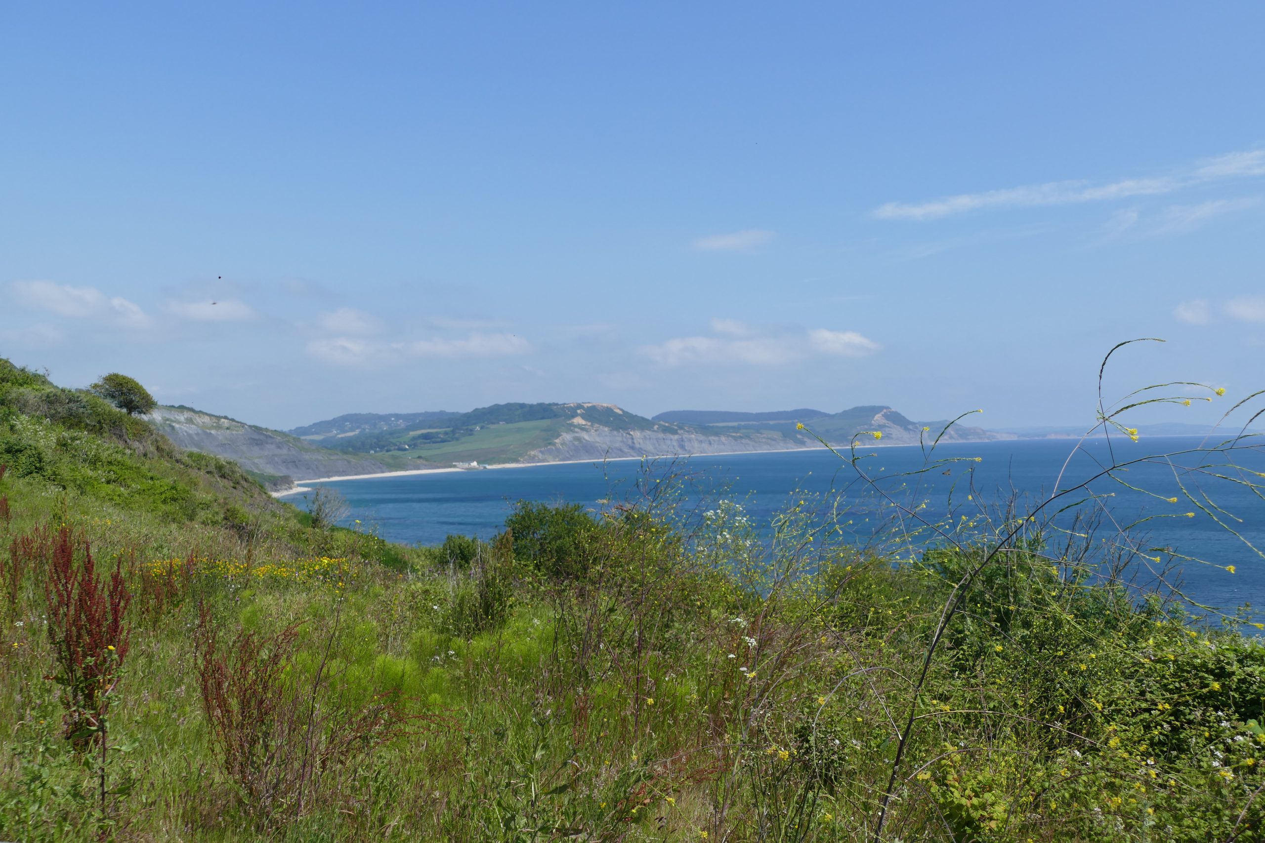
Our particular curtain is at the coast, where a steep cliff forms a dramatic full stop to the landscape. A pebbly beach has formed at the bottom. The cliff reveals what is hiding below the ground. It shows well-defined horizontal layers, clearly sedimentary: this land was deposited under water. The dark blueish rock is known as Blue Lias. It is quite a soft rock which is easily eroded. There are frequent landslips and rockfalls here which add their debris to the pebbles below. On this sunny day there are a fair number of people on the beach but it is not crowded. The coast lacks the grandeur of South Africa’s Otter trail or Australia’s Great Ocean Road (the one with the twelve apostles), but there is a quintessential beauty to the landscape with its century-old villages. But beauty is not what the people are after. They are looking for the ghost in the rocks: fossils.
The coast is known as the Jurassic Coast, and it is a Unesco World Heritage Site. Unlike Jurassic Park, the Jurassic Coast actually belongs to the era it is named after. It stretches for 150 kilometer along England’s southern coast, from Weymouth in the east to Exmouth in the west. But it is under attack. The longevity of the ancient cliffs is short-lived. Year after year the rocks fall and the waves carry the debris away. The Jurassic Coast is in retreat. It is that retreat which is bringing the fossils.
The Jurassic Coast. Photo by the author
The Jurassic coast was first made famous by Mary Anning. She lived in the early 1800’s in the small coastal town of Lyme Regis; a carpenter’s daughter from a poor family who had limited education. But she had a unique ability to find and identify the local fossils. Her finds became legendary and brought her international fame as a collector. Mary Anning was possibly the most famous fossil hunter of her time. The Royal Geographical Society (never the most progressive of societies, perhaps understandable for an organisation so firmly rooted in the past) did not accept women as members, or even let them attend meetings, and she could not publish there. Others published her discoveries: some gave her credit, some did not, and some gave her money in payment. None recognized her as a fellow scientist. Mary Anning died young, at the age of 47, of breast cancer.
Charles Dickens’ Christmas Carol was published three years before Mary Anning’s death. It is a famous story of change and redemption. It also about child poverty and a lack of chance in life. Mary Anning knew that from experience. Her background and gender became an insurmountable obstacle to a full recognition of her ability. Perhaps it isn’t just geology that plays the role of the miser Ebenezer Scrooge: scientists themselves can also do the job just fine. And expressing regret cannot be enough. To quote Dickens: “No space of regret can make amends for one life’s opportunity misused.”
Twenty years later Charles Darwin wrote an article about Mary Anning, He mentioned that her memorial window in the church has an inscription stating ‘her usefulness in furthering the science of geology’, and pointed out that “Geology wasn’t a science when she began to discover: Mary Anning helped make it one”. But change has been slow, and even nowadays science is still not a world of equal opportunity. Just one example: many geologists still publish their papers behind paywalls. It denies too many the right to read the work they paid for.
Back to the reality of the past. The most famous discoveries of Mary Anning were her ichthyosaurus and plesiosaurus fossils. In 1811, as Darwin told, she saw some bones sticking out of a cliff. (She herself said it was her brother who first found it.) Darwin described it as “Hammer in hand, she traced the position of the whole creature, and then hired men to dig out for her the lias block in which it was embedded”. This was the first known ichthyosaurus. Cuvier wrote about a later specimen: “..the ruins of a former world. It had a lizard’s head, a crocodile’s teeth, a trunk and a tail like an ordinar quadruped, a chameleon’s ribs, a whale’s paddles, whilst its neck was of enormous length, like a serpent tacked on to the body”. Cuvier’s famous fossil, still on display in Paris, was found and extracted by Mary Anning.

Nowadays the Jurassic coast is best known as a place to find and collect ammonites. The tourists we saw wandering the beaches were looking at the rocks and stones, and were trying to break them up with their hammers. (The hammers can be rented on the beach). It is legal to collect fossils from the beach; collecting from the cliffs themselves is not allowed as they are property of the land owner (often the National Trust). In any case it is better not to venture too close to some of the cliffs: there is always a risk of a rockfall. An ichthyosaurus can still do serious damage to the keen collector! (And on a serious note, fatalities among the tourists are not unknown.) The fossils will end up on the beach eventually: the tourists just have to be patient. And if that once-in-a-lifetime-find is not to be found, they can always be purchased from the fossil shops that still line the main street of Lyme Regis, in the footsteps of the fossil shop of Mary Anning. A decent ammonite is quite affordable: it can cost less than the rental of the hammer! The local museum provides an intermediate way: it allows the tourist to see some of the old fossils and their history without having to claim finder-keeper ownership. It is small but well kept, and it nicely depicts the world of the past that Mary Anning was envisaging as she extracted her fossils.
The fossils of the Jurassic Coast are notably marine in nature. The paddles noted by Cuvier left little doubt that this dragon lived in water. No Megalosaurus here! (Tyrannosaurus was not Jurassic. If that had been found here, it would perhaps have been called Tyrannosaurus Regina, in memory of the carpenter’s daughter who gave the Jurassic its world renown.) The only outliers are the pterodactyls, creatures of the air caught in the water. The first one was, of course, found by Mary Anning, in 1828.
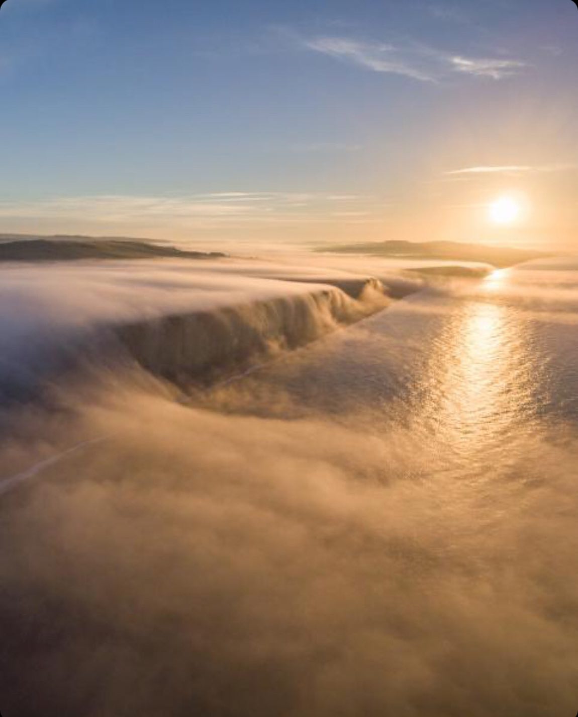
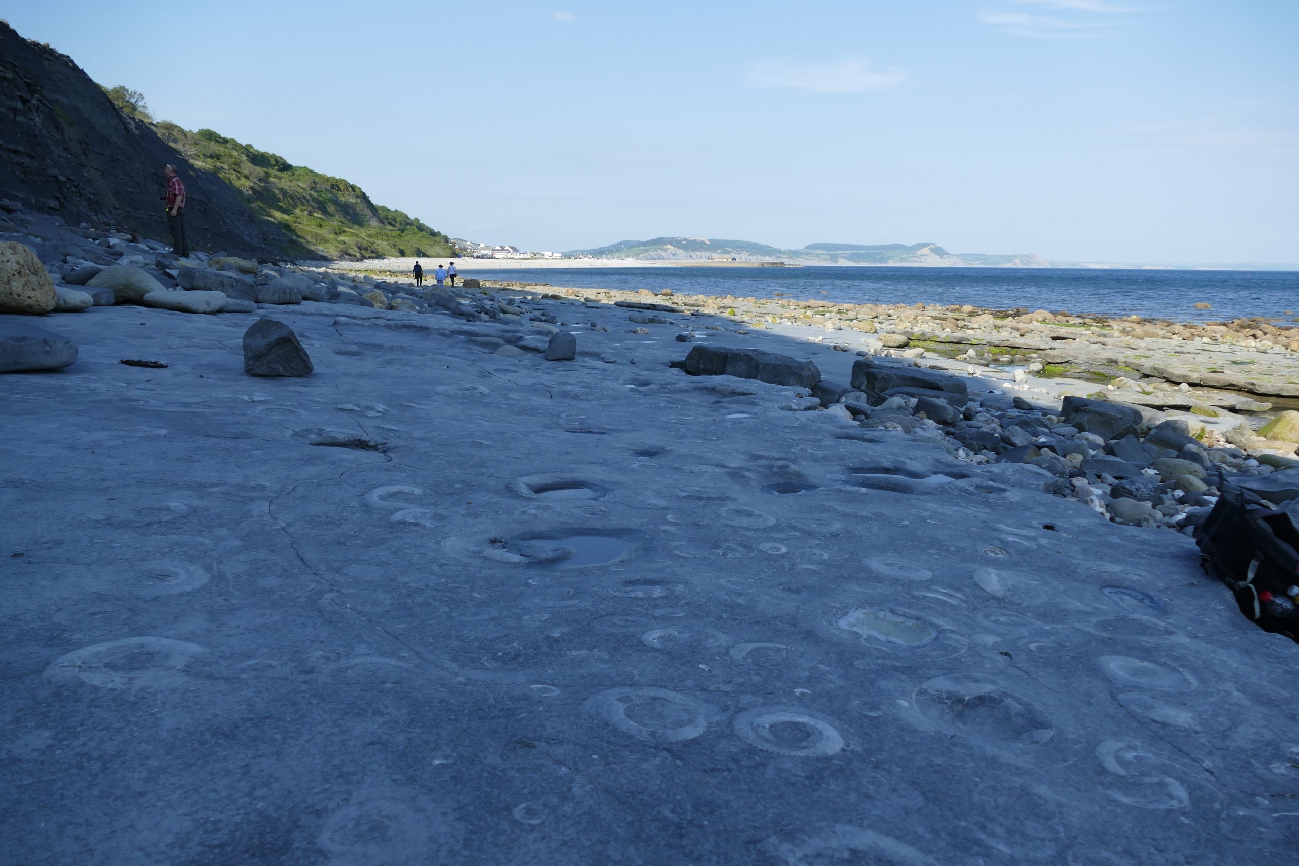
The most amazing part of the Jurassic Coast is something not many people get to see. Most people head for Charmouth and walk east along an accessible beach with finds enough for everyone. But even better sights are on the other side. We started in Lyme Regis and turned west, towards a rocky stretch which drowns at high tide. A guide is strongly recommended. Our guide first showed us some fossils incorporated in the stones of the local houses, before taking us past the harbour and a parking lot, on to those rocks. Knowing when this is safe is a major part of the responsibility of the guide: it can be dangerous to go at the wrong time. The other responsibility is to make sure that we left our hammer at home: collecting fossils here is strictly forbidden. After a while we reach a stretch with stepped, layered platforms. We step on and off the different layers as we follow the guide. The layers dipped a bit towards the cliff on a shallow angle. One of those layers is the guide’s goal. Standing at its edge, a world-famous view appears. Every part of the surface is covered with circles, some tiny, some half a meter or more across. They are ammonites, and this surface is their graveyard. It is called the ammonite pavement.
The ammonite pavement. Photo by the author
This too is a Unesco World Heritage Site. It may not exist for much longer: the storms break it up and every year the pavement is a little smaller. The guide pointed out the recent breaks. A large fragment was saved after such a storm. It is now kept in the National History Museum in London. It should have been on display in Mary Anning’s museum. If the Royal Geological Society wants its redemption, perhaps one start could be to arrange for this to happen! This particular curtain on the past may soon close. The past can be temporary.
The ammonite pavement is a 30-cm thick limestone slab which formed 200 million years ago. The surface consists for 40% of ammonites! The area was in the subtropics (30 degrees north of the equator), when this was a shallow, at times muddy sea. The mud collected on the sea floor, a bit like Scrooge’s gravy. The ammonites which were swimming in the shallow sea would on their death sink and become buried in the mud. Some were buried complete, others as shell fragments. Look hard and you can still see those fragments in the pavement, together with tell-tale trails made by burrowing worms. The ammonite pavement formed during a time when rather little mud flowed into the water, over a period perhaps as brief as a thousand years. This allowed the concentration of ammonites to build up so high. Later the mud flowed faster again, and the ammonite-pavement-to-be became buried. The layers that we saw above the pavement were far less rich in fossils.
Why did the shells survive in the mud? In a way, they didn’t. The living shells consisted of aragonite, a form of calcium carbonate which slowly dissolves in water. But the shallow sea at times had low oxygen levels, and this slowed down the dissolution. When this happened, there was time for the aragonite to slowly change to calcite, a more stable form of calcium carbonate. The anaerobic mud protected the shells and gave calcite its chance. Often, only the bottom half of the ammonite is present in the pavement: the part of the ammonite that was covered in the mud had time to fossilize, whilst the part sticking out above the mud dissolved into the water and left us no trace.
Sometimes iron sulphide finds its way into the chemistry, and the calcite becomes replaced by pyrite. This gives a golden glow to the fossil, and in fossils shops the pyrite shells may be given pride of place. But pyrite can quickly oxidise when out of water. If such fossils are kept under high humidity, the pyrite will oxidise to iron sulphate. This is an expansive mineral: it takes up four times the volume of the pyrite. The expansion causes the fossil to fall apart. Once the process has started, the decay is unstoppable. It is best to keep the fossil at a humidity below 40% – but it is better to leave the pyrite ammonites in the shop. It is called fool’s gold for a reason.
Follow the coast
Fossils are a true ghost of Christmas past. They seem to shout at us: “Come in, — come in! and know me better, man!” wanting to show us a glimpse of life in the past. But there are other, fainter ghosts. They are shadows, and not easy to see against the landscape. They are the landscape. Geology does not need fossils to show us the past. Dead as a doornail they may be, but the stones themselves are geology’s legacy.
Not all the Jurassic Coast is Jurassic. This can be seen best from out at sea. The horizontal layers are clearly visible in the cliff, but from a distance it becomes clear that they are not horizontal. There is a bit of a tilt down towards the east. Each layer dates from particular epoch; the one above will be younger. Because of the tilt, the cliff is younger towards the east. Over 150 km, the age difference adds up enough that the eastern-most areas of the Jurassic Coast are Cretaceous, not Jurassic. (‘Cretaceous Coast’ would have had a nice ring to it.) The central areas are, true to the name, Jurassic. The western-most area is Triassic. The change from Jurassic to the older Triassic is clearly visible in the rocks. Go too far west and the fossils become rare. The region around Lyme Regis and Charmouth is best for fossil hunting.
The age of the 150-km long coast ranges from 250 millions years in the west to 65 million years in the east. For England, this long epoch was a quiet spell in its geological history, when the country was in the centre of a supercontinent, Pangea. This may seem surprising, in view of the ammonites and ichthyosaurus and ammonite fossils! The super-continent had come together in stages. One of those stages had formed Laurussia, the northern continent. Gondwana joined soon after, and completed the coming together, the Christmas family reunion. England was at the heart of the union.
Before going into more detail about the reunion, let’s first look at this surprising sea. Where did it come from? This had to do with the coming break-up. For by the time the coming-together party started, the break-up of Pangea was already in progress. A new ocean was extending across the super continent. It had started where is now China, and from there grew westward, dissecting Pangea. This was the Tethys sea. (There were several phases in its growth, but that goes beyond the story.) During the Jurassic the Tethys extended across southern Europe, into adjacent Mexico (the Atlantic ocean did not yet exist). The Tethys brought water into the centre of the continent. As the new sea grew, Europe subsided. At the same time sea levels rose, perhaps because of the growing activity under the sea which pre-saged the break-up. The combination of subsidence and sea level rise caused wide ocean bays to form across Europe, and these extended into southern England.
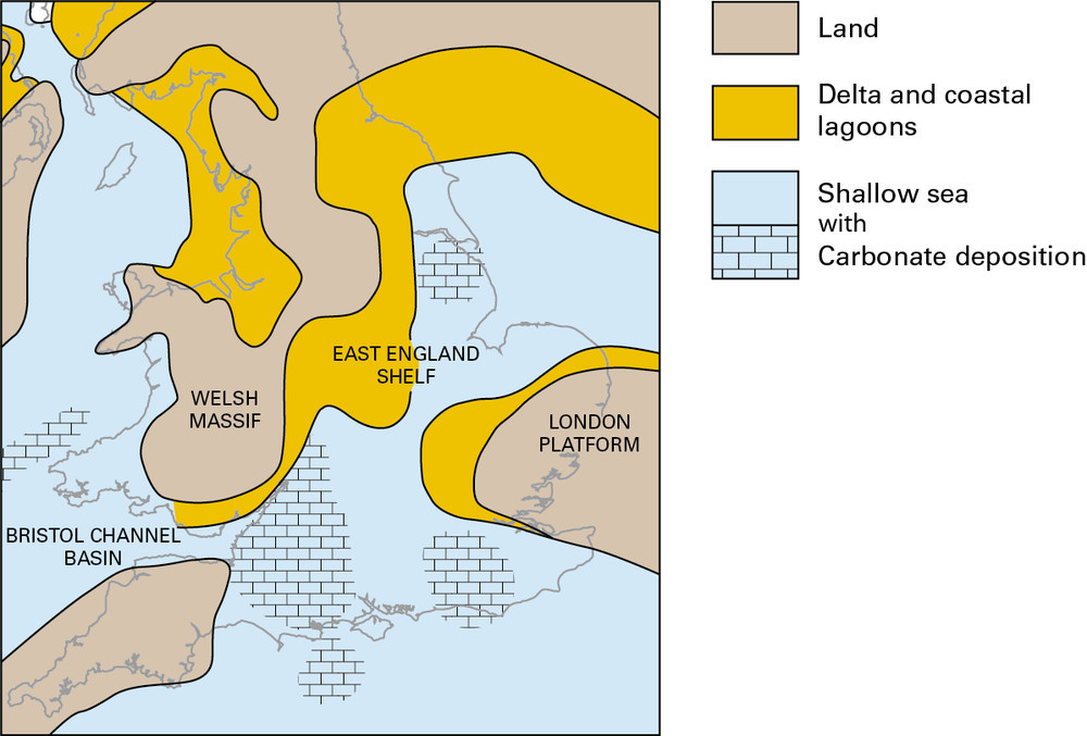
From the late Triassic this sea covered much of southern England. London and the Cornish mountains remained above water, as did Wales. This was the shallow, subtropical, perhaps idyllic sea that was the home of the ammonites, in which ichthyosaurus hunted and above which pterodactyls soared – no doubt nesting on the nearby land in Wales and Cornwall. The climate was seasonal; rainfall and temperatures fluctuated through the year. The closest sea shore, complete with lagoons, was in south Wales. A small archipelago had formed around Bristol. This large bay was the environment in which the Blue Lias was deposited, the grey blue layered mudstone which forms much of the cliffs around Lyme Regis. These were the rocks from which Mary Anning dug out her fossils, and this was their history.
Exeter castle
But history itself has history and geology builds on older geology. There are more ghosts to be found. The sea had brought life into a lifeless region. In the middle of the continent, this had been a hot and arid desert, the Sahara of its days. To explore the deeper desert past, go west, to the oldest end of the Jurassic coast where the sediment of the sea ends and the red sands of the desert take over. The ancient town of Exeter is here, along the river Exe. At one time this was a Roman army base; an odd place perhaps, so far from anywhere. The town continued after the Romans had left, and in the 11th century a cathedral and a castle were build. They are still here. The castle lies on a ridge overlooking the river. The building stone was taken from the local red sandstone, laid down in the days of the desert. But the ridge that the castle stands on is not sand. It is basalt, and it is a ghost from another past.
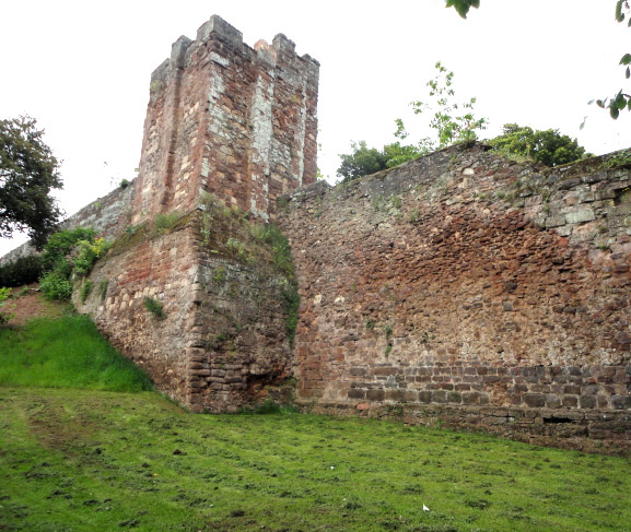
Exeter castle
The basalt was erupted 280 million years ago. It crops up in several places around the centre of Exeter centre and is known as the Exeter volcanics, or more optimistically as the Exeter traps. The castle ridge is a remnant of the fissure vent. It is a small remnant of a significant effusive eruption; originally the basalt must have spread much further, although in no way wide enough to warrant the title ‘traps’. And it too found its way into the town buildings. Whereas the castle and inner and outer walls of the cathedral were build from the desert sandstone, the loose material between the inner and outer cathedral walls, and the stones of the city walls, are volcanic, mined from the various local outcroppings.
Not all magmatic heat reaches the surface. The thick crust below mountains can become hot enough to partially melt. The silicious liquid creeps upward but it isn’t able to reach the surface, and instead solidifies on the way. This is granite, and it too is found here. It is no longer deep below the mountains: the long years of erosion have brought it to the surface.
A line of such granite outcroppings runs along the spine of Cornwall, from Dartmoor in the east to the Scilly Isles in the west. Dartmoor is the bleak location of the Hound of the Baskervilles: it is just north of Exeter. It has the same age as the potassium-rich basalt of the Exeter traps: it is dated to 280 million years ago. (The granite further west is a bit older.)

And this brings us to another story, twice as old as the Jurassic Coast. Just like the carpenter’s child has an echo of Christmas, there is an another echo of Christmas here, that of the child refugee. For England had first arrived as a migrant. Quoting Dickens: “the spirit within him should walk abroad […] and travel far and wide”.
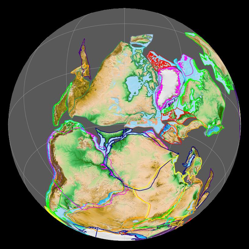
The story takes us back to a time before the mid-continental desert. The world consisted of three parts. In the east was Baltica, the ancient shield of northern Europe. In the west was Laurentia, the North American continent. In between was the Iapetus ocean. To the south was Gondwana, across the 4000-km wide Rheic ocean. (In mythology, Rhea was the sister of Iapetus.)
This was when the world was coming together. First the Iapetus ocean closed, 450 million years ago, forming the northern continent of Laurussia. The collision caused a mountain chain to form. Nowadays these are the mountains of Norway, Scotland and America’s Appalachians. Gondwana was approaching. But where was England?
It was in none of these places. England had originally been part of Gondwana, part of what is now South America. A microcontinent split off and began to drift northward at some 10 cm per year. The microcontinent is called Avalonia, and it contained England. (Another microcontinent, Carolinia, may have been attached to Avalonia at the eastern end, or it may have drifted independently nearby.) Avalonia arrived at Laurussia shortly after its formation. It extended Laurentia into the future USA, added England to Scotland, and created north Germany.

Avalonia is often depicted as a long, thin sliver of continent. In reality it may have been a bit less extreme in its dimensions. The docking can lead to significant shortening of the terrane, leaving it much longer than it is wide.
 While Avalonia docked, the Rheic ocean began to close behind it. It was a complex process, much less straightforward than the closure of the Iapetus ocean before. Another microcontinent had split off from Gondwana, and this arrived just ahead of the main continent. It is known as Armorica, and it plays an important part in the story. While Avalonia had come from South America, Armorica was a fragment from Africa. Now Armorica docked to Avalonia, and extended Laurussia further. Armorica added Brittany and the Channel Islands, and the tip of Cornwall. Surprisingly, Iberia was also part of Armorica, attached to Brittany. Iberia would later rotate 180 degree to its current location.
The docking was complete by 400 million years ago. The complex process left a fragmented series of mountains across Europe, from the Czech republic to Cornwall. Together this is called the Variscan orogeny, the assembling of Europe.
But this was not the end. After the merger of Armorica and Avalonia, it appears that they briefly separated again. A spreading ridge along or close to the suture formed a new ocean. One suggestion is that it resulted from the attempted subduction of a spreading ridge of the closing Rheic ocean. This temporary basin is called the Rheno-Hercynian ocean. It remained a narrow gulf, extending from central Europe westward, a bit like the Gulf of California. It lasted 20 million year; its closure caused the fold belts of Cornwall and Southwest Iberia. Continental collisions can take time.
330 million years ago, during the closure of the Rheic ocean. Source: wikipedia
The full closure of the Rheic ocean lasted 100 million years. The last fold around Cornwall is dated to 290 million years ago.
But the final closure was still not the end. A few million years later, the granites from Dartmoor to the Scilly Isles formed (if you’d like to know, it is called the Cornubian batholith) and shortly after this the Exeter volcanics happened. Mountain ranges which form from continental collisions have little volcanic activity, because of the lack of subduction. They do form granite, because the pressure at the root of the thickened crust is sufficient to melt the lightest component of the crust, which then move upward but never get near the surface. The suggestion has been made that a thin part of continental crust of Gondwana had been subducted underneath Europe. This melted, and it produced the vast plutonic intrusions of which the granite remnants are still present. But the Exeter volcanics are basaltic, not continental. This suggests Exeter may have benefited from the old spreading ridge of the Rheno-Hercynian ocean, now stuck below the continent.
After the final merger, a quiet phase followed. These were the dry years when England was at the heart of a supercontinent, when rain was scarce and a massive Sahara spread across the country. Like a never-ending 2020, the social isolation lasted for more than 50 million years, with only sandstone to show for it. These were the glory years of Ebenezer Scrooge, leaving us little or nothing.
A Christmas present
Among the most memorable phrases of the Christmas Carol are the words of Scrooge’s nephew: “I have always thought of Christmas time, when it has come round—apart from the veneration due to its sacred name and origin, if anything belonging to it can be apart from that—as a good time; a kind, forgiving, charitable, pleasant time; the only time I know of, in the long calendar of the year, when men and women seem by one consent to open their shut-up hearts freely, and to think of people below them as if they really were fellow-passengers to the grave, and not another race of creatures bound on other journeys. And therefore, uncle, though it has never put a scrap of gold or silver in my pocket, I believe that it has done me good, and will do me good; and I say, God bless it!” Geology is like that. It creates nations but leaves them with only faults and fossils. But in fact, in this case there was a more economically valuable legacy. It may even have been the reason for that Roman legion in Exeter.

Strabo’s map of Europe with the tin islands
The valuable legacy is cassiterite. It is a tin ore, and tin became a valuable commodity in the bronze age. Bronze is an alloy of copper and tin. On the map of Europe of Strabo, Western Europe is rather poorly depicted. But off the coast of Iberia, two islands are indicated, and names as ‘Cassiterites’. This must have referred to Cornwall, albeit by someone who clearly had never been there. The tin mined here was widely traded. The famous Nebra sky disk, the oldest known map of the sky, was made with tin from Cornwall. The Cornish (and western Devon) mines also produced lead, copper and arsenic. More recently, wolfram was mined. There was wealth in the ground. The mines were active until fairly recently, but are now mainly a tourist attraction. They are, in fact, another Unesco World Heritage site.
The ores formed from material brought up during the final days of the coming together. It was not only in Cornwall. The ancient mines in the Czech republic, now known as the Erzgebirge (Ore mountains), also date from this period. The most famous location here is the Joachimsthal, a valley where the metal used for minting coins came from. The German word for valley is ‘thal’, and this became a byword for coins. It morphed into the old word ‘daalder’, and from there into the more familiar ‘dollar’.
The wealth of this Christmas present thus ended up in the people’s pockets. And it left us with yet another ghost of the past: an echo in our language that goes back to the halcyon days when the Rheno-Hercynian ocean closed. Exeter is the tip of an iceberg which brought us hidden riches.
Mapping of the ore veins in Cornwall has shown that they only occur above the crust of Armorica. The part of Cornwall and Devon derived from Avalonia lacks these deposits. But the intrusion which brought up the riches happened only after the two parts had come together. It should not have known about suture. It appears that the deep crust of Armorica must have been different from that of Avalonia: one contained these riches, the other did not. After all, they came from very different parts of Gondwana.

From Dijkstra, A.H., Hatch, C. Mapping a hidden terrane boundary in the mantle lithosphere with lamprophyres. Nat Commun 9, 3770 (2018).
And this brings us to the end of the story. It has taken us from the Jurassic Coast to a much earlier time, when Europe was assembled. Our land has a hidden past. It has left us ghosts in the landscape, wanting to teach us, if we know how to listen. We are all children of an ancient land, living in the past, the present and the future. Our self-found ammonite may not be as impressive as those in the shops, but what a story it has to tell.
Albert, December 2020
More on the story of the English Channel
From all of Us to all of You
Merry Christmas and Happy Holidays!


Happy Christmas everyone!
Happy Christmas Albert and to all at VC!
Happy boxing day too 🙂
Happy Christmas, and again thank you for the gift of knowledge!
Thanks Albert! What an article. So thorough and so informative, and a great read.
It reminds me of a TV programme I saw about twenty years ago, where a reporter was picking through rocks on the Jurassic coast beach. They put the camera on the ground to film him picking up and studying a rock. He tossed it back, disappointed that there was no ammonite. Yet the camera angle clearly showed a fantastic example on the back of his rock! I had a good chuckle over that.
Albert, everyone, have a Happy Christmas, and let’s hope the New Year brings good news!
Thanks again, Albert. That was a very nice Christmas present.
The increase of the lava lake is really slowing down now. It is around 25 cm per hour now. If it continues to decrease at that rate, then the lava lake will not get much above 180 meters depth.
Its the fissure thats submerged
Have the output really slowed?
Even if it stops now .. it will come back ( next year )
This is not an open conduit circulation lava lake
The old overlook was basicaly a shaft down to the magma chamber
The current is not
The tilt has also mostly leveled off, so probably the inflow is now coming mostly from base supply and is probably pretty low. Given the rather large output of the east vent and lack of any real tremor its probably more a cylindrical tube into the magma chamber now, so if nothing changes much it should just keep going. In a year the view might be of a much smaller lake that is perched on top of a shield, possibly overflowing the deep pit and becoming visible to the overlook.
So its getting constant now?
Possibly 🙂
Its the pahala sourge and these decades huge yearly magma supply to Kilauea.
In the last 20 years Kilauea haves gigantic yearly supply. This explains why Kilauea have recovered and re-erupted so fast after the holuhraun sized eruption in 2018
But its still dropping the deflation.. in 10 hours we will know if it will continue
It is dropping but not nearly so much as before, the GPS too is not dropping so fast the last 2 dots are close together so the initial fast stage seems to be soon to end. If the lake drains then there will be rapid reinflation, probably at least half way back to the beginning point.
It is crazy how deep the lake is, the volume is typical of observed summit eruptions but at more or less 180 meters deep it is nearly twice as deep as the one in Kilauea Iki. Only a week ago there was a water lake there… Pu’u O’o changed almost daily, Halemaumau will do that too from now on, it is entirely plausible in a few years we see pahoehoe flows overtop the caldera into the Kau desert, and just as plausible a new Pu’u O’o on the ERZ as per Hectors prediction.
I do hope an Icelandic volcano erupts in 2021, to break up the likely year long Hawaii talk 🙂
180 meters deep is impressive.. will be amazing columnar joints hexagons inside. And it will be buried under 100 s of meters of New lava layers when hexagonization is compete.
Chad when it stops.. how fast does the crust thicken enough to you to be able to stand on it?
Probably after a few weeks, but there is a good chance that point will never really happen if the eruption keeps going. 1952 the lake surface hardened and it formed cones and flows with the lake also rising passively. Same in 1967 which was also notable for its very abrupt start just like this eruption, an hour of obvious warning after about 2 years.
The island seems to have gotten stuck near the vent, so a cone might begin to grow in the next weeks as well as the edges crusting over towards the middle, it might start behaving like those other eruptions soon. We are still very early into this, the 1952 and 1967 eruptions lasted months, and 19th century eruptions lasted for years sometimes, this is only 5 days in yet 🙂
The deflation have stopped now .. so its going constantly
The lake is also level to the vent, its still fountaining so looks to be in for the long run which is good, except for the vog is still very high much higher than a few years ago.
There also has been an area of persistent very shallow quakes that are near where the second 1982 vent opened, I think that is shallow magma and when the crater floor rises to this elevation there could be an eruption here. It also could be showing magma pressure towards the southwest rift, I would very much like to see a slow eruption happen there, as I said before the Kau desert is a perfect place for lava tourism, no danger, long lived, very close to the main highway, inside HVNP. Mauna Iki is a popular desination for that reason so another eruption like that. If that doesnt happen then the summit might overflow instead and we get the same result 🙂
The smaller vents are now dying as USGS confirms now ( small deflation keeps going )
The main vent vill likley die in the comming weeks to months, its perhaps not vigorous enough to form a New centruy long Puu Oo looking lake shield in the caldera
West fissure was higher up, its all reaching equilibrium. North fissure is unchanged, eruption rate is lower but its not closing up. The vent is now probably an actual conduit, not just a flat dike it is circular in cross section so even when pressure goes to flat it will still be there full of lava. If theres no supply it ends anyway but here that is not the case, so with no other changes this vent will just stay open with low eruption rate filling the caldera. That is typical of Kilaueas summit activity, overlook crater was a big exception because it had a lateral drain so basically never overflowed, most lakes have grown into perched ponds and shields, give this a few weeks.
I dont know for the time between 1924 and 1952, I would assume the supply was a bit lower because Mauna Loa was more active so some magma was going there, and the east rift was probably also refilling, so no extra magma to drive long eruptions, neither is the case now. Only thing I see terminating this is more east rift activity, but nothing down there as of right now.
USGS today says the lake is 21 million m3, 176 meters deep and it rose 6 meters since yesterday. 21 million m3 is a rate of about 4 million m3 a day.
It rose 12 meters up to yesterday and 25 before that, so its sort of half as much each day. It will probably be 3 meters today 🙂 probably wont rise after that much, which is at about 180 meters deep.
The crater is an inverted cone, given a steady magma supply it will take longer and longer to fill, as the volume to fill for a given height becomes ever larger the higher you get above the crater floor.
Thanks Albert for a wonderful christmas read!
Bravo, yet again !!
FWIW, be very, very careful on the ‘Jurassic’ and similar ‘soft’ coasts as prone to frequent rock-falls, ranging from mere skull-crackers unto ‘bury the beach’. Undermined by storms, digested by salt-spray, pore-pressures spiked by heavy rain or lowered by drought– Oopsie, there goes another chunk…
Although UK coasts are rarely ‘active’ enough to feature on…
https://blogs.agu.org/landslideblog/
… he does cover lahars etc…
https://m.youtube.com/watch?v=B_SNUf5udMU
Biospheres of Planet Tira 292B is up
Part 9 the Tropical Rainforest. This the the most amazing spectacuative evolution project on the entire internet.
You must watch all parts of this seriers
Part 10 is comming later
Based on the 24 hour replay on the thermal cam, the lake has now pretty much stopped rising. The main vent is also now erupting through the lake, and it looks like the crust on the opposite shore is actually sticking to the edge, the surface is beginning to freeze over as the lake isnt rising anymore. It also looks like the island is going to enclose the vent soon, its still floating but it is definitely in contact with the edge of the crater somewhere under the surface. It seems likely the rest of the lake surface will crust over this coming week.
Wait and see. If the eruption stops, the lake will freeze over. If it only diminishes, the surface will remain cracked. A complete freeze-over is actually not without danger. Gas from the lava below collect underneath the solid layer and this can give sudden, unpredictable explosions months later. It happened in Agung after its eruption ended.
Probably not, the lake has no spattering sources anywhere except the north vent so it is probably all degassed, and Agung was not a lava lake it was an andesite dome. Theres no records of a post eruption lava lake exploding this way at any basaltic volcano, and at Kilauea these rootless lava lakes have formed dozens of times in recorded history and also on Mauna Loa for which there is similarly no cases.
Because the vent is on the edge and is also blocked off by the island most of the lake is not really that close to the source, it will probably solidify but the part between the vent and island likely wont. Then shield building might begin.
A platform of solid lava has started to form around the lake, it’s wider at the lower right. A dark (cold) ring of spatter separates it from the lake, and frequent overflows overtop the ring into the platform. Looks like the lake has already reached its maximum extent and is now starting to shrink from the sides, it can rise further though.
Thanks Albert, great article.
Happy Christmas to all!
Happy Christmas and here’s hoping 2021 is a better year.
https://www.usgs.gov/volcanoes/kilauea/deformation-data
Kilauea have started to inflate again!
So the eruption is probaly going to be a constant feature
New vent in the lava lake as the summit inflates
Yes I just spotted that at the bottom as it looks like the main vent is getting submerged.
The spatter cone round the main vent shows nicely right now.
Kilauea continues to inflate with magma. And these vents opened up just above the lava lake, perhaps erupting at input levels.. looks like we will have a long lived eruption
This is the west vent that was behind the edge of the crater wall, not a whole new vent, but it is still an interesting change and I think one suggested before. You can see on the 24 hour thermal cam that the change is abrupt and immediate, and that there is also no drainback into the vent… The island also has immediately started to move in the direction of the new lava cascade, it is still floating.
This vent is going while the summit inflates quickly ..
Inflation rising very fast now
The volcano may have a magma supply thats well above 0,2 km3 every year.
If this fissure keeps pouring for a very long time without affecting deformation then thats proven supply
That is true, though this eruption is so far of pretty normal size, about 22-25 million m3, it just filled in alot of a deep pit. HVO has said this eruption is similar to 1952 and 1967, and less similar to 1959 which was much taller fountains and probably a far higher gas output.
Of course, 1967 lasted into 1968, and then in late August 1968 not 6 weeks later there was a fissure eruption in the chain of craters area, then another near Napau in October. Then a 3rd and rather large fissure eruption in February 1969, and finally Mauna Ulu beginning in May. That is all within a year of the lava lake draining… Todays lake is much lower elevation but as the crater fills we might see the same sequence in the future, or maybe just the summit overflowing.
Theres a lot of possibilities, but going back to sleep for a long time is not one of them today, we are a week into a decade long eruptive episode, just exactly how that will play out we have to wait and see 🙂
HVO confirmed that the lake is draining. From the USGS Volcanoes Twitter: “From the ground & air, #HVO field crews have noted a “black ledge” forming around the rim of the #Kilauea2020 #lavalake & raft. Its appearance signifies the lake level has dropped from a high stand. Lava is draining back down the north vent! West vent continues to erupt.”
It is interesting the lake is draining but a vent continues to be vigorously erupting, the draining was not very big either only 2 meters, not 90 like it could have been. The north vent I think will reactivate but the lake surface will probably crust over without it, this did happen in 1952 where the main vent at the beginning of that eruption was very erratic and often stopped later on. Really Halemaumau now will probably behave very similar to Pu’u O’o, just on a way bigger scale.
USGS volcanoes FB page haves nice photos of the New lava lake
This stuff is so fluid it looks like liquid aluminium! but scale is important too its almost 700 m wide but the viscosity must be very very low
Looks that as the north vent was drowned, lava started to slowly drain down into its conduit , activity immediately shifted to the west vents and the volcano was back inflating. There was also higher tremor than usual for about 2 hours after the west vents reactivated, looks like they were going strong initially. The floating island immediately turned towards the west vents too.
The important bit I think right now is that the main vent has died and the lake drained a bit and caused some reinflation, and during all of this effusion has not actually stopped… it would be very typical if not for that fact, but because the volcano is inflating again while the eruption is still ongoing this is not going to end yet.
The current inflation looks just like a DI event.
The effusion rate is still higher than the base supply, the inflation I think is from the draining of some of the lava back into the north vent. I would imagine there is a point where the north vent will reactivate, this might be after a few days like it was in 1959, the lake might not stay completely molten on the surface for that long though. The base rate is probably similar to Pu’u O’o, it might be higher, we will know how stable the vent is probably in a few days. In any case this is only a quite small pressure release, Kilauea will erupt within a few months if this eruption stops soon.
Why would lava drain back into a vent with such a pressure that the whole area inflates? That doesn´t go together well.
The area deflated because the magma was forced out, then some drained back because it is degassed and more dense. This happened in 1959, actually in that eruption there was initial deflation but as the eruption went on it had net inflation because more magma was resupplied from depth and after the lake reached the vent in the first week anything erupted just drained back again so there was almost no net eruption. It has not been long enough to tell if that is happening now but it is more than likely, we will see.
The inflation also started at pretty much the exact time the north vent died. The west vent is still erupting but that seems for whatever reason not important in this matter.
I agree on the easy part where supply from beneath causes inflation and that, once out, the mountain deflates. I also can picture drainage events because there is room from magma moving away or degassing.
What I can´t see happening is inflation of the entire mountain because lava drains back into the feeder channel. The only thing it has in that sense is its own weight, and while that might cause local uplift further down along the rifts, it wont inflate the whole caldera/mountain. It´s not like it´s being pushed back down.. It is hotter than the surroundings and the whole system is open.
More likely seems that a new batch of magma causes inflation of the whole mountain, and that this inflation widens the feeder channels, creating new room for lava from above coming back down temporarily until the new batch flushes everything out.
That is also probably the case, there is basically always new magma flowing into Kilauea, that is why Pu’u O’o lasted so long. It is probably both factors, because the lake isnt draining now while inflation is still going just a bit less steep.
On the 24 hour timelapse you can see when the west vents first reopened there was a sizable fountain.
Do you have a link for that please?
The webcams and 24 hour timelapses are found here:
https://www.usgs.gov/volcanoes/kilauea/summit-webcams
There is a new overflow onto the “moat” between the lake and the wall. I’m not sure the level of the lake has fallen on the southwest side, if that was the case it shouldn’t be overflowing like it’s doing now, I don’t see any signs of level drop next to the western fissures in images from the USGS either while the lake next to the north vents seems to have dropped a little.
Is that platform in the middle the one Sam and Frodo sat on as they slid down Mount Doom before the eagles picked them up? Ah the geologically unrealistic but wonderful Lord of the Rings. Mordor would be the biggest caldera ever and the Lonely Mountain is clearly a hotspot
The Vale of Udun in NW Mordor, right behind the Black Gate, is clearly a caldera. Then the names of the mountain ranges – mountains of ash? Perfect location for a fire maia (Sauron) to hang out.
Good spot – i’ve got a map picture on my wall and hadn’t noticed that.
Suppose you could parallel Mt. Doom with a Sinabung or Vesuvius.
Sea of Nurn could be a pull-apart basin.
Almaren looks exactly like Toba.
Anak Krakatau. This is from August but it hasn’t changed much since. Building up to the next collapse
Massive Aa flow erupted a year ago I think
The New Kilauea lava lake and the floating lava-berg Islands.
The lava lake is 700 meters wide and haves the features of very low viscosity
This looks very fluid.. Whats the viscosity here in Pa.s?
I always been fascinated by Kilaueas fluid summit lavas.
The western vent seems quite active today.
HVO reports now the SO2 is about 4000 tons/day, which is about the same as in the Pu’u O’o days. Probably now it is safe to say the eruption has reached equilibrium, as the inflation signal on the tilt has also been pretty slow. The lava lake is also not draining anymore, it filled by a meter from the lava erupted in the past day at the west vent.
This is looking promising for those of us (maybe just me) who want this to evolve into a shield building eruption 🙂
Perhaps it coud evolve into something like halemaumau was in the 1300 and 1400 s
Yes, a shield building eruption 🙂
The vent in the 1000-1250 eruption was actually not Halemaumau, the vent was called Kalua O Pele and it is probably the same as the Observatory vent. Halemaumau is only known to exist after 1790, referring to a persistent vent at the southwest edge of the caldera, and it is probably only in 2018 it had a collapse big enough to call it a caldera in its own right. There was possibly a vent here since 1500, but it is different from the Observatory vent in any case.
There is of course also the Aila’au vent, which Kilauea Iki is its summit crater, that was another separate vent. It is also possible there was no real topographical distinction separating these presumed vents, possibly it was a line of shields of which only the Aila’au shield wasnt consumed by the caldera.
The inflation keeps going and the fissures keeps going ..
Since late 2017 its been an elevated magma supply .. and in 2019 – 2020 really speeded up the inflation
Speed up in the last year is sort of expected, there was a collapse so decompression. I think there has been some increase since 2015 though, that is when the overlook lake overflowed for the first time. 2003-2008 also was a high supply period, though visually the activity was not unusual. I have been working on something recently that I just noticed about the current eruption, and perhaps its future behavio, that I am going to try to put into an article 🙂
This lava looks very very fluid
Even more fluid than fissure 8
It is likely erupting pretty hot, probably similar to the overlook lava lake, and the magma is comign from the same place. It is likely to be pretty much normal summit lava for Kilauea, tholeiite basalt and a temperature probably about 1200 C. The lake is probably rather less hot though, it has been sitting around for a week by now.
Inflation is stil going up.. will this evolve into a permanent open conduit lava lake? I knows that.. that takes time
Probably will not know that answer until at least mid January, assuming the eruption lasts that long.
Early on I did make a rough calculation the eruption might end on the turn of the new year, after 11 days. I do hope it keeps going past that and becomes a shield but it might be a year or two of frequent short eruptions like this instead. At least there is a not small chance of a big fountaining eruption, all the new magma on the way. If the supply can do 5 eruptions like the current one every year it ought to be interesting.
The “new supply” is temporary, related to the deep tremor outburst of early 2019, it could last several months or more than a year but it will to back to normal levels eventually.
Correction: there is no inflation. The tilt has changed direction, but the GPS is continuing to go down. The pattern of deflation has changed, but it is still going down.
Im not sure the GPS is still going down, there are only 6 data points showing a drop while there is at least 1 more full day since, it hasnt updated yet.
A reduction of pressure along the rift in any case makes sense, the summit storage is still voluminous, several km3 in volume, so its not that magma actually has flowed back up from the rift to erupt, it is a hydraulic connection and because there was increased pressure on that part of the system too once a vent opened the pressure was relieved.
This eruption is also at low elevation despite being a summit eruption, the west vent active now is at the same elevation as the rift just east of Pu’u O’o, so all of the UERZ is higher up. Pu’u O’o has shown slight contraction but JOKA station has not moved.
Actually my estimate of up to 5 eruptions like this one in the next year is based on 0.1 km3/year, which is somewhat under the current real value, there is rift filling but if there is more magma than usual for a year then things are going to be interesting, the caldera wont overflow but plausibly it could fill to the level of the downdropped block this year, at 900 meters elevation. At that elevation it might begin intruding the southwest rift, and activity will be visible from legal vantage points in the caldera too.
Tiltmeters records inflation of Kilauea now .. but she is inflating almost constantly these days
A quick trawl through the GPS’s shows that UWEV (north rim) and OUTL (SW rift) have rebounded a bit but only since yesterday – before that they were deflating. They went up by 1-2 cm after 8cm or so of deflation. CRIM is closer to the action than the other two, and it is still deflating. It went down a cm yesterday. Weather can affect the measurements (rain gives inflation) but it seems pretty uneventful there at the moment although I recall a message stating that it was windy there a day or two ago. HVO has access to more data than we do, and they report that “Summit tiltmeters continued to record weak inflationary tilt”. These are very accurate but only measure a slope, and only at one location. You need the GPS’s for the interpretation, and those suggest that the north and west side have rebounded a bit, but the southeast rim has continues to go down. We’ll know more when the next data are released.
The GPS take time to update, a few days, the Uwekahuna tiltmeter is usually up to date and is very accurate, reflects pressure changes in the shallow chamber of Kilauea with great precision.
I have never seen weather throw the Uwekahuna tiltmeter off, only nearby earthquakes have altered it sometimes.
The north component of the Uwekahuna GPS also shows deflation stopping around the 26, though it’s hard to tell if it has inflated or remained flat since, given that it has a lot of scatter.
The UWEV-CRIM line shows a little extension too in its last data point, so signals do point to inflation, but the GPS will take time to reflect a clear trend.
The GPS measurements are published once a day. However, the data is sometimes recalibrated after a few days when better data on satellite orbits becomes available. So the last few data points can sometimes change. Typically, if you see GPS go one way and caldera width the other, it points at a calibration issue. It is most obvious on Mauna Loa. I have seen rain-induced inflation in the past, but it requires quite a lot of rain.
The newest one just updated, it does appear to be slightly above the last circle. Its bery small but it is also consistent with the tilt so its not rain. There has not been much rain at the summit this week anyway.
Big quake in Chile. Looks like it’s in the same area as the 1960 Valdivia event.
M6.7. Off the coast in a fairly unpopulated area. Lucky.
A very interesting comment from HVO on the waning eruption: “Geodetic monitors also indicate that the upper portion of the East Rift Zone contracted while the summit deflated. This was associated with magma withdrawal to feed the summit vents. There is no seismic or deformation data to indicate that magma is moving into either of Kīlauea’s rift zones.”
In other words, the rift zone was feeding the summit. Whether it is a direct reverse magma flow, or that a normal through-flow stopped to the rift, is not clear from the statement. I would guess the latter: the flow into the upper rift zone ceased, but the flow from there down the rift continued.
Seems Ruapehu’s been taking U-turn lessons from the British government:
“GeoNet reported that the crater lake temperature has decreased since the last update. On 21 December the temperature reached a maximum of 43 °C that subsequently declined to approx. 41 °C. A lake temperature peak of approximately 40-46 °C is common during the heating-cooling cycles. The lake temperature exceeded 40 °C on at least 7 occasions since 2007. According to lake temperature decrease, estimated energy into the crater lake has decreased from 400 MW to 200 MW.
The elevated tremor continues accompanied with volcano-tectonic earthquakes. The largest earthquake with magnitude M 2.2 located under the volcano occurred on 26 December. Volcanic earthquakes of this size are uncommon and the combination with elevated tremor and still high lake temperature indicate moderate to heightened volcanic unrest.”
Jurassic and Cretaceous must have been a ”ultimate vacation spot” these supergreenhouse conditions. Europe was then a tropical archipelago, calcium calcite seas, that coud get up to 37 C in summer sea temperature. These long gone beaches woud have been bone white. I often imagines.. lonely walking some Cretaceous beach in Europe, in the blistering day heat and the night sounds of dinosaur predators. A world that where yet unspolied by future humans
European Islands during the Cretaceous era probaly looked like Fraser Island in Australia in enviroment. But with much more Mountains and volcanoes. The super – clear blue lake Lake Mckenzie (Lake Mckenzie (Boorangoora) at Fraser is probaly very similar evocative ( if you add salt ) to these long lost calcium Cretaceous Europe coastlines.
That woud be a fantastic feel plumging into these crazy clear dark blue Cretaceous calcite seas.. thats near body temperature … but lots of marine predators stalked these waters .. hungry eyes lurk from below
You probably don’t want to go for a swim with an ichthyosaurus. It would be like playing hide and seek with a salty
What were the oxygen levels like during the Cretaceous? I know during the Carboniferous they were extremely high. Just wondering how comfortable we would be if we went back in time to see a dino. Like they did in the short story “A Sound of Thunder”.
Ichthyosaurus proper was quite small, as were many ichthyosaurs, though dolphins are also faurly small and can be dangerous. Temnodontosaurus trigonodon was a different matter though, as big as a basking shark, apex predator of its time. It is though possible it will be reclassified to a different or new genus as Temnodontosaurus is a wastebasket taxon, but the animal is the same nonetheless.
Something only discovered this year is that despite their rather dolphin-like body plan Ichthyosaurs actually had flexible jaws and could swallow prey as big up to half their own size whole. It is possibly this reason very few actually had cutting teeth, they werent typically dismembering their prey.
The solar luminosity have gone up 1,5% since Jurassic ended so the future supergreenhouse made by the massive human industrial cO2 emissions maybe even more severe in the future than earlier natural hothouses.
Infact if we dont stop our massive emissions .. we will end up in the Cretaceous Thermal maximum again.. in just 200 years perhaps… knowing how fast the cO2 rises now because of us.
These Cretaceous supergreenhouse conditions
( 90 Ma ) must have created massive hurricanes and sluggish ocean currents, equatorial seas was close to 40 C in some studies during the most severe of the phases of meozoic greenhouse.
We may reach these high cO2 levels in a few generations ( two ) with our outputs .. but the polar caps down ar south pole will take time to melt.. and haves alot of cooling effect.
Supergreenhouse Earth is a very diffrent weather and ocean circulation system compared to today
Anthropogenic greenhouse effect will not be the beginning of a new 100 million year global jungle period though. It might last only a few thousand years, maybe up to 100,000 years, a weird anomaly in the successive ice ages that will be visible to any future intelligent beings. The reason why is because Antarctica is isolated by deep ocean on all sides, it might melt but there is nothing to prevent the cold circumpolar current from eventually restarting, then we go back to sequential ice ages. Only when the Drake passage is closed or Antarctica moves away from the south pole will the ice age end, and neither of those things is going to happen in the next few million years. There are other factors but this is the most important one, and the only one we cant change…
Yes thats true: a jungle era woud require a slow and steady release of volcanic cO2
Over millions of years. Cretaceous greenhouse was caused by very active mid ocean ridges degassing
It is not just that, in the late Cretaceous Gondwana was mostly fragmented but there was not a circumpolar ocean basin within the Antarctic circle at that time, it is the creation of the Drake passage that pushed the Earth out of a greenhouse, back in the Oligocene. In the Pliocene the Isthmus of Panama was created which also changed circulation, the ocean cooled down significantly after this, deep sea went from 15 C down to 3 C where it remains today. Plate tectonics I find is actually very rarely considered in climate models for the distant future, when it is a far more powerful force even than the greenhouse effect under the conditions of a habitable Earth. To induce a permanent greenhouse era with the current geography the atmosphere would need so much CO2 it would be unbreathable, or close to it, and at that point you risk a Venus event…
I imagine the next superchron or partial reversal will cause widespread volcanism and lower the temperature of the earth – mother nature likes to hit factory reset if things get out of hand.
Widespread volcanism gives a hothouse. The cooling effect you are thinking of is a brief initial event from the sulphur emissions. They wash out very quickly. The CO2 emitted by the volcanoes has a much longer lasting effect. LIP events coincide with very warm phases.
Future supergreenhouses caused by volcanism will also be problematic with higher and higher solar luminosity
A cO2 supergreenhouse 200 million years in the future will also occur with a 2% brigther sun
Do you know when solar luminosity will start to make Earth uninhabitable for humans and future humanoids?
Earth have compensating the increasing solar luminosity through geological time, by cooling off and becomming less geologicaly active with less volcanic cO2 output, but one day the sun will become too much
https://www.syfy.com/syfywire/why-is-earth-still-habitable-after-billions-of-years-in-part-were-just-lucky
https://www.youtube.com/watch?v=MzeSX8RXjhE
I found this today, it is in Italian, a short documentary on the 1669 eruption of Etna. After being able to watch fissure 8 it is rather striking how similar this was.
The current GPS data around Kilauea does not show much evidence for inflation. The numbers are within the noise of the previous numbers. The tilt has also flattened. Is the eruption still continuing?
its still going with 50 meters high lava falls pouring into the lava lake
Looking at USGS facebook night . video the lava is looking a bit more visocus now
This coud be beacuse old degassed lava from the lava lake is entering the dykes and re – erupting
Acually when it started it looked as fluid as ever.. but now the vent looks a bit more clotty perhaps.
Its still going at fast rates
Looks like this will last for quite a while.. its going and the weak inflation is still going so …input keeps pace with output… but its till a rootless lava lake.
This is a pond thats feed by circulating narrow dykes
The previous 2008 – 2018 was really a deep hole into the magma chamber… 300 m wide..and took 11 years to reach these dimensions
It is the same as when deflation started, initially only the tiltmeters were showing the deflation, it took a few days for the GPS to show the subsidence and contraction. Whereas the volcano is inflating or not deforming it shows an equilibrium.
The west vents have settled at low eruption rates that are either similar or smaller than the supply to the volcano (plus the possible drainback down the other vents). The west vents are 40 meters above the lake, so at the rate rate it’s rising it will take one month or a few to reach them, and by then the lake may be partially crusted.
The SO2 emissions are currently in the range of a few thousand tons a day and have been for a few days now, which is very similar to the Pu’u O’o rate before 2008. I would guess the output now is about the same. I doubt the entire lake can stay liquid indefinitely from that, it will probably crust over in the coming days to weeks. HVO has also confirmed a rise of a few meters, the crater is filling up again and the lava is apparently not draining anywhere.
The slowdown in eruption output caused instant inflation of Kilauea .. signs of a massive massive supply
Big earthquake in Croatia, at Petrinja and not far from Zagreb
Not good. Ljubljana. Slovenija.
“Pay to read”
“Greenland and its surrounding regions have many clues for understanding global‐scale tectonics of the Earth. Seismic tomography is a well‐established method for obtaining 3‐D images of the underground structure by inverting a large number of seismic wave arrival times. We obtain detailed tomographic images of the whole mantle beneath Greenland and adjacent regions using the latest dataset. Our high‐resolution results show that the so‐called Iceland plume could be composed of two plumes. One is located directly beneath Iceland but rising from ~1,500 km depth, which we call the Iceland plume. The other is rising from the core‐mantle boundary beneath central Greenland, which we call the Greenland plume. The Greenland plume has the main conduit and two branches in the lower mantle, and the main conduit rises to the mantle transition zone beneath eastern Greenland. Although the Iceland plume itself is a powerful plume, it may also have three joints with other plumes: the main conduit and a branch of the Greenland plume, and a plume beneath Western Europe, resulting in many active volcanoes in Iceland. The main conduit of the Greenland plume may also supply magmas to the Jan Mayen hotspot and a geothermal area in western Svalbard.”
https://agupubs.onlinelibrary.wiley.com/doi/10.1029/2020JB019837
https://agupubs.onlinelibrary.wiley.com/doi/10.1029/2020JB019839
Really interesting. Did they also discuss the hot track from the Iceland plume as Greenland passed over it? Also these other plupes should have created tracks as well..
This paper finds no support for the proposed hot spot track across Greenland. They find several hot spots with different depth underneath East Greenland and Iceland, and possibly Jan Mayen and Svalbard, but nothing under central and north Greenland. Other studies have claimed such a track. I don’t know the solution but it is a significant discrepancy.
I read a paper yesterday saying that the iceland plume is not a plume because it is not only in the vicinity of the MAR, the old caledonian suture crosses it. It inferred that the tomographic vertical anomaly seen rising up from the MTZ is actually down to a slab graveyard and it was therefore down to plate tectonics i.e. a zone that was always going to be prone to higher melt.
It doesn’t explain some things but it does explain why there isn’t a hotspot trail.
http://www.mantleplumes.org/Iceland1.html
USGS released new video from helicopter.
There’s something interesting about Halema’uma’u – it looks similar to Fernandina’s caldera in the Galapagos.
This rootless lava lake is enormous! over 700 meters wide!
Scale is kind of hard to get in these videos and photos. Its also so fluid its looking like aluminium. A small town center can be fit inside this lake. The lake maybe circulating in cracks and dykes.
But still its not like the previous 2008-2018 overlook lava lake… that was a 300 meters wide shaft hole into the summit chamber system. That was a truely open lake
They both have had recent collapses, difference is Fernandina doesnt erupt within its caldera much, so it doesnt fill. Kilauea also erupts rather a lot more lava, and with longer eruptions, Galapagos shields seem not to do actual shield building events, just big ring fault eruptions that are short lived.
Why is the ground steaming at the lip of the crater right before the video ends?
https://searchlight.vc/searchlight/breaking-news/2020/12/30/effusive-eruptions-taking-place-at-la-soufriere-residents-put-on-high-alert/
While Kilauea doing Xmas lake la soufriere produced a dome. Pictures are quite amazing.
The authority to follow:
https://twitter.com/uwiseismic/status/1344118651759288323
This one can go pretty big (VEI4) though according to volcano.si the repose time is shorter than usual if that means anything. The lava dome is pretty impressive. One to watch.
It had an explosive eruption about 7 years after an effusive eruption, back in the 1970s (1971-72 and 1979) and there was also the explosive eruption in 1902 that was at the same time as Pelee destroyed St Pierre, and which has also been at watch. Probably that bit means nothing, but as for the dome it seems to be like at Kelud, effusive dome then 7 years later it destroys the dome.
Good Morning Dragons and friends.
I just wanted to comment on the eruption in Hawaii and the filling of the caldera.
Reading the comments people were discussing how the rate of fill/rise in the lava lake surface had slowed. While others at or near the same time were suggesting that the input to the lake remained at a relatively constant (at the time of the comments.)
The caldera is effectively an inverted cone. So the flow of the lava into this cone will fill the lowest (narrowest sections) quickly. However, as the lava level rises there is now more space (volume) to fill for the same amount of input. As a result the lava lake rises less quickly.
I believe this happened in the early stages of the eruption where the eruption rate may have remained relatively stable but the volume of lava required to raise the lake another metre was greater. as a result the lake grew more slowly as the volume required to raise the lake a meter grew.
Anyway, the eruption has moved on. It appears that the lava lake has now reach a state of equilibrium of sorts and a drop of about 1m was noted in the last few days.
I releaize my comments are late the the show but I hope they are of value.
Happy new year to all
Richie
Its rising again.. and the drop of eruption rate have again caused an increase in inflation as magma supply react.. its still a rootless lava lake, the deepest ever seen in Hawaii. This is a very active system I think it wont sleep anywhere soon.
The lowering of sulfur continues but may remain at 3300 tons a day.
Deepest in the last 100 years in Hawaii. I would not rule out some of the lava lakes in the early 19th century being deeper, especially with some being 10x the volume of this one if not more.
We also dont know at all for Mauna Loa, few summit eruptions there are observed up close, but activity in the 1870s was intense within Mokuaweoweo filling a collapse from 1868, sounds a good bet.
Deepest ever seen by camera : )
It did drop, but today it was measured at 181 meters deep, so it seems to be rising again just slowly. I did also notice the surface seems less active today, it looks like the lake is crusting over, though that doesnt mean the eruption will end.
You are correct on the cone shape though, it will by my estimates take about 0.2 km3 of lava to fill to 900 meters and flow onto the lower caldera that sank in 2018. Even though the current lake is almost half way there in height already it is about 1/10 the way there in volume, it will probably take all year at least. That height is also when it will be easily visible at the overlook, for reference.
Correct but the rate of inflow has gone down, and by a lot. Over the first few days we had an average flow rate of 75 m3/s (it may have been higher right at the start). It went down to 30-50m3/s around christmas. At the moment it is even lower. For a 3 meter rise in one day (177 to 180 m), I get a flow rate of 10 m3/s. In reality this is an upper limit. The lake had done this change only over 2-3 days. There is some uncertainty as the level can also fluctuate with degassing levels. But I think the flow rate at the moment is no more than 5 m3/s. That also agrees with the large drop in SO2 emissions. A long-duration eruption in Hawai’i settles at around 0.09km3/yr. That corresponds to 3 m3/s.
The lake have stopped draining as the narrow dykes clogged.. its filling now. Deepest rootless lava lake ever seen by cameras
This is still a Rootless lava lake.. no open large conduit under it.
The 2008 – 2018 overlook lake was really a hole.. visible top of the deep magma chamber system
One for Tallis
https://www.nature.com/articles/s41598-020-67982-8
Disaster reported in Norway, near Lillestrom. Quick-clay collapse inside a town called Ask. There are injuries and the town is being evacuated
https://twitter.com/Nordic_News/status/1344208553943441413
Here is the area currently affected. There is a risk that it may extend further
And here is a landsat image taken 6 days ago. I assume that the landslide came from the southwest. That scar was not obvious in older images although that is speculative as the illumination is understandably not great.
Some 20 people are reported as missing
New post is up. The Kilauea update
https://www.volcanocafe.org/kilauea-eruption-lavabergs-fountains-and-drainbacks/
Eastern Caribbean Arc on alert as *several* of the ‘Usual Suspects’ seem to be stirring.
https://phys.org/news/2020-12-eastern-caribbean-issues-rare-rumbling.html
The most recent warning was issued late Tuesday for La Soufriere volcano in St. Vincent and the Grenadines, a chain of islands home to more than 100,000 people. Officials reported tremors, strong gas emissions, formation of a new volcanic dome and changes to its crater lake
Martinique’s … Mt. Pelee too is now active once again. In early December, officials in the French Caribbean territory issued a yellow alert due to seismic activity under the mountain. It was the first alert of its kind issued since the volcano last erupted in 1932
Meanwhile, Soufriere Hills in Montserrat, has erupted continuously since 1995…
i’m so late with this… i can only plead depression and over work. But it’s a lovely Christmas Gift… Thanks, Albert! It’s just perfect. i love it. Best!motsfo
Thank you! All the best for 2021