
Solfatara. The earthquake swarms are focussed between here and Pozzuoli harbour in the distance
I loved Naples. It is a lively Mediterranean city where there is always something going on. The people are amazing. I was told (a long time ago) by someone whose wife was from there that they were visiting the city, and his wife went somewhere and had told him in no uncertain terms to stay with the car. Which he did, but not at the car -stretching legs, walking a bit, always within sight of the car. When he came back, sure enough, the car had been robbed – unseen by the watching wanderer. You have to admire them. When I was there I was told which particular street to avoid if I valued my life, and had no problems – perhaps because I did not bring a car! The city is sandwiched between two volcanoes: Vesuvius, an excellent tourist introduction to what a volcano should look like, and Campi Flegrei, looking nothing like that. As Hendrik pointed out to us many years ago, the danger is in the hidden one, in typical Neapolitan fashion looking for an opportunity to erupt unseen while in full sight, like that unknown Neapolitan robbing the car.
The most recent eruption in Campi Flegrei started off-shore before migrating to land. It produced a nice new mount on the coast, did a lot of damage to the nearby area, wiped out an old harbour and caused half the population of Naples to flee towards it to have a good look – while it was still erupting. This all happened in 1538, and is described in a recent post. This was the first eruption (as far as we know) in 3000 years, was relatively small and was preceded by months (or years or even decades) of earthquake swarms. There had been plenty of warning. The first recorded earthquake swarm was in 1470-1472. After that, there was inflation, just a few meters (!) at first but eventually reaching 14 meters. There were a few more earthquake swarms, but they accelerated about 18 months before the eruption and became damaging in the months before the eruption.
After 1538, very little happened. There were major earthquake swarms in 1582 and 1594, but that did not lead to eruptions. Nothing significant was reported for centuries afterwards.
Of course, there were other problems. The area suffers from uplift and deflation -bradyseism- of up to 12 meters – the old roman town is now that far below sea level. One of the Roman towns in the area was at Pozzuoli, in the heart of Campi Flegrei. The unstable leveling was possibly one reason why it didn’t age well. A new city was build further down the coast, away from the unstable ground. This was called ‘New City’ of NeaPolis, which became known as Naples. (Actually it was ‘new’ compared to a hill side settlement much closer to modern Naples, but it is a nice story.)
The instability came back to Pozzuoli in 1950, after centuries of rest, when there was 70cm of uplift over two years. And in 1969 locals again began to notice uplift on the shoreline, affecting bridges and wharfs. Measurements confirmed that between 1968 and 1970, there had been almost a meter of uplift. There were minor earthquake swarms in 1970/71, too small to be felt. Things quickly calmed down again. (There was a suggestion that some of the earthquakes that were detected later in the 1970’s were actually from fishing with explosives!) But in 1982, uplift resumed and in May 1983, earthquake activity restarted in earnest with a M3.4 event. Over the next two years, there were multiple swarms with events reaching M4.0. Uplift over this period reached 3 meters. People were evacuated. But again, things calmed down and by 1990, measurements showed some deflation. Obviously there was no problem. Never mind that this was first time since the 1538 eruption that there had been such uplift and earthquake swarms – Naples deals with the present, not the past, and whatever happened a decade before can not be important.
But it did not last. Subsidence came to an end in 2005, and over the 20 years since, activity has increased – slowly enough for people not to readily notice, but the INGV (Osservatorio Vesuviano, with a notable naming focus on only one of the volcanoes under its remit) was on the case. They have installed many monitoring stations and produce regular bulletins. Over the past few years, casual observers have also been able to notice the changes. Solfatara is more active. Earthquakes are becoming more frequent. The sea is falling.
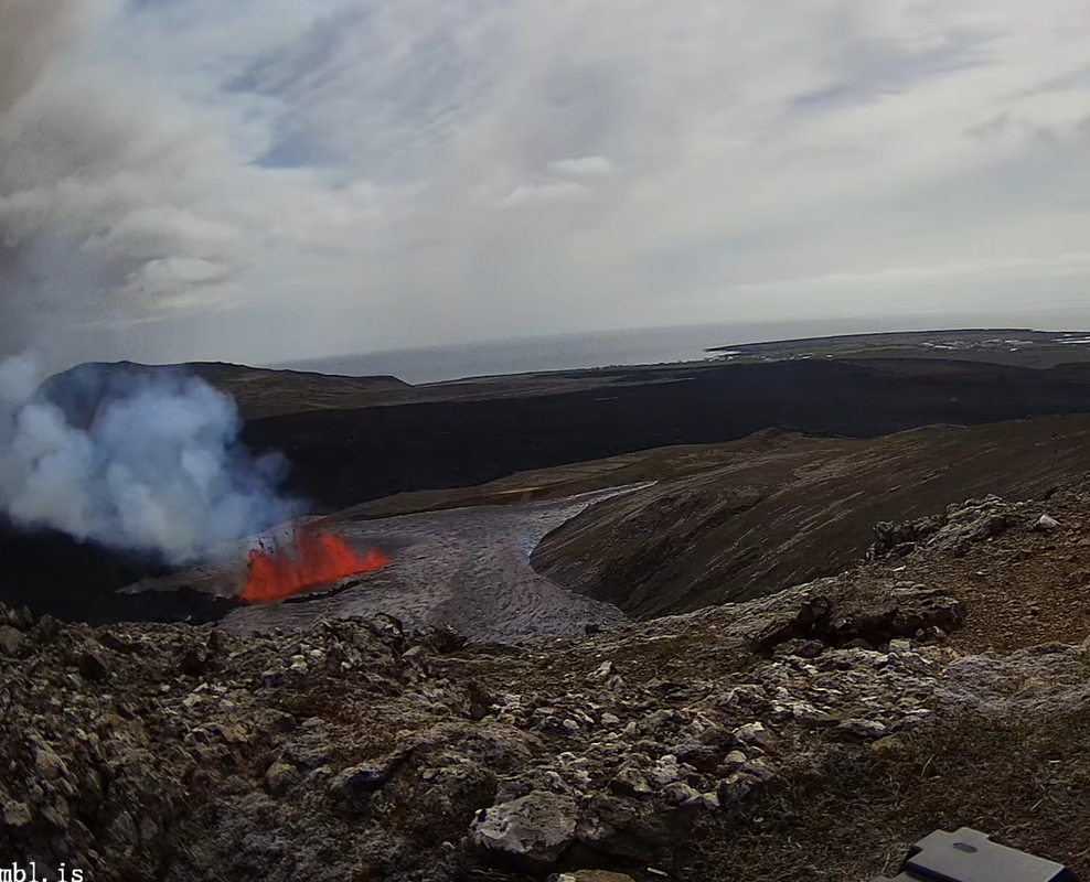
Let’s first look at the region. The map below shows the Naples area with Vesuvius, Pompei (of course) and other famous locations. The red oval shows the (very) rough outline of the overlapping calderas of Campi Flegrei.

The next map zooms in on this caldera. It shows the location of the volcanic features (old eruptions) of this region, all of which happened after the last major explosion a very long time ago. The 1538 eruption, Monte Nuovo, is number 9 on the map.

The must-have map of volcanic features of Campi Flegrei. Click on image for full resolution. Monte Nuovo is number 9. The current seismicity is centred around number 25. Solfatara is number 23, just above it.
Earthquake swarms
The earthquake activity after 2005 was initially minor, and shallow at 2 km depth or less. From 2012 it became more intense and since 2020 it has really taken off. The plot below comes from the monthly bulletins of the INGV and includes events up to April 2024 (so not this month’s swarms). It shows the rapid increase in number, and also the large increase in energy since 2023. The depth of the earthquakes remained initially around 2 km but more recently has also occurred at a depth of 4km. Much of this bradyseism, by the way, will be due to the sloshing around of underground heated water/steam. The hydrothermal system extends to 2-3 km below the surface and sees the effect of extra heat.

The swarm in October 2023 saw a M4.2 event, possibly (?) the largest Campi Flegrei earthquake for centuries. May 2024 saw this surpassed with an M4.4. (It was advertised as the ‘largest since 40 years’ but the largest one 40 years ago was ‘only’ an 4.0)
Earthquakes are mainly from three locations. One is an apparent fault in the middle of the bay, slightly curved. The second is the Starza fault along the coast, stretching from Pozzuoli eastwards. More recently, the earthquakes have been along only part of this fault, at the eastern end near Solfatara. Note that earthquakes in swarms can be hard to localize precisely.

High quality volcanic-tectonic earthquakes for the period 2005–2019. The size of the epicentres are shown as a function of the magnitude according to the legend on the bottom right. https://adgeo.copernicus.org/articles/52/131/2021/
What is the significance of the depth of the earthquakes? The events at 2 km occur at a calcium-rich cap layer. This is a thin rock cap later that separates the sedimentary layer below from the volcanic deposits (pyroclastics) above. Gasses and fluids rising from below get stuck against this cap: this hydrothermal stress bends the cap elastically and this causes the earthquakes. 2 km is about the depth where water can become steam, so it is likely that this earthquake zone is due to water vapour collecting below (and breaking through) this cap.
The sedimentary layer goes down to about 3km. Below this is the bedrock, affected by the heat from below, with another cap-rock separating the two. Since 2020, more of the earthquakes have been taking place around this deeper cap or even the bedrock below it. This may be mainly caused by CO2 degassing of magma. Magma intrusions have tended to stay within the bedrock and solidify there. The liquid magma is deeper down, at 7 to 8 km. (There is also a much deeper magma reservoir.) If magma is rising in significant quantities, it is likely that we will see earthquakes to this larger depth of 7-8 km, which we do not do at present. It is however possible that some magma did rise to 3 to 4 km in recent episodes: it has been proposed that the pressure increase was caused by the emplacement of new sills in 1950, 1970 and 1980. However, there was no proof that magma has collected at this depth – but see below.
Arise
The current activity is comparable to the events of 1983 and 1984, but with a much longer build-up to the activity. Since 2016 there has been uplift of around 1 meter at Pozzuoli (1.2 meters since 2005). The figure below shows uplift since 2021, accounting for half the total since 2016. It is focussed right at the coast, close to Solfatara. (It is interesting that the strong increase in activity in 2020 happened when inflation had recovered the highest surface level reached in 1984, although this may be just a coincidence.)

During the current inflation period, there has also been a slow change in the gas emissions at Solfatara. The fraction of CO2 over H2O has been steadily increasing, and there is also a bit more CO. This indicates that the gas emissions are coming from a reservoir that is getting a bit hotter, from 215C before 2005 to around 245C at present. There was a spike to 265C in 2020 – one wonders whether the reservoir caught covid. The temperature at which the gas reaches the surface has increased only a little, though. But the site is now considered too dangerous for tourists and it has been closed since 2019.
Plumbing
Seismic mapping has recently shown (a paper to be published in July – see references) that underneath Solfatara, the depth at which water becomes steam has grown shallower since 1984. This can be explained by an increasing temperature of the water, and provides independent evidence for this change.

Location of the reservoirs “A’, B’ and ‘C’. Locations are quite approximate, read off from https://www.sciencedirect.com/science/article/pii/S0012821X24001778?via%3Dihub#sec0010
The same seismic mapping has also shown that there are two somewhat shallow reservoirs within the caldera. One (‘A’ on the map) is located underneath the bay at some 2.5 km depth, and the other (‘B’) under land at some 3.5 km depth near Solfatara. After 1984, the reservoir underneath the bay appears to have cooled, while the one near Solfatara has grown hotter: there has been a change in the pathway used for the heating. Neither reservoir appears to contain significant amounts of magma, though. Think hot water.
As always in volcanic regions, areas without earthquake are possible carriers of magma. The recent mapping has shown such a zone at a depth of 5 km not far from the shore line, which has risen to 4.5 km depth since 2019: this is zone ‘C’ on the map. Interestingly, this zone did not exist in 1984. A possible interpretation is that perhaps 15 years ago a bit of magma migrated up and formed this new sill. This may be what has been driving the sharp increase in seismic activity since 2019.

Current events
In the last few days, there has been a strong, though fairly brief, earthquake swarm. The swarm followed a minor swarm four days earlier and two swarms in April. The current series started just before 6pm (UTC) on May 20 and culminated in the evening with a strongest reported event at M4.4 – the precise value may be subject to change. More than 150 quakes were measured. After midnight the swarm calmed down, although some events were still continuing and around 4pm (UTC) on the 21st, they picked up again a bit with a minor burst. From a report in a local news site:
The seismic swarm that has been underway in the Campi Flegrei since yesterday ‘has slowed down its pace, but it is not over yet’, volcanologist Mauro Di Vito, director of the Vesuvian Observatory of the National Institute of Geophysics and Volcanology, told ANSA.
There are no signals that allow us to say whether and for how long the swarm will continue nor whether this seismic swarm will be followed by others, but ‘given the deformation of the ground that is affecting the area it is clear that we also expect other events’, he said.
‘In the meantime, we are working to collect new elements: ‘we are making measurements of all possible parameters’ and we are implementing the monitoring network in areas that have been less neglected so far.’
All phenomena linked to the condition of the magma are also monitored: ‘gas analyzes are highlighting an increase in temperatures and pressurisation of the upper hydrothermal system, with values of the gas emitted equal to 4,500 tonnes of CO2 per day emitted by the sulphate system in locality Pisciarelli’. Similar measures have been extended in the gulf.
In the Vesuvian Observatory, meanwhile, researchers and technicians have been working for 24 hours now: ‘the staffing pace is becoming intense, there is great pressure and we would need more staff’. Many INGV researchers spontaneously went to help the workers in the Monitoring Room, where earthquakes continued to be recorded during the night with a frequency of 10 or 20 seconds.

The director of the Vesuvian Observatory Mauro Di Vito in the monitoring room of the INGV in Naples. Photo by Luigi Avantaggiato. Source: https://www.sciencefocus.com/planet-earth/something-strange-is-happening-to-italys-underground-volcanoes

Locations of earthquakes in the May 20 swarm, between Pozzuoli and Solfatara. Source https://www.ingv.it/en/press-and-urp/Press/Press-releases/5573-Campi-Flegrei-earthquake-swarm-of-20-May-2024
Future
What will happen next? That is impossible to predict. INGV is reporting that no change is being seen in the inflation rate. That already suggests this is just part of the longer term activity. There is no sign of imminent changes.
Models of the number of earthquakes suggest that we are in a regime where strain is increasing. That may resolve itself in a rupture, which can be gentle (an opening forms in the crust which lets gasses escape, as may have happened in 1984) or instantaneous, i.e. where a fault gives way in a larger earthquake. The fault is not particularly long and therefore such an event would not be that strong, perhaps M5, but a shallow earthquake of such size in a densely populated area could still be damaging.
There is no indication of an impending eruption. But of course, this caldera has history. If we get a series of earthquake swarms which are propagating in depth and location, then a dike may well be forming. Otherwise, if a fracture grows in the crust, then the hydrothermal system may find its way more easily to the surface. As the activity is close to Solfatara, the likely escape path is there. In that case, phreatic explosions may occur. It seems best that Solfatara remains closed to tourists.
Should Pozzuoli be evacuated again? That is not for us to decide! But it is a difficult one. It can only be done once. If an evacuation is ordered and nothing happens, many people will not leave next time. To evacuate half a million people may take three days. In 1538, combined with modern instrumentation, this would have given plenty of time. So it may be best not to fire off the evacuation order until INGV can see the white in the eyes of a forming dike. In that case the biggest risk is phreatic explosions which can occur without warning.
But at the moment, it is time mainly to call for calm (also for the earthquakes) and get on with life. It is what Naples does best.
Albert, May 2024
Further reading
https://www.sciencedirect.com/science/article/pii/S0012821X24001778?via%3Dihub


All the more exciting for me as Reykjanes is erupting my baby budgies are taking their first clumsy steps outside. 🙂
I showed them the eruption webcam and they were like: “Uh. Okay.” 😀
Opening more now, close to cam.
Yeah just noticed!
An en echelon jump towards the camera. This is like xmas! 🙂
Turn my back for three minutes and now there’s an offset fissure! Foreground, off to the right. https://livefromiceland.is/webcams/thorbjorn2
this cam: https://www.youtube.com/watch?v=FZmN2daZW9g
I wonder how far does it still have to go before it becomes visible on this cam looking towards eastern part of Grindavik.
Oh … only this long … 🙂
The direction this lava stream is flowing leads it to the already-filled quarry and thus likely soon passing over, reaching the road and flowing towards the west of the Grindavik berms.
If bad things happen it might overflow the berm somewhere along that route …
Impressive hang-time for the lava bombs. ~5 sec = 100+ meters.
Estimated rift length 5-7 km
Still unzipping southwards, and maybe coming yet closer to the camera?
MET helicopter inbound. WE’RE SAVED!!
It’s really racing down there
It is. 20 minutes later (compared to my shot ±10 posts upwards) it has grown to the south, with the primary vent on this cam having become very intense.
This could be bad news for Grindavik.
Those improved berms are going to get stress-tested soon…
Indeed. All that lava that came around the previous cone’s area seems to be taking a right turn, heading towards the former quarry. Plus the lava that we see in front of the southward facing cameras joining.
Do we have any cameras near Grindavik looking north?
That seems to be the best view on the southern end of the flow, looking down into the quarry.
Smoke left of the main lava flow seems like a new vent opening.
The increase in coverage on the still cams from 14.00 is astonishing
https://www.almannavarnir.is/eldgos/myndavelar/borgarfjall-sudur-sudaustur/
https://www.youtube.com/watch?v=I5JBPyrjmaE
A quite magnificent sight now for soure
Astonishing! The southward bound lava flow is crossing over an erupting fissure.
The fissure is still continuing to extend further south
This was my main concern.
https://www.youtube.com/live/-Rfk4KJgUa4?si=6MB3VMZISCRcP92l
Isak on the scene now!
Doesn’t look good for Grindavik unless slows down soon. On this camera, https://www.youtube.com/watch?v=I_wRajP-7bg if you look closely, it is obvious that several meters has accumulated within 30 minutes.
People are busy throwing up a berm across route 43. You might say a lava diversion is being put in place
IMO’s latest map of the new erupting fissures:
Unzipped a bit further south in the hour since then. Longest fissure so far. I do wonder if we should expect escalating trend as pressure slowly recovers underground dike by dike. Original dike was several times bigger than anything after judging from the inflation. Maybe by the end it will erupt in one go from the ocean to Fagradalsjall’s slope, similar to the length of that original dike that fell just short of erupting.
Summary of the latest report from the Icelandic Met Office:
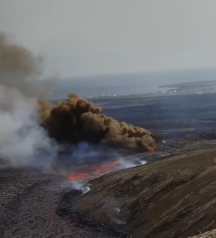
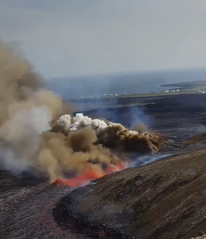
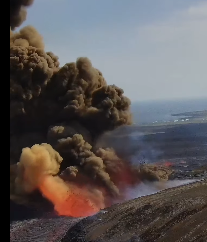
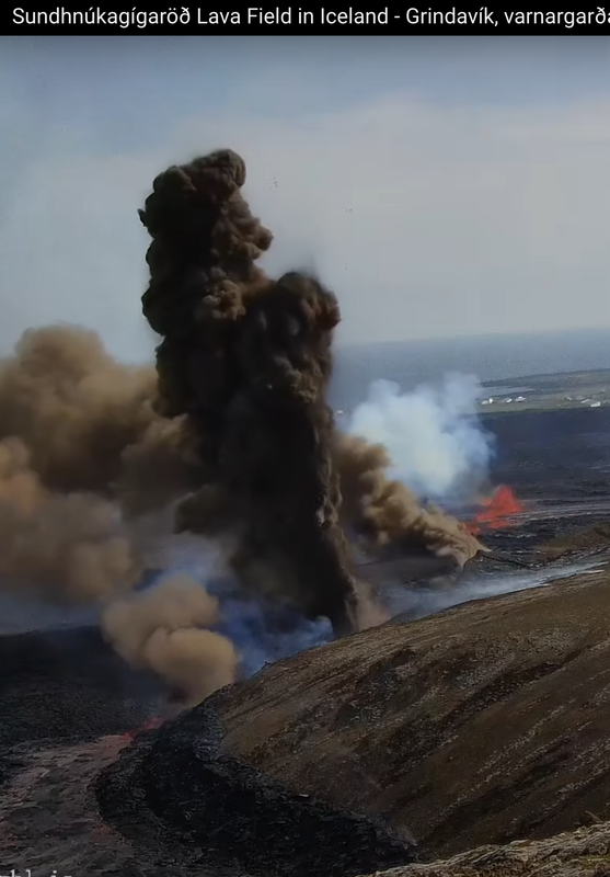
An eruption has started in the Sundhnúks crater series, with the fissure now about 3.4 km long. Lava is flowing at an estimated rate of 1,500-2,000 m³/s, primarily towards the southern end of the fissure, near Hagafell and Melhólsnáma. The southernmost opening of the fissure is less than a kilometer from the defenses north of Grindavík. Seismic activity has decreased rapidly. Gas pollution is expected to affect areas southeast and later east, potentially reaching the capital area tonight and tomorrow. The Coast Guard is monitoring the eruption closely.
Afar tv. Lava river close to homes.
This ongoing crisis for Grindavik makes me realize how lucky I was to see the remote tourist eruption in 2021. Guðshraði!
It’s over the road near Grindavik
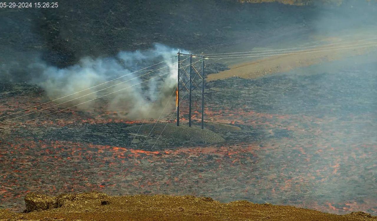
Poles are burning…
This looks so unreal:
Good thing they installed all those blinking yellow warning lights … 😀
https://x.com/volcaholic1/status/1795839177998930276
Southernmost fissure stopped erupting, or only erupting under the lava flow. Either way the eruption seems to have released its pressure and from now on it’s likely going to get less.
Seems to be billowing out ash/smoke now…
Okay … those fissures I thought were gone are now infrequently erupting more violently, emitting brown smoke.
my video seems delayed about 2 or 3 minutes, interesting
And opening again with brown smoke. What a show.
Its developing a smoking problem! But yeah, still a good bit flowing down from further north, but think that might be slowing too.
15:56 more new smoke north of the current area and pretty strong flow
Ah, that was an eruptive fissure? Now it looks more like lava flowing down a crack and reacting with water at the bottom.
New fissure opened up right as I was watching.. wow https://www.youtube.com/watch?v=FZmN2daZW9g 3:50 pm Iceland time
New, or a recovering fissure? I think these were erupting before, then slowing down and/or buried by flowing lava, and now they’re back with slightly more explosivity.
Look closer behind the smoke…
I think you’re right.. recovered activity and now huge dark brown or even black smoke clouds.
More like newer fissures showing up. May look better from a different view.
There have been fountains there for about an hour, but the brown “smoke” is new. There have been several violent eruptions of gas so I assume that is actually ash being produced.
https://www.youtube.com/watch?v=FZmN2daZW9g smoke seen very well here, it is increasing
Kapoho 1960. I guess we know where the water table is…
Must have had an encounter with groundwater ..

Wrong image, this one I wanted to post:
Now we’re talking!
These began around 15:56, first bigger explosion 15:58 and continuing through at least 16:02 …
still growing towards the north as it opens up
Sadly the battle to save Grindavik returns and with the quantity of new lava it does not look good.
It is a pity they could not remove and reassemble their buildings further along the coast.
Without the harbor there is little motive to do this, even if it was physically possible.
Hopefully some of the residents and local traders have a better backup plan this time. If this is going to continue episodically for many years staying in this zone will be impossible.
Wow i AM JUST AMAZED WITH WHAT i AM SEEING. i EXPECTED A BIG ERUPTION BUT THIS IS INSANE. lOOKS LIKE IT MAY REACH THE SEA WEST OF gRINDAVIK THIS TIME.
Sorry, capitals not intended. Hit the wrong button.
At least the text is the right way up 🙂
Hmmm?
The fissure/dyke has presumably found water?
That is certainly not effusive!
Definitely water!
There’s a real nice one at 16:20:10 shooting up straight. Camera link below.
It’s a beautiful show of black, red, and bluish clouds. No white steam, though. It might be just the gas portion of the magma taking off in a location where it’s too tall for the melt to emerge.
The fissure is still spreading towards the town.

dammit hit enter before i could write … look at the lava stream in the lower left, it seems to be disappearing into some cavity or magma tunnel unless this is just a bad camera angle
i wonder if the eruption further south is actually fed by this flow rather than erupting from deep underground
It looks like it. Also, if you rewind and check when this fissure opened up, you can see that it started at the very moment the lava flow stopped at the very location where the first fountain appeared. I wonder if this southern part of the fissure is just re-erupted lava that first drained into a crack and then hit water.
I didn’t think it could be, but https://www.youtube.com/watch?v=FZmN2daZW9g has zoomed on the channel further south and there’s nothing flowing there.


(At 16:56).
It’s shiny where lava flowed earlier but there’s nothing now. It must be going somewhere.
Cound there be an old lava tube here that has been rediscovered by the new flow? It might explain the groundwater as it would be a natural conduit for drainage from the hill the camera is on.
Then there was this at 1705, from the entry point I think:
Is the low fountaining from the exit of the lave tube under the new flow?
That explosion starts at 1703 on https://www.youtube.com/live/I_wRajP-7bg?si=5LoiHmHxsy9XFL5o
That southernmost vent, the one that’s popping off like a safety valve on a steam locomotive? Could that be a water pipe being broken by either a lave flow or a fissure opening? It’s acting different than the other phreatic vents further north.
Am I seeing an actual wide open rift, in the views pointing to the coast? Where the occasional explosion occurs?
Seen here https://www.youtube.com/watch?v=FZmN2daZW9g
Thx.
Here’s the beginning:
I missed it. …
The eruption has already been called “Philipian”.
(Congrats to the first observation in the cafe!)
Video no longer available (18:39:46 pm GMT) Can someone find a good working link? Thank you.
I knew it would start after I went back to work.
From the IMO description, it sounds like the southern end is close to the intrusive event near Hagafell. It also seems to be close to the aseismic area near Hagafell.
https://www.youtube.com/watch?v=hg5ehw5zH1M
good cam
Vogastapi view (from the north):
It looks like its crept up the hill a bit on Hagafell.
https://www.youtube.com/live/FZmN2daZW9g
A lot of ash plume.
Its interesting how the eruption started in the same place as last time and it has now become strongest right around last eruptions cone. Also interesting that it went right through the cone exactly but didnt actually follow the same fissure at all, and then raced off to the south before those fissures quickly died down and it has stayed centered on the cone.
There is still a full curtain of fire in the section north of the cone but it is low and seems to be slowly dying while the fountains at the cone are still tall. I think Grindavik might well have actually been saved by the fact the main lava flow from the cone area seems to flow into and disappear down a deep hole along a dead part of the fissure, when active the area had a lava river gushing down the steep slopes like a flash flood.
A new bit has opened up close to the Grindavik Berm. https://www.youtube.com/watch?v=I_wRajP-7bg
You need to look closely. I hope this doesn’t stretch into the town.
Are we all looking at the wrong cams? Seems that lava has already turned around the town to the west(!).
RUV (transl.) “Lava is flowing outside the defense walls at Grindavík in several places, and lava is also starting to flow outside the defense walls at Svarstengi. It tests both the parks to the west and east of the town and the parks at the US Navy’s radio station, which is northwest of Grindavík,”
Also:

Is there are webcam that looks towards Grindavik?
Bottom right here:
https://www.youtube.com/watch?v=U-tIuNuFKJo
Would be nice to have the original stream.
Sometimes its so simple!
It ist VISIR’s Grindavik view:
Thanks!
Here are close-ups:
https://www.youtube.com/watch?v=Bqudj0x0POA
If the main fountain ends up forming south of the cone from the last eruption, that might be bad news from Grindavik. This eruption might sustain high effusion rates for longer than the others while focusing on one vent.
currently the main fouintain is directly adjacent to the north of the cone. I am wondering what produces the vigorouse grey-brown smoke in the south west direction from the fountain. Looks like a vent of some kind – gas from burning asphalt?
A fascinating evolution of the view from


https://www.youtube.com/live/I_wRajP-7bg?si=pGZUVcn8A3bIXbqZ
Intially the small valley is flooded quickly from the north until it flows out:
At around 1540 the smoking begins with small outbursts:
The red patch in the above becomes the point where lava falls into the ground:
At this point it seems to have found a path underground, clearly linked to the groundwater interaction.
The path blocks up by 1703:
Until the tremendous explosion at 1704 frees it again:
At the time of writing, the flow into here seems to have stopped, probably due the fissure shortening.
This comment had more than three links, so the system automatically sent it to spam. It had to be approved manually, and that’s why it took longer to show.
When lava falls into a hole underground, does it become magma again?
I’d think that since it would have lost most of its gas it would be lava. Speaking of, I seem to remember that the lava that went back into Kilauea Iki’s vent after each episode of the 1959 eruption was never erupted during subsequent episodes. Wonder where it went?
Just like a Leonid meteor we saw years ago came in so shallow it skipped off the atmosphere and went back out into space. Meteoroid to Meteor back to Meteoroid.
All I can say now is congratulations to the courage and skill of the workers building all those berms around Grindavik. Once again they have saved the town! Well done to them all.
There is a small fissure eruption at the southmost point, quite away from the other fissure activities, will activity begin to increase here? https://www.youtube.com/watch?v=I_wRajP-7bg (around 6:46 pm Iceland time)
8 pm and the activity at the south end has increased a slight bit, with a new fountain to the right occasionally splashing up lava.
South end (Hagafell end) is going ham with groundwater interactions again, though more steam than explosions this time. I suspect things will continue to cool down, with the occasional small boom. The fissures between Hagafell and the berm have pretty much stopped, just a little bit at berm edge now.
New MET office update. They mention the crack where lava flowing into it becomes magma again, and they say this flow is what is erupting further south, just north of the berm.
There is also danger from lava flows and lava flows. I guess they had to stress that in light of the erupted 16 Mio m3 or the initial flow rate of 1,500-2,000 m3/s.
Astonishing how far the lava went on the western side of Grindavik. Maybe already crossing the street to the peninsula’s tip. Not that far from the lake … (berms work perfectly).
The hole looks like it it venting huge amounts of invisible gas that vaporises some steam to become visible once well out of the way of the hole. It looks like dancing will o the wisp!
I wonder if the magma is running at the bottom of the fissure and it’s around the depth of the water table in this area which is constantly seeping in causing the steam. And because the magma is degassing at the bottom of the fissure all we can see are the gasses and steam coming out.
Also the frequent dark could, could they be caused by the sides of the fissure collapsing and causing the magma to explode? I seem to remember that happening at Kilauea when the old vent was open ans the side collapsed. I did see on the cam the side collapse not long after the 5pm explosion. I guess the sides can’t be that stable.
Does this seem like a possible hypothesis?
Hopefully the next helicopter overflight will try and take a look at this fissure,
Actually this view https://www.livefromiceland.is/webcams/thorbjorn2 is from the side
The gas is clear as it comes out of the fissure and then turns to steam. So is it actually massive degassing somehow and the steam appearance is the water in the air being boiled to steam by the hot gasses?
Steam is actually clear; the white part is when it cools and becomes water vapor.
Ah so I’ve got it the wrong way around. Thanks for putting me right.
There must be a lot of water down there. The sea?
Isak has a drone flight over the eruption
(also to Grindavik?)
no he was stuck not far from the previous cone and unable to fly the drone to the grindavik direction – I think flight altitude restrictions plus mountain/hill in the way, good footage of the northern section eruptions though. Very fluid fast moving flows, good fountaining etc.
Fascinating.
I’m beginning to see a pattern here.
Not trying to make too much of it but … anyone else noticed how perfect the weather conditions were for each new eruption?
Despite the often terrible weather over several days prior to the eruption.
This can’t really be coincidence, can it?
Perhaps … none of this is real?
Maybe it’s just one grand lie and we’re merely watching CGI so we’re less likely to vote. 😉
You should know about all the eruptions we missed in the fog and rain! Don’t tell anyone.. Anyway, the rule is that eruptions only happen when the Blue Lagoon is open.
Looks like activity to the south picked up a bit again.
Definitely picked up to the north of the old April cone.
Grindavik is practically inaccessible now. They can build over the lava of course but these flows to the west are quite wide.
It appears that the only way in to Gridavik now is from the east, that is a Huge diversion! Plus with the fire on the lectricity pole and the lava flooding over the road again then most likely no electricity and possibly no water either.
You can still enter it from the east but that would be quite the detour coming from Reykjanes.
And then you have to be sure the wind is blowing to the west. Your lungs will thank you for it!
One of the fountains south of last eruptions cone restarted and a lot of the fountains north of there have declined, seems to be determined to reuse this spot just apparently not enough to commit when the opening stages are going 🙂
I think its pretty clear though that the eruptions will always be fissures at the start, trying to get 2000 m3/s to erupt out of the cone last time would probably make a fountain tall enough to see from Akureyri. I think we all lost the sense of scale in those 2 months, the cone was completely dwarfed by the fountains near it.