![]()

Adventure begins at Mount Schanks
When a nanny descends from the sky hanging from an umbrella, you know Mary Poppins has arrived. It may be the second best movie to watch at Christmas. (The most popular one remains the Muppet Christmas Carol.) Mary Poppins comes to take care of the children but ends up changing the grown-ups more. Even the most dour of bankers learns from her to laugh at the world. Fun explodes like a rhyolitic volcano. The most memorable bit of the movie (apart from some highly dubious accents) can be summed up in one word: “supercalifragilisticexpialidocious”. It means whatever it needs to mean. The word is much older than the movie. When first invented around 1930, it was a complicated way to say ‘splendid’. Later it was listed as having no meaning, apart from being the longest word in the English language. (In fact, it is the 5th longest.) In Mary Poppins, it is used as something to say when you have nothing to say. (Useful for Twitter, but you might run into the character limit for saying nothing.) It rhymes with ‘atrocious’, as used in an infamous UK headline when a major football team (Celtic) was beaten by some minnows from the Highlands, a merger between Caley and Thistle. “Super Caley Go Ballistic, Celtic are Atrocious!” wrote the Scottish Sun. (Yes, that newspaper title may be a contradiction in terms.) Mary Poppins turned not only the people upside down, but also the language.
What makes a good Christmas movie? Perhaps it is the same thing that makes a good Christmas: a family coming together. For just one day we can forget about the pressures of normal life, the need to be best or at least first, and enjoy each other as a company of equals. At heart, we are all socialists: whether democrat or republican, tory or labour, left or right, we need others around us, talking, doing, living together. This is the one day of the year we can enjoy the happiness of just being at home with others. This is the ultimate socialism, the original meaning of the term. It is the one day of Mary Poppins.
Let’s turn the world upside down and look at volcanoes that way. This is about the living volcanoes of the oldest of continents: Australia, and about the stories that were told over countless generations of family gatherings.
Victoria, Australia
It is a few hours drive west of Melbourne if using the main road. Don’t. The spectacular coastal route, known as the Great Ocean Road, takes rather longer but is far more fun. While we meandered along it, the views alternated between the sea and the land. The winter landscape (it was August) was green, with patches of tall, dripping rain forest amidst the farming, mixed with the cliffs and waves at the coast. It didn’t look like Australia should.
After an in-land detour and a tree-top walk in the forest, we arrived back at the coast. Spectacular, steep limestone cliffs were fighting off the waves from Antarctica. A viewing platform showed us a number of tall but fragile looking rock stacks, called the Twelve Apostles. One of the stacks was missing: it collapsed a number of years ago leaving only 8. (If this seems to call into question Australian mathematics, the Twelve Apostles is a name, not a number.) As darkness fell, most of the other tourists went back to the small car park. They left too quickly. In the growing winter darkness, brown shapes emerged from the sea below and waggled their way up the beach. They were little penguins which live here year-round. We watched them until it became too dark to even see the beach and waggled our own way back to the car.

The Apostle rock stacks were formed by coastal erosion. They are where the coast used to be but was beaten back by the storms. The rocks and coast are limestone, easily eroded by the Antarctic waves. The limestone is grey, in effect carbonate sand. It was deposited in an ocean some 100 meters deep, between 14.5 and 10.5 million years ago. It started during the Miocene climate optimum (yes, that is a name) and continued while the climate had begun to slowly cool and ice grew in Antarctica. The limestone layer is up to 240 meters thick. It includes some pollution from volcanic material which was slowly becoming more felsic over time. Volcanoes were at large, somewhere to the east.
Above the limestone is a layer of clay, the Hesse Clay, and a layer of sand, the Henson Plain Sand. They show that the area was changing. The land was rising as new mountains were building to the north. The shelf where the limestone had formed was now approaching sea level and 5 million years ago, became land. Rivers build up a fluvial plain of sand. Temperate rain forests started to grow. The clay and sand contain volcanic ejecta, in proper Christmas fashion fallen from the sky.
But nothing volcanic was visible from our viewing platform. The little penguins spend the night undisturbed on the beach – they came on-land for safety, not for eruptive entertainment.
Driving back we took the in-land road. The vegetation changed: the green, undulating landscape looked quintessential English, seemingly far too fertile for Australia. The cloudy weather also looked like England. We passed towns and lakes. On the edge of the town of Camperdown a green, steep, cone-shaped hill appeared. A narrow road took us to the top, through the small open forest on the slopes. The summit formed a semi-circular ridge half surrounding a deep depression. The hill, called Mount Leura, was clearly volcanic in shape. It is in fact a 130-meter-high scoria cone with a large central crater. Part of it is (optimistically) called Sugarloaf Mountain. The view showed small bumps surrounding the peak. In the distance were other cones, in seemingly random directions. A small display provided their names: Mount Shadwell, Mount Ewan, Lavers Hill. This land was littered with volcanic remnants, eruptions of yesteryear.

Mount Leura erupted only once, 160,000 years ago. It was an eruption in phases, which moved around a bit. After the cone had build, an explosion formed the crater and breached the cone in the process. More, small peaks formed around it, partly merging into a volcanic complex. And then everything ceased. The mountain had been quiet ever since. A long time after, people arrived, build their camp on the edge of the hill, and told stories about how this solitary mountain came to be, and about the spirit hiding within it.

From the summit of Mount Leura. Photo by the author
The scattered cones give the impression of isolated eruptions. In fact, these eruptions here were far larger than the cones that they left behind suggest. Look beneath the surface, and signs of lava are everywhere. A basaltic volcanic province appears. It may not be a proper flood basalt, but it certainly is a member of that family. It has a story to tell.
![]()
Newer Volcanics Province

Australia has far more volcanoes than it gets credit for. Many are found near the east coast. The youngest ones are in the Northwest Territories and here in Victoria on the south coast of Australia, both with possible eruptions in the last 10,000 years.
The young volcanic region in Victoria we had traveled through on that winter day is called the Newer Volcanics Province. (In Australia, anything younger than a few million years counts as ‘new’.) It extends westward from Melbourne to Mount Burr, a distance of 400 kilometers and covers an area of 23,000 km2. Australia doesn’t do small! The landscape is smoothly undulating farmland interspersed with lakes (of all sizes) and stony ridges. Isolated steep hills suddenly rise from the farmland, looking like someone dumped them there. They, of course, are volcanic. But so is the farmland.
The entire region is covered with basaltic lava flows, top to bottom. The hills or cones are just the tip of the iceberg, the acne of a volcanic surface. The farmland appears smoothly undulating because the lava flows have filled in the original valleys. Some of the lava is ancient and fully weathered. Other flows are younger and still rough, forming stony ridges in the landscape that can be difficult to cross. In places, thin scoria layers have been dumped on the land.
It is called an ‘intraplate continental basaltic volcanic province’. These are not uncommon: every continent has them. They tend to be long lasting, lack central volcanoes but instead have many different eruption sites each of which is short lived. Each province can have hundreds of such volcanoes. Eruptions occur infrequently, thousands of years apart (or more) but they can pop up anywhere within the province and at any time. The eruptions form large lava flows, scoria cones, maars, tuff rings and volcanic complexes.
The Newer Volcanics Province has 416 known eruption centres with 785 known eruption sites: about half the eruption centres are ’complex’, meaning that they erupted from more than one location.

Photo by Don Fuchs https://www.australiangeographic.com.au/wp-content/uploads/2018/06/IMG-388.volcanoes.VIC_.Mt_.Napier.sunset.jpg
The individual cones can be hard to date. They are deeply weathered – even Australia has weather! But some cones appear recent, pleistocenic, perhaps even holocenic. In fact, five eruptions have been dated to within the past 100,000 years and 2 to within 10,000 years. The youngest are around 5,000 years ago.
The eruptions began 4.5 million years ago, during the pliocene. There was an earlier phase of volcanism 7-6 million years ago but that seems not directly related to the Newer Volcanics Province: they included felsic magmas while the later volcanoes were exclusively basaltic. The Newer Volcanic Province likely started north of Melbourne and over 4.5 million years slowly extended westward. The oldest eruptions were more often inland, especially towards the northeast. The youngest are often nearer the coast, especially in the far west of the region. But in reality volcanoes of any age can be found anywhere. The maars are mainly in the southern part, where the rising magma had to pass aquifers. Just south of them there is a sharp cut-off: no volcanoes exist south of this line.

Photo by the author
The volcanoes tend to cluster around known fault lines. These may provide convenient paths for magma transport from depth.
The volcanoes
There are too many to list. The highest scoria cone is Mount Elephant with a height of 240 m. Mount Rouse, 285,000 years old, is the largest by volume. Its double scoria cone is about 100 meter high and is breached on one side. Two craters are located just outside the cone. Eight eruption points have been identified. The eruption here produced lava flows that reached Port Fairy – 60 km away! Lava tubes were needed to carry the lava over such a large distance. The lava covers an area of 450 km2. The total volume is in excess of 1km3. This combination of lava and scoria is common for the area.

Mount Rouse with the double scoria cone and two smaller cones on the right. Source: Boyce et al, 2015
Red Rock is an example of another type of eruption. This complex includes both maars and scoria cones, covered an area of 7 km2 and includes at least 40 different eruption sites. It formed on top of an older lava flow. There are nine lakes which formed in at least 18 separate explosions. These maars formed in an early phreatomagmatic phase. The 22 scoria vents mostly formed later, when lava could reach the surface unimpeded by water. Red Rock is the most complex of the known volcanic sites of the Newer Volcanic Province. It is surprising to see scoria cones, maars and a lava shield all from the same eruption and within 1 km of each other.

Red Rock Volcanic Complex, looking like an oversize golf course
The Mount Gambier volcano (not to be confused with the town of the same name, situated on its edge) consists of a cone with a large crater, and a separate maar called the Blue Lake. The colour is seasonal: in winter the lake goes grey but in summer it indeed becomes a dazzling blue. The main eruption has been modeled as an explosive VEI 4, at 0.3 km3. The explosion occurred when the rising magma met the ground water: it ejected a cloud 5-10 km high and closed the airspace over Melbourne for days. Not that that mattered as neither airplanes nor Melbourne existed at the time.

Mount Gambier
(Whether Father Christmas would be affected by the airspace closure is not yet known. Studies are ongoing to measure the effect of airborne ash and sulphate on flying reindeer.)
![]()
Stories

Photo: Wayne Quiliiam
Australia has been occupied for a very long time, and by the same people. The oldest evidence for human presence in the Northwestern territories is dated to 65,000 years ago. Southeast Australia was reached 40,000 years ago. Unlike the rest of the world, it seems there was a remarkable continuity, with the same groups remaining in one region for the entire period, each with different cultures and languages. Once settled, they did not easily migrate. Any people who remained this long must have been very well adapted to their environment. Knowledge was passed on effectively between the generations. This was done through the oral tradition called the ‘Dreaming’ which included stories, traditions and practical knowledge. Any unusual event was retold and remembered. Over 10,000 years or more, rare events will return: a long memory helps to know how to survive them. The recollections and advice needs to survive far longer than living memory. “For when you dream, you’ll find all that’s lost, is found.” – Mary Poppins.
Direct evidence that humans were present during eruptions is sparse. A post hole that was was sunk near Tower Hill serendipitously uncovered a stone axe, buried 1 meter deep below a layer of stratified tuff. It is now called the ‘Bushfield axe’, and proves that humans were in the area before or during the eruption. The ejecta have been dated using radioactive decay to between 34,000 and 40,000 years ago. A large lava flow from a hill 40 km away, Budj Bim (Mount Eccles), was dated to approximately the same time. There have been no other eruptions in the region since. Human presence (and their axe) goes back a long time here.

From Wilkie et al. 2020
Indirect evidence for human presence during eruptions comes from Aboriginal stories passed on through the Dreaming. There is a term for it: Geomythology. Robert Smyth, in the 19th century, reported that “The [Aboriginal Australians] point to some of the recently extinct volcanoes, and say that fire came from them once.” He also wrote that the Aboriginal Australians used the term Willum-a-weenth for these hills which once had smoke and steam. ‘Willum’ can be translated as dwelling place, and ‘weenth’ is a word for fire.
Stories exist about Mount Leura too. A 19th century report states that “when some of the volcanic bombs found among the scoria at the foot of Mount Leura were shown to an intelligent Colac native, he said they were like stones which the forefathers told them had been thrown out of the hill by the action of fire.” This mountain last erupted 100,000 years, long before Aboriginal Australians arrived in the area. The association of such stones with fire came from other mountains.
There is a word ‘kulur’ which is widely used for places across the volcanic plains. The word means ‘very hot’ or ‘burning’. It is sometimes translated as ‘lava’. The word is attached to places such as Mount Sugarloaf which was known as Kulorr-Kulorr (‘lava stone’), and Mount Rouse. These mountains have not erupted in the Aboriginal Australian era but the type of stone was apparently known to come from fire, just like we can recognize solidified, stone-cold rock as lava. The Stony Rises, old lava flows, were known as ‘Kurt baulen’ or ‘stone islands’ and as Kullorr maleen meaning ‘lava islands’.
Aboriginal stories tell about mountains throwing stones at each other. The mountains that are involved change: a similar story is told about several different ones. In one version, it relates to Mount Buninyong and Mount Elephant throwing stones at each other ‘in a fiery wrath’. Another version has Mount Franklin throwing stones at Mount Tarrengower. (The latter is not volcanic.) If there is an event behind these traditions, it has become attached to the wrong mountains as none of these have erupted within the past 100,000 years. The stories are always about local mountains, and explain how the landscape around them came to be.

But which eruptions could be at the origin of the stories? Only four are known within the Aboriginal Australian era: Mount Gambier, Mount Schank, Tower Hill and Budj Bim. The first two form a pair, located in the same (western) region and erupting within 1000 years or so, possibly simultaneous. The last two are further apart, but are both in the central region.
The Aboriginal name for Tower Hill was Koroit, meaning ‘place of fire’ or ‘smoking, hot ground’. (Different sources do not always agree on the precise translation of the many Aboriginal languages!) There were several reports in the 19th and early 20th century that the local Aboriginal Australians talked about this quiet mountain once emitting fire, ashes and streams of molten stone. According to their tradition, their ancestors had seen burning mountains there. Budj Bim shows up in the earliest stories, about the creation of their world. In those stories, the low hill of Budj Bim represents one of the four ancestral beings; lava spat out as it burst through the ground. They also refer to the “land and trees dancing”.
Did they really pass on memories of an eruption that happen 37,000 years ago? It would be by far the oldest story in existence among any human population! The Bushfield axe shows that there were people in the Tower Hill area at the time. Who they were, and whether they were the ancestors of the later population is something we can only guess at. Extreme cultural continuity would still be required, with the people continuing with their way if living while the world outside went through the depth of the ice age and the holocene after this, and spread around the globe. When the eruption occurred, all of America was still Terra Incognito. Oral traditions can survive for a long time, even in our transient western culture. Our fairy tales paint a strange world where witches have power, forests are dangerous and wolves are a threat. Those tales are older even than our language and have migrated with our ancestors across Europe. Rumpelstilskin may be 4,000 years old and Jack and the Beanstalk 5,000 years. Different versions of the latter show that the latter predates the east-west split in the Indo-European language. Perhaps a culture as stable as the Aboriginal Australians could hand down their stories ten times longer than the rest of us. Further north, in Queensland, Aboriginal stories recall changes to the landscape that we now know happened more than 7,000 years ago. It is possible. “Let the past take a bow. The forever is now.” said Mary Poppins.
But the memories may not necessarily have been from Tower Hill and Budj Bim. The stories about mountains throwing stones at each other clearly became attached to different mountains – people had forgotten the actual locations. Names change and this can confuse the stories, or people move to a different area and the story has to move with. (People have even searched for Noah’s ark on Mount Ararat, not knowing that Ararat referred to a different region in those days.) The stories about an erupting mountain came without a clear description of which mountain. When people saw signs of past eruptions around a mountain in their region, which fitted the descriptions, it was tempting to associate the stories with that mountain. The jury is out: the memory may not be quite as old as the mountains.
But that still means that some eruption must once have been witnessed, to provide an origin for the stories. That brings us to the two youngest eruptions, Mount Gambier and Mount Schank, located on the western end of the Newer Volcanics Province.
There are two stories which relate to it. One comes from the region near Portland which is 80 kilometers to the southeast from Gambier. Aboriginal stories in this region recalled a tsunami: long ago a great wave came to Portland, destroyed an isthmus, overran the beach and devastated the land and forest beyond. A large tribe was almost wiped out and only a few members survived to tell the tale. The story says that ‘when Mount Gambier begins to burn, and the earth to shake, the tidal wave will come again’. Tsunamis on the Victoria coast are very rare. Tsunamis from earthquakes in the Pacific (Tonga, Indonesia, Chile) don’t normally reach beyond New South Wales. In the story, the tsunami was specifically associated with Mount Gambier. But Mount Gambier is 15 km from the sea. Mount Schank is located between it and the sea and is perhaps more likely to have caused a tsunami but even it seems rather far to move the sea. There is another possibility. In this area, the steep edge of the continental shelf is very close to the coast, with a deep basin beyond. An earthquake could cause a large slide on this edge, and thus trigger a tsunami. Earthquakes are uncommon in the New Volcanic Province, but there have been a few small ones south of Mount Gambier, at the edge of the continental shelf. And the story did associate the eruption with ‘shaking’, suggesting a large earthquake.
The second story is much harder to interpret. It tells of Craitbul and his family, who lived on Mount Muirhead where they would collect roots and roast them in ovens underground. One night they were woken by the shriek of a ‘bullin’ bird. The family fled to Mount Schank, but one night the same happened there. So they fled to Mount Gambier and lived in peace for a long time. But one day water came up in their oven and put out the fire. This happened four times, in four different ovens. The story mentions that they fled from an evil spirit called ‘tenneteona’, a word similar to the local word for lava.
The story is interpreted in different ways. The ‘ovens’ may be the volcanic craters. The maar craters around Mount Gambier do indeed periodically fill with water. But what is the ‘bullin’ bird? Suggestions include the noise of boiling water, or fumaroles. The spirit they fled from could have been the ground becoming too hot. Mount Muirhead has not erupted for more than a million years and may be a case of mistaken identity in the story. Does the remainder talk about the eruption of Mount Schank 5,000 years ago, and was there an eruption from Mount Gambier afterwards? It is far from obvious. The story says that tenneteona appeared not to exist far from the coast which is why the family moved to Mount Gambier.
Mary Poppins would have taken us into the story and show what really went on – with song and play. Her guidance is badly needed. We can take the story as a warning about the dangers of those mountains and their craters. The association of lava with proximity to the coast may represent a true recollection: three of the four holocene eruptions have been close to the coast. But this story is unclear. The previous story was far more direct about Mount Gambier having erupted a long time ago.
The stories indicate that the people knew about eruptions and could recognize rocks and features that were caused by eruptions, by explosions and lava. This is not unique to Victoria. Queensland has had eruptions 7,000 years ago, and the Aboriginal Australians there recall the lava, the ash clouds, and small phreatic explosions. They mention later steam clouds, terrible to see but not dangerous. The traditions focus on smoke, fire and heat and sound. Myth is not about memory. It is about experience.
In our fast-changing world, we forget how powerful words can be. The stories we tell at the family time may be passed on over generations. Whilst tweets are fleeting, stories can last forever. It is sobering to think that the Aboriginal Australian’s memories may have been passed on for more than 1000 generations, ten times longer than the oldest memories in our bible. “Everything is possible” says Mary Poppins.
But that ancient link is now broken. Many of the traditions and stories became at risk when the Aboriginal Australians were banned from speaking their own languages and their families were broken up. Cultural continuity ceased and invaluable information about the past was lost. The stories above were mostly reported in the 19th century, before the cultural vandalism. Those reports, and one stone axe, are all that remains. It is a massive loss not just for science, but for humanity.

Cave painting
![]()
Volcanic causes
There are stories behind the stories. Science too is a form of Dreamtime. It poses questions, searches for answers and tells the results for future guidance. (Future use is harder if the research is published behind a paywall!) “Enjoy the adventure. Don’t spoil it with questions” said Mary Poppins. She may have been practically perfect, but she was wrong on this one.
The cause of an intraplate volcanic province can be difficult to determine. The obvious explanation of a hotspot trail doesn’t work. The Newer Volcanic Province shows no age sequence, and the westward extension over time is not in the direction of plate motion. It seems that its volcanism is not tied to a location in the deep mantle. We have to look elsewhere.
One idea is that is the fault of Antarctica. When Australia split off from Antarctica, the thinning of the crust and rifting allowed warmer material from the upper mantle to rise up. A somewhat similar idea is that Australia is moving so fast (7 cm per year) that the lithosphere can’t keep up. The different speeds set up convection, where the lower lithosphere finds itself falling behind and rises up behind the steep edge of the thick continent. This edge convection sets up a warm layer which is following Australia.
What these ideas have in common is that they apply only to Australia. Intraplate continental basaltic provinces occur on all continents including Antarctica. It would be nice to have a more common explanation. We are still searching: the cause of these provinces remains in question. Maybe Mary Poppins did have a point. What the provinces have in common is that volcanism is very long-lived, intermittent, widely dispersed but remaining within the same large area of the continent, where the magma composition can change over time or differ per location. The volcanoes are monogenetic, meaning that after an eruption episode the conduit has time to fully solidify and closes for further business. The volcanoes probably erupt for days to months, rarely longer. The individual lava flows are mostly small and thin, certainly compared to flood basalts, but can also extend 50km or more. They are the most abundant type of volcanoes on Earth and yet remain the least understood!
The Newer Volcanic Province is probably the largest one currently in existence. The volcanic field extends slightly off the coast with evidence for some submarine eruptions. The Province has been going on for a long time: at one location, 28 lava flows have found on top of each other, one per 100,000 years or so. The oldest data lava in deep cores is 4.5 million years old. The landscape has been completely changed by the volcanic activity. Some of the numerous lakes are maars, while others formed when rivers were dammed by the lava flows. Valleys have been filled in by lava and ejecta.
Some of the maars are very large, up to 3 km. However, it appears that this does not reflect the explosion size. Instead each were formed by a number of smaller explosions which enlarged the crater. Typical eruption sizes for each volcano are VEI 3 to 4. Mount Leura is around 0.3 km3, as is Mount Gambier.
The amount of lava that is produced is highly variable. Both Mount Schank and Mount Gambier produced little lava, but instead had much more violent explosions which covered the area in extensive air-fall tephra.
The location of the individual volcanoes seems to relate to nearby faults. For instance, the vents of Mount Gambier are aligned with a nearby fault. These faults seem to allow the magma to migrate upward. The picture that emerges is that of a ‘leaky field’ where magma leaks upward over a wide area through any holes that become available, each volcano like the chimneys of Mary Poppins’ London. The type of eruption depends on details of the local environment of each chimney. “Anything can happen, if you let it” – Mary Poppins.
The relation to local faults can cause the eruptions to be along short fissures. This is evident in Mount Schank. It’s eruption appears to have started with fountaining along a 3.5-km fissure, followed by the maar-forming explosion to the south.

Stories being written down about Mount Schank. The dark lava is covered by up to 8 meters of pyroclastic ash, filling in the irregular lava surface. Source: Cas et al.
Evidence for an origin in the upper mantle comes from xenoliths: mantle inclusions in the lava, sometimes several centimeters across. Magma from Mount Rouse was found to have come from a depth of around 55 km, at the base of the lithosphere; it had collected there in small pockets. At least three separate batches with different compositions contributed to its eruption. It sounds a little like the Reykjanes peninsula.
The question remains, why is the Newer Volcanic Province here and why is it here now? If it is caused by the location at the trailing edge of Australia, why did it only develop in the past 5 million years? Why the sharp southern boundary along the Colac Lineament? And where does the mantle warmth come from? None of the earlier suggestions seems to explain all these features: hot spots don’t work and edge convection works much too well.
It has been suggested that the true driving force is tectonic: the stress that the movement of New Zealand is putting on Southeast Australia across the distance, perhaps transferred via the Tasmania fracture. This would explain the location and stability of the Newer Volcanic Province. A separate explanation would still be needed for the warmth in the region. Edge-driven convection might do that. Large events such as volcanic provinces may need more than one cause to come together. They are geological accidents, or for volcano hobbyists, Christmas come early.
But perhaps we should just enjoy the scenery. As Mary Poppins would say, “Why complicate things that are really quite simple?”
![]()
The next eruption
It is very unlikely that we will personally see another eruption here. The average time between eruptions is something like 15,000 years. However, if it did happen what would we see? What would we tell our children at the family Christmas gatherings, to impart the knowledge of what to do in future events? “What’s to happen all happened before” confirms Mary Poppins.
All eruptions have a lead-up time and a trigger. In the Newer Volcanics, the lead-up can be viewed as the growth of a magma pocket. The trigger is something which allows that pocket to migrate up. As faults are involved, a plausible event would be a tectonic earthquake. The growth of the magma reservoir may be imperceptible if it happens too slow and in a region ductile enough to avoid any earthquakes. For the trigger, movement on a fault would be an obvious choice, especially since most of the region is seismically quiet – at normal times. A larger earthquake would be followed by episodes of small swarms as the magma finds pathways. No conduit exists, so rock-breaking earthquakes follow as a dike feels its way towards the surface. Finally, possibly after a quiet phase, the eruption begins. It could happen anywhere in the province. The onset may be explosive if the location is above an aquifer. It may be a small fountaining fissure. A new cone grows but stops after a week or so. An adjacent location erupts, and now may produce lava that feels its way around for a way to the sea. The flow extends for kilometers, may be much more, but it doesn’t get to the coast. After a month or two the flow ceases. The process repeats a few more times in adjacent locations but every time it is less energetic than before. Finally the eruption ends, but the explosions do not: hydrothermal explosions continue in the area for some years. There is damage and destruction, of course, but unless the initial event is in a build-up area (for instance Camperdown) the impact is limited. Melbourne gets a two-day dusting with ash and the airspace over southern Australia is closed for a week or so. After that, the tourists flock in.
Where would it be? Anywhere, really – that is the nature of these provinces. They are unpredictable; past locations are no guarantee for future performance. Think of it as a Christmas present. Based on the more recent eruptions, a location within 20 kilometers of the coast seems more likely. But there is another area where geothermal heat maps suggest the presence of magma pockets: near the town of Bendigo, northwest of Melbourne. There is nothing that suggests an eruption is likely here. It is just one of many places to keep an eye on. We are a bit like the chubby little fellow with flying reindeer, looking for the right volcanic chimney.
It is all guess work, of course. Volcanism in the region is varied and unpredictable. There should be monitoring in the region, just in case a build-up is happening. It is plausible that magma is already lying in waiting underneath many locations, held back by a lack of earthquake triggers. This is, after all, a quiet, seismically sleepy region.
Any maybe that is the final secret of the Newer Province. It was always at risk of eruptions, but the Province only burst to life when something destabilized the crust and opened the faults. What really happened, 5 million years ago? That, I am told, is another story.
Albert, 25 December 2022
![]()
Sources:
Erin L. Matchan et al. Early human occupation of southeastern Australia: New insights from 40Ar/39Ar dating of young volcanoes. Geology, 48, 390–394 (2020)
Benjamin Wilkie at al. Volcanism in Aboriginal Australian oral traditions: Ethnographic evidence from the Newer Volcanics Province. Journal of Volcanology and Geothermal Research, 403, 10699 (2020)
R. Cas et al. The dynamics of a very large intra-plate continental basaltic volcanic province, the Newer Volcanics Province, SE Australia, and implications for other provinces. Geological Society, London, Special Publications, 446, 123-172 (2016)
Julie Boyce et al. Variation in parental magmas of Mt Rouse, a complex polymagmatic monogenetic volcano in the basaltic intraplate Newer Volcanics Province, southeast Australia. Contrib Mineral Petrol, 169, 11 (2015)
From all of Us to all of You: VC wishes all you readers a Merry Christmas, and a Hunga Tonga 2023!


Some previous Christmas posts

And a Happy Christmas everyone!
Merry Christmas and many more of them.
Thank you
🎄🎄🎄🎄🎄🎄🎄🎄🎄🎄🎄🎄🎄🎄🎄🎄🎄 🎄🎄🎄🎄🎄🎄🎄🎄🎄🎄🎄🎄🎄🎄🎄🎄🎄 🎄🎄🎄🎄🎄🎄🎄🎄🎄🎄🎄🎄🎄🎄🎄🎄🎄 🎄🎄🎄🎄🎄🎄🎄🎄🎄🎄🎄🎄🎄🎄🎄🎄🎄 🎄🎄🎄🎄🎄🎄🎄🎄🎄🎄🎄🎄🎄🎄🎄🎄🎄 🎄🎄🎄🎄🎄🎄🎄🎄🎄🎄🎄🎄🎄🎄🎄🎄🎄
Fantastic article, Albert. Thank you! And Merry Christmas and Happy New Year to all on the Cafe! 🙂
You might want to add Mt Napier and Red Rock craters to the list of eruptions people saw. Napier is about 32,000 years old, Red Rock craters is some 8,000 years old by all sources I can find on it, which would make it a Holocene eruption and about 3000 years older than the eruptions at Mt Gambier. The eruption frequency is probably higher than your estimate of 15,000 years 🙂 although I agree an eruption in the next century is still not much more likely either way.
You mention the eruption that is from Kinrara volcano, 7000 years ago in Queensland. The Toomba volcano was also seen by people 13,000 years ago, and both it and Kinrara were massive, lava shields of multiple km3, with Kinrara having a massive paroxysmal stage at its end that was of comparable scale to Holuhraun, serious scale volcanism. Lakes Barrain and Eacham in the Atherton province are also young enough, being under 20,000 years old. All of these areas are young and will erupt again or nearby too. Adding these actually does give some statistics of an eruption being not terribly unlikely this century although nothing more than that.
Also the crust underneath both the Newer Volcanics and the north Queensland volcanism is very thin. Australia is known for its ancient cratonic crust but the east coast has seen rifting in the Cretaceous or later and is only 20 km thick, which is thinner than parts of Iceland. The total lithospheric thickness is some 50 km on the east sode of the Great Divide. It is most likely that all the volcanism in Australia in the Cebozoic is related to this thin crust, the hotspot might be real but seems is not really the primary driver, especially given the two presently active areas are at opposite ends of the continent… 🙂
(hopefully the picture is not too big)
Mount Napier is the 5th eruption of the past 100,000 years, but is perhaps a bit early to be seen by humans. It is dated to just below 50,000 years and there is no evidence for human presence in the south by this time. The age of the Red Rock is based only on an exposure age and is not reliable by itself.
Is there a source of that age for Mt Napier? All of what I could find is that the lava flow it created in Harmans Valley is dated to 32-33,000 years ago, there is mention of one age of 45,000 years but an extreme older end not a mean.
https://www.google.com/url?sa=t&source=web&rct=j&url=https://www.hamilton-field-naturalists-club-victoria.org.au/images/pdf/Publications/Geology/VolcAgesKG.pdf&ved=2ahUKEwiO8Mqeipb8AhWO1jgGHbDGAnsQFnoECBUQAQ&usg=AOvVaw1296c1DG97P6JuZHBB1hEE
It also should be noted, the exact age that people first arrived in Australia is controversial. Dates of older than 65,000 years are not proven but far from implausible.
There is also this site, which is of quite direct relevance to this article 🙂
http://www.moyjil.com.au/how-old
Your age for the Harman flow is a ‘cosmogenic exposure age’ which measures how much production there has been of elements produced in the atmosphere. Two different studies found the same age from this. However, these ages appear systematically too young, probably because at times the measured flow was covered in vegetation or even water. A radioactive decay age for this flow is around 45,000 years: Oostingh et al. 2017 (sorry, behind a paywall). They measured three samples and found similar ages for all three.
I also found an age for Red Rock: 110,000 years, but the authors caution it should be considered as an upper limit..
Interesting. There needs to be more access to this stuff. When I went to some of these places (Mt Leura, Tower Hill, Bunj Bim abd Mt Napier off memory) the local areas were quite insistent on them all being pretty young. Both Bunj Bim and Tower Hill had some interesting data at their information boards, it included a roughly accurate age (23,000 years for Tower Hill, 45,000 years for Bunj Bim) but also gave a second Holocene age for part of both complexes, as in that a second eruption had occurred. Where that came from I have no idea and it isnt mentioned anywhere online, but at the same time the data was not presented in a way that looked like a wikipedia article that had not been assessed yet…
It is looking like the next Australian eruption will be up in Queensland. Atherton has some young maars of late Pleistocene age and a scoria cone that is of earliest Holocene age. I dont think Undara will erupt again for another 10,000 years or so but we really know so little about the area it is hard to really say how frequent eruptions are there, I would expect the given gap of over 100,000 years to the next dated eruption in the area is a great exaggeration based on the limited data, that next flow (Murronga volcano) still has areas that are black like Kinrara, where the 190,000 year old Undara flows are weathered much more. On the other hand nearby Toomba is 13,000 years old but the next youngest volcano in the Nulla volcanic field is over half a million years old, the area goes very big and very very far between… It would be interesting to see the subsurface, to see if these volcanoes have large crustal dike swarms or are truely monogenetic, or somewhere inbetween.
I guess my hopes of one day seeing a volcano in my own backyard are over though 🙁
what is the “great divide” ?
It is the line between the watersheds, whether water flows west into the interior or to the east into the sea. It was long considered an old mountain range from a collision but in light of it being thin crust it is probably being buoyed up by hot mantle instead, as is the case of parts of Scotland and Norway, and some of the west coast of North America
Lots of quakes, and a big blue one in a weird place
A pahoehoe flow is visible with its inflation mounds can be found in Dreeite Nature Conservation Reserve west of Melbourne. Pahoehoe is easy to find in Google Earth because of their inflation tumulus mounds, as it makes it stands out even If the surface is overgrown. But most lava flows here are invisible and covered with a good ammounts of soil. Newer Volcanics Province are likey to be some kind of very weak hotspot, or somekind of Astenospheric partial melting where astenosphere is closer to the surface.
Even Melbourne sits on the lava flows from this region. The region Is flat and overgrown with soil, woud be difficult to notice its volcanic past without internet, as long as You dont find any roadcut
The litosphere is probaly so thin in this area that you starts to get some decompression melting by that itself without an extra heat source
It’s close to some serious subduction, which probably is going too fast for the plate and causing extension in the crust. Though I suppose it is more difficult to explain this as a solution for the volcanism in the south and in Tasmania.
https://www.google.com/maps/@-16.2570378,168.1040575,17z/data=!3m1!1e3
https://www.google.com/maps/@-16.2533819,168.1350622,17z/data=!3m1!1e3
Looks like Ambrym have produced 2 scoria cones in its craters, very black and fresh looking, produced last year.
Looks very viscous and strombolian But coud all just be scoria feed flows and cooling occured before feeding the lava flows, as Ambrym is usualy a very fluid magma with a viscosity similar to Holuhraun
Does anyone know how to read this quake signal? This is on Kilauea, a sizable quake at the spot where the SWRZ connector starts. Doesnt look like a tremor but nothing else makes any more sense.
Shallow earthquake on the ring fault. It saturated the detector
Makes sense. I wonder if this is analogous to the recurring mag 4-5 quakes Bardarbunga does every now and then?
I think the eruption is going to resume very soon if that is the case. It did only stop a few weeks ago but there has been basically no magma added to the lake since September, so the resumption might be quite a show like it was in September 2021 and December 2020. And unlike in those other years, the lake surface now is very visible from the viewing areas, if the fountains begin and the crater floods again 🙂
Interesting. Looks like a ring fault earthquake. It made the caldera rim rebound, so there was actually a small collapse of the crater floor. It is possibly a small release of the strain created during deflation of the volcano in 2018. The very long period wave visible in the seismogram is curious, I’ve seen Kilauea do this other times, usually during intrusions some of the larger earthquakes make very long waves, possibly some sloshing of the magma chamber in response to the earthquake, or some related process.
I heard there was a hotspot under Bass Strait. That have anything to do with NVP?
This is the idea that the volcanoes along Australia’s east coast derive from a hot spot. If that is correct, it would be around the Bass Strait at the moment. We have used this idea in a previous post. But it doesn’t look to be as simple as this! Neither Victoria nor Queensland fits in well and there is no current activity around the Strait. Australia is a very complex region to write about so we haven’t done much about it at VC! To the disappointment of the locals, as we were sometimes told by our readers!
https://www.volcanocafe.org/australian-volcanoes/
The central volcanoes that are known seem to get older going north so do argue for some sort of common magma source that is able to grow more substantial volcanoes. But lava fields like the two active ones have no age progression and are active randomly along the whole coast going back tens of millions of years in all areas. The two active ones are at the extreme ends, a 3rd that erupted near Bundaberg seems inactive now but erupted a little less than a million years ago, and is right in the middle. There is also volcanism in Victoria that is of Eocene age called the Older Volcanics, and there is volcanism in Tasmania that is of similar age to about 20 million years old. There is also volcanism in Tasmania that is about 8-10 million years old, like the famous Nut at Stanley, this stuff is a similar age to the trachytes at Mt Macedon, and the earliest volcanism in the McBride/Nulla area, and is a bit younger than the last proper central volcano of Canobolas in New South Wales.
Really, there has been low level volcanism along the east coast of Australia basically ever since the mid Cretaceous, and it has never stopped. I guess it is in a lot of ways pretty similar to the west coast of North America, volcanism going from plate boundary volcanism to rifting and intraplate volcanism, with a hotspot thrown in.
Indeed. Although it is nothing like the US west coast and lacks a clear hot spot.. Australia is rather unique.
Maybe it is the same as what causes the volcanism of northern New Zealand, at the Auckland field, and the volcanoes at Kaikohe. This area long ago was rifted from Australia, actually Zealandia was rifted very extensively, so that the continental crust is only a bit thicker than ocean crust to the west of here.
There is also some similarity to the volcanism along the Arabian coast of the Red Sea, massive basaltic volcanic fields, although the Red Sea is young and eruptions in that area are more frequent.
The massive Payun Matru volcano in Argentina is also similar, although the tectonic setting is very different. It is a shield volcano that fed very long lava flows, before becoming a bimodal caldera with abundant trachyte and rhyolite with basalt flank vents, and some stratovolcano formation. It is what I imagine Wollumbin/ Mt Warning volcano was like at its peak. Undara is I think a precursor of a volcano like this but without a study of its internal workings this will remain only a theory 🙁
Australia is characteristic continental intraplate volcanism I’d say. Large bimodal alkalic shield volcanoes with silicic calderas and vast volcanic fields with shields, maars and cinder cones. The Payenia (Payun Matru and its vast cluster of monogenetic shield volcanoes), the Saharan or Arabian volcanoes, the Cascades back-arc, or the Cenozoic European volcanoes are probably all good analogues to Australia’s style of volcanism.
From the looks of this map it looks like the recent episode of Australian volcanism started about 30 Ma ago:
It is interesting to note that this coincides with the initiation of subduction in the ancient Tonga-Kermadec-Vanuatu subduction zone. Spreading in the back-arc of Tonga-Kermadec started at 30 Ma. Together with the near simultaneous start of subduction in the Izu-Bonin arc at 30 Ma, this birth of new very fast subduction zones is in all likelihood what caused the Pacific Plate to change direction. Probably coincident with the opening of the back-arc of Tonga-Kermadec there may have been a pulse of extension into other volcano-tectonic structures in the area, may have reinvigorated Australian volcanism. It looks though as if this volcanism has gone down somewhat, the last major central volcanoes in both the Tasman Sea and Australia died around 10 Ma ago. If anyone wants to check the age of spreading basins:
https://www.arcgis.com/apps/mapviewer/index.html?layers=8f74d969dd4343c190f4ace68f2d2db4
How old is the seafloor east of Australia?
Sorry, should’ve just clicked the link.
Stream morphology across the Victorian lava plains is often the only respite from the dreary flatness. Permanent and intermittent streams cut deeply into the obstinate basalt with very little lateral erosion. Even rivulets of no significance hack out surprisingly deep gullies. Where deposition occurs, the land is often highly prized for intensive agriculture such as market gardens and orchards.
I am Dutch. I don’t equate flatness with dreariness..
Pleurisy Plains is a soubriquet for some of these featureless basalt expanses. Swept by raking winds, either hot or cold, decorated with boulders and thistles and home to brown and tiger snakes. Believe it or not, as Melbourne pushes west many hectares are now called Real Estate. Houses appear cheek by jowl and it’s difficult to tell if this is any improvement.
The Netherlands are special. You don’t think flat, you think lively, modern. I’m reading a magazine by Geo Epoche: Das Goldene Zeitalter der Niederlande, 1566-1715. Fascinating. In case you read German, I can recommend it. My favorite article so far, how Maarten Tromp managed to defeat the Spanish fleet and prepared the independance of the Netherlands from the Spanish Crown that suffered from overstretching, a known disease of all empires after 100-150 years. This was sealed in a pact which was part of the Peace of Westfalia.
All this happened right in front of good old England, in the Downs north of Dover. England didn’t get involved due to a lack of funds and mixed loyalties. The Dutch where competitors in trade, but the Spanish were catholic. The article says that back then, in the middle of the 17th century, the Dutch were the most modern nation of Europe.
Other pieces are about Christiaan Huygens, Spinoza and the painters, unfortunately nothing about the geologist who described Tambora’s eruption, the only link of the Netherlands to eruptions “that shook the world” (CO).
Actually, Tambora exploded in the English empire. During the French wars, England had taken over the Dutch regions overseas to safeguard against the French. They were returned afterwards (apart from Cape Town). I read a diary from an Italian traveler in (I think) the 16th century who was baffled by the fact that women took part in conversations as equal. But of course the nation had a lot of problems as well. A anti-slavery law was written to forbid people to take the local population into slavery. It probably was deliberately loopholed. The traders took the locals somewhere else and sold them there. Hence the black slaves in the Americas.
Thanks. I read though that the Dutch bought the slaves at the coasts, around 600 k, not too few. Being a seafaring nation they took them from the coasts, West-Africa i.e., elsewhere, to the US and the Caribbean i.e..
I believe that the starting point of slavery is deliberately overlooked. I mean the elders of tribes who extracted unwanted persons, but also children from the age of three and brought them to the coasts.
Deals are never one-sided. There are clients and markets. I believe the dominating nations were s.th. like intermediate traders.
I also think that in some ways we still have a subform of slavery today: THe abduction and trade of women and children, in our days often for sex work.
So, it would make sense to tackle that. Instead everybody accuses the colonialists who are long dead and gone. However, it was and is a dirty business. Of course the customer/client is to blame.
But then we had Ruud – I just loved him. His father was from Suriname and most certainly a descendant of slaves taken there by the Dutch colonialists. So for some of the descendants life became better.
Pélé has died, not unexpectedly, suffering from cancer.
What a great football player he was, even better than Johan Cruyff
🙂
Ruud, from en.wiki
Hmmm I tought Albert was pure UK breed .. perhaps he had dutch ancestors 🙂
Well all UK residents is from
The mainland so whatever
I’m mostly viking ancestry, bit of gallic too.
Can someone direct me information regarding the volcanoe on the Comboyne plateau and volcano in the Dubbo region.
Rather big quake under Vatnajokull. Preliminary size is 5.0, but with low quality. Maybe Grimsvotn is rumbling? The quake is visible on the drumplot.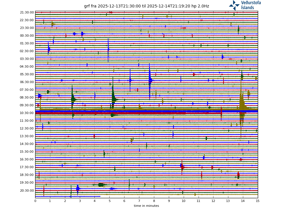
It seems a glitch. The seismogrqphs shows a big quake but that is the 3.1 a few hours earlier. There is nothing otherwise. The ‘M5’ ‘quake’ was perhaps a seismograph blown over in the wind?
https://www.emsc-csem.org/Earthquake/earthquake.php?id=1204135
Iceland Met Office still shows very low confidence. Maybe a penguin knocked into the station… 🙂
It has been removed from the listing. I do wonder what could have caused the glitch.
It’s very odd. In order to be autolocated, and published on our system, an event has to have associated autopicks on at least ten stations.
And if the autolocation is unreal, a ‘ghost’ from a much larger teleseismic event, it’s immediately manually removed.
Clive…Penguin? A very well travelled one if so. A sheep surely
Hoping that everybody had a wonderful Christmas I’d like to send my greetings and best wishes to you all and esp. Albert and Carl, with my sincere thanks for good education, info and also entertainment, from very unvolcanic London.
Wishing everybody here on the site all the best for the next year now (a bit early) having little time to get involved at the moment I promise to catch up later on these interesting pieces about Australia and the island I’ve never heard of.
Also special thanks to Hector for standing by my side once when appreciated Carl became impatient, and to Jesper for lots of knowledge about Nyaragongo.
Question about availability of part of the vedur.is website.
Since a week or three or so I cannot access the drumplot charts of IMO anymore. Also Vöktun pages and the Grimsvötn csm graph show “Not Found The requested URL /ja/drumplot/ was not found on this server.”
The only way to access to drumplots is via https://vafri.is/quake/
Has access been restricted to Icelandic users? I saw vafri is using the same url to link the drumplot graphs as I am.
Such as
Sorry part of my reply vanished
Has access been restricted to Icelandic users? I saw vafri is using the same url to link the drumplot graphs as I am.
Such as
😬😈🤔

The written drumplot https doesn’t show up. It is a ghost.
You are using https. The site is not secured: you should be using http
Thank you, chrome or adguard may have changed settings I believe.
Or I did without thinking …
https://www.usgs.gov/volcanoes/kilauea/past-month-monitoring-data-kilauea
Never seen this many green quakes in a long time, not a large total number but they are all relatively large in magnitude compared to the shallow quakes, particularly the quake southwest of Kilauea on the 21/12/22. I assume this is related to deeper level inflation that seems to have picked up heavily in the past month.
Mauna Loa has gone silent since it stopped erupting, whatever magma flow it has seems to be low at present, or is not high enough to rise continuously as has been expected and rather rises in larger blobs every few years with one showing up thsi September. So these deeper green quakes could be a reaction to Kilauea now no longer being pushed by Mauna Loa inflating, allowing it to inflate more and also to the north and especially west. It was suggested that mauna Loa inflating in 1974 was a primary reason the September 1974 eruption didnt go outside the caldera like the otherwise near identical eruptions in 1971 did, so Mauna Loa erupting recently now may have greatly increased the chance of Kilauea erupting on its SWRZ rather than towards the east like before. The SWRZ connector is quite distinct in the map, unlike the ERZ connector…
Actually looking at this now a few times, it is very clear to see that nearly all the south flank quakes are along a particular fault and not just randomly scattered, the fault which at the surface creates the Pulama pali. This is a well known feature for a few of us here owing to the many videos of lava cascading down it in the days of Pu’u O’o. But it is interesting this is the active fault as it is a more gentle slope that seems older and more buried by lava than the sharper Holei pali that lies semi parallel to the southwest.
The 2018 quake moved all the way to the rift zone but this fault must have been the greatest source of the movement it seems. The same is likely also true in 1975. It likely means the dilation of the rift was mostly at depth, which may support the 2018 eruption being in part a deeper intrusion than normal, a direct deep rift eruption at least after fissure 8 took off.
https://www.youtube.com/watch?v=tEPHaYXAc8E
Walking on an active hornito, seems not a good idea but it shows well how they got their name 🙂
Can also see how there is some Pele’s Hair on the lava, even though it is a bit more sticky and rough than pahoehoe in Hawaii is.
Active tube system as well I think. Etnean lavas have a rough look, probaly because of high crystal content
Etna lavas looks alot like Pacaya and Volcán Llaima, fluid but with some roughness to it. Probaly because of their sligthly evolved caracthers.
Villaricca and Masaya on other hand are almost Hawaiian in fludity because they are fresher from depth
I dont know if the lava on Etna is evolved, it can be full of crystals and primitive. The lava erupted in 2021 during that years over 60 paroxysms was describes as being the most primitive lava seen erupting from the summit in a long time, likely something to do with the enormous scale of the fountains and their very rapid succession, each fountain was about 5 million m3 of magma, and they occurred on average 3 days apart. The 2021 fountains also got over 1 km on many occasions, and over 1.5 km at least twice. The 2021 eruptions covered a huge area in lava flows too, the volume of lava in total was probably at least 0.1 km3 and at a high could be double that, although there arent numbers officially.
At the time I thought this would cause a flank eruption like in happened in 2000 when a similar set of eruptions happened but the volume of magma erupted in 2021 probably exceeds the volume of that eruption and maybe even the combined volume of the 2001 and 2002 eruptions and was still only a summit eruption, goes to show how active Etna is getting today compared to even recent history. I guess the summit conduit must be very open, it will probably eventually turn into a lava lake when it gets too wide but there is probably a lot more fountaining to do yet 🙂
I think it might be about time for an Etna article.
In Tas Diagram They are sligthly evolved trachybasalts, hawaiites, mugeraites, edge of normal alkaline basalt. So yes relativly fresh, the diffrence is neighible. But You are right, the rough look haves to do with crystal content, rather than being evolved
My favorite Christmas movie before Mary Poppins:
Little Lord Fauntleroy
And this has a reason: Sir Alec Guiness.
What a great actor and quintessentially British like a good cuppa.
Great piece and pictures.
I’m fascinated by stories of First People. As they did not modernize all the time, but are in a true sense conservative, they have always kept everything from their oldest ancestors. This is an enrichment in an ever-changing world which maybe changes too fast.
Thank you for the interesting piece about volcanoes that are not that popular being extinct or dormant.
And I wouldn’t have thought that penguins come up there.
Thank you Albert for this article, looks like Melbourne was not the boring flat boring -agicultural lands that first tought it was.
Newer Volcanics Province is a huge field, althrough eruptions are indeed infrequent so the magma soure is very weak, yet very spread out. Looks like magma resovairs woud be lots of small pockets in the ground there perhaps resting at crust – mantle boundary.
Any chance that an eruption will pop up in Melbourne?
Woud be fun with a Rangitoto like event in Port Philip Bay: basicaly a many years long nishinoshima like event, But that also requires larger magma chambers something that NVP may not have at current, as Auckland volcanic field seems a little more focused.
I doubt NVP will erupt anytime soon.
There have been no Newer Volcanics eruptions in Melbourne itself. They have happened more than 30 km further north and it is in theory possible that a lava flow would reach the city. A very unlikely event though. Melbourne as a city is very nice. Not boring but lively, and less intense than Sydney. Sydney is a lot more scenic though
Good climate too, similar to UK its just a little warmer. Melbourne is Almost Subtropical Oceanic ( broders on North NZ like climate )
Well before I learnt of the NVP I have flown over there many times in Google Earth and well ”boring and flat farmlands”
Now it makes sense that this flatness turns out to be lava flows that have buried earlier topography. Some of these flows many 10 s of km long
I have been there, it is all farmlands but at ground level it is not as flat as you think 🙂
Eruptions from 4 to 1 million years ago at Newer Volcanics were tholeiite basalt, and this is a common (although not universal) trait of these volcanic fields both in Australia and also larger ones elsewhere. So while a central volcano never formed here there does seem to have been some substantial generation of magma that has faded somewhat although is not dead. Atherton province up in Queensland also did this, and at the same time too, it us likewise still active although not a lot if data exists on its last eruptions, supposedly they are Holocene. Undara and the Nulla volcanic field have not produced tholeiites, but at least on one source it says the majority of the volcanism from Undara is from the past million years or so, which might mean this area will get much more active. Eruptions here are gigantic too, they are over 1 km3 standard, and Undara itself was as much as 30 km3. The last eruption 7000 years ago began slowly with tube fed pahoehoe but later became paroxysmal, and went full lava geyser flood mode right at the end for a short time and this a’a flow is still jet black in the landscape underneath its patchy tree cover. It was like Fagradalsfjall but about 50x the volume.
It looks like Newer has a remarkable variety of lavas. There are tholeiite basalts, alkali basalts, trachybasalts, basanites, tephrites, and even foidites. This is really unusual. Many volcanic fields erupt both foidites and basanites, or basanites and basalts. But I can’t think right now of any volcano other than Newer that has erupted foidites and tholeiite basalts together. That is also probably why Newer has such a variety of monogenetic volcanoes, the maars are probably predominantly foiditic, the cinder cones are probably basanites and tephrites, and the shields are probably basalts. TAS of Newer:
Instead, Nulla and McBride are mostly trachybasalt. Variety is less. Eruption style seems to be mostly large shield volcanoes. It is somewhat unusual, intraplate monogenetic shield volcanoes are usually alkali basalt, or tholeiite basalt. I’m not sure there are other such volcanic fields with trachybasalt shields. Shields can come in many compositions though, Mayotte was a tephrite-phonotephrite shield. Chinese volcanic fields tend to also have odd-composition shield volcanoes, for example Wudalianchi has tephriphonolite shields, Tengchong has trachyandesite shields, and Hainan basaltic andesite shields.
Nulla:
McBride:
Looks like maybe the McBride magma source is deeper then, I was under the impression it was variable and evolving with time from one composition to another. I know the Toomba volcano that is part of the Nulla/Sturgeon/Chudleigh field, has got composition that ranges from hawaiite (which I think is the same as trachybasalt) to basantite, in one eruptive sequence. I think the volcano had several sequences of massive flows too, early eruptions were stable and slow, but later on the eruptions seem to have gotten more unstable and with higher effusion rate, leading to shorter flows that were more dominated by channels. The last flow was basically just a fluid a’a flow, the eruption making it was probably a high eruption rate fountaining eruption. Kinrara was the same, although the later stage unstable eruptions were a much more important part.
It is a bit of a dream of mine that someone goes and does a deep detailed study, and installs a few seismometers in the area so we can get a look at the underground workings of these volcanoes. This place I think is different from Newer Volcanics, McBride looks like it is a centralized shield, and Nulla looks like a possible massive dike swarm that is evolving out of an uplifted area with a large store of magma below. But there is effectively 0 information on any of these possibilities so they are unfortunately just my own theories. I tried for 2 years to write an article about this but it just isnt possible 🙁
That is true: the deep valleys are gone but the land still undulates. I quite liked it. Of course, being there in winter did mean it was all green rather than brown.
Adding to your discussion above (mainly Albert, Chad and Hectór) about the origin of volcanism in Australia I’d like to add two interesting articles:
“As slabs of seafloor are subducted at the Tonga-Kermadec Trench, which runs from New Zealand all the way to Samoa, the vibrations reach all way to the mantle reservoir beneath eastern Australia and Zealandia. As a result, water and carbon dioxide shake loose from the reservoir and rise up to produce volcanic eruptions at the surface.
We found our first piece of evidence for this driving process in the deep history of volcanic eruptions in the region. There were two gradual increases in volcanism, one between 60 million years ago and 21 million years ago, and the other from 10 million years ago to 2 million years ago. These periods were separated by a brief (in geological terms) lull in eruption frequency.”
https://theconversation.com/eastern-australia-has-hundreds-of-enigmatic-volcanoes-new-research-shows-how-they-formed-151578
https://onlinelibrary.wiley.com/doi/full/10.1111/1755-6724.13148
This may be part of the story. There have been other papers claiming that the volcanism 50 million years ago is related to the plate graveyard underneath eastern Australia. A relation to the past 5 million years is much harder to prove, though.
This would be analogy to what happens further north regarding Mt Baekdu in North Korea. Hydrated long-since subducted pacific slab causing partial melt. Aided by leaky plate/thin lithosphere.
I thought I read somwhere that Mt. Baekdu was caused by flat slab subduction ? Has this theory gone out of fashion, or there is still debate ?
A general reminder if you post a comment which doesn’t appear: your message was probably held back for approval by our spam demon. It is something that happens to all first comments and to any comment the demon finds suspicious. It is sadly necessary. Approval by an admin may take a while: half a day is not uncommon. After approval, further comments should appear instantly unless the content has an issue. The demon objects to comments with only a link and nothing else, too many links, and various other things only known to the demon.
If you are very unlucky your comment is classified as spam. In that case I am afraid it is lost.
Found this just now, a youtube documentary on Kilauea and its eruptions from 2005 to 2018. Lots of footage that I have not seen before 🙂
And to see in the new year yet another unusually large and deep quake in the vicinity of Kilaueas summit.
Looks a lot like what happened leading up to 1959…
Thank you for posting this, I have never seen it before. Cracking documentary.
Afterwards I also noticed that there is a 1983-2005 vid too, as well as some stuff on the eruptions in the past 3 years 🙂
Watched that one too, both were engrossing.
10 microradians of upward tilt in the 3 weeks since Kilauea stopped erupting. I cant recall it being this high except for in 2018, and when the last two eruptions were about to start. And then all the big deep earthquakes around Kilauea in the past month, Pele is taking only a quick nap it seems.
The GPS cross caldera measurement shows 5 cm in about the same time. The ERZ connector is pretty quiet and Pu’u O’o shows weak contraction, but the SWRZ connector is lit up like a christmas tree and so is the southwest side of Halemaumau, in the general area of the main vent of the recent eruption. I think the ERZ might stay silent for a while, the next eruption will most likely be in Halemaumau in the same spot as before but the next flank eruption will be on the SWRZ.
You are including about 4 microrads from the ring earthquake. Subtract that and the tilt looks still moving but no more than it has done in the past. The GPS’s show inflation centred on the northeast of Halemaumau. The north side of the caldera has recovered around half of the deflation from the 2018 eruption. The south side has recovered only around 25%.
I think that ring fault quake still counts, it is caused by magma movement if the volcano and by inflation of the magma chamber as a root cause. If the quake line went back to the same spot that is different, but here the ground was permanently shifted.
And the south side if the caldera also is heavily influenced by the south flank movement after 2018. The fact eruptions have resumed means the pressure in the magma chamber has returned to before 2018 levels, just that the chamber has lost volume and elevation compared to before, which is to be expected when 1.5 km3 of magma leaves the summit and the top falls in. The CRIM UWEV plot is the standard plot used for basically all the major measurements since GPS came online, HVO themselves use more stations in addition but this one is the most important.
1.5 km3 is about 10 years of magma supply on average from before 2018, it has been nearly 5 years since that eruption, and the plot is half way recovered. Seems about right on track. The deep quakes might hint at deep magma rising up too, which usually sees temporary exaggerated supply, so something to keep watch for.
The jump after the ring quake means that stress is redistributed over a larger region. The situation has changed, and you can’t just compare before and after. Exactly how things changed is not clear, but it is better (safer) to subtract the jump in your calculations when judging eruptivity. The difference in north and south may be related to the movement of the south flank, but it may also be that there was some magma movement from the south into the caldera region, related to the eruptions. That eruption resumed shows magma influx but not by itself major recovery, since the crater became much deeper in 2018. The magna chamber was under less pressure because of that, and the subsequent eruptions did not require as a high a pressure. Let’s see what happens in the next few months. It seems not unlikely that there will be a resumption of the eruption. Somewhere..
There was a jump up on the tiltmeter before the last two eruptions too, associated with a shallow earthquake at the summit. It turned out to be a key precursor. These quakes release tension where it builds up, if the ring fault was being pushed without slipping then pressure was building, now that snaps back, returning to the mean, and removing the tension.
It is the same as how back in September Kilauea stopped inflating for a bit, then had the intrusion, and then jumped back up to the long term trajectory. This quake was not an intrusion or at least not one of any significant size, but I expect it was caused by magma movement directly. The GPS does show a possible small jump corresponding to this quake, which showed the caldera extended slightly, as well as the rim rising.
Based on the high seismicity, the next eruption from Kilauea is probably going to be within the month. The eruption probably stopped in September, when the lake stopped rising, but the conduit was still open to the Hamemaumau chamber allowing circulation between it and the lake fir a while. What was cut in September was the connection between the Halemaumau chamber and the south caldera magma source, which is now inflating rapidly. The last gap in eruption was 4 months between May and September 2021, and seismicity was elevated a bit between June and December 2020. So 4 months seems a rough standard for pressure to overcome the blockage. By this, an eruption seems likely to resume in a few weeks time. Just my prediction of course.
A very happy 2023 to everyone! May all your eruptions be as exciting and touristy as in 2022.
Happy New Year to you and everyone else!
I guess HTHH isn’t easy to top.
HTHH is a 1 of a kind, for a little while anyway.
Yeah, HTHH will likely stand alone even just on the volume end of the spectrum for a while.
Statistically at least I’m sure we’ll see another VEI 4 at some point soon. Speaking strictly of explosive events, and of course there’s no guarantees. But going off the last century, they’re common enough.
Last was Fukutoku and Soufriere, yes?
Wonder what will rumble back to life next, part of what makes this exciting.
Happy new year to everyone, hopefully a few volcanos give us a good show in 2023!
Company is claiming that there is a “dangerous situation” of the likelihood of a 7.0 in the area from San Francisco-to the nw of LA.
They are saying this company is Quake Predictions, and they are basing this prediction based on the two recent quakes in the area of Eureka.
From Zero Hedge
“Quake Prediction Says “Signal Just Hit,” Warns Of Potential Big Earthquake From San Francisco To LA
Tyler Durden’s Photo
BY TYLER DURDEN
MONDAY, JAN 02, 2023 – 11:05 AM
An earthquake rattled parts of Northern California on Sunday for the second time in two weeks. The 5.4-magnitude quake was centered about 30 miles south of Eureka. On Dec. 20, a 6.4-magnitude earthquake also struck near Eureka.
Now one quake prediction research firm warned that the next big one could be imminent.
On Monday morning, Quake Predictions published a warning that read for the next two days — there is a “dangerous situation” of the likelihood of a 7.0-magnitude “in the San Francisco Bay to NW of Los Angeles area.”
https://www.zerohedge.com/markets/quake-prediction-says-signal-just-hit-warns-potential-big-earthquake-san-francisco-la
Mac
Looking at these quote-on-quote “prediction maps”, they look more like weather maps. You can forecast earthquakes (I.e. a 10% chance of a 7.0 at Kīlauea in the next 10 years type of stuff) but not predict them (a magnitude 8.0 is going to happen on Kīlauea on Wednesday). If they are really earthquake forecast maps, they would have research and the chances coded along the faultlines (which most are visible on the surface). This is misinformation at its finest and do not believe them unless if real sources say otherwise.
I looked at my profile thingie beside my name suits it all… it looks like as if it was concerned and silently saying “yikes”…
It’s ZeroHedge — you expected better?
Well, never really heard of them until I clicked on the link. Looks like they have a reputation of following misleading sources…
https://earthquake.usgs.gov/research/eqproc/trackingstress.php
This is what an earthquake forecast map should look like (even though it is only where the most/least stress is, but it gives you a bit of an idea, but other forms do exist, just simply not a blob by these impostors).
Zach and all,
Thanks for the feedback. Looking at the site you provided, the image shows a large amount of stress in the middle of the area the company in the article issued an alert for. Just an FYI, I was skeptic of the claims, just looking for possible explanations.
From the link Zach linked above.
Macusn
Very much welcome 👍.
It is good to see realism win out. Sometimes you do have foreshocks, with a larger one following shortly after. That can also be on a neighbouring segment of the fault. So this can give a slightly higher chance of a stronger quake in the days after an event, but it is only slightly. And of course there are aftershocks, which typically reach up to 1 magnitude weaker than the main one: these have a very high chance of happening but are always much less than the main shock and taper off over days and weeks. In the case of an extreme quake, aftershocks can continue for years. This claim made several mistakes to be able to predict catastrophe. The slightly higher chance was applied to the San Andreas, rather than the subduction fault it was actually on. The claim was made that the entire S.A fault was at risk, rather than the region where the shock had been. An unrelated stress map was used. And finally, they failed to identify their second quake as an aftershock of the first one. There is no point pointing out their mistakes: they are in it for the claim, not for the science.
There is always a risk of a large shock on the San Andreas. Neither of the two shocks mentioned (one of which was an aftershock) was on the San Andreas. The warning area is far south of those quakes, on different segments. We can take this prediction with some caution.
There is no doubt there is a chance of a big earthquake on San Andreas, but we should take with a tiny grain of salt as they have a really big claim and, on that note, like I said, earthquakes are mostly unpredictable, which is why we always prepare for the worst on the daily. Better prepared than caught off guard (*most of the time, as these claims will cause some really unnecessarily crazy things to happen).
What is their “signal” that “just hit?” Some type of algorithm?
That’s a seriously bold and potentially dangerous claim. Surely if they were onto something they could work with the USGS to put out a better message?
I can’t see how quake prediction is anything more than “X% chance of Y+ magnitude quake over Z years.”
I went through the comments section of a few of his videos. That question is asked all the time by various commenters and as far as I can see he never answers those questions. I did watch one of his videos, just to see what it’s all about and if he does have some explanations to back up the claims. At one point he mentioned that “the electromagnetic energy is high”, so I guess the predictions are supposedly based on seismo-electromagnetics. (https://en.wikipedia.org/wiki/Seismo-electromagnetics).
Now, even if seismo-electromagnetics does work and there is indeed a sensor network deployed that can detect such signals, I would assume that you would be able to pinpoint hotspots of areas with a currently increased risk of an earthquake, where changes happen on maybe a monthly basis. He goes way beyond that and gives predictions that move from day to day. Tomorrow there’s a high risk in this area, but the day after the risk will move to this other area, like clouds on the weather map. It is my firm belief that this is totally bonkers and he’s only trying to generate as much traffic to his website as possible.
Speaking of the website. I wanted to find out more about who’s behind this stuff, but it turns out that the domain is registered to an anonymization service. Isn’t that just typical?
A number of his videos claim that some big quake has hit just as he predicted. Yeah, but he adds new predictions every 14 days, with maps all over the world, targeting all areas known for producing big quakes. On average there is around one M6+ quake per month somewhere in the world. Of course he will get one close enough every now and then.
Zerohedge is a conspiracy-ridden website with a leaning towards catastrophe. It also has some questionable links to Russian propaganda. It’s not a reliable news source.
I think the author’s name Tyler Durden speaks for itself 😉
@moderators:
Can it please be made a thing that Akismet automatically deep-sixes ANY post referencing ‘zerohedge’?
Please?
Seconded. Sadly Akismet has a mind of its own
Tyler Durden is the name of Brad Pitt’s antagonist/trickster character in Fight Club.
Is something going on at the Ollagüe volcano in Chille? I’ve seen some reports stating that there where earthquakes related to rock fracturing and it looks like Volcano Discovery has also changed it’s status colour.
5 VT earthquakes, 1 magnitude 3. Volcano discovery is tripping balls because this volcano isn’t doing anything to warrant alert at the moment.
Sorry Tallis I’m not sure on what tripping balls means. I assume ‘not warranted’? from context?
From a layman’s point of view, it could also mean ‘trying to get attention because something is happening’ or ‘they are deluded’
Apologies but not familiar with the term
In my view, volcano discovery has lost it. The news value of that site is at best on par with the tabloids. View it as entertainment if you like, but use other more official sources as a source of information.
Yeah, I’ll never forget the day they made me think Öræfajökull was erupting, pretty much the week before my wife and I were set to fly to Iceland for our two week ten year anniversary vacation… That was a fun one.
For anyone that missed that, VD posted apparently a VAAC training simulation of Öræfajökull having a plinian eruption to their list of actual volcano updates.
Not uncommon (for them?). We find it best to rely on the VC community to spot the real eruptions!
Tripping balls is a way to say whoever wrote that report was on drugs… Usually it is used to refer to the use of hallucinogens like magic mushrooms or LSD.
I think you get the idea from this point on 🙂
Ah, thanks Chad
https://www.timeline.cl/monitorean-actividad-volcanica-tras-sismo-en-volcan-ollague/
Based on this, really nothing too noteworthy. VD showing orange 3/5 alert while this article mentions “remaining green” is somewhat asinine.
I really like VD as an aggregate of volcanic and earthquake activity that’s easy to quickly view and catch interesting events. They handled HTHH pretty well with some good and accurate updates.
But as others mentioned, they’re also like a damn tabloid sometimes. As long as one looks for actual confirming sources to suspect info, VD can still be a fun tool (especially given they have an app, makes them very quick and efficient to view).
Just now, magnitude 4 quake just north of Kilauea at 19 km depth. USGS put out a statement about it. They it is related to interaction of the two volcanoes but the depth seems too high for that to me.
“HAWAIIAN VOLCANO OBSERVATORY INFORMATION STATEMENT
On Tuesday, January 3, at 3:31 a.m. HST, a magnitude-4.0 earthquake occurred 4 mi (6 km) northwest of Volcano, Island of Hawaiʻi, at a depth of 12 mi (19 km) below sea level.
This earthquake occurred in a region of stress interaction between Mauna Loa and Kīlauea volcanoes. The earthquake had no apparent impact on either volcano.
The Hawaiian Volcano Observatory continues to monitor Hawaiian volcanoes for any changes.
EARTHQUAKE DESCRIPTION
Magnitude: 4.0
Date and time: Tuesday, January 3, 2023, 3:31 a.m. HST
Location: 4 mi (6 km) NW of Volcano, Island of Hawaiʻi
Depth: 12 mi (19 km) below sea level
Aftershocks are possible in the coming days to weeks
EARTHQUAKE INTENSITY AND AFFECTED AREA
Potential Damage: No damage to buildings or infrastructure expected based on earthquake intensity
Maximum Modified Mercalli Scale Intensity: IV—light shaking (https://www.usgs.gov/natural-hazards/earthquake-hazards/science/modified-mercalli-intensity-scale)
Felt Reports: More than 160 within first hour (http://earthquake.usgs.gov/dyfi/)
Felt Area: Across the Island of Hawaiʻi
Visit NOAA’s Tsunami Warning Center website for updated information: https://www.tsunami.gov/”
Just my guess, but this seems more likely to be magma, it is the same place as the quakes leading up to eruptions at Kilauea in the 1950s and way deeper than where the interaction quakes happen, even a long way below the decollement fault and base of the volcanoes. Kilauea had a major deflation and near collapse in 1924 that was probably comparable to 2018 (no shallow magma chamber so no caldera, but similar total volume of magma). Then it went to sleep for 2 decades, before waking up with quakes in this area and eruptions of really hot lava at the summit in the 1950s and then ERZ in 1960, and then we all know the rest 🙂
Lava supply was relatively low back then, but now the supply is 10x as high as reported in the early 20th century. Maybe not coincidence it erupted after only a little over 2 years after 2018 then, instead of 20 years. So this could well be a similar response to such a drain but now much faster with the more open magma system.
Might get some fireworks with the next eruption 🙂
https://volcanoes.usgs.gov/hans2/view/notice/DOI-USGS-HVO-2023-01-03T06:25:18-08:00?utm_source=dlvr.it&utm_medium=facebook&utm_campaign=dlvrit-usgs%20volcanoes&fbclid=IwAR0nKnW9vRbWksZMJvj-luSur5vAVLMcQthCempMbFBwYC0eFVbAVOVwwdk
I wish I had the earthquakes map before the 1959 eruption at Kīlauea Iki to compare it to this, but yet it is hard to find. All there is only details about the earthquakes.
https://pubs.er.usgs.gov/publication/pp1806
I found the data in this. It is on page 72, or page 88 of the whole pdf. Actually the quakes before 1959 were deeper, 40 to 60 km. But then supply back then was lower and seems to have reached its modern value beginning with the 1959 eruption and then 1960 activating the ERZ properly. The recent quake was fairly large and not as deep as these, so is maybe not a VT quake itself, but at this depth it is also below any of the known decollements, and really still very close to Kilauea and its magma system. This quake as well as the deeper blue one next to it on the map could mean the magma system is pressurized to a considerable depth.
Seems that 2018 was really a caldera collapse of just Halemaumau, and not Kilauea as a whole, which deflated as expected but was largely unscathed by that eruption despite the size. Makes sense really when only 20% of Halemaumau drained out, the rest really shouldnt have changed that much. What has been more seriously affected seens to be the connection between Halemaumau and the greater south caldera chamber, the central hub of Kilauea. The ERZ connection also seems disrupted somehow in the last year, the summit is inflating now strongly but the ERZ is dead silent, the SWRZ is not silent though…
Earthquakes by month at Kilauea since the start of 2018. The eruption in 2018 is still in the timeframe and will be for another 8 months so really throws the scale out but it is pretty clear that the quake rate for December is a lot higher than before at any point last year, the last month with comparable or greater quakes was in January 2022 when a swarm of small but numerous quakes happened at 15 km depth under the summit, and then back in September 2021, before the recent eruption began.
Quakes before the last eruption began to get higher in July 2021, and culminated in the SWRZ intrusion of August, and then the eruption a month later. So can be very roughly estimated that it takes at most 2 months to reach the point of overpressure in the current setup when there is no outlet, and perhaps less. Well we are at a month now, so some time in early February.
January 15 to February 15, the eruption will be in this timeframe 🙂
Chad, how’s the weather out there on that limb?
Thanks for the educational and entertaining post.
Eruption on Io
https://phys.org/news/2023-01-large-volcanic-outburst-jupiter-moon.html
My favorite Moon in action : D
Endless fascination.. Thank you
Violent outbursts are ascossiated with violent lava fountains with the sulfur gas violently degassing from the basaltic magma in the upper conduit. We are talking about near plinian style, very violent and dangerous. It may leave a dark sillicate pyroclast ring on the surface and a red sulfur spot as well.
Its also possible that this is a Laki like event like Pillan Patera in 1997 and 2010 s with large fissures erupting silicate lava on the surface. Ionian lava flows during these outbursts are tought to be emplaced at many
10 000 s cubic meters a second. IO s surface is quickly repaved by New sillicate lava flows and sulfur frost.
IO is not good for a human base even If the radiation was not a problem..
Everything either gets buried by sulfur snow or sillicate pyroclasts or a basaltic lava flow buries everything
Ionian volcanoes are formidable beasts, capable of hostig open lava lakes many 100 s of km wide with heat influx enough to keep a very thin skinn on it .. Impressive stuff
One Ionian lava eruption produced a 56 km3 basalt flow in a few weeks so incomparabely faster than Holuhraun or Leilani
Pretty much imagines a Giant lava fountain miles miles high
and indeed these lava fountains have been resolved from Galileo from orbit as a glowing bright in the sulfur plume. Woud be fun to get something Ionian scale from Iceland 🙂 But woud be bad news for the Icelanders
That kind of event in Iceland would be bad for you as well!
Not sure if the fountains would be so big. The Pillanian eruptions were fissures, and Io also has not much of an atmosphere so the gas will escape a lot more readily when the magma surfaces. Also the 1/6 gravity. Flood basalt eruptions on Earth (or Venus) probably dont have lava fountains bigger than eruptions we see now, not least because lava fountains over 1 km tall become subplinian and probably dont count. Lava on Io probably cools slowly being in a vacuum so fragmented lava thrown km high probably still lands as a liquid but would be an explosive eruption here.
I wonder what an ignimbrite eruption would look without an atmosphere. Pretty much everything visual about a pyroclastic flow is because they happen in our atmosphere. In a vacuum dust wouldnt form or be blown around, an ignimbrite might just look like a really thick frothy lava flow moving at great speed.
See kilometers high lava fountains, lower gravity and slow cooling by radiation. Ionian eruptions will look like huge versions of Calbuco lava fountains .. just hotter and brigther. With luck perhaps Halema’uma’u coud provide us with something Ionian one day 😉
Ionian eruptions must be an insane sight
Today is our closest approach to the Sun! Enjoy
What a lovely gift for my birthday! Thank you for arranging it, Albert. Shame I can’t see it due to cloud.
With the exception of Hawaii’s activity (and Io’s eruption), it’s been or at least appears to be rather quiet right now.
Anything interesting going on under the radar at the moment worth discussing?
Etna is still erupting
https://m.youtube.com/watch?v=wedBboQiNy4
Video of Etnas current lava tubes, mobile but much much less fluid than Hawaii and Iceland
I’m personally interested in Villarica’s growing unrest since October. Many things could happen, from flank eruptions to a subplinian paroxysm, or just going back to normal. But of course we are looking at a months-long build up, it is not something that is developing rapidly:
https://rnvv.sernageomin.cl/volcan-villarrica/
Stuff about the Chilean volcanoes doesnt usually show up in English in an obvious way, no idea Villarrica was doing anything noteworthy still, there was a brief mention last year.
Major eruptions are pretty unique in that it is still mostly effusive, Villarrica might have the title of biggest lava fountains of any volcano. Sure Etna is the real winner but its fountains are always ashy and probably most of the fallout is solid when it lands. Villarrica is like a spatter cone the size of a stratovolcano… I still remember seeing the 2015 eruption on the news that morning, and that was only a small paroxysm lasting an hour, some lasted days…
Nothing large right now, but I noticed Taupo is still rumbling, but the recent quakes (today, 1/5/2023) are outside of the lake area proper (and former caldera) and are rumbling away beneath the town of Taupo, north of the Hatepe caldera.
Yes, these are actually slightly to the north of Taupō, related to the Wairakei and Rotokawa geothermal fields and power stations in this area, and apparently unrelated to the ongoing caldera unrest.
https://m.youtube.com/watch?v=NuUBYxbTycs
Etnas eruption continues
Viscous and stiff but still mobile
Alert level for Kilauea raised to Orange:
Volcanic Activity Summary:
Kīlauea volcano is not erupting. Increased earthquake activity and changes in the patterns of ground deformation at Kīlauea’s summit began occurring in the early morning of January 5, 2022, indicating movement of magma in the subsurface. At this time, it is not possible to say with certainty if this activity will lead to an eruption; the activity may remain below ground. However, an eruption in Kīlauea’s summit region, within Hawai‘i Volcanoes National Park and away from infrastructure, is one potential outcome.
The USGS Hawaiian Volcano Observatory is raising the volcano alert level/aviation color code for Kīlauea from Advisory/Yellow to Watch/Orange due to this activity.
HVO will continue to monitor this activity closely and adjust the alert level accordingly.
HVO is in constant communication with Hawai‘i Volcanoes National Park as this situation evolves. The activity is confined entirely within the park.
New dike intrusion has caused the summit tiltmeter to jump 8 microradians or so and is still continuing. Magma broke out 10 minutes ago or so under the lake I think, making a large dome fountain:
I must say I did not expect this just yet. There wasn’t the typical precursory earthquake activity along the East Rift Zone that has preceded most historical eruptions and intrusions, regardless of whether they happened in the East Rift, Southwest Rift or Summit. I did suspect that extensional strain was building up very rapidly across the summit area, in a way that is uncommon, which may have favoured a dike to form at the summit well before the East Rift Zone started to experience any rock breaking. The last two eruptions were also kind enough to throw a non-eruptive intrusion in advance, which didn’t happen this time.
Sheet pahoehoe lava:
🙂
Impressive eruption.
Looks alot like 1950 s and 1960 s Halema’uma’u shows But also with a +300 m lava lake below it
Yes, but this is a lot bigger 🙂
Lava lake before this was at about 152 million m3 combined since December 2020. It is at about 370 meters, the laser points to the old lake pit which is probably lower down than the rest of it, there isnt much info. I know if it goes up by another 30 meters then it will flood some of the downdropped block, and all of the other block to the southwest, so reaching that 30 meter mark might take a lot longer than it looks now.
But then, the last two eruptions got to about 20 million m3 in a couple days. The lake now is apparently 10 meters deep and 300 acres of new lava, which would be 1.2 km2 and 12 million m3 at that point which was about 3 hours into the eruption. Most likely it is a lot less than that, probably under 10 million m3 at that time, but that was also 4 hours ago so whatever number it was then could have doubled, if the lake has reached 20 million m3 now would not be a shock, although if it is less that is more likely.
10 million m3 in 3 hours is a rate of 3.3 million m3/hr, which is an effusion rate of 300 m3/s. Even if it is half of that this is as fast as the start of the other two eruptions. I wonder if maybe my prediction was right and some deep magma did rise up and accelerate things a bit.
The lava lake crust in front of the B1cam just opened up, lava is spouting from numerous openings. The first lava started spouting from the spatter cone in front of the cam, but I didn’t save a capture. 10 minutes later several fissures have opened around it. Because this new eruption site is more to the side of the lake I expect it will dominate the one in the centre which has a greater column of degassed lava on top:
Looks like blobs of gas rich buoyant magma keep spouting from the initial vent near the centre of the lake. The other fountaining areas remain very minor. The live view is also showing a drainback area, where lava is converging and disappearing into the lake with vigorous spattering.
Will the 2020 – 2023 crust break by the weight or will it just float ? Perhaps the crust will soak up the New lava like a sponge as it Did with some previous flows. Woud be fun and cool of the lava piling up on the top woud break the dams crust
Hard to know what will happen.
https://m.youtube.com/watch?v=xIPzdF_2cp4
Nice lava wave at start of the fountain shows how fluid this lava is
That video might be within 10 min of the whole thing starting. Here is the original. By Janice Wei. Hopefully she was there to fil the actual point lava began to erupt but this is good enough I think 🙂
https://www.facebook.com/100005497051693/videos/623332163126953/
Says it was taken at 4:30, HVO says the eruption began at 4:30, and the tremor begins at about 4:33 on the seismometer Albert links below. This is the 50+ meter fountain HVO said happened at the start.
What I think is being shown is the vent blowing itself out. The fountain at the start is being forced through that little glowing hole that has been visible for months now. The wave is when the pressure is too much and the hole is blown open, releasing a huge volume of lava very fast which gushes over the flow and breaks at the flow front which is visible. The fountain dies off immediately and becomes the bubbling dome fountain that most other videos show and not the powerful jet it was at the start. It is also visible that the lava wave washes over and floods one of the small hills, one of the frozen islands from back in 2020, those are at least 10 meters tall so this wave was massive.
If the eruption began within 10 min of this, then it shows how fast these sheet flows move. I think that first picture linked by Hector above is probably only a little bit later than this video. So lava flows moved at least a few hundred meters in a couple minutes, or at least as fast as walking speed possibly much more. Was probably exactly the same for the beginning of Mauna Loas eruption, maybe even more so. It was very lucky that 2018 didnt start off this way…
To original of Janice Wei was already included in my link
Absolutely spectacular.
Impressive video on Janice Wei s Hawaii Volcanoes National Park FB pge
Are this lava fountains erupting through many 100 s of meters of liquid lava? Then an empty caldera woud produce some insane lava fountains from this. The ponded lava lake probaly masks the full force of these eruptions
The fountain is powerful because it is all of the force of the eruption being focussed through that tiny glowing hole. I dont think it is necessarily reflective of the actual size of what the fountain would be if the vent was in open air. This lava is probably old degassed lava from the lake, goes to show how it really doesnt cool down at all unless it is actually in contact with the edge, it is still extremely fluid and glows bright orange in daylight.
High fountains during hawaiian eruptions also dont usually happen at the start, they are more often later in the eruption when the force is focussed into one place, like happened at Mauna Loa as the eruption declined and became unstable. It isnt a rule, some high fountains are sustained for weeks like at Holuhraun. But high fountains at Kilauea are associated with conduit formation or sustained activity, Kilauea Iki, Mauna Ulu and Pu’u O’o. The biggest exception is in 1960 at Kapoho but that eruption was near the ocean and probably had extra water in the magma for that reason.
I think though, if the lake drains out then high fountaining could occur. Most fountains on lava lakes are drains not sources of upwelling. The lake is degassed but not completely, if a large intrusion or eruption happens away from the summit and all of the lava has to drain back down the conduit, all of the gas in the lava will try and escape back through the same conduit… It wont be a lava geyser type fountain but the results could be very impressive, maybe even more powerful than an eruption fountain. This might have happened in 1868, and it will happen again eventually 🙂
Fountains are driven by gas and this rises to the top. As the driving force is at the top, changing the depth of the lake will not change the dynamics of the fountains. You’d expect the lava (magma?) aquifer to be convecting, and the newer input will come to the top. But the gas gets there first
Live Kilauea eruption:
Some lava has started to erupt inside the pit that contained the lava pond during the previous eruption.
On Jan 6, 2023, at 06:09:52 UTC, HVO raised the alert level to red and acknowledged the continuation of the eruption at Kilauea.
EpicLava on facebook has some fantastic footage of the lake a couple hours ago. The whole bottom of Halemaumau is glowing orange. For sure it will shrink in area over the next few days and might just be a spatter cone in the middle next week but right now it is spectacular. His video really shows the sheer volume fro mthe middle fountain, not tall but it looks like a ruptured mains water pipe.
He also has a video of a really tall fountain from Mauna Loa. Official word is that the fountains near the end were over 150 meters, maybe 200 meters. I didnt know there was any video of it until now 🙂
https://fb.watch/hTxsi4UOCv/
And for Hector, this shows the exact point the spatter cone started to bubble and the rest of the crater on the east side really opened up 🙂
Nice. It looks like lava has erupted through existing openings in the lava lake crust. Here it can be seen to erupt though a spatter cone, probably the opening was narrow so lava eventually preferred other paths out. You mention that the location of the main fountain coincides with the small lava pond in the middle of the crater, that is also interesting. If the crust stays stable then those holes will still remain underground and condition eruptive activity in the future. The lava lake may end up having different compartments separated by layers of rock.
The major fountain is also the glowing vent that has been visible in the centero f the crater now for months, it was even a small lava pond last year for a short time, and was largely unaffected when the eruption itself stopped, stayed a glowing hole.
Now it is starting to show in the lake. I guess it is from the small ooze up in the middle of the old lake pit. Most likely this is lower down than the lava outside of the crater, the lake is probably going to jump up instantly when the lava flows in soon.
That came much quicker than I had expected. Good start of the year! On the tilt meter, you can see that there was a run-up of perhaps 10 hours where the magma was reaching the surface before the eruption. The tilt also suggests that the first break-out was (mildly) explosive, I guess from gas underneath the lava lake crust. The seismographs show that the magma was on the move about 1.5 hours before the eruption was established: it went quiet again after 30 minutes, until the eruption an hour later. That quiet phase is typical for when the conduit has filled up and the magma is waiting for something to fail.
The GPS has been going up since September, as pointed out here, more or less in tandem with the decrease (cessation?) of the previous eruption phase.
I think this will count as a resumption, not a new eruption.
The images are spectacular!
USGS has an arbitrary definition of a new eruption being 3 months after lava disappeared . So the eruption in September 2021 was a new eruption, but the eruption in Leilani in 2018 was part of the eruption that began at Pu’u O’o in 1983. There is one exception they made, which is for the 3.5 month pause in 1971-1972 at Mauna Ulu, but that exception is not always given, and most maps still show it as two eruptions.l
I believe this standard is also folliwed by the Smithsonian, abd probably by other volcano observatories, although they may have different exact definitions. Some may consider any new intrusion that erupts to be a separate eruption even if its parent volcano was erupting somewhere else already. I know even USGS has a bit of ambiguity about the eruptions in 2007 and 2011 in the middle ERZ of Kilauea, because the magma composition is a bit different from Pu’u O’o.
https://www.youtube.com/watch?v=b0W2HYhP0BA
Livestream right now 🙂
Looks like the original big fountain next to the island is nearly dead, it is drowned under the lake and just a zone of upwelling now. The new major vent seems to be the vent that was spattering really high, it might be that hornito that reactivated or is close to it. But this vent is as powerful as the original so the eruption hasnt declined that much just shifted.
I think this vent will become the new lava lake now as the original lake basin is weekly active and the old cone is dead, possibly there will be more than one lake even with both of the spattering vents turning into stable sources.
Lava filling on the 2020 – 2023 crust
Will it break by the weight ? Or will it float up like before, or will we get a lake with many interior melt sheets separated by earlier crust like Hector tought?
I think it will float the crust, it was only a couple months ago lava used to leak out of the edge on a near daily basis, and those cracks are all still there.
But it is maybe going to be a bit more messy than in 2021. The lake crust in the first eruption was light tephra from lava interacting with the lake water. But now the lake crust was much bigger than it was a year ago, so maybe only the lightest parts will rise, and might drift to the side and expose the liquid.
The other option is it just makes a new lake, it looks like the lava on the west side is not being fed, only the east side is active. So the lake might not behave as a simple object anymore.
But I still expect it to just go on as it did before, that is still the most likely option, just on the other side of the crater from before.
New post is up! We end the year as we finished the last one: with a Hawai’ian eruption. Long may it last!
https://www.volcanocafe.org/the-2023-kilauea-eruption/