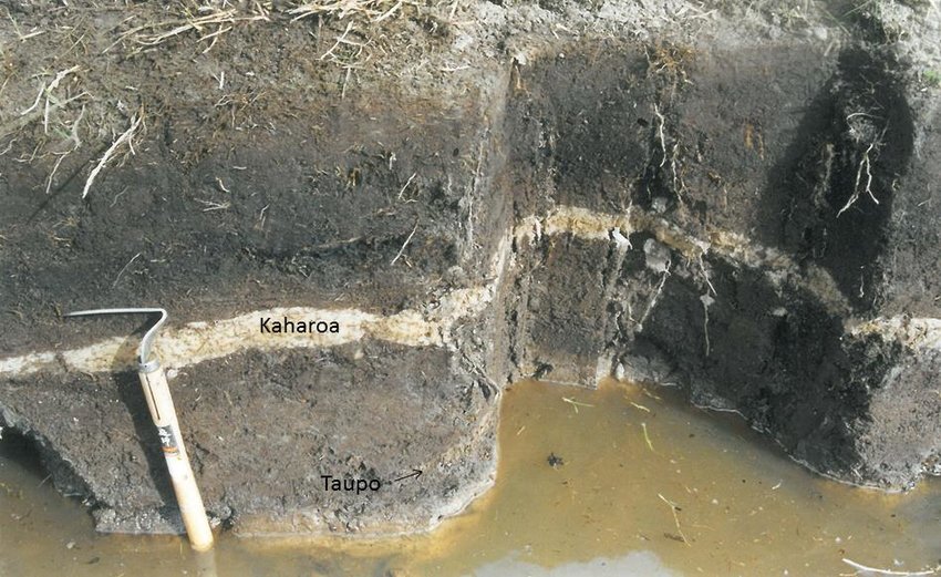
The thin white band in the centre of the photograph is ash deposited by the Kaharoa eruption exposed in peat at Waihī Beach, Bay of Plenty
This post is about the Tarawera Kaharoa eruption, and shows that it happened in June 1306. But it is a long story, connecting places as far apart as Taiwan, Ecuador and the Antarctic Peninsula. Enjoy!
Large volcanic eruptions throw out their ash and gas into the atmosphere and forget about the mess. They are heavy smokers who have never heard about such inventions as ash trays. (Mind you, most young people will not have come across those. We have at least cleaned up some aspects of our world!) One of our house rules is ‘You make a mess, you clean it’. It is applied within limits, of course. But volcanoes couldn’t care less.
The amount of ash that major eruptions deposit is outside of our experience. Etna left a layer of ash in local villages, requiring dump trucks to collect it and take it somewhere. Cumbra Vieja buried houses up to their chimneys. A decent eruption can cover many thousands of square kilometers in ash deep enough to kill the vegetation. Much later, people will find a distinct layer in the soil and wonder what had happened.
An important layer is found over much of the North Island of New Zealand. It is called the Kaharoa tephra. An example is shown below, taken from a peat bog at the Bay of Plenty. The layer here is about 5 cm thick, and is distinctly white compared to the black peat. Above the layer the peat is blacker than below. This is thought to come from burning, evidence not of volcanic activity but of human damage. Polynesians had reached New Zealand and had begun to make it their home. The evidence for their activities is only found above the white layer, not below. The data of their arrival is disputed, but this suggest they arrived around the time of this eruption. So, when was this ash deposited? And which volcano did it?
Let’s first take a step back in time. The colonization of New Zealand was just one part in an event that changed an ocean and created a world. It was the peopling of the Pacific.
Peopling the Pacific
The Pacific Ocean is an amazing place. The expanse of water is unimaginable, stretching halfway across the world. The continents that line it are worlds apart, with completely different people, history and culture. Australia’s and Papua New Guinea’s Aboriginees, the Han Chinese, the Chuki reindeer people, and the First People in America have nothing in common. The ocean that keeps them apart is occupied by different people again. They live on the volcanic islands that pepper the Pacific. Some of these islands are isolated to the extreme. Other islands form closely linked archipelagos. In either case, the people that live there are remarkably uniform in culture, in spite of living across an area larger than any continent. New Zealand’s Maori are part of that culture. The peopling of the Pacific is the ultimate story of adventure; and exploration of the unknown, knowing there could be no going back. When and how did it happen?

The shores of the Pacific ocean were first reached by humans more than 50,000 years ago. Impressively, that had already involved an ocean crossing of 70 kilometers into New Guinea. he abilities of people of that time went well beyond tools and cave paintings. The nearest Pacific islands of Melanesia, such as Bougainville, were also reached. But here they remained, on the rim of the Pacific. They only went to islands they could see. The horizon was their limit. The island hopping brought them to Australia, but the deep Pacific was beyond them.
The true expansion into the Pacific started in Taiwan, perhaps 5000 years ago. The people grew rice and millet, and kept pigs and dogs, and they took these with them. Evidence of their presence quickly appeared on the Philippines and Sulawesi. Rice did not grow well there, and it disappeared from their basket. Instead they adopted several tropical fruits. Chickens were added to the animals they kept.
Different groups now dispersed to different regions. One of these groups settled around the Bismarck Archipelago, off the northeastern coast of New Guinea. Here they developed a distinct style of pottery called Lapita. By 3000 years ago, this pottery appeared on Fiji, Tonga and Samoa, 5000 kilometers distant. And they traveled amazing distances. Guam was colonized by the Lapita culture, and that involved a continuous sea journey of 2000 kilometers. Was that an accident? Or did they know where they were going, and did they come prepared for long-distance migration? A trade network linked their islands: obsidian (a very valuable hard volcanic rock) from New Britain (part of the Bismarck archipelago, and a dangerously volcanic place) was found across much of the newly colonized world of Melanasia. The sudden expansion may have come from improvements in their canoes (perhaps the outriggers) but this is not known.
The Lapita culture suddenly disappeared from western Melanasia. It remained at Samoa and Tonga, but it lost the characteristic pottery. The trading network had collapsed. Some seafaring remained, and over time a new type of canoe was developed, which used a double hull rather than outriggers. And sometime between 1000 and 2000 years ago they began to expand eastward into the sparser islands of the southern central Pacific. The sudden resumption may have come from new technology (the double canoe) or just from the discovery of islands beyond the horizon. The amazing journeys now reached the Marquesas islands, Easter Island and even Hawai’i. They build their empire of volcanic islands by going against the direction of the prevailing wind. This may have been deliberate: by going against the wind, if anything went wrong they could quickly go back.
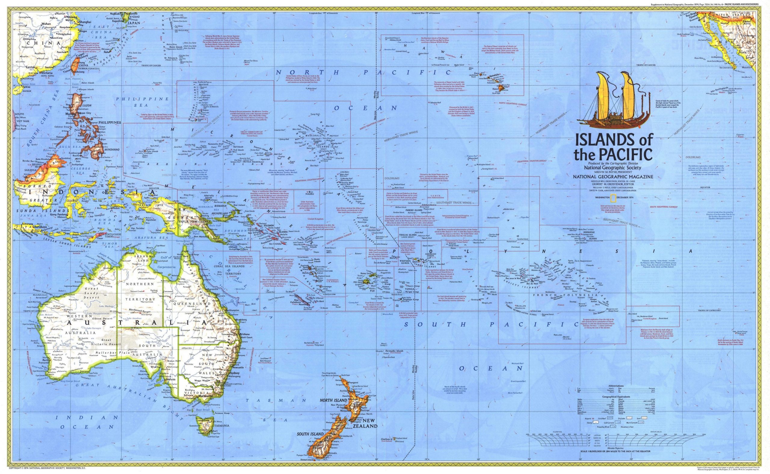
Map of the Pacific showing the islands and island groups of Polynesia. Click on the image for higher resolution
The sweet potato was added to the foods they grew. This was very unexpected, as this is a South American plant. The word they used for the sweet potato even has a South American origin. (It is however also possible that the sweet potato had spread naturally to the eastern Polynesian islands, before any human arrival.) Contact with South America is proven by genetic studies, which found American DNA in the genome of the eastern Polynesians, but not the other way around. That makes sense, given the size of the populations: genetic contact would have been highly diluted among the 100 times larger population of South America. There is uncertainty whether the Polynesians reached South America, or that the Americans came west and met them there. The contact appears to have been with people from the region of Colombia or Ecuador: both the human genetic tracers and that of the Pacific sweet potato point at this area. The human genetic signal is limited, and suggests that the mixing of populations happened only once. The fact that they acquired a new food suggests that the contact was not caused by a American canoe caught off guard by wind and currents and accidentally driven to Polynesia. It seems more likely that Polynesians traveled to South America, as they were the ones who had the ability and were already traveling that way. The arguments get heated and are driven more by opinions than by (sparse) facts. We do know that the early contact was with people from the Tuamotu islands and not (as often argued) with Easter Island. Traces of South American DNA is not found in Easter Island populations until 100 years later, well after Easter Island was colonized.
It has been argued that this Polynesian contact, around 1200, introduced their chickens to South America. Chickens came to South America with the Spanish. There is however some evidence for chicken bones in Chile which predate Columbus. This requires confirmation and the genetic evidence for non-European chickens is currently inconclusive. If confirmed, this would strongly point at an attempt by Polynesians to establish a settlement in South America. Such an attempt could also most easily explain both the genetic mixing and the acquisition of the sweet potato. If so, the settlement failed and like the Vikings in Newfoundland, the Polynesians left again. But if neither the chicken nor the sweet potato evidence holds, then we don’t know what happened! The only solid data we have is on the date, around 1200 AD,
But when did this expansion across the Pacific happen? Early carbon dating had indicated that the Polynesians spread during the first millennium AD, perhaps from around 500 AD. But more detailed studies done later found more recent dates, and this divided the scientists in an ‘early’ and a ‘late’ camp. Genetic studies added direction to the dates. The genetic diversity indicate that the expansion occurred in two distinct colonization waves. The first wave began in Samoa, and reached the Southern Cook Islands around 800AD. The second wave began around 1100 AD, and expanded from the Southern Cook Islands. Hawai’i was settled around 1200, apparently by two different groups.

From Ioannidis et al (2021). Click on image for full resolution
The genetic tracers that show mixing with a South American population are found in the area of the Tuomotu Islands, and in the islands settled from there, but not elsewhere. The date for the mixing agrees well with the Polynesian expansion, another indication that the contact was initiated by the Polynesians during their longest journeys. Interestingly, the islands with the American tracers are also the islands which have a tradition of stone monuments, such as the statues of Easter Island. It has been argued that this tradition also came from a South American influence.
The Polynesian expansion was not haphazard. They clearly knew where they were going. The Polynesians had recorded where the islands were, and had developed excellent navigation ability. They had explored and found the islands, returned to their homes to report and plan, and finally set out with a colonization cargo consisting of enough people to successfully settle, their crops and their animals. Even the Pacific rats which spread with the people may have been a deliberate cargo, providing another food source. They settled unoccupied locations. They left us no colonies in South America or Australia. They only went were none had gone before.
A long-distance trading network was again established, among the largest the world may have seen up to that point. Stone adzes, needed to make the canoes and which were made from basalt found in only a few islands, were traded around the entire region. This trade network was centred on the Southern Cook Islands. But over time it contracted and declined. The Marquesas dropped out of the network before 1400, and long distance trade may have ceased before 1500. In contrast, trade with nearby Samoa continued into the 1600’s. The reason for the decline in trade is not known. The 1453 eruption of Kuwae has been blamed but there is no evidence linking the two.
The incredible expansion happened during only a brief period lasting no more than 200 years. In this time the Polynesians colonized the Pacific, and discovered America before Columbus did. (They were not the first to do so, though. The people who lived there for 15,000 years or more (but are rarely credited with discovering America, and both the Inuit and the Vikings also got there before the Polynesians. Columbus came last in the discovery competition.)
For the Polynesians, finding a new Pacific island was the trip of a life time
The mammalization of New Zealand
The expansion across the Pacific took the Polynesians to the biggest prize of their empire, New Zealand. here they became the Maori. The Maori have stories about their history which tell that New Zealand had been discovered already by 800 AD, but the great fleet of canoes which brought the settlers only came after 1350. (The dates are based on counting generations.) The Polynesians knew where they were going. The original number of settlers may have been as large as 500 to a thousand. Genetic data suggests that the settlers came from more than one Polynesian island, either in a combined fleet or as separate arrivals over a century or more. The new settlers quickly spread out along the coast line.
Not everyone has agreed with these dates. Just like for the Polynesian expansion across the Pacific, there was a group advocating a ‘long’ history, where the settlement happened as early as 900 AD, and one arguing for a ‘short’ history with a settlement after 1200. The evidence for the long history came from carbon dating. However, these data have since been revised and the evidence now strongly suggests that the ‘short’ history is correct. However, a date of 1350 appears too late, for several reasons, including population growth models and the fact that Polynesia expansion had largely ended 200 years earlier. Currently, the first human arrivals to New Zealand are thought to have come between 1250 and 1325.
This migration took the Polynesians outside of their comfort zone. Polynesia is tropical, and New Zealand is not. Their tropical crops would not grow in New Zealand, with one exception: the recently acquired South American sweet potato. Without their gardens, they became hunter/gatherers. This was probably their common approach when settling in a new place, but the Pacific islands had limited resources for hunting which quickly ran out, necessitating a return to gardening for a living. New Zealand was much larger and could support hunters for many decades. But not forever. The new arrivals may have been excellent seafarers and navigators, they were not good conservationalists. It was too easy. The mammalian predators, both humans and rats, found New Zealand to be a walking buffet.
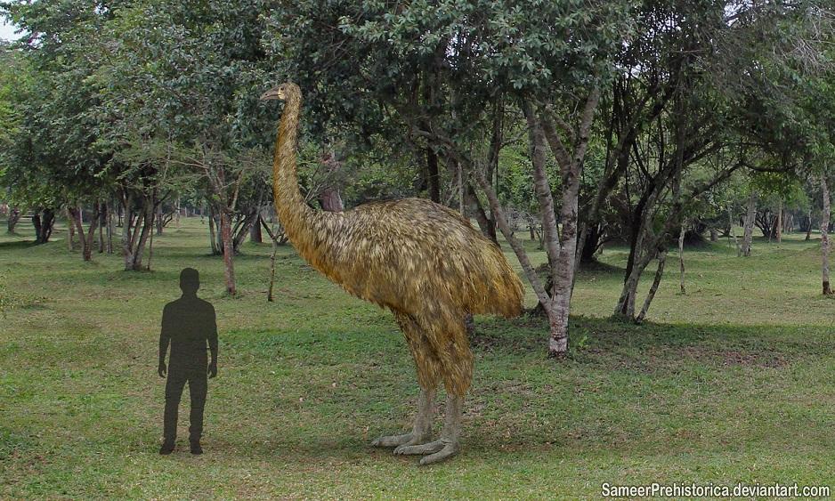
Top of the menu were the moas, flightless birds that had evolved to fill the ecological niche of grazers, and which had reached a size commensurate with that. They were as large as a small cow, and very edible. The Maori quickly established themselves as moa hunters. Their early settlements were on the coast, and shellfish and seal also became an important part of their diet. The coastal locations could be dangerous. A large tsunami in the second half of the 15th century wiped out part of the coast, and severely damaged many settlements. In places the tsunami had a run-up height of 30 meters.
New Zealand had been densely forested, and this made settlement of the interior difficult. The Maori began to burn down those forests. The hunting, the burning and the rats changed the land. All 11 species of Moas went extinct within 200 years of the arrival of humans. Even seals nearly went extinct. The hunter/gatherers now walked into a food crisis. In response, the population developed new, local crops, mainly suitable to the warmer climate of the North Island. They also moved in-land.
By the time the Europeans arrived, there were some 100,000 Maori living in New Zealand, but much of the land had become ecologically impoverished. It was a large scale change similar to what had happened on all Pacific islands, but it took much longer in New Zealand.
The Maori and the volcano
New Zealand has a unique way to date archaeology. This is a volcanic land where eruptions occur regularly. Small eruptions only have local effects, but large eruptions can leave traces across much the North Island. Over the time when the Maori lived in New Zealand, before the arrival of Europeans, there were six eruptions large enough to leave recognizable tephra layers in coastal regions where the Maori lived. The oldest of these is the Kaharoa Tephra, dated to around AD 1300. The second one is called the Loisels Pumice, a coastal pumice layer that arrived as a sea raft somewhere between AD 1305 and 1345. The third is the tephra from the Rangitoto Island eruption, which is only roughly dated to somewhere between AD 1410 and 1550. Finally, there are three tephra layers from Taranaki, namely the Newall Tephra, around 1600; the Burrell Tephra, around 1655, and the Tahurangi Tephra, around 1755. Of these six, the Kaharoa tephra and the Loisels pumice are most widespread, although the latter is only found at the coast.
The 230 AD Taupo tephra was the last major tephra layer before the Maori arrival. It covers 20,000 km2 on land with a thickness of more than 5 cm, to the east and north east of Taupo. A lot of the Taupo tephra ended up at sea: it can be found as a pumice layer on the beaches of both the North and the northern half of the South Island. Not surprisingly, there is no indication of any Maori activity below this layer. The Rangitoto island eruption did cover Maori settlements under its ash: New Zealand was clearly well settled by this time. The impact from the Rangitoto eruption did not spread far; even though the eruption was voluminous and lasted a long time, there was not much explosive activity apart from some water-magma interaction during its early phase. In consequence only the nearest islands were affected.
The Loisels pumice came from an underwater volcanic arc north of New Zealand. The precise origin of this eruption is not fully established: it is named after Healey volcano but it is not certain that this was the source. The pumice is rhyolitic, with a single chemical composition. Rhyolite is not so common from this area, and it makes an origin in a single volcano likely.
The Kaharoa tephra came from a large eruption at our old friend, Tarawera. The tephra covers 30,000 km2 on-land with a thickness of at least 3cm. The tephra is distributed along an arc extending both southeast and northwest from Tarawera. It extends along the coast of the Bay of Plenty to close to Auckland. Unlike Taupo, the eruption did not form significant sea pumice. The white tephra came from a series of separate explosions which can be recognized as separate layers.
The Kaharoa tephra has been dated using the remains of a tree (a celery pine) that was killed in a pyroclastic flow during the eruption. The tree rings were recognizable and gave a calendar date between 1302 and 1326 AD. The Loisels pumice has been much harder to date. There are some carbon-14 dates from shells, but these can give uncertain dates. This is because carbon can spend a long time in sea water before taking in by a shell. In contrast, carbon in the air is cycled through the soil quite rapidly. Seashells can therefore give much older dates (the age of the carbon rather than the shell). This needs to be corrected for, but this correction has a large uncertainty. The best calendar date is between 1280 and 1440. However, there are sand layers above the pumice which have been dated more accurately: these provide an upper age of around 1345 AD.

The carbonized tree remnant embedded in the Kaharoa tephra. This log was used to date the eruption. Source Lowe & Pittari 2014
The Kaharoa tephra and the Loisels pumice are not found in the same locations, so we don’t know which one is older. However, the Kaharoa tephra layer is thought to predate the Loisels pumice. Archaeology suggests that the Loisels pumice has buried younger deposits than the Kaharoa tephra. In that case, the Loisels pumice layer must date to later than 1300. The best dates are therefore between 1300 and 1345.
It is possible that not all Loisels pumice depositis have the same age. A distinction should be made between primary deposits, which is when the pumice first arrived, and reworked deposits, which is where an event (earthquake or storm) remobilized the pumice and redeposited it on the beach.
The best dates indicate that Kaharoa and the Loisels pumice came within decades of each other, after a quiet time which had lasted for a millennium. The Maori arrived at just the wrong time. First they found their coastal settlements under thick ash which killed all the vegetation, and not long after they found the sea and beaches made impassable by thick pumice, removing fish and shellfish from the diet. They suffered a double whammy.
Or did they? What does the archaeology say?
The oldest Maori settlements were found within a kilometer or so of the coast. The people left shell middens and moa bones, leaving little doubt about their main diet, although these may have been supplemented by gardens. A typical village supported some 100 people. Remains of such villages are found both above and below the Loisels pumice: when this pumice arrived, the coast was clearly already occupied. Both the layers above and below the Loisels pumice contain moa bones. Because moas became extinct within about 150 years of the Maori’s arrival at each location, and this indicates that the settlements had been less than a century old at the time of the arrival of the pumice.
The Kaharoa tephra shows a very different picture. It covers the Bay of Plenty, a very fertile region. But there is not a single Maori settlement found below the tephra layer, and very little indication for any Maori activity. Either the coast was very sparsely populated, or the Maori had not yet arrived here. The first indications of their presence comes from carbon deposition in peat, evidence of burning. This begins at the same time as the Kaharoa tephra. In a few locations the carbon is found below the tephra, but only just. The time difference is perhaps a few decades but less than 50 years. This puts the arrival of the Maori near or very shortly before the time of the Kaharoa eruption.
After the eruption, the area would not have been attractive to the settlers. The tephra would have killed much of the forest, and would have driven off the moa. For many years, the Bay of Plenty would have had little to offer. Later the area would have recovered, as the ash fertilized the soil and encouraged new growth. But that may have taken decades.
The arrival of the Maori is therefore closely linked to the Kaharoa eruption. This was the largest eruption in New Zealand since the arrival of the Maori. If the Maori arrived just after this eruption, they would have found the Bay of Plenty a desolate landscape, and gone further south. If they had already settled the area, the eruption would have given them very good reason to relocate. What do we know about this eruption, apart from the approximate date?
The Tarawera Kaharoa eruption
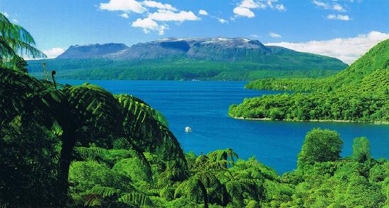
Tarawera, with Lake Tarawera in the foreground
The Kaharoa tephra came from Tarawera. The mountain is not particularly pretty (unlike the surrounding lakes) but deceptively dangerous. Taupo, to the south, is well known for the size of its eruptions. But Tarawera has history too. The overlapping calderas, each from a slightly different location, show that its behaviour is similar to nearby Taupo. The figure below compares the volume of the large eruptions from both regions. (The bars give the magma (or DRE) volumes: to get the VEI values, multiply by 2.5.) The Tarawera area (Okataina) never did anything as bad as the Taupo Oruanui eruption, 26,000 years ago, which reached VEI-8. But it has reached VEI-6 on many occasions, and managed at least one VEI-7.
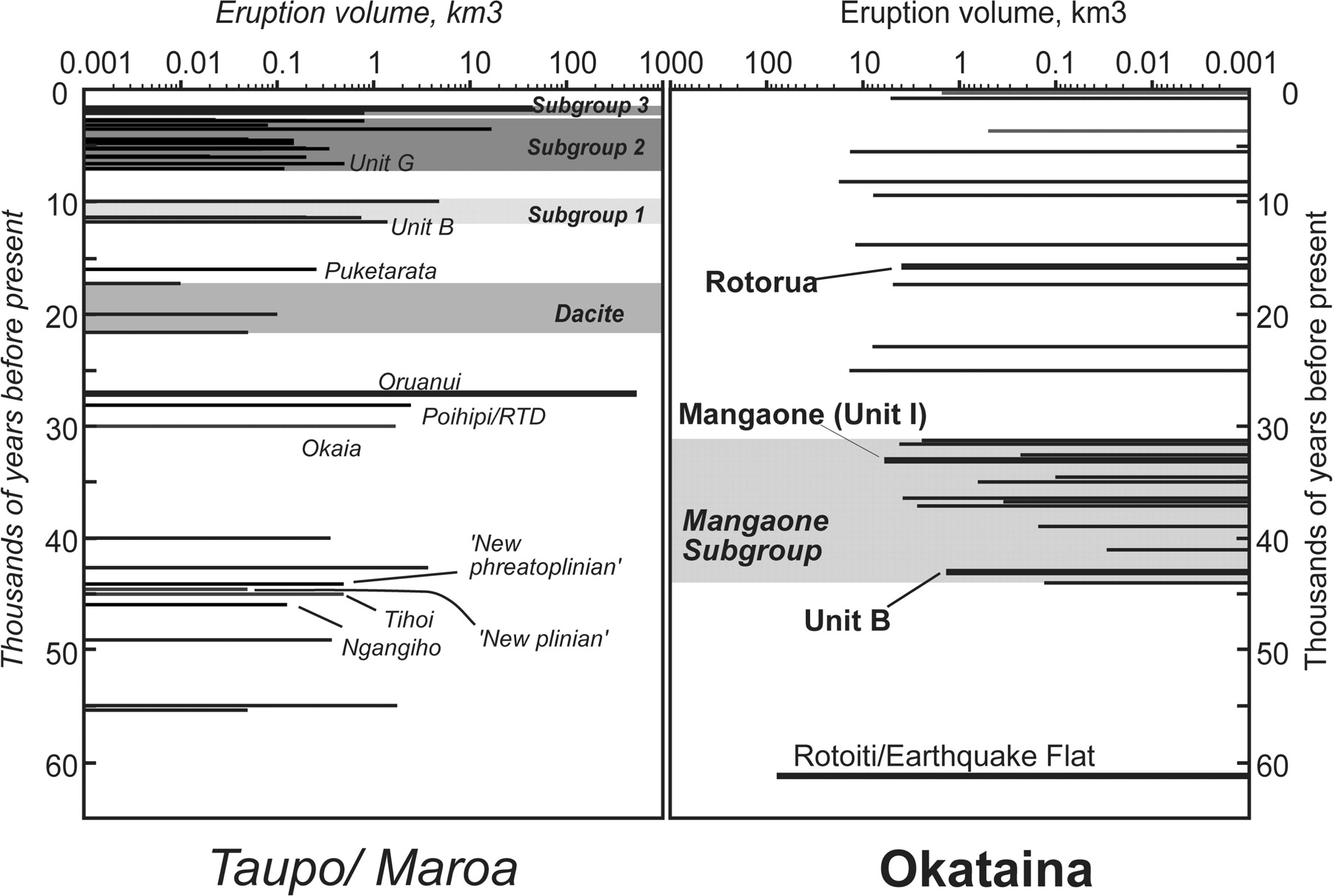
Magma eruption volumes for the Taupo and Okataina calderas, for the past 60,000 years. From Charlier & Wilson, 2010. Taupo is left, and Okataina (including Tarawera) is right.
Tarawera is mostly a rhyolitic volcano, albeit one where basaltic and rhyolitic magma can mix. The Kaharoa tephra is seen as a white, rhyolitic layer. On the slope of the mountain the tephra is 40 meters thick. Even 60 kilometers away it is still 10 cm thick, and it can be seen beyond 100 km distance.
The eruption that caused it occurred over many distinct phases. The tephra forms 13 separate layers from 11 explosive events, with the ash blown into different directions, mainly to the northwest and to the southeast. The eruptions were plinian to sub-plinian. As all Tarawera eruptions, it occured along different vents along a roughly northwest-southeast rift: for this eruption the rift was 8 kilometers long with at least four major vents. Each separate event may have lasted hours to days, based on the thickness of each tephra layer. There is no evidence for any erosion between the layers. Pyroclastic density currents and ashfall between the layers shows that there was a little time between some of the explosions, but this may only have been a few days. The explosive phase may have lasted in total as long as a month or two, or as little as two weeks. In either case, this was not a singular 4-hour event like the 1886 eruption.
The carbonized tree stump used for the dating showed a fully formed year ring below the bark, which indicates that it died during the New Zealand winter, between May and September. The burned trees are found at the bottom of the deposits, and it appears they were killed during a pyroclastic flow from the first of the explosions. The debris from the first set of explosions were blown to the southeast by a constant high-altitude wind. High-altitude winds in New Zealand are normally westerly, and southeasterly winds tend to be brief. This suggests that this winter eruption did not last long. The following layer (H in the alphabetical ordering of the layers) shows evidence for a changing wind during the eruption. The layers above that, which were ejected later, were blown into a north to northeasterly high-altitude wind. These wind directions are more common in early spring (September-October).
After the explosive phase ended, four large lava domes and one lava plug were formed. This will have taken much longer. A typical eruption rate for silicic lava eruptions is 5-10 m3/s, and at these rates the domes may have taken several years to form. These domes survive as the three peaks on the flat summit of Tarawera, and were split apart in the 1886 eruption. (The fourth dome was buried by the other ones, and revealed only by the 1886 rift.) The domes obliterated the craters formed by the earlier explosions. The explosions were probably the openings of the conduits that subsequently formed the domes.

From Lowe & Pittari 2014. The white deposit is the Kaharoa tephra, with clear layering. The dark layer above is the 1886 Rotomahana mud, and the yellow material below is the Taupo 230 AD eruption. The mountain in the background is Tarawera.
How large was the eruption? Studies have yielded surprising answers. The distribution of the tephra suggest that for the largest two or three of the explosions, part of the ejecta fell into the sea. Indeed, Kaharoa ejecta have been found in sea sediment. The thickness of the ejecta layers are measured at different distances from the volcano, and a function is fitted to determine how quickly it falls off with distance. That function gives the total volume for each layer, and includes the part that ended up at sea. There are many uncertainties. The thickness may have been measured at the most obvious places, which is where the layer is most clearly seen. But that may just be where it was a bit thicker, perhaps due to wind or movement by water. And different layers have different distributions, as the wind changed, perhaps even during the eruption.
The measurements indicated that the total erupted volume was around 5km3 DRE which included the lava domes and the tephra. (Note that ‘DRE’ stand for Dense Rock Equivalent, and is the volume of the crater that forms. The ejecta have a large volume because tephra has a low density.) This was a substantial eruption, where the explosions together were a high VEI-5, with a tephra volume not far below 10 km3.

From Sahetapy-Engel et al, 2014
A re-measurement in 2014 increased the number substantially. This study measured and fitted each layer separately, and derived volumes for each of them. The numbers are in the table. The authors calculated a DRE volume of over 7 km3 in the explosive ejecta only. Adding in the volume of the lava domes, the total became 9 km3 DRE. The explosive phase had a tephra volume of 15 km3! The means that the explosions together added up to a VEI-6. The individual explosion were of course smaller, with the largest ones producing between 2 and 3 km3 of tephra.

Source: Nairn et al. 2001
Where had all this material come from? Explosions this size should leave substantial craters. But in this case instead of a single VEI-6 there were 11 VEI 4 to 5’s spread out over an 8 kilometer rift. This makes the individual craters much smaller. They were later buried by the growing lava domes. Still, 9 km3 DRE even over an 8 km rift should leave a hole of 1 kilometer wide and 1 kilometer deep. But the mountain is only 1 kilometer tall. There may have been a series of older domes, blown apart by the explosions, but even so it remains hard to accommodate this much material. The older value of 5 km3 DRE is easier to understand. (In comparison, the Taupo eruption of around 230 AD produced about 30 km3 DRE.) The large proposed volume of the Kaharoa tephra requires confirmation.
In either case, this eruption was the largest one seen in New Zealand since the arrival of the Maori. It covered Tarawera’s slopes in 40 meters of lapilli, and devastated some of the best coastal land of New Zealand, within decades of the Maori arrival. It must have made the South Island, in spite of its colder climate, seem very attractive compared to the ruins of the North Island. Once burned, twice shy. Perhaps this is why for the first 200 years of the Maori presence, most of their settlements were on the South Island: New Zealand’s volcanoes are all on the North Island whilst the South Island is volcano-free – but it is, of course, earthquake-prone. In New Zealand you can’t win. Unless you are a rugby fan.
Perhaps the haka is really a Maori chalenge to the volcanoes of the north, in memory of Tarawera?
An ice core date
We can try to further narrow down the date for the Kaharoa eruption. An eruption this size should show up in the ice cores of Antarctica. Does it? Strangely, no one has looked. They should have.

The plot shows the monthly sulphate profile obtained from the ice cores. The blue line is for Antarctica (WDC06A, from Stigl et al.) and the red line is for Greenland. Tropical eruptions should show up in both ice cores, but eruptions in temperate regions tend to be only be seen in their own ice core. The tropics with its high troposphere forms an effective barrier to sulphate put in the stratosphere at high latitude. For a large eruption in New Zealand, the sulphate should show in Antarctica but not in Greenland.
There is only one sulphate peak within the allowed time period of the eruption, and it is seen in Antarctica only. The peak is not clearly seen in the annual data, where the sulphate in the ice core is averaged over each year. There is a peak but it is far from obvious and not certain. When I first looked at the ice cores, my detection algorithm rejected it. But here I am plotting the monthly data and this picks up the peak much better. It indicates that this eruption was a brief one, lasting only a fraction of a year. The sulphur declined within 1-2 months, and was gone completely after 5 months. The eruption had reached the stratosphere, otherwise it would have lasted no more than a few days. Over the next few months, the sulphur slowly came back down to the troposphere and rained (or snowed) out, and the ice signal ceased.
The peak occurred in the early (southern) winter of 1306. The sulphate began to increase in May or June 1306, peaked in July, and declined, with a second peak in September. This is consistent with what is known about the Tarawera eruption. As one interpretation, it could put the first set of explosions, when the wind was to the southeast, in May/June, and the second set, when the wind was northwest, in August/September. However, this may be optimistic as weather patterns also play a role in determining when the sulphate could have arrived in Antarctica. It is difficult to distinguish eruption patterns from weather patterns.
In any case, the ice core provides a solid date for the eruption. Tarawera exploded around June of 1306.
Burning ice
The ice core does not only show the volcano. It also shows the activities of the freshly arrived Maori. After their arrival, New Zealand suffered forest fires on a scale it never had before. The country is in principle not highly flammable, as it does not have the extreme weather patterns of Australia. Now, the trees went up in flames as the Maori saw them as surplus to requirements. The smoke reached into the sky, and was blown all the way to Antarctica. It too ended up in the ice.
The black soot from forest fires normally drops out of the atmosphere within a few days. In the southern hemisphere, much of it ends up in the oceans. However, some can reach Antarctica. The large annual fires of the subtropical regions of South America and Africa can dump a small amount of soot over the coast of Antarctica. Fires in Patagonia and New Zealand can also do that, but much more of their soot reached the Antarctic Peninsula, blown there in just a few days by the roaring westerlies of the Southern ocean.

From McConnell et al. 2021, Nature 598, 82
A recent paper looked at carbon in the ice cores from Antarctica. The data is shown in the plot, with black for the Antarctic peninsula (nAP) and red for the coast of Antarctica (DML). The time runs from 1AD to 2000 AD. The approximate time of the arrival of the Maori is indicated by the dashed line. The annual amount of soot at DML was relatively constant over that time. It is a little lower after 1500 AD, perhaps due to less burning in South America after the arrival of Europeans. That is an interesting problem in itself. The peninsula record, in contrast, is very different. It spiked around 500 AD and again around 1100-1200AD, followed by a large increase starting around 1300 AD. The early spikes are attributed to burning in Tasmania. The big increase and the higher level afterwards are from New Zealand. The Maori were clearing their new land.
The sharp sudden increase is consistent with the arrival of a significant human population. If only a few tens of Polynesians had colonized, the increase of burning would have been much slower. Instead they arrived in much larger numbers, in a planned settling of the new land. It was indeed a ‘great fleet’. And the onset of the fires can also be measured from the increase. It started in 1297+-30 AD.
The onset of the fires agrees well with the evidence from the Tarawera Kaharoa eruption. It doesn’t answer the question wether the Polynesians arrived before or after this eruption. However, an arrival a few decades before Kaharoa, perhaps around 1280 AD, fits perfectly well with the evidence from the carbon soot of Antarctica.
The ending
The story has brought us a long way, from the shores of Taiwan 5000 years ago and the shores of South America 900 years ago, to the arrival of humanity (and mammality) in New Zealand and finally to the shores of Antarctica. It gave us a precise date for the largest eruption in New Zealand during the presence of the Maori: May/June 1306 (you read it here first!). The Maori did not find an island paradise. During their first decades in the new land they suffered not just one major eruption, but two, when the destructive Kaharoa eruption was followed by the Loisels pumice. The Bay of Plenty would have looked very different and distinctly uninviting during those years. But the Maori too played their part. Just as the volcano spread its ash across the land and beyond to Antarctica, so the Maori spread their soot equally wide. Neither volcanoes nor people cleaned up the mess they made.
New Zealand has changed forever. New Zealand was the last major land mass ruled by the birds. I regret not being able to see the moa, or the gigantic eagles which hunted them. These birds had created a land akin to the world of the dinosaurs, which we have lost. The past is in the past, and people needed to live. But New Zealand is not just shaped by humanity. Volcanoes too have played their part, and their legacy can be seen in many places. The soil of New Zealand is the ashtray of the country, which still contains the ash of volcanoes past. That 700-year-old white band in the black soil tells us a story from a forgotten time, when people traveled halfway across the globe into the unknown, to go where none had gone before, to explore new worlds and to build new civilizations. We have seen nothing like it since. Tarawera is forever part of that adventure.
Albert, December 2021
What could have been
References
Peopling of the Pacific: A Holistic Anthropological Perspective. Patrick V. Kirch, Annu. Rev. Anthropol. 2010. 39:131–48
Paths and timings of the peopling of Polynesia inferred from genomic networks. Alexander G. Ioannidis et al, Nature 59, 522–526 (2021)
Hemispheric black carbon increase after the 13th-century Māori arrival in New Zealand. Joseph R. McConnell et al. Nature 598, 82–85 (2021)
Deposition and generation of multiple widespread fall units from the c. AD 1314 Kaharoa rhyolitic eruption, Tarawera, New Zealand. Steve Sahetapy-Engel et al., Bull Volcanol 76, 836 (2014)
An ashy septingentenarian: the Kaharoa tephra turns 700. David J. Lowe and Adrian Pittari, Geoscience Society of New Zealand Newsletter 11, 1-13 (2014)
Distribution, stratigraphy, and history of proximal deposits from the c. AD 1305 Kaharoa eruptive episode at Tarawera Volcano, New Zealand. Iain Nairn e al., New Zealand Journal of Geology and Geophysics, 44, 467-484 (2001)
Chronology and Evolution of Caldera-forming and Post-caldera Magma Systems at Okataina Volcano, New Zealand from Zircon U–Th Model-age Spectra. B. Charlier & C. Wilson, Journal of Petrology, Volume 51, Pages 1121–1141 (2010)
A post on Taranaki, the most frequent New Zealand eruptor during Maori times, can be found at https://volcanohotspot.wordpress.com/2021/11/15/mount-taranaki-new-zealand/


Hlaup has started at Grimsvotn, article in Icelandic, giggle translate works ok’ish this time, pictures included https://www.visir.is/g/20212190490d/svona-er-stadan-i-grimsvotnum-sed-ur-flugvelinni-hja-rax?
It increases the chance of an eruption. But I am not sure that Grimsvotn is quite ready to erupt.
I left my thoughts about the matter under the previous post. Summary: I’m not convinced jökulhlaups are triggers for eruptions. I think it’s the other way around.
Tomas Andersson
Yes as you say mostly the way around, eruptions triggers these floods .. glacial floods are indeed normalt not the triggers for an eruption.
But sometimes an overpressurized chamber may blow with water pressure removed from it.
But I also doubt it as you says in general, but 2004 blew after removal of pressure, of perhaps random after the flood?
I’m saying 2004 was already well on the way. Earthquake activity was really picking up and I mean that maybe the increased geothermal heat from the impending eruption set off the hlaup just days before the actual eruption started.
How thick was the ice sheet in 2004?
Excellent post Albert! Yes New Zeeland is amazing, and retains the prehistoric cretaceous looking gondwana forests, before the humans and mammals came in, New Zeeland really was a lost world, a dinosaur Island, with giant birds filling the Megafauna. New Zeeland itself haves a long and complicated geological history. Perhaps New Zeeland is similar to the first protocontinents that formed during archean
And here is Latest Photos from Grimsvötn
https://www.visir.is/g/20212190490d/svona-er-stadan-i-grimsvotnum-sed-ur-flugvelinni-hja-rax?fbclid=IwAR3ATZ47fCvWzK8VN0MIOqlJRbjetdb4lyNNMYxBDMNXFMYSujzCZH219Y4
Northen New Zeeland also haves a fantastic subtropical oceanic climate
Auckland is pleasant all year around, like a giant version of Azores or Madeira. Oceanic Subtropical Climate is a very rare climate, limited to small landmasses and Islands in latitude 30 s far out in the ocean, Northen New Zeeland coud be the only example as a larger landmass with that climate
You do get to live in the middle of a volcanic field..
The volcanic field aspect is one of the more interesting parts of Auckland, I’d say. At least most of the time the volcanic field just sits there, looking pretty; fortunately there hasn’t been a eruption in centuries, although the most recent eruption, Rangitoto, was the largest.
The Azores are also wonderful, and that’s not even mentioning the impressive volcanic landscapes, including such scenic spots like Sete Cidades.
That said, in terms of volcanic hazards, the thought of the “urban volcano” definitely keeps me up at night. Auckland is clearly not the only city built on top of a dormant volcanic field and/or immediately adjacent to a significant volcano, and being in an intraplate volcanic field, Auckland probably has a better situation than some of the cities I am about to name, which are in subduction-related volcanic arcs. These include Managua, the southern portion of the Mexico City metropolitan area, and coming in with what is likely the most severe hazard, Naples. Plenty more examples seem to exist across the volcanic arcs of western Latin America, including San Salvador and Quito, although I’m not sure of the extent to which monogenetic vents (or the potential for such vents to form) exist in the cities themselves. The rift valleys of East Africa also seem to have plenty of examples, such as Goma and Awassa (and I do think that the Ethiopian rift in particular needs more study given the existence of multiple large calderas).
Instruments are back on Grimsvötn
Yes its still dropping the caldera water levels link here:
http://brunnur.vedur.is/gps/grimsvotn.html?fbclid=IwAR12B1FQrWt7ayPlAOdrH0YJm6MUSduk0zt6b6ZASH1pR2s-Ru3vbX5m0yQ
Jesper, did you see this link?
http://husbondi.rhi.hi.is/gvth/drainage.html
It’s another GPS (GVTH) on top of the ice. Along with the GPS positions, there’s also graphs with estimates of the current discharge per second and cumulative discharge since the beginning of the event. Discharge numbers are derived from the GPS position, so there’s probably some margin of error there.
If the pressure is very high in the magma chamber a glacial flood can blow it with removal of pressure. But example a glacial flood after a Grimsvötn eruption wont do anything at all to the magma chamber thats not pressurized at that moment.
Looking at the CSM plot perhaps Grimsvötn is not ready for an eruption yet. But Iceland geologists have confirmed lots of inflation pressure since 2011 and gas emissions are very high now. So the volcano is probaly ready to erupt
Lovely and thoroughly researched article. Many thanks, Albert. I really appreciate it! I wonder what the near future holds for New Zealand, volcano-wise?
Based on past frequency of eruptions, Taranaki would be the most likely next one to go
https://twitter.com/krjonsdottir/status/1466114041131188226
The Jökulhlaup from #Grímsvötn has travelled through the glacier and is now measured as an increased water level in Gígjukvísl outlet river. We expect the flood to go on for days and reach its maximum in 4-6 days. We measure flood tremor and the ice shelf has subsided some 12m.
https://twitter.com/involcan/status/1466111791277264899
Strong strombolian activity at 18:25 canarian time
Beautiful piece I enjoyed with some sadness for the Moa (great pic). I didn’t know these and am adding it for others who might not know the people either:
https://en.wikipedia.org/wiki/Chukchi_people
I was wondering why they would take down forests by fire. They needed them for building and for the canoes. Are you sure it wasn’t lightning or volcanoes?
The fires increased manyfold after arrival of the Maori and stayed high for centuries. Lightning or volcanoes would not have done that. I am afraid it was a destructive form of land management.
Is there still too much deep quakes?
Because some people are saying it is better now and it is dying.
Besides that, what is the reason for 2 completely different “explosive” vents?
Now I understand why there is an explosive vent and an effusive vent: The explosive vent degasses the magma and it flows back into another hose where it exits effusively because it just lost its driving power.
But why the heck is there need for a strombolian vent and an ashy one?
How is that separated so neatly in the first place? How can’t get ash into the strombolian vent, and why can’t incandescent lava exit the ashy vent??
Presumably the explosions opened up the conduits. After that, gas could escape and the pressure was enough lowered that the eruption became effusive. The shape of the domes show that the lava was very cool, and very viscous. Even above ground it just remained a big blob. The explosions happened all along the rift, opening up several craters. The cold lava below it came up very slowly (thinks squeezed honey), months later.
I think they were not any better than we are, they ate up everything, also on Easter Islands:
“Deforestation also caused erosion which caused a sharp decline in agricultural production.This was exacerbated by the loss of land birds and the collapse in seabird populations as a source of food. By the 18th century, islanders were largely sustained by farming, with domestic chickens as the primary source of protein.” This from wikipedia about the islands that were supposedly settled between 300 and 1200 AD.
They were good at navigation and canoe-building, but obviously they didn’t think one minute about hunting when breeding is finished and leaving out a few months. And theories about Easter Island (i.e.Jared Diamond) say that deforestation leads to Nirwana. Other impressive examples he mentions are Haiti, contrary to Dominican Republic on the same island, and also Ruanda.
I liked the novel Hawai’i by James Michener. It’s a novel though, so needs to be taken cautiously, but he did a lot of reaearch before writing. He had the idea that they might have taken off regularly and reached Hawai’i by doing so because of human sacrifice. He also mentioned that they were brillant in star navigation. He describes a tsunami perfectly in that novel.
I learned some from that novel and also from Michener’s “The Covenant” which shows what Zulu-Emperor Mzilikazi did to the Durch settlers who then started taking revenge. The root of the South-African problem which the British tried to mediate.
So, no human society ever was an angel. Best, indeed, to try to solve some problems together nowadays. The guilt card has to go though. Everybody is guilty for s.th.
Of course. Humans are actually all much the same and its very likely that population growth and consequent limiting of per capita resources led to pastoralism and later agriculture. Agricultural populations were smaller and less healthy that the hunter gatherer populations that preceded them.
Today a small (fraction of a percent) of the human population is aware of what the future will bring and would do what is needed, but since the rest neither know nor care we will have trashed the planet before we sort the problems out.
This will mean a return to middle-age (ie tribal warlords or petty kings) society and energy consumption and a drop in world population to a few hundred million. The transition will not be nice. The cause is actually overpopulation and migration will topple egalitarian westen societies that already cannot give their populations what they think they deserve as of right.
Then food production will crash, exacerbating everything.
Hey-ho for humans , eh?
Actually it was Shaka’s brother Dingaan who started the I intial problems with the Dutch settlers when he had Piet Retief and his delegation murdered. Mzilikatzi was an outcast Zulu General who made the generally fatal mistake of attempting to hold back on handing over some captured cattle. Mzilikatzi fled with his followers into the hintererlnd of South Africa and generally caused mayhem with the locals. He was pushed further West by Shakas armies and set up camp on the now Botswana South African border. It is here that he ran 8nto the Dutch settlers moving North. He was eventually defeated and moved North East int what is now Western Zimbabwe, his dependents are still in that area and are known as the Matebele.
Tnak you for putting this into a more precise context.
Strange. Thanks of course.
Every nation tried to present its own history from the most favourable angle. We learned little about the Dutch colonies in school. Slavery was not a Dutch invention but they did make a lot of money out of it. The dutch government enacted a law forbidding taking the local population into slavery. That law allowed taking them elsewhere and selling them there. Thus the Malay in South Africa and the black people in America. I believe England did the same. We never learned about the war in Indonesia. We did learn about the Boer war when the English ‘helped’ the Afrikaners by helping themselves (or Cecil Rhodes) to the diamond and gold mines, a bit of history presented very differently in England – both sides would leave out inconvenient details. The same in the current disputes in the US where both sides focus on the other side’s faults while whitewashing their own. People are not angels. But they are capable of amazing things. We are not all bad.
Q: Might this have added to the Great Famine 1315 and its smaller predecessors?
I had wondered about that but decided not. The eruption was too small and in the wrong hemisphere. I don’t think that famine was volcanic.
Albert the CO2 levels are rising very fast because of human activities.. do you think Northen New Zeeland will turn tropical soon? Only a little raising of winter temperatures is needed. NZ been tropical before earlier in the cenozoic. But I guess the massive massive Antartica Icecap still haves a cooling effect, even if the CO2 reach 2200 PPM by year 2300.
That Ice will take time to melt
Thank you Albert for all that detail and careful scientific explanation. I particularly liked the pictures of the ash layers and how scientists handle such data and you have done an excellent job with the maps and pictures. Thanks!
La palma, yesterday earquakes put them to the second day with more activity.
The tremor level.
The lava falls by the flanks
RSAM is on the rise, and thus volcanic activity too. Quite unpredictable this eruption, as most eruptions are. Hard to know when it will end.
https://twitter.com/ita_dc/status/1466332326611271680
Activity during the night…
A great read as always Albert. Thank you for adding lots of new details to a story I thought I knew reasonably well.
As well as conquering the Pacific, the descendants of those first Taiwanese voyagers also made it to Madagascar. Absolutely incredible navigators.
That seems easier than crossing the Pacific Ocean. They were always able to stay close to the coast.
That way they also always had enough food and water. The Indian Ocean is smaller anyway. The Pacific is huge, and the chronist of Maghalaes who survived had some stories to tell about the missing wind and dwindling food and water.
Thank you for this superb article, I learned a lot.
This article, BTW, holds something I’ve been looking for for a long while; mention of a South American genetic signature in Polynesia. I’ve long been interested in the reports of pre-Columbian chicken bones in South America and other clues to precolumbian contact between those groups. My theory is that if the Polynesians could find and settle Easter Island, they also had the ability to reach South America. My theory is that they did, at least as an exploration voyage. The sweet potato, and some other South American plants found widely in Polynesia, indicate this.
Regarding large stonework in Polynesia… while not on the scale of Easter Island, Yap Island (in western Polynesia) is interesting. The Yap Stone Money, the Rai, was often enormous in size (one specimen clocking in at four tons!). What’s even more amazing to me is that these giant pieces of stonework were not made on Yap, they were quarried and cut on Palau, 300 miles away, and then transported to Yap, long before European contact.
I’ve also long wondered whether the reason that long-distance trade declined was an exhaustion of suitable trees. From what I’ve read, and what I know of sailing, the Polynesian voyaging ships were big catamarans, thus requiring two very large (in both diameter and length) trees. If those trees were no longer available, they’d have had to build smaller, less-capable craft – thus less suitable to long voyages and trade.
BTW, one of the places ancient Polynesians mined for both fine-grain basalt and volcanic glass was Pitcairn Island. Regards the latter, it’s, so far as I know, the only known source of volcanic glass in eastern Polynesia.
There certainly has been contact with Americans, but probably only once. Where this happened remains a mystery: the chickens and the sweet potato suggest it was in America but both have been disputed. The evidence for pre-colombian chickens is inconclusive, and the sweet potato may also have spread to a few of the islands long before humans evolved. There are arguments either way. We do know the ‘when’ (around 1200). We also know that Easter Island was not involved. And only the Polynesians had ocean-faring ability: Americans never did. As for the decline, the two most likely causes are conflicts and resources. Both probably played a role. Lack of trees for canoes must have become a major problem on the smaller islands. Places like Pitcairn and Henderson depended on other islands for this, and when trade with those islands stopped, their populations went extinct. Easter Island did survive after they no longer had canoes, but only because it was a more fertile (volcanic) island where agriculture provided a viable alternative.
Birds can also spread seeds. And the wind. So the inconclusiveness makes sense.
La palma dron flyby 8:15 local
https://www.youtube.com/watch?v=CxkIrBPrDKk&ab_channel=CabildodeLaPalmaendirecto
Copernicus EMS
https://twitter.com/CopernicusEMS/status/1466328398037491715
And other maps
https://twitter.com/x_y_es/status/1466327023807348737
La palma, heat map by drone flyby.
Eruptions on the Cumbre Vieja occurred in 1470, 1585, 1646, 1677, 1712, 1949, 1971 (and now).
The whole west coast is full of lava plateaus. I saw some pictures from the past. The banana plantations (and houses) are mostly on those plateaus in front of the steep cliffs. So basically, this is next to normal. It’s a longitudinal rift. Tenerife and El Hierro are sitting on a triple rift.
The long gap between 1712 and 1949 might have given them the illusion of security. They will be able to live there, have plantations, have a new start. But one day this will happen again.
As this is a rather long eruption with lots of lava it might take another 200-250 years though.
On this pic it’s clearly visible that all of the island is built on Lava:
They will build it up again. Better than to live in the suburbs of Madrid as volcanoes are ewesome.
https://twitter.com/TheWatchers_/status/1466366797716672512
Major explosive event at Sangay volcano, ash to possibly 15.2 km (50 000 feet) a.s.l., Ecuador
Wonder if it was given a helping hand by the big earthquake in north Peru earlier in the week? It usually does strombolian VEI 2-3 semi-regularly, has done for about 500 years.
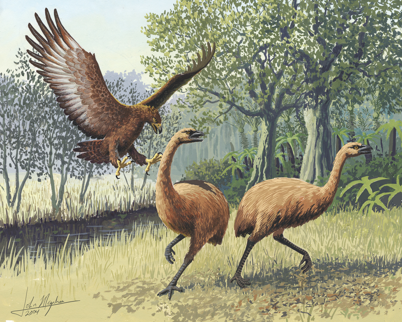
Moas & Haast’s Eagles:
Bald Haast’s eagle feasted on moa guts
https://phys.org/news/2021-12-bald-haast-eagle-feasted-moa.html
—
You must wonder if a very few Haast’s made it to America, inspired the ‘Thunderbird’ legends. Or were T-Birds ‘merely’ Andean Condors ??
Interesting article, thanks for posting the link.
btw, the possible Andrean Condor/Haast Eagle/T-Bird connection would never have occurred to me. Fun.
Hieraaetus moorei Did indeed become extinct because their prey, Moa became extinct too by human hunting activities. Birds tends to grow large on large isolated islands where there are empty niches. In Carribean there evolved large flightless killer owls in the Pleistocene to feed on giant rodents another example.
Perhaps Hieraaetus moorei was going that path too, becomming even larger and flightless.. basicaly evolving back to the giant ground eagles that was the raptorian dinosaurs 🙂
I can’t avoid noticing that this setting
reminds me of some pterosaur hunting scenes.
Well petrosaurs are not dinosaurs really, they evolved from another group of reptiles, they evolved almost mammalian traits as meozoic time vent, furry skinn and good colourvison and endothermy. By the KT boundary flying reptiles specialy the small ones, where so evolved in their linage that they hardly looked reptilian anymore
Althrough colourvison is a typical avian and reptilian trait, the mammals lost it as they became nocturnal, most mammals today are colorblind.. the primates reevolved it in the eocene.
Therosaurs / petrosaurs with diurnal reptilian ancestors almost certainly had good colourvison.
Thats an amazing painting
You need this book:
https://www.designweek.co.uk/inspiration/paleoart-visions-prehistoric-past-zoe-lescaze-walton-ford/
He might have left some traces:

Oviraptor, not from the book
Thunderbird legend was probably from early encounters with teratorns, which were closely related to condors but probably more carnivorous and predatory. Most teratorn remains are of Teratornis (hence the name) which was similar size to a condor, probably bit bigger on average. Aiolornis was a closely related genus but much bigger, 5.5 meter wingspan, probably the biggest flying bird encountered by our species.
In terms of appearence teratorns probably looked a lot like a caracara, rather than a vulture, prefering to hunt on the ground and being competent runners. Primates also have a deep instinctive fear of birds of prey, something that our species is largely too big to worry about but in this case that need not apply… Teratorns were not found in Eurasia, where most of the mammalian carnivores were found pretty much worldwide, the first Americans would have been familiar with lions and wolves, maybe not Smilodon but close enough to a lion to get the idea. A flying carnivorous bird big enough to look a grown man in the eye though, that would have been entirely a new thing.
It might be relatively new that we are not afraid of birds of prey, but protect them instead. When I was small there were still legends in fairy tales, that eagles could steal babies from the garden. Legend of course.
And then there is the tale of Sindbad (Arabian origin) who once was taken away by the bird Rock, a giant. In another tale he lands on an island which turns out to be a gigantic whale.
I believe that people found giant fossils and thought they were from animals present, hiding somewhere. The Valley of the Whales in Egypt would have given the idea to the Arabian tale.
There are cases of crowned eagles attacking children in Africa, the same birds were quite known to prey on Australopithecus and in modern times will take impressively large prey. We are much bigger and more powerful than Australopithecus but only as adults (it is a bit of a myth we are weaker than other apes, we just tend not to use our full potential)
It is also well known eagles worldwide will attack and kill prey that is as big as deer and goats, and even adult kangaroos, we probably take our great intimidation bonus from standing upright a bit too much for granted sometimes, it is likely the single biggest reason we survived long enough to invent tools. I imagine our early ancestors were probably hyper agressive and dangerous and formed large social units, like baboons today but more predatory especially in later iterations of Homo. I doubt many predators would dare risk attacking such a unit in the day, and probably more than a few predators had the tables turned on them. The only record of cave hyenas in Europe interacting with our species for example has us as the predator not the prey…
We are more now, and they might be aware of the fact that man has guns. The fox knows it.
A good map of CAMP in here. I imagine the Solnhofen creatures developped after CAMP – some ancestores might have survived being not too close:
https://www.nature.com/articles/s41467-021-25510-w/figures/1
https://www.nature.com/articles/s41467-021-25510-w (article)
And a link about some reasons why the JK-extinction might be underestimated. The Solnhofen fossils belong to that period:
http://fossilsandshit.com/why-i-think-the-jurassiccretaceous-boundary-is-super-important/
I remember that bushmen, hunter-gatherers that lived in the Kahalahari Desert, had some tactics to avoid being predated by lions, and which apparently worked quite well because lions didn’t really eat them. They knew the times of the day that lions used to hunt and avoided them as much as possible. Lions prefer early in the morning when its not too hot, so gatherer women used to wait until they were done hunting before going out of the camp. Human camps are usually well protected at night too, someone is always vigilant by the campfire while the rest sleep, the tents in which people sleep keep away predators too, who probably do not understand how to deal with them. If a lion did wander into the camp at night them they would take branches in fire and scare them away.
For the most part predators were not such a big problem to hunter-gatherers of the Kalahari. First because they are spread out very thinly in the wild. It’s not like you would run into an animal as soon as you walk out into the veld, for the most part the wild is a vast emptiness. Bushmen also had excellent tracking skills and a knowledge of animal behaviour that greatly surpassed that of zoologists now. Still though sometimes it did happen that they were predated. Hyenas picked up vulnerable individuals who were alone like children or the elderly. Leopards were the main predator but would only try if they could catch the person off-guard, as soon as they were discovered they ran away. Sometimes leopards even tried to sneak up into the camps.
By the way, I recommend Elizabeth Marshall Thomas when it coms to books about hunter-gatherers. She spent some time with the Bushmen of the Kalahari when they still did the foraging, although they did already smoke tobacco so there was some influence from outside their way of doing things. I’ve read The Harmless People, The Old Way, and her fiction Reindeer Moon, all of them are quite good.
Great tip, Hector, thank you.
Solnhofen Woud have been a total paradise for any jurassic time traveller, looking perhaps like Maldives or Fraser Island, Europe was mostly flooded during a warm tropical Sea back then. The Hyperactive spreading ridges and Ice free climate pushed up sealevels 100 s of meters higher than today. You woud have hundreds of small coral islands and deeper sea mafic seafloor corridors, but mostly shallow flooded shelf. Jurassic Europe was erhaps similar to a few bahamas today. But in Europe. The warm waters woud have been super clear beacuse of the lack of nutrients, and bone white calcite beaches. Fauna was mostly flying creatures, But small Island dwarfed dinosaurs existed too.
Like this?:
https://www.pteros.com/environments/solnhofen-limestone-formation.html
Take the Pterodactyli away, and Bavarian lakes are still similar, but the artists are of course inspired by what they see today:
“Walchensee fills a tectonic valley, part of the Bayerisches Synklinorium (Bavarian Syncline) and from rocks of the Triassic period (the main dolomite, Plattenkalke, and Kössener layers). The extreme depth of the lake, 192.3 metres (631 ft), is the result of this tectonic formation. The rock faces of the northwestern shore clearly show the steep arrangement of the rock layers. The creation of the lake from the forces of mountain building indicate that Walchensee could be one of the oldest lakes in Germany.”
https://en.wikipedia.org/wiki/Walchensee
Thank you Hector, for the thoughts and book tip
https://twitter.com/xurxosanz/status/1466379776432685058
#LaPalmaVolcano #CumbreVieja eruption dashboard is available
Hahaha looks like a geologist had some brain eruption of data science, why not xD
Thank you for the link though!
Lots to play with!
Thanks. 😁
Thank you both!
Just watching the TV Canarias life stream, you wouldn’t think at times that the volcano is 70 days old.
..hefty…
…and at times it’s looking like it’s deleted the next day.
Appears like the volcano has psychic issues 😮
(or a shortage of magma)
https://twitter.com/volcanodiscover/status/1466454692427403267
Grimsvötn #volcano (Iceland): subglacial meltwater flood started while top of glacier subsides 15 m – The glacial flood (jökulhlaup) from Grímsvötn volcano has started. Meltwater has made its way under the glacier to its exit
The height of the jet tonight has reached a maximum of 400-500 m
https://twitter.com/involcan/status/1466487821112332288
https://twitter.com/ita_dc/status/1466487348229718025
Fantastic write up as always Albert!
Here’s a YouTube tip about unusual earthquakes in Mississippi https://youtu.be/Kn2KFC8cX-g
Check out his video on Mt Paektu, also really good!
Grimsvotn eruption is very near says professor Magnús Tumi Guðmundsson…
https://twitter.com/subglacial/status/1466489747916926981
https://twitter.com/lava_ice/status/1466378803618496512
If inflation is greater now than in 2011
Then the shallow magma chamber have expanded, that thing is getting bigger after each eruption at least after 1998.
Grimsvötn webcams:
http://webcams.mogt.is/?fbclid=IwAR0EILEd7OJXI755aEbG_SEAUtXknc4r4gTn0F_1vWHl485miJeLj6JffH4
He doesn’t say that it’s very near. He just states that it’s not unlikely and that they should be prepared if it happens.
If souch a flood happened directly one week after the 2011 event, there woud not been an eruption because chamber was not pressurized then.
But now 10 years after, and during high supply years, and with good inflation it maybe able to blow it, hopefuly the removal of pressure will start the magmatic gas nucleation process and blow the magma chamber
https://www.ruv.is/frett/2021/12/02/volcanic-eruption-this-weekend-not-unlikely?1
Grimsvötn Latest news
Might be a long shot but are there any cameras pointing towards Grimsvotn?
Not sure they are directly at Grímsvötn but they are roughly in the right direction:
https://www.livefromiceland.is/webcams/jokulsarlon/
https://www.livefromiceland.is/webcams/kverkfjoll/
http://webcams.mogt.is/?fbclid=IwAR0EILEd7OJXI755aEbG_SEAUtXknc4r4gTn0F_1vWHl485miJeLj6JffH4
Cameras over Grimsvötn
Best place to watch If an eruption arrives
Thankyou both.
Not great after 3 at this time of year mind!
How thick was the ice above Grimsvotn in previous eruptions?
Manyof the eruptions on record on GVP website were spring/beginning of summer, probably as the ice was already melting away, but there are a few in there of November/December time. What is interesting is that the winter eruptions look to be often VEI3+, probably because there’s a bit more ice cover and water interaction.
Looks like we are in FAF mode now: Half a day off, 10 minutes relentless full power.
I could observe about 3 cycles until now.
Grimsvötn CSM plot: less steep climb: But perhaps it does not mean a less active system?
If the other instruments shows more inflation and magma now than in 2011, that means that the system is well heated and gives off less Earthquakes than it did before 2011. It appears that Grimsvötn haves competely open conduits below the caldera roof now, and thats why it gives off less Earthquakes, despite being more inflated than it was in 2011 http://hraun.vedur.is/ja/vatnajokulsvoktun/grf_uppsafn.html
Thank you Albert – what a great read.
La Palma: not what I’d want outside my front door …
https://www.instagram.com/p/CW_tDlSr199/?utm_medium=copy_link
It’s falling very fast… -20.26m now…
http://brunnur.vedur.is/gps/grimsvotn.html
A great article.
And a brave one.
The issue of Maori involvement in the extinction of the Moa, is politically (though not scientifically) controversial in NZ.
I remember once saying that the Maori had chomped their way through the Moa to a Kiwi, the result was a wide eyed gasp, a nervous giggle, and the suggestion that “I wasn’t allowed to say that”.
Well, this is a science blog. Let the data speak.
Btw, you have a few children if I got it right. One of them might like the book I recommended to Jesper (they don’t pay me). It’s my honest opinion and the best way to give oneself a X.mas present by giving it to somebody else 😉
It’s beautiful art, most of it not in the internet, rarities.
That’s the trouble these days, nobody wants to face unpleasant facts so they are erased, which means we forget what we never knew. The one that hit me in the face was when Alex Hayley (of Roots fame) explained on a TV documentary how the maritime countries lined up at african ports to buy slaves from the local BLACK traders who ‘obtained’ their slaves from inland. There was no aspect linking colour and slavery then, just as in elisabethan times Moorish slavers enslaved entire cornish and somerset villages and took them to africa.
Slavery and colour is a recent phenomenon, largely encouraged in the USA, certainly the west indians I knew in london in the 60’s did not associate themselves with slaves, although there was discrimination as they were considered (due ignorance) to be as bad as the irish immigrants (who were often a rough lot).
That’s a pity, honestly. I believe that it would be better if every country/people faced its own unpleasant facts as one would see then that none is perfect, earth a beautiful place with a brutal history, and one could work together to get some things repaired.
I would start getting the plastic out of the oceans and forbidding industrial fishing on a large scale, not local fishing of course.
It’s perfectly seen without even touching the worms around deep sea geothermal vents that most life forms always in or around the oceans, perfectly seen with the Solnhofen Lagerstaette.
Being hypocrits doesn’t help.
This is great, Jesper:
from:
https://en.wikipedia.org/wiki/Paleoart
This guy looks a lot like moa:
Same source.
Jesper, I recommended a book to you further up. You’d be happy if somebody gave it to you for X-mas.
I got that myself three years ago, a birthday present früm my daughter. Quite good. I like to look at it.
Recent research suggests strongly that these MASSIVE flyers (I think some were hundreds of kg) could take off from the ground by pogoing off their front limbs and getting much more lift with all four limbs (and the wind muscles are powerful) than birds that just rely on their legs.
Ah here we are, although I think there is much more recent work on this.
https://www.scientificamerican.com/article/how-pterosaurs-first-took-flight/
Thank you for the link. It says they had a weight of 250 to 550 pounds. adult male ostrich has 350 pounds, so we have an idea.
Weight of a Jersey calf: 6 months 259-321, 8 months 335-412
Vampire bats do the same thing now, jumping into the air with all of their limbs. The sight of an animal as big as a giraffe doing this though would have been quite something. Azdharchid pterosaurs were about as close to dragons as any real animal has ever got, some small pterosaurs looked visually much more the part but were mostly the size of modern birds, wingspans under a meter. It is also thought Azdharchids were the only pterosaurs that would be able to properly run, based on limb proportions and range of movement, they probably hunted on the ground.
Hatzegopteryx was probably the scariest of these animals, a robust monster that was more than a match for any theropod in Europe of that era. If other Azdharchidae were compared to storks then Hatzegopteryx was like a shoebill with the build of a cassowary… It was also big enough to eat you and then fly off 🙂
https://prehistoric-life.fandom.com/wiki/Hatzegopteryx
Got to say if this thing had an easier name it would be up in the big leagues, basically this is exactly what movie pterosaurs were except not having teeth.
Thx for the link. It lived in Transsylvania, which was an island then, Hatzeg Island.
We finally know where Dracula comes from 😉
There is nothing (in the Internet) that doesn’t exist.
Thank you for that inception with the link. I often wondered what it might have looked like earlier, when nature was still pristine and untouched!
Didn’t know there was officially such a thing as “Paleoart”, other than the occasional 2, 3 Wikipedia pictures trying to depict depicting createous or some other old time.
Before I got the book I didn’t know it either I guess. And it is old.
Where is the eyes on this giant therosaur?? It looks super creepy!
I guess They are just very small on this scale
It’s art. Picasso’s woman here is sort of creepy as well:
Yes, it is. 😮
This one is discussed as being related to bats:

From:
https://en.wikipedia.org/wiki/Pterodactylus
Eruption during the night and last 24h…
https://twitter.com/ita_dc/status/1466683864957468675
https://twitter.com/ita_dc/status/1466684414381993987
A very good map of the Kimmeridgian, late Jurassic:
https://www.researchgate.net/figure/Late-Jurassic-palaeogeographic-map-showing-location-of-study-areas-Letters-relate-to_fig1_234101577
Letter B is Solnhofen’s assumed location. So, while the largest dinosaurs roamed the Americas and also Africa, archaeopterix and pterydactylos who were the bridge to the future had developped in a Jurassic sea in what’s now Solnhofen, Bavaria.
I won’t make a joke about the brexit.
https://www.youtube.com/watch?v=F5L2EGgvops
Really fast lava going down that slope now. Looks just like the lava flows going into Natthagi in September.
https://twitter.com/krjonsdottir/status/1466707646090723329
#Grímsvötn #jökulhlaup ongoing. Flowrate yesterday afternoon was measured 1140 m3/s. The subsidence at Grímsvötn is now ~25 m. Seismometers show flood tremor.
-25.72m now…
Eruption 09.47h. Strombololian emission persists in the new NE crater. High degassing. Increasing seismic. Max.4.2. Ascent deformation in Jedey of about 8cm.
I feel like I need a scientific explanation why was/is it in “FAF mode” all night long.
Very strange to me.
Is it Albert’s/Carl’s stop and go now? (One of them mentioned something, months ago)
I remember a previous article from Carl, basically saying that Grimsvotn has taken a steadier climb. If the plumbing is stuffed full of Magma, is it possible that the pressure can reduce the Seismic activity? If ice is acting as a cork… Has the pressure “maxxed out” as it were?
https://twitter.com/CSIC/status/1466729600961200132
Lava blocks in the #LaPalma volcano.
The crater experienced yesterday (12/02/2021) the opening of a lava that accumulated large blocks in the upper part, as can be seen in these images recorded by researchers from @IPNA_CSIC
Now that’s what I call a rock!
In German you would say “Aaaaaaaaaaaaalles klar.” upon that boulder xD
Only men. Women say oh, just like omygod in English realms.
La palma: New south lava flow that morning.
https://twitter.com/ita_dc/status/1466757249074966531/photo/2
New south lava flow that morning.
https://twitter.com/ita_dc/status/1466757249074966531/photo/2
Sorry to the duplicate post 🙁
La palma, New lava on Tacande north (that start to see on the drone flyby yesterday).
La Palma, Drone flyby 03 December 8:30 local, appear other lava flow to the south, on the las manchas zone.
La palma, same drone flyby with thermal camera, show all active flows at north and south.
-27.3m now…
http://brunnur.vedur.is/gps/grimsvotn.html
-29.01m…
Inflation on LP03
https://twitter.com/LavaCentre/status/1466790932095897600
This image shared by the brilliant Dave McGarvie shows the deformation of Grímsvötn, as measured by one station at the rim of the caldera. It seems apparent, that the inflation level is double that of the last eruption. No wonder why it is believed we can have an eruption soon…
Wow it must be totaly stuffed with magma!
I put you a link with a pic in it to the Solnhofen setting you imagine further up.
It was the realm of Tethys. We know a lot about Thethys because of Eurasia’s mountainbuilding.
We know next to nothing about Panthallassa, so huge. Plate tectonics, yes, but those islands come and go. Plate tectonics though is life over there.
Solnhofen was a total paradise that was unseen by sentient beings, humans
had not evolved back then,
it probaly looked like a collection of bahamas and maldives. Lots of calcite sand and marine deposition in warm clear oligotrophic seas
But the lagoons where probaly anoxic and perhaps fertile, its the ocean around thats a Clear tropical ”marine desert” Meozoic seas where clear and blue
This is a really good illustration of where Grimsvotn is in my opinion. The 2011 eruption resulted in 30cm of deflation. Since then we have now accumulated 60cm plus of inflation. It’s recovered from 2011 and added an extra 30cm.
Doesn’t this suggest Grimvotn will erupt very soon and that the eruption will have at least as much if not more magma available than in 2011?
Not all the inflation is magmatic. Part of it is the melting of the big glacier. There is now less weight pushing down the bedrock, and therefore the crust is rising as Iceland warms and the glacier melts. This rise can be several cm per year. Around Grimsvotn, it is measured at about 30cm over 10 years (this was from 2004 to 2016). It seems to me that the magmatic inflation is similar to what it was in 2011, not twice as large as claimed here.
You can see the effect of the weight of the ice in the plot of the inflation. It peaks every year in November, when the summer melt comes to an end, and bottoms out in May when the snow reaches its maximum.
So I am afraid that (very apologetically) I do not agree with Dave McGarvie’s interpretation.
No emergency alert at volcano on Reykjanes
The head of the state police has, in cooperation with the chief of Suðurnes police, decided to remove the uncertainty warning in place at the Geldingadalir/Fagradalsfjall volcano on the Reykjanes peninsula. New lava has not flowed from the crater since 18th September. Visitors are warned, however, that the ground remains unstable in the area and volcanic gas pollution is possible.
03.12.2021 – 13:22
https://www.ruv.is/english
La Palma last earthquake 15:37 and the volcano has gone quiet.
Is this a bad sign it’s recharging itself for a stronger earthquake ?
The tremor has none disapear, something comming….
The main cone is glowing …
Gracias Angel .
That is very strangle…. no lava or explosions, no earthquakes and camera not show nothing…. but the tremor continue raising….


A new fisure has incoming or some has raising?
I’m really wondering whether Cumbre Vieja will stop if Grimsvötn comes along. That would be amazing. That’s where the music plays. MOR’s and subduction zones.