It seemed to come out of nowhere. In the midst of a quiet interlude, after the hugely damaging La Palma had ended, when the hugely touristic eruption at Fagradalsfjall failed to re-appear, and the hugely underwatched eruption at Kilauea continued to be underwatched, whilst we were waiting for Reykjanes (which some had predicted to recur on Jan 11 – it didn’t) (yet), suddenly the news came of a large explosion in the Pacific ocean. The ash cloud on satellite already showed this was not a run-of-the-mill VEI-3. It was large. Reports came in that explosions were heard. That is normal in eruptions, but not like this. Deafening noise (sonic booms) were heard in Tonga, 60 kilometers away. People in New Zealand heard it, 2000 kilometers away. Even Alaska joined in, 10,000 kilometers away. This was starting to look interesting. Unique, even, for the 3rd millennium.
The victim was a partially submerged volcano called Hunga Tonga. Sometimes it had been two islands, at other times connected into one. It is not uncommon for such volcanoes to be exactly at sea level. They erupt and the water turns the lava into loose ash and pumice. A cone builds but because it is such weak material, the ocean waves quickly erode it again. As the new land disappears below the waves, erosion becomes less and a plateau just below sea level forms, until the volcano erupts again and the process repeats. This can go on forever. It is also possible a non-ephemeral island will form. This can either because the eruption rate becomes faster than erosion, or because the magma chamber inflates and pushes up the ground. Once the cone is high enough, lava can begin to build a more solid surface, more resistant to the waves. Now a smaller eruption rate can suffice to build something big. Hunga Tonga was never at that phase. It is ruled by the waves.
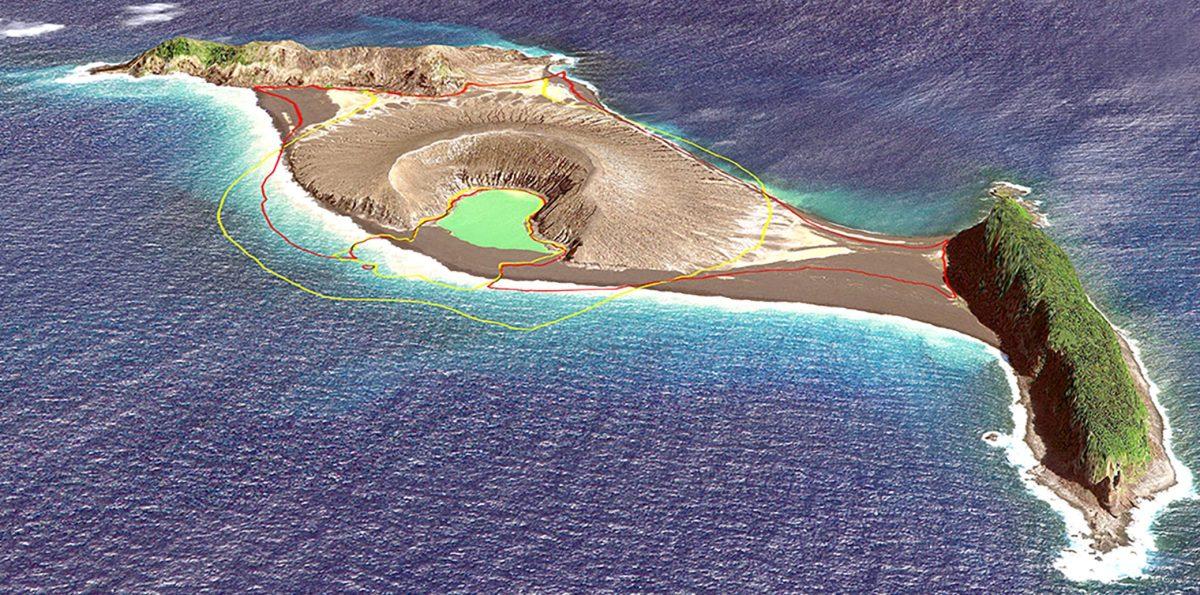
The island is shown below. The cone formed in an eruption in 2015, which filled in the hole between the two parts. It is now gone. The two parts, the two islands that existed before 2015, are called Hunga-Ha’apai and Hunga Tonga. They are ridges a little over 100 meter high and 1.5 kilometers long, with vegetation.

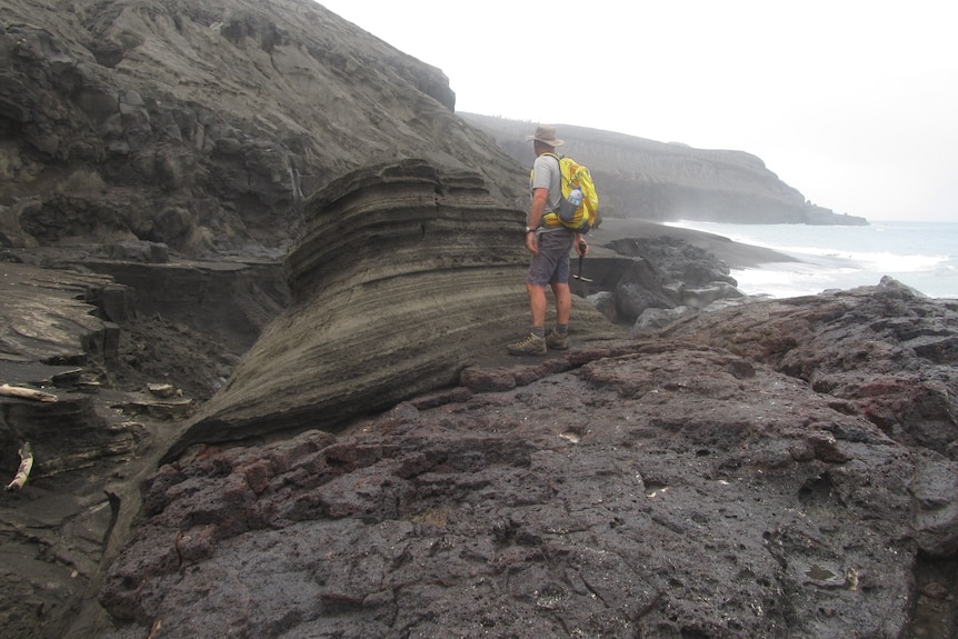
Shane Cronin studied the island after the 2015 eruption. The photo above is from him (taken from https://www.abc.net.au/news/2022-01-16/tonga-volcano-could-erupt-again-says-expert-who-visited-the-site/100759390). It shows the rough eroded side of the ridge, but also a block with thin layers, which originally would have been horizontal before the block fell down. This looks like deposits from pyroclastic flows or base flows. This volcano has done big explosions before.
The map shows two further, very small islands south of Hunga Tonga. Just like the two ends of Hunga Tonga, they show a ridge-like appearance. It is tempting to draw a circle connecting the three ridges, perhaps a remnant of an old crater, 3 kilometers in diameter. Bathymetry done after the 2015 eruption by Shane Cronin confirms the general idea: it shows a deep hole within this ring, partly filled in by the 2015 cone.

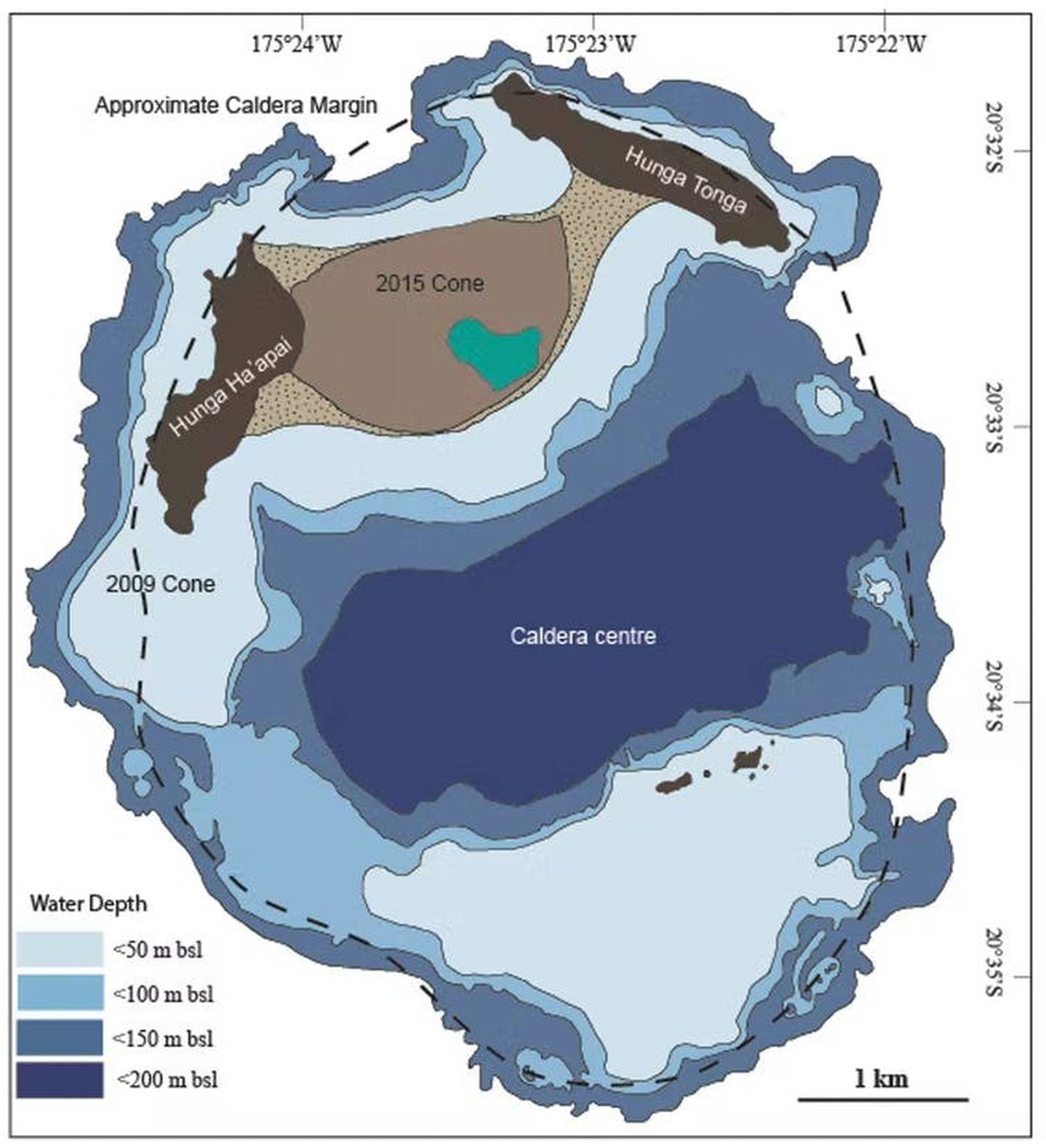
The small islands are seen to be the inner edge of a more extended plateau. The authors interpret this as a caldera with a size given by the outer edge of the plateau. (It had already been suggested to be a caldera in 1972, but this study confirmed it.) I would have taken the inner edge as the size, and go for the smaller caldera; the outer edge is the erosion of the submarine mountain which might even date to the time of lower sea level. There are two underwater domes on the eastern part of the ring which fit this smaller ring. But this doesn’t change the basic idea: this is a volcano which went caldera, and the eruptions are now on the ring fault. The 2009 and 1988 eruption were on the western part of the ring, and the islets on the southern ring erupted in 1912 and 1937.

Source: Cronin, https://eos.org/science-updates/new-volcanic-island-unveils-explosive-past
How big is the volcano? It rises from the sea floor almost 2 kilometers down, and it 20 kilometers wide (from the article by Shane Cronin). There are echoes of Iwo jima here. There is a kraken here.
How old is it? The islands were ‘discovered’ in 1616 when the first Europeans visited them. Locals, of course, knew of them as the ‘shaking islands’, suggesting frequent earthquakes. Carbon dating of deposits show that a large eruption happened sometime between 1000 and 1200. This eruption may also be the origin of deposits on other islands in the archipelago. Whether this was the eruption that formed the caldera is not known. More likely is perhaps that the ring is older, but that large eruptions similar to Jan 15 continue to happen inside the old caldera whenever water comes in touch with magma. Cronin finds that this happens about once per millennium. This makes yesterday’s event a millennium eruption, both because it is the largest volcanic explosion in this millennium so far and because it does this once per thousand years.
The trench

Tonga is well known for its shaking. It regularly features on earthquake maps. A look at the map shows, from right to left, the deep Pacific plate, the subduction trench, Tonga just beyond this trench, and a line of volcanoes 50 kilometers further, forming a volcanic arc. The trench is called the Tonga trench. It runs all the way to New Zealand where it is called the Kermadec trench. The wide ridge on which Tonga lies is pushed up by the subducting Pacific plate. There are frequent earthquakes when the connection gives way. The volcanic arc is a bit further, where the subducting plate becomes deep enough to generate some melt. The molten rock percolates up. This offset between larger islands and volcanic mounts is common, also seen in Fukutuko-Oka-No-Ba eruption
This part of the trench is particularly active, and there are many submarine volcanoes. Hunga Tonga is far from alone. Other islands in this arc are Fonuafo’ou, Tofua (with a large caldera), the steep kilometer-tall, steep cone of Kao, and the non-paradise Late (pronounced la-tay) island.
The eruption
The current eruption cycle began on 20 December 2021 with a significant explosion. The eruption continued for another week, but the ejecta now added to the island rather than destroying it. The surface area increased. The activity continued at low level, with steam clouds but no ash. But it resumed on January 14 with a large explosion. We don’t know how large it was, but ash reached 20 kilometers high, suggesting VEI 4.
The Planet images (https://twitter.com/tanyaofmars/status/1482426851226230784) show the changes over this time, from before the eruption (November), the steam cloud of 7January, to the aftermath of the Jan 14 explosion 2 hours before it blew up completely. Note that the explosion of December was not at the cone but 200 meters northeast, and had destroyed most of the old cone: only the western crater rim survived.

The big event now followed, just before sunset on January 15 (4:15 UT). There were two (perhaps three) explosions in quick succession. The cloud now reached 30 kilometers and stones fell down on Tonga, 60 kilometers away. There are spectacular images available which I won’t repeat here. Instead, the less impressive but more illustrative weather satellite below shows the rapid dust cloud, surrounded by a pressure wave. The pressure (wind) wave traveled at 200 km/h.
The explosion caused a blackout at Tonga, perhaps because of ash interfering with the generators. The islands of the archipelago are reportedly covered in ash, perhaps a few centimeters deep, looking like a lunar landscape. There was a tsunami which damaged the low lying islands – how much damage there is is not known yet as of time of writing, as communications are still down. The tsunami was not high, perhaps 1 meter, but that can still be destructive. Surprisingly, the tsunami traveled across the Pacific, still at 1 meter when reaching Japan, and perhaps half that in North America. It caused minor flooding and shore damage. More seriously, two people died in Peru when they were overtaken by the wave.
Source: wikipedia
The tsunami has done local damage. This https://twitter.com/DrAndreasS/status/1482500248702533634“>image shows how two islands or Tonga have disappeared. This group of 6 islands (four of which are shown) lies about 50 km east of Hunga Tonga. Tau is about 200 meters in size, Nuku about 500 meters. This makes one wonder about the direction of the tsunami. Area to the south and west were less affected, areas north and east much more, extending all the way to Peru. The tsunami waves were mainly directed north and east, luckily away from the populated areas of Tonga and Fiji.

Sentinel radar images taken yesterday show only the two ridges of the original island. The ridge of Hunga-Ha’apai has survived, although its northernmost tip is gone. But only a small central fragment of ridge of Hunga Tonga remains. Everything else is gone, destroyed either by the explosion or by the tsunami that followed. A large raft of debris (pumice) is drifting to the south. The two islands on the southern caldera rim may also have gone. There is some real estate of the world that will be never be seen again. Note that the west island survived much better than the east island, even the easter ridge was taller and had obviously an older large eruption. Wqs this because of the off-centre eruption, or because of the tsunami? Did this ridge direct the tsunami away from Tonga, and so prevented a catastrophe?

Aftermath
How large was the eruption? This is normally classified on the VEI scale. It measures tephra volume, and is designed only for explosive eruptions. The tephra forms by fragmenting the rock. It is much less dense than the rock and therefore larger: the tephra volume does not fit in the hole it came from. VEI-4 is between 0.1 and 1km3, VEI-5 from 1 to 10 km3 and VEI-6 from 10 to 100 km3. VEI-6 eruptions happen a few times per century. VEI-7’s are more rare, about once every 300 years. VEI-6 eruptions have a small impact on global climate, lasting 1 to a few years.
The height of the plume is a rough indicator of the eruption size. VEI-5 can have plumes 10-25 kilometers tall, and VEI-6 goes higher. But the plume height can be affected by many things and is only a rough indicator. At face value, it would put the Jan 15 eruption as VEI-6 (just) and the eruption of the previous day as VEI-5. In practice this may overstate the case.
The fact that two slivers survive puts a limit on the size of the eruption. The crater that formed must fit inside these slivers. That gives a diameter of 2 kilometers. Assuming a hole half as deep, the evacuated volume would be 4 km3. That is in dense rock equivalent. The tephra volume would be larger. Assuming the usual factor of 2.2 (which may be an overestimate for this case) gives a tephra volume of 9 km3, or a high-end VEI-5. It is hard to fit a VEI-6 into the hole, unless it is centred further south than the earlier eruptions in which case it cold be marginally higher. On the other hand, our numbers may overestimate the hole a bit.
These numbers suggest this may have been the fifth largest eruption since the start of the 20th century, after Novarupta 1912 (25 km3), Santa Maria in 1902 (15 km3), Pinatubo 1991 (12 km3) and Quizapú in 1932 (9 km3). (Volumes in tephra, estimated at 2.2 times the dense rock of the hole. (Which is called ‘DRE’ for dense rock equivalent.)
The numbers are however subject to change, and in all likelihood we will never have an accurate size of the eruption as almost all the ash will have fallen into the sea. But Hunga Tonga 2022 was likely a large VEI-5.
Marine eruptions
Eruptions like Hunga Tonga are surprisingly easy to miss. This particular volcano happened to be monitored because it was near population, and of course it was seen by satellites. The most recent similar eruption was that of fukutuko-oka-no-ba, but this was smaller. The most recent comparable eruption was a VEI-5 eruption on October 31 1924, at Iriomote jima, a Japanese island 200 kilometers off the coast of Taiwan. This eruption was completely missed – until a long trail of rhyolitic pumice appeared floating along Japan. The pumice has an estimated volume of 1 km3. We don’t know how much larger this eruption was. The volcano that produced it is 200 meters below sea.
An older case that of Graham Island, off Sicily, in August 1831. It produced less ash, but brilliant sunsets across the Atlantic ocean.
The current eruption is large enough to have a minor effect on global temperatures. The size would suggest a cooling of 0.1-0.2C. However, this is strongly dependent on how sulphur there was. We know there was some, based on reported smells (60 kilometers away!), but not how much. However, Hunga Tonga is at the southern edge of the tropics, and the impact may not easily spread the the northern hemisphere. People in the southern hemisphere may get some colourful sunsets though. Teenager, if your mobile phone takes on a funny red shade, don’t ask for a new one. Look up, and see what your phone screen is reflecting. A silver lining.
Albert Zijlstra, January 2022
(For another overview, see https://www.severe-weather.eu/news/tonga-volcano-massive-eruption-explosion-stratosphere-usa-tsunami-shockwave-fa/)


Yes, the evidence currently available does indeed suggest this was certainly an impressive VEI-6-in-intensity-but-a-mid-to-high-end-VEI-4-in-size-producing-a-VEI-8-super-reaction eruption (making it the third-largest eruption of the century so far) featuring an ash-moderately-poor-dominantly-water-vapour plume (except very briefly after the very powerful-but-short-lived explosion) to a maximum height of 20 km (~65,000ft) with most of the ash at ~17 km (~55,000ft), by a volcano wanting to be Krakatoa but coming 98% short. The 31-year wait for the next VEI-5 Plinian eruption (and for that matter, the 7-year wait for the next truely major eruption) and the first of the century continues…
Oh, yeah, and nice article! 😉
https://www.severe-weather.eu/news/tonga-volcano-massive-eruption-explosion-stratosphere-usa-tsunami-shockwave-fa/
I strongly disagree. According to your reasoning, Krakatoa is also a VEI 5…
This was mostly a steam driven giant pheratomagmatic detonation, a very powerful pheratoplinian eruption, the ammounts of fresh materials in small for the big detonation, mostly steam driven, the sulfur was low too. But it is one of the most single powerful volcanic blasts since the start of the 1900 s. The ejected materials is both magma and old materials. The detonation maybe a smaller VEI 4 for ammounts of fresh materials
The whole eruption volume since Tonga started in 2021 I dont know really but coud be little over 1km3
Even this relativly small eruption shows how powerful the Taupo eruptions must be that can cover the entire North New Zeeland with PDC igmigbrites from past 1 ma eruptions
And how can one determine for past eruptions what is fresh material and what is not. Isn’t the whole purpose of such eruptions that eruption of fresh material lead to drainage and erupt “material” that is already there. I mean i don’t think that is really relevant. If a lot of material is displaced, why does it matter what is “fresh” and what is not. Krakatoa obviously wasn’t all fresh material especially in it’s famous last blast.
Krakatau was mostly “fresh”. I should explain the meaning of fresh here. Fresh basically means pumice, shards of volcanic glass from fragmented magma.
A phreatic explosion instead would eject fragmented rock from the surrounding ground. Might be old lava flows, plutonic rocks or some other material that is grounded into ash and ejected, this is called lithic ash. The eruption of Taal in 1911 for example is though to have erupted only lithic ash, despite being a terrible disaster.
I think it is wait-and-see. The damage to Hunga Tonga is considerable: one 100-meter tall ridge has been demolished, another damaged, the two small ridges 3 km south also appear to have gone. This was not a small event. The cloud was 30 km high: that is convection driven and requires a lot of heat. Then there is the explosion (deafening 60 km away, heard across the Pacific) and the pressure wave circling the earth. And the tsunami. There was enough ash to bury Tonga 60 km away. That is far! The lack of a stratospheric ash cloud seems notable (but I’ll wait for confirmation). Sulphur is reported low but was notable (smelled, difficult to breathe) in Tonga. Steam was definitely part of the equation. Does it make a difference whether an explosion evaporates 1 km3 of water or blows out 1km3 of rock? It does for the VEI scale.. But the hole does not seem big enough for a VEI 6. I think it all adds up to something large but not a Krakatoa or Pinatubo. Perhaps one should never compare these marine explosions to aerial volcanoes and we need different scape for both. For marine eruptions, this may well be the largest for a century or more. I’ll stick with my estimate of a high VEI-5, but am open to being challenged!
Very good piece with highly accurate estimates, I think.
I wonder if it can be compared to both, Aniakchak and Thera, and reading Carl’s piece after this and comparing the crater size I believe that you are right with the 5.
https://www.volcanocafe.org/the-great-american-volcano-aniakchak/
I consider it spectacular that Carl picked this old piece of his as his favorite one for the VC birthday.
Precursor?
Where is the ash and pumice?
Honestly, how about you do what everyone else does, present real data to support your supposition.
I have seen you state that it is overhyped, but no data given to support it.
What do we have?
We have columnal height, we have pressure wave data, we even know how much energy was released. Ontop of that we have images showing how much was gouged out of the island.
I would say that we have been very on point of what is real, and what is not.
But, I will be waiting for your data proving this to be a VEI-3.
How are you determining that this is a “mid to high end” VEI-4? Intuition? Your opinion?
Think I’ll stick with Albert, unless you have some credentials that aren’t apparent here.
What you’re essentially doing here is stating that you think the moon is made of Brie cheese, and then telling everyone that corrects you that you have a right to you’re opinion and by correcting you, they’re limiting free discourse(?) – continuing back to your comments on the prior article.
If you have some data to share, please feel free to enlighten us.
edited by admin
Come on Ryan – everyone knows the moon is made of Wensleydale!
Covered in blue cheese dressing 😉
That combination is lunacy!
If the moon is covered in blue cheese dressing, then the moon is made of green cheese!
Hence the term “Blue moon” 🙂
“bad faith” – just responding to the apparent atmosphere here. Not exactly conducive to civil discourse. We have been here before of course, leading to certain people leaving the blog for good. At the rate this is going, I will be joining them!
Oh, and by the way, I’m way past caring how I come across. I don’t care in the slightest what you or any random nobody in an extremely tiny corner of the internet thinks of me!
Removed on commenters suggestion
/Admin
Yes, can we try to be respectful? Disagreement and discussion is fine, personal attacks are not and will be deleted.
mjf…
You have been commenting here for years.
And through all of those years you have not in any way gone off the rails like this. You have if anything always been a nice person.
I will therefore chalk this up as a couple of bad days. For all we know you can have relatives in Tonga and are worried about them.
And let me be clear here. All I asked for was data supporting your position, or even a reasoning for it.
It is not to be out of line to ask for that when one makes a contrary opinion. If memory serves, you yourself have a couple of times asked me to cough up data or a link when I have been mentally lazy and not presented that.
Anyway, if you down the line wish to rejoin the discussion, welcome back.
I support him, Carl, of course, no surprize to you I believe. I like people who have another opinion.
The problem is, it is all guess and estimation. Nobody would go there right now to measure the depth of the hole. It will take a while for analysis of ashes and even more for drillings at the location.
He might be right in the end if there was a lot of water vapour in that enormous plume shooting out there. The hole wouldn’t be that deep. It can, on the other hand be deeper, and more rock in that plume. So, who would say, that it is more than an estimate at the moment.
Besides there was and probly is a tropical cyclone in the area, but I think centered on North Australia, and that’s like in the area of 3000 km from there, so maybe of no relevance.
It is extremely difficult on VC to stand alone with a doubt.
I come in peace.
Yes, you are correct, I have not been in the best of moods and have been struggling with my personal demons recently; I am working on getting back to “normal”; I have done so numerous times so it’s like second nature now (lol).
Having had time to calm down and think in the clarity of a new day (after a brief meltdown until I shook it off), I would wholeheartedly like to apologise to everyone for my totally inexcusable behaviour. I never wanted things to go so sour.
I, unwarrantedly, took out my frustration on innocent people who have done nothing wrong, lost my composure (as may be obvious with the final sequence of comments last night, I instantly regretted the final one), and lashed out whilst taking everything way too personally.
I was in the wrong.
Although still a little sceptical, I am now fully willing to listen to reason.
I hope I can be forgiven, and that through the years I have demonstrated that recent events were out of my usual character.
Please feel free to delete any comments.
Let us start fresh and move on.
Denali, there is difference here that is quite distinct.
You did give both reasoning, and links to facts you wanted to call on for your position.
That gave me the opportunity to show data that is more congruent with the state of science that is more resent and is based on better data.
On the whole, it gave me the opportunity to teach a bit.
Hector is basically agreeing with mjf, but Hector is pulling out all the stops on giving us his reasoning and supportive data. Cudos for that.
I am sorry to hear about your demons mjh.
Welcome back 🙂
Nice article. I have seen pictures showing the island on jan 7 then one on Jan 15 of 2 hours before the eruption. The first shows the whole area seemingly above sea level with a cloud of smoke coming out of the cone. The picture of jan 15 2 hours before the boom shows the whole area under water and a wisp of smoke coming out of the water. I wonder if it was a steam explosion of the water finally getting thru the dust under the water level and finally made its way into the magma area. It built up pressure then popped like the lid on a pressure cooker. Makes me wonder how many Ham radio operators are working off car batteries right now. 73’s
Pingback: Boom – Zoopraxiscope
Too early to determine VEI (although it is a good indication), but personally I do believe VEI 6. Do we also know how deep the caldera is or how much rock that was actually submarine that exploded?
I think it’s too early to say about possible volcanic-induced cooling, there will be some but how much idk.
But the thing that confuses me even more is why you state that the tsunami mostly went north and east and aside of the Tonga mainland that is a good thing, there are populated areas to the northeast and American Samoa was barely affected. Was Nieu affected. What about northern Tonga islands. I don’t understand what you mean with that.
I based it mainly on the fact that Tonga (southeast), newZeland (south) and Fiji (west) escaped, while Hawai’i was hit, as was Japan, and the US. The tsunami was not large there but it was very far. The pressure wave may have added to the tsunami but I expect that that contribution at that distance was minor. If a wave that manage 1 meter in Japan had hit Tonga only 60 km away, it would have been many meters high. So I expect that the wave was directed in certain directions, and that Tonga was protected. A flank eruption can do that. But the islands around the explosion will have had an effect. Note that several islands of the Tonga archipelago northeast of the eruption do appear to be submerged. We will need to wait for more information. I hope sincerely that no people were affected. Not impossible as many of these islands are small and not inhabited.
I feel a bit like the extreme focus on DRE and VEI kinda misses the forest for the trees.
No matter how much material was actually erupted, the water interaction seems to have greatly increased the actual energy of the explosion to a level rarely experienced.
There are some other lines of evidence that I think suggest what we saw was mainly a steam cloud. There are no images of pumice rafts, yesterday I was looking at Sentinel 1 post-eruption images and I didn’t notice a single pumice raft in the sea around Hunga Tonga. Even a VEI 4 eruption makes massive pumice rafts.
Something else that now surprises me is that the eruption cloud vanished without leaving a trace, like any ordinary cumulonimbus. Shouldn’t the ash be going around the world right now?
Together with the data that only 0.4 Tg of sulphur dioxide were emitted, the same as Kelud in 2014, or Merapi in 2010, it seems possible the eruption plume was mainly made of steam and carried very little pyroclastic material. Still though it must have grown in volume so rapidly and to such a colossal size that it generated pressure waves across the whole planet these pressure waves weighted on the ocean making small tsunamis but which reached very far away. Meteo-tsunamis. Even in Puerto Rico there was a tsunami.
We might have witnessed a very unconventional eruption that was mostly of phreatic nature, we should be careful
We might have witnessed a very unconventional eruption that was mostly of phreatic nature, we should be careful when comparing the eruption to other more typical magmatic eruptions…
Ma Nature doesn’t like to be pigeonholed, It seems…:-)
No ash around the world?
The article here (the one we literally respond to) says this: A large raft of debris (pumice) is drifting to the south. And it’s not like everything is known at this point…
No i disagree, i don’t get why people here are downplaying this to a ridicilous amount. It annoys me if people compare such eruptions with supervolcano eruptions or even Tambora, but the amount of downplaying also is ridicilous.
Okay thanks for that. So we have a large persistent cloud ash. I’m just trying to make sense of this eruption. Some aspects are unusual. The 0.4 Tg value of SO2 was very low, certainly below what a VEI 5 should do.
I don’t know why that is and i don’t know whether that data is correct, but it is possible that the data is either incomplete (or that the data has it’s flaws that some is missed), we haven’t really witnessed all that much large explosions to have experience on how they work, even if it is a high end VEI 5 (instead of small-medium VEI 6), we don’t experience that many in a lifetime.
And another possible explanation is that the nature of the eruption didn’t enable it or that it was a sulfur-poor eruption, which is possible. I’ve seen people say or read things that Krakatoa also was relatively sulfur poor, and maybe if water leaks into a magma chamber that that for some reason make eruptions sulfur poor. I’m not an expert on that.
The eruption is very wet, the SO2 may have become liquid acid before being seen by satellites ?
I can’t find anything on the pumice rafts though.
It comes from the radar image indicating debris on the sea south of Hunga Tonga. But the image does not cover a large area so there may not be that much
Hector, see https://volcano.ssec.wisc.edu/imagery/view/#sector:Fiji_1_km::instr:AHI::instr:MODIS::instr:VIIRS::sat:all::image_type:Ash_Loading::endtime:latest::daterange:2880
there are scientific instruments and algorithms focused upon ash content.
If a volcano has caldera/maar style eruptions every 1000 years or so I can’t imagine it has enough time to build up a substantial amount of magma. Seafloor depth around Hunga Tonga is about 2.3km and the islands weren’t being pushed above sea level by a bulging magma chamber. Phreatic eruptions are scary!
Thanks Albert…. i have only one complaint…… i missed hearing the booms. 🙁 my daughter heard them tho and others in Anchorage did too. i was even up but due to old age and reduced hearing, i missed it. pooh. What an opportunity and i missed it.
I think if your family heard it, you heard it. That is what family is for!
I think if anything. This shows how flawed the VEI scale really is.
This clearly was a huge event, likely the biggest explosion measured on earth since Pinatubo and eerily similar to what happened to Krakatoa in overall effects. Though luckily far less densely populated than the two.. But due to the VEI index not taking into account water, its given a deceptively low number.
Then again, volcanology describes a phenomenon that is so diverse that its pretty much impossible to put it all in one single scale. Its like measuring the weather just by measuring rainfall.
If we insist in ranking eruptions, I think we need different scales for the amount of material ejected, the force generated by the eruption and perhaps other factors as well.
So we can say that the 2021 eruption in Iceland had a production rate of 10 but a explosivity of 1. While Tonga had a Explositivity of 7 but a production rate or 2 or something.
Sounds like a card game lol. But, yeah it would be helpful. How it is now, how do you define “large”? Is an eruption that produces 10 km3 in 12 hours “larger” than one that produces 5 km3 in 2 hours?
TBH it wouldn;’t be that hard although it may involve using two numbers. For example classify max power output A-Z (or whatever) and total ejectate (which has to include volatiles) 1-10.
They its easy to compare a long lived high volume as an A6 eruption and a large explosion might be a G-2. The VEI scale now majors on volume so we just need an agreed power scale.
Job done.
For convenience how about power as a log scale ex 1MT atomic blast in 10 mins (say) as am M?
Large is anything that causes large effects
VEI is just a rough measure
Volcanoes are not in some competition
Over DRE
Mt St Helen’s wasn’t that big on the index
But the flank collapse increased its destructive power
Exactly VEI says nothing about intensity of the eruption..
Hatepe eruption did 120 km3
And did perhaps 30 km3 every 2 to 3 minutes! That woud be an absolutely insane scale sight really
If Holuhraun lasted 10 years at same volume, it woud look very diffrent than it woud look If it lasted 4 days althrough VEI is generaly not used on effusive lava eruptions. Its best used on short blasts like these and Kelut 2014
The venusian flood lavas are also stuff of insanity .. 100 s of km3 every hour it seems in some cases
Earth is pretty kind that release its volcanism in small frequent eruptions or long lived slow eruptions
Did the last taupo eruption have a major phreatic event prior to the main eruption?
This seems very unusual activity
We don’t have many submerged eruptions to compare with!
That is the problem
Is this eruption representative of a water filled caldera eruption
Or is it just a throat clearance event?
These edifices sit on enormous volumes magma
That this is just a hint of a taupo style event is unsettling
Yes, the Taupo event had 2 phases of phreatomagmatic activity one of which was of plinian intensity and produced mostly new magmatic material in the form of glass shards formed by the very intense fragmentation of bubble filled magma mixing with water. The extreme fragmentation of the magma in this part of the eruption greatly cut down on the amount of sand, gravel and larger sized pumice stones and produced mostly powdery fine silt sized material from the thin walls of the tiny bubbles in the foamy pumicious magma. All of this was before the climax of the eruption.
Honestly, isn’t this (again) a case where one is seeing how little Nature cares for human categories (like VEI)? I think we have to wait for more data anyhow, but what we know is that a lot of energy was released in a short time. That surely indicates almost by definition a highly explosive event. And thanks to all data we have, we in this case may in the end know quite well the total energetics. Which actually would anyhow be a quite good scale to measure explosive eruptions against. A physically motivated one. Sure, I fully agree that it is not really viable to replace the traditional VEI by megatons TNT equivalent or Joule or foe or whatever. Simply because for events not directly observed, often the most lasting indicators are size of the hole and volume of tephra. But should we really put so much emphasis on the VEI (as measured by volume of tephra) for an event that obviously was very short and violent, and directly observed? How much does it really matter if there was a lot of water accelerated and heated? That still required a lot of energy, just does not result in a lasting impression. The Castle Bravo test moved a lot less solid material than the Mt. St. Helens eruption 1980, no? But probably there is no doubt that the energetics involved in both events where of roughly the same order of magnitude…
It doesn’t care but it seems we don’t care either.
It is one day ago, and people are telling this is a VEI x. Based on what. For past eruptions we haven’t experienced, we also measure VEI sometimes based on caldera size and whatever, than plenty of their VEI’s are also apparently much and much smaller…
Like imagina it is the year 2200 and this eruption wasn’t reported? Volcanocafe exists and we look at the volcano to imagine how large the eruption would have been which even isn’t all that certain because it could well be an unnamed volcano or not even known that it would be a volcano.
Look at the bathymetry of the volcano. If this was a volcano on land with that edifice, it would be enormous, and it isn’t just this volcano. The entire Tonga-Kermadec Arc is full of them, some partially submerged, others entirely submerged but maybe not that much below sealevel. People tend to estimate what volcanoes underwater can do… The majority of volcanoes is on oceanic surface though.
That is a nice bathymetry map!
I found one with better image quality
I have wonder how long for another scan? It will be interesting to compare. One of those sliding before/after comparisons will be amazing I am sure.
It struck me earlier that bathymetric map makes the volcanic edifice look like some kind of crazy, demented cyclops.
Or like voldemort
I like them both. The entire site looks as large as perhaps Mt. Kenya was in its prime. And, there are many of these in the South Pacific? It is a good thing that these don’t go BLEWY any more often than they do!
There is a lot potentially missing. 3D-mapping vs older 3D-mapping should tell a part of the story.
I suspect some of the top NE-E part of the cone might be missing based on the where the Tsunami (and sound) had the highest impact.
This video from space dot com I found interresting.
https://www.livescience.com/tonga-underwater-volcano-stunning-eruption-from-space-video?jwsource=cl
If you haven’t seen it consider the top height of the column in the video when we know the apx diameter of it….
Speculative alert!
Based on that video, is there any possibility what we know thus far about is due to instrumentation-settings onboard the satellites? Altitudewise?
We can be fairly sure the data from Himawari-8 only record up to 20 km altitude based on the range given in those pic’s (and no higher estimates). Now we have data to support plume height of apx. 30 km. But is that correct or due to settings too? I know different settings are used for different altitudes (due to pressure/Temp. changes->different bandsettings) and it is fairly normal to have to use different settings for differnt altitudes to capture gases existance (from Raman Lidar research).
Looking at that stunning video made me think what if most of the SO2-column blasted right through? Not saying it did. Reason I ask is the reports yesterday of a visible effect in the -87 deg. C altitude. Said to be observed in satellitedata. That would put it way up in the mesosphere.
GREAT footage! And, one can see a swirl of clouds at about the seven o’clock position relative to the eruption plume. That is the remnants of a tropical cyclone. Reminds me of when Typhoons Yunya visited the Philippine island of Luzon on the same day as the cataclysmic eruption of Mt. Pinatubo, 15July, 1991. Not the spot on Planet Earth that I would choose to be at that time!
The Tonga-Kermadec Arc is riddled with large calderas, probably more than anywhere else in the planet. For example Niuatahi, Monowai and Macauley:
Woah!! these are big pyroclastic eruptions.. submarine crater lakes oregon style
It may and may not have involved the collpase of a cone above. Everyone of them also haves their own little wizard island but submarine 🙂
Yeah right, the inflation of Crater Lake.
Differences: Mount Mazama stood at 12.000 feet, before it collapsed around 7.700 years ago. And this gives some numbers: Depth now: 1,949 feet (594 m), diametre 5 by 6 miles=8.0 by 9.7 km, caldera rim 2,100 to 2,400 m, volume 50 cubic km3 ranking as a VEI 7, ash found in eight states and three Canadian provinces over an area of 900,000 km2, but also found in Greenland and Newfoundland and as glass in Lake Superior.
Eruption and erupted material different though as no lake at the time and no ocean either.
Can we date any of these at all, as to when the caldera was created?
Niuatahi may be the strangest volcano I know of.
Resembles an impact crater in a lot of ways more than a volcano, yet it’s definitely a volcano.
There are so many things I can mention that just don’t seem to make a ton of sense with it. Unfortunately, hardly any information on it, but you can start raising questions just from looking at the caldera itself as well as the depth.
A lot of undiscovered and unknown calderas in the arc which makes you biased thinking there is more than usual. But if you look Japan, Indonesia, Latin America, Italy or Philippines, calderas of size greater than or equal to Tambora appears just every 10 miles
Fascinating images, thank you Hector!
The eruption that formed the main caldera may have been a very large VEI 6 ?
A bit lighter fare: News story on how the tsunami affected the San Francisco Bay Area:
https://www.sfgate.com/bayarea/article/huge-waves-hit-Bay-Area-after-Tonga-volcano-16779384.php?IPID=SFGate-HP-CP-Spotlight
The people that needed rescuing from the water will be happy that other people paid more attention to their surroundings…
Excellent summary, and thank you Albert. I’m a little curious to know if the giant steam explosion managed to shift the Earth a wee bit on its path? I was led to believe by ancient sages that the 19th Century Krakatau explosion did.
Handy if it could tip the planet a bit so England get better summers….
Unless I’m wrong. lol
Since the eventual flare occurred near the terminator at sunset, the Earth was accelerated in its orbit near perigee, the cooling of the southern hemisphere will not come from the flare, but from the Earth being further away from the sun longer during the southern summer.
re- lol
southern winter,
Since no mass permanently departed from earth, there will be zero net acceleration from the explosion.
*This is not 100% accurate as there is a radiative effect, but it is so tiny to be immeasurable
The last news from Tonga (this was before the massive eruption of ~4 UTC and refers to the eruption several hours earlier):
https://matangitonga.to/2022/01/15/tongan-geologists-stunning-Jan14eruptions
It appears there had been a warning before the massive eruption, especially regarding tsunami risk. It looks like geologists were expecting another big eruption. Maybe this has helped to reduce casualties?
https://matangitonga.to/2022/01/14/marine-tsunami-warning_tonga
“Tonga Police are currently patrolling the seafront Vuna Road in the capital and using loud speakers to ask people to move away to higher ground.
“Based on the abnormal tide observation reported from the town officer of Mango island and the Nuku’alofa marine and ports and its relevant to the ongoing volcanic eruption in the Hunga-Tonga Hunga-Ha’apai area, A TSUNAMI MARINE WARNING IS NOW INFORCE FOR TONGA.
“Public are advised to keep away from low lying coastal areas, reefs and beaches. Mariners out at sea are advised to prepare to move to deep water.” the warning centre advised.”
Really good video showing the wave across the globe
More details in the twitter thread at https://twitter.com/ScienceOutThere/status/1482457758020427779
I am leaning go agree with Albert
A mid to high end VEI5. The hole is not super large, the tsunami was much smaller than Krakatoa, and the sulfur injection was very small. The cloud was as large as Pinatubo but that’s not enough to make it to VEI6 status.
Could a larger explosion happen again there in soon?
Still working on my Nyiragongo post, after all its a forgotten volcano, and not a volcano that many knows of. It will be my first Volcanocafe Post, writing something for VC also helps me with my poor mental health.. therapy it is
I been with VC for so many years now, that is time to write something. And Im really trying, it wont be too long, But lots to think about with Nyiragongo and Continental Rifting, and magmatic systems are insanely complicated and sometimes it feels really that I dont know very much geology at all 🤣 after all we cannot see inside the planet in detail.
I been with VC for long time, so its time to write something.. writing, will be long but, not too long.
Albert makes much better readable fun articles
But This is my very first try, making a VC article is kind of like sculpturing a abstract statute, it haves No general rules of its form
Making a VC article is an Art Form
I was writing a post about devastating eruptions, bringing up the fact that Krakatoa’s intensity was unmatched for centuries… then this eruption happened now I am going to have rewrite some crap…
No matter how good the article is.
Write, post and then we’ll comment a little and that’s it.
No one is 100% and we appreciate that here.
Thanks in advance for posting.
Yes working on it.. I hopes the computer does not crash, but it is in good shape and no dust
I haves to write something…
Hey guys,
Long time (really long time) lurker, first time posting. I’ve found this video and it’s particularly interesting from 1:20 mark on. You can actually here two blasts! The only video with two blasts that I’ve found:
https://www.youtube.com/watch?v=-kbVc4FtbE0
By the way, thanks to everyone who keeps Volcano Café going. Amazing content and very informative!
Cheers
Actually, I count three!
Does anyone have any further reliable information on teal?
Are you talking about Taal?
Yes… darn predictive! 🙁
I have no idea what’s going on Taal…Phivolcs isn’t giving much data but according to the latest insar data, Taal is inflating with some elevated gas emissions.
I just painted my bedroom teal and got some matching curtains and lampshade. Blue is apparently the most calming colour for a bedroom/sleep.
Any more interior decorating tips you need just give me a bell.
Haha!
I like teal. When I was little I never could tell if my favorite color was green or blue.
Actually I have not decided it is the deep blue that appears just before the dawn.
Mostly been reading the RSS feed for the last many months to read comments here. From time to time I do like to log in to see that my account is still active.
Yesterday a cousin stopped by for a surprise visit. He is a desert botanist at UNLV. Curiously he also has an interest in volcanoes and has visited quite a few remote ones studying how life originates after an eruption. Had interesting observations on Icelandic forest compared to the Norwegian ones.
Unlike 2011, I was not up to see the wave crest along the straights. Still it is interesting, how much effects the coast here around San Francisco bay, was affected.
Teal is also the team color of the local Ice Hockey team.
Post-eruption images, the commenters say its from Nifuka, 136 km NE of Hunga Tonga:
https://twitter.com/MichaelFieldNZ/status/1482520061164527618
The tsunami must have been very small, probably not too different from the metre high tsunami in Nukualofa, otherwise the whole place would have been entirely devastated. There is also barely any ash, even though in was under the umbrella. Just a thin coating of ash. It is also very hard to appreciate any remaining ash in the atmosphere in Himawari-8 images from earlier today, the atmosphere seems more or less clean.
The eruption was not too destructive and did not produce much ashfall either. If this had been a Krakatau my guess is that whole towns would be gone and tens of thousands of people dead. This was not a Kratatau since there are no casualties as far as we know. It however did generate a massive atmospheric shock that might be largest since Krakatau. I didn’t find any results for meteo-tsunamis associated to volcanic eruption other than Krakatau in Google Scholar. Because this shockwave generated meteo-tsunamis all around the Pacific it may have been the strongest since 1883. Although we will have to wait for official estimates.
So impressive shockwave, but not too much volume of pyroclastic material. One possibility though is that the pyroclastics all went underwater as pyroclastic density currents, although still this should have made massive pumice rafts that I still fail to find in any image.
Sorry I think you are INCREDIBLY DISRESPECTFUL.
“tsunami must have been very small”
“eruption was small, mostly water”
“there is barely any ash around”
What are you trying to say??? I don’t think anyone has annoyed me so much in the latest 5 years as you do.
Triggered much?! Seems like some people want an echo chamber here. This isn’t supposed to be Twitter!
No it is disrespectful to the people of Tonga that were hit by it. And secondly people made good arguments to why it was a powerful eruption, yet you and Héctor continue to ignore arguments made in favor against what you say for whatever reason, and also it is way too early to know the impact. How can you know based on pictures what the impact was? You don’t know the story behind it.
But yes it’s only Tonga? Or it was only “a minor Tongan volcano that blew” and not our beloved Iwo-JIma. So unfortunate…
Needless to say, a prime example of confirmation bias at work here.
I don’t think there is anything wrong with having different opinions. All of my observations have been based on some piece of information of data which I have interpreted. My interpretations are according to what I know about volcanoes, or what I think I know… So yes obviously I’m biased in one way or another, but don’t pretend you are not too. I’m willing to change my opinion though if I see data that contradicts what I know.
May I ask that we keep the discussion respectful to each other? It is easy to be too assertive in the heat of argument.
The lack of self-awareness here is astounding!
I’ve got some weed if any one of you need some.
It wasn’t a 15 meter tsunami like Krakatau, that’s way I’m saying by small. Note that tsunamis of that size could have flooded whole cities in Tonga…
How can we sure about that. How do we even know how high the Krakatoa tsunami was? Yes they say 15m. Do we scientifically know it was?
Krakatoa was closer to the shores. The images are said to be from Lifuka (almost entirely northeast and so are the other 3 populated islands), Nomuka is much closer to the volcano and has less protection from inhabited islands that could break or divert waves.
The island they’re talking about is likely 200 km’s away from the volcano.
*unhabited islands instead of inhabited (as far as i know).
I had this model in mind:
https://www.youtube.com/watch?v=y2IxUvF7ip4
I think we can agree that the tsunami hitting Nukualofa was nowhere near as big as the one Krakatau created, considering similar distances. So obviously something was different.
I just said it is not as big, not the reasons why which I do not know for certain even if I have some speculations.
True. This was no Krakatau. It is not easy to compare, of course, as the environment was very different. Krakatoa was in a confined channel. Islands 20km away were swept clear 30 meters up. That has not happened here. Tsunamis get much higher in confined shallow water. Krakatoa had much smaller impact outside of its channel, with 1-2 meter (in my recollection) at Jakarta: most of its energy was used up nearby. I think there is not much relation between VEI and tsunami height. Anak Krakatau wasn’t even an eruption but a collapse, and it gave. a 4 meter tsunami. By the way Tambora caused a tsunami even though it wasn’t even at sea. The tsunami was generated by either the pyroclastic flow, or the pressure wave.
Sunda Trench and Islands seem to be prone to cause huger tsunamis. You are hinting at room? The PO is so much water and room without landmasses in the way..
Héctor is very knowledgable and always – without any exception – both respectful and sober and certainly doesn’t mean to hurt anybody.
The damage indeed – thank God – doesn’t seem to be that huge.
I believe you should apologize.
The fact that the tsunami wave was 1 – 1,5 m when it hit the islands of Tonga don’t tell us anything about the magnitude of the tsunami. This is typical how a tsunami would manifest it self out in the big Pacific ocean around small islands. Tsunamis trawlers at great speed and it’s first when it hits shallow waters around coastlines it will rise and become the devastating monster. So it is impossible compare Krakatoa and Tonga based on the high of the tsunami waves, since the situation the volcanoes is situated in, can’t be compared. As a fun fact the tsunami wave was registered by buoy in the fjord of Trondheim in Norway, half a world away.
There has actually been at least 2 deaths in Chile due to the tsunami. It’s probably too soon to try to estimate the impact in Tonga.
Peru. Aside from that probably right. Doesn’t change anything about my assessment of Héctor’s.
Thank you for the correction!
Its worth noting that Krakatau was closer to civilisation when it blew and had its geography working in advance of it. Channelling the waves towards several mayor population centers. That most of the island was blasted into the the ocean likely made things much worse as well.
I think this explosion was a lot cleaner. Purely a large concentrated detonation that happened in relatively shallow water. No mountains that fell in the water or anything like that.
I think most of the energy went upwards rather than sidewards. So no pyroclastic flows or energy being pushed sidewards. So it only generated a small tsunami which then lost a lot of energy in the open ocean.
Which would also explain why a smaller eruption suddenly generated a pinatubo size cloud. Most of its eruption was spend generating that.
Offcource we lack exact data from both eruptions. So it is kind of comparing unknowns ultimately.
There has been another eruption today, according to the National Weather service of American Samoa (800 km north of the vulcano). There is no threat of a tsunami. The volcano remains active.
https://twitter.com/NWSPagoPago/status/1482768955118809090
Nice article Albert!
As I myself wasn’t thinking that much about VEI, but rather about mechanisms I thought more about Taal who! has done max. VEI 4 so far and about this passage:
“PHIVOLCS lists six types of volcanic hazards in association with Taal, the greatest threat being that of (pyroclastic)base surges. This is not surprising as it’s a known fact that not only does water reduce friction; a pyroclastic flow rides on a cushion of steam as it were. Also when over water, pyroclastic flows seem to pick up energy and move both faster and much further than on land. Not only is Taal located in the middle of a very large body of water, historically its pyroclastic flows have traversed the entire width of Taal caldera to wreak havoc….”
from: https://www.volcanocafe.org/the-tiger-in-the-smoke-taal-the-new-decade-volcano-program-8/
Any comparison not too far off or out of the question?
Pyroclastic flows…high explosivity
I think you are underestimating the tsunami size. Here in Chile we expected less than 30 cm waves, but were registered almost 2 m in some places, with an average of 0.7-1.0 m along the coast with minor damages. Same with other countries along the Pacific. Beyond some local bathymetry features, adding the effects on Tonga, looks like the original tsunami was bigger and probably it diminished quickly around the volcano, like Krakatau in 2018, but with enough energy to travel across the ocean noticeably.
About the eruption itself it’s suggested that was originated in the caldera rather than the small island, but that’s something it must yet to be investigated.
The tsunami has probably been coupled to the pressure waves travelling though the planet, so I guess that is why it reached so far away while keeping the same height. This is called a meteo-tsunami:
https://en.wikipedia.org/wiki/Meteotsunami
Krakatau is reported to have generated a meteo-tsunami too:
“The 1883 Krakatau tsunami was recorded by 35 tide gauges in the Indian, Pacific and Atlantic oceans, including gauges in Le Havre (France), Kodiak Island (Alaska) and San Francisco (California) (cf. Pelinovsky et al., 2005). However, according to a common opinion (cf. Ewing and Press, 1955; Garrett, 1970), tsunami waves recorded at farfield sites originated from coupling between the ocean surface and the explosion-induced atmospheric waves (that circuited the globe three times – see Murty, 1977) rather than from direct water waves propagated from the source area”
https://nhess.copernicus.org/articles/6/1035/2006/nhess-6-1035-2006.pdf
The long distance tsunami of Krakatau was small, though. Not meter-sized
The Puerto Rico tsunami does seem to have been a meteotsunami caused by the Tonga pressure wave, but it is true that it only had 10 cm, so it may not have been the same as the tsunamis hitting Chile.
https://twitter.com/drgregdusek/status/1482427445743697927
Would the bathymetry have been able to amplify the size of the tsunami within harbours, making locally higher waves?
Yes. We will have to wait for more detailed studies. The Peru wave was rather high though. I looked up the Krakatau wave. at Sri Lank it was still damaging, 1-2 meters. In South Africa it was down to 40 cm or so. Over this range the arrival time was consistent with a normal water wave, so this was the Sunda strait tsunami. In South Georgia the height was 30 cm. At Europe the wave was 10-15 cm, and it arrived too early. This is a good candidate for a meteo tsunami. Panama had a larger wave (50 cm). The distant Pacific (Hawai’i, Alaska, San Fransisco) also had around 10 cm, arriving earlier than an ocean wave would have.
I do wonder if the relatively deep water surrounding the local islands and their shape meant the tsunami wave (which is not high in deep water) simply went round them. Once it got to significantly wide coasts (eg Chile) it dumped its entire energy on the beach because there was nowhere else for it to go. As I remember the deepwater height of tsunamis is only a few tens of mm but meters when they hit a large landmass.
Doubtless albert will confirm or not.
The way to find out would be to see if the tsunamis match in time with the pressure waves or not.
This discussion about meteotsunamis is a perfect example of why I like VolcanoCafe so much. Thank you Hector for the introduction to a phenomenon I’d never heard of before, complete with links to better understand it.
Great article. The ash thickness on Tonga island reached 2-cm based on Relief report and this alone suggest high VEI-4 as minimum. Also the wind appears to be southeast wind, so that makes Tonga island (Tonga is in the southeast of the volcano) in the opposite direction of which the ash covers the greatest distance, then high VEI-5 now appears probable. According to Prof Cronin, past explosive eruptions covers Tonga up to 20-cm.
See there: https://youtu.be/YhEqjJGjayU?t=1825
I have a question about how submarine volcanos actually explode. As a kid, I thought that water would leak into the magma chamber, say 3000 ft deep or more down, and then suddenly the whole thing blows up. I realize that was a naive mistaken view. I recently read an article about how hot magma is abraded by expanding steam, in a water environment, which peels away the crust and exposes more very hot magma to more water, so it is a somewhat self-generating steam-abraded eruption.
This might account for why calderas are formed.
Does anyone have a good model on how these volcanoes actually explode? Yesterday I think we can agree that basically superheated steam drove the eruption but at what depth did the water actually penetrate into the magma core? And can we conclude that a core is actually like a dab of toothpaste, a hot blob, not a hot channel, sort of like a cylinder?
I am very curious as if anyone has obtained a model which accounts for the water intrusion steam explosion effects.
One would think.that a large area of gas rich.magma would have contact the water to get.that size of event?
Can someone please confirm that something unusual happened at Kao-Tofua? (spelling?) in the last few hours? Please see https://volcano.ssec.wisc.edu/imagery/view/#sector:Fiji_1_km::instr:AHI::instr:MODIS::instr:VIIRS::sat:all::image_type:Ash_Loading::endtime:latest::daterange:2880
as it shows some type of emission from this volcano too, and I believe it is after the Tonga-Hunga / Tonga-Haaipu eruption time.
It starts around 13:30 UTC on 16-Jan-2022, and it is definitely noticeable in the satellite picture.
There are many cumulonimbus clouds growing in the area. The program may have confused an storm with an eruption?
Maybe this was what the national weather service from American Somoa was referencing?
“Alberto 16/01/2022 at 18:42
There has been another eruption today, according to the National Weather service of American Samoa (800 km north of the vulcano). There is no threat of a tsunami. The volcano remains active.
https://twitter.com/NWSPagoPago/status/1482768955118809090“
It will probably start producing voluminous ash rich eruptions
It started showing around 22:01.16 at 12:30.
Mac
I see it too, but I think it is just a glitch, the ash probability option shows mostly yellow (low probability). But I could be wrong, would be interesting if the other volcanoes start rumbling too.
https://volcano.ssec.wisc.edu/imagery/view/#sector:Fiji_1_km::instr:ABI::instr:AHI::instr:MODIS::instr:VIIRS::sat:all::image_type:Ash_Probability::endtime:2022-01-16_13-30-00::daterange:60
https://www.stuff.co.nz/world/south-pacific/300496764/why-the-volcanic-eruption-in-tonga-was-so-violent-and-what-to-expect-next
To put into context, Yellowstone’s last ‘minor’ eruption 72000 years ago, Pitchstone Plateau was 70 km3.
That Iwo-Jima scenario looks quite terrifying, albeit the effects will always be worse locally.
Pitchstone Plateau 70 km3 was a giant gas poor slow moving obsidian lava flow, basicaly pushing out a hot magmatic glacier over a decade
Not an explosive eruption
Another tsunami 36 cm high registered at Samoa, likely originated from Hunga Tonga. No new explosions seen so far so a submarine landslide is suspected (for now)
https://tsunami.gov/events/PHEB/2022/01/16/22016001/3/WEZS40/WEZS40.txt
Quite a few bits of interresting info in todays live news coverage from the New Zealand-based news-outlet “Stuff” today too.
New Zealand AF has sent an Orion aircraft to Tonga to undertake a reconnaissance flight and still no internet-service in Tonga. Among other news related to the eruption.
Here: https://www.stuff.co.nz/national/300496965/live-air-force-flight-leaves-for-tsunamihit-tonga
One of items from your link
https://www.stuff.co.nz/world/south-pacific/300496764/why-the-volcanic-eruption-in-tonga-was-so-violent-and-what-to-expect-next
I calculated the potencial volume in rock that might have been vaporised.
It’s a difficult estimate based in a lot of assumptions, and poor ones.
The crater has a radius of 3 to almost 4km. But it seems that the blast did not obliterated all the crater rims. So let’s assume a half sphere with a diameter of 3km. If all of that is occupied with ash and rock (which is not), that would give a volume of 7km3. If I estimate the volume by looking at the satellite pictures of the original island I could estimate a volume of 2-5km3 inside that half sphere.
Of course more magma came up when the violent eruption occurred. My wild guess is for anything between 1km3 to 10km3 (the upper figure seems ridiculously high). So let’s assume perhaps 1-3km3 as a more confident range of erupted magma.
If we add this 1-3km3 volume of erupted magma to the 2-5km3 volume of the blasted island, we have a total figure of 3-8km3 (probably 10km3 at the very high estimate end).
So this eruption looks to have been a VEI5 and nothing less and nothing more than that. Most likely a 5km3 with a margin of error of 3km3 in both ways.
Caveats: this calculation is based in a lot of poor assumptions and estimates. Also it does not consider tephra vs dense rock, so the estimate is even less reliable.
Please feel free to refine my estimate.
Very similar to my numbers. The lack of evidence for tephra mats is probably the most difficult to explain.
Perhaps explained by what caused the blast is mostly still in situ
Either it didn’t break the surface or it’s still intact as an unstable magma emplacement
The volcanic cloud was 700 kilometers wide! thats from Amsterdam To Plymouth in uk If it was placed there .. Impressive stuff
Tobas ashcloud woud strectch from Gibraltar almost to India If it was placed in Europe 6000 km
I also like to say, to Carls appeal (oh he is going to comment in this!) That this eruption is probably what the eruption of Grimsvotn some 10.000 years ago might have looked like. With a force of 5-10x stronger than the 2011 eruption.
That caused one or several of the current nested calderas. That eruption might have been more than one episode. Maybe two or three.
Can you imagine a 260km wide ash cloud covering the whole of Iceland? With a shockwave probably heard across Europe if one did indeed happened.
The steamy ashcloud was 700 km wide at its widest.. wider than entire Iceland 🙂 sakursunarvatn detonations probaly looked like this .. But lasting for days constantly at that strengt
I really have to ask, is it actually proven that the calderas of Grimsvotn are that old? To me at least it looks more likely the active one was formed in the 1780s. It really seems unlikely that such an active volcano as Grimsvotn would be unable to fill its caldera in the entire Holocene epoch.
There are 3 calderas in Grimsvötn, that woud make 3 laki sized events then…
The others may have erupted under vatnajökull thordarhyrna rifr and are iced over today. Laki was not a pure shallow caldera drainout either, it involved deeper parts of the magmatic system too
I think there is confusion between the magma having an origin in the mantle vs the magma erupting directly out of the mantle. Laki was not erupting directly out of the mantle like we see at Fagradalsfjall, it was erupting out of a magma chamber, which was probably in the vicinity of Grimsvotn and connected to it too.
There is two older lava eruptions from Grimsvotn system, Botnahraun and Nupahraun. Carl has also said there is another older eruption that is actually properly called Laki, but that doesnt seem to be a thing on the geological maps, Laki mountain is made of pleistocene subglacial rock on jardfraedikort.is
Botnahraun was an eruption near the end of the Skafta canyon, like Holuhraun but 5x bigger pretty much, no fissure just a single hole with lava pouring out of it, fountains up to 400 meters tall. Nupahraun was a fissure next to Thordarhyna, was also probably 5-10 km3, it might have been more powerful, there are several large cones suggesting tall fountaining sustained at several vent for a long time. Neither was as big or powerful as Skaftareldar though.
Exactly Laki came from a deep stoorage region, not a true mantle eruption
But difficult to know if it formed the south caldera
We know that Grimvotn had regular eruptions long before 1780. The eruptions are water driven, and therefore it had a lake. The shape of the lake is not known , of course and the shape does suggest it formed in several separate events, whether collapses or explosions. We also know there were large eruptions early in the holocene but w3e cannot know whether the current lake formed at that time. Grimsvotn was known in the 1600’s and the name includes the lake ( Grim’s lake). However, this name was also used for the lake at the edge of Vatnajokul, so we do not know whether anyone knew about the volcano lake! The first recorded visit was in the 1920’s. But the mountain was well know long before
https://twitter.com/DrAndreasS/status/1482835284144312321
UNOFFICIAL Reports gathered via satellite communications with 🇹🇴. Source: Kakalu ‘o Tonga Media
https://qph.fs.quoracdn.net/main-qimg-e4acc20bbce1ae7079a77f1533f2b91a
Unconfirmed VEI 9 eruption
Happened long long ago, and If large deposits still remains today after so many years, it coud been even larger the original eruption, we will never really know the true volume, soon We are getting into smaller Asteorid impact scale of ejected volume 🙂
That was yesterday 🙂
Ordovician–Silurian extinction event?
Where was it then?
http://www.scotese.com/newpage1.htm
I think even a 12 000 km3 pyroclastic event woud have not much effect on the biosphere
Toba did not have much effect on the earths fauna, but it woud be a short lived volcanic winter.
You needs many 10 000 s of km3 injected high into atmosphere to cause an extinction winter, and VEI 8 eruptions rarely go beyond 2500 km3. If the pyroclastic eruptions that are indeed 10 000 km3 and above then we haves solid VEI 9 s but they are uncertain in volume.
To kill the biosphere you needs alot of ash put into the stratopshere, and Asteorid Impacts are much better at doing that than volcanoes ever are. Flood Basalt LIPS are the only extinction volcanoes
To kill off homo sapiens, we needs a really massive volcanic winter or asteorid winter, to shut down the global agicultural production for a long time, basicaly blocking out the sun for years, that woud mean the doom of most of the worlds population. But some hunter gatherers woud likley surivive and humans may surivive in the milder parts of tropical pacific ocean. Modern Humans may have a sligthly better chance than the non avian dinosaurs. but our high metabolism haves a high food demand, and souch creatures does not do well during extinctions
Some suggestion the ash cloud has gone up to 100k ft.
https://twitter.com/andrewcraigtupp/status/1482823197892706304/photo/1
Wow almost to marsian levels of Air pressure, requires alot of force to do that, the most powerful VEI 8 plinians goes up almost 60 km I think but not soure
Would be a surprise?
The power displayed in the satellite imagery is astonishing
Their must be many gobsmacked vocanolgists trying to digest this right now
It has a lot of implications
This sort of event can occur with little warning and such astonishing speed
Image from that tweet
In the messages below there is this link:
https://www.researchgate.net/publication/226067686_Tall_clouds_from_small_eruptions_The_sensitivity_of_eruption_height_and_fine_ash_content_to_tropospheric_instability
In a humid tropical atmosphere, it is difficult to correlate the explosiveness of the eruption with the height of the plume because of the water vapour present.
As here, we have 1km3 of sea water in addition, it is probably even more delicate
But I think this is a bit going into the direction some people here are arguing: If a blast pulverises 1km^3 of rock, no one even argues, it is a small VEI 5. For a blast to vaporise / hurl up 1km^3 of sea water, a quite similar amount of energy is needed.
A 1km asteroid hitting southern Germany excavates about 150km^3 of rock, and leaves a handsome 25km crater. Everyone agrees that this is quite a sizeable event by any means. The same asteroid with the same velocity and angle hitting a deep ocean basin will hurl up a breathtaking amount of water. But will excavate very little rock, if any. Does this make it a smaller event? Not in that branch of study, I would argue, not by any means.
I really think much of the discussion is more about a limitation of the VEI scale, or, rather, about too easily equating it with “wow, big!”.
Good point about the tropical troposphere. Often tropical thunderstorms rise to the top of the troposphere (about 18 km). They often do it with relatively modest updraft speeds too. If the atmosphere was close to convective initiation a very small local heat source from a volcano could trigger a tall thunderstorm. In a cold, stable arctic atmosphere with the troposphere less than 10 km thick, an 18 km high eruption column would require quite an intense eruption by comparison.
Fake news!
LOL, just kidding.
So, yes, 30km (~100,000ft) it is.
Do we have any data on how the height changed through time and how much ash content in the plume there was?
I have been trying to calculate this, but without any radar images I fell short.
Problem is that since it seems like loads of water was flash-steamed the ash content per cubic kilometer of column would be low.
Let us for the point of argument say that there was 1km3 of DRE in the form of ash in the 850km3 of column we get such a low ash concentration that it is hard to measure from satellite pictures.
I think we will have to wait for bathymetry to get the data needed to calculate the amount of suspended tephra, and even that might not be that exact.
https://twitter.com/MhuriroOliver/status/1482844348643487749
Kingdom of #Tonga🇹🇴 House Assembly Speaker has just issued Official Statement on #TongaTsunami & #TongaVolcanoEruption
Just a little diversion to Mars.
Perseverance has had trouble with bits of Mars getting stuck where they shouldn’t be. More details at https://mars.nasa.gov/mars2020/mission/status/357/pebbles-before-mountains/
Meanwhile Ingenuity seems to have delayed Flight 19, possibly while they troubleshoot Perseverance issues. Going ahead a new “pop up and talk” mode is planned to be uplinked to Ingenuity which it is hoped could increase maximum range between rover and helicopter to 3km with Ingenuity taking off and hovering at altitude to establish max range post-flight comms sessions if needed.
More details on Perseverance sample issues in latest Mars Guy Video
Caldera or crater volume suffers the problem of flank collapse. I don’t know if anyone has attempted to calculated from plume height, but 30km plume corresponds to 75,866 m3/s (DRE) eruption rate (Mastin et al., 2009). This relation is estimated from historical observations of large aerial eruptions hence may under/overestimate eruption flux. The climax on satellite imagines appear to have lasted 5-10 hours, so you get the erupted volume roughly 1.4-2.7 km3 DRE
The dynamics of the Hunga tonga eruption (what I know so far, anyway) is making me think of the 1808 mystery eruption:
https://www.volcanocafe.org/1809-the-missing-volcano/
I’m not suggesting Hunga Tonga as the source (there are many other candidates) but rather the dynamics; a sea-surface (or close) volcanic complex, with an eruption roughly like what we saw at Hunga Tonga.
One of the reasons (IMHO) the 1808 eruption is such a mystery is that there’s no (so far as I know) close eyewitness accounts, not even in oral histories, and its too big an eruption, one would think, to not be noticed if it was in the area.
So, let’s make a purely hypothetical assumption; that the 1808 mystery eruption occurred in very similar geographic conditions to the Hunga Tonga eruption, and was similar in eruptive style (a fairly brief but intense eruption). As we saw, people on other islands certainly did notice the Hunga Tonga eruptive column, and the tsunamis. What I’m wondering though, is how much (aside from significant tsunamis) would they have noticed in 1808 had the eruption occurred at night, especially if there were storms in the area? Perhaps not enough to be noteworthy for long in the oral histories?
I’ve been thinking about that too. And someone made a video about a possible Tongan volcano that had a large eruption 200 years ago
Thinking about it Hunga Tonga’s neighbors are Tofua and possibly the mystery volcanic eruption of 1808. Very underrated area if you ask me.
That spike was similar in both poles, so Albert is talking about a latitude closer to the equator. There are similar settings though between the Solomon Sea and the Mariana Islands. And then in the article he mentions a higher probability of a volcano in South/Central America.
And this one is out as a suspect anyway, fooling around every 1000 years or so.
Besides, what Albert describes in his piece about 1808/1809 – were it in the area of Tonga – would have been observed also on Pitcairn. And on Pitcairn there were the mutineers of the Bounty, contacted in 1808 by Topaz and in 1814 by Briton and Tagus. If there had been anything unusual, including a tsunami and strange light (or sounds) i.e. they would have given testimony.
So I would place this anywhere in Latin America including Galapagos, also considering, that aside from the Bounty and the chase of the muitineers a lot of sailing and trade was going on there since Captain Cook had come to the area in the seventies of the 18th century. The area was busy, settled and also full of ships.
Yes, that is the way our thinking is going: a similar eruption in the Pacific. The haze was first seen in South America. The trade winds blow the other way, so it would need to have been underneath the subtropical jet. Perhaps a weather specialist can comment?
Some geological research on Maug Islands might be interesting. Maug Islands is a natural reserve, and as far as I can see, only biological research is being done there. It consists of three islands, the crater rim of a volcano. The group belongs to a greater volcanic massif, together with Supply Reef, mostly submarine.
It is basically too far north though having a similar latitude as Tonga, just on the other side of the equator.
So, later, when the traces from this eruption will be seen, and if they happen to be much more prominent in the Antarctic, 20° latitude might be ruled out for similar spikes in Greenland and the Antarctic.
What you also mentioned in your piece about 1808/1809 is the possibility of two eruptions at the same time, one north, one south.
And thinking of Aniakchak and Thera, this happens. But Bagana might make a good suspect, high sulfur, steep domes with risk of flank collapse and, above all, inaccessabilty.
https://www.volcanocafe.org/bagana-child-volcano/
GREAT footage! And, one can see a swirl of clouds at about the seven o’clock position relative to the eruption plume. That is the remnants of a tropical cyclone. Reminds me of when Typhoons Yunya visited the Philippine island of Luzon on the same day as the cataclysmic eruption of Mt. Pinatubo, 15July, 1991. Not the spot on Planet Earth that I would choose to be at that time!
Link to NZ RAF reconnaissance flight and photos (when they become available)
https://nzdf.mil.nz/nzdf/significant-projects-and-issues/tonga-response/
Thank you. There seems to be contact as Luis Godinho documents a little further up, and so far it looks as if their main problem is the ash and a lack of food and water.
Thank you to Luis too, it is strange when people cannot contact anybody, so this is good news.
I think the pressure wave may have just passed us again, at 7:15 am or so. A brief +1mbar blip.
Albert.
Water in volume at depth.
Firstly this could be encroaching seawater into a previously shattered edifice OR it could be water coming as a first fractionation of the damp falling slab. (or a combination). Seawater would presumably have a high sodium and chloride signature in the ash. Has this been looked at?
Secondly, I am imagining fresh magma rising (as dikes and sills) through a very wet substrate, possibly with extra sodium, and as the water heats and goes to many hundreds of C the solubility of many components will significantly increase as well as the melting point drop as hydrates stable at high temps and pressures form.
Either way a plausible situation arises of a very large mass of mostly hydrated liquid rock and solution collecting at depth that is only stable at high pressure. This will be more buoyant and seek to rise to a level where its unstable. Then it just needs sufficient for enough overburden to be removed/rise to sufficient height for an explosive decompression.
Looking at the structure of maars it would appear that much of the ejecta falls back into the cavity as its a mostly vertical delivery.
In regards to underwater eruptions, we seem to have forgotten about the Mayotte eruption…
https://www.smithsonianmag.com/smart-news/underwater-eruption-off-frances-mayotte-island-gave-rise-to-a-new-colossal-seamount-180978918/
https://www.brgm.fr/en/news/press-release/mayotte-volcano-largest-underwater-eruption-ever-documented
https://www.scientificamerican.com/article/largest-known-undersea-volcanic-eruption-explains-odd-seismic-waves/
https://eos.org/articles/new-volcano-old-caldera
https://www.sciencealert.com/the-largest-underwater-volcanic-eruption-ever-recorded-gave-birth-to-a-new-volcano
https://www.livescience.com/largest-underwater-volcanic-eruption-on-record
Nice little video https://www.youtube.com/watch?v=zoMRwyNhqJ4&ab_channel=ScottManley
https://twitter.com/UNOSAT/status/1483004438403031047
Prelimenary….. THE ISLAND IS 90+% GONE!
50%, I think. The ridge on the left is underneath the cloud and not visible, but is shown by the radar images. Too bad they don’t show the two small islands 2 kilometers south. On the radar image it appears those are gone
https://twitter.com/i/status/1482994375496019968
Changes on the island
That is not the way to show a time lapse! They make the final, most important image effectively invisible. They should linger on the last one.
https://twitter.com/andrewmiskelly/status/1482837823120359427
Gas and Ash from the Tonga eruption over Australia.
Thanks for the article Albert. I think I feel quite similar about this eruption as you do in terms of size and significance.
Some particular thoughts and observations about this event are………
-The difference between magnitude and intensity of eruptions. My best guess is that the eruption produced 10^12 – 10^13 kg of products. That would correspond to a DRE of 0.4 – 4.0 Km^3 if density is estimated at 2500 kg/m^3. Expressed as a loose tephra volume my guess works out to 1 – 10 Km^3 if a tephra density is set to 1000 kg/m^3. This might not be larger than Pinatubo or Hudson from 1991 in magnitude. By contrast, I suspect that the intensity of the eruption over it’s first 30 minutes may have been as high as 10^9 kg/s or even 3*10^9 kg/s. This might be higher than any event on earth since Krakatoa in 1883, possibly exceeding Santa Maria 1902, Novarupta 1912, Quizapu 1932 and Pinatubo 1991.
I am basing this estimate on the rate of growth of the umbrella cloud over the first hour or so of the eruption. If it is assumed that the rate of growth scales with the fourth power of eruption rate it may have required an intensity of around 5 times the eruption rate of Pinatubo during the 3 hour climax of June 15,1991. This might work out to something as high as 3*10^9 kg/s. Intuitively this seems like an upper bound, as it would produce 5.4*10^12 kg in 30 minutes…..already a magnitude of 5.7. If VEI is defined as the magnitude rounded down to the nearest whole number this calculation would already be a higher end VEI 5. Some of the problems with the umbrella cloud growth rate as an intensity indicator include the dynamics of buoyant vs. collapsing columns, and the impact of large amounts of external water to the dynamics of column behaviour and umbrella cloud growth.
I think this eruption may have involved a large volume of magma making up most of the mass erupted if it can be explained what happened to all of the pyroclastic material that should have been produced. It does seem that the eruption was ash and sulfur poor but I wonder if that can be explained by a very water-rich plume. Besides scavenging out most of the SO2, the supper-wet plume could have caused most of the tephra to fall out prematurely as accretionary lapilli and mud rain in lower parts of the plume, and as “dirty” graupel and hail in the upper portions. If the eruption also produced a substantial volume of pyroclastic density currents, their deposits are mostly on the underwater slopes of the volcano and piled up as fans or sheets around and off the base of the large cone, at depths as great as 2 km. The pyroclastic deposits from this eruption will be uniquely hard to study and quantify in terms of volume. If a high quality underwater survey could be completed, I would not be surprised if it found an apron of up to several cubic kilometers of fresh deposits around the volcano, spread across perhaps several hundred square kilometres. About the lack of pumice rafts (or lack thereof). Pumice rafts probably consist almost entirely of fragments larger that 1 cm. Classical “dry” silicic plinian eruptions probably often produce less than 10 % weight total of pumice fragments this size, an amount that can decline to less than 1 % if large amounts of external water are involved. This eruption probably produced basaltic andesite or andesite fragments that might be denser or more permeable than classical silicic pumice. The juvenile lapilli from this eruption might be more like “scoria” than pumice in physical properties, and that could further work against long-term flotation. If there are attempts to compare this eruption to 1883 Krakatoa, critical differences might include the possibility that Krakatoa was a somewhat drier magmatic eruption that allowed wider dispersal of fall deposits and the circumstance that almost all of the 1883 pyroclastics were more silicic rhyodacite pumice that that had the a better ability to stay afloat for longer times and distances.
Sorry if this all sounds somewhat technical and pedantic, but these are some of my early thoughts about this eruption and any feedback would be great.
Very interesting thoughts, thanks! I think I need to find a bathymetric map with a scale extending to the central parts of the caldera. Presuming the eruption happened there, what would be the water column initially? Acceleration and partial phase change of even a fraction of a cubic kilometre of water is obviously a major energy sink, in addition to the more complex effects you mention.
Yes. It would be interesting to see high resolution modelling of the physics of eruptions having such a large amount of external water involved. I read a paper not long ago that had simulations of eruption columns and plumes with the energetics of phase changes and proportion of external water. I don’t think that paper had anything about the micro-scale physics of the energy exchange
between phases, or the development and propagation of shock waves. Research on these topics might be huge in the years ahead because of this eruption.
Somebody earlier in these comments had a bathymetric map of the summit region of this volcano. Did you see it ?
Yes, but from those alone I much struggle to really deduce the average water column over the caldera. This because the scale is so compressed, to show the entire submarine mountain. Even a mistake of only 100m will I think substantially influence the total water mass here…
Yeh….I noticed that. Not a fan of those imperceptible shades of colour. The scale really sucked for depths around a hundred meters or so.
Thanks Glenn Rivers, that is a very detailed analysis.
I am wondering if this event could be similar to the ignimbrite caldera-forming eruption at neighbouring Tofua volcano 1000 years ago, interestingly at about the same time Hunga Tonga-Hunga Haapai had a very large explosive eruption too, maybe caldera-forming? Tofua is a very similar volcano with a caldera the same size and the similar basaltic-andesite magmas. The only difference is that Hunga Tonga is underwater.
https://link.springer.com/article/10.1007/s00445-011-0477-9
The eruption volume of the Tofua ignimbrite is estimated in 8 km3, and the sulphur dioxide emission 12 Tg. The sulphur dioxide emission of this eruption has been reported as only 0.4 Tg. Perhaps it reacted away with the water as you suggest. This would mean that ~97 % of the SO2 was lost to the water. Submarine eruptions even in shallow waters may not be capable of producing a significant climate impact.
https://twitter.com/simoncarn/status/1482612959104974848
To know the volume of this eruption it will be important to do a bathymetry survey and map the pyroclastic density current deposits, as well as the extent of caldera collapse. Given that the composition of the eruption is basaltic andesite the pyroclastic material might be mostly scoria and spatter and could have sunk more easily into the ocean.
Some of my other questions right now are, how do the atmospheric pressure waves compare to the eruptions of Krakatau, Saint Helens, Pinatubo and others? how was the tsunami formed, was it a meteo-tsunami or there was another mechanism involved? why did the caldera collapse? could we have known this was going to happen?
If calderas can go full ignimbrite mode just like this, then that is really bad news.
Hector, regarding the pressure wave comparison, agree, will be interesting!
See below, Yokoyama 1981 (Journal of Volcanology and Geothermal Research
Volume 9, Issue 4, March 1981, Pages 359-378) has some plots for the Krakatoa pressure wave. Surely one has to be careful, but it seemed rather modest at distance (1.45mbar at just under 6000km distance). And looking at Fig. 9 in said paper, this was already “peak to valley”. Albert and many others reported about 1.5mbar in _amplitude_ in _England_, for a comparison.
I honestly fail to see in any case how a few mbar of pressure wave would push a >1m “meteo-tsunami”. I think what was seen are classical tsunamis.
The pressure variation would not be strong enough to generate a wave of that size no, however there exist certain types of resonance that could have increased the height of the tsunami. This is an extract from the link below:
We can sumarize the particular conditions needed for the
generation of extreme atmospherically induced oscillations
near the coast (meteotsunamis):
– A harbour (bay, inlet or gulf) with definite resonant
properties and high Q-factor.
– Strong small-scale atmospheric disturbance (a pressure
jump or a train of internal atmospheric waves).
– Propagation of the atmospheric disturbance toward the
entrance to the harbour.
– External resonance (Proudman, Greenspan or shelf resonance) between the atmospheric disturbance and ocean
waves.
– Internal resonance between the dominant frequency of
the arriving open-ocean waves and the fundamental harbour mode frequency.
https://nhess.copernicus.org/articles/6/1035/2006/nhess-6-1035-2006.pdf
I’m guessing the Proudman resonance could have substantially increased the tsunami height as it travelled across the Pacific Ocean. The wave could have been locally higher in certain harbours.
For sure there will be local effects, no question about that! But hasn’t the ocean wave been observed so widely, and also temporarily decoupled from the passage of the aerial wave, that the most trivial explanation is a classical tsunami wave? Now from what mechanism precisely, nucleation of a gas volume, caldera collapse, submarine landslide, collapse of the water column after ejection etc. etc. surely remains to be seen.
Problem is that from what I understand volcanic tsunamis tend to be very localized, although I may be wrong. The main way that volcanoes generate tsunamis is when pyroclastic flows advance over the surface of the ocean, but usually they have affect the immediate surroundings of a volcano. I don’t think there are many cases of volcanic tsunamis reaching as far as what we have seen during this Tonga eruption.
Hector, I agree that it is very surprising to see those relatively high long distance waves, and I also do not have an immediate explanation. Standard literature indeed seems to suggest that waves of this type should loose height very dramatically. I am however not sure how well short but very violent events have been studied for wave generation. An underwater explosion may well be different from a landslide, or a PDC moving on the surface and pushing the water, in more ways than we immediately see.
As discussed at many places here, we have some evidence of a relatively “clean” plume, not so much ash, limited amount of tephra in total, but blast effects that are quite impressive.
The timing shows the evidence. In Alaska, the sound wave arrived at 3am local time. It took 7 hours at the speed of sound, 340 m/s. The ocean wave traveled at 220 m/s (for an average depth of the ocean of 5 km), so took 1.5 times longer. If the tsunami was caused by the pressure wave, it would hit at 3am, if caused by the ocean wave, it would come almost 4 hours later. In fact the waves approached the aleutian islands at 7am (I don’t have arrival times for Alaska itself but it will be a bit later). That fits with the ocean wave and not with the pressure wave. Amplification effects should be considered, but the wave itself traveled by sea
Thanks Hector. Re the first link, I wonder if this is a wetter and smaller version of Tofua. It is a shame that there are no Islands closer to the vent. I suspect that within about 20 km of this eruption, had they been present islands could have been blasted by a giant base surge and could have recorded the fallout of tens of cm of wet ash and mud-balls. Any subaerial deposits would have made this eruption easier to understand.
Could the “lack” of SO2 be due to violent sub-surface eruptions ejecting varying amounts of the SO2 as gas and acid due to seawater interaction? Producing sulphuracids ejected in the column instead of SO2. Or as X% part of the So2-content. Because of the high watercontent in the column. And to find those (if that happened) would require different instrument settings. I read a paper on that yesterday, but I am not able to find it now. It was about seawater interaction with volcanic eruptions.
I have not been able to find any known climatic effects from sulphur acid (as in tiny tiny droplets) in the stratosphere. If any.
Without going into the loaded question of the VEI again — I think there are strong indications that Krakatoa 1883 erupted a quite substantially larger volume — but has anyone tried their hands at a direct comparison of the atmospheric pressure waves then and now?
I am asking this because as mentioned above, while fully understanding why VEI rsp. tephra volume is phenomenologically important, energetics of major blasts are also. For Krakatoa on August 27, 1883, it seems the majority of the total released energy was in the final blast, which presumably is the one that caused the major shock wave. So, anyone made a direct comparison already?
Good question Dominik. I am thinking that the physics of the great blasts and atmospheric waves are more related to the intensity rather than volume. I think it is possible that Krakatoa may have had extremely high and fluctuating eruption rates, especially sudden startups. The volume of Krakatoa is almost certainly greater than this eruption but this eruption may stand out by having extremely high eruption rates…..maybe 1-5 cubic kilometers ?? of ash volume in as little as 30 minutes. If this is the case Hunga-Tonga-Hunga-Ha’apai may have exceeded anything since Krakatoa in 1883, beating even Novarupta from 1912 and other large events in terms of the amount of energy and mass released in that short a time.
Novarupta was actually a pretty low intensity for a VEI 6 of its volume. 14 km3 of magma erupted over 60 hours. That averages out to about 0.2 km3 per hour, which is rather a lot less than what probably happened at Hunga Tonga, about an order of magnitude less actually, even though the eruption of Novarupta was way bigger by volume. Pinatubo was 5 km3 of magma in 9 hours, which would be 0.5 km3 per hour, twice the rate of Novarupta.
Even if what we just saw is not going to get into the big leagues by volume, the intensity was right up there near the top of the pile.
I read in Yokoyama 1981 (Journal of Volcanology and Geothermal Research
Volume 9, Issue 4, March 1981, Pages 359-378) (there surely must be a newer reference, but anyhow the data would be the same) that the first pass of the large pressure wave from Krakatoa over Tokyo was “just” 1.45mbar (at a distance of 5863km). The author also makes a quite trivial calculation on what “air” mass needs to be introduced to initiate that pressure spike, and arrives at 260km^3, corresponding to an energy release of 1.4*10^24 erg, which is about 35 MT TNT equiv. Probably not so far off, given that it is already in the same order of magnitude as higher end estimates of the total energetics for Krakatoa, no?
The same paper also has a very instructive comparison to Bezymianny 1956, and a lot of references to papers discussing scaling between blasts (volcanic, nuclear, whatever) and pressure waves. Also has nice plots of the pressure waves from both events.
Would be interesting to know what that “Tsar Bomba” detonation from that 1961 nuclear test did to the atmosphere as far as pressure waves world wide.
Yes, maybe indeed a useful comparison, a short violent event initiating the blast wave. And for a nuclear test with more or less independently measured yield (e.g. via bhangmeter). I have not yet found a reference for the amplitude, other than ‘went around the Earth’. Must be somewhere(?)
But this is also a bit the normal “someone must have done it, let me find it” thing, no? 😉
We have the pressure wave measurements now. Someone for sure must have made a calculation already.
I compared the Tzar Bomba, Krakatau and this one.
The astounding result is that this one seems to have moved more air than the other two.
Obviously Krakatau was larger in DRE gouged out, but I do think that the amount of water transformed into steam was larger here.
As water transforms into steam it will displace 1700 times the volume in air. Based on the pressure recorded I have guesstimated the water volume that was steamified as 0.5km3, or 850 cubic kilometres of air displaced.
Energy release combined would have been a staggering 55-60MT. It should be to joule, but people do not get joule as easily as they do big honking bombs.
Carl: I want to be careful, so as not to exaggerate what is surely a very exciting event for us (and a major catastrophe for those affected), but from eyeballing I would agree that the aerial pressure wave seems to be among the most impressive ones ever observed with instruments.
Yokoyama arrived at 33 (give or take) MT TNT for the aerial pressure wave of Krakatoa. Do you have a reference for a measurement of the aerial pressure wave of the “Tsar Bomba” test?
Also, how does that compare to the total energy release?
For Helens 1980, I seem to remember that thermal energy release was estimated as about 25MT, with “just” 7MT directly into the blast. Total energy release from Pinatubo sometimes quoted as 70MT.
A nice example indeed of the limitations of our scales.
I have a translated russian report on the Tzar Bomba that is in printing.
I am well aware of the 7MT figure for Helens, it is fairly accurate, but the 70MT for Pinatubo is to high stated in this manner.
Helens was very short, but Pinatubo was fairly protracted. For the latter it would be more succinct to state it as KT per time-unit. (Now I am really nitpicking here).
Why I find the MT conversion handy here is because this was so temporally short that it makes sense to compare. But one should probably not take the analogy to far. 🙂
Carl,
Even quite short and sharp eruptions can vary, which I suspect is the comparison between tonga and krakatau. Although short, as I remember Krakatau was several blasts, and a big edifice to collapse into the sea. Here we pretty well have just one monstrous bang, the sharpness of the recordings from tonga surprised me. Not a roar (seconds) but a sharp crack (deciseconds).
So what you suggest feels about right to me.
Krakatau had something like four major blasts, however the last one was the main boom and was the one that caused the pressure wave, and the only one that caused wet ash to fall. It also produced a bigger tsunami than the first three, however it is not documented because all people on the affected coast had already fled or died, and the ash already in the air obscured everything. For the purposes of these calcukations, you can assume that Krakatau was one instant explosion.
My very quick estimate this morning gave me a similar order of magnitude for our eruption but I wasn’t sure I had done it correctly.
Seems inevitable, at least from the order of magnitude. But that is just the atmospheric pressure wave. There are very obviously other energy sinks. Thermal radiation, turbulent movement of stuff, acceleration of stuff other than air, the ocean waves etc. etc.
I have to read up again, but I think the 70MT I “quoted” for Pinatubo was an estimate of the total energy involved, not blast waves.
Whatever the final verdict on the 2022 eruption will be, 50-60MT TNT equivalent in just the expansion of gas alone is an event I think not witnessed very often…
From Helmholtz Institute, Kiel, Germany, Harders, R. et al.:
“This indicates that marine tephra layers have the highest hydraulic conductivity of the different types of slope sediment, enabling significant volume reduction to take place under undrained conditions. This makes ash layers mechanically distinct within slope sediment sequences. Here we propose a mechanism by which ash layers may become weak planes that promote translational sliding. The mechanism implies that ground shaking by large earthquakes induces rearrangement of ash shards causing their compaction (volume reduction) and produces a rapid accumulation of water in the upper part of the layer that is capped by impermeable clay. The water-rich veneer abruptly reduces shear strength, creating a detachment plane for translational sliding. Tephra layers might act as slide detachment planes at convergent margins of subducting zones, at submarine slopes of volcanic islands, and at submerged volcano slopes in lakes.”
https://oceanrep.geomar.de/3534/1/1063_Harders_2010_TephraLayersAControllingFactor_Artzeit_pubid13647.pdf
Samples taken on several slope failures offshore Costa Rica and Nicaragua.
Ash has reached Australia
https://www.abc.net.au/news/2022-01-17/volcanic-ash-creates-eerie-sunrise-in-queensland/100760792
Thought I may have found a great source for geophysical topics on YT………Until I started suffocating in the ideological miasma. Drag.
https://twitter.com/StefLhermitte/status/1483049023024082952
Tsunami Devastation!
That doesn’t look good
No high ground
Albert,
this needs evidence, and evidence needs time, especially if the eruption is still going on:
“The fact that two slivers survive puts a limit on the size of the eruption. The crater that formed must fit inside these slivers. That gives a diameter of 2 kilometers. Assuming a hole half as deep, the evacuated volume would be 4 km3.”
What makes me put a question mark behind the depth is the fact that Crater Lake, first without lake, then filled up with rainwater, is supposed to have been 1.200 metres deep after the eruption, the diameter is more than twice the diameter of this caldera structure.
This is a warning event I guess for Oregon, as the Mount Mazama eruption was supposedly 7.700 years ago, and there’s a nice structure in Crater Lake:
And there’s a few times: “Let’s wait and see”. Fair enough. Well written.
Maybe I do not get it; the structures inside Crater Lake are probably younger than the caldera forming event, thus you say “warning”? Also, final hole may of course be larger than initial hole, e.g. from flank collapse.
Albert’s “fragments of the islands survived, this can limit the size of the hole” is I think quote good. A major limitation is I think geometry. Shape of the hole, and, importantly, if the blast really happened centered on the caldera…
Of course they are younger. Also these are younger:
But this caldera is only 3.700 years old.
Deep craters become flat-bottomed after the eruption. The explosion itself gives a paraboloid but this is filled by backflow (ejecta falling back in) and by surface flow. I would argue that the volume should be based on the initial explosion
We need to be clear of we are talking VEI volume figs, or explosivity.
The two are unrelated, particularly at the extremes.