It seemed to come out of nowhere. In the midst of a quiet interlude, after the hugely damaging La Palma had ended, when the hugely touristic eruption at Fagradalsfjall failed to re-appear, and the hugely underwatched eruption at Kilauea continued to be underwatched, whilst we were waiting for Reykjanes (which some had predicted to recur on Jan 11 – it didn’t) (yet), suddenly the news came of a large explosion in the Pacific ocean. The ash cloud on satellite already showed this was not a run-of-the-mill VEI-3. It was large. Reports came in that explosions were heard. That is normal in eruptions, but not like this. Deafening noise (sonic booms) were heard in Tonga, 60 kilometers away. People in New Zealand heard it, 2000 kilometers away. Even Alaska joined in, 10,000 kilometers away. This was starting to look interesting. Unique, even, for the 3rd millennium.
The victim was a partially submerged volcano called Hunga Tonga. Sometimes it had been two islands, at other times connected into one. It is not uncommon for such volcanoes to be exactly at sea level. They erupt and the water turns the lava into loose ash and pumice. A cone builds but because it is such weak material, the ocean waves quickly erode it again. As the new land disappears below the waves, erosion becomes less and a plateau just below sea level forms, until the volcano erupts again and the process repeats. This can go on forever. It is also possible a non-ephemeral island will form. This can either because the eruption rate becomes faster than erosion, or because the magma chamber inflates and pushes up the ground. Once the cone is high enough, lava can begin to build a more solid surface, more resistant to the waves. Now a smaller eruption rate can suffice to build something big. Hunga Tonga was never at that phase. It is ruled by the waves.
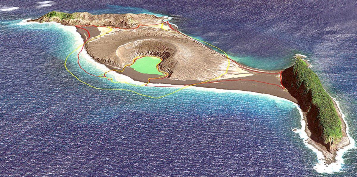
The island is shown below. The cone formed in an eruption in 2015, which filled in the hole between the two parts. It is now gone. The two parts, the two islands that existed before 2015, are called Hunga-Ha’apai and Hunga Tonga. They are ridges a little over 100 meter high and 1.5 kilometers long, with vegetation.

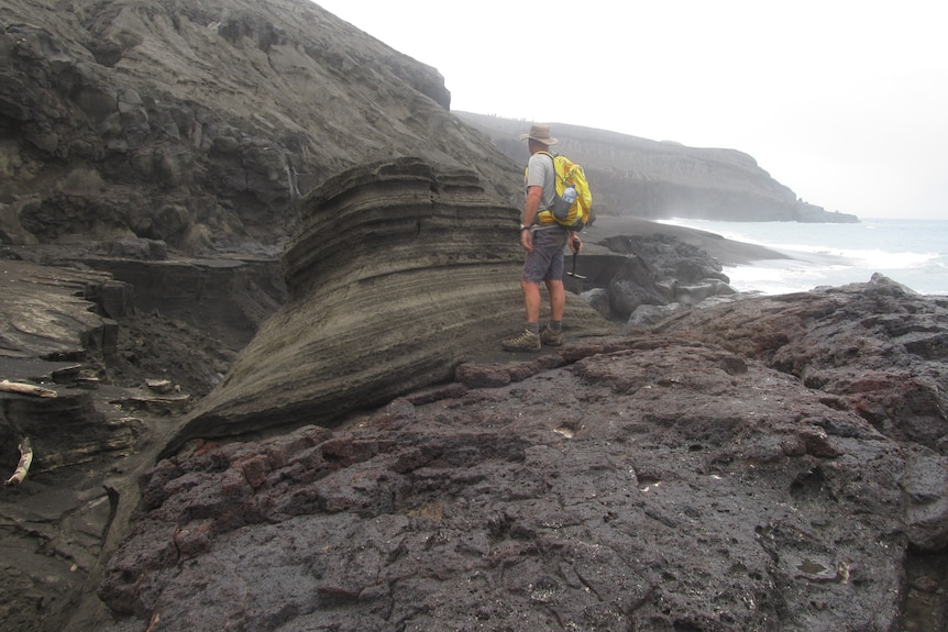
Shane Cronin studied the island after the 2015 eruption. The photo above is from him (taken from https://www.abc.net.au/news/2022-01-16/tonga-volcano-could-erupt-again-says-expert-who-visited-the-site/100759390). It shows the rough eroded side of the ridge, but also a block with thin layers, which originally would have been horizontal before the block fell down. This looks like deposits from pyroclastic flows or base flows. This volcano has done big explosions before.
The map shows two further, very small islands south of Hunga Tonga. Just like the two ends of Hunga Tonga, they show a ridge-like appearance. It is tempting to draw a circle connecting the three ridges, perhaps a remnant of an old crater, 3 kilometers in diameter. Bathymetry done after the 2015 eruption by Shane Cronin confirms the general idea: it shows a deep hole within this ring, partly filled in by the 2015 cone.

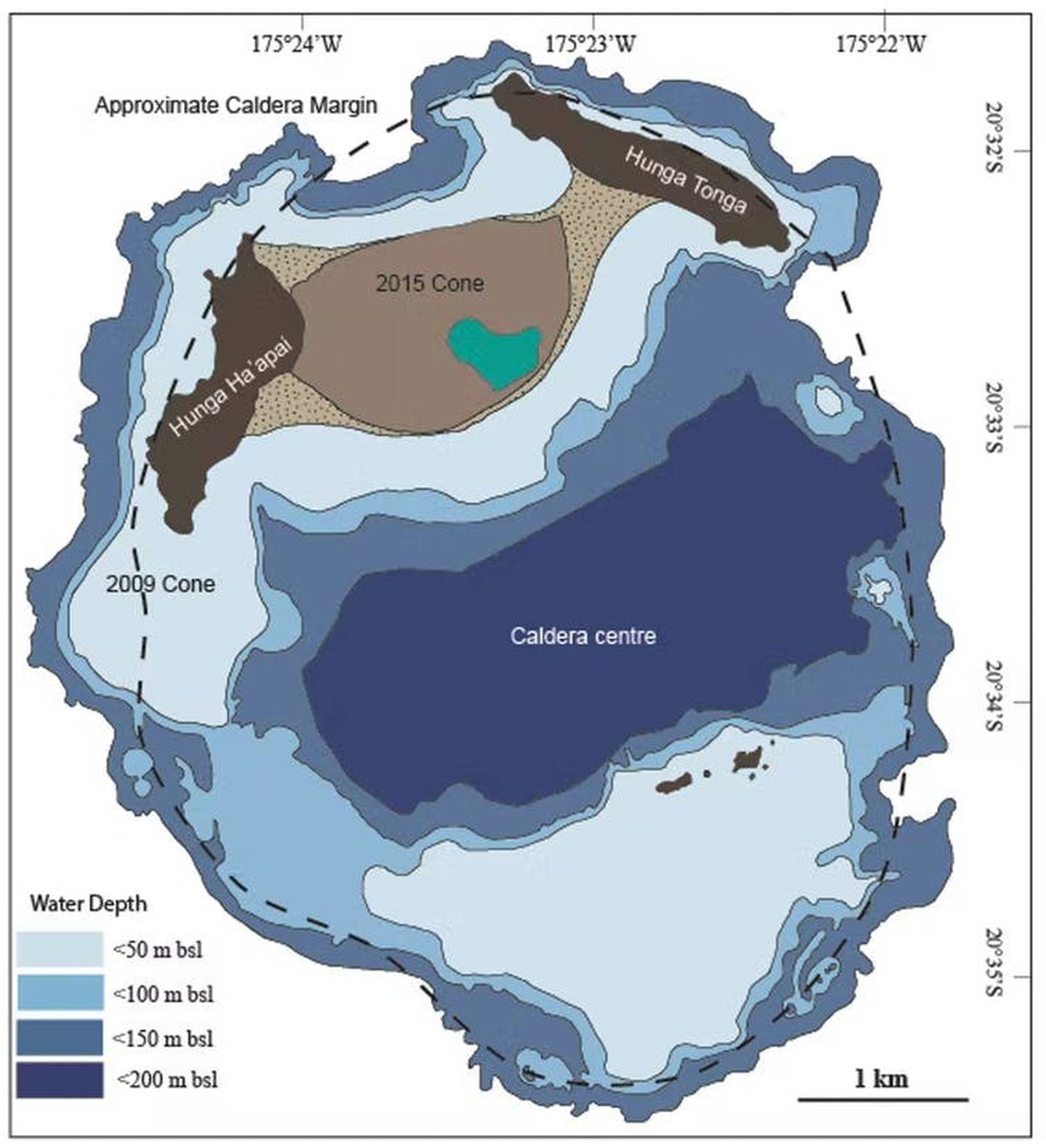
The small islands are seen to be the inner edge of a more extended plateau. The authors interpret this as a caldera with a size given by the outer edge of the plateau. (It had already been suggested to be a caldera in 1972, but this study confirmed it.) I would have taken the inner edge as the size, and go for the smaller caldera; the outer edge is the erosion of the submarine mountain which might even date to the time of lower sea level. There are two underwater domes on the eastern part of the ring which fit this smaller ring. But this doesn’t change the basic idea: this is a volcano which went caldera, and the eruptions are now on the ring fault. The 2009 and 1988 eruption were on the western part of the ring, and the islets on the southern ring erupted in 1912 and 1937.

Source: Cronin, https://eos.org/science-updates/new-volcanic-island-unveils-explosive-past
How big is the volcano? It rises from the sea floor almost 2 kilometers down, and it 20 kilometers wide (from the article by Shane Cronin). There are echoes of Iwo jima here. There is a kraken here.
How old is it? The islands were ‘discovered’ in 1616 when the first Europeans visited them. Locals, of course, knew of them as the ‘shaking islands’, suggesting frequent earthquakes. Carbon dating of deposits show that a large eruption happened sometime between 1000 and 1200. This eruption may also be the origin of deposits on other islands in the archipelago. Whether this was the eruption that formed the caldera is not known. More likely is perhaps that the ring is older, but that large eruptions similar to Jan 15 continue to happen inside the old caldera whenever water comes in touch with magma. Cronin finds that this happens about once per millennium. This makes yesterday’s event a millennium eruption, both because it is the largest volcanic explosion in this millennium so far and because it does this once per thousand years.
The trench

Tonga is well known for its shaking. It regularly features on earthquake maps. A look at the map shows, from right to left, the deep Pacific plate, the subduction trench, Tonga just beyond this trench, and a line of volcanoes 50 kilometers further, forming a volcanic arc. The trench is called the Tonga trench. It runs all the way to New Zealand where it is called the Kermadec trench. The wide ridge on which Tonga lies is pushed up by the subducting Pacific plate. There are frequent earthquakes when the connection gives way. The volcanic arc is a bit further, where the subducting plate becomes deep enough to generate some melt. The molten rock percolates up. This offset between larger islands and volcanic mounts is common, also seen in Fukutuko-Oka-No-Ba eruption
This part of the trench is particularly active, and there are many submarine volcanoes. Hunga Tonga is far from alone. Other islands in this arc are Fonuafo’ou, Tofua (with a large caldera), the steep kilometer-tall, steep cone of Kao, and the non-paradise Late (pronounced la-tay) island.
The eruption
The current eruption cycle began on 20 December 2021 with a significant explosion. The eruption continued for another week, but the ejecta now added to the island rather than destroying it. The surface area increased. The activity continued at low level, with steam clouds but no ash. But it resumed on January 14 with a large explosion. We don’t know how large it was, but ash reached 20 kilometers high, suggesting VEI 4.
The Planet images (https://twitter.com/tanyaofmars/status/1482426851226230784) show the changes over this time, from before the eruption (November), the steam cloud of 7January, to the aftermath of the Jan 14 explosion 2 hours before it blew up completely. Note that the explosion of December was not at the cone but 200 meters northeast, and had destroyed most of the old cone: only the western crater rim survived.

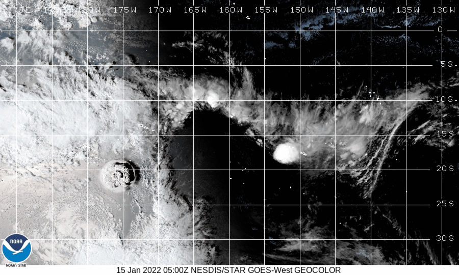
The big event now followed, just before sunset on January 15 (4:15 UT). There were two (perhaps three) explosions in quick succession. The cloud now reached 30 kilometers and stones fell down on Tonga, 60 kilometers away. There are spectacular images available which I won’t repeat here. Instead, the less impressive but more illustrative weather satellite below shows the rapid dust cloud, surrounded by a pressure wave. The pressure (wind) wave traveled at 200 km/h.
The explosion caused a blackout at Tonga, perhaps because of ash interfering with the generators. The islands of the archipelago are reportedly covered in ash, perhaps a few centimeters deep, looking like a lunar landscape. There was a tsunami which damaged the low lying islands – how much damage there is is not known yet as of time of writing, as communications are still down. The tsunami was not high, perhaps 1 meter, but that can still be destructive. Surprisingly, the tsunami traveled across the Pacific, still at 1 meter when reaching Japan, and perhaps half that in North America. It caused minor flooding and shore damage. More seriously, two people died in Peru when they were overtaken by the wave.
Source: wikipedia
The tsunami has done local damage. This https://twitter.com/DrAndreasS/status/1482500248702533634“>image shows how two islands or Tonga have disappeared. This group of 6 islands (four of which are shown) lies about 50 km east of Hunga Tonga. Tau is about 200 meters in size, Nuku about 500 meters. This makes one wonder about the direction of the tsunami. Area to the south and west were less affected, areas north and east much more, extending all the way to Peru. The tsunami waves were mainly directed north and east, luckily away from the populated areas of Tonga and Fiji.

Sentinel radar images taken yesterday show only the two ridges of the original island. The ridge of Hunga-Ha’apai has survived, although its northernmost tip is gone. But only a small central fragment of ridge of Hunga Tonga remains. Everything else is gone, destroyed either by the explosion or by the tsunami that followed. A large raft of debris (pumice) is drifting to the south. The two islands on the southern caldera rim may also have gone. There is some real estate of the world that will be never be seen again. Note that the west island survived much better than the east island, even the easter ridge was taller and had obviously an older large eruption. Wqs this because of the off-centre eruption, or because of the tsunami? Did this ridge direct the tsunami away from Tonga, and so prevented a catastrophe?

Aftermath
How large was the eruption? This is normally classified on the VEI scale. It measures tephra volume, and is designed only for explosive eruptions. The tephra forms by fragmenting the rock. It is much less dense than the rock and therefore larger: the tephra volume does not fit in the hole it came from. VEI-4 is between 0.1 and 1km3, VEI-5 from 1 to 10 km3 and VEI-6 from 10 to 100 km3. VEI-6 eruptions happen a few times per century. VEI-7’s are more rare, about once every 300 years. VEI-6 eruptions have a small impact on global climate, lasting 1 to a few years.
The height of the plume is a rough indicator of the eruption size. VEI-5 can have plumes 10-25 kilometers tall, and VEI-6 goes higher. But the plume height can be affected by many things and is only a rough indicator. At face value, it would put the Jan 15 eruption as VEI-6 (just) and the eruption of the previous day as VEI-5. In practice this may overstate the case.
The fact that two slivers survive puts a limit on the size of the eruption. The crater that formed must fit inside these slivers. That gives a diameter of 2 kilometers. Assuming a hole half as deep, the evacuated volume would be 4 km3. That is in dense rock equivalent. The tephra volume would be larger. Assuming the usual factor of 2.2 (which may be an overestimate for this case) gives a tephra volume of 9 km3, or a high-end VEI-5. It is hard to fit a VEI-6 into the hole, unless it is centred further south than the earlier eruptions in which case it cold be marginally higher. On the other hand, our numbers may overestimate the hole a bit.
These numbers suggest this may have been the fifth largest eruption since the start of the 20th century, after Novarupta 1912 (25 km3), Santa Maria in 1902 (15 km3), Pinatubo 1991 (12 km3) and Quizapú in 1932 (9 km3). (Volumes in tephra, estimated at 2.2 times the dense rock of the hole. (Which is called ‘DRE’ for dense rock equivalent.)
The numbers are however subject to change, and in all likelihood we will never have an accurate size of the eruption as almost all the ash will have fallen into the sea. But Hunga Tonga 2022 was likely a large VEI-5.
Marine eruptions
Eruptions like Hunga Tonga are surprisingly easy to miss. This particular volcano happened to be monitored because it was near population, and of course it was seen by satellites. The most recent similar eruption was that of fukutuko-oka-no-ba, but this was smaller. The most recent comparable eruption was a VEI-5 eruption on October 31 1924, at Iriomote jima, a Japanese island 200 kilometers off the coast of Taiwan. This eruption was completely missed – until a long trail of rhyolitic pumice appeared floating along Japan. The pumice has an estimated volume of 1 km3. We don’t know how much larger this eruption was. The volcano that produced it is 200 meters below sea.
An older case that of Graham Island, off Sicily, in August 1831. It produced less ash, but brilliant sunsets across the Atlantic ocean.
The current eruption is large enough to have a minor effect on global temperatures. The size would suggest a cooling of 0.1-0.2C. However, this is strongly dependent on how sulphur there was. We know there was some, based on reported smells (60 kilometers away!), but not how much. However, Hunga Tonga is at the southern edge of the tropics, and the impact may not easily spread the the northern hemisphere. People in the southern hemisphere may get some colourful sunsets though. Teenager, if your mobile phone takes on a funny red shade, don’t ask for a new one. Look up, and see what your phone screen is reflecting. A silver lining.
Albert Zijlstra, January 2022
(For another overview, see https://www.severe-weather.eu/news/tonga-volcano-massive-eruption-explosion-stratosphere-usa-tsunami-shockwave-fa/)


May I remind everyone about the Be Nice rule…
I saw a few comments above that broke that rule, or skirted it closely.
Please do remember it now.
Any more and I will be taking out my broom.
kids
No, he did say broom
And in regards of the VEI-scale.
Seems like we have a 100 percent vote on it sucking, and for an astonishing amount of reasons.
I think the underlying problem is that it is not based as such on physics and tangible numbers. It is mainly based on a few different phenomena that some people “felt” was having something to do with things. Never a good place to start.
I will try to coble together an article on it. It seems like this eruption has made the VEI-scale utterly obsolete.
Great idea.
Look at this Carl:
With indices running from 0 to 8, the VEI associated with an eruption is dependent on how much volcanic material is thrown out, to what height, and how long the eruption lasts.
https://en.wikipedia.org/wiki/Volcanic_Explosivity_Index
and then this:
Die Klassifizierung erfolgt nach der ausgeworfenene Tephra-Menge, nicht nach Höhe der Eruptionssäule. Ausbrüche über längere Zeiträume haben tendenziell niedrigere Eruptionssäulen als Ausbrüche mit kurzen, heftigen Eruptionen.
My translation: The classification is made according to the amount of tephra emitted, not according to the height of the eruption column. Eruptions going on over a longer period of time tend to have lower eruption columns than eruptions which are short and fulminant.
https://de.wikipedia.org/wiki/Vulkanexplosivit%C3%A4tsindex
From the source (might be useful):
“SIZES OF EXPLOSIVE VOLCANIC ERUPTIONS
An imperfect but handy measure of explosive magnitude is the VEI (Newhall and Self, 1982), a broadly logarithmic scale similar to Richter magnitude
for earthquakes and to a more precise but also more data-demanding magnitude scale for volcanic eruptions proposed by Pyle (1995). The main criterion
for estimating VEI is bulk volume of pyroclastic deposits, but other criteria can
be used when the volume is not well known. The VEI scale is shown graphically in Figure 1.
Chris Newhall, Stephen Self:
https://watermark.silverchair.com/572.pdf?token=AQECAHi208BE49Ooan9kkhW_Ercy7Dm3ZL_9Cf3qfKAc485ysgAAApcwggKTBgkqhkiG9w0BBwagggKEMIICgAIBADCCAnkGCSqGSIb3DQEHATAeBglghkgBZQMEAS4wEQQMk_NygrDlW5smrZQmAgEQgIICSoQ3pjok3D1KFLEPgAD8MzftwcD5Hz3yjQT3qR8WPgwMFsLFeDsX4fiPn6-_VdAGJWgvcJffF34lHU4YDRoRDx4h4KYBHNmyGMYKJQjo_qxDPr5x84Suvhle9sipJ-iqySGLfag6mQZ4j1kvp64FdFPkxaQGCwe02WKESNdNaGLma5t9JBthlYrdpKqpkxSeyvcN0pUF0pplZMi01TRa3EUMloWJtt4SwiaimlAyE_Jins-PpN78hS3pgY7M_qoET5N90G2_UvOJhKivuvKbCk7Z1JtuIfB-PDMj5cs1L_iU6oZl7xsrQM4qHpU0OVPX_E5rNqaoaXUmB45T-HZVm-4f2elWKvi_L7La3HFJVuiK85UEZHyywObdOVOHLW4N6sUqt-Kl0A0-Ed_vmm0CdRBffv3E0N38XFZ-u-qWzlOfD2BM7EVoGrK6dIX-JWFhdDGEiweB6TX8JuIGLr2l9N1JHpDlF5KqpoocW-qzR_T99ZQtWrOhl9ZfuF45zZx6ZOwgG52HTGLpR6SqusnyMIQ2RTZU1QGxBUa7PI_ZvK0fI-41KDTGed8JYne4SePbizv1HmZJInWKsiWfWVsuEsKv_tTdm_EAeBYAHUZGau5euNVS49_-wUtpQP2amUCdwIGvcUzVCv-L85KK2OGg3a7ltFCmhtCp4R9_X4uklMNDBP8LL6pEh8unli48owPrGlPdWnW9x6Sk3fTnLa0IR854jvByraJu-fmfQpmFeYZijMTBXM_wMMcZjV4vKRQsmC9wfzxlPYUlzzg
Better use this and then click the PDF.
That long link won’t work.
https://pubs.geoscienceworld.org/gsa/geosphere/article/14/2/572/529016/Anticipating-future-Volcanic-Explosivity-Index-VEI
If we’re looking at replacing VEI I figure there should be two parts to it at least
1) some measure of total volume of volcanic output with the volume of output being on a log scale
2) a measure for the timeframe of the eruption
maybe the time should be on a log scale too
explosive things might generally (I imagine) have timescales of minutes/hours/days
while effusive things would generally have timescales of weeks/months/years/decades
I’d like it to be possible ideally to still fit prehistoric eruptions into the category
– with estimates of some sort based on the rocks found
it’s a welded tuff – it got out to a range of blah km from the volcano – so it must have been explosive but it’s really thick, so it must have lasted for blah days…
dunno – just wild thought really
Most important to me, it must be possible to calculate Joule out of it in every instance.
I think that I will have to bandy this a bit back and forth with Albert and see if we can’t come up with a workable formulation.
Might be that I write a piece on the problems with the VEI so we have a reference frame, and that we after that go about trying to scrounge up a formulation.
megatons of energy per minute?
I know this is somewhat academic, but why try to fit vastly different eruption types into a single scale? why not two scales (at least), one for the more explosive, short duration eruptions and one for the less energetic, longer-term effusive eruptions?
just use the same scale and preprend the letter E for Effusive or the letter E for Explosive (or maybe F and X might be easier to distinguish) 😉
Yes, I think that is right. the thickness of ignimbrite sheets seems to scale with the duration of eruptions. The area covered by ignimbrite sheets seems to scale with eruption rate. The Taupo ignimbrite of ~ 180 CE is quite thin but covers some 20,000 km^2. This is a result of a short but extremely intense eruption. Fall deposits seem to scale in similar ways as well.
Interesting piece of Károly Németh, Shane J. Cronin, who is quoted here numerous times and has done the bathymetry around Hunga Tonga Hunga Ha’apai after 2015, and James D.L. White,
doubting Kuwae (Tongoa) as a culprit for 1452/1453:
https://benthamopen.com/contents/pdf/TOGEOJ/TOGEOJ-1-7.pdf
I don’t think he’s right, but he might have a point, but I think the exact opposite is the case. I don’t think that Kuwae isn’t the culprit of 1452/1453. I just think the 1452/1453 is dramatically overstated and that there might not have been a Samalas or Tambora-style eruption. Maybe it was similar to this one. Local effects might have inflated the SO² number over Antarctica, there are many numerous omissions in the ice cores and others that seem incredibly ridicilous, because it is suspectible to local effects and factors. You have to see it as fossilisation of gasses, but the process of fossilisation isn’t equally distributed over the planet. In that scenario Kuwae could easily be the culprit of 1452/1453, it’s just that people might make 1452/1453 more than it is.
It isn’t that the little ice age started with Kuwae. No volcanoes of similar size, even Tambora-sized or Samlas-sized are known to do that. The climate eventually recovered after a few years, and effects were often regional/local. But some say the little ice age might have intensified because of it, and I respectfully disagree. Little Ice Age was already starting and was about to intensify regardless of the 1452/1453 spike. There might have been a minor cooling for a year (very minor), but i think it is overstated and the effect isn’t really unknown and you can’t attribute decades or centuries long cooling to eruptions of that size.
Maybe 535/536 + 540 was a decade long cooling but it was also the peak of the little ice age before the little ice age, and the cause 535/536 might have been a dead zone or vatnafjoll fissure eruption, while 540 was tropical with maybe also a relatively minor 547 eruption. And Tambora was also in the middle of the little ice age, maybe nearing the end already but was also helped by an earlier eruption which might make it appear longer than it was, but a cold climate in the 1880’s isn’t attributed to Tambora, so you can’t say that the little ice age started with Kuwae, just like Laacher See wasn’t the cause of the YD.
Are you aware that you are criticizing a specialist on the South Pacific here and not only him, but basically also Albert who has written numerous pieces aligning eruptions, archaological evidence and famines?
Are you a genius to just throw away numerous carefully collected signs of evidence of a university geologist and a university astrophysicist and others on the field who do tedious work, sort of puzzling it together?
Tambora with a VEI 8, sitting very close to the equator is the worst example here. Kuwae is only a suspect for spikes in Antarctica and Greenland icecores.
Then you grotesquely underestimate economy in the Middle Ages. It could break down extremely fast. Most of it was local growth and a bit of trade, not delivered by planes or motorized ships. As soon as it broke down the ability to buy wood for heating got lost. Then they got pneumonia/rats+plague/gout/black death/diphtheria/cholera. Some went as far as to leave their children behind or take to cannibalism. And some decapitated their King and Queen in 1789. And, last but not least, others took to blood libel and that is how anti-Semitism probably started. And not only that, but also witch-hunting.
At https://www.rtlnieuws.nl/nieuws/video/video/5281619/natuurgeweld-tonga-vulkaan-tsunami-boot-video-rook-bliksem “Natuurgeweld Tonga vanaf boot gefilmd: gigantische rookpluimen boven zee (Natural disaster Tonga filmed from boat: gigantic plumes of smoke over the sea)”.
These images are probably from last Friday, with a smaller eruption than the one on Saturday, which was the main event. So this was just the appetizer, which was already impressive.
Yes, that footage of the Friday eruption was amazing, a very powerful version of what is called “Surtseyan” style activity. I think that the Saturday afternoon blast would have looked similar……except for being perhaps 100 times bigger. If the big blast had started when they were filming I doubt they would have survived.
It was put here yesterday, I pointed out the “useful” sequence
https://www.youtube.com/watch?v=-kbVc4FtbE0&t=88s
I think it’s about the explosion on the 15th.
Just a quick question, if, say, an eruption produced 10 km3 of submarine PDC deposits and 0.1 km3 of subaerial material, is it VEI-4 or 6? Does material that never actually reaches the atmosphere count towards the volume used to determine the VEI number?
Oh, and just for the record, I’m going with a low-end VEI-5 for now.
One problem with that
The eruption probably isn’t complete
With the exception of small steam explosions I would be surprised if it was not over. Ripping out the lid of a magma reservoir usually tends to be the end of things for a long time.
The scientists in New Zealand who are well versed in this type of volcano are not so convinced
The high proportion of water vspour to to ejects could hint otherwise
That doesn’t mean that there will be another explosion of that magnitude, perhaps large ash columns?
To the best of my knowledge there has not been any Krakatau style eruptions in New Zealand.
Basically every single volcanologist on the planet is currently winging it based on data from Krakatau. And that data gives at hand that it is over.
When you open up the lid of a magma reservoir you have an immediate pressure release, so the pressure is gone. Secondly you get a deep quenching of the top of the magma reservoir, and that produces quite a sturdy lid on things.
What does.krakatau have to.do.with it except for the explosive forces comparison ?
New Zealand is the land based version of that activity that extends South of Tonga
So the caldera of .the taupo volcanic zone are the best comparison and NZ scientists are the most knowledgeable on those and the submarine volcanoes to the north
They are.the ones that study them like scientists in Iceland are the go to for those
One does.not.consult an Iceland scientist on South pacific volcanolgy
So if this scientist is predicting the possibility of the pinatubo level activity
It would be wise to.take note
These systems are like no other
Iber, I think Carl is pointing at the mechanism of eruption from krakatoa (namely break the lid of the magma chamber and let the sea in = big bang) which seems to match reasonably well with HungaTonga’s eruption (and doesn’t matter where the eruption is globally – just depth of vent under the sea)
and if that is the case then the resultant ‘long delay before any further activity’ that was seen at Krakatoa could be expected at Hunga Tonga too
Edward Krakautau was probably an emptying of the magma chamber like Mt mazuma
There really isn’t sufficient suggested material erupted to suggest that is the case here
So the possibility that this is a violent precursor to a series of large eruptions although possibly not of the same explosiveness can’t be ruled out
That is one of the problems with the VEI-scale.
I think that if nothing else, this eruption pretty much killed the VEI-scale.
To begin with it was just a bunch of ad hoc phenomena cobbled together trying to showcase the power released of an explosive eruption. Problem is that it did not connect back to any energy-related unit from physics that is easily calculable, like joule for instance.
Heck, even assigning Megaton values would be better.
As I read the comments above it seems like everyone who mentioned the VEI-scale above agreed upon it being “sucky”.
The most important thing is the civilisations impact
If this explosion had been in the bay of Naples.
The impact on civilisation would be massive
It has badly affected.tonga because of its proximity but Tonga is small.and isolated
So.really these models for.scale are not terribly useful for populations
I would personally say the VEI scale in and for itself is not even beyond rescue. Apart from all the ambiguities, so shall we also count height of the column if we know the tephra volume anyhow, and what if both do not match up to the same VEI? And what is “fresh magma” precisely, as you mention also below as another weak point. What definitely sucks is that there is no direct connection to energy release (and time domain!), yes, and that people still in absence of that equate VEI number to “size of the boom”. See asteroid impacts as mentioned above. A 1km / 20 gigaton TNT equiv. impact in the Atlantic Ocean is “mild” (had to use that, sorry!!) just because only little rock molten/excavated? Surely not.
VEI does not care about intensity: a VEI 6 that takes a week looks very diffrent than a VEI 6 that takes 10 minutes : )
Hatepe Eruption 120 km3
Did around 30 km3 every 2 to 3 minutes!! I wonder how that woud look like.. crazy
It was a VEI 7 but as intense as a pyroclastic VEI 8 and likley are tephra eruptions many many many times faster than that even
For eruption magnitude there is a magnitude scale that is based on the log base 10 of weight of the eruption products in Kg -7. In this scale an eruption that blasts 10^12 Kg of stuff has a magnitude of 5.0 That mass of pyrolcastics at a density of 1000 kg/m^3 takes up a volume of exactly 1 km^3. That is quoted as the dividing line of VEI 4 and VEI 5 in the volume definition of VEI. That still does not account for energy unless one assumes an energy per unit mass. That would surely vary from one eruption to another.
The other problem is that the scale for magnitude does not take into account the rate at which the mass is erupted. If the eruption of Jan 15 had released the mass of material rather steadily over say a couple of days we might have an eruption no more remarkable than Hudson 1991. If instead of a couple of days that mass is erupted in a couple of nanoseconds (pardon my hyperbole) one gets a result more like what we just got.
I wonder if anyone has even worked out the subaerial vs submarine volume for the VEI scale. Also, a lot of material may have made it into the atmosphere but ended up deposited under water. This eruption seems to me to be a super sized surtseyan style event…..sort of like the footage taken by the Tonga Geological Service from the boat the day before, except maybe 100 times bigger.
I do not think that bending the already conked up VEI-scale into working in a submarine environment is even doable, nor a good idea… 🙂
I think this eruption proved that.
In regards of the low SO2 I think the explanation is quite simple.
We need to ponder the totality of what was blown skyward.
First of all we have roughly half a cubic kilometre of water that was flash-steamed into 850km3 of column.
On top of that we need to ponder what rock we are dealing with. How much was fresh material from the magma reservoir, and how much was old rock that was pulverized.
Only the fresh magma would be carrying enough SO2 to even be noticeable. The old rock might be rich in sulphur, but that would be in mineral form that does not easily transform into SO2 when blasted apart.
My guesstimate is that it was only just north of 1km3 of fresh magma that was erupted, and a few km3 of old rock.
If you then rapidly disperse that magma into the 850km3 mushroom then you would end up with low SO2 values.
Now, here is another rub at the VEI-scale. Only fresh magma turned into tephra shall be counted according to the VEI-scale, as such it is a low end VEI-5. But, if we take a bit of leway and go with all of the material boomed skywards, then we end up with a mid sized VEI-5.
I think the latter is the more honest since it follows closer to the figure of the total energy expanded.
Your mileage may vary.
That means the energy source that flashed that 1km3 of water to steam is still mostly intact
One has to assume that the magma emplacement needed for that level of energy must be many 10s of cubic km in size
As for.the SO2
Maybe high levels of.CO2.were.released.in the eruption
Like shaking a soda.bottle?
It is largely intact, but that does not mean that the pent up pressure is intact. That went as soon as the roof of the magma reservoir lofted into the heavens.
For sure a tremendous amount of energy was released
So.perhaps there will be more obvious earthquake.activity before any further eruptions?
Why? Its been slowly heated to a few hundred C over 1000 years, that’s not a huge energy flow. It probably even started (as its now starting) with a rubble-filled wet hole that was heated with sills and dykes until activity caused the lid to be explosively removed (earlier, smaller bang).
Trouble is letting all the energy go in a few milliseconds…..
Bad Mojo = “Trouble is letting all the energy go in a few milliseconds”
Not too sure how difficult ~1000ms would be. The speed of sound in hot water perhaps close to 2000m/s and that sharp crack needs some explaining. I am not up to speed for supercritical nucleated steam but its surely not out of the question that a shock wave, or just lower levels decompressing with more vigour than upper ones, so as to catch them up and generate a sharp essentially simultaneous explosion close to (possibly a few hundred meters above) sea level does not look impossible to me.
OK The pressure wave, presumably well dispersed due distance, is about 30 mins. I have no idea how different frequencies propagate long distances in air, typically I would expect high frequencies to have short ranges, and low ones long ranges.
OK maybe I was being a tad OTT. I give you 30 mins, is that better?
I just meant that you just gave the perfect definition of the phrase Bad Mojo. 🙂
Brillant comment getting to the core of things.
Carl’s c.
I am the first to note that I have “opinions” about the VEI-scale.
It is utterly obsolete and needs replacing as soon as possible.
You are probably right 🙂
I saw somebody suggesting some other criteria here on VC, Tallis or Geolurking, I don’t remember. The location should be important as well, he said, if I remember that right.
Concerning the only weak point in that very decent piece of Albert’s: He gives the diameter of this long word volcano south of Japan which is a similar setting, with a little over 600 metres and the depth with 100 metres.
Crater then “lake” is supposed to have been 1.200 metres deep and the diameter with six miles now which is 9,65 km. Some erosion should have occurred.
So, if I had to base a guess on these numbers I would not end up with 1 km depth. But that might be seen soon if the eruption is over.
Perhaps a clearer definition of “what are we measuring here?” is needed.
Are we measuring explosivity? If so, material ejected/time is very relevant.
Or are we trying to measure how big (not explosive) the eruption was? Time is not as relevant here (volume-related) but don’t call this an explosivity index.
Carl.
I think that pretty well hits the nail on the head. The physics and chemistry looks good and (pains me to say) I cannot see any flaw in the argument fitting the facts, rather the reverse.
I still thing a two-valued figure for eruptions is a better way to characterise them, total volume and maximum (for some value of maximum) power.
Regarding the explosion-induced tsunami-like waves:
Is it known how they are created? Obviously, the initial “boom” creates large waves locally, but that energy is hardly not coupling strognly enough into the water for tsunami-scale waves.
Then there is the removal of a few (<10 ?) km^3 of water and material from the crater, and the water rushing into that void; that has a bit more potential but maybe not that much, as that is quite close to the surface, so you'd expect the total displacement to be just that, <10 km^3, not enough to create meter-scale waves 5000km away.
What else is there? I am somehow drawn towards the local reduction of air pressure under the rising column, which might be enough to accelerate water towards the crater for long enough to transfer a lot of energy, and the collapsing column afterwards doing the reverse, maybe? After all, to optimally couple to a tsunami wave mode, you need an excitation event on the order of tens of minutes long, instant events like explosions are (thankfully) not efficient.
How about displacement of the sea floor?
So.factor.in the atmospheric energy release in the explosion, and then the approaching magnitude 9 earthquake level release.to.cause the pacific wide tsunami
Those factors.combined make.this super eruption level energy event minus the ejecta
The energy is not the problem, that is precisely the point. There was enough energy in that thing to make Tonga-annihilating waves. But the vast majority of that energy did thankfully not couple into waves, but rather went into the air.
Seafloor deformation, that could do it, but in which way did it deform? That is kind of what I wonder. Even if you were to lift the enitre seafloor of 1000km^2 by three meters for one second and then drop it again, that would not creat a tsunami.
The 2011.japan 9.0 magnitude quake thrust up the sea floor by 10 meters
But of course over 150km by 300km area ,so much larger
But the wave size was very close to the amount of up lift
Remember and earthquake is deep in the crust
So imagine a 20 km by 30 km area of sea floor suddenly rising or deformity by 1 meter
What would that do?
What caused the deformation?
Same source that triggered the explosion?
There where Earthquakes before the Big blast, coud be a ringfault that allowed endless ammounts of seawater to cascade into the chamber
But I coud be wrong with this theory.
It coud also be the eruption vent itself that allowed the ocean to flood into the magma chamber causing a ”Mega Surtseyan” blast
If you where 20 kilometers away from ground zero.. woud the eruption kill?
Very powerful steam pheratic detonation it was
I see. So if this was earhtquacke-driven (the wave, that is), then of course a lot is possible. I was under the impression that there was not a lot of tectonic motion going on though?
On your second point – yes, but if the volume overall is just a few km^3 and only a km^3 of water was evaoprated, then that is not enough volume (as it is all quite close to the surface, most of the action happened on top of that small shelf)
There was earthquakes, but not enough to produce a tsunami.
The ringfaulting earthquakes Jesper is talking about is what opened up the chamber as such, but is not part of what formed the tsunami.
I see, thanks.
Interesting description of the eruption as a ultra – Surtseyan blast. I think that this eruption might have been very much just that. I think that those geologist on that boat would not have survived if the big blast had happened then. I would not be surprised if a base surge rolled out 20-30 km in all directions during that blast. Fortunately, except for Hunga – Tonga itself there were no other islands that close.
I would guess this a combination of .heat ,gas and water by chance going super critical
Creating the perfect conditions for the large explosion that resulted
A freak occurrence
Now the water was always present, so 2.other factors had to come into the equation
Heat and gas and of course that is magma so a massive movement in the magma of the caldera must have occurred over a large area
The tsunami is caused by one or more of the following: (1) the instant creation of a big hole: water rushes in starts the wave (so it begins with a withdrawal of water at the coast), (2) a lot of material suddenly falling into the water, which can be a flank collapse (Anak Krakatau 2018, which is now known not to be related to any eruption) or collapse of the eruption column (This gives a positive wave at the start of the tsunami), (3) a pressure wave from either the explosion or from a pyroclastic flow reaching the water.
Those things explains the pacific wide tsunami
Something really unusual happened there
Yes, those were what I was looking at, so my thoughts are:
(1) Not enough volume of material was removed from the “hole” for this, in my crude estimate
(2) There was not enough material above the waterline for this, but it could have been an undersea flank collapse displacing many km^3 of rock, I agree. If the explosion caused such a collapse, I’m in. I guess that would create a somewhat directed tsunami wave. I suppose bathymetry will give the answer to this one in a few months.
(3) Well, that is the interesting one. I think a “point source explosion” at or above the surface is very lousy at coupling into tsunami wave modes, because those are too low in frequency. A “normal” atmospheric shock wave does not transfer enough energy into a given tsunami mode either, because of the velocity mismatch. Hence the speculation about some secondary effect, creating a large-scale, slow motion pressure variation at the surface, which would couple well to the wave.
I guess I am wondering what is known about these processes. They don’t occur that much, thankfully 🙂
I’m a big fan of the temporary cavity in the ocean to explain some of the volcanic tsunamis.
I see them created by the pressure of whatever is coming up into the atmosphere, as soon as the pressure gets lower than the hydrostatic pressure, it closes.
I think it is gravity that provides some of the energy for the waves.
Personal theory!
This complicates the neoVEI, energy relationship
Yes, but my point is that I think this energy is not enough, because the cavity in the ocean likely was not particularly large. Just a few km across and maybe a few 100 m deep. If you expand that to 10000km Ocean, then that energy is not that gigantic.
No casualties on main island:
Labour MP Jenny Salesa, who is Tongan, last night joined a Zoom meeting with Tongan Methodist ministers, including Rev ‘Ulufonua from Ha’apai.
He told them there had been no casualties on the group’s main island. There was is a lot of ash on the ground and quite a number of houses had been damaged.
“One of the main things that they’re dealing with right now is the damage to the water system and the fact that not all of the people were able to protect some of the tank water that they collect from the rain,” she told Morning Report.
“There are 169 islands in all of Tonga, 36 of those are inhabited, and so we don’t have updates from any of those other islands.”
https://www.rnz.co.nz/news/national/459667/tonga-eruption-nz-air-force-plane-leaves-for-reconnaissance-flight-to-assess-damage
Except https://www.bbc.com/news/uk-60027913
I sadly do not think she will be the only one.
Especially since Tonga was not the hardest hit of the islands.
A couple of people got swept out to sea in Northern California from that tsunami, but they were rescued. At least two out of four were. Currents near San Francisco are very dangerous on a normal day (tides plus narrow bay inlet, why nobody could swim away from Alcatraz).
Have communications with Tonga been restored yet?
This reminds me of what happens after a very bad hurricane: no news from the worst-hit areas.
It turns out that Twitter has some useful items after all.
Found Professor Simon Carns feed.
Lot’s of useful stuff there, especially the number for the SO2 given at 0.4 Tg of SO2 in the cloud.
https://twitter.com/simoncarn?ref_src=twsrc%5Etfw%7Ctwcamp%5Etweetembed%7Ctwterm%5E1482612959104974848%7Ctwgr%5E%7Ctwcon%5Es1_&ref_url=https%3A%2F%2Fwww.bbc.com%2Fnews%2Fscience-environment-60019423
Tg is fairly useless as a scale… We are talking about 400 000 tons of SO2 that was released.
Pinatubo was 15 million tons just for reference.
Couldn’t place that number into any scale, so dug out this:
“Carn and his team found that volcanoes collectively emit 20 to 25 million tons of sulfur dioxide (SO2) into the atmosphere each year.”
https://earthobservatory.nasa.gov/images/89813/satellite-catalogs-volcanic-sulfur-emissions
How much of that is injected into the stratosphere, though? I’d wager a low % of that total, no?
Concerning their online-connection:
“Samiuela Fonua, who chairs the board at Tonga Cable Ltd. which owns the single cable that connects Tonga to the outside world via Fiji, said the cable appeared to have been severed about 10 to 15 minutes after the eruption. He said the cable lies atop and within coral reef, which can be sharp.
Fonua said a ship would need to pull up the cable to assess the damage and then crews would need to fix it. A single break might take a week to repair, he said, while multiple breaks could take up to three weeks. He added that it was unclear yet when it would be safe for a ship to venture near the undersea volcano to undertake the work.”
https://time.com/6139755/tonga-volcanic-eruption/
If part of that cable was atop the coral reef it would have been exposed to currents of several knots or greater. That would be like on the bed of a white water river. No wonder it broke.
Definitely another disturbance in barometric pressure here in Chios, Greece this morning local time. Seems close to 2 HPa. The first one was ~2,7 HPa. The station is at 23 m. above sealevel.
http://penteli.meteo.gr/stations/chios/
I have seen four waves pass Manchester so far. The most recent one was at 2pm today
Please keep us informed of the number of waves.
I’ve seen three so far at my weather station (central Indiana). Interestingly, I only saw the first pass of the first-to-arrive NE-ward propagating wave, but two passes of the “wrap-around” SW-ward propagating one, both of which were very obvious. Below are links to my Twitter posts about each of these.
First pass of first-to-arrive wave (~1430 UTC on the 15th): https://twitter.com/Meteodan/status/1482422824937697287?s=20
First pass of “wraparound” wave (~0600 UTC on the 16th): https://twitter.com/Meteodan/status/1482725641040637952?s=20
Second pass of “wraparound” (~1810 UTC on the 17th):
https://twitter.com/Meteodan/status/1483168101583757316?s=20
Are there weather stations closer to the antipode (in Algeria, I believe)? How much were the pressure waves focussed when they arrived at the antipode? Maybe the detonation was even audible when the wave arrived there?
Good question. There will be many. How many are public I do not know. Try https://weathermap.netatmo.com to start. I found one in Morocco which shows the spike today very nicely.
Earth’s circumference is roughly 40.000 km. Our station is apx. 17.100 km away from the Volcano (Google Earth). So we’re not at the antipode. But not too far off. The joint borderarea of Algerie, Niger and Mali shold be the closest opposite point to the volcano. Any barometric stations there? 😉 I will keep an eye out for more disturbances.
Probably the most useless piece of information you might come across today, but the distance from my sofa to the center of the caldera as per Google Earth is 17 166 km 385 m. and 62 cm. 😀
That should be enough for a tsunami-warning for the Manchester Ship Canal.
Everyone is just bashing the VEI scale! Come on guys, let’s show it some love…the scale does it’s job well enough. VEI 3-8 are major eruptions. Any volcanalogist or volcano- enthusiast knows how intensity and duration can affect the nature of the eruption. The scale isn’t for energy, duration, or intensity; it’s for size and it does that job nicely.
The “Enhanced” Fujita scale and Saffir-simpson have similar issues, these scales don’t factor in forward speed, size, radius of maximum winds, and other things that have a major impact on the nature of some events. We just need to give context i.e slow moving large Cat 1 hurricane or a Fast moving narrow EF5 tornado. This eruption was an extremely violent VEI 5.
I would argue that we do not understand it, and the question about duration and intensity caused a fair bit of friction up above.
Even from the standpoint as a geophysicist I do not understand it and how it is used since pretty much everyone uses their own interpretation of how it should be interpreted.
Also, I hate any scale that is not easily calculable back into a common denominator energy standard unit.
I’m inclined to disagree, from what I can see the debate is on what actually caused the violent explosion, not on how violent it was. Anyone with eyes can see this was an extreme eruption but do we have to factor in the cause of the explosion in its ranking on the VEI scale?
Everyone has their own interpretation on a lot of things and with so many other variables being left out of the scale, people are going to neglect what the scale is for. which is size. A single eruption that produces 10 km3 over 10 days is bigger than an eruption that produces 1 cubic in 10 seconds but the latter is clearly more impressive.
Agreed. The mechanism (cause) is more important.
Right on here. Biggish eruption, stupendous eruption rate.
I have no scientific knowledge at all but it appears to me that the problem is they very name of that VEI scale. Am I correct that the name is volcanic *explosivity* scale? For me I am totally out of my depth when even an efusive eruption can be assigned a VEI number when there is very little in the way of apparent explosivity. Yes I am just a simple woman and like simple explanations. That eruption is the biggest *EXPLOSION* I have ever seen in my life. I am 72 and have seen plenty of documented explosions of atomic bombs. Obviously nothing I have seen before has even come close to rivaling this eruption in explosivity, (even Mount St Helens which was breathtaking), so why would it not have a high explosivity scale?
I think whatever happens in the future measuring eruptions using explosivity surely cannot be an accurate guide and in my view VEI scale is a misnomer.
Now please all shoot me down in flames. I will not be offended, I just like to understand things in simple language.
Misnomer is not bad.
VEI is volcanic explosivity index, in fact.
But it’s not that simple to use it properly.
As you noticed, there is no point assigning a VEI to Fagradalsfjall for instance, since it isn’t really explosive.
So, just from feeling it is a high VEI because it was so fast erupting.
But it didn’t threw enough rock or magma to have officially a high VEI.
Since officially, VEI is only about the eruption volume, no matter how long it takes to erupt that amount…
Apologies, by “it didn’t” I was referring to Hunga Tonga Bonga Wonga Ha’aa’paa’iii, or so. XD
One more thing, I don’t know whether VEI will be deprecated soon. But yes, using it clearly may give some major issues.
Not sure if it is fair to say that volcanoes are more similar to earthquakes then to hurricanes, but Earthquakes have both a magnitude scale as well as a shake intensity scale.
The thing is. If I am being told that something happened to a island. I know what to expect when they tell me its hit by a cat 1 or 5 hurricane. I know how how much damage a EF1 or EF5 tornado can cause.
And if they tell me its been hit by a Magnitude 1 or 9 earthquake. I can guess how much or what is still standing.
With the VEI scale. If they tell me there is a VEI 5 eruption. I don’t know if it has one of those quint little tourists eruptions that just went on for a few decades and the islanders are now happily BBQ over the lava.. Or if the entire Island blew itself to smithereens.
New article in “Stuff” (NZ) just now with new statements from Professor Shane Cronin, a vulcanologist at the University of Auckland, and Niwa hydrodynamics scientist Dr Emily Lane on theories on the eruption and the tsunami. A lot of what has been proposed here on VC, but still an interresting read.
https://www.stuff.co.nz/national/explained/127518270/the-most-explosive-eruption-in-30-years-hunga-tongahunga-haapai-rewrites-tsunami-rules
Most of what I have been saying
The energy released.is similar to and earthquake of over 8.5 mag for the purpose of the tsunami effect
How many Megatron is that
USGS: “The U.S. Geological Survey estimated the eruption caused the equivalent of a magnitude 5.8 earthquake. Scientists said tsunamis generated by volcanoes rather than earthquakes are relatively rare.”
From the link to Time Magazine I placed a little further up.
“The magnitude of this event is calculated using techniques calibrated for earthquakes. The current magnitude is only a preliminary estimate for this volcanic event.”
I think part of the reason for that is very sparse information on ground from within Tonga due to communications beeing mostly down throughout Tonga. 7 reports is like almost none.
I think it will be revised, but we’ll see.
https://earthquake.usgs.gov/earthquakes/eventpage/us7000gc8r/executive
For this long stream on VEI, “All measures are wrong, but some measures are useful” seems an appropriate re-phrasing of a famous quote!
“All models are wrong, but some models are useful” George Box, a well known statistician
Queensland had a nice sunrise
Wow! Then imagine Tambora or Toba skies 🙂
My absolute favorite is this one from 2012:
https://epod.usra.edu/.a/6a0105371bb32c970b015438c5312a970c-pi
It’s worth getting up early in Australia especially when tropical cyclones hang around. The net is full of them. Unfortunately most belong to flickr or Alamy.
Wow and natural colors too?
Tropics are humid and lots of ice crystals and humidity high up in the atmosphere causes the lovely tropical colors
Wow thanks for that photo Denaliwatch. Superb! Now have a new desktop background.
Ding!
To use a single metric (a pseudo VEI) that combines volume and power is pert-near useless.
IMHO, VEI should be split into separate scales that expresses either energy or volume as two independant metrics.
If VEI was to become based on total energy released and peak energy released, and erupted new magma used to measure volume via a Total Volume Erupted scale, I think comparisons between volcanic events would be much more meaningful.
We already pretty much know TVE, but the “power” is where the hangup is.
To that end, I propose that we now have a new factor that can be considered as an indicator of “power”…which is the much ballyhooed pressure wave…which we have been able to observe for the first time in high detail both visually and via precision instrumentation around the world.
Given there have probably been 10,000’s of reliable readings of barometric pressure changes caused by the Tonga eruption that were made across the planet at various altitudes and distances (all thanks to both commercial and private weather stations), I’m sure there is a way calculate how much energy (explosivity) was needed in order to propel a pressure wave of a given amplitude (barometric pressure) to a given distance and speed. The same idea is common to the eruptive plume height metric where ejecta propulsion/acceleration is used to estimate power, but as we now know, plume height is not really the best indicator since it’s fraught with other influences such as water content, ambient atmospheric conditions, magma temperature, ash size, etc.
So, I propose that a better metric for determining VEI would be to measure the amplitude and speed of a resultant pressure wave…(assuming one was even produced). The only drawback is a pressure wave metric would likely not be useful for effusive eruptions like Frag or Kilauea…but that’s where the TVE becomes the tool of choice to make relative comparisons between eruptions.
Based on previous meteorological data following major eruptions, observed atmospheric pressure waves can circle the earth several/many times before fading out, yet explosions only the size of a couple of sticks of dynamite can produce shockwaves that would be measurable (over admittedly shorter distances). Hence, pressure wave data could be applied to virtually any explosive eruption.
251.04 PJ to be exact. 🙂
Well, measuring atmospheric pressure waves is practically what has been done for human-made explosions for close to a century or so. However, becomes harder for much slower eruptions…
Correct. A slower eruption would be less explosive by definition.
Good idea, but we need not just the peak, but a (short) time element too. This perhaps measured over somewhere between 1 hr and 1 min? The energy is in the area and volcanoes (by their very size) tend not to do ultrashort ultra powerful but can do short and powerful. Even nuclear bomb blasts are ~60 secs long on the ground.
One death reported on Tonga https://www.bbc.com/news/uk-60027913
Too bad. This makes it equal to La Palma. There it was a fire fighter. Fire and water.
So looking at this eruption and comparing it to the hypothetical about Iwo Jima in: https://www.volcanocafe.org/the-new-decade-volcano-program-no-1-ioto-japan/ there is good news and bad. Bad news is is Hunga Tonga proved sea volcanos can produce respectable tsunamis. Albert estimated a volume of 4km^3. Iwo Jima has added roughly 15km^3 of bulge since last eruption assuming the caldera was an even 200 meters below sea level after last explosion and gained 100 meters at the edges (based on Suribachi’s rate of increase on the rim and actual depth of ~100m) and 360 meters at Motoyama. So only 4 times as big as Hunga Tonga at max.
Outside of Tonga where we have little data outside the capital, highest tsunami was 2.5 m in Vanuatu 1800km away. That suggests Iwo Jima might be able to produce 4-10 meter tsunamis on the Chinese and Philippine coasts. A little higher for Japan. 2-4 m tsunamis all around the pacific.
So good news, is while that is pretty bad, it is not as bad as the article’s suggestion of 20+ meters in China and 40 in Japan. Difference is probably because New Decade Program suggested a VEI 7, but doubt Iwo Jima is capable of more than mid-range VEI6 right now (though of course the longer the roof takes to fail, the worse it will be when it does).
Iwo Jima maybe capable of a big fast VEI 6, all the WW2 artifacts and buried human remains blown too towards Saturn …
And here is a 150 kilometers wide submarine caldera, If the apolaki really is a volcanic caldera, its made of volcanic materials, must have been a truley develish eruption behind that one, deserves a VC article on it, But lack of geological survey of that area, If it is a caldera its one of the largest in the solar system
https://en.m.wikipedia.org/wiki/Apolaki_Caldera
I’m not totally persuaded Apolaki is caldera rather than a volcano field that is roughly circular. If it was a caldera it would cover 15,000 km^2 or about 10 times the size of Toba. It is 3-4 km deep. That would be a VEI 10 eruption! I would think we would be aware if there was a missing explosive eruption dozens of times bigger than Toba even if it took place millions of years ago
Incidentally, I think I know the reason the tsunami was so unimpressive in the Tongan capital and Fiji compared to places much further away. They are surrounded by coral barrier reefs on which the tsunami would have broken first before it reached the islands proper. Vanuatu lacks these reefs and so got the full force. Vanuatu is twice as far away from Hunga Tonga as Fiji, but it had a worse tsunami. That can’t be directional bias in the force of the tsunami because Fiji is basically directly in the line from Hunga Tonga to Vantuatu.
Glenn Rivers whats most intense pyroclastic eruption in eruption rate In known geological history? Hatepe did 30 km3 every 2 to 3 minutes 🙂 basicaly blowing the volcano towards Saturn.. 🙂
Previous large pyroclastic eruptions from Taupo coud cover almost the entire North Island in igmigbrites
As far as I know that is the insane María Técun Tuff. 3700km3 of welded tuff in one go.
Lurking is walking on top of 30cm of the MTT, that is how far it went.
So this is Lake Atitlán, formed 14-11 Ma?
The current lake Atitlán formed later.
The MTT event was the first of 3 caldera forming events at roughly the same location.
The first was VEI-8, the second a VEI-6 and the third a respectable VEI-7.
It may also rank in as one of the most beautiful places on earth. It is just ridiculously pretty. We had our honeymoon there.
Thanks, found it, good read:
Guatemala has several large volcanic complexes and the second largest is the Amatitlán Caldera. Only the Atitlán Caldera is larger, both in size and in maximum eruption size, to date Atitlán is the only VEI-8 volcano in Guatemala (Maria Tecún Tuff).
https://www.volcanocafe.org/the-new-decade-volcano-program-the-missing-volcano/
This is really something that needs thorough monitoring, more than anything, similar in Nicaragua:
“If the amount of fresh magma is larger than the old stale magma there will not be time for a dome extrusion, you just get very rapid inflation and then that part of the caldera goes off.
This type of eruptions would produce a pyroclastic base surge covering everything fifty kilometers out to a depth between 1 and 20 meters. Currently there is not enough monitoring equipment in place to detect an upcoming eruption of this type, and due to the high population ratio contra routes of evacuation it is dubious if it would even be possible to get the population of Guatemala City evacuated. And, as monstrously as it sounds, even if you could evacuate the population there is no realistic place to evacuate 6 million people to. If an eruption like this occurs between 1 and 3 million people would die.”
Shocking.
Sadly I can’t do year around monitoring of Atitlán, but I do have GPS-fix points around, so my plan was to do yearly or biannual checks. The cameth The Pestilence… 🙁
Amatitlán is easier for me to permanently cover since wifes house is on the caldera rim and I can stick equipment into it.
Replying to Denaliwatch about Guatemala City. The city itself is built in a dreadful place! Extremely dangerous in a large scale quake as well as extremely risky if the volcano should go off big-time. I would rather be in Siberia personally!
But then I am a professional coward.
Yeah, I love Guate in general. But they really do not get the importance of placing their capitals in the right place.
It is the fourth incarnation, and everyone has been progressively worse in terms of geological safety.
Weirdly enough, Antigua (the previous capital), is much safer… in all ways.
If you visit Guate you should probably go straight from the airport to Antigua. Guate city is uggly and unsafe for tourists, and Antigua is beautiful and quite safe for tourists.
There is La Garita 5500 km3 Toba 4000km3 and possible 20 000 km3 prehistoric pyroclastic pyroclastic sheets
How intense was the María Técun Tuff ? Taupos Hatepe barfed at 30km3 every 2 minutes 🙂
Clive Oppenheimer seems to have said to the British Telegraph on March 11th 2015 that the new island between Hunga Tonga and Hunga Ha’apai would soon disappear. Unfortunately I don’t know what else he said as I’m no user. Maybe somebody here is a Telegraph user and can read it. Headline is “New Island in the Pacific Will Soon Disappear”.
If that is the Daily Telepgraph, I can’t comment on the rest of their content, but on science all their numbers require checking.
It would be interesting though to know whether he was speaking of erosion or of the volcano going boom.
Ok. Found somebody who’s logged in there. He said it will probably be washed away, but that would take some time. Then they talk about a Japanese research vessel with scientists who were killed by the eruption of an underwater volcano in the fifties and then about Graham Island which appeared next to Sicily in 1831 and became a dispute between Sicily, France, Spain and – guess – the UK, so it decided to diappear six months later 🙂
That’s all. No prognosis of an eruption at a later time.
I am a user of the telegraph, for which I repent of my sins. I will check for you.
“A new volcanic island in the Pacific will disappear after a few weeks as the sea washes it away.
The first photographs of the new island appeared on Wednesday after three men scaled its black beach and photographed its crater.
They said the surface was still hot and the green lake in the crater smelt strongly of sulphur.
The island is the result of an eruption that began at the end of last year.
An underwater volcano spewed enough ash into the sea that its accumulation resulted in a one-mile long cone appearing on the surface last month, roughly 40 miles from the capital of Tonga.
However, the island is likely to be washed away since it is composed of ash rather than lava.
Clive Oppenheimer, professor of volcanology at the University of Cambridge, said that, given the similarity to neighbouring islands, the new land could survive for several weeks.
“When a volcano erupts in the sea, it’s very explosive, which makes a lot of ash. If it goes on long enough, the later eruptions can be lava rather than ash. And that is when land will form,” he said.
Such islands are useful to volcanologists, he said, because they are relatively rare and difficult to explore. He told how a group of Japanese scientists on a research vessel were killed in the 1950s by getting too close to an underwater volcano.
“There have been quite a few such explosions in Tonga, because it’s part of the Pacific Rim of Fire. What often happens is that they get knocked down by waves before they can form.
“But this has evidently been going on for a while, so is unlikely to disappear overnight,” he added.
In 1831 an island appeared off the coast of Sicily, which was named Graham Island.
It was soon the subject of a four-way dispute between Sicily, Britain, France and Spain.
Fewer than six months later it disappeared into the sea again.
Hawaii’s big island, however, is actually five undersea volcanoes which grew together.
Tonga and Japan have both seen three new volcanic islands since the 1960s.
Niijima, a volcanic island that appeared roughly 600 miles south of Tokyo in 2013 was initially also expected to wash away. However, it has continued to grow and is now 11 times its original size, swallowing up an older volcanic island, Nishinoshima, nearby.”
https://www.telegraph.co.uk/news/worldnews/australiaandthepacific/tongafrenchpolynesia/11465651/New-island-in-the-Pacific-will-soon-disappear.html
It refers to the erosion rate of this type of ‘new land’. It was not actually the island though. The single island had been there for 6 or 7 years, and the two ridges were ancient. The December eruption had doubled the central part in size. That new part would have disappeared very quickly again, as Oppenheimer said. He did not say the whole island would go. The part about a new island was inaccurate in the Telepgraph report. The basics about high erosion of the added land would have been right. But in the end that was destroyed on Jan 14, and almost all the rest went a day later. Making predictions on volcanoes is risky. Even for Oppenheimer.
More for somebody like Oppenheimer.
Thanks, everybody is allowed a few sins 😉
So basically, without having read the current post, I hold that Tonga detonation has been a big basalt blast (BBB).
See Héctor’s nice BBB series, starting right here “https://www.volcanocafe.org/big-basalt-blasts-i-the-trigger/”.
That is really really some astoundingly dangerous sh**. NEVER EVER seen/thought non-silicic volcanoes pulling off such a show!
@Randall, you asked how this is supposed to even work. I think it that series you may get answers, or at least an idea what could have been the reason.
Only question I have, has there been constant deflation/removal of pressure/magma beforehand at Tonga?
Andesite, not basalt is Hunga Bonga Bunga, Hapai Hu ha
Still not really nasty stuff like dacite/rhyolite =)
Try inbetween, basaltic andesite. It is a mafic volcano but a little more evolved. It is a lot like Nishinoshima actually, might have been a similar island before going caldera. On land these would be pretty safe volcanoes but the ocean turns them into real monsters
I wonder just how insane the surfacing of a new Hawaiian volcano could be, it is never really considered much just a brief stage but this could be really insane, basically Hunga Tonga but orders of magnitude more magma 🙂
I do not know. Canary Archipelago had quite some recent activity on the coast off La Restinga / El Hierro in 2011. All went relatively benign. A bit scary of course to place the HTHH-blast in your mind at that place, but reality for sure is that it is a much different situation.
That actually is a different scenario, slow eruption as well as there not being a shallow magma chamber. When the Hawaiian volcanoes surfaced they would at some point have a large magma chamber immediately underwater, and we know today they have rough caldera cycles of a few centuries, a caldera collapse in that situation would be rather similar to what we just saw at Hunga Tonga.
If it can happen at Grimsvotn or Taal there is no real reason it cant happen in Hawaii under the right conditions. None of the Hawaiian volcanoes is in the right conditions now so I am safe 🙂 but Loihi will be soon geologically speaking, and Kilauea was as recently as 10,000 years ago a Taal on steroids for all purposes, Hector probably will explain. The Pahala ash is at least 50 km3 in volume, tens of meters thick even 50 km from Kilauea, the formation was of course not one eruption but many over a 20,000 year period, but there must have been at least a few really big blasts involved at some point.
I think key is that all these big submarine explosions were caldera collapses, normal pressure driven eruptions or lava flowing into the ocean rarely does anything notable. Caldera formation necessarily requires a loss of pressure, which in a wet environment is a very dangerous combination. I think Krakatau has really thrown the whole world off on this, it was silicic so we made the assumption only silicic volcanoes could explode like that and its magma composition was important. But now we just got another similar and maybe an even bigger bang, from a mafic volcano. Seems the only actually important thing is that magma is hot, and the volcano is low pressure from magma drainage.
Let me try whether your link shows up:
https://www.volcanocafe.org/big-basalt-blasts-i-the-trigger/
I think I would call that hypothesis confirmed.
@Jesper: Do you know of any VC article regarding Taupo Hatepe explosion?
Sounds like a not uninteresting eruption, 30 km^3 every few minutes is not that bad…. 😮
Perhaps was rhyolite at 500 °C, pressurized to 999999 GPa before release? =D
Plume must have been catapulted to the edge of space due to that 🙂
Yea.. Hatepe is stuff of insanity really the opening of it must have looked more like a nuclear blast than anything else, just without the heat, the explosion cloud must have engulfed the Northen Island in minutes! It woud be an enormous angry wall of steamy grey cauliflower from horizon to horizon, it too was partly energized by water, with a later dry plinian stage .. woud be ligthing mania
But large VEI 8 s and possible VEI 9 s may totaly dwarf Hatepe in eruption rates too
I am not sure that all VEI 8+ have higher eruption rates than Taupo ~180 CE. The Bishop tuff in California is a VEI 8 and the ignimbrites cover a much smaller area than Taupo……perhaps 1,000 or 2,000 km^2 compared to ~20,000 for Taupo. Simulations of super-eruptions suggest that area covered by ignimbrite scales approximately linearly with eruption rate. The simulations indicate the extent of dilute PDC before liftoff and not the area that might be invaded by slow moving dense fluidized flows that can continue to flow outward with topography independently from the column-collapse generated dilute flows. The simulations suggest that eruption rates of 10^9 kg/s can cover 300-500 km^2 with ignimbrite, 10^10 kg/s can cover 3000-5000 km^2 and 10^11 kg/s 30,000 – 50,000 km^2 and so on.
Here’s a piece:
The Hatepe eruption was the most violent Plinian eruption in the last little while. You probably have to go back 5,000 years to find anything with a bigger bang, although over the last couple of years I have come to doubt the veracity of this claim. Tambora, Krakatoa, Baekdu/Changbaishan were also pretty big eruptions, but possibly they just took a couple of hours to do what Taupo did in a few minutes.
https://volcanocafe.wordpress.com/2012/11/18/tvz-part-ii-taupo-volcano/
It’s from 2012 from a writer named Spica, unknown to me as I wasn’t here. Maybe there’s also a newer piece.
Thank you very much!
Will be my read for dinner =D
No VC articles on it so far .. Im working on my own VC article on a diffrent topic
I know it, this volcano being even, shockingly to me, on the list of BBB volcanoes!!
From Yahoo news
“SYDNEY/WELLINGTON (Reuters) -A distress signal has been detected in an isolated, low-lying group of islands in the Tonga archipelago following Saturday’s massive volcanic eruption and tsunami, the United Nations said, prompting particular concern for its inhabitants.”
Found the islands in the article, one has some buildings, but very little. The other appears uninhabited. I have watched videos of cruisers that have visited the island group.
Mac
https://news.yahoo.com/impact-assessment-aid-efforts-underway-212728101.html?guccounter=1&guce_referrer=aHR0cHM6Ly9kdWNrZHVja2dvLmNvbS8&guce_referrer_sig=AQAAABnsml8bf6ZolcHsbOFmdfoxiSY0wgU8eXMbmy24vGUNwsRWmfv4sDJ5VerFu8t7_RsvREY76YUiyDtZAS2Ncr-2FX63E7sgpEpH15hZZH68h2qkefN0gJ1kB6OXPvzh-wtUm5rpiOSfyvXvN0mG4ZMTdgQZ0IotMpefmhDTgnTC
CO2 and explosive eruptions
Could this explain the relative lower amount of SO2?
https://news.uga.edu/research-finds-link-co2-big-volcano-eruptions/amp/
I don’t see a link with the the SO2 problem.
Lack of SO2 rich magma
Explosion driven with water vapor.and CO2 as main entrapped gas?
Magma is going to have many different types of gas. In a volcano the main gas driving eruption is water, and carbon dioxide is also important. But the sulphur dioxide will always be there too.
Another wave question, this time in air:
If you look at the satellite videos of the blast, such as the one in the article above, you see two distict ring wave fronts in the cloud formations: First, a “negative” one, where clouds briefly disappear and then reappear. Secondly, a second ring which is “positive”, so the cloud density *in*creases briefly as that front passes through. The speed of that second front is about 1/4 to 1/3 that of the first.
The first one is almost certainly “simply” the pressure shock wave of the blast: Because you excpect the clouds to briefly reduce as the front passes due to the increase in temperature from the compression of the air in the front. So that front seems to be initially positive-pressure dominated, as expected. Also, the speed seems to be reasonably close to the expected speed of sound, so all that makes sense.
However, the second wave with about 1/4 the speed of sound, and with a net temperature *de*crease puzzles me. What is that? Some kind of atmospheric gravity wave? But they should be dispersive, so is this some kind of solitonic gravity wave? Has this been observed in this form before? Does anyone have ideas?
Maybe a lower pressure due to the air being forced up by the growing ash column ?
Sure, but if that were just a regular pressure wave, then it should move at the speed of sound, same as the first shock wave. So it is not just negative pressure, but also a different type of front / wave.
Also, the air column likely was rising for quite a long time; many minutes, but the wave front seems quite compact.
I think it was likely a gravity wave of some sort if it was moving much slower than sound. Once the eruptive column reached the stratosphere and encountered the abrupt increase in static stability, it would excite such waves. Gravity waves are routinely generated in this manner from overshooting tops of deep convective storms.
Not sure I understand the physics well enough: what actually happens when, let’s say, a cubic km of overheated water starts to explosively vaporise? Carl mentioned expansion of water by factor 1,700 when transforming into steam. In the process the remaining water should cool down until it reaches 100C, which means the water vapour it is now mixed with goes to 100 C as well. Moving up in the atmosphere the steam would rapidly cool and condense back into water. Would this generate an implosion that causes the negative pressure wave?
The water is under high pressure. The boiling temperature is much higher there. As the pressure drops, the boiling temperature drops below the water temperature and it flashes into vapour.
Yes. A big bubble of overheated water somehow makes contact with a depth where it can vaporise. Then everything should go really quick. The steam will remove the water column above, the pressure will drop, and bang.
If the steam water mix equilibrates at the water boiling point the reverse process might happen quite quick as well.
I don’t think so. The steam can not spontaneously recondense because the energy is there, it has to go somewhere. Yes, it will condense into bigger and bigger droplets, but that process will take a while. I don’t see that there will be some kind of “flash collapse” similar to superheated water flashing into steam.
But even if so – it would still not explain why the negative pressure shockwave travels at a speed far below the speed of sound.
That wasn’t the shock wave. It was the wind behind the shock which travels at a quarter of the speed of the shock.
The sequence should be:
supercritical water under pressure at perhaps 400C.
Lets say its 10% water the rest is rock at 400C.
Pressure drops it flashes to steam BUT this requires latent heat of evaporation (540cal/gm).
This is provided by the hot rock and water (with some to spare).
The column then rises, partly because its fired like a massive mortar shell and partly because its hot (100-200C)?.
It then rises to the stratosphere at 20km where the pressure is about 1/1000th that at sea level (expanding OUTWARDS as well all the time).
Gas laws PV/T=constant and its adiabatic so pV^1.3= constant sooo (sums quickly done offline) that’s 1/10 starting temp (kelvin) for a 1:1000 pressure drop so cold, 40-50K (not counting ash that does not expand and cool).
Which is quite neat, to put figures on what appears to be very cold ascending gas at the bottom of the stratosphere, despite starting of at maybe a few 100C!
Isn’t physics wonderful?
Also explains the 1/2 hr pressure pulse because that’s what it took to reach the stratosphere, expanding rapidly as it went.
So what was a sharp sudden explosion (judged from the crack heard locally) took 1/2 hr to expand to its fullest extent (for the explosive phase).
PS Being dyslexic my quick figs need checking …
I once thought 30 (I use 30 not 20) km is about 10 hPa maybe…
So would be decompression 1:100 instead of 1:1000…?
Other than that, I forget how to calculate adiabatic state changes =D
But 40 to 50 K appears a bit cold to myself, as it would be below Liquid N2^^
Maybe we must not assume adiabatic changes in the first place, since the water vapor condenses and even freezes..?
Re: VEI scale…
As others have noted, the problems are rooted in scale combining power AND volume into a single number, and then using it for multiple purposes. Anything we come up with as a replacement is going to suffer either from the same problem, be too complex for public use, or be too precise (and fragmented, with multiple scales) to be generally useful.
I can think of three common uses of the VEI scale that would benefit from more useful numbers.
1. Volumetric measure – useful to geologists and others comparing raw sizes of current and past eruptions.
2. Emergency preparedness scale (most directly useful in calculating the GTFO distance from the eruption.
3. Somewhat more narrow useage, but the climate impact of an eruption could be quantified as something like Tg of SO2 injected into the stratosphere.
Have I missed anything else substantial the VEI scale has been used for?
No, but why is Tg used instead of t/kt..??
Saw that more than once, just wondering why =D
“At La Palma” I “learned” to measure SO2 emissions in t/ t/day^^
Because chemists tend to enjoy really small scale numbers, and then draw them out into ridiculously large numbers.
I think it is a strange way of overcompensating something completely different.
Albert,
from MACUSN’s link to yahoo:
“The OCHA said there had been no contact from the Ha’apai group of islands and there was “particular concern” about two small low-lying islands – Fonoi and Mango, where an active distress beacon had been detected. According to the Tonga government, 36 people live on Mango and 69 on Fonoi.”
Are these the islands on the south-eastern rim?
If yes, I hope some left by boat in the morning after the first eruption. If they had boats.
No. I don’t know where Fonoi is. Mango is northeast of Tonga https://www.google.co.uk/maps/place/Mango+Island/@-20.3274588,-174.7208931,3088m/data=!3m1!1e3!4m5!3m4!1s0x718cd96bdb0bcc65:0x9bb1ccd4d50bcf8e!8m2!3d-20.3271121!4d-174.7119632?hl=en
Suspect that it is Fonoifua island, which is about 10 km NW of Mango:
https://www.google.co.uk/maps/place/Mango+Island/@-20.2794052,-174.63263,3403m/data=!3m1!1e3!4m5!3m4!1s0x718cd96bdb0bcc65:0x9bb1ccd4d50bcf8e!8m2!3d-20.3271121!4d-174.7119632?hl=en
Fonoi is about 25 km north of Hunga Tonga; Mango is about 75 km ENE.
Oops. I found Fonuafo’ou, which is a submarine volcano. Still looking for Fonoi.
Oh oh……I just realized…..Fonoi might be close enough to Hunga Tonga to have experienced a base surge from the eruption……A pyroclastic surge. I did not realize that people lived there….I can’t even see any land there on Google Earth. I sure hope that did not happen.
Ha’apai group further north: see map
https://www.researchgate.net/figure/Map-of-the-Tongan-Archipelago-showing-the-main-island-groups-and-localities_fig1_268151468
Btw, Albert has a similar sufficient map in his piece showing the area, I forgot. Not nice.
Mango has an elevation of 8 meters, so the inhabitants should be fine if they ran to high ground in time. Fine as in alive, fine as in having a home is another story given the town is on the coast.
I think by Fonoi Island they mean Fonoifua Island (20 meters elevation) which is only 10 km from Mango:
https://www.google.com/maps/place/Fonoifua+Island/@-20.2810397,-174.6320309,3030m/data=!3m1!1e3!4m5!3m4!1s0x718cdfba15acee1d:0x23f8c0ae691ae426!8m2!3d-20.279311!4d-174.6289449
I hope you are right. The run-up height of a tsunami can be much higher than the wave height. It may just be that their water supply is gone
Mango was not spared. Yahoo news.
Tue, January 18, 2022, 6:10 AM
SYDNEY, Jan 18 (Reuters) – Tonga’s government confirmed three fatalities in its first official update since Saturday’s volcanic eruption and tsunami, and said the evacuation of some outlying islands had begun after the destruction of homes, including an entire village on Mango island.
In a statement, the prime minister’s office confirmed the deaths of a 65-year-old woman on Mango Island and a 49-year-old man on Nomuka Island, in addition to a British national. A number of injuries were also reported.
https://news.yahoo.com/tonga-government-confirms-three-deaths-111057985.html
We know that the scientists that posted the pictures of the smaller eruption the day before are out there also. One article stated that they were on a Tongan navy vessel. I hope they moved far enough away from the volcano overnight and were able to survive the eruption. In some of the youtube videos I watched there can be many vessels visiting the islands at any time. Time will tell.
Gone with the Wynns is one of the channels I watch, they recently were granted emergency entry to New Zealand to make repairs on their boat.
Recently in Nomuka, maybe 15 miles nw of Mango.
https://www.youtube.com/watch?v=ALnw3bhCBXQ
Their channel.
https://www.youtube.com/channel/UCBo9TLJiZ5HI5CXFsCxOhmA
Macusn
Portuguese weather servive (IPMA) just told they registered sea variation from Tonga eruption on Azores, Madeira and continental Portugal. The bigest variation was 40cm in São Miguel, Azores.
I was just about to post this myself. :p
What do you think of his arguments?
He reckons it’s a mid range VEI 4. (Though in the comments he did note it may truly be a VEI 5 but that won’t be known for months).
If it is it’s got to be the most extreme VEI 4 witnessed in more recent(ish) times alongside the 1783 Grímsvötn Laki eruption which was also extreme but for slightly different reasons.
To be fair, this eruption isn’t exactly a “convential” VEI-5, and none of us can really be sure of the true size. I think this will prove to be one of the landmark events in the development of volcanology.
Sounds like an idiot
Some factual inaccuracies which are understandable so soon after the event (we decided to wait a day before putting anything out). The claim that a small landslide could have caused a pacific wide tsunami seems controversial. The SO2 should be compared with other submarine explosions, and can vary a lot between eruptions of the same size anyway. That leaves the eruption volume. The number quoted seems reasonable for the Jan 14 explosion which obliterated the central part of the island. It seems rather small to explain the destruction of the outer caldera ring. I think the true size of the eruption will never be known, but will stick to VEI 5. The ash cloud was 700 km across!
Always be cautious of a youtube video with a robotic voice
It’s cobbled together clickbait
Is there any possibility from what you see, Albert, that it wasn’t a caldera event, but a flank collapse of the outer rim instead, considering how much is missing from that rim? Which would explain the tsunami very well as most submarine flank collapses cause tsunamis.
Even without a volcanic eruption a submarine landslide can be desastrous, like Storegga for Doggerbank.
I’ll try to write something for later today on what may have happened
Further down, I saw though that you tend to put it more inside, and there’s a picture for that:
https://volcano.si.edu/volcano.cfm?vn=243040
No. That is from 2015.
Albert,
there is a before and after pic in here which might be useful. I think it is not too much damage. I don’t know if it is the runway. There is a picture underneath with the runway with some ash, but in good shape:
https://edition.cnn.com/2022/01/18/asia/tonga-volcano-tsunami-damage-intl-hnk/index.html
Its a robot thats talking an AI program that competely runns itself ….
Well I dont know If its a person.
But Feels like for me Geology Hub is AI driven. Still pretty good as channel.
If its a person talking, then I can accept this channel much more 🙂
”his” Voice have changed over the year perhaps is AI?
His mention that Nyiragongo haves a viscosity as low as water is so completely wrong, its not lower than odinary very very fluid basalt like Near vent at fagradalshraun
I watch his videos. It is a young man with a geology degree (undergraduate).
He’s not totally ill-informed but not a volcanologist, either.
https://volcanocafe.wordpress.com/dragons-hoard/
https://volcanocafe.wordpress.com/archive-sorted-by-author/
The old pre – 2015 Volcanocafe archives
Wow some estimates.put the height of eruption column at 39km or 128000 ft
https://www.stuff.co.nz/world/south-pacific/127525239/the-role-of-satellites-in-understanding-the-tongan-eruption
At risk of sounding like I did before (lol), I don’t believe 39km for a second. Maybe if the eruption had lasted longer (a “true” Plinian eruption if you like).
Given the magnitude of the explosion was very comparable to the Tsar Bomba this 40 km height is not too extreme. Tsar Bomba cloud reached 50 km height, and was detonated a few km above the ground (5 km I think), so very close. Water also does dampen the blast, the ocean in the caldera is 150-200 meters deep so should be a bit of an obstacle.
Very probably the total energy release was substantially larger than in the “Tsar Bomba” test, no? See calculations mentioned by Carl, we seem to need 50 to 60MT TNT equivalent to initiate the pressure wave alone. Everything else — ocean wave, ground motion, pyroclastics, thermals, etc. comes on top.
But then, I am not really sure a mushroom cloud from a nuclear explosion is perfect comparison. Those are very light, basically air, only a negligible amount of dust is sucked up.
That being said, why need 39km be wrong? The blast obviously was extremely strong. Just short.
More the point is 40 km is not that extreme of a measurement given what we know about the situation.
Yes, agree of course.
And I am keeping in mind, mjf, that people can be right when all of it consists of estimates. And when I see the amount of ash being much thinner than this:
“Ash and pumice piled 6 miles (9.7 km) northeast of the volcano to a thickness of 3 feet (0.9 m); 50 miles (80 km) away, the ash was 2 inches (5 cm) deep. Large pyroclastic flows and mudflows subsequently rushed down St. Helens’ west flanks and into the Kalama River drainage system.Ash and pumice piled 6 miles (9.7 km) northeast of the volcano to a thickness of 3 feet (0.9 m); 50 miles (80 km) away, the ash was 2 inches (5 cm) deep. Large pyroclastic flows and mudflows subsequently rushed down St. Helens’ west flanks and into the Kalama River drainage system.” wikip., Mount St. Helens.
So, stay put. It doesn’t matter who is right. It matters to learn a lot from such an eruption, out there in the South Pacific with little damage and, hopefully, few or next to no fatalities.
Does Wellington VAAC give a link to recent VAAs? I can only find the latest.
So many volcanoes have been mentioned, but not one with a very pretty name (the beast in the beauty)
Tambora seen from Endeavor, false colour.
Tambora is very nice to visit. It is quite otherworldly.
Unless you are a world class climber you need a chopper to get inside of the caldera, but well worth it if you want to go caldera-swooning like me. 🙂
As hot and humid as Kilauea?
Shane Cronin compares the compostion of Hunga to Ruapehu, Taupo Volcanic Zone, south end:
https://www.nzherald.co.nz/nz/hunga-eruption-episode-could-last-months-scientist-says/NM3WLWYCOVILKSCXH65YKROBOU/?ref=readmore
Ruapehu Crater Lake is heating up, but that seems to be in the normal range of events.
https://www.rnz.co.nz/news/national/457882/mt-ruapehu-crater-lake-heats-up-small-earthquakes-expected
Also quite pretty setting.
Ruapehu couldn’t produce anything of that scale of.eruption
That was just giving a NZ example for composition
White Island would seem like a better comparison as it is capable of dacite.eruptions
Hunga Tonga isnt dacitic though, it is mostly basaltic andesite. It is yet another example of a mafic volcano breaking the rules.
As a side note, Tambora was not silicic either, it erupted trachyandesite, which is only intermediate composition. I think ffor these really big calderas, the eruption is driven by the roof falling in after an ongoing eruption of much lower intensity removes enough magma to destabilise it, and that pushes the magma chamber out so fast that it will basically be explosive no matter how fluid the magma is. I really cant see any other way Taupo could erupt 30 km3 of magma in a few minutes unless it was directly during such a collapse.
Kilauea in 2018 started collapsing after only a few percent of its magma chamber was drained, so assuming that is a common factor it might not really take a lot to induce these massive eruptions if the conditions are right, al lthat is needed is an eruption of more than a few percent of the total chamber and it will begin to collapse, which is presumably self sustaining.
Tambora began with a plinian stage. The total volume of the eruption in 1815 was 150 km3, so say 5% of that, 7.5 km3, was erupted before the magma chamber was destabilised. That is comparable to Pinatubo. I also recall
a study that VEI 8s at Taupo were probably caused by rifting, so here instead of a big precursor eruption it might have been a large intrusion, as well as rifting making the roof weaker and probably allowing a lot of hot basalt to rise too. Seems likely that VEI 7 and 8 eruptions begin with a VEI 5 or 6 in the wrong place, basically.
Taupo though is said to be rhyolitic, so the Hatepe explosion would have been silicic in contrast to the others.
He just compared the composition, that’s all, and he seems to be specialized on the area, Shane Cronin, Auckland University, the same who did the bathymetry and was hinting at a caldera.
“Cronin also noted that the type of magma spewed from Hunga was of an intermediate composition – andesite to dacite – similar to that generated by Ruapehu.”
Now pumice seems to be floating around, so that might be collected and looked at.
When he says it might erupt again it is very questionable whether Auckland will send them there to check the location, probably not at the moment. So I guess the first knowledge that will pop up will be about the composition.
Carl, I can imagine when I see this picture, you might like it then:
Wildly enough, the atmospheric pressure waves of the eruption indeed cause “tsunamis” all on their own – there were unusal waves in the carribean at 18 UTC, so less than 14 hours after the eruption: That can only be cause by the inital, positive pressure atmospheric shock wave front that caused this, all other types of wave would have arrived at least twelve hours later.
https://ttweathercenter.com/2022/01/15/non-threatening-tsunami-waves-triggered-in-the-caribbean-following-volcanic-eruption-near-tonga/
Regards the VEI scale and its suitability; IMHO, the largest problem is time, in more ways than one. The second problem is that the VEI (Volcanic Explosivity Index) is misleadingly named, as it does not, in fact, measure explosivity at all, it merely measures the volume emitted during the eruption (no matter how long the eruption lasts). So, it does not account for time. The second time issue is that actual exposivity is unlikely to be measurable in the geologic record, so we go with what we can measure, such as total magmatic volume emitted, hence the reliance on VEI. IMHO, it’s a classic case of “when all you have is a hammer, everything starts to look like a nail”.
Likewise, a tape measure is a great tool, though it’s not the tool I’d choose if I want to check my tire pressure.
So, why not address this issue (the need to have a scale for actual explosive power) by using more than one scale for an eruption? VEI would be fine for one scale (provided it’s renamed). As a second scale, how about Joules per second at peak intensity? The latter can be calculated via the intensity of the shockwave (that’s how the Chelyabinsk meteor over Russia a few years back was estimated to have had an explosive yield of half a megaton).
Some nice lady suggested the excellent name of volcanic EMISSION index.
Which I though was brilliant!
That’s brilliant! It stays as VEI, just accurately named now. Volcanic Emission Index.
As for the new explosivity index, We could call it Eruption Exposivity Calibration (EEC, pronounced as a very appropriate EEK!)
Now, all we need is to convince one of the VC dragons to make them official. 🙂
Thank you for clarifying for me that the VEI isn’t an index of explosivity at all. That word in the tile ‘explosivity’ has been totally confusing me as I couldn’t understand why something so explosive as this last Tonga eruption was could not be a high VEI. So again many thanks for helping a little (confused) old lady.
🙂 🙂 🙂
Here are some before and after Sentinel 2 photos this person put together.
https://twitter.com/i/status/1483318824577478656
Is that new land on the right side of the photo? If so, that would appear to be located on the edge of the caldera?
now thinking it may be pumice?
Very nice! It is debris floating on the sea. There is more further south, outside of the frame. The two small islands to the south are indeed gone. More of the western ridge is gone than I had thought at first. I wonder whether this explosion was actually centred a bit to the south of the original island?
https://apps.sentinel-hub.com/eo-browser/?zoom=13&lat=-20.56157&lng=-175.40094&themeId=DEFAULT-THEME&visualizationUrl=https%3A%2F%2Fservices.sentinel-hub.com%2Fogc%2Fwms%2Fbd86bcc0-f318-402b-a145-015f85b9427e&datasetId=S2L2A&fromTime=2022-01-17T00%3A00%3A00.000Z&toTime=2022-01-17T23%3A59%3A59.999Z&layerId=1_TRUE_COLOR
Is that a thin line of brown pumice trailing roughly south of hunga tonga?
Yes. There are several such trails in the area
In the larger zoomed out image, a huge area of the sea appears turbid and light green, compared to the more blue colour of the ocean outside the general area. The turbid area seems to be up to 150 km in diameter, extending from Tongatapu to the south up to perhaps just as far north of the volcano. I wonder if this area is turbid from fine grained ash.
It is roughly the area out to which floating pumice is seen. So it may well be suspended particles from the eruption
I have not looked but remember seawater bioproduction is critically dependant on soluble iron and fine volcanic ash (of many types) would fit the bill quite well. Grossly deficient tropical waters are susceptible to pollution. Warm sunny tropical sea with dividing times measured in ~20 mins and even just a few thousand photosynthesising bacteria/protozoa per litre soon becomes ginorpous.
Just a thought ….
Did anyone else notice on the satellite image immediately preceding the blast that the sea in the area of Hunga Tonga appeared discoloured or was it just my imagination? I just wondered if it was some undersea turbulance prior to the blast.
That is exactly what I’m afraid of: conclusions on the actual force are based upon fragmentary data sets.
The more data get’s available, the more the true size of the eruption becomes visible.
If this was indeed an interaction for seawater with the magma chamber, the blast would have come from below 2000m of sea (I assume the magma chamber of such a volcano would be in the oceanic crust, not in the volcanic edifice). Hence a lot of energy is lost in the surfacing. And still the cloud could reach +30km.
Let’s first get a good idea of the resulting structure, then we can start postulating what might have happend and validate the models to the things we could measure.
We can see that the northern structure is still somehow there, which could have protected the islands in the north. The ridge that houses Tonga and New Zealand will have somehow dampened the Tsunami. The deep open ocean to the east has enabled the Tsunami to reach the America’s at full force.
Do we have information of the tsunami effects in Antarctica?
The islands to the east, ie Tonomea, Kalefesia and the 2 small island in between look to have had lots of vegetation stripped between the shots taken on the 14th and the 17th
https://www.researchgate.net/publication/357889614_Post-caldera_volcanism_reveals_shallow_priming_of_an_intra-ocean_arc_andesitic_caldera_Hunga_volcano_Tonga_SW_Pacific?fbclid=IwAR0bPD-ngMmVp47ETv7sDoGLO4zUX0JUOpEZlQPCjm1tpFyZjL5KV7EPWNY
Paper on the eruption
Oh wow….thanks Jesper. Got to read that.
Well, Jesper. I would call it “Abstract of 2009 and 2015”.
Papers are snails, esp. when perr-reviewed first.
peer-reviewed
Someone has put the mushroom cloud over France to give a sense of scale
Bjarki, I think for this particular forum the following visualisation, comparing to another volcanic island, is more appropriate 🙂
https://twitter.com/RagnarHeidar/status/1482770582445903875
It also shows very nicely the shock waves.
That what it woud look like If Grimsvotn had a major caldera landforming again
Huge anvil clouds, spreading along the tropopause can be observed also with mesoscale convective systems. Here is an example from July 2011 over central Europe (click play to see the impressive development):
https://www.eumetsat.int/media/44235
Thats an Supercell at start souch are insane ligthing producers.. volcanic columns are thunderstorms too, just powered by volcanic heat
So, you think it’s both – a coincidence – a mesocaclone and an eruption at the same time? That would be truly unique.
http://www.slate.com/blogs/bad_astronomy/2014/08/01/mesocyclone_photo_of_storm_cell_wins_nat_geo_photo_contest.html?via=gdpr-consent
I wonder what Craig Heden thinks of this idea.
It must have been done by a Frenchman who hates Paris. Germans would put it on Berlin.
Impressive rendering of the atmospheric pressure changes in the US of the initial front passing through:
https://twitter.com/akrherz/status/1482834483762057223
https://twitter.com/i/status/1482834483762057223
Indication of some of the damage on Tonga:
103 homes on Tongatapu and 47 in Eua.
Complete devastation in the Ha’Apai Islands.
Waves between 5m to 10m observed.
Power has been restored on the main island.
Local communication working but international communication limited due to damaged underwater cable.
Ash at the airport is delaying aid flights.
Royal NZ Navy sending aid.
Source: https://www.sbs.com.au/news/these-are-the-first-pictures-emerging-out-of-tonga-following-the-volcanic-eruption-and-tsunami/df43f979-031c-4929-b425-e95072d51a6a
In the calculations of VEI, are you including activity from 20 December to 11 January and 14 January? They are all part of the same eruption.
A photo for the “there is barely any ash or pumice around” gang
The Tsunami washed it away….?
Not sure which island that is but the main one got 10cm – enough to do damage to vegetation and water supplies.
How big was the ash cloud? 600km
3.14 x300x300 X say half that depth throughout 0.00005km
You still get a pretty impressive eruptive volume
er 300x300x50/1000000 = 4.5 km^2 no? (square)
Not the main island this is a photo of Nomuka.
It was a short pheratoplinian eruption
Or perhaps Ultra – Surtseyan
The British woman who drowned wanted to rescue her dogs. It’s always the same. When the dog doesn’t manage to get out of the water, the human won’t either. The dog is much more able to handle streams. I know one (huge) dog who pulled his master out of a filling Priel. Albert knows what that is. In the area between the Danish, German and Dutch North Sea islands there is a low lying piece of slick and mud called Wattenmeer, protected, btw. When the tide is low people walk there (best with guides). When people get lost they cannot get back due to the channels in there. The channels fill first when high tide begins, and the currents are strong. So this happened to an old friend of mine. He told his dog, a mixture between a Doberman, a Rottweiler and s.th. else, to pull, and the dog pulled him out and saved his life.
https://time.com/6139819/tonga-aid-damage/
Not sure dogs are actually better swimmers than us, just a lot of people never learn properly. A strong swimming person is a better swimmer than most animals, possibly the best of all terrestrial animals even. The thing is we are also one of the only animals without doesnt instinctively know how to swim, so ability is very variable. Dogs also have variable ability, some have wide paws which make them powerful swimmers, but those without this feature I think would struggle.
Probably the biggest factor in all of this though is that clothes drag a lot, it is nearly impossible to swim with thick clothing on, that is in all probability why so many people drown in high tides, along with probably getting hypothermia.
Maybe. Puppies would have trouble too. I think it’s hard to not jump in and see your dog drown in front of you.
I think with Tonga being so close there was very little warning of an impending tsunami. So no time to release the dogs who would have run to higher groung far quicker than a human could. So many forget how capable dogs are of self-preservation. NEVER go into water to save a dog, they almost always survive when the human perishes.
Yes the low gassy content of the eruption surprises me a bit.
Is there a possibility that only a (or the) shallow magma reservoir exploded and that the deep magma reservoir mainly is intact? But due to the vent being underwater it is now also at risk of collapsing?
What is usually the gassier magma?. Deeper magma or shallow magma?
Some of the SO2 may be taken up in the water / steam; it was a phreatomagmatic eruption.
The main driver of the detonation was expansion of water vapour. And Last weeks eruption upclose woud probaly look like an very massivly oversized version of the Beirut blast.. perhaps
SO2 releases at a lower pressure than CO2, so magma from a deeper source will have a higher Co2 to So2 content
My theory is that a large volume of magma reached a pressure sufficient to release large quantity of Co2 and water vapor resulting in the sudden bang
Also CO2 displaces water causing tsunami
Think lake turnover event
Thoughts
https://twitter.com/VolcanoSimon/status/1483204307466223617
With incredible timing, here is a link to our manuscript on the geochemistry of the 2009, 2014/15 and older eruptions from #HungaTongaHungaHaapai, led by Dr Marco Brenna (U. Otago). The young events are interpreted as leaks from a large rebuilding system.
https://twitter.com/JoLatuSanft/status/1483389801260797954
Media Release from Government of #Tonga. 3 deaths confirmed, homes destroyed or severely damaged in Kanokupolu, Kolomotu’a, ‘Eua. Water supply seriously affected. #TongaVolcano #tongatsunami
Héctor,
thank you for that interesting link (yesterday) to Tofua. At the end of your own text you ask whether anybody could have known? Yes maybe they knew it there, but what else could be done when it is an uninhabited island and for what reason?
I think they might have found s.th. quite strange: That the crater lake filled up so fast and the island changed face so quickly, mentioned here with pictures:
https://www.planet.com/pulse/expanding-islands-in-the-south-pacific/
So, I wonder whether the second eruption came from that stuffed (crater) lake.
While we try to figure out a numbering system to describe a volcanic eruption (number for energy, number for volume, number for rate of energy), don’t forget the tourism number. The latest Icelandic event would be a 10 for references to all others. This number would go negative, of course. And it probably have to have a rate number, too. (Pompei was highly negative and is now positive).
Please don’t take this seriously.
They have no tourists, I think, due to pestilence, quot. Carl. And fewer cruises.
Aside from that – good thought.
They can never have tourists again. When they welcome tourists they will import Covid. For sure. So, they can only have tourists if they say that Omicron is a lower risk than poverty. So, they have to get back to some balance. Also New Zealand.
I agree about the tourists but what about the many Tongans in NZ and Aus. If they go home will even they get put into quarantine. A very difficult decision to make.
I came across the pictures showing the changes before the big eruption. I remembered that Carl pointed out a ring fault to the left of the steaming vent, but looking at the picture again I must say I’m not sure what he meant. There’s this 120 degree circle segment there, but that’s clearly the remnants of the cone that existed prior to the December eruption, partially buried under the new, larger cone. Is there something else that I’m missing?
https://www.planet.com/pulse/expanding-islands-in-the-south-pacific/
Ha ha, I realize now that I came across it two comments up 😀
New post is up! Hunga Tonga in hindsight. The how and why of a big bang
https://www.volcanocafe.org/the-hunga-tonga-explosion/