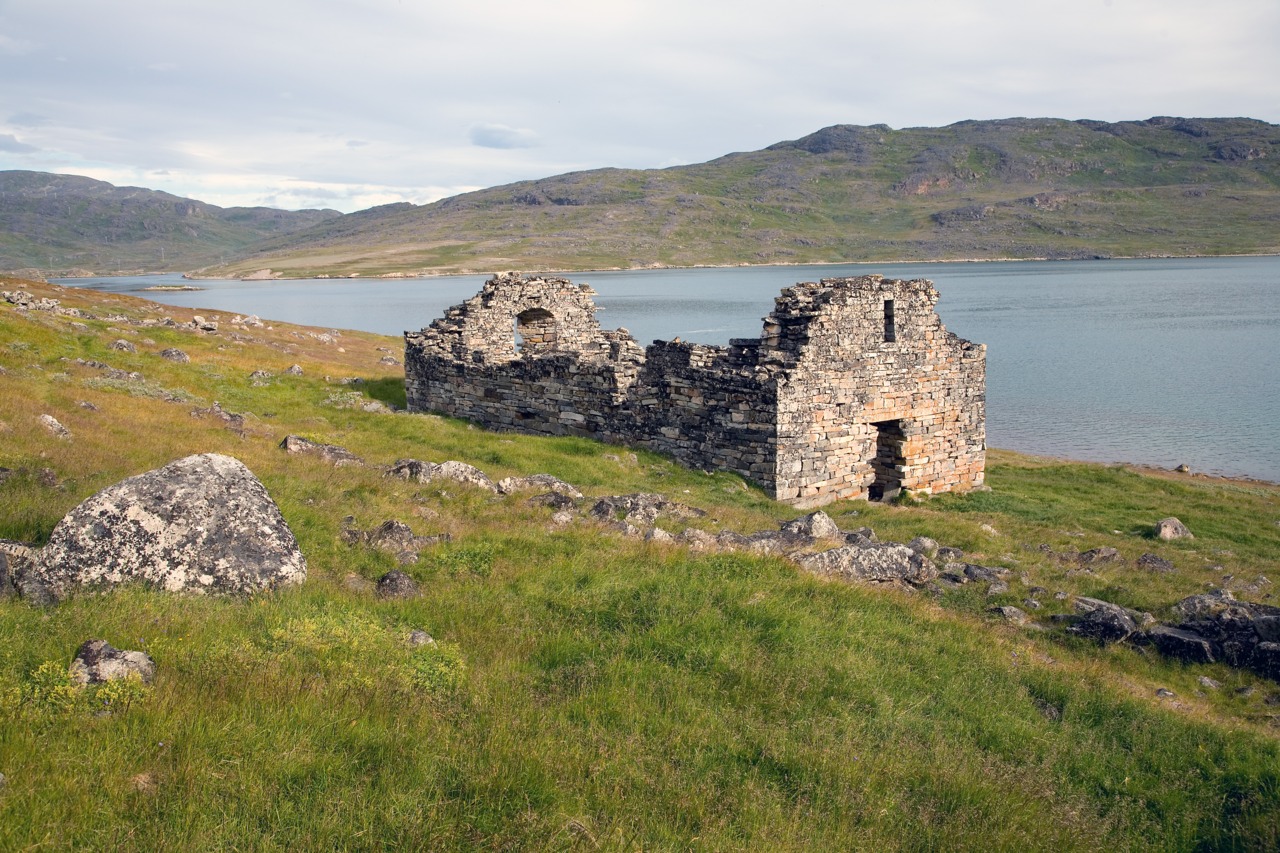
Hvalsey Church, Eastern Settlement, Greenland
Colonization is recreation. It features on board and computer games, from Simcity to Civilization, and from Settlers of Catan to Musk at Mars (ok, that one is apparently not a game). The games invite us to imagine a fresh start in a place where the past does not matter and where everything is a new adventure. It is to boldly go where no one has gone before. But it is harder than it seems. Our real lives are complex. We are dependent on interactions with others, and on products and services created by other people in different locations. We are not an island, and complete self-sufficiency comes at a high price. It brings fragility. And when things go wrong, help is hard to get.
Complete disappearance of a colony is rare. But it has happened. This post is about one such disappearance, one that shocked the world. It took 300 years for the remains of the colony to be found: some ruined farms and a roofless church. All traces of the cause of the failure had gone. Why did the Viking settlements of Greenland collapse? Was a volcano involved?
Viking settlers
Iceland was not an easy place for colonization. Still the Vikings went for it in their search for pasture. Getting there from Norway took about 10 days, a long journey in an open boat but doable for experienced sailors during the summer season. The migrants kept coming; over the next 60 years the population of Iceland grew to some 30,000 people. The migration declined when all good farmland had been taken. Eldgja (939 AD) finally put an end to this era of settlement.
But for some, Iceland had already become too crowded; it was no longer the land of opportunity. And so Vikings moved on from Iceland to Greenland and turned it into the most isolated European colony in the world.
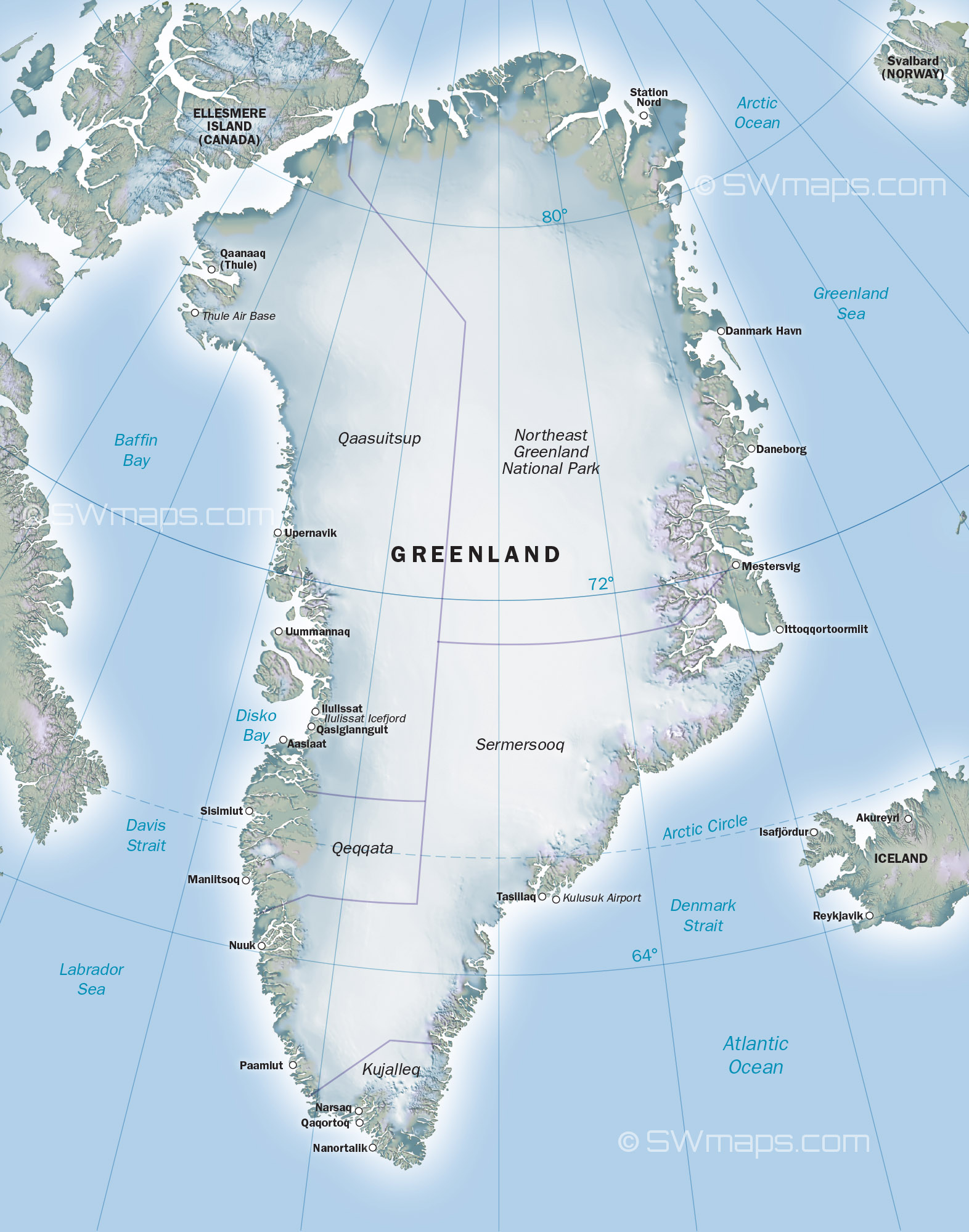
This was a surprising move. Greenland has the reputation of being a glaciated, uninhabitable wasteland. The glaciers are kilometers thick and cover almost all of the country. In the north and east the glaciers reach the coast. It is not an obvious place to start a dairy farm. But the west coast is different, and the climate is only a little colder than that of north Iceland. The southern tip of Greenland is further from the pole than Iceland and the sun and the wind from the high glaciers can bring some unexpected warmth. There are meadows here, along the deep fjords, and there are animals which call it home. Caribou roam the region. Greenland really can be green, in the right place at the right time. But the winters are long and the summers brief.
Eirik the Red (a colourful character) discovered the habitable regions on the southwest coast around 982 AD, only a few decades after Eldgja. He had been exiled from Iceland for bad behaviour (and that said something). Eirik decided to make it home, and starting his own settlement here. This required finding more would-be colonists. He called it ‘Greenland’ to make it sound more attractive, in order to entice people in Iceland to come with him to a new and empty world. The origin of the name was soon forgotten. Adam of Bremen, in 1072, wrote “The people there are green from the salt water, whence, too, that region gets its name. The people live in the same manner as the Icelanders except that they are fiercer and trouble seafarers by their piratical attacks.“ The people who made Greenland their home were as rough as the country they lived in.
Around 985 AD, 25 boats went on the migration, each carrying perhaps 30 to 40 people. Only 14 boats arrived: the remainder turned back before arrival, and some may have been lost at sea. Most of the around 500 people who came settled in a region just beyond the southern tip of Greenland. This was where Eirik had spend the three years of his banishment. It became known as the Eastern Settlement. (This unfortunate name caused serious problems later.) But 2 or 3 of the arriving boats moved on, and went further up the coast, 400 kilometers and another 6 days of travel away. This became the Western Settlement. These were the two main regions that were (somewhat) suitable for farming.
The first years must have been very hard. After the arduous and long journey, the settlers now had to set up home. Eirik and the people who had accompanied him in exile already had dwellings, but the others had to decide on a location, build houses, and hunt and farm enough food for the long winter, in just a few remaining weeks of summer. They managed, and over the next years more people came from Iceland to join them in their brave new world. The Eastern Settlement grew to 2000-3000 people; the Western Settlement may have homed 1000 people.

The Eastern Settlement in medieval Greenland. The known major farms and churches are identified, as well as some probable geographical names. Source: wikipedia
For centuries the settlements survived and even prospered. But it did not last. After four centuries, contact with Norway and Iceland was lost, and when people came to look for them the settlements could not be found. The rescuers were confused by the name, and searched for the lost tribes on the wrong side of Greenland, the ice-covered east coast. The search for the lost Greenland Vikings became legendary.
It took more than 300 years before the location of the two settlements was finally found. But there were only ruins, and they showed very little evidence of what had happened to the people. The discussions continue to this day. Some blame the worsening climate of the middle ages. Others give the cause as ecocide, with depletion of the local farming land and fishing grounds. English pirates have been blamed, or wars with the Inuit population. Speculation is rife and facts are few. The failure of the Greenland Vikings does not bode well for Musk on Mars, and it is important that we understand how isolation can lead to fragility, and finally to disappearance. It turns out that there were two extinction events. Were the triggers volcanic?
Greenland economics
Vikings were farmers. This is of course not what they are remembered for, but the looting, murdering, piracy and conquering much of the known world was a bit of a sideline to making ends meet. Farming in Norway was hit-and-miss, and when things went wrong or a new generation grew too numerous for the carrying capacity of the land, a bit of piracy seemed a good way to supplement one’s income, and perhaps reduce the overpopulation. When the Vikings moved to Iceland, they took their farm animals and culture with them. Norway has a cold climate and their way of life was suitable to the Icelandic climate. When moving to Greenland, they again did the same thing. The boats had carried not only the settlers but also their cows, sheep, goats and pigs. And all lived on a small open boat in difficult seas for weeks. Just imagine the smell!
The Greenland settlers never build towns. Instead they build farms of a variety of sizes, ranging from single family dwellings to large manors which supported tens of people. Some outlying buildings were occupied only in summer. The farms were typically 1 to 5 kilometers apart. You do get the impression that the Vikings needed their distance from each other! The Western settlement consisted of perhaps 90 farms; the Eastern settlement was a few times larger. The farms were located along extensive and multi-armed fjord systems. Each of the settlements extended over 100 km! The farms were mostly located quite far in-land where the climate was a bit better suited to farming. This is a second reason why the search parties took 300 years to locate the ruins. They were looking along the coast, while the farms were mostly in-land.

A typical area around the Eastern Settlement
There is a limit to what farming is possible in Greenland, and in the Western Settlement this was even more restricted than in the milder climate of the Eastern Settlement. Grain would not grow and bread did not exist. Some root vegetables were grown. Iceland is fertilized by frequent volcanic ash. Greenland is not, and it is ancient rock. Glaciers have scraped the ground down to the bedrock, and around the Eastern Settlement this bedrock is a staggering 3.6 billion years old! It has long lost any fertility it may have had. The farms were completely dependent on what patches of soil there were. They were dairy farms with a small herd of cows providing milk. All suitable soil was used to grow the hay that was needed to keep the cattle alive during the long winters. Poorer fields were used for sheep. The hay was supplemented with anything else they could get, including some seaweed. The cows stayed inside (in the houses!) for 5 months (Eastern Settlement) to 7 months (Western Settlement). The calves were born here. At the end of the winter, sometimes they had to be carried outside, being too weak to walk. In autumn, famers would need to decide how many cows they could keep through the winter.

Reconstruction of a Viking long house. Source: Erik Painter
Hunting supplemented the meat. Caribou meat was especially valued. Seal meat was eaten when caribou was not available, but was not the preferred meat: the manors mostly ate caribou, the poorer farms ate seals. Fish was taken from the rivers and lakes, but not from the open sea. The Greenland Vikings (unlike those at Iceland) used no nets or harpoons, only hooks. Seals were hunted in the spring on their breeding ground on the shore.
The big attraction of living in Greenland, though, was something entirely different. Walrus tusks were highly valued for their ivory, and this became Greenland’s dominant export product. Iceland’s supply of walruses had been quickly exterminated. Greenland had unlimited numbers. Their ivory made Greenland economically viable. The walruses were hunted at Disko Bay, 300 kilometers north of the Western Settlement. Hunting parties from both settlements would go there. Disko Bay was perhaps the reason why the Western Settlement had been build in such a marginal location. Not only could the people here travel to the walruses much quicker, they could also set off earlier in the season. Drift ice from East Greenland could block the fjords of the Eastern Settlements until June, whilst the Western Settlement had much less drift ice: they could go to Disko Bay as early as April. Within a century of Eirik the Red, all ivory in Europe came from Greenland.
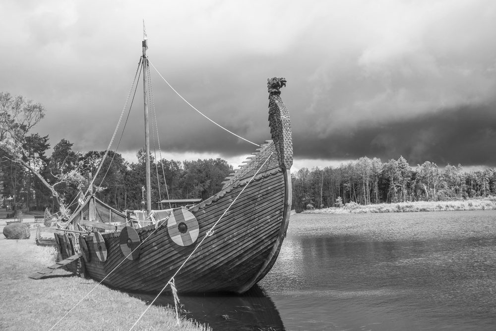
A Viking long boat
Because of the shortage of wood, Greenland eventually lacked the boats needed to trade their ivory themselves. They depended on visiting traders. In later years, one Greenland boat which managed to reach Iceland caused a bit of a sensation, by being so small and because it lacked an anchor. That was a second lack: Greenland had no iron.

Newfoundland
The journey of the Vikings did not end in Greenland. A bigger prize was beckoning, and it became important in filling the gaps in Greenland’s economy: America.
There are two versions of the discovery of America. I will follow the Greenland saga which seems the more likely one. One of the original settlers of Greenland was called Herjolfr. He had left Iceland while his son Bjarni Herjofsson, was away in Norway. Bjarni went looking for his father, but wasn’t sure where this Greenland was. Driven too far west in a storm, he sighted a land with trees and mountains. This clearly wasn’t Greenland, and Bjarni backtracked to continue his search, without stopping. He managed to eventually find Greenland, and remained there with his father. After his father’s death Bjarni returned to Norway. The land he found sounded rather enticing, and when Bjarni left, Eirik’s son Leif bought Bjarni’s boat and went looking for this land. (This already indicates a lack of sufficiently large boats in Greenland.) Eirik himself stayed behind in Greenland. This happened around the year 1000.
The new land improved as Leif’s party sailed south along the coast. They gave it descriptive names: the northern area including Baffin Island was called ‘Helluland’ (slab land), south of about 60 degrees latitude it was ‘Mark land’ (forest land), and further south (Nova Scotia and perhaps around the St Lawrence river) they called ‘Vinland’ (wine land). Slab land had little to offer apart from foxes, and the winters here were much more severe (and snowy) than in their Greenland homes. Forest, though, was a very valuable find and grapes would have been out of this world for a people having neither wine nor beer. The party wintered in Newfoundland, and returned to Greenland the next year with their new-found treasures.
After this the story becomes vague. A settlement was started in the new land, from where they would travel south. This settlement was discovered at L’Anse-aux-Meadows, at the northern tip of Newfoundland. There may have been a second camp further south. Women joined the party, and a Viking child (‘Snorri’) is said to have been born in North America. Archaeology has shown that the people at L’Anse-aux-Meadown included Icelanders – it was not a purely Greenland exploration. The child was said to have ended up back in Iceland. There may still be people in Iceland with a North American link in their ancestry!

The big house at L’Anse aux Meadows. The entryway is in front, the sleeping quarters in the center. To the left a boat repair area, and to the right storage. Source: wikipedia
The travels to Newfoundland had a clear economic benefit. The Vikings needed wood for their boats and their houses, and there were trees at L’Anse-aux-Meadows. Iron too could be obtained from this region. There was also hunting, but the winters at L’Anse-aux-Meadows were quite severe (more so than at their homes in Greenland) and the game was scarce. This is one reason why there may have another camp further south. Around 100 people would have stayed at L’Anse-aux-Meadows.
How long the settlement lasted is not well known. The sagas talk about the conflicts with the local population, and also about murder in their own ranks. It appears that the site was abandoned within a century, perhaps even within a few decades. After that, Vinland was out of reach for the Vikings. But summer journeys to Newfoundland (or Markland) continued long after. Even at late times in the Greenland settlements, their boats and coffins contained larch wood which only grows there.
Why did the American settlement fail? In the end, they lacked the numbers to grow into a viable colony and to defend themselves against the local population. Greenland was settled by about 1 in 20 of the Icelandic population. L’Anse aux Meadows housed about 1 in 20 of Greenland’s population. Greenland was perhaps just too small to support another colony. If Eirik the Red had gone a bit further on his first attempt, straight for North America, a viable colony might have been possible and history could have been very different. But he didn’t.
Decline
The two Greenland settlements did well for centuries. These were not marginal societies. Farmers were never wealthy, but they made a living and ivory provided income. Churches were build and even stained-glass windows were imported. But over time, cracks were showing. The lucrative trade in ivory remained important until around 1300. But after that it declined. In part this was because other sources of ivory had become available, but a more important reason was Norwegian politics. In 1294, the Norwegian king decreed that all trade had to be done on the Norwegian royal vessel. The aim was to make sure that taxes were paid, but it severely limited trade and import. The vessel came irregularly. It also never went to the Western Settlement, because adding this trip to the journey would have required the vessel to overwinter in Greenland. The Western Settlement had to bring their taxes (paid in kind, with ivory and walrus skins) to the Eastern Settlement and received little or nothing in return. In comparison, the Eastern Settlement still did well enough to build a small cathedral.
By the middle of the 14th century, trade with Greenland had diminished so much that in Europe ivory became in short supply. This reflects the lack of shipping opportunities. It became even worse during the years of the Black Death when few ships sailed the North Atlantic. (One visiting bishop in Iceland was stuck for four years because no ship came for him.) The Norwegian royal vessel was itself lost in 1367 and after that there was little contact between Norway and Greenland. A consequence of the diminishing trade was that the Black Death never made it to Greenland. It did get to Iceland, though with 50 years delay.
In the absence of trade, we do not know whether the hunts at Disko Bay still continued. The contacts between the Eastern and the Western Settlements had been decreasing. Travel between the two took 6 days, and was only possible in summer when there was much else to do. After a while, the only recorded visits were to pay taxes. The last such record was in 1327.
The Eastern Settlement also became isolated. The last documented visit by people from Iceland was in 1406-1410, with circumstantial (and unconvincing) evidence that the same people returned in 1418-1420. After that the Greenland Vikings were never seen again, at least by people which documented the visit. This was the time that European fishermen began to frequent the Newfoundland region for cod. New designs for boats had improved speed of travel, and now it was possible for the fishermen to make the journey within one summer. Before that, they would have had to winter. There may have been contact between the fishermen (mainly from the Basque region and from Bristol) but this is speculation.
In 1410 all had been well with the Eastern Settlement. But within decades it would be gone. Archaelogical evidence shows that the best farms reverted to wild meadows around 1450. At the very least this means there were no longer any cows, and at the worst it means there were no longer any farmers and the last true Vikings were gone.
It took many years for the disappearance of Greenlanders to be noticed. After 1500 even the pope expressed concern, and expeditions were planned to find them. But by that time the location of the settlement had been forgotten. People searched the east coast, opposite Iceland, being confused by the name ‘Eastern Settlement’. But this coast is unreachable due to ice. John Davis visited the western coast several times around 1585 while searching for the northwestern passage but he did not find anyone. The settlement was rather far from the coast, of course, and would not have been visible from the sea. The Eastern Settlement was found only when a Norwegian missionary, Egede, spend a winter on the coast, barely survived, and decided to move further in-land. He traveled widely in the area, and his Inuit guides showed him the remains of the Eastern Settlement, including the roofless church of Hvalsey. This was in 1723, almost 300 years after the failure of the colony. Egede, and others after him, thought this was the Western Settlement and that the Eastern Settlement would be on the east coast. This expectation was only disproven in the late 1800’s. The North American settlement at L’Anse aux Meadows was found only in 1960. It really is possible for nations to be fully lost.
Archaeology has shown that the decline of the Eastern Settlement had happened over many years. The outlying farms were abandoned first and people moved closer to the better ones, perhaps in servitude. The abandoned farms were carefully demolished to save the timber – remember that wood was a precious commodity in a place without trees. That already shows it was a managed decline. It is even possible that people slowly migrated back to Europe when the British and Basque fishing vessels began to frequent the area. In any case, by 1500 and perhaps already by 1450, none were left.
The fate of the Western Settlement was different. It had ceased to exist much earlier, and so suddenly that not even the Eastern Settlement ever found out what had happened. A settlement that had existed and flourished for 350 years had been wiped out by a disaster. Was a volcano to blame?
Part II: demise of the the Eastern Settlement
Albert, June 2021


It always amazes me how far the Vikings ventured in their open ships. Without doubt they were well built and thoroughbreds of the time. I’ve seen the ones in Oslo, and the impression they leave is very strong.
Thanks for a fascinating look at this time. As ever, beautifully written.
Ahem – thoroughbreds as in the ships, not the Vikings… 🙂
A pretty apt description of Oslo either way.
For the readers here it is of interest that the Icelandic Hotspot still has impact on Greenland. The ground where it passed rebounds much quicker than the surrounding ground as it has more heat in it. This leads to incorrect previous calculations of the ice loss on Greenland. It is actually around 7% higher than we thought one year ago.
No active volcanoes on Greenland though. 🙁
It should’ve been “and it has more heat in it”, nothing else.
At 19.30 (4p min ago) it is possible to see the lava flow over the saddle from Gelingadalir.
40 minutes ago.
Fascinating. Thanks, Albert. I look forward to the sequel.
Am enjoying the Albert Viking article.Recently had a DNA test showing am 1% Norwegian ancestry,rest is Irish. The 1% no doubt Viking link- though many of the Irish and the island off their cost could claim the same.
Remember that these percentages have many caveats, not least being that they are based on groupings determined by the self-selected sampling inherent in DNA analysis. Your percentages would be different in another company’s data set.
Recently, it has been suggested that the colonies in L’anse aux Meadows and Vinland were helped by the Inuit to travel northwest to an undocumented area, perhaps interbreeding and settling with the Inuit eventually. It seems to be as much based on speculation as evidence though.
There were no Inuit in this area at the time so this is not possible. They did not arrive in the southern part of Greenland until the 14th century. The Vikings did have contacts with the Indians (which they called ‘skraelings’) but those turned rather quickly to violence.
I think it was suggested the help was after they started travelling away, rather than in the area they settled. The evidence was thin and was probably closer to a theory than anything else. There was talk of the northwest passage, which is presumably the same route later explorers took.
I suspect there was also an assumption that the Dorset Palaeoeskimoes and Inuit are one and the same.
The western wall was still holding as at 19:42, despite what appears to be a sizeable amount of lava going over the saddle.
Oops! The last image was supposed to be the link to the source for the screen shot.
A close up, now the mist has lifted:
]
Link as before.
Nice that the RUV cameras can be rolled back. It makes it possible to catch up with most significant events.
I suppose that till the morning the wall will be overcomed….should we start betting?
http://brunnur.vedur.is/myndir/listi/webcam_langihryggurNV.html# at 22:40 shows lava steady veins toward wall corner, meanwhile heavy lava volume is expled….
Camera is zoomed now.
Not big river till now, but can attack the wall any moment.
Kilauea GPS is going to the moon, will surpass the December value with the next point at this rate, a matter of a day or two. Also of note since the eruption ended the DI events dont show on the GPS anymore, only the tiltmeter.
I wonder if the lava lake crust is thick enough to survive a vent opening at the bottom of the lake, it is a few months old in places but in 1960 the Kilauea Iki lava lake crust was only a few meters, 5-7 I think after almost a year and the 2021 lake is much deeper, the middle probably has hardly cooled at all since being erupted and will still be fluid. A vent opening might cause the whole thing to founder, that would be a sight to behold, as the entire crater lights up like a portal to hell.
well, i’ve known Bishops that i would have forgotten to return and pick up for more than 4 years….. 😉
There’s one despicable Bishop that I’d happily throw off Beachy Head. Justice has finally caught up with him, and DNA played a part in that.
Yes – the story didn’t say whether it had been carefully planned ..
I don’t know if this was posted earlier. Looks like the western wall, doesn’t it? Or is it somwhere else?
http://brunnur.vedur.is/myndir/webcam/2021/06/05/webcam_meradalir_vestari_varnargardur_A.html
i think You are right! Good catch…
That is indeed the western wall, it even says so in the link name 😉
With a refresh rate of every minute!
Oddly, I saw a car on the slope, and a couple of people working in exactly that location a few days back. I did wonder if they were putting in a webcam – and now we know! Thanks for finding this, llavalamp!
Unfortunately the time list is not currently in the table, it is in a long column causing the image to scroll up off screen! 🙁
And it’s been added to this spreadsheet, I don’t remember where I got this, probably from a live chat on one of the Bob/Flo/Rag webcam streams.
https://docs.google.com/spreadsheets/d/14MWPPQ3SeEGquYy1JvPei3teL-ly0EQMitCzkEAsbsc/htmlview
Is anyone else getting a ‘forbidden’ message for this camera now?
https://grapevine.is/mag/feature/2021/06/04/the-message-in-the-magma-the-geldingadalir-eruption-site-is-growing-what-have-we-learned/
Going to last a very long time
The article is very clear and well written. The photos are pure comedy gold!
Thanks for linking Jesper, very good read. Recommended!
Interview with geochemist Sæmundur Ari Halldórsson, Háskóli Íslands, about the change in composition seen in Geldingalir’s lava.
So, even as the cone and surrounding shield grow on the surface, via decompression melting it’s burrowing a taproot deeper and deeper into the mantle beneath the eruption site.
Its now a superhot picrite basalt
Well over 1200 C and very runny close to the vent. The sillicate content is around 50%.. but its the High Temperatures that lowers the viscosity here .. making it very fluid close to vent
The eruption seems to be declining today. The surges a few hours ago were overtopping that rock jutting up from the middle of the exit ramp, gushing over the side, and spilling down that whole apron at the front; now they do none of those things. The level of the lava at the back used to rise to the top of the back rim behind that jutting rock, and now barely reaches near the height of that rock, whose top is a few meters lower.
At the same time, this site is glitching. It showed 329 comments with the last being “Bjarki 07/06/2021 at 20:39” on a previous load. When I reloaded it a while later it showed 335 comments, indicating that there were six new ones, but I could only find five. Four were added below the Bjarki comment; the fifth was back on page 2. I searched all three comment pages for the string “07/06/2021 at 2” and found only five comments more recent than the Bjarki comment, so my search was exhaustive and cannot possibly have overlooked anything.
Where is the sixth of those comments?
I looked – there were only 5 valid comments. We have no record of a 6th comment
At 01:00

Bjarki , hey good one!
2021-06-04: The seismic data, recorded today, indicate little change from the situation on June 3rd. The GPS network did not detect any displacement at the stations today. The physical impossibility of installing seismic or GPS stations in the lake does not allow for accurate detection of possible magma upwelling under the lake. Further rockfall in the crater remains possible and could cause ash fallout in the surrounding areas. The favourable development of the situation continues, although a resurgence of activity cannot be completely ruled out. This justifies the continued intensive monitoring and daily reassessment of the situation by the GVO.
https://georiska.africamuseum.be/en/news/nyiragongo_eruption
Now that the fog has bugger off, am surprised gow wide the saddle flow is! I thought it be a narrow crossing of lava, probed myself wrong.
‘how wide’
In the brief gaps in the fog cover, a large lava flow is seen moving in from the right on the Langihryggur camera. It is keeps going, it will be deflected out towards the middle of the flow field by the fan which has been built below the neck.
It could come back in towards the western wall, of course, but at the moment, the wall is paradoxically enough being protected by the flow that came over the neck.
A few crude calculations.
We know from the June 2 figures that the area of the lava field is 2,670,000 m², and the current flow rate is 12.4m³/s, which equates to approximately 1.1 million m³ per day, 7.5 million m³ per week, or 32.1 million m³ per month.
Assuming the lava field doesn’t grow in extent, those flow rates are sufficient to increase the height of the entire field by 2.8m per week, or 12m per month.
Of course the field will grow, nor is deposition constant across the area, but it gives an idea of the amount of change we are likely to see.
Example of some change – close-up video of the saddle overflow – it’s huge!
Impressive though this is, at this scale (that is geographic scale) I think cu km is better even though there are 1billion cu m per cubic km. Really we need a new unit that is 1/1000th of a cubic km perhaps standardise on Mm^3 and Mm^2?
For English readers, the novel Vinland The Good by Henry Treece is a great introduction to the start and the approaching end of the Greenland settlements. All the characters in Albert’s tale appear, and it’s written in as good an English approximation to the laconic, Hemingwayesque tone of the Sagas as a Brit can manage. “Stark” is probably the right word. Treece wrote several Viking age novels.
Albert didn’t mention Freydis, though – that was one mean woman.
https://en.wikipedia.org/wiki/Henry_Treece
https://en.wikipedia.org/wiki/Vinland_the_Good
Video of saddle recently uploaded:
https://youtu.be/hiD5qwDqmrE
Repeat of Philip Daniel’s post above, could it be deleted?
There’s a river of new lava heading for the western wall (still in tact when last visible). As far as I can tell with the poor visibility, it did not come from the saddle (that was still making its way across the lava field when I could last see it).
Source: https://www.youtube.com/watch?v=BA-9QzIcr3c
Typo in the email address?
Lava heading for the western wall
Source: https://www.youtube.com/watch?v=BA-9QzIcr3c
Source of the lava river:
Source of image: http://brunnur.vedur.is/myndir/listi/webcam_langihryggurNV.html#
10:29
Source as above
Good capture. Al the end, the main flow to the wall comes from the river-lave, plus the new cascade.
I get a ‘forbidden’ or ‘not available on thios server’ message. I’m using firefox?
The Western Wall is overtopped
http://brunnur.vedur.is/myndir/listi/webcam_meradalir_vestari_varnargardur_A.html
Direct link to the latest image
Hmm…you can animate these cameras with the right/left cursor keys. No need to go through the whole day.
Dang, beat me to it. Didn’t see your post before I posted.
10:19 – lava overtopping the western wall.
http://brunnur.vedur.is/myndir/webcam/2021/06/05/webcam_meradalir_vestari_varnargardur_A.html#
Lava flow progressing very quickly, based on http://brunnur.vedur.is/myndir/webcam/2021/06/05/webcam_meradalir_vestari_varnargardur_A.html
The flow became visible at 9:49. By 10:17 it reached the wall and by 10:20 the wall was breached.
Awesome!
Direct link to the picture at 10:20
https://www.volcanocafe.org/wp-content/uploads/2021/06/webcam_meradalir_vestari_varnargardur_A_20210605_1020.jpeg
moved image to faster storage -admin
The breakout started between 08:10 and 08:20 from the lava wall(?) on the right of the image
Source: http://brunnur.vedur.is/myndir/listi/webcam_langihryggurNV.html#
That person right in front was playing a very dangerous game, that is some fast lava. I suspect it is already at the bottom of Natthagi now at that speed and will go a lot further than the other overflow did.
10:25-10:27 – Good grief! He really had to run for it. That lava was shifting.
I reckon it actually went around the edge first, then the force and capacity of the flow caused overtopping. In both cases, the walls themselves seem to have held solid until overwhelmed. This is good data for diverting and delaying flows.
There was just the briefest of breaks in the fog on the langirhyggur livestream and the lava channel is impressive to say the least, either the whole wall failed and the impounded lava was released or most of the eruption is being funneled here, it is a way bigger flow than the other Natthagi flow ever was.
This is the sort of flow that could make it to the ocean in a few days, if it keeps up.
Latest view

Something for Hector, or anyone else who is interested in Hawaiian eruptions. I think I might have found something pretty profound here.
Map of all those massive ground cracks in the middle east rift of Kilauea, where Pu’u O’o is now. Red is eruptive vents:
https://imgur.com/a/uCc0krv
And with lava flows included:
https://imgur.com/a/fXeRpgU
Those old 1954 aerial photos of the area east of Napau crater show lava flows going into these cracks and seemingly also erupting from them at other places, indicating they were contemporary events, and you had a theory on a massive lava lake draining from Napau crater Nyiragongo style into the lower east rift. Seems a very plausible case that the ‘1790’ fissure in the north part of Leilani Estates is that exact eruption as it lines up very nicely with those ground cracks going almost continuously the whole way up to where Pu’u O’o is today.
It seems that there was a pretty major eruption in the middle east rift between 1790 and the eruptions that created Heiheiahulu, around 1760 or so, way bigger than anything similar we have seen recently. If the accounts of an eruption in the Leilani area around the time of Cooks visit are to be taken then we have a rough date of about 1776. This would have been a massive curtain of fire lava flood eruption with lava filling up Napau crater and flooding the terrain downslope, Mauna Loa style, probably the biggest eruptions in this part of Kilauea up until Pu’u O’o and much faster.
Ellis wrote something like this: “During the reign of Terreoboo, the friend of Captain Cook, a great torrent of lava was dammed behind the hills of Kaliu, Malama and Honualua so that it didn’t overflow the Malama district”. That must have been in the 1780s or so, I do think it could have been the catastrophic draining of the lava lake that filled Napau. Perhaps some of the lava flows in the MERZ are also from the same eruption like you say, although in all likelihood there were other eruptions too.
Aloi and Pauahi craters contained small cooled lava lakes of 18th century age, and those are in different fissure swarms from Napau that could not have erupted at the same time, so activity was generalized throughout the ERZ. Paleomagnetism indicates that most of Lower Puna was resurfaced by lava in the 18th century, including Heiheiahulu in Alapai’s reign, the “490 BP” flows (which are not so old), the fissure of the 1780s, and other eruptions probably.
My interpretation is that there was a big fissure eruption in this area, maybe like that of 1965 only a lot more voluminous. It must have been a massive event to not only flood over a wide area downslope but also fill Napau crater a significant way as well as possibly Makaopuhi. It is either during this eruption or maybe slightly afterwards that the lake draining occurred, probably with little else to do with the other eruption and very abruptly. There are flows that go into the cracks so I think there was probably more activity afterwards but as the historic period has shown this could have been within months or a few years, the same area erupted in 1961, 1963, 1965 and 1968 from one fissure. It also seems a possible time for the creation of those pit craters south of Napau, which line up with the fissure.
Whatever happened here though was a major eruption, to borrow the Icelandic term it was a fires event, and a big one at that. My best estimates of the volume are a total of close to 0.5 km3.
Yes, it does seem likely that there must have been some intense fissure eruptions along the Napau fissure swarm, maybe more than once I’d guess. Those would be quite a show.
Napau is also the longest swarm that is well connected to the summit, a proper fissure eruption would be 20 km long, as long as the 1950 eruption of Mauna Loa. In that sense I see what you mean by Mauna Loa style. Nyiragongo style is even better though, or worse if you are near.
It is a very interesting area, unfortunately one we will have to learn the hard way too, Pu’u O’o buried it all and there was never any proper study done. It is really almost too late to try now too.
There might be a magma body around Pu’u O’o now, it looks like the pit craters tend to be associated with shields. The pits around Mauna Ulu all seem to be related somehow to Pu’u Huluhulu, which is kind of a failed shield maybe 500 years ago or maybe a bit less, after the Aila’au eruptions. Napau and Makaopuhi are related to Kanenuiohamo which you said is probably around 1000 years old, and is about as big as Pu’u O’o. I expect a chance of pit crater formation at or near Pu’u O’o in the future some point.
Seems to me that the part between Pu’u O’o and Napau, and the area east of Pu’u O’o is at risk of a big flow much more than is considered. I dont mean a passive lake draining either but an actual curtain of fire eruption, high fountains, like the start of 1960.
By related I mean all the pits up at chain of craters were from magma pockets draining after Pu’u Huluhulu formed, but the draining was much later on. It is probably complicated here, but Napau and Makaopuhi are definitely related to Kanenuiohamo.
Loihi Seamount activity ??
Looks like some-thing’s stirring under Loihi, that sea-mount ~30 km SE of Hawaii. A could-be-next-island mini-me that’s grown ~3 km from sea-bed, but has another ~1 km to go before it can do a Surtsey. So, not ‘soon’..
If getting magma intrusion there, does this take pressure off activity ashore ?
No, Loihi is not big enough to really do anything to Kilauea yet, it may never be. The volcanoes are also not hydraulically connected, otherwise Mauna Loa would collapse and Kilauea would have a flood basalt scale eruption, and I mean an actual flood basalt flow, not just a mere Laki event. Or indeed both of them would collapse and Loihi would erupt (and likely completely self destruct) in much the same way under the ocean…
There is a hotspot pulse at Hawaii, Kilauea is obvious but Mauna Loa has been much more active than it was in the later half of the 20th century, it would be expected Loihi is joining in, though there is no way to monitor it and no reason to really.
New overtopping ?

No doubt there’ll be lots more….but as there is lava “hardening” along the bottom of the south side of the dam, chances are good (yeah, I know…”Hold my beer”) that the dam itself might well stay intact.
Who knows how deep the channels that might be cut into the topmost of the dam, though.
I just looked in at the camera, and more is coming over the top of the wall. I’d guess nearly half the dam is overtopped. It will be interesting to see if the lava will erode the soil. It is such runny stuff, it may go off to find an easier route like the one already established.
If we get another major pulse from the vent, that would be curtains for the wall, so to speak!
The flow in Nattaghi has expanded a lot with the demise of the wester wall. The pond is now under attack
Nice drone shots over the footpath. Must have been some sight to see it.
https://youtu.be/JyPw_W4OaB4
Nice!
Looks exactly like a frozen waterfall. Both on the top side and the frozen ‘rapids’ towards the lower end…
Funnily enough I just read this article on a mantle plume under Greenland yesterday that feeds Iceland and Jan Mayen. https://scitechdaily.com/newly-discovered-greenland-hot-rock-mantle-plume-drives-thermal-activities-in-the-arctic/
I believe there is a geothermal pile under Greenland – in fact the subducted Sisimut slab suspected to be aged between 110-170ma was imaged under south western Greenland. This coincidentally is where some volcanism did occur (Illugisoq stratovolcano for instance) – albeit this is more likely to have come about as a result of the failed Labrador sea rift and the seafloor spreading at the time which opened up Baffin Bay – and which may or may not have contributed to a Greenland microplate!
Certainly Greenland has a volcanic not so recent past, and probably had a thin layer of fertile soil in the Western Settlement that supported hardy crops for a time, but it would have been a hard life.
Hey all. What was the big signal on the ISS high pass drum plot at 9am today?
Did someone stamp the ground by it? No one has mentioned any big explosions from Fagradals not any earthquakes seem to have been reported
Thoughts?
Hi all,
A timelapse from Langihryggur, just after the overflow at the saddle and a bit in the morning.
All the other hours there was no visibility due to the persistent fog.
Still, it gives an idea of the new lay of the land.
https://youtu.be/B3s9Zh1b3NY
Thank you Virtual, much appreciated.
So, it takes 300 years to find the “Eastern” settlement, 450 years to find the Western settlement and around 500 years to find the Canadian settlement. And it takes only 60 years for Plate Tectonics to develop to the state we see now. What a change.
Thank you for the interesting historical excursion.
Couldn’t this be one of the consequences of the middle of century-mystery volcano, possibly Kuwae?
If you include Wegener’s abortive attempts to foster moving continents, it’s a lot longer than 60 years…
Sure, he was a visionary. But he died young in 1920, and then things didn’t develop for a while due to economical turmoil and war. Harry Hammond Hess shouldn’t be forgotten either.
Nattagi on the move:

at 18:14 was touched….i suppose that till morning will be history
Lots of overflows at the dam now (1900+) from the RUV camera.
Maybe we’ve been so studious in wanting to appease the volcano gods, the meteorological gods were overlooked and got their vengeance during the saddle/dam breaches.
🙂
As seen on the MBL camera, more lava flow along the east side of Theatre Island.
Quite an increase in flow down the hill at West Dam at about 1916 as well, on RUV camera.
At 2023 on the RUV camera, it appears that the additional flow on the east side of Theatre island is coming to add it’s volume.
Wonder how far along the ‘defenses’ are coming in the Natthagi Valley. Seeing the success of the West Dam in delaying flows, are they going to use staggered (angled ?) walls….one side open so there can be “some” flow?
His name was Snorri Thorfinnsson
https://en.wikipedia.org/wiki/Snorri_Thorfinnsson
https://twitter.com/krjonsdottir/status/1401264779319197702
Lava is now flowing over the w-barriers in S-Merardalir (Nafnlausi) #Fagradalsfjall
High speed flow down to Natthagi Valley now on the zoomed in camera.
Well, the toast is going to get burned!!
//refering to the “lake toast” from the early crazy youtube days chats.
PS.
The “magmalade” will not improve the taste this time.
//llavalamp takes cover…..
Descendants of Snorri Thorfinnsson:
“Snorri was born to Þorfinnur “karlsefni” Þórðarson and Guðríður Þorbjarnardóttir. Guðríður had previously been married to Þorsteinn Eiríksson, a son of Eiríkur Þorvaldsson (Erik the Red) and a brother to Leifur (Leif the Lucky) and Þorvald.”
https://hobsonschoicegenealogy.ca/2018/01/04/snorri-thorfinnsson/
Great article.
Decode genetics here in Iceland did a study a few years back to investigate if Norse DNA had intergrated into the Inuite population. The results were negative. No interbreeding.
Another interesting discovery was made while studying the mRNA of Icelandic women.
A haplotype belonging to an extinct Native American tribe was found among women that traced their ancestry to Skaftafellssýsla southwest of Vatnajökull.
This particular haplotype has not been found anywhere else in Europe.
“Another interesting discovery was made while studying the mRNA of Icelandic women”
mRNA or mtDNA? I thought it was only mitochondrial DNA which was passed directly down through the female line.
I thought it was mainly about 50% Scandinavian mtDNA, 50% Celtic (Irish/Western Scotland) mtDNA. Maybe an Icelander had an Inuit wife and daughter.
Surprised at the lack of Norse DNA in the Inuit, or are we looking at old burials?
When the polar explorer Wally Herbert was buying sledge dogs for Antarctica in the 1960s (I think round Disko Bay) he noted how the features were changing and also that the Danish crew of his ship were “in great demand as lovers along the coast”.
By the way, when I try to view the vedur.is webcams like
http://brunnur.vedur.is/myndir/listi/webcam_meradalahnukurSSV.html
I get the message
“Forbidden – You don’t have permission to access /myndir/listi/webcam_meradalahnukurSSV.html on this server.”
Anyone else getting this?
I’d love a more zoomed in and zoomed out pic of the lava slowing over the western wall. Where’s someone with a drone when you need them?
Nátthagi cam
Did somebody already post the new mbl view to Natthagi?
Thanks for that – great addition to the stable of cameras!
Thank you. I saw screenshots and clips on Twitter but couldn’t find a link.
Nooooooooooooooooo not The Rock! Save the Rock!
The poor rock ☹️ Soon no longer to be viewable on google earth.
Soon to be entombed for all eternity… Unless the lava pushes it…
Thanks for the link, as I seem to be bloked now from all the Gevertungur time-lapse cams 🙁
Same here, don’t know why.
“Forbidden
You don’t have permission to access /myndir/listi/webcam_meradalahnukurSSV.html on this server.”
The toast is toast.
New (I think) Mbl cam
@ 2101, finally (not being nasty here…) RUV camera did a pan…pretty amazing stuff!
I understand the RUV is the Iceland equivalent of the BBC. MBL.is is a private broadcaster? I wrote to RUV today to suggest they move their Geldingadalir cam to ‘Theatre Hill’. I have to say I hope they take the trouble to upgrade the feeds a bit, the encoding quality looks poor in comparison to MBL.
I think there’s a lot of difference between the hardware that MBL uses, compared to RUV…better resolution and control.
And expensive doing the sacrifice thing too!
Moving a camera up to Theatre Hill (Island now? lol) would be a great idea….if it was a rig with four cameras, maybe on a 15/30 second frame shot. Should be cheaper than the PTZ, and cheaper for better resolution too. But I’ll take PTZ cameras all over the place!
Is there a link for that still camera at the West Dam, or was that a one off kinda thing?
Long river
Nice zoom out on the volcano in Geldingadalir, seen from Langihryggur, Iceland, 21:05:00
Something slightly different, Grimsvötn. The vertical black bar is (almost to the pixel) the difference between where the graph is now and the eruption in 2004. I’ve then copy/pasted the same black bar and put it in at various spots. To my eyes it looks like we are just one big quake away from a possible eruption in Grimsvötn, or the graph my rise the same “distance” over a longer period with many small quakes before anything serious happens. So in short what I think I’m saying, it could go bang tommorrow or in a year. Would that be a correct interpretation?
Just looking at the CSM 5 line it should take a large quake only indeed to reach it. Meaning eruption? I doubt it. The steepness of the curve might be of more importance here after all; the unrest caused by the build up pressure in the magma chamber(s). It is not busy as it was before the two previous Grims eruptions.
Grims neighbour Barda erupted Holuhraun and (trusting the 5 Nm line should be crossed for new action) that is a fact that has large consequences for the build up pressure under Grims in my opinon.
The GPS graph of GFUM/GRIM show a wave curved pattern before Grims previous eruption. Such pattern is frustrated in 2014 much by Bardarbunga. It still doesn’t show the finish of the expected form (s or counter – s).
Big wait…
On camera it appears that eastern end of the western wall has collapsed and lava flows through a gap rather than over the top. But the perspective can be deceptive so I’ll wait for local information on this
Looks very much like it is over the top from this angle, at 0:48 https://youtu.be/me-oCF03pyw?t=48
Judging by the torrent of lava now pouring into Natthalgi, I thing we can wave goodbye to the dam.
And is it me? The vent appears to have suffered a major wall collapse right around the rim?
Looking at the cameras, it is glowing and appears to be pouring lava out continuously.
Two weeks ago, I’d agree with you. Right now? Naww – I’d hold on my bet with that.
Time for lava to ‘solidify’ a bit, much of the general movement appears to have gone to the East Dam. Not to mention it does whatever the heck it wants to!
🙂