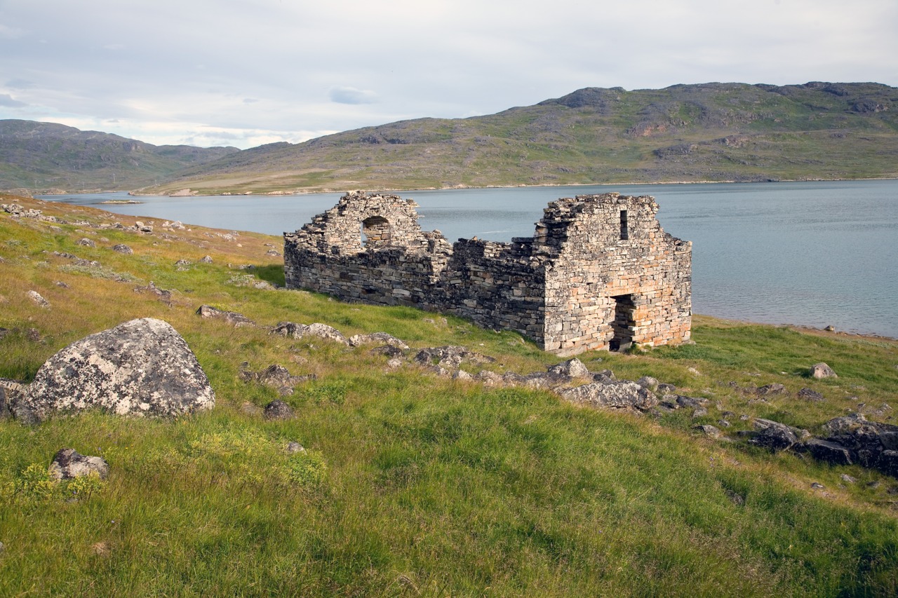
Hvalsey Church, Eastern Settlement, Greenland
Colonization is recreation. It features on board and computer games, from Simcity to Civilization, and from Settlers of Catan to Musk at Mars (ok, that one is apparently not a game). The games invite us to imagine a fresh start in a place where the past does not matter and where everything is a new adventure. It is to boldly go where no one has gone before. But it is harder than it seems. Our real lives are complex. We are dependent on interactions with others, and on products and services created by other people in different locations. We are not an island, and complete self-sufficiency comes at a high price. It brings fragility. And when things go wrong, help is hard to get.
Complete disappearance of a colony is rare. But it has happened. This post is about one such disappearance, one that shocked the world. It took 300 years for the remains of the colony to be found: some ruined farms and a roofless church. All traces of the cause of the failure had gone. Why did the Viking settlements of Greenland collapse? Was a volcano involved?
Viking settlers
Iceland was not an easy place for colonization. Still the Vikings went for it in their search for pasture. Getting there from Norway took about 10 days, a long journey in an open boat but doable for experienced sailors during the summer season. The migrants kept coming; over the next 60 years the population of Iceland grew to some 30,000 people. The migration declined when all good farmland had been taken. Eldgja (939 AD) finally put an end to this era of settlement.
But for some, Iceland had already become too crowded; it was no longer the land of opportunity. And so Vikings moved on from Iceland to Greenland and turned it into the most isolated European colony in the world.
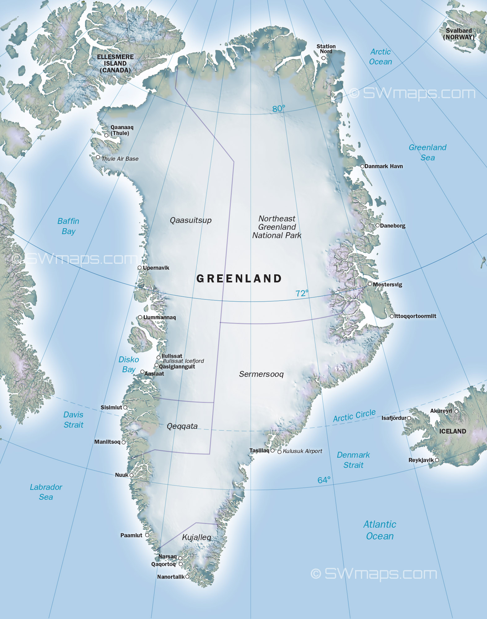
This was a surprising move. Greenland has the reputation of being a glaciated, uninhabitable wasteland. The glaciers are kilometers thick and cover almost all of the country. In the north and east the glaciers reach the coast. It is not an obvious place to start a dairy farm. But the west coast is different, and the climate is only a little colder than that of north Iceland. The southern tip of Greenland is further from the pole than Iceland and the sun and the wind from the high glaciers can bring some unexpected warmth. There are meadows here, along the deep fjords, and there are animals which call it home. Caribou roam the region. Greenland really can be green, in the right place at the right time. But the winters are long and the summers brief.
Eirik the Red (a colourful character) discovered the habitable regions on the southwest coast around 982 AD, only a few decades after Eldgja. He had been exiled from Iceland for bad behaviour (and that said something). Eirik decided to make it home, and starting his own settlement here. This required finding more would-be colonists. He called it ‘Greenland’ to make it sound more attractive, in order to entice people in Iceland to come with him to a new and empty world. The origin of the name was soon forgotten. Adam of Bremen, in 1072, wrote “The people there are green from the salt water, whence, too, that region gets its name. The people live in the same manner as the Icelanders except that they are fiercer and trouble seafarers by their piratical attacks.“ The people who made Greenland their home were as rough as the country they lived in.
Around 985 AD, 25 boats went on the migration, each carrying perhaps 30 to 40 people. Only 14 boats arrived: the remainder turned back before arrival, and some may have been lost at sea. Most of the around 500 people who came settled in a region just beyond the southern tip of Greenland. This was where Eirik had spend the three years of his banishment. It became known as the Eastern Settlement. (This unfortunate name caused serious problems later.) But 2 or 3 of the arriving boats moved on, and went further up the coast, 400 kilometers and another 6 days of travel away. This became the Western Settlement. These were the two main regions that were (somewhat) suitable for farming.
The first years must have been very hard. After the arduous and long journey, the settlers now had to set up home. Eirik and the people who had accompanied him in exile already had dwellings, but the others had to decide on a location, build houses, and hunt and farm enough food for the long winter, in just a few remaining weeks of summer. They managed, and over the next years more people came from Iceland to join them in their brave new world. The Eastern Settlement grew to 2000-3000 people; the Western Settlement may have homed 1000 people.

The Eastern Settlement in medieval Greenland. The known major farms and churches are identified, as well as some probable geographical names. Source: wikipedia
For centuries the settlements survived and even prospered. But it did not last. After four centuries, contact with Norway and Iceland was lost, and when people came to look for them the settlements could not be found. The rescuers were confused by the name, and searched for the lost tribes on the wrong side of Greenland, the ice-covered east coast. The search for the lost Greenland Vikings became legendary.
It took more than 300 years before the location of the two settlements was finally found. But there were only ruins, and they showed very little evidence of what had happened to the people. The discussions continue to this day. Some blame the worsening climate of the middle ages. Others give the cause as ecocide, with depletion of the local farming land and fishing grounds. English pirates have been blamed, or wars with the Inuit population. Speculation is rife and facts are few. The failure of the Greenland Vikings does not bode well for Musk on Mars, and it is important that we understand how isolation can lead to fragility, and finally to disappearance. It turns out that there were two extinction events. Were the triggers volcanic?
Greenland economics
Vikings were farmers. This is of course not what they are remembered for, but the looting, murdering, piracy and conquering much of the known world was a bit of a sideline to making ends meet. Farming in Norway was hit-and-miss, and when things went wrong or a new generation grew too numerous for the carrying capacity of the land, a bit of piracy seemed a good way to supplement one’s income, and perhaps reduce the overpopulation. When the Vikings moved to Iceland, they took their farm animals and culture with them. Norway has a cold climate and their way of life was suitable to the Icelandic climate. When moving to Greenland, they again did the same thing. The boats had carried not only the settlers but also their cows, sheep, goats and pigs. And all lived on a small open boat in difficult seas for weeks. Just imagine the smell!
The Greenland settlers never build towns. Instead they build farms of a variety of sizes, ranging from single family dwellings to large manors which supported tens of people. Some outlying buildings were occupied only in summer. The farms were typically 1 to 5 kilometers apart. You do get the impression that the Vikings needed their distance from each other! The Western settlement consisted of perhaps 90 farms; the Eastern settlement was a few times larger. The farms were located along extensive and multi-armed fjord systems. Each of the settlements extended over 100 km! The farms were mostly located quite far in-land where the climate was a bit better suited to farming. This is a second reason why the search parties took 300 years to locate the ruins. They were looking along the coast, while the farms were mostly in-land.

A typical area around the Eastern Settlement
There is a limit to what farming is possible in Greenland, and in the Western Settlement this was even more restricted than in the milder climate of the Eastern Settlement. Grain would not grow and bread did not exist. Some root vegetables were grown. Iceland is fertilized by frequent volcanic ash. Greenland is not, and it is ancient rock. Glaciers have scraped the ground down to the bedrock, and around the Eastern Settlement this bedrock is a staggering 3.6 billion years old! It has long lost any fertility it may have had. The farms were completely dependent on what patches of soil there were. They were dairy farms with a small herd of cows providing milk. All suitable soil was used to grow the hay that was needed to keep the cattle alive during the long winters. Poorer fields were used for sheep. The hay was supplemented with anything else they could get, including some seaweed. The cows stayed inside (in the houses!) for 5 months (Eastern Settlement) to 7 months (Western Settlement). The calves were born here. At the end of the winter, sometimes they had to be carried outside, being too weak to walk. In autumn, famers would need to decide how many cows they could keep through the winter.

Reconstruction of a Viking long house. Source: Erik Painter
Hunting supplemented the meat. Caribou meat was especially valued. Seal meat was eaten when caribou was not available, but was not the preferred meat: the manors mostly ate caribou, the poorer farms ate seals. Fish was taken from the rivers and lakes, but not from the open sea. The Greenland Vikings (unlike those at Iceland) used no nets or harpoons, only hooks. Seals were hunted in the spring on their breeding ground on the shore.
The big attraction of living in Greenland, though, was something entirely different. Walrus tusks were highly valued for their ivory, and this became Greenland’s dominant export product. Iceland’s supply of walruses had been quickly exterminated. Greenland had unlimited numbers. Their ivory made Greenland economically viable. The walruses were hunted at Disko Bay, 300 kilometers north of the Western Settlement. Hunting parties from both settlements would go there. Disko Bay was perhaps the reason why the Western Settlement had been build in such a marginal location. Not only could the people here travel to the walruses much quicker, they could also set off earlier in the season. Drift ice from East Greenland could block the fjords of the Eastern Settlements until June, whilst the Western Settlement had much less drift ice: they could go to Disko Bay as early as April. Within a century of Eirik the Red, all ivory in Europe came from Greenland.
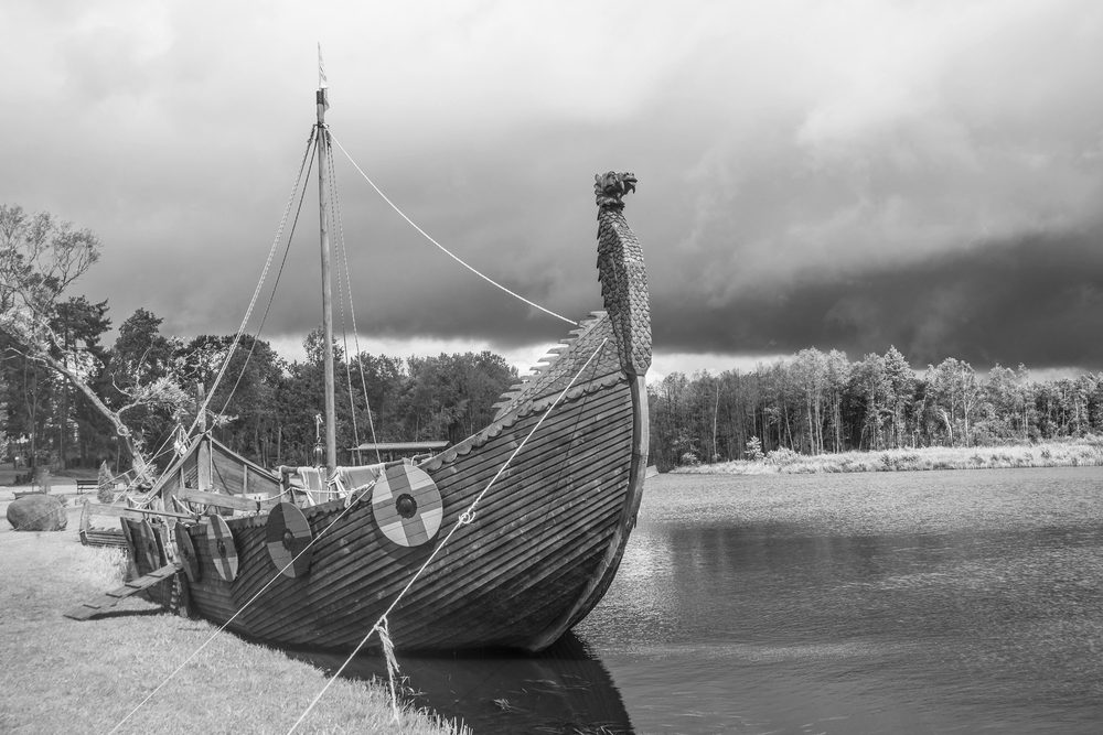
A Viking long boat
Because of the shortage of wood, Greenland eventually lacked the boats needed to trade their ivory themselves. They depended on visiting traders. In later years, one Greenland boat which managed to reach Iceland caused a bit of a sensation, by being so small and because it lacked an anchor. That was a second lack: Greenland had no iron.

Newfoundland
The journey of the Vikings did not end in Greenland. A bigger prize was beckoning, and it became important in filling the gaps in Greenland’s economy: America.
There are two versions of the discovery of America. I will follow the Greenland saga which seems the more likely one. One of the original settlers of Greenland was called Herjolfr. He had left Iceland while his son Bjarni Herjofsson, was away in Norway. Bjarni went looking for his father, but wasn’t sure where this Greenland was. Driven too far west in a storm, he sighted a land with trees and mountains. This clearly wasn’t Greenland, and Bjarni backtracked to continue his search, without stopping. He managed to eventually find Greenland, and remained there with his father. After his father’s death Bjarni returned to Norway. The land he found sounded rather enticing, and when Bjarni left, Eirik’s son Leif bought Bjarni’s boat and went looking for this land. (This already indicates a lack of sufficiently large boats in Greenland.) Eirik himself stayed behind in Greenland. This happened around the year 1000.
The new land improved as Leif’s party sailed south along the coast. They gave it descriptive names: the northern area including Baffin Island was called ‘Helluland’ (slab land), south of about 60 degrees latitude it was ‘Mark land’ (forest land), and further south (Nova Scotia and perhaps around the St Lawrence river) they called ‘Vinland’ (wine land). Slab land had little to offer apart from foxes, and the winters here were much more severe (and snowy) than in their Greenland homes. Forest, though, was a very valuable find and grapes would have been out of this world for a people having neither wine nor beer. The party wintered in Newfoundland, and returned to Greenland the next year with their new-found treasures.
After this the story becomes vague. A settlement was started in the new land, from where they would travel south. This settlement was discovered at L’Anse-aux-Meadows, at the northern tip of Newfoundland. There may have been a second camp further south. Women joined the party, and a Viking child (‘Snorri’) is said to have been born in North America. Archaeology has shown that the people at L’Anse-aux-Meadown included Icelanders – it was not a purely Greenland exploration. The child was said to have ended up back in Iceland. There may still be people in Iceland with a North American link in their ancestry!

The big house at L’Anse aux Meadows. The entryway is in front, the sleeping quarters in the center. To the left a boat repair area, and to the right storage. Source: wikipedia
The travels to Newfoundland had a clear economic benefit. The Vikings needed wood for their boats and their houses, and there were trees at L’Anse-aux-Meadows. Iron too could be obtained from this region. There was also hunting, but the winters at L’Anse-aux-Meadows were quite severe (more so than at their homes in Greenland) and the game was scarce. This is one reason why there may have another camp further south. Around 100 people would have stayed at L’Anse-aux-Meadows.
How long the settlement lasted is not well known. The sagas talk about the conflicts with the local population, and also about murder in their own ranks. It appears that the site was abandoned within a century, perhaps even within a few decades. After that, Vinland was out of reach for the Vikings. But summer journeys to Newfoundland (or Markland) continued long after. Even at late times in the Greenland settlements, their boats and coffins contained larch wood which only grows there.
Why did the American settlement fail? In the end, they lacked the numbers to grow into a viable colony and to defend themselves against the local population. Greenland was settled by about 1 in 20 of the Icelandic population. L’Anse aux Meadows housed about 1 in 20 of Greenland’s population. Greenland was perhaps just too small to support another colony. If Eirik the Red had gone a bit further on his first attempt, straight for North America, a viable colony might have been possible and history could have been very different. But he didn’t.
Decline
The two Greenland settlements did well for centuries. These were not marginal societies. Farmers were never wealthy, but they made a living and ivory provided income. Churches were build and even stained-glass windows were imported. But over time, cracks were showing. The lucrative trade in ivory remained important until around 1300. But after that it declined. In part this was because other sources of ivory had become available, but a more important reason was Norwegian politics. In 1294, the Norwegian king decreed that all trade had to be done on the Norwegian royal vessel. The aim was to make sure that taxes were paid, but it severely limited trade and import. The vessel came irregularly. It also never went to the Western Settlement, because adding this trip to the journey would have required the vessel to overwinter in Greenland. The Western Settlement had to bring their taxes (paid in kind, with ivory and walrus skins) to the Eastern Settlement and received little or nothing in return. In comparison, the Eastern Settlement still did well enough to build a small cathedral.
By the middle of the 14th century, trade with Greenland had diminished so much that in Europe ivory became in short supply. This reflects the lack of shipping opportunities. It became even worse during the years of the Black Death when few ships sailed the North Atlantic. (One visiting bishop in Iceland was stuck for four years because no ship came for him.) The Norwegian royal vessel was itself lost in 1367 and after that there was little contact between Norway and Greenland. A consequence of the diminishing trade was that the Black Death never made it to Greenland. It did get to Iceland, though with 50 years delay.
In the absence of trade, we do not know whether the hunts at Disko Bay still continued. The contacts between the Eastern and the Western Settlements had been decreasing. Travel between the two took 6 days, and was only possible in summer when there was much else to do. After a while, the only recorded visits were to pay taxes. The last such record was in 1327.
The Eastern Settlement also became isolated. The last documented visit by people from Iceland was in 1406-1410, with circumstantial (and unconvincing) evidence that the same people returned in 1418-1420. After that the Greenland Vikings were never seen again, at least by people which documented the visit. This was the time that European fishermen began to frequent the Newfoundland region for cod. New designs for boats had improved speed of travel, and now it was possible for the fishermen to make the journey within one summer. Before that, they would have had to winter. There may have been contact between the fishermen (mainly from the Basque region and from Bristol) but this is speculation.
In 1410 all had been well with the Eastern Settlement. But within decades it would be gone. Archaelogical evidence shows that the best farms reverted to wild meadows around 1450. At the very least this means there were no longer any cows, and at the worst it means there were no longer any farmers and the last true Vikings were gone.
It took many years for the disappearance of Greenlanders to be noticed. After 1500 even the pope expressed concern, and expeditions were planned to find them. But by that time the location of the settlement had been forgotten. People searched the east coast, opposite Iceland, being confused by the name ‘Eastern Settlement’. But this coast is unreachable due to ice. John Davis visited the western coast several times around 1585 while searching for the northwestern passage but he did not find anyone. The settlement was rather far from the coast, of course, and would not have been visible from the sea. The Eastern Settlement was found only when a Norwegian missionary, Egede, spend a winter on the coast, barely survived, and decided to move further in-land. He traveled widely in the area, and his Inuit guides showed him the remains of the Eastern Settlement, including the roofless church of Hvalsey. This was in 1723, almost 300 years after the failure of the colony. Egede, and others after him, thought this was the Western Settlement and that the Eastern Settlement would be on the east coast. This expectation was only disproven in the late 1800’s. The North American settlement at L’Anse aux Meadows was found only in 1960. It really is possible for nations to be fully lost.
Archaeology has shown that the decline of the Eastern Settlement had happened over many years. The outlying farms were abandoned first and people moved closer to the better ones, perhaps in servitude. The abandoned farms were carefully demolished to save the timber – remember that wood was a precious commodity in a place without trees. That already shows it was a managed decline. It is even possible that people slowly migrated back to Europe when the British and Basque fishing vessels began to frequent the area. In any case, by 1500 and perhaps already by 1450, none were left.
The fate of the Western Settlement was different. It had ceased to exist much earlier, and so suddenly that not even the Eastern Settlement ever found out what had happened. A settlement that had existed and flourished for 350 years had been wiped out by a disaster. Was a volcano to blame?
Part II: demise of the the Eastern Settlement
Albert, June 2021


I have been carefully watching the last half hour and the lava is getting hotter, turning into a white-yellow color gradually all along the stream. See https://www.youtube.com/watch?v=XwN-u4Ccygs and I also see some type of flow upon the main lava field trying to make its way over to the west overflowed dam. Maybe the lava will cut a direct route from the cone down to the Natthagi valley? (timestamp 21:55 pm 5-June-2021)
The flow did break out directly from the pond just under the cone, so having a feed that now bypasses the rest of the system is a possibility.
It is incredible the eruption is getting stronger, I think it is the dike being eroded, or rather now the conduit, it is clearly much more open than it was earlier on, and the more lava that flows through the greater the heat and erosion rates become… The hell machine is turned on, it is possible this thing will get pretty insane just before it ends, an exponential increase until the magma chamber is empty.
I would like to know if very broad slight deflation is observed around the Reykjanes area to indicate a magma chamber deflating deep down in the mantle. If that is actually not observed then this thing is going to be gigantic, like nothing we have ever seen.
Is there an updated lava composition? That might give more info on the source.
Apparently it is even more primitive than it was before, nearly ultramafic.
Spectacular. But. The authorities might want to start thinking more than road. The completely unpredictable lava routes suggest other future outcomes should be considered. Thinking about a northern – north western exit. The volume of the pulse seem to be increasing given the over topping of the very high walls. I remain completely addicted to watching this mesmerizing display of the earths power.
I cannot update any of the brunnur.vedur webcams, I get an error message. Anyone else? Aaarrrgghhh…
Same!
A lot of the cams are “forbidden” to me at the moment… 🙁
Same here. The 1 minute timelapse plus the activity probably broken the system. Maybe come back at 00.00
3 nice youtube lives anyway.
403 this morning, probably too many people outside of Iceland are looking for this connection and as it is for the safety of Icelanders and not for the enjoyment of viewers in the rest of the world.
That leaves the webcams.
And no coverage of Meradalir…
The vent appears to have suffered a major wall collapse right around the rim? Lava seems to be pouring continuously from it.
I see the Icelandic police are determined to arrest the flow of lava into Natthalgi Valley….
Maybe since the West Dam overflowed, they think that the Law would stand taller?
🙂
(Glad to see the Boulder is still with us!)
Oh the boulder will be around much longer now!
Once it is nicely covered with fresh lava it’ll be better equipped to survive the weather, climbing tourist, or even the next ice age. It will take a much longer time for erosion to break the boulder down into sand and pebbles, if it is encased in fresh rock cover.
I saw two walkers passed the main cam viewing the current overflow. Perhaps more people now will view from the cam hill -if it’s good enough for a cam ,it’s good enough to view from.Thus it may become Theatre II hill.
Balcony….. just saying…
Superb overview of the western wall breach in this highly recommended Gut n’ Tog youtube:
https://www.youtube.com/watch?v=KiPNFaYrmTM
Substantial channelized flow from the east side of the dam, yes, but it looks like tubes from overtopped areas all along the dam are contributing to massive flows heading down into Natthagi. The collected flow front is impressive. I am no expert, but am estimating a flow width of ~3m, depth of ~1m, and speed of ~5m/sec yielding ~15m^3/sec. If true, this means most of the active vent is draining through this single flow. Love to hear more experienced views on this!
It could make sense.
Lava flowing over the saddle draining the areas east of Theater Hill coupled with what appears to be renewed channelization from the vent running just west of Theater Hill are coming together at a single point. The hydraulic head must be enormous, and the previously (relatively) sequestered lava now has somewhere to go. The bathtub plug got pulled, yes?
PS – estimates I gave came from observations of the single channelized flow at about 2:20 into the video.
Not sure on exact numbers, but it does fit with my observation that nearly all of the visible flow is to this area. The channel broke out or started right near the spillway from the vent, so unlike most of the other flows it has the potential to capture it all. It looks right now to actually be forming another perched pond right above Natthagi, that is worrying if it breaks, no wall will ever stop that.
It looks like this pond is itself also forming over the impounded flows behind the dam, only a few weeks old these will still be liquid. The dam has delayed the inevitable but may have made the situation much more hazardous, if it all rushes out we will get a flow that is of flood basalt magnitude, in Hawaii these breakout flows several times in the 2000s flowed as far as 7 km from the origin in a few hours.
Thanks for very interesting reading how failing trade and economics/politics ended the Greenland colonisation. Missing the climate angle. As I understood from other readings, the climate cooled gradualy during a couple of hundred years and impaired agriculture and trade to the point of impossible. Is that just a speculation? Maybe you hinted at something with your volcano question?
Maybe we will find out in part 2. I shan’t say any more till then…
The Norse colonies in Greenland starved and vanished by the early 15th century, as crops failed and livestock could not be maintained through increasingly harsh winters. Greenland was largely cut off by ice from 1410 to the 1720s.
https://en.wikipedia.org/wiki/Little_Ice_Age#Europe
https://en.wikipedia.org/wiki/The_Hunters_in_the_Snow
A volcano on deserted islands like the Azores or Galapagos could be among the suspects.
Well, as of 6am GMT the boulder is still there, the flow must be onto the thickening stage, repeating its behaviour once again.
New fantastic videas from GutnTog, e.g. this one:
– https://youtu.be/KiPNFaYrmTM
Gutn Tog has excelled again, he visited the site yesterday evening.
https://youtu.be/3h5YP3w2Xdc – he taks about the boulder being covered, but it’s not yet happened.
https://youtu.be/_roLXkXl7Jc – panoramas from the new viewing point over Geldingadalir and the old Theatre Hill cut-off flow.
Now it is…
https://youtu.be/XwN-u4Ccygs
https://youtu.be/hGKbtx0UEs8
Time-lapse of Nàtthagi from Tokolosh
https://youtu.be/Ug_SjUBsSz0 – Gutn Tog takes the muffler off to record the sound of pahoehoe flowing down into Nàtthagi.
https://youtu.be/tiaZajCMH5E – speed of flow.
A large amount of fresh lava seems to have gone over the Eastern dam this morning. Something else to look out for today
big on Natthagi webcam now
Yes this third river just arrived the the valley… beautifull!
Are the weather gods conspiring? Misty conditions thickening as lava surrounds the boulder.
Chat on one webcam feed indicates the fountaining events are further apart. Possibly related to easing of pressure by the new lower opening at the base of the cascade?
There is a new lava fall on the hill on the right. It is falling fast
It broke out at 7:55:40 and reached the bottom 2.5 minutes later
It’s a gusher. Wow.
I’m glad that person walking away on the track turned around in time to see it still falling!
And there’s a brand new lavafall down from the eastern breached berm, double flow.
à third flow now…
I would not be surprised, if in the next update the output Volume wurde be 15 till 18 m3/s.
The eruption lasted roughly only 90s, but there is a huge amount of Lava gushing out. WOW !!!!
https://www.youtube.com/watch?v=I1I-0PUhFmU
And the new flow on the eastern wall is big and fast………
New flow is moving very quick, gone at least 500 meters in maybe 10 minutes,
Make that nearly 1 km, thing is advancing as fast as you can run.
On https://www.youtube.com/watch?v=BA-9QzIcr3c you can see the lava in the old Geldingadalur at the top left, to the left of theatre-hill-II. It is is hard to judge how far it has to rise to cascade into Natthagi from there. If it does, it will turn Hill-2 also into an island
It will also trap what I assume is an expensive bulldozer, if they fail to move it in time,
This cone more and more shy. Push away visitors. 🙂 I was just looking at maps and dont need so much to cut off teather hill II class.
New earthquake swarm around the Salton Sea (California).
Almost identical location as the swarm (>200 quakes) of 2016.
Hmmm, gotta wonder if something is trying to let loose…but being purely transform/strikeslip at this location, it’s probably just a weak spot along the fault that can’t hold much stress.
The Kilauea raid expansion is continuing. last time this happened at this rate, the eruption followed within 3 weeks. I can’t keep up with all this activity
I have trouble keeping up with the comments…
Carl said all the volcanic activity was cancelled because of Covid last year.
So now we have all last years eruptions added to this years.
I was expecting this. LOL’s
Spoiled for choice, another eruption in Iceland soon perhaps! Just like busses none for ages than loads arrive at once…
I wonder are the Iceland authority’s going to move those bulldozers soon, the speed things are moving they could well get marooned.
Being realistic I dont think it was ever likely to be a long gap, the GPS had been going up ever since the north vent failed. That suggests the magma influx has always been higher than the effusion rate of the west vent. Or there is a lot more magma than expected.
It seems strange to lower Kilauea to yellow, it should still be orange, and Mauna Loa should be green.
I feel so sorry for that lonely person walking away at that critical time… forever memorialised in a huge vocanochaser fail…
Having looked over the contour maps on map.is where you can draw in lines and see the height differences on said line. It seems rather likely that we’ll in the near future see another lavafall roughly where I’ve drawn on this image
If you look at the top right of your screenshot just before the lava flow along the edge of theatre hill reaches the incoming saddle lava, the flow does a sharp turn East.
The incoming saddle lava has diverted yesterdays flow from the West dam to the East dam. It started happening late last night before I went to bed. You’ll be able to pick it up on a timelapse today I’m sure.
At present not much is going over the West dam.
Lava is running down both the west and east channels. Think the camera angle just makes it easier to see the lava pond on the east side.
There’s a lot of lava going into the system, judging by the enthusiasm with which it cascades out of the crater.
Source for image: https://www.youtube.com/watch?v=BA-9QzIcr3c
https://www.youtube.com/watch?v=XwN-u4Ccygs
The glacial erratic is just about to be consumed so is the rest of the dew pond by the looks of things.
This webcam has a great view of the lava falls.
The cone is really white now, makes me think of snow or perlite(I work at a plant nursery, you get environmentally damaged by your job I guess)
Smooth shiney pahoehoe is why its light grey. Inside is a lava lake that churn and swell and hiss like an uneasy python snake
Regarding Nyirangongo volcano…
2021-06-05: The seismic data, recorded today, indicate little change from the situation on June 3rd. The GPS network did not detect any displacement at the stations today.
https://georiska.africamuseum.be/en/news/nyiragongo_eruption
Grimsvotn must be close by now surely, I remember an article not so long back that predicted May 2021.
I think it will erupt through fissures again rather than through the main vent.
A long timelapse from yesterday afternoon to this morning from the Langihryggur camera view.
The dam collapses/overflows and after that the lava races down, the camera view changes to a better view as well.
https://youtu.be/Yvt9F9_-zdQ
Beautiful to see the slow diversion to the east wall, resulting into a nice eastern lavafall into Natthagi
Thanks for that. Very absorbing catching up on what happened after I headed for bed last night.
https://www.youtube.com/watch?v=BA-9QzIcr3c
Zoomed in on the fast lava fall.
That is quick.
This was the crater when I flew over this morning
And the white / gray color means very fluent lava, right?
Yes its very hot and Liquid .. that forms a smooth glassy surface.. that reflect light.. just like the Hawaiian lava flows. Fagradalshraun is very very fluid and looks like liquid aluminium close to the vent: hottest lava ever seen in Iceland so far by modern cameras
nice! what kind of drone? will a dji mini 2 be useful, or is there too much wind?
And a different view of everything
Wow…thanks for this one – what a perspective!
🙂
Reminding of:

New attempt:
https://de.wikipedia.org/wiki/Der_Wanderer_über_dem_Nebelmeer
Mt. Hood is also having a coughing fit. So far nothing indicating volcanic movement
https://www.usgs.gov/center-news/m39-earthquake-and-swarm-occur-mount-hood-june-5-2021
Extremely beautiful, thank you!
Tune in now!
New lavafall incoming on the far right
The boulder is still there!
The next lavafall is imminent, it is creeping towards the edge
Do your contour maps give any indication where the lava goes if and when it exits the South end of Geldingadalir?
Its exit height is meant to be 228m similar to the saddle into S Meradalir.
Most say it heads into Natthagi just above the mud pool but I don’t think that is in any way certain.and it could head towards Natthagakriki
I looked at that a month ago. It seemed liklier to go to Natthagi, but I couldn’t be sure. The difference is too small.
Just stumbled onto this video. It offers a clue
https://www.bing.com/videos/search?q=gutntog+youtube+geldingadalir+lava+close+to+spill+over&docid=13839366171698&mid=F467C3EC0648CA4365AEF467C3EC0648CA4365AE&view=detail&FORM=VIRE
After having made lots of measurments and dots and whatnot, I’d say it is most likely to head into Natthagi. Also made a line showing the path of least resistance here in red. That being said, the plateau circled in red, is almost flat, so my guess is that it will first go into Natthagi, and then a spillover event or similar will go into Natthagakriki (black arrow), but I wouldn’t say it is 100% that it goes into Natthagi first, as we are talking very small height differences to begin with.
Thanks Bjarki. Very useful.
I think this is where you mean, this will, at some point flow into the valley with the other flows :
Not one of my best shots, but I think it should help
When was the image taken, 67doug?
@Merlot, that shot was about 12:30 (Iceland time) today
Seems to have a bit of a climb still before it overflows (1 – 2m?). The path may be the easiest route to take 🙂
One can alsolook at this video from GutnTog:
– https://youtu.be/XbpSbeDiKlM
He follows the lowest path into Natthagi.
He says 5m for the lava before it can go over into Nátthagi.
Lava is now visible in the top right corner
https://www.youtube.com/watch?v=XwN-u4Ccygs shows that this new trail is now being followed (23:13 pm timestamp)
During the night there was a small stream of lava that made it halfway down, but failed to establish a new flow.
Having watched one of the webcams for the last hour or two, there now seems to be very little fountaining, and each cycle there is just a little overspill from the cone. Is this indicative of
a) The eruption subsiding
b) A different perspective from a different webcam
c) The lava now making its way out via ‘tubes’
d) A change in the characteristics of the eruption
Or perhaps a combination of several of the above?
I would say that the air-lock in the outlet now is almost straightened out. The fountains have gose smaller and smaller, but the effused volumes seems to have increased. Lava is now flowing freely from the mantle to the surroundings of the cone.
I tend to agree with your assessment, but do we have recent data on the flow rate? It does seem to have increased slightly again.
it was showing as 12.4m3 when I saw it this afternoon
Have they made any recent measurements?
Definitely not 1, a combination of all of the others.
Direct mantle eruptions are rare, when they do happen they are large. I have brought up Lanzarote, as has Hector, that was 5 km3 of lava flooding out of the ground seemingly to no end for 6 years.
Thing is too, a conduit like this doesnt easily close and indeed the evidence is that the conduit is getting bigger, so even if this exact vent stops another one will take its place, which also happened at Lanzarote. This already sort of happened in April with more vents opening, but it can happen on a larger scale too, and likely will if the effusion rate increases significantly for a long time.
Iceland is also a WAY more powerful mantle source than canaries ever is .. so I see so
Much more potential too here.
One small comment on the article: “Vin” in this context is a meadow, or farmable land, not the drink. In modern Norwegian “vin” is wine, but the Norse “vin” lives on in many old place names.
This has been argued in various places, and of course it is always hard to be sure. The sagas specifically refer to grapes, though. You may of course get grapes from meadows
Another lava flow is starting…
Since the lava ‘pond’ collapsed, I would expect to see more flows. The output from the main vent looks to be a constant 12.4m3. The pulses/surges seem to have no impact.
This is certainly a fun eruption to follow.
I will be trekking the lava flows tomorrow, it’s going to be interesting to see which will be the best to follow. (the weather also looks like it should be better)
Earthquake swarm under Mount Hood volcano, Oregon
Yes, 50 quakes now last 24 hours.. not too far from me. I don’t like the idea of magma mixing, in this particular volcano.
I cite this paper https://ui.adsabs.harvard.edu/abs/2010AGUFM.V43C2387K/abstract as a look at magma mixing at Mt Hood.
Not too far from me, either. However, I think these may be on the faults just south of the Mountain(?).
Seems to occur once or twice every year, typically surrounding snow melts or heavy rains. Looks like it’s roughly centered in the White river canyon, below the glacier, in between Timberline and Meadows ski areas. I’m not seeing anything that raises my angst yet.
https://www.pnsn.org/volcanoes/mount-hood
Geologist Steve Malone writes about the Mt Hood earthquake swarms https://pnsn.org/blog/2019/07/09/typical-mount-hood-earthquake-swarm as these seem typical of Mt Hood, but I am not sure when a 3.9 quake last occurred in a swarming episode.
IIRC: I think there is a well known active fault in that area,
USGS is on it.
https://www.usgs.gov/center-news/m39-earthquake-and-swarm-occur-mount-hood-june-5-2021
Earthquake locations from USGS. 51 eqs shown, most have depths between 3 and 6 km, with one at 0.1km (in blue).
]
Source for image: https://earthquake.usgs.gov/earthquakes
As a dumbo non-volcanologist, it nonetheless bothers me that the Mt. Hood earthquake sequences are around to 5-6 mile depth. That’s nicely around a magma chamber, and the earthquake location chart from the USGS all but confirms it.
My personal take is that we’re seeing re-pressurising of the existing magma chambers, possibly including melt of crystallized mush, and the start of upward mobilisation.
It may take some years, but I feel we have an awakening volcano.
Yeap,it’s 2021 after all- Hood will do it’s thing sooner or later!
I presume the absence of the Icelandic Met Office cam pictures is bandwidth-related? They are very high-definition pictures (at 100% on my browser only a fraction of the photo is visible) and a day’s worth load at a time in order that you can run through them in quasi video mode.
Are they still available to people in Iceland? If so perhaps people could copy and post any good ones – must say I’m missing the Meradalur view. Postimages is a free picture host that doesn’t require login, better IMHO than imgur.
I agree, their bandwidth for the download of ALL the hirez pix, will have been excessive.
It ought to be possible for them to at least post the current image, reduced to 1080p, even if they do not post the sequence. Certainly the image size, whilst typical of a stills camera resolution, is unnecessarily big for general use.
It certainly helps Icelandic PR.
Stunning fluid lava on the Visir cam.
https://www.visir.is/sjonvarp/beint
I was watching that; the colours were outstanding.
Visir might start planning to move the webcam uphill.
And just now, there’s a new channelled flow wandering out of sight from the constant side overspilling.
I saw that one as well. Note also that the cone soon (a few days) has the same height on all sides which will increase spill into Geldingadalir even further.
And this now happens with every over spilling on the “back side”. The spill is quite massive with every new pulse now…
what else to bring for a 4 day volcano visit, staying in Grindavik?
tent, sleeping bag, sleeping mat, pillow, camping stove, cookset, full frame camera, lenses, tripod, compact camera, camera batteries, battery charger, action cam, small tripod, batteries, drone, batteries, charger, hiking boots, rain gear, gaiters, hat, gloves, clothing, toiletry, sensor & lens cleaning stuff, sit pad, phone, powerbank, charger, food, tea, whisky, microphone, deadcat, hiking sticks, gas mask (ABEK1HG), helmet, sausages, marshmallows, rental car
A large sum of money?
Also modern compact and semi compact cameras are astonishingly good, c/w stabilisation and small, light and cheap. 30x opticals are quite small and even a 128x is not absurdly heavy, tripod still required.
https://www.cameralabs.com/nikon-coolpix-p1000-review/
no, not a large sum of money, the deadcat is on order, all other stuff is stuff I already have and use for other activities (except the gas mask).
I was thinking of food and drink etc. Iceland was notoriously expensive.
Big heavy expensive cameras possibly not ideal was my thought.
I am actually not sure which tele lens to bring – the 70-200 or the 300, both could be used with 1,4x and 2x tele converters.
I have found the tripod to be more important than the lens! Which may just show my limited skills at photography.. Light levels in Iceland are not high.
Indeed even for stabilised cameras with modest zoom (eg 12x), and definitely in low light levels. The samsung (x12) I use for holidays seems a decent mix and the stabiliser on dual mode is really impressive. It has what I assume is a very grainy multi-snapshot for long (I guess 500ms) exposures which it then seems to overlay and merge to give very sharp pix in poor light levels at high zoom. Good for internal details. For very low light shots (many secs) its impossible without a tripod or wedging the camera into position and using a delay to prevent shutter release shake.
Modern cameras are truly amazing.
I will definitely bring tripods (a big one, and two very small ones)
Either a waterproof camera (I’ve just bought a Fujifilm XP140 which is not very expensive at £140 and is waterproof to 25 metres) or a very good waterproof bag.
Imagine two or three hours walking, a couple of hours watching, and the walk back in some of the conditions we’ve seen. When you only have a few days you may have to take the weather as it is. Lovely this morning!
If you have the money the Olympus TG6 is waterproof and very good.
I use a raincover on my backpack and my cameras are quite weather resistant, no problems with my then Nikon D200 when hiking the Laugavegur trail in Iceland in 2009, and the RX100 proved itself on hikes in Corsica, Wales, Ireland and at home. The Z6 is quite rainproof, it get’s wet a lot.
yes, weather is a big concern, but it is so changeable in Iceland that you just have to deal with it!
Yes I have an earlier version. Great for underwater shots (needs some post processing though) or for taking into wet areas like rainforest or on boats. It has a basic double catch and this is worth it as in Belize on the reef two people with waterproof cameras (I think Panasonics) managed to unclip the battery compartment and trash their cameras.
The were not much comforted when I pointed out that at least the flash card was 100% waterproof and their existing pics should be OK.
PS They are not indestructible if you hit them with big rocks,
Warm clothes and then more warm clothes.
my 4th trip to Iceland (1992, 2009, 2017) slept in tents every time – I am quite aware of the weather, I will pack enough.
See you there Friday evening, hopefully! And Saturday too, maybe Sunday as well. We will also be on a 4 day visit, of which Day 1 will be waiting for a mandatory test result to arrive, unless that has changed very recently.
Hate you both.
Hate you both.
Hate you both.
I am not jealous.
I am not jealous.
Ok, maybe a bit….
we would rather be in Oz to be honest, but our flight last year was cancelled at 3 days notice when they shut down. Hoping to get there in 2022!
my trip will start only on June 30th – I hope the volcano is still active then!
Vaccine passport?
yes, this is the main reason I am only able to travel now.
A big smile? I am looking forward to your reports!
even though the trip starts only at June 30th I already smile when I think of it!
https://sketchfab.com/3d-models/fagradalsfjall-volcanic-eruption-02062021-3dc09c0d15ff4ef881d4480b7c9819ac
Look at the southern outlet from Geldingadalir, there is not much difference between outlet to the SW and to the SE (Natthagi). It looked like the difference was a bit larger in the GutnTog video (towards Natthagi) though.
Popcorn
hmm, is microwave popcorn ok? And then, throw it at the Lava?
My wish, and I’m sure others, has been granted. A new close up camera on theatre hill 🙂
The green stuff, are those sulfur deposits? A lot of sulfur in that batch of lava in that case…
Or high olivine content possibly?
that is an amazing camera!
I wonder how many m3 is each burst. The mountain is overflowing for few seconds and it is quite amazing.
I just roughed out the calculation
50 sec long pulse. Avg 12.4 m^3 per sec. pulse every 9 minutes give a pulse only volume of about 134 cubic meters per sec. but much higher at max expulsion rate when the lake is at its highest
Is that perfect cone Keilir, in the distance on the far right?
Beautiful. The did zoom in .
Is the rusty-colored lump in the lower left of the frame what remains of the original twin cones?
Yes. Soon to be subsumed back into the lava field. I wonder if any will detach and Bob up to become lavabergs? (pun intended)
🙁 🙁 🙁
Pity….they gave us so much enjoyment over their time.
Laughing. Thank you.
Amazing! Thanks Boogah. It was my wish too to get a closer view.
The rapid extension in Kilauea has reverse itself, back to a slowly increasing baseline. That is the risk with using only a few days: it may not always show the trend. The same is true for the current reversal. The deep DI event may carry some blame for it. We need to wait another week!
That cursed DI event carries all the blame, I hate it when they break a nice inflation trend. Even so, lava does seem to be entering much faster Kilauea than it was in April, when the volcano looked almost dead. But I agree it would be best to wait a few days.
The shape is interesting though, its like a U shape on the deflation trend but then turns into a V shape as it leads out, like there is a continuous linear increase that is interrupted, something that was not seen earlier.
Safety valve kicks in during the inflation
I noticed on the GPS stations that the inflation is particularly strong along the ring fault, so much so that OUTL just south of that area is actually subsiding, while CRIM and AHUP are rising. It is a different signal, the next eruption might be on the ring fault.
Interesting a tivity under Grimsfjall this afternoon. Some magma movements?
Did the official smart people say why the lava is quickly turning whitish now?? Do the majority see any slowing of this eruption? Sorry i can’t be on here all the time… i miss a lot lately. And FarmerOz…. Your comments were the first thing i saw…. “What? the blog has gone absolutely ranting??” But i understand now. 😉
Gutn Tog said experts said was turning to white glass, Jesper says its just fresh pahoeoe, they are probably both right although to have lava that white suggests foamed/very thin lava to me.
PS Bet that’s what you thought too …
just for a microsecond or two….
Pahoehoe is glass, so both statements would stand for the same thing. Both right I’d say.
There is no slowing of the eruption. Fountains are low now simply because the conduit is wider and almost the entire crater fills up now before the gas bubbles burst. You get some splashing on the surface, but not the high focused jets. Last measurement of the lava output is 12.4m3/s.