I feel fascinated by volcanoes and I think that’s quite obvious, but there’s also room for other natural phenomena, like weather. In Spain, my home, volcanoes are rare. We do have a ~10,000-year-old monogenetic volcanic fissure in northern Spain, part of the Catalan Volcanic Field, a cluster of weak alkaline volcanic fields that have been episodically active for more than 10 million years. However, for the most part, volcanoes are not present in mainland Spain. I more directly experience other natural events like thunderstorms, but what I didn’t know until now is that the weather may have more volcanic in it than I thought. This year’s very anomalous weather in Spain might well be linked to a series of middle-latitude, northern hemisphere volcanic eruptions. And here I will explain why I think so. It all started in Kamchatka.

Map with the volcanoes discussed in the article.
The April 11, 2023, Shiveluch eruption.
Russia’s Kamchatka Peninsula is home to an impressive bunch of volcanoes. The Klyuchevskoy Group and Shiveluch in the Central Kamchatka Depression are probably the most productive stratovolcanoes on the planet. At the northern end of the volcanic arc, towering 3 km above the Central Kamchatka depression, lies Shiveluch volcano, a mainly andesitic volcanic edifice with a volume of 1000 km3 that started to form 80,000 years ago or earlier. A double, nested landslide headwall encloses an active lava dome that has grown since 1964. The volcano effuses viscous andesite lava more often than not. The effusions frequently collapse into pyroclastic flows. For a distance of 15 kilometers to the south of its lava dome the landscape is a volcanic desolation of ash and rock, created by debris avalanches and pyroclastic flows from this very restless volcano. Shiveluch is also a prodigious source of plinian eruptions, including a VEI 5 event in 1854, a VEI 4 in 1964, and the eruption that interests us, the VEI 4 of 2023.

Shiveluch volcano. NASA image taken fro the ISS.
On April 11, 2023, Sheveluch entered a plinian eruption. A massive cloud of ash and gas spread out from the volcano to heights of 20 km, mantling nearby towns in tephra. Pyroclastic flows traveled distances of 19 km. This was probably the largest volcanic explosion this year. I’ve seen various estimates of the amount of sulphur dioxide produced by the eruption ranging from 700,000 to 100,000 tonnes of SO2. Overall the values seem to move through loading typical of VEI 4 eruptions. Volcanic SO injected into the stratosphere reacts to form H2SO4, and it is known that this sulphuric acid can act as an aerosol that reflects sunlight back to space and cools the atmosphere. Generally, the atmospheric effects are only considered for very large events. For example, there is a lot of talk on how Hunga Tonga will affect the climate although focused on the major water injection rather than the SO2. Smaller events like Shiveluch are generally ignored. Craig Heden suggested a while back in the comments that the eruption of Klyuchevskoy that happened later this year could enhance cyclogenesis over the North Pacific. I found it interesting but didn’t think much about it at the time. Now, however, I’m starting to consider the importance of minor eruptions in driving important weather changes based on what happened this year in Spain.
A showery June of 2023 in Spain
Spain had a really dry spring in 2023. Except for northwest Spain, most areas got a very small fraction of what they should have, with the worst conditions in eastern Spain. For example, Valencia in the east got just 4 % of the 1981-2010 median rainfall between March 1 and May 10. Barcelona in the northeast faced similar ghastly conditions with just 7 % of the rain median for the same period. To a lesser degree, these conditions were widespread throughout Spain in spring, which is usually an important time for rain in the country. This was just the continuation of a long-lived drought from previous years. Thankfully, the weather pattern reversed abruptly in late May.
May brought a curious episode of anomalous unseasonal rains to Spain. The onset of the unusually wet weather was on May 20. Rains were most frequent from about May 24 to June 12, and during this time given locations in mountainous areas would get showers most days. I was in a mountainous area myself and recall that noon showers would usually happen on consecutive days. I thought this weather to be strange and different from my earlier experience for this time of the year. I have checked a particular station in the Albarracin mountain range on the basis that it is one of the highest areas of the Spanish interior, which concentrates rain. This station shows some 8 storm days for the first 12 days of June 2023 but shows no storms whatsoever for the same period of the dry 2022 and 2021 years and only two storm days for 2020. After June 12 the weather got somewhat drier but continued to be unseasonally wet until July 7, after which a very dry period ensued in July and August, which is in line with the recent years’ trend of drought conditions. However, thanks to the June rains, the summer ended up having more rainfall than usual in most places, despite the very dry July and August months. The unseasonal rain complicated harvest in places but also probably averted what would have otherwise been a hellish fire season.
I have put together a table that shows rain accumulations in several important Spanish cities distributed over the whole peninsula. The data is for the May 18-July 6 interval, July 6 included. I extracted the data from AEMET graphs, and since it comes from graphs and not reported values it may not be the perfect value measured but it must be close enough. I compare it to the median rainfall over the same period for the 1981-2010 years that is reported by AEMET. Overall the whole peninsula was bathed in an abnormally high amount of rain, with the only exception of Barcelona in the NE end. There is a relationship with latitude. The rain anomaly is more strongly positive in the south of Spain whilst in the north it is more subtle. The south got up to 10-30 times the amount of rain in a normal, median period. This is in areas that don’t usually get rain for this moment of the year because they are under the influence of anticyclones that migrate northward during summer, bringing stable weather. I think what we saw was a southward migration or expansion of the mid-latitude lows, jet stream, and associated rain, bringing unusually unstable weather, particularly to the southern half of the country although also to the northeastern interior (Zaragoza or Teruel). The total amount of rain must have been greater in mountainous areas, Teruel I think is the only city here that can be considered as being mountainous, and received 200 mm, the most rain, in the time considered.
Rain accumulations for the May 18-July 6 interval |
||||
| City | Rainfall for
interval in 2023 (mm) |
Median rainfall for
interval in 1981-2010 (mm) |
Percent of median precipitation for interval in 2023 | Latitude |
| Santander | 114 | 90 | 127% | 43° 25′ 26” N |
| Santiago de Compostela | 162 | 118 | 137% | 42° 53′ 17” N |
| Pamplona | 160 | 90 | 178% | 42° 46′ 37” N |
| Zaragoza | 112 | 39 | 287% | 41° 39′ 38” N |
| Valladolid | 71 | 48 | 148% | 41° 38′ 27” N |
| Barcelona | 24 | 35 | 69% | 41° 17′ 34” N |
| Teruel | 207 | 91 | 227% | 40° 21′ 02” N |
| Toledo | 102 | 38 | 268% | 39° 53′ 05” N |
| Valencia | 89 | 21 | 424% | 39° 28′ 50” N |
| Cáceres | 119 | 35 | 340% | 39° 28′ 17” N |
| Murcia | 90 | 30 | 300% | 38° 00′ 07” N |
| Córdoba | 82 | 17 | 482% | 37° 50′ 56” N |
| Sevilla | 87 | 3 | 2900% | 37° 25′ 00” N |
| Almería | 73 | 6 | 1217% | 36° 50′ 47” N |
Now, the question is, is there a link with Shiveluch? I’ve been wondering for a while what could have caused the anomalous rains of June. Because when something happens there must be a cause, and in this case, it seems to have been quite an exceptional anomaly so must be caused by something exceptional. I first wondered about El Nino, but to my knowledge, El Nino does not strongly influence storm activity over Spain, or at least there is no precedent that I know of. In general, ENSO is not supposed to have a strong effect on Europe, though I may be wrong. Also, El Nino continued ramping up through July and August when the conditions shifted back to dry in Spain. The Quasi-biennial Oscillation was positive in 2023 but was also positive in 2021 when there was a dry June. The Solar activity was higher than in previous years but not that high above 2022 to really suspect anything. However, Shiveluch could be just right. Its eruption was on April 11. The sulfur dioxide cloud of Shiveluch reached the North Atlantic on April 20-21. Presumably, the driving mechanism would have been cooling induced by the sulphuric acid reflecting sunlight into space. The cooling may have taken some time before altering the weather patterns. There is a month that elapses between the sulfur dioxide cloud reaching the longitude of Spain on April 20 and the onset of wet weather on May 20. Overall the rain persisted over Spain for 1-3 months following the Shiveluch explosion. So I think there may be a link.
Later down the year
It doesn’t end here. 2023 has featured more explosive eruptions in middle northern latitudes and I think they have also affected Spanish weather. Shishaldin comes in. Alaska’s Mount Doom is how Jesper refers to Shishaldin, a fitting name for this basalt stratovolcano, that is large, young, and symmetrical. Subduction zone basalt can be quite dangerous, don’t be fooled by the friendly gas-poor tholeiites of Hawaii or Reykjanes. Shishaldin is in fact a capable explosive volcano. Its steep conical peak has been built by numerous subplinian eruptions with lava fountains. Roaring towers of fire shoot above the icy summit of Shishaldin as glowing snakes creep down the flank and curtains of black tephra rain from the sky. The pure white of the mountain is now ruined with volcanic waste, but not for long in the unforgiving climate of the Aleutians.

NOAA Photo Library image of Mount Shishaldin. Shishaldin’s eroded predecessor, Isanotski, lies behind.
Shishaldin started to produce some activity around July 14 consisting of a minor eruption with limited SO2 cloud. This was followed by a series of remarkable eruptions all producing substantial sulfur dioxide clouds that drifted for days before fading into H2SO4 and spiraled around mid-latitude cyclones. The clouds were not as large as that of Shiveluch and did not reach too high, only about 10 km, but this is just enough to have made it into the stratosphere so far north, and maybe aided by frequent cyclones. The eruptions happened on July 26, August 4, August 15, August 25, September 5, September 15, September 24, and October 3. As you may have noticed these 8 subplinian eruptions and the smaller preceding event happened at regular intervals of about 10 days, almost like a clock. I do not know the mass of sulfur in these clouds but to my eye, from the density and size, the 15 August and 5 September events look more robust. Since they were periodic they must have had around the same size but not all may have had the same explosivity, some may have produced more lava and less plume, while others may have injected the SO2 higher up.
Now, the interesting thing is that once again there seems to be a weather response in Spain. I turn to Madrid, the Spanish capital because this area has been the most affected by an exceptionally wet Autumn. Autumn (here meaning September, October, and November), has been more rainy than normal in most of the country. However, the center of the peninsula takes the prize. For the entire period considered, the rain in Madrid, which has a central location in the peninsula, is 3.5 times the normal year amount of rain. More than 350 mm of rain accumulated in Madrid during these 3 months of 2023. Madrid had no rain during July or August. The first substantial rain event lasted September 4 and 5, where a series of thunderstorm systems brought some 90 mm of rain. Could have ended really badly, because an intense stationary mesoscale system that was originally forecasted to hit Madrid ended up somewhere else. Had it hit Madrid the amount of water dumped in a short amount of time would have collapsed the city and flooded many places. Assuming there is a volcano-weather link, the Shiveluch eruption would have taken 39 days to show up as an irruption of wet weather in Spain back in May. For Shishaldin, the time elapsed between the first subplinian eruption and the September 4-5 storms is about 40 days, nearly identical. Some significant rainfall events continued until September 17, when things became stable for a while.
Unstable weather resumes just before mid-October, and on October 19 an atmospheric river ahead of a cold front soaks Madrid in more than 100 mm of rain in a single day, 3 months’ worth of rain, which marks an all-time record for the city in a century of weather monitoring. Of course, the Shishaldin subplinian eruptions were ongoing a month before this happened and the, probably stronger than normal, September 5 explosion happened 44 days earlier. A subtropical storm on 22 October left some 35 mm of rain in Madrid after making its way from the south coast of the Peninsula, where it will be remembered for obliterating a substantial fraction of the trees in Huelva city, due to hurricane-force wind gusts. Unstable weather, although not overly dramatic, persisted near-continuously until mid-November whilst the second half of the month was dry until November 30. The major rain events of September and October could fit with the effects of Shishaldin’s explosions, with a 1-month lag, since these eruptions happened mostly during August and September.
The last northern volcanic explosion came from Klyuchevskoy. A basaltic-andesite stratovolcano with a bit of gigantism and hyperactivity. It is the neighbor of Shiveluch and it’s no surprise it went up in the same year since this is the Central Kamchatka Depression, the valley of giants. The eruption style is not too different from Shishaldin, although the somewhat higher viscosity of basaltic-andesite drives larger explosive events. Volcanic activity climaxed towards the end of October after many days of strombolian explosions and lava flows going down the flanks on various sides of the cone. On October 31-November 1 lava fountains were 1 km high above the mighty summit of Klyuchevskoy, and ash reached 14 km above sea level. This explosive event created a sulfur dioxide cloud that looks to me to be somewhere in between Shishaldin and Shiveluch size.

Klyuchevskoy, parasitic cones in the foreground. From Wikimedia.
Somewhat later, across the planet, a third major rainfall event hit Madrid on November 30-December 1, and dropped some 60 mm of rain in the AEMET station that I’ve been quoting. Another 20 mm followed shortly on December 7. These two significant rainfall episodes came after the Klyuchevskoy eruption by 30 and 37 days respectively. Two is a coincidence, three is a pattern.
Past events
Initially, I was only going to talk about 2023. However, after finishing the rest of the article, the Canadian Fires of 2023 came to my mind as a possible alternative mechanism for driving the unusual weather at home, and while they do not fit the rain events as well as the eruptions I decided I needed to find a stronger correlation between eruptions and weather before publishing the article. Finding meteorological data for old years is no easy task but I tried. I chose one station near Madrid, the Madrid Airport, as a means of judging weather conditions, anything more than this would have taken too long since I do not know any open sources to download the data as an archive. I have looked in detail at the 2008-2023 years, writing down the total precipitation for each month in this period, and I have compared it to all plinian subplinian events in the Aleutians in that timeframe. I have also looked at 1999 and the Shishaldin eruption of that year, which was its last subplinian/paroxysmal event before the 2020 eruption. I haven’t looked into Kamchatka eruptions yet. Here is a list of the eruptions and the conclusions I’ve reached:
1999 Shishaldin eruption: There was a substantial eruption on 19 April this year, with a plume that rose 16 km. The effects should have kicked in around late May or early June. In Madrid Airport the month of May is slightly deficient in rain compared to May in the 2008-2023 years that I have looked up, while June is about the same as the June average of those years. As such it doesn’t look like there was any effect on Madrid. That said, there was an EF3 tornado on June 1 in northern Spain (the Navaleno tornado) that happened 43 days after the Shishaldin eruption and is among the few strongest tornadoes known in Spain for the past several decades.
2008 Kasatochi eruption: This small Aleutian island was the first that came to mind and the reason why I started looking for data this year, the eruption was an intense VEI 4 and a remarkably sulfur-rich one that was also preceded by another VEI 4 in the Aleutians from Okmok volcano. The Okmok eruption was on July 12, and the Kasatochi eruption on August 7. Wet conditions should have hit towards the end of August or the start of September. August had no rain but September was extremely wet as was October. In the 2008-2023 years for the Madrid Airport station, the wettest months of September and October are those of 2023, but the second wettest are those of 2008. September 2008 had 2.6 times as much rain as the average 2008-2023 September months, and October 2008 had 2.1 times as much. Wet conditions ensued on September 6. The strongest rain event, with 62 mm accumulated in two days, occurred 46 days after the Kasatochi eruption. November was dry and the effects must have already subsided by then.
2013 Pavlof eruption: This basaltic-andesite volcano had a few strong eruptions in the 2010s. An eruption on June 24 sent ash to 8.5 km. July was dry and August was average, so no obvious correlation is apparent.
2014 Pavlof eruption: On June 5 activity climaxed in an event that produced a large sulfur dioxide cloud that drifted over Siberia, some lighting accompanied the event but the height of the plume is unknown. The following July was the second rainiest of the 2008-2023 years in Madrid Airport. The culprit is a single precipitation episode on July 3. When searching the news, reports appear of a series of hailstorms that affected multiple provinces of Spain on July 2. Some of the storms were very damaging where up to half a meter of hail accumulated. On July 3, another hail storm described as being spectacular hit Madrid and surrounding areas. Since the unusual weather ensued 27 days after the Pavlof eruption I believe there may be a link. No rain fell in August.
2016 Pavlof eruption: Erupted on March 27 when ash reached 11 km. The following months of April and May were very wet in Madrid. This year had the rainiest April of the 2008-2023 years, while May nearly doubled the average amount of rain. The April rains hit as early as April 5, although being one of the rainiest months of the year this is not surprising, plus, the two largest rain episodes of April were during its last third. 40 days after the eruption there was the start of a 7-day episode of continuous rain that produced most of the accumulation of May and the largest “uninterrupted” rain event of the two months, a total of 62 mm. June was dry.
Two other strong events during this time were a November 15 2014 subplinian eruption of Pavlof, and two explosive eruptions of Shishaldin in January 2020. Neither of these two eruptions were followed by wet conditions. However, they happened close to the winter solstice, when there was little solar irradiance so far north. If there is not much sunlight to reflect into space due to the days being short and the sun’s angle low on the horizon then the extra cooling and any secondary effects on the atmosphere of the volcanic aerosols are expected to weaken.
Conclusion
In this article, I put together 6-7 cases of eruptions in the Aleutians and Kamchatka that preceded anomalously wet weather in Spain by about 30-40 days. The majority are VEI 3 subplinian eruptions from basaltic and basaltic-andesite stratovolcanoes, plus two andesite VEI 4 events (Kasatochi and Shiveluch). The rain was punctual in most cases, except for Kasatochi and Shiveluch where it persisted for almost two months. The volcanoes described here are more than 50 degrees north of the Equator, where the tropopause can be very low, whilst the volcanoes are tall Pavlof (2515 m), Shishaldin (2,857 m), or Klychevskoy (4,754 m). It’s easy for them to make stratospheric injections of volcanic gas, and any effect can be increased due to the aerosols staying within the northern hemisphere. I think that small transient cooling, induced by these eruptions north of the jet stream, may have triggered intrusions of mid-latitude cyclones towards more southern latitudes, affecting Spain and bringing rainy weather. Cooling of the atmosphere I think might enhance convection given how the ocean takes longer to cool, so that warm humid air over the oceans might become unstable. Temperature differences between air masses of higher and lower latitudes are associated with the jet stream speed, so another possible mechanism is that volcanic aerosols alter this balance and affect the jet stream. This speculation is just based on what has transpired in Spain and I would be very much interested to know if other places have also felt any possible effects from the eruptions of this year of the northern Ring of Fire. And of course, this is still speculative, no connection confirmed yet, but I think it looks promising.
Much attention has been given to catastrophic volcanic winters by giant explosive eruptions. However here I show evidence that smaller eruptions could be having significant effects on weather. And even beneficial effects. Spain started this year with a serious drought situation. Although the drought probably hasn’t fully subsided, the abundant rains of summer and autumn this year have brought relief to much of the country. The summer rains probably weakened this year’s fire season, which was thankfully relatively uneventful in the peninsula. Finding out about this is a fascinating surprise for me, yet another new way I will be looking at volcanoes from now on, and an elegant way for two of my passions to come together.
Links to data
I have relied on seasonal analysis of the AEMET to judge the rainfall anomalies over 2023, particularly on the May 20-July 7 rains:
https://www.aemet.es/es/serviciosclimaticos/vigilancia_clima/analisis_estacional
Copernicus Sentinel-5P sulfur dioxide maps have been helpful in understanding the eruptions of 2023:
The following database of Spanish supercells since 2011 already shows data for hail events during the year 2023 although doesn’t yet list the supercells:
https://www.arcgis.com/apps/webappviewer/index.html?id=fcae5371111e49c8817a642b4d2cec70
The Albarracin station data can be viewed in the following link, its location on a mountain range means it was more affected by the May 20-July 7 rains, which were often thunderstorms that developed over high areas:
https://x-y.es/aemet/est-8354X-albarracin-comarcal
I used this weather station to view the rainfall events from September to December in Madrid, since the El Retiro station seemed to have some problems during the time:
https://x-y.es/aemet/est-3125Y-san-sebastian-de-los-reyes
Madrid Airport station data:


Fascinating! you are one of the smartest persons I know of. The eruptions also injects large ammounts of particulate grain cores. Water vapour likes to condense on them too forming cloud droplets, perhaps giving rise to more cloud formation and rainfall than whats normal. A volcano ejecting alot of dust into the upper troposphere, likley seeds the atmosphere with condensation cores for clouds, it coud help with the cumulus mayhem you had last spring in Spain, but other atmospheric factors too are at work.
Im Myself haves stink weather most of the year
Haha despite our incredible living standards and human resources and human qualities of life, yea dont move to the Nordics.. winters are too long, and even in the quite mild coastal parts its just a dreary sorrow for months months. And the northen parts are frozen and hardly gets any sunlight at all compared to what you gets.
I Myself have not noticed any strange weather changes even after major wildfires of these eruptions, but Im very far north too.
I have a neice who about hates the idea of living in Iceland. She was not very happy with her time as a Naval spouse housed over in Keflavic.
Having grown up a Florida/Louisiana girl… i can sort of understand her plight. The Sun can be a powerful motivation
I woud never tollerate those summers stuff of nightmares in heat and humidity. Hard to imagine that parts of Kailua Kona and all of Singapore is like high summer in Lousiana all year around with no change at all. Living in Big Island is only possible in the highlands where its not too sultry.
I write tropics off competely not preforming well in warm weather and high humidity, same with Chad
But for a person that like strong seasons, forests, incredibley weather variation and temperatures that are not overall extreme and not hot, then some Nordics places coud be a good place to live in. South Sweden woud suit most persons that are after that. Still winters are cold and simply miserable, while summers are quite acceptable
Towards the further North it does not get very livable at all in terms of light, it gets very cold and super short days, but crisp snow and skiing. But many likes the Northenlands and the unique summer Nordic light and forests
Iceland and Coastal Norway offers the best natural scenery, but junk weather quality with an oceanic misery all year around and just cool and wet and dogshit summers. But it haves volcanoes : ) so obivious
If you like Severe Weather then Nordics offers nothing
we dont have enough energy in the atmosphere and are too coastal for mega thunderstorms or really mega sized storms in terms of intensity, Iceland does have alot of extratropical cyclones but they just bring junk white featureless skies
Very low tropospause in the subarctic and arctic in summer it maybe only 10 km and winter is as low as 7 km or even less. Its easy for high latitude volcanoes to inject their volumes into the stratosphere in these latitudes. In tropics its at 20 kilometers, for Mauna Loa to inject a so2 load it haves to get up to 18 kilometers thats space suit altitude so called ”Armstrong Limit” I notice my low tropospause because clouds here are never as tall really.
I will go to Iceland anyway, next best thing after Hawaii in terms of geology and is togther with Hawaii the most powerful mantle sources on the planet. As Nordic Citizen Im basicaly Icelandic Citizen and is free to go. Im used to high latitude winters and just a few hours of sunlight is enough for me. The geology and landscapes in Iceland fascinates me, and they have the warmest winters of any nordic country in Reykjavik togther with Gothenburg and Bergen If you live in a coastal location. Free energy is also very nice, and it will never runn out
Thanks, Jesper. Not sure what the exact mechanism behind the wet weather would be. My guess had more to do with cooling from the volcanic aerosols since that might enhance convection and also clash with unaffected subtropical air.
“you are one of the smartest persons I know of.”
To be fair I think I’ve just been too overly obsessed about certain things for my whole life, in a time when information is endless, and ended up knowing a lot about them.
Requires load of intelligence to understand and be able to produce an article, Im working on another Ionian article, but finds difficult despite having the general picture of my theory. But I feels slow as I live in an area with poor gloomy weather. Thats right yes its good to live in information age and Im just as intrested in Hawaii as you are, but Im very busy and not getting so much time to do VC stuff as frequent as you do.
I plann to produce Hawaii articles some time later too, but first it will be more Io stuff. VC is a good place for volcanic discussion as its not a mass market coperatist ultra capitalist buisness giant like Facebook is, feels more private here, yet its pretty much completely public.
As told I have not noticed any changes in my own weather patterns after these eruptions, but its likley it is because I dont look
Interesting thoughts. I’ve been wondering about the same phenomenon in 1980 (Mt.St.Helens) and 2011 (Grimsvötn). Both eruptions happened in May and after these events, the precipitation amounts in the summer months were exceptionally high here in northern Germany with many thunderstorm activity. Being a meteorologist, I know that there are numerous other parameters to consider, but I assume that your intuition is correct.
Volcanic glass particles for cloud condensation?
My simple guess is: gas injection (sulphur dioxide) into the upper parts of the troposphere and the reaction with H2O causes cooling and a potentially stronger vertical temperature gradient (more unstable conditions) … and potentially dryer upper troposphere.
On the other hand, the ash particles act as cloud condensation nuclei as well as ice nuclei particels in upper troposphere.
So there is mechanism for (a) enhanced condensation producing cloud droplets … (b) higher rate of convective uplift and (c) enhanced rate of forming ice crystals in upper atmosphere (necessary for thunderstorms).
But eventually it will be mostly mashed up with all the other white noise atmospheric processes.
Not a full expert, just a simple idea …
Thanks Taxe.Now that you mention it 2011 was an unusual year for thunderstorms in Spain. There was a very large outbreak of supercell storms in SE Spain, the driest part of the country, between May 28 and May 30, this is about 10 days after the Grimsvotn eruption. That said on May 6-7 there was already a very unusual supercell outbreak over the Spanish interior that happened before the Grimsvotn eruption. The month of June was quite active in NE Spain. Another enormous outbreak of supercell thunderstorms in SE Spain took place between August 28 and 29. I’m pretty sure that the summer of 2011 had a more active thunderstorm season in SE Spain that any year since, if not Spain as a whole. There were several big eruptions that year: Shinmoedake in January, Grimsvotn in May, Nabro and Puyehue in June. I will want to look into it in more detail.
In Sweden we also had (in the southern half of the country) a lot of rain and thunder in the summer of 2011. Where I live we had rain records that likely will live for a long long time. The terraces in my garden looked like the Niagara falls when it rained the most. I tried to take photos of it, but the shutter time of my phone was too long so all I saw in the picture was rain drops. I wouldn’t take my Canon out at that time…
I have also been thinking about the effect of weather form volcanos, but without the proper education it all ended up in a guessing game, not too far from your conclusions though.
I think there is a general potential for enhanced squeezing out of atmospheric water content after a volcanic eruption. VEI3 or VEI4 local or regional on a time scale of hours or days … VEI 4 or 5 regional to hemispheric on time scale of days to weeks/months … VEI 5 or 6 hemispheric or global on scales months to years … upper VEI 6 or 7 many years and totally global, because of stratospheric injection.
But when or where depends on the existing weather pattern (state of the atmosphere), i.e. a southward shifted jet stream in mid latitudes… or high latitude blocking … or El Nino / La Nina state … QBO east or QBO west … or anything else.
So, we can make local or regional analyses on correlation betweeen Eruptions with precipitation time series and perhaps will never find any clear correlation between both.
It’s been a very wet year generally on the UK. June was dry, but it has been wet since. I predicted in September, that the autumn and winter would be wet, with the risk of flooding. The reason I felt this was because the summer has followed a very similar pattern to 2013, when many areas in the UK flooded and large areas of Somerset were under water for 2-3 months from December until the following February. There are a number of pumps and level meters across the levels and moors of Somerset and the pages where the locations are listed also haves the highest historic levels indicated. Some of those were in early 2014, but others from memory were also in 2002 and 2010 from memory. Flooding happens in many years on the Levels and Moors, due to he low ground levels, but some years definitely stand out. Some of those may tie in with eruptions.
Yes it has been very wet here this year. Even now in Winter it’s quite mild but wet compared to previous years (2 years ago we had a very icy winter with temperatures down to -6/-8 in north east England.
There have been some strong storms between November – February in recent years too, although we never see the worst of them up here.
Weather is very complicated, it would surprise me if events like smaller eruptions or local fires etc, dont cause wider effects sometimes. VEI 4 eruptions get dismissed too easily here I think. They are not common, only about once a year on average, and are often highly intense which is the part that actually matters when talking about weather and its effects. Holuhraun and especually the last 40 years at Kilauea were much larger in volume than any explosive eruption in the 21st century (except Hunga Tonga Hunga Ha’apai of course) but you dont get SO2 and ash into the atmosphere during an eruption like that, just a lot of vog which is a problem at ground level but doesnt alter the climate that way. Laki is claimed as having significant affects on the climate because of ifs size and the amount of SO2 erupted, and yet the amount of that SO2 and ash that ended up outside the north Atlantic was probably the same as a typical VEI 4… Seems a bit of selective bias in data.
As I have said a million times on here the thing that matters foremost in an eruption is its intensity. You can spend a few centuries erupting 50 km3 of lava in Iceland or an hour erupting 1/100th of that amount at a random stratovolcano around the Pacific. In a qauantitative assessment the Icelandic eruption is extraordinary while the other is average. But in terms of impact to the environment and human populations one of those will be a tourist attraction while the other is a local apocalypse. I always thought the VEI scale was wrong but I was also wrong myself in my attempt to fix it. The problem I thought was that it doesnt account for effusive eruptions. The actual problem is it associates a measure of release of energy to a volume of magma number and not to a measure of time. An explosion is literally a release of a lot of energy in not a lot of time. Sure a big explosive eruption is probably larger too but a VEI 5 that is really weak and lasts a few months (Katla 1755) is also a lot ‘smaller’ than a powerful VEI 4 that erupts for only a few days (Katla 1918) even if the volume is less. Climate change will be tied to how much material ends up in the atmosphere and an intense eruption will always put more up in less time.
I guess another way to put it, if we deliberately dumped 100,000 toms if SO2 and a few hundred million tons of rock dust into the atmosphere, it would be expected to do something… perhaps we could do that more efficiently than an eruption but still the point stands. And this says nothing of the huge number of variables at play regarding magma composition, crystal contebt, gas content, location, existing weather…
Excellent post, Hector. I hadn’t really considered the role of VEI 4 eruptions on rainier weather.
I have to ask, though–is their any consensus yet on what the 150 million~ tons of water Hunga Tonga-Hunga Ha’apai erupted is affecting rain-wise? I live in northern Vermont, US, and we had one of the wettest summers on record. Our state capital flooded in a storm in early July, and 17 of our 19 summer weekends had rain of some kind.
H2O and SO2 have different atmospheric effects, of course. I’m curious considering HTHH erupted a similar amount of water to the sulfate output of some historic VEI 7 eruptions. Is HTHH playing a role as well, or are there still too many unknowns?
Thanks, Benjamin Weller. About Hunga Tonga I don’t think there is much consensus and it’s understandable since Hunga Tonga does not have any well-studied precedent. There have been many things this year, Shiveluch, El Nino, the Canadian Fires, and Hunga Tonga’s water expanding into the northern hemisphere. It seems this year has been unusually wet in many places around the northern hemisphere, so clearly something is afoot.
Indeed does anyone have a link to the stratospheric H2O because it would be interesting to see how much still lingers. SO2 will be removed from the stratosphere more easily than H2O because its molecular weight is much greater and as H2SO4 it will also be heavily hydrated. H2O though is lighter than air and would presumably have to be removed in droplet/crystal form, which may be slow given the rarefied atmosphere.
If you take a look at the charts for water vapor distribution in stratosphere on this page
https://acd-ext.gsfc.nasa.gov/Data_services/met/qbo/qbo.html#singaeof
you can see quite clearly that the positive anomaly of water vapor in the stratosphere has moved upward and poleward, which is in line with the Brewer-Dobson-Circulation.
So my guess is, that the additional water content will have a long term sink into the troposphere anywhere near the poles, being well mixed into the general weather patterns and have no significant direct impact local or regional weather patterns.
Interesting.
So are you essentially saying that there is a stratospheric circulation where air falls at the poles (and presumably rises ~ equator)?
This should affect dust and SO2 as well.
I have never heard that mentioned here (or elsewhere come to that) before.
Read this page, it explains it all. It is not as simple as you try to explain it:
– https://hbkportal.co.uk/index.php/geography/globalhazards1/
In short: The movement happens within the different climate zones.But it is very visible on the link.
So explaining it a bit further, the water that rises and/or is bound to small particles will end up as a lot of rain in the upraising border between the zones. For Northern hemisphere this is the border between the tempered zone and the polar zone (England, Scandinavia, , in the middle of Russia, roughly at the border between US and Canada. There is an uprising border at the equator and one more nort of Antarctica. The border of course moves between summer and winter as well and varies over time. At the border you have the jet streams as well.
Well … yes. You have to bear in mind, that the Brewer-Dobson Circulation is a residual circulation in the stratosphere … massively overridden by the much stronger zonal flow patterns. Thus, the molecules will turn a lot of circles around the globe, before they end up somewhere in the sinking branches of the circulation. Much time to act or react physically or chemically with the environment (gravity e.g.). So not the entire mass of injected molecules will finally sink down again. And then there is the border between the stratosphere and troposhere with compex processes of coupling … finally ending up in white noise weather activity. So I expect, that we will never find any precipitation pattern anomalies, that can be adressed to Hunga Tonga eruption. Although there already have been detected some significant stratospheric and tropospheric temperature anomalies on global scale, which can be attributed to this event.
The water ejected by Hunga Tonga adds up to around 0.01mm if distributed equally around the world. The extra rain is not HT water. The idea is that it caused the weather patterns to change and that this caused local areas with a large excess of rain. The total amount of rain across the entire world will not have changed: it is equal to the amount of water evaporated across the world. Of course, a record warm year will also be a year with record evaporation
It is typically not in the dry areas that evaporated water ends up, it ends up in the already wet areas.
This is one of the reasons that artificial irrigation (rivers, wells) in farming is a bad idea in general, the damp captures the heat but is not creating clouds, instead the water ends up in other areas where the water is not needed. This dries out the dry areas even further and increases the sea levels (different numbers appear, but around 0,7 – 1,1 mm sea level raise per year comes from irrigation).
Anyway the water from Hunga-Tonga may cause quite a lot of impact on the weather as most oif it is captured by the local climate zone, so it is the area of that and where the rain within it actuall falls that would be impacted, as well as the potential to capture more heat (that drives more evaporation). It is extremely complicated to make calculations on wheather before it actually has formed.
This was a side-step though, but it explains some of the complexity with whether and climate and how we humans impacts it.
Thanks, Albert. Considering my math is correct, then this globally averaged 0.01mm additional ejected water by HTHH sums up to 5x10e9 m³ additional water in the atmosphere.
By assuming that all of this additional water is being precipitated at once in a 1000kmx1000km area, then we will see additional rainfall of 50mm per m² in that area that’s not negligible, but too small for any signs of large scale impacts.
On the other hand: yes, enhanced evaporation due to global warming lead to a much higher amount of water vapor in the atmosphere (lower troposphere); this finger print will be dominant vs every other precipitation signal due to volcanoes.
Yes, I assumed about the largest amount of HT water that could have been ejected, equal to the full volume of the eruption. The real value is likely considerably smaller but will not be any larger
The talent in this place is astounding. Always something scrupulously researched and wonderfully presented. Fine work, Héctor.
Hi Albert,
This is interesting. You have done enough work to make a more in depth (postgrad) examination of correlations between SO2 injections and weather in the Northern Hemisphere worthwhile. I am sure you are as aware of the shortcomings in your data and conclusions as I am. I am also aware that you will already have put many tens of hours of work just for madrid and a few decades of data.
So thank you for the huge amount of work involved.
I am conscious (as I am sure you are too) that coincidences happen all the time, particularly where data is sparse, and like most here I would love there to be a nice correlation between volcanoes and the weather.
So maybe Jesper might like to do an article, and the data mining, that such a paper would require. I would suggest that data going back at least 100 years (admittedly of reducing accuracy) would be required on at least four european sites.
Not me – this is entirely Hector’s work!
The problem with studying the past is that climate is changing so fast now that the past is no longer a good predictor. (So much for the prospect of AI weather prediction which does away with actual computation and just compares it to similar times in the past.) Therefore, full climate modes are required. I had a similar problem with trying to decide whether the extreme rains in the UK of 1903 were related to Santa Maria. It is impossible to tell, but I felt there was a case to be made. Our weather is very much jet-stream driven, so the question becomes whether an eruption can affect the jet stream. The rain in Spain was due to the splitting of the jet stream, with a very southerly track. But there are other aspects that influence the jet stream. The extreme warmth in the polar regions this year with record low ice may have had an effect, since the jet stream is sensitive to temperature gradients. The unusual conditions in the Pacific after the record La Nina may play a role. Hunga Tonga may still have stratospheric effects. And of course, global heating is expected to cause the unexpected.
TBH I think the current habit of noting unusual weather somewhere in the world and assigning it to global warming is not helpful right now. That there is global warming is evident, its been evident for some 10,000 years, that its made much worse by man is also not in dispute.
However the earth started with massive amounts of ice covering much of the earth and has an ocean mostly at 4C so we do need to be cognisant that even without man the warm stage equilibrium state of the earth (without man) may well be many degrees higher than it is today. We have been in transition (interglacial) for 10,000 or so years. Re-establishment of glaciation seems to be abrupt and whatever the mechanism, it doesn’t seem to have worked this time round.
In normal circumstances, the descent into glacial conditions is slow while warming out of it is fast. That is because glaciers grow slowly but can melt very fast. There are exceptions, of course, both globally and locally. The Younger Dryas is an example. As for the rate of change, that must have been similar at the end of the ice age but we know nothing about the weather that came with the rapid warming. There are other effects that may act. Global dimming due to industrial pollution is one, and there are suggestions that some of the effects of the last year are related to the banning of the dirtiest shipping fuel. But I think it is inevitable that many of the effects we are seeing are due to global warming, in a climate that hasn’t stabilised yet. Expect the unexpected.
I hadn’t answered your other point, that not all weather events should be assigned to global warming. Weather by its nature is changeable and can never be assigned to a single climatic cause. It works buy probability: some weather events are more likely in one climate and less in others. It becomes a matter of how often these extreme weather events occur and how extreme they are. If you live in an area with flooding once per century, insurance will be costly but possible. If it now becomes once per decade, no insurance company will want to touch your property. And that is the real question about attributing something to global warming: it is not about the event in question, but about how likely it is to happen again.
There was a new swarm in the centre of the Grindavik dike last night, at a depth of around 2.5 km
The deformation is now at the same point it was to initiate the last intrusion. Any quake swarm now could turn into round 2, and im not convinced it will stay underground this time.
It is certainly going to be interesting days with the increasing swarms and the GPS still rising at Svartsengi. I shall be watching whenever I have time for sure.
There was also a huge meteor burn out seen od Grindavil cam last night.
https://www.youtube.com/watch?v=yegbImAxvhU
Nohing to do with quakes of course but also this morning a swarm of quakes backfilled from last night
on fagradalsfajall cam*
The list of recent intrusions around Grindavik:
1. January-March 2020
2. May 2022
3. October-December 2023
The intervall between the intrusions was first 26 months and second 17 months.
The intervalls are clearly longer than on Fagradalsfjall, which since 2021 has waited 11 months for the next eruption. That’s why I’d expect that Fagradalsfjall will do the next eruption June 2024 before Svartsengi gets in the news again.
An excellent analyses of some links between volcanism and weather, Hector!
Also a good opportunity to remember the major explosive eruptions last year.
Weather is a very, very complex system (like volcanoes) with a big number of variables that run it. A volcanic eruption can easily have the “butterfly effect” in the way that it changes a meterological factor so far that weather changes much more, and a possible chain reaction can transmit it around the globe.
Even eruptions that doesn’t send SO2 until stratosphere, can change weather. They let many condensation nuclei (gas and tephra) spill over the whole region. A Kamtchatka eruption can by this effect change the formation of depressions (or even cyclones) on the Pacific ocean and change the dynamics of depressions/anticyclones on the whole jetstream system for a while.
How much did the tephra and gas emissions of Cumbre Vieja 2021 influence the Atlantic weather? It was partially a big strombolian ash eruption for three months.
The whole point about the butterfly effect is that the results are unpredictable, its (literally) chaotic. So if effect A had an effect on B one time it may (will) have no effect if it repeats.
A book worth reading is “Chaos” by Gliek(?), easy reading and eye opening if you don’t know about chaotic systems.
The Chaotic Theory makes it difficult to differ the moments, when there only is an accidental statistical correlation without Butterfly effect, from the moments when the Butterfly has caused a statistical correlation. I guess, it’s only possible by examing each single event in depth, to look how the cyclones/anticyclones developed on the western Pacific ocean after the VEI4 Plinian eruptions and how the eastward migration of the systems continued around the globe.
Also a look at the Jetstream might be usefull. If it can be changed by a Plinian eruption, it might change weather patterns a lot around the globe. Kamtchatka, Japan and Alaska sit on the westwind latitude where the jetstream runs. Have there been studies about the effect of Plinian eruptions on the jetstream?
Actually no.
The equations simply give totally different results for minute differences in input data. That’s for one-off events.
This is not to say that statistically over many examples one cannot derive some sort of average. The kinetic gas laws, for example have a totally chaotic base, but given a long enough and/or big enough data block, extremely high predictive levels of some aspects (pressure, temp, vol) can be made.
I do not think the example for weather effects given above are deemed to be very chaotic although the predictability may be rather poor.
A brief article on chaos would make a good topic here as its related to many natural systems in a profound way. Typically from variables that interact in non-linear ways.
Great article. I knew that volcanoes affect the weather when there are huge eruptions (like 1816 the Year with no Summer after Tambora) but not about smaller ones. I agree with Albert that it might be because the jet stream is altered in some way. This year, although England had a lot of rain, north-west Scotland had a much better summer than last year when it rained continuously while they had a really hot summer. Last year was caused by the jet stream blocking, unfortunately for us we were under the rain while England had a drought. This year the jet stream was further south so we had a dry cool summer and they had the rain. I know that weather prediction is unbelievably complicated and I can well believe that even the smallest eruption must make a difference in some way.
Have found another one while checking the last VEI 4s of the decade. The Raikoke VEI-4 eruption in the Kurile Islands on June 22, 2019, was followed by wet months of July, August, and September in Madrid. August 2019 was the rainiest one of the 2008-2023 years.
I have also checked the VEI-4 June 12, 2009 eruption of Sarichev volcano, in the Kurile Islands too. July was a wet one in Madrid, but not too spectacularly, and the next months were dry. Sarichev is not too clear, but with Kasatochi, Raikoke, and Shiveluch spring-summer VEI 4 eruptions all being followed by 2-3 extremely wet months in Madrid, I think the link between VEI 4 eruptions far north and changes in weather in at least certain locations is solid. I’m not so confident about the VEI 3 eruptions influencing weather, but I think it’s possible too.
I covered this topic an article, I’m writing but the eruptions of Sarychev, and Kastochi were extremely sulfur rich producing 1.2 and 2 megatons of SO2, a strong enough sulfur load to produce weak volcanic winter in the range -0.1-0.2 C
Its likley a combination of tropospheric cooling and increased particle loads, that both makes the atmosphere more prone to form clouds and precipitation after these eruptions. Right these atmospheric effects seen only with explosive, paroxymal type eruptions that pierce the upper troposphere?
OT: NASA published a picture from before the Cumbre Vieja eruption in La Palma and one that was taken not too long ago, showing the reconstruction of the roads that has taken place. Interesting to see how things are going on the island.
The short article can be found here:
https://earthobservatory.nasa.gov/images/152211/rebuilding-on-a-lava-flow-in-la-palma
Does anyone have any idea why IMO have not updated the earthquake maps since 15:05 today?
First time I have seen that frozen.
The Icelandic version is working fine, it’s just the English page that isn’t.
Thanks for that info Boogah. Do you have a link to the Icelandik page please?
No worries, I found it so double thanks.
Inflation information also not updated for Svartsengi today.
Are they all swimming at the Blue Lagoon? 😉 😉
In my opinion the show is over at Svartsengi for at least one year. Until 2025 it’s going to sleep and watch Fagradalsfjall doing the next episode in June.
I really hope you are correct in that supposition, as I really worry about the people of Grindavik having to pay rent as well as a mortgage payment. So I really hope they soon are able to get back to their own houses again. At least into the undamaged ones.
For the time until the next intrusion they should be save. Problem is that there already is much damage on houses, roads and pipes. Are they able to repair it until the next intrusion happens? Is it worth to repair all the damage, if 2025 the next intrusion might do an eruption like Eldfell 1973?
Yet inflation continues
Either inflation stops or surely at some point something will give.
And other stations still going up. Here’s Eldvorp for example
The month/day horizontal scale seems off on that. Not a full month off like I was earlier, but some days off.
On first glance it can be confusing but “Dec” for example on the chart does not mark the start of December but the middle. The actual start of the month is marked by the larger vertical day mark on the horizontal scale.
Or maybe I’m missing something else?
Well the middle of the month so far in the case of December.
Wow Hector…right up my alley! What a great article.
While is there are a myriad of theory’s abounding nowadays about volcanism and climate impacts, (especially after H.T.) the one thing that stands out is how minimal (in ppm) the effluent concentration above the troposphere needs to be in order to set off a cascade of events that can sometimes lead to long-term changes in the lower atmospheric base-state.
For instance, hypothetically, IF H.T.’s water vapor did/is having a noticeable effect on tropospheric weather patterns/systems (which I think it has, but that’s little more than an opinion), it is doing so by raising stratospheric WV by only fractions of 1ppm …(which remains today), and based on it’s current rate of decline, the stratospheric WV will likely remain elevated for at least one and maybe several more years). If so, then we’ll get a chance to observe the planetary climate both before and after an El Nino event with elevated stratospheric WV in place, which may help future re-analysis to separate the two influences.
While El Nino is definitely part of the equation, last year was year 3 of La Nina, yet the climate went really wonky here in California with record rains, below normal temps that lasted over a year and repeated low elevation snow (near sea level in many places) after the first two years of La Nina were warmish and bone-dry.
Currently, we are back in drought and there is little more than a trace of snow on the same mountain peaks that had 120″ by this time last year Though our rainy-season rainfall has been seriously delayed, we did get an ultra-rare hurricane Hillary that hit SoCal and California in August with some places getting near a year’s worth of rain in the heart of the “dry” season. Since then temps have become considerably warmer in an apparent long-term total flip in our sensible weather.
Now, it looks like the jet stream will finally start sagging south over the Pacific (and Europe) after Christmas, and it’s possible that after our mini-drought we’re going to get real wet from several atmospheric river events that could last well into Spring.
The bottom line, is there are no clear weather trends one way or the other (at this time) that can be tied to one specific cause…just that the atmosphere is currently in a high state of flux that’s creating havoc over many parts of the planet. So, while the volcanic activity for any one event may have minimal impacts and tough to isolate, the net effects may be just to stir things up a bit, sorta like a flap of a butterfly wing that’s disturbing an already restless climate pattern.
And no, there isn’t any point in looking towards climatology for help. We are in a brave new world weather/climate wise, with analogs becoming increasingly useless as a forecasting tool.
So much to learn,,,so little time.
I think its’ a little more than just your opinion on the perturbations caused by HTHH eg
https://www.nature.com/articles/s43247-022-00580-w
I wonder what the opinions are on geoengineering via stratospheric aerosol injection as a means to offset climate change are? There was an illuminating Youtube video by Sabine Hossenfelder recently on her opinions after the latest round of COP suggesting that this may well be a kind of ‘lowest common denominator’ method which would be employed. Not that she agrees with it (at all) just a supposition on how politics plays out.
There was quite a bit of interest in this method a while ago and some minor ‘experiments’ have taken place (sort of) but it is a technology which is currently more or less available today.
As you may imagine this idea is fraught with issues!!
If you are a professional climatologist, van I ask how much the latent heat of ice being lost is factored in?
From the start it seemed to me that the atmosphere (basically the top 10m of the planet) is quite a thin and delicate layer on top of a rather large planet.
OK I am aware that diffusion of heat through the top layer of soil/rock is slow and thin (<1m/annum from half-remembered schoolboy maths) but for the sea it would be very much more due to mixing and we are living primarily on a water planet.
I guess Australia will become like this again if humans does not controll our massive co2 emissions. A warmer world will be more humid and wet, warmer seas will mean more evaporation and rainfall, more clouds. In all the previous warmer eras of natural causes, the world was pretty green and wast forests covered the continents. I expect if we keeps pumping co2 and warmimg up the atmosphere and oceans the worlds deserts maybe dissapearing. Australia was always a rainforest in earlier warmer times without deserts or scrublands, the dryness came with the late neogene cooling.
We always acossiate deserts and scrublands with hot dry climates, but in reality these hot harsh areas are almost certainly the result of the current icehouse climate, they did not exist in earlier cenozoic times. The deserts where largest during the glacials. A warmer world will be greener and wetter
Earths natural state as a hothouse world is probaly a jungle planet, during PETM that covered the entire planet. Tropical Rainforests become the default world state if the planet gets warm enough (which also makes the planet wetter due to higher evaporation rates of the ocean). Nowadays Earth is actually probaly too cold to form them. The reasons that Tropical Rainforests even exist today and survived the ice ages is beacuse they create their own climate and therefore their own rainfall. During Early Eocene they where global, today they are limited to a tight band around the equator
https://www.popsci.com/science/australia-fossils-ancient-rainforest/?fbclid=IwAR160CzQl88Kblg87svEpb8fym2wHwAfDiHvRm4hYbij5iLOI3W82M6HXco_aem_AbF1svRVnop3bU94fXaHxl36IDkzgIfZown9eQs48WO67QdmAlEcTEXDFh9OcOBzwek
opps change my name adim
Assuming we do not cut said forests/greenery down.
Also more water and CO2 means more plant growth (clouds permitting) and more carbon fixing (humans eating permitting).
“…take into account the fact that the world’s population is around 6.8 billion, collectively breathing out around 2500 million tonnes of the stuff each year – which is around 7 per cent of the annual CO2 tonnage churned out by the burning of fossil fuel around the world.”
Admittedly mostly c-neutral.
Don’t rule out Fagradalsfjall just yet. There’s a line of quakes at 7-8 km depth, lining up in the usual orientation for dykes in this part of the peninsula. Might be trigger quakes from increasing stress from Svartsengi, but could also be the start of the next development.
Yes I noticed them Tomas. It is a shame that Cambridge Volcano Seismology site monitoring the seismo at
Melholl has gone down. On there it was more possible to differenciate the magmatic quakes from the rocks breaking from stress.
The first significant earthquake swarm there was in July 2020, eight months before the first eruption in March 2021: https://en.vedur.is/about-imo/news/an-earthquake-swarm-in-fagradalsfjall
“Earhquake activity within the Fagradalsfjall area is not uncommon, and seismic swarms have occurred in the past – five significant swarms have occurred here since 1991. However, a swarm of this intensity (both in terms of number of events and magnitude of earthquakes) is not common.”
If Fagradalsfjall continues to do a 11 month long break, the next eruption will be in June (six months from now). We shall witness, whether it keeps or changes its pattern.
Inflation at Svartsengi as measured by GPS now exceeds its maximum from November:

And that chart didn’t post. Let’s see if it’ll go on the second try:
Darn it. Post doesn’t show and neither does the link.
hxxp://brunnur.vedur.is/gps/eldfjoll/reykjanes/SENG-plate-90d.png
Replace the xx with tt.
New paper regarding Kīlauea’s SWRZ and KFS, relevant to the recent VC article: https://assets.researchsquare.com/files/rs-3625698/v1/5c782983-dda9-41cc-9b52-5a7576c36403.pdf?c=1701965606
I can’t believe Svartsengi hasn’t erupted yet, thought it was on the verge several times over.
The behaviour last time in the gps chart was a little dip and rise before the magma went walkies. I wonder if it will follow suit this time round, if that is even what is going to happen?!
Hey Jesper,
You have been mentioned in New Scientist!
Congratulations.
https://www.newscientist.com/article/2409202-we-may-have-found-a-crater-on-jupiters-moon-io-for-the-first-time/
$ quakes on rift, I think maybe close to Hagafel?
Monday
18.12.2023 20:52:48 63.877 -22.364 8.5 km 1.6 74.92 5.2 km WSW of Fagradalsfjall
Monday
18.12.2023 20:52:32 63.884 -22.373 3.1 km 1.2 57.51 5.3 km WSW of Fagradalsfjall
Monday
18.12.2023 20:52:02 63.900 -22.367 4.2 km 1.2 90.02 4.6 km W of Fagradalsfjall
Monday
18.12.2023 20:47:51 63.902 -22.368 4.1 km 1.3 90.05 4.6 km W of Fagradalsfjall
All within 5 minutes of each other. Not over yet I think.
5 quakes*
$ quakes on rift, I think maybe close to Hagafel?
Monday
18.12.2023 20:52:48 63.877 -22.364 8.5 km 1.6 74.92 5.2 km WSW of Fagradalsfjall
Looks like a swarm may be starting showing on Das
And now the quakes are slowly getting either larger or shallower.
Where is everyone when you need them. 😉
It’s begun.
Still quite low magnitudes, but the intensity is a lot higher than in a while. Could very well be a new (or renewed) intrusion starting.
4-5 km deep, at the right place for the sill to feed the dike. Interesting to see what comes next!
Albert, I was convinced the fat lady hadn’t sung yet. For non UK people that is a saying meaning the game isn’t over yet.
Interesting it is happening within 24 hours of the inflation getting to 100mm or over the level when the dyke started on its way to Grindavik.
All started at 20:47 and still ongoing.
Absolutely fantastic to see the quakes happening in realtime!
I’ve been watching too! Very exciting to see so many quakes. Will it lead to anything?
Who knows? But as you say, very exciting. Good thing IMO got more money to put more than 1 person on the night shift! Looks like they will need it!
This looks like it’s pretty serious, a shame that the Blue Lagoon has just reopened but at least the hotel is still shut if I recall correctly. If I was a worker building the ramparts then I would definitely be getting in my car and driving off at speed right now!
I wonder whether the people of Grindavik are being evacuated again or what the rules for them are.
I was on a call to my family but had the DAS feed going on my laptop. I just had to show them – I don’t think they realised how interesting it was but they got the idea. IMO are updating really fast, they must also be worried about what is going on.
Almost afraid to make a comment; it might jinx it. For now though, there’s a whole lotta shaking going on.
Well it finally made a 3!
Monday
18.12.2023 21:37:42 63.903 -22.345 2.3 km 3.0 99.0 3.5 km W of Fagradalsfjall
I reckon game on now.
OH WOW now a 3.8
Monday
18.12.2023 21:54:06 63.900 -22.350 4.2 km 3.8 50.5 3.7 km W of Fagradalsfjall
Eruption!
Woooo Woooo
I reckon the 4.2 blew the lid.
mass stampede to the webcams commences…
We have an eruption!
Total surprise and contradictory to my prediction!
Your reverse psychology worked a treat!
Aaaand it’s erupting! https://www.youtube.com/watch?v=804nPrAUAxg
https://www.youtube.com/live/hvcP4kVVOnk?si=lwo-P1_lBzYXZL3l
22:17:14
This is the best camera by far.
We have an eruption. That was so quick – I had no idea it would go from 0-100 at that speed.
Quick, for real!
I was just calling it a day, had the webcam running. Went to bathroom, brushed teeth, got ready for the night, put the Thorbjörn Austur webcam back on an WOOAAAAH! Why is it so bright???
Ewesome! 🙂
No, actually, I did not put the webcam back on. I went to vafri.is and saw the quake pattern THEN I immediately went over to the webcam …
Pretty far north. Grindavik is safe and the Blue Lagoon can find out whether its wall works. Is it near
Seems to be a bit North for now to threaten the power plant even.
I am not sure how far north it is. The earthquake activity was near Stora Skogfell but the rift may not be as far. If it is there, then the lava will flow west and could approach the blue lagoon from the north. But it seems a pretty flat area, so there is no strong prediction of where it will go
IMO reports that it is between Sýlingarfell and Hagafell. That is close to the Blue Lagoon, much further south than I thought
North to Blue Lagoon would be somewhat uphill… 🙂
If that location is true Grindavik should be safe.
The lava can’t run uphill to the highest ridge area that is next to Thorbjörn.
From where the eruption seems to be, the lagoon would be west over flat land. But at these flow rates, small elevations won’t matter much. I expect that over the next few hours the eruption will contract to a smaller rift. At that time we should know where the danger is.
If anyone will see Charles Gregory around, please tell him the following:
“told you so”
Deserves to be preserved. How lovely! 🙂
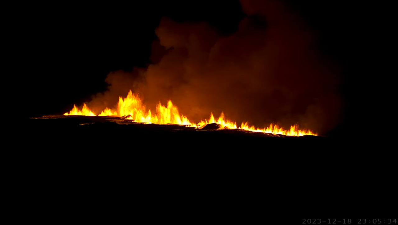
One word: FOUNTASTIC! 🙂
Wow! A Great Curtain of Fires! Like Mauna Loa during the first hours of the 2022 eruption.
https://livefromiceland.is/webcams/fagradalsfjall
Krafla 2.0
Opss change my name adim
Holy crap, those fountains are huge!
Could someone stand next to it? I need some scale.
50 meters high is my guess.
On mbl.is there was a geologist guestimating 100-150m tall fountains
So lucky the Mbl Grindavik cam turned eastwards from Grindavik at 22.15 ish to show the area where it went boom at 22.17.17
https://www.youtube.com/live/hvcP4kVVOnk?si=irCbZvZvcO9MxflP
Several views on Live from Iceland. It can be seen from Reykjavik on the Perlan west cam. The Langihryggur cam is worth a look roo.
A second rift seems to have opened
https://x.com/spahn711/status/1736879720552190108?s=20
The eruption “in the worst place,” per Þorvaldur Þórðarson. “This is perhaps close to being the worst case scenario imaginable.” Estimates are that the lava fountains are some 150 meters high. Source:
https://www.mbl.is/frettir/innlent/2023/12/18/thorvaldur_eldgosid_a_versta_stadnum/
Close to the road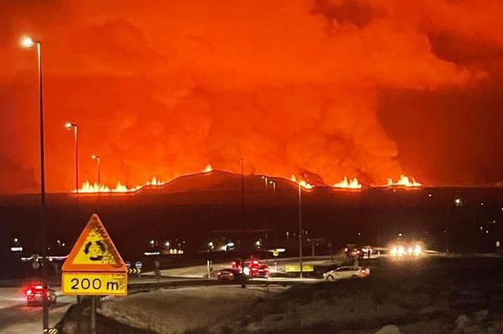
Not a tourist eruption but visually amazing. Let’s hope the appropriate measures have been made to mediate damage
Grindavik may be in trouble
https://twitter.com/spahn711/status/1736881737928433857
Here is the very moment the new eruption began on Iceland’s Reykjanes Peninsula, at 22:17 locally
The fissure continues to expand in length. This appears to me to have a greater flow rate of lava than the previous eruptions.
was just wondering how long the fissure is…
My guess is a kilometer or more. I count 4 or 5 separate segments
Looks like the rift is widening quite a lot. Southward mostly.
Camera zoomed out:
Live with commentary on location’ish drone will be in the air shortly https://www.youtube.com/watch?v=xOUskP7g0gU&ab_channel=IsakFinnbogason-ICELANDFPV
He better not get caught. They’ve established a no-fly zone weeks ago. I think the penalty for violation is getting thrown in … lava. 😀
On the multi-camera view on YouTube I can see the lava has flowed quite a distance already.
Impressive photo from Reykjanesbaer: https://twitter.com/kanilros/status/1736882917308006486/photo/1
Must be looking straight east I would say.
hmmm maybe it embeds:
https://pbs.twimg.com/media/GBqlzvYWcAAtoVo?format=jpg&name=large
Wow I dont watch for a few hours and it erupts. Massive fountains and a curtain of fire, way different than anything Fagradalsfjall did, Grindavik might be in trouble.
It appears to be unzipping quickly with a lot of lava flowing out judging by the Langihryggur webcam. It looks more serious than the previous ‘tourist’ eruptions.
Keeps erupting further south by the minute. You can watch it “move” quite nicely in the Austur webcam:
The eruption magnitude has impresive, and continue break to the south…