
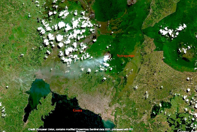
Few people would have heard of Mount Nyiragongo before its current eruption. There are some cities that we know live in the shadow of a volcano. Naples and Vesuvius, Catania and Etna, Seattle and Rainier (although the city itself is unlikely be affected by an eruption), Fuji and Tokyo (with the same proviso). But Nyiragongo is worse than any of these. It erupts often (the current eruption is number 35 since 1882). The effusive lava is very fluid and moves fast. Worse, the mountain is extremely steep for this type of eruptions, reaching 50 degrees near the summit. The lava flow can reach speeds approaching 100 km/h. And the city of Goma, with half a million people, lies directly in one of the paths the flows can take. Finally, this is in the DRC, perhaps the country worst equipped to deal with volcanic risks. Both the 1977 and 2002 flank eruptions had a significant number of fatalities in Goma. In 2002, 13% of the city was covered by 2-meter thick lava as it flowed towards Lake Kivu. And fatalities continued long after the eruption had ended.
Since 1970, there have been 25 volcanic eruptions worldwide with fatalities. By far the worst was Nevado del Ruiz, where 23,000 people died. Second is El Chichon, followed by Pinatubo, Anak Krakatau and Merapi. (In my opinion, Kazbek should be added to the list.) Nyiragonga was already the only volcano to appear in this list twice, with both appearances among the 10 worst eruptions of the past 50 years. And now it is in this list 3 times.
(The number of eruptions worldwide with fatalities has increased dramatically in recent years. Since 2010, there has been on average one such event per year. Before that it was much less. In two cases tourism was involved, but the others were people living in the wrong place. With volcanoes, precaution is the only effective strategy.)

People crossing the hot lava on foot, the day after the 2002 eruption. Many burn wounds resulted. Heavy rain a few weeks later caused dense fog and gas, which led to further fatalities. Luckily the 2021 eruption was in the dry season
We often discuss the dangers of explosive eruptions, and point at Krakatau, Tambora or El Chicohn. Those kinds of eruptions are huge, devastating, and unpredictable. Often the culprit was not recognized as dangerous prior to the explosion. Effusive eruptions are more sedate, tourist-friendly, and predictable but also more frequent. We acknowledge the damage they can still do, and the desperation of people seeing their home engulfed by lava. There is no such thing as a friendly volcano. But Goma finds itself in the worst of both worlds. Its mountain suffers frequent effusive eruptions which come fast and without warning, and are as deadly as explosive eruptions would be. And it is not only the lava. The gas emissions cause acid rain which can damage plant and tree growth on the mountain. Near the crater rim, underneath the volcanic plume, the rain can have pH as low as 2. Low pH and high fluoride has been measured as far as the village of Rusayo, 10 km from the summit.
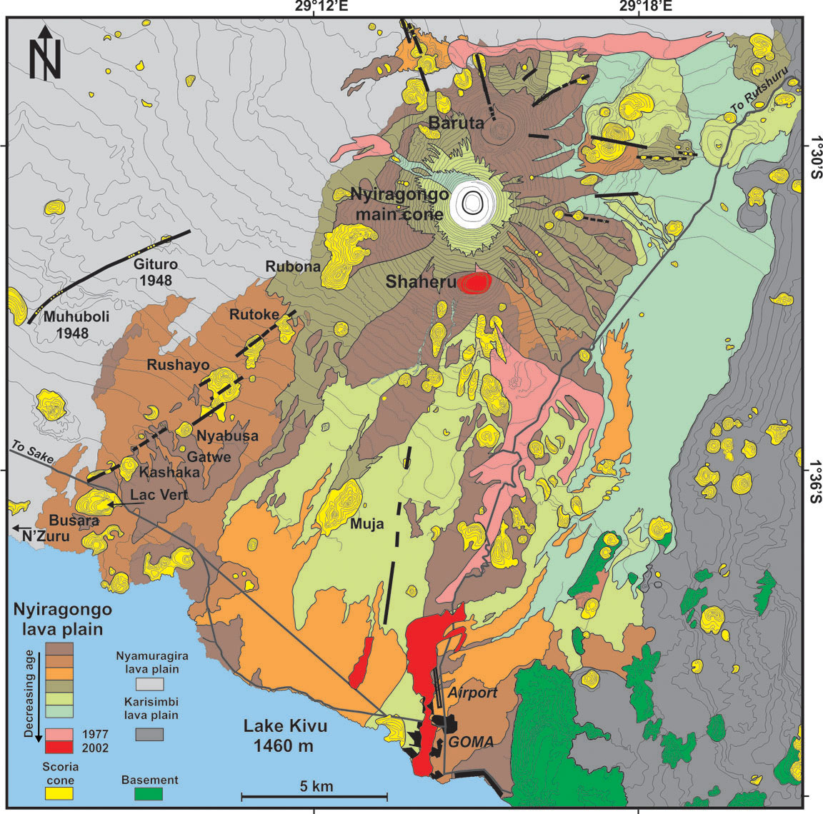
Geologically, Nyiragongo is part of a cluster of volcanoes, two of which remain active. Together they form the Virunga bulge, home of wonders including the impenetrable forest and its mountain gorillas. The bulge sits at the intersection of the Albertine rift (the western branch of the African rift, running north-south – the volcano, as well as Goma and Lake Kiva are located in the rift), and the Kamatemba rift (running northwest to southeast into the Albertine rift). Exactly what feeds the volcanoes is being studied, but a crossing of two rift indicates this is a weak spot. Two magma chambers are suspected, one shallow and one 14 km deep.
The unusual lava of Nyiragongo is attributed to a melting of a carbonated mantle. It differs from all other lavas in Virunga. This seems related to the depth: its magma formed from a much deeper melt than elsewhere in the Virungas. The lava is often claimed to have the lowest viscosity of any volcano known but this is disputed. It is fluid, but the extreme speed of the lava is caused mainly by the steepness of the cone.
The steep cone is not what one would expect from low viscosity lava. It should have build a very broad shield, not a cone. The mountain cannot have been build by these lava flows. There are several possibilities. There may have been a very recent change in the magma. But none of the lavas seen in this area can build such a steep cone. The second possibility is that the mountain was not build from the outside but from the inside. The mountain is in effect the sides of the conduit. Magma rises, forms a lava lake, and the lava lake solidifies against the sides and adds bulk to the mountain. The magma builds the mountain around it. Because this builds the mountain with solidified rather than liquid rock, it can be much steeper than flowing lava would allow. The lava lake has several benches: these benches are how the mountain grows.
The 1.2-km wide, deep crater of Nyiragongo hosts the largest lava lake in the world, some 200 meters wide. The mountain is 3470 meters tall; the lava lake is typically at a height of 2700-3000 meters, while Lake Kivu is at 1470 meters. You can imagine the stress that the sides of the mountain are under! It carries a 1-km wide bucket of lava at the narrow tip of a steep cone. The sides of Nyiragongo are indeed riddled with rifts, many of which are unmapped because of the dense vegetation. These rifts can feed the eruptions, as they did in 1977 and 2002, and apparently also in 2021.

The volcano is about 12,000 years old; the current deep crater is though to have formed a few hundred years ago through caldera collapse. There have been previous collapses: there are two other but extinct craters of similar size, one located two kilometers north (Baruta: visible on the image) and one 2 kilometer south of the current crater (Shaheru). The three cratered cones are aligned: there seems to be a short north-south rift underneath Nyiragongo. This rift follows the direction of the Albertine rift and therefore may have benefited from spreading in the Albertine. In contrast, the Virunga volcanoes overall follow an east-west line. Although the parasitic cones are themselves extinct, they are not immune. During the 1977 eruption, lava erupted inside Shaheru crater.

The flows and source of the 2021 eruption. Click on the image for full resolution. Sentinel image from June 2020
The 1977 eruption formed a rift just above the Shaheru crater; lava flowed into this crater. The 2002 eruption showed lava fountaining above Shaheru from the same fracture. But the 2002 eruption extended this rift much further. The southern flank of Shaheru was ruptured in two places, 300 meters apart. The rift extended downward towards Goma, causing small grabens with lava fountains in several place along the way. These fissures reached the city itself.
Capella radar image of Nyiragongo (https://twitter.com/RaphaelGrandin/status/1396948118067888128). The rift that was active in the 1977 and 2002 eruptions is indicated by the oval.
The 2021 eruption appeared to have started just southeast of the Shaheru crater, close to previous flows. The lava appear to have come through the same fissure as in 1977. The flow split in two, with the longest one heading south, ending within the Goma suburbs close to the airport runway. In the day after the eruption, Goma was hit by several earthquakes which caused cracks in roads. This seems to have extended the activity of 2002, when minor rifting and gas emission was seen 500 meters beyond the lava flows, as far as the airport. In 2021 it reached just off-shore into Lake Kivu. A long crack in the N2 road parallel to the coast also suggests some ground movement within the lake. The rift has thus progressed from 1997 when it formed as 2-kilometer long fracture, to 2002 when it extended by 15 kilometer, to 2021 when it added a further kilometer. Note that this does not mean it is exactly the same crack. Rifts have a certain width and the new crack may be next to and parallel to the previous one.
The eruptions are fed not from a magma chamber but from the existing lava lake. This means there is little or no tremor preceding the eruption as there is no rising magma. Instead, they start when the growing pressure of the lava lake breaks through the steep sides of the cone (a fate the Geldingadalir walls are trying to avoid), involving tectonic earthquakes. In 2002, the eruption was preceded by an M4 earthquake two weeks earlier. This earthquake may be when the break first began to form. The 2021 eruption did not have a clear precursor earthquake. (An earlier claim in this post for a precursor earthquake was based on an erroneous location.) The aftermath is also the same. In 2002 there was earthquake activity on a line between Goma and Nyiragongo for 5 days after the eruption, with the strongest even M5, and in 2021 there were several earthquakes in the day after the eruption also peaking at M5. This pattern adds some predictability to the Nyiragongo eruptions.
But this expanding rifting activity points to another major danger, beyond that of an eruption in the heart of the city. This mountain seems unstable. The rifts in the side are integral to the mountain (that can be seen because many of them directly feed volcanic gasses into the water system). There could be a failure where two of the side rifts combine and one side of the mountain slides down-hill. Such an event would be catastrophic. Most volcanoes in the Virungas show no evidence for a flank failure, but the extinct Mount Sabyinyo does have a big gap in its side and on satellite mages a 1-km wide crater, 2 km southeast of Mount Karimbi also seems to have a gap on the side facing away from Karimbi.
But let’s look at Goma itself. Why build a major city in a place where it has been hit by lava streams three times in the past 50 years?
Goma is at the border with Rwanda. Gisyeni, the part of Goma on the Rwandan side is well connected to the Rwandan capital, Kigali. Travel in the DRC can be more difficult. The area is very densely populated, fertile, with mild tropical climate. The Rwandan genocide in 1994 caused many refugees to flee to Goma, with rebel movements following. The area has remained rebellious and it is not always under control of the central government. People are attracted by the mineral wealth of the DRC. This should be a fabulously wealthy country. Instead, the wealth goes to however manages to profit most. Some of the rebels have a cause. Others just want the wealth for themselves. And earlier this year, the Italian ambassador (who also helped to run the world food program here) was killed by rebels, in a kidnap that went wrong.
And in spite of the insecurity, Goma has grown rapidly. The current population is estimated at 670,000, growing at 5% per year. It is now three times the size it was during the devastating 2002 eruption, and ten times that during the 1977 eruption! New roads have been build (many by Chinese contractors), on top of the 2002 lava.
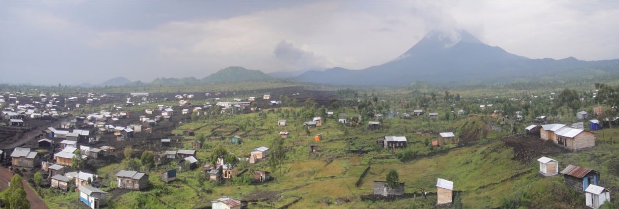
In view of such unstoppable growth, where do people live? They can’t go east, towards Rwanda, as Gisenyi is too small and itself has no room to expand. West gives some space but quickly takes them out of the rift valley. South lies the lake. So the city grows west along the lake shore, and north on the plains leading to the Virunga mountains. Much of the land is already taken, and so people build houses where they find unoccupied space. People have to get to work, using the taxis, any ride they can get, or by walking. So they live near the roads. Conveniently, there is space here which is not farmed or otherwise occupied. That is, they build their houses on top of the recent lava flows.
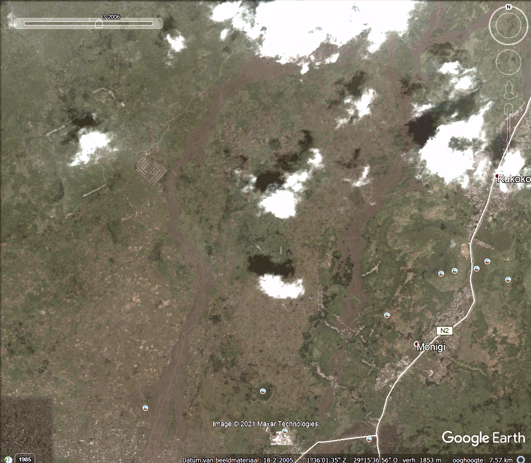
A time line shows the growth of Goma. The image below is from 2005, when the 2002 lava flows are still visible.

Goma, 2005
The most recent image, from 2019, shows dramatic changes.
Goma, 2019. Click on the image or here to see a timeline
Putting the Google earth images together (thanks Gijs, Lughduniense!) shows the rapid expansion in a time line of Goma’s growth towards Nyiaragongo..
As you can see, the expansion of the city follows the 2002 lava flows very well, along the roads build on those flows.
But the lava flowed along those paths for a reason. Nyiragongo can erupt in all directions, but in the three major eruptions of the past 50 years the lava has gone south, following the underlying north-south weakness in the mountain. This rift formed in 1977 eruption, was re-activated in 2002 and possibly again in 2021, extending through the city and now into the lake. The rift provides a pathway for the lava which inevitably ends up in the same area as before, following very similar flow paths towards the lowest points. The people are living on a ticking time bomb.
They do so not by choice, but because they too have to live. These are not refugee camps, put wherever others can’t see their plight. They need houses to live and places to work. They are people just like us.
And now Nyiragongo has erupted again. The precursors were too weak to be seen on the few available instruments and by the few scientists. Do not expect magma signals: the lava is already in situ and all it needs is to break through the crater wall. The precursor was probably a faint tectonic signal. People knew that a new eruption was imminent. The lava lake had grown too big. But they did not know when. Suddenly the sky went red and the lava came. Eruptions of Nyiragongo only last a few hours. By the time the alarm was raised and the evacuations had started, the lava was already among the people. We do not know yet how many casualties there were. So far, 500 houses are reported buried, 23 people died from the eruption and 9 from a big traffic accident in the evacuation. The real toll will be higher and may never be known.
Proposals have been made to safeguard Goma. Dams could be build to divert the lava around the most endangered area in east Goma. The problem is that this would divert the lava towards other areas that are just as densely populated. Warning systems have been proposed, already 25 years ago. But hardware on the ground does not last long, often due to theft. Before the 2002 eruption, only 2 of 5 installed seismographs were still working. The rangers who lead the expeditions to the lava lake do report anything unusual – but it needs people to collate and analyse the reports. The 2002 eruption has been predicted in advance by the local scientists, based on reports from the rangers and the little instruments they had. There was failure of action on these warning by the authorities – who in any case do not carry much authority here. The 2021 eruption was expected but was not predicted.
What can be done? Monitoring from space is difficult because of the near-perpetual cloud cover over the peaks. Seismographs could be placed in Rwanda, not many kilometers away. But that is a different country and they cannot issue warnings for Goma. With such a volcano, an eruption warning needs to be instantaneous (in 2002 lava reached Goma within 20 minutes, and because the rifts extends into the city the eruption could in theory begin within the city limits), and should be unmissable. It can be done – even here, most people have mobile phones. Pre-eruption warnings need to be accurate, otherwise they will quickly be ignored. That requires significant scientific effort. And finally, we need predictions where lava is most likely to flow, and discourage people from living there. East Goma in particular should not be there. That may be the hardest task of all.
Goma was lucky this time. But there will be a next time. And one after that. And one day this could become the Pompeii of the tropics.
Albert, May 2021
Addendum 27 May 2021
A new INSAR image has appeared show ing spectacular changes in the rift valley. The image shows the changes between 19 and 25 May (i.e. including the eruption but not the subsequent tectonic activity). It is reproduced here (at reduced resolution), with the original taken from https://pbs.twimg.com/media/E2U9GXEWEAU55XF. The INSAR data is also available from https://sarviews-hazards.alaska.edu/Event/221?pinned=d989972a-8f8e-4337-9744-f9dbb668ef33,406295fb-403e-4604-acc9-4cd65ddeae09
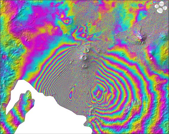
Sentinel INSAR data, 19-25 May 2021
This looks very much like a dike intrusion but there are two aspects worth noticing. First, the coloured contours are best visible along the side of the rift valley. Second, the colour sequence on the left and the right of the valley are reversed (look for the order yellow-green). It is always hard to separate up/down from left/right in these plots (the satellite measures the distance from the satellite to the ground, and if it is not directly overhead it will see both). The reversal suggests that the sides of the rift valley are moving away (or towards) from each other, i.e. rifting. If they were moving up (or down) you would see the same pattern on both sides.
So there is rifting. But there is not much indication for a large dike. That would show up as inflation in the centre and that is not really seen. (Unless it is localized in the feature near the lake coast which coincides with a ridge in the landscape).
We will wait for more data. I think there is rifting between Shaheru and Goma. Whether there is lava inside the rift remains to be seen.


Finaly a Nyiragongo Article!! Thanks albert
This is one of the worlds most unique volcanoes .. the most unique perhaps 🙂
I woud not mind more articles about it
Great read .. Reading now
Good stuff as always Albert.
Those two 2005 to 2019 images of the expansion of Goma pretty much underline that sooner or later it is inevitable there will be a truly catastrophic event with this volcano. How do you even start to relocate a city in a region that has been in a state of political unrest for decades?
Not been any major wars in the region since 1990 s .. but Nyiragongo is Probaly now the main problem
Just imagine if a flank vent cone forms in the middle of Goma! Nyiramuragira 2011 coud happen in middle of Goma .. and kill thousands at fissure initial start
Real flank cones of Nyiragongo haves a Melinilite-Lecucite composition Thats one of the strangest and rarest sillicate magmas on the planet.. togther with the Nyiragongo Nephelinite
No major wars since the 90’s? The Second Congo War and the aftermath has been the deadliest conflict in the world since WW2. The war “ended” in 2003, but the fighting never has to this day. There is still active fighting where villages change hands and just last month the military tried to take control of the entire region of North Kiva. The volcano is just another tragedy in a long list.
It’s depressing to think that if the worst would come – a limnic explosion of Lake Kiva killing 2 million people or so – that it still would be less than a third of the death and destruction that region has seen in the last 30 years…
Exactly the same happened in 2002. It took 5 days for the activity to calm down
Sorry, this was in response to 67doug (what happened to 66doug?), and not about the forever wars.
Rubavu side or Kalungu coud be a good place to move Goma But Lac Kivu gas threat remains .. but they will be spared from Nyiragongo and Nyiramuragiras lava flows
But woud not be supprised If we gets a monogenetic eruption soon in the Kivu lake too
Didn’t Rubavu erupt in 1920s? I’m not sure what’s the bigger issue – the volcano or the lake.
I know it’s good to be beside water for irrigation, fishing industry etc. but the risk of limnic overturn isn’t worth it for me.
How do you relocate any city? The only cases I am aware off is after the city was destroyed. Guatemala has done it. It happened to some of the old roman cities in the UK where the anglosaxons build new cities a few kilometers away. There are cases where people build a new city (Brasilia, perhaps now new-Jakarta) but those never emptied another city
Jakarta, I believe the government and large institutions are relocating, but many will not be able to afford to until forced to flee the inevitable flooding.
The cost is going to be staggering, at $33 billion; but includes a Palace complex. The president is hoping to kick-start the post covid-19 recovery with the revival of the move, targeting the vaccine programme so building can commence.
There are a couple of good articles:
https://www.dandc.eu/en/article/even-if-indonesias-government-relocates-kalimantan-problems-former-capital-will-deserve
https://theaseanpost.com/article/jakarta-relocation-answer
The entire city of Kiruna in nothern Sweden is being moved right now. It’s beacuse the Iron ore mine is undermining the city, and to continue to grow the mine they are moving the city.
Germans emptied villages because of the mining. Build completely new houses for the ppl.
Nyiragongo must be what most people imagine a volcano should be like – deadly gas pockets, Steep Slopes simple shape hot fast lava, a
lava lake, and a beautiful conical profile rising out of the jungle.. and far far away in a ”dark poorly known” mysterious land
As stereotypical as a volcano can be on Earth
Just like every child imagines what a volcano woud look like. Nyiragongo is souch classic shape and everything it almost look like a film prop
Iconic volcano for soure
Back to Iceland for a moment, am I seeing some activity in the Number Two vent (Northern most). Or is it my imagination working overtime, and not using a big enough screen?
You are not alone… i’ve seen it too.
Thank you for this sobering article Albert. One feels a sense of helplessness over the citizens of Goma. Really, they ought to move the city but people have such meaning attached to their homes, and the costs of displacement are high.
The only way they could do it is to move out one by one. And I doubt their government would care to help.
Helplessness is the right word, I feel it too.
Great article, Albert, as usual with lots of details and precise descriptions, thank you. I met a new rift for me, Kamatemba.
The main problem is mentioned, and that is, besides the volcano, the enormous growth and sprawl of a city without room. I am thinking of Brasilia. Brasilia was built from scratch – also extraordinarily pretty Milton Keynes. And I think that in the long run the whole place has to slowly move North or South which must start with the government and the airpoirt, some industries and people follow.
However, with all those particular interests there it would be quite difficult. Besides I think in case the Chinese are involved in winning resources – somebody mentioned this under Carl’s piece – they wouldn’t care about the lives. And also, if people moved, new people would settle there knowing about the danger.
So, it seems to be an unsolvable situation which the volcano or the lake will solve lethally one day. A lasting peace with neighbours and a hard stance against terrorists might help though.
Answers to one question I tried to find myself yesterday staid in the dark: It says, on wiki i.e. that the stratified lake degasses around every 1000 years, possibly linked to the volcanoes, so I tried to find out when this was last and only found an article for 3.500 years ago:
https://www.bbc.com/future/article/20201009-lake-kivu-the-african-lake-that-could-explode-with-methane
Your usual British academia style sense of humour is missing here, understandably. It’s a nasty situation. Thanks for writing this.
Yes, light-hearted writing seemed inappropriate for this situation. The 1000 years is the upwelling time: it is how long it takes the CO2 from the deep to diffuse upward. The lake is currently stable. Actually, methane is more likely than CO2 to destabilise the lake, but will not happen unless methane production in deep water increases. Indications for a past overturning come from zoology: there are very few types of fish in the lake, and no plankton. These suddenly disappeared 5000 years ago. This is when Virunga eruptions began to reach the lake. The suggestion has been made that this included a deep water eruption which caused overturning and wiped out all life from the lake (Haberyan 1987). Current papers date this to 4000 years ago, related to a drought, with no indication it happened more than once (https://www.sciencedirect.com/science/article/pii/S1464343X19302699). But the sedimentation has increased in recent times and that has raised some concerns. The volcano remains the primary concern
Thank you v.m. for answer and link.
Nyiragongo haves one record ….
It haves the lowest sillicate content 36% for all sillicate based magmas on the entire planet
Nyiragongos Nephelinites are down at 36% and most other more normal basaltic lavas are
50 to 46% sillica
The very low sillicate content as well
as relatively high temperatures is behind Nyiragongos low viscosity
Nephelinite Thats the typical magma from Nyiragongo is the product of the smallest ammounts of partial melting less than 1% of the mantle rocks so its extraodinary rare on Earths surface
Nyiragongo is Superalkaline – Super Sillica Undersaturated
Nyiragongo is at current only Active example of Nephelinitic volcanism in the world. And probaly very hot for being superalkaline composition basicaly Hawaiian style activity in Nyiragongo
Lecucite-Melinilite is erupted as monogentic cones around Nyiragongo another extraodinary rare ultrabasic rock.
Little is known about how Nephelinites behaves outside Nyiragongo .. but because they are product of souch little partial melting many probaly erupt as cool viscous Strombolian flows.
It is funny that the lava is so different from that of all other volcanoes in the area, past or present. It comes from greater depth. Note it is in the middle of the rift valley. I was wondering whether a bit of deep melt managed to get up right through the centre. No oceanic crust is forming (yet) in the rift valley: the crust is stretched but not broken. But perhaps a hole was formed here. It is not pure mantle melt though and it has been suggested that very old subducted ocean floor lies underneath the crust. That seems speculative.
Partial Melting is at current way too low in Albertine Rift to form normal basalt oceanic crust thats a product of high ammounts of partial melting
Before any Thoelitic oceanic crust will form
In this arera .. there may be a major flood basalt.. as a huge sourge of partial melting with an arriving plume head Thats resposible for the crustal litosphere dome in this part of congo .. But Thats for the future
Nephelinite is a mantle melt But the product of tiny tiny ammounts of partial melting
Albert: this volcano is unique in the world! Tell me any other sillicate volcano that have a sillica content as low as 36%
Nyiragongo at current is down at 36% sillicon dioxide extraodinary low .. No other active sillicate have
Nephelinite Nyiragongos magmas is one of the most pure mantle melts that you can get
But its also product of very very very small ammounts of melting .. so little melting that its an extraodinary rare extrusive rock
The plutonic coarse grained form of Nephelinite is called Ijolite
The smaller the partial melting is .. the more
sillica undersaturated and alkaline the mantle melts become
Nyiragongo is the Peak of Alkalinity and sillica undersaturation ..
All these from me can be as information in your next VC article ”The Science of Nyiragongo” as proposal for next article
Proposal accepted!
Great. On wikip. there is a picture of a Ijolite 124-125 mya, from – very interesting – Québec.
Nephelinite also exist in the older Hawaiian Islands Thats been removes from the Hotspot
Oahu is full of late stage Nephelinites : )
Yes needs to be content with Nyiragongo on this site.. its souch an unique volcano
There is No other volcano for now like this
Maybe somebody can get a hold of this: Abstract:
Mt Etinde is a volcano situated on the southwestern flank of the large Mt Cameroon. Its eruptions are dated at 0·65 Ma and took place during the Mt Cameroon eruptive cycle (6 Ma with recorded recent activity). The lava types, unrelated to the Mt Cameroon alkali basalts, are melanephelinites, nephelinites sensu stricto, and numerous and varied nephelinites that contain one or more of the following species: nosean, melilite, perovskite, garnet, aenigmatite, leucite, feldspar and haüynophyres. Clinopyroxene is the dominant mafic phase, with a variable composition between Al–Ti augite and aegirine. Zoning is also present in garnets, with conspicuous Ti enrichment in the border. Aenigmatite includes a fair proportion of Fe3+ Tschermak’s component. Melilite is systematically Sr rich; its SrO contents increase continuously with MgO decrease, reaching 16 wt % in some facies. The chemical composition of the lavas is extreme, with unusual concentrations of volatiles (CO2, H2O, SO3), most incompatible elements, such as Ba, Sr and Zr, and the light rare earth elements (LREE). The Mt Etinde lavas define two lineages (MgO poor and MgO rich) that partly overlap. The chemical evolution of these two lineages can be reproduced for major elements using a simple model of crystal fractionation. The major fractionating phase is an aluminous clinopyroxene, in accord with the petrographical observations. The scheme proposed can only be validated if the alkalis are not taken into account, a hypothesis warranted by observations of other nephelinite provinces or ijolite massifs and their fenite aureoles. Nephelinite magmas were obviously generated at great mantle depth, but their exotic composition can only be produced by partial melting of a metasomatic mantle. Comparison with other provinces would point to a source that has undergone carbonatitic métasomatism.”
Title: Petrology of Mt Etinde Nephelinite Series
Journal of Petrology
It popped up when I googled cameroon+nephelenite, and that idea had to do with those lakes.
Off-the-cuff guess: the mantle under a region extending from the Cameroon Volcanic Line to the Virunga region is uncommonly rich in CO2, perhaps from a large ancient limestone-rich slab (former Iapetus seabed?) breaking down at the transition zone and exuding carbon. This could explain all of the following:
* The only known limnic eruption lakes, Nyos and Kivu, are near the opposite ends of that region. Very high CO2 seep rates needed for this. Extra mantle CO2 would go a long way towards explaining this.
* Ol Doinyo Lengai’s weird carbonatite magma chemistry. Extra carbon.
* These nephelinites. The Cameroon ones, according to Denaliwatch, have unusually high CO2. Maybe high CO2 can also cause nephelinites as well as carbonatites. What happens if carbonatites fractionate in a storage region? What bubbles to the top?
Nephelinite is mostly a product of very small ammounts of melting in the mantle
You will see more in alberts next article I think
Twisted one, this guess might be good. There’s a horizontal rift line from Cameroon to the East. I don’t know though whether it’s an active rift, an old rift or a transform fault.
There’s a second stratified lake though in Cameroon, Monoun.
Where Tethys said good-bye, there are usually mountain ranges like in India or in the north of the Mediterranean, without significant volcanism right now, albeit in the past.
I think that there might not be enough research from the centre of Africa though because of obvious problems in DRC and CAR.
I’m wondering whether Albert might say s.th. about this in his next piece. For Mount Cameroon and the area Carl has a great piece
in the Africa section.
Congrats, Jesper!
”The Science of Nyiragongo”
Is my Idea of Your next VC article
Takes up what Nephelinite is for something
The Viscosity contest with other magmas
The geological history of the arera
Little of the human history of this arera
And exploration of Nyiragongo as well as this arera
The tradegy of 1977
And other things related to Nyiragongo
Sounds good! And it is probably enough for more than one post.
https://mhalb.pagesperso-orange.fr/kivu/images4-diapo/photo14.htm
https://mhalb.pagesperso-orange.fr/kivu/images4-diapo/photo12.htm
https://mhalb.pagesperso-orange.fr/kivu/eg/eg_4h_eruption_photo.htm
More Photos lowest link
Photos of the 2002 eruption showing the extraodinary low viscosity of Nyiragongos Nephelinites at least near the vents .. but its also a product of very high eruption rates …
But fluid enough to cover twigs and boulders in thin shells of lava glass and coat everything.
But similar features been seen in very hot thoelitic basalts at Mauna Ulu drainbacks and 1923 eruption
But look closely at the trees and boulders in This photo and Nyiragongos incredibley low viscosity becomes clear, a hot Nephelinite haves very little sillica polymerisation https://mhalb.pagesperso-orange.fr/kivu/images4-diapo/photo12.htm
Albert perhaps use These Photos in Next Article .. they really shows How extraodinary low Nyiragongos Nephelinitic viscosity is
Really is No other at current active volcanoes with magmas like this on the entire planet
Nyiragongo is unique and a great favorite volcano of me
Theft problem aside, would a lahar detector such as those mounted around Raineer be able to hypothetically detect a Nyiragongo lava flow passing them?
This lava is so fast that they would need to know warning signs before the event, I guess, Compared to the Baby Volcano I named “Pretty” where people can walk by, build walls in peace and quiet this is Kingo-Gongo or Wonder-Chicken versus T-Rex.
In 2002, when they were able to monitor the volcano, there was enough warning from seismic activity, long period events and volcanic tremors to evacuate Goma.
Warning once the lava lake started to drain would be too late for some.
Thank you Albert for a factual article on the plight of Goma. My father was city engineer of a town in Southern CA whose residents wanted to build trailer parks in the river bed. He said no, but the mayor overruled him. Sad to say, the 100-year flood hit and the trailer parks were completely flooded, some taken down the river towards the ocean. The people bitterly complained to the city and even tried to have my dad fired. But he knew what was coming and had extensively documented his warnings to the city.
I feel the same sadness here, but even more. I really don’t know how you could convince people to move. It almost seems as if people are setting themselves up for a truly big disaster.
I appreciate so much that you care for human beings, thank you again for discussing Goma’s plight.
– Randall
There is a story emerging that the seismographs on Nyiragongo had not been working for some time because of lack of funding for an internet connection. A fact-check may be needed.
Haven’t there been images from the seismograms on the internet? Not sure which stations they came from though.
OTH you cannot get data for earthquakes less than 4 / 4.5 from EMSC for the area.
In french
https://actualite.cd/2021/05/23/rdc-nyiragongo-le-danger-na-pas-ete-percu-plus-tot-parce-que-pendant-longtemps-lovg
https://actualite.cd/2021/05/26/eruption-volcanique-la-dgda-contrainte-de-liberer-les-materiels-de-lovg-bloques-dans-son
Some information here
https://georiska.africamuseum.be/en/news/nyiragongo_eruption
https://www.africamuseum.be/en/research/discover/news/hazagora
So basically they had two seismometers working but no internet connection until they were helped by an American partner, so no monitoring from October 2020 to April 2021. They saw some activity when they started monitoring again but thought it was [of] recent [origin]. Additional monitoring equipment was stuck in a customs warehouse but has now been released by the government.
Someone give them some drones so they can check the craters and flanks of the volcano.
One seismometer was 150 km away but no-one went to check it …. ?
They been sold on Goma markets long ago.. : D D : O :
Despite quite alot of poverty and political tourmoil through previous decades .. Goma is still a beautyful place. The virunga Mountains, The
”evil” red nightglow of Nyiragongo – Nyiramuragira and the beautyful cumulus clouds and tropical greeney and snowy Karisimbi, constant chattering of the locals, persons playing on Kivu lake shores, Kivu fishermen drawing in nights huge catfish..
I coud easly relax there for years
Im so tired of my home … : (
Nyiragongo haves a quite ferocious local legends around it! This is the place where criminals go and burn after they die in next life..
The lava lake lava fountains are these unwanted ”crooks” as they swim in torment through everlasting fires of Nyiragongo.. fountains also are the demons stirring the hot soup of sin ..
Well behaved Goma residents ends up in the heavens in the fluffy clouds and snows in Karisimbi ..
Thats the local views I think after some research..
very similar to European christian views .. but Nyiragongo area have lots of local legends
Where is your home?
At current in Lapland at friends
This place .. sucks
No Nyiragongo
No Nephelinite
No Ultrabasic lava to enjoy you know
More drone footage from Iceland
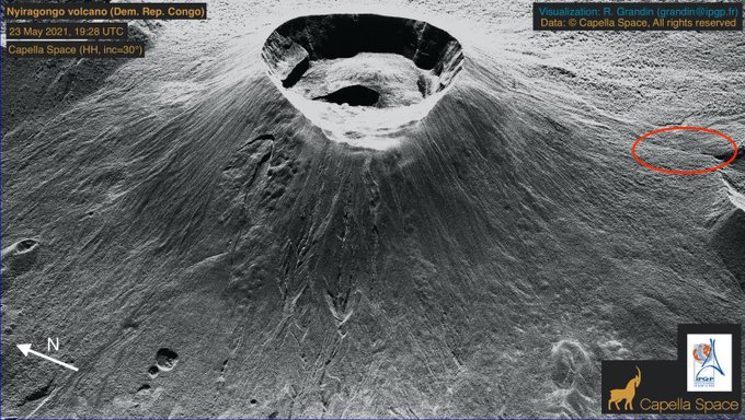
Any aircraft Photos yet of Nyiragongos summit caldera? Volcanologist Dario Tedesco flew over Nyiragongo a few days ago and they coud not see any lava lake .. it have been drained into the abyss leaving a deep pit filled with rubble
No Photos from that yet
I haven’t seen any as yet, very interested to see some as it looks like the pit collapsed (from the radar images) and the side of the crater slumped in
InSAR Data on Nyiragongo looks like a intrusion
https://mobile.twitter.com/SARevangelist/status/1397392012475715589?s=20
I wants a webcamera on Nyiragongos summit
But the Kleptomanic locals always steals them and they quickly torn down into pieces and sold on Goma markets as usable electric pieces. As fast as Volcanologists place equipment .. then they vanish the next day
If there are no choices, people cannot choose. Here or nowhere. Thanks, Albert, for explaining the big picture. Read this to Hubby and he said he liked the style and rythm.
Volcano Discovery reports that the ground to the south of the volcano has risen by several centimeters and the earthquakes continue. This *could* be the formation of a new dyke or lava filled fissure.
That possibility does not sound good
One of those cracks had visible magma underneath and parts of the lake are bubbling.
Lava tubes under the city?
Seems kind of like Taal with the cracks showing up everywhere, but Taal is a different type of volcano.
https://www.instagram.com/p/CPWFZ9IJlP_/?utm_medium=copy_link
Extreme High Res Closeup of Nyiragongos weekend eruption fissure .. really flowed like a glass flood there.. coated the ground in thin shells of pahoehoe.. but similar features is also seen near fissures at Mauna Loa and Kilaūea
No lava drainage into this Nyiragongo fissure .. suggesting the crack got that wide after the lava flow stopped flowing from there
Just like the Great Crack in Hawaii, almost exactly so in fact.
I mapped the vents too and this is nearly in exactly the same place as a 2002 vent and all 3 recent eruptions broke out the same line, the same fissure. Can be called the Goma Crack…
If there are cracks opening in the city now next time around I fear the worst will be realised…
Amazing How these trees near the vent was not toppled by the flow
But it shows its extremely low viscosity close to the vent .. flowed almost turbulent around these trees
Farmers upslope to 2002 vents where burned to death when the lava flood came..
And in 1977 a whole elephant herd where covered in Nephelinitic glass
It woud look close to vents very much like an liquid aluminium flood .. hot glowing yet metallic looking Nephelinite gushing from fissures at high rates
That is some fissue
Not as interesting as Nyiragongo but Great Sitkin had an eruption today. Reading up on it apparently there has been volcanism in roughly the same spot for 33 million years, subduction has been by and large unchanged for the last 47ma. Incredible
Thank you for this article, some great info that I had no idea about.
And for some reason the focus always goes back to Iceland, sorry about that. In two weeks time we’ll be able to see a partial solar eclipse above the volcano, hopefully a webcam can be turned in the right direction. https://www.timeanddate.com/eclipse/in/iceland/reykjavik

HVO is edging towards calling the Kilauea eruption over. They are still seeing some incandescence but no active lava
Video of old overlook lava lake
2008 – 2018
https://www.usgs.gov/media/videos/spattering-k-laueas-summit-lava-lake-4
Nyiragongo vs Kilaūea
Kilaūeas summit is the great contester in most fluid viscosity with Nyiragongo. Halema’uma’u can look like liquid Aluminium ..Its very runny too!
Sometimes kilaueas lakes looks just smooth and fluid as Nyiragongo
Nyiragongo low Sillica is not the only factor. High Temperatures is too!
Kilaūea is higher in sillica But also ALOT more partial melting in Hawaii .. so Hawaii can be extremely hot ( Hawaii is the worlds most powerful hotspot ) Hawaii is really runny and smooth.
Kilaūea s high temperatures likley makes it just as runny as Nyiragongo
Most strongly alkaline melts like Nyiragongo are cooler than Plume basalts.. and more viscous
But this video of Nyiragongo shows it too .. as extremely fluid https://m.youtube.com/watch?v=VvQKCX3L-44
Hawaii haves very very very very very fluid viscosity at Kilaūeas summit .. making it questionable that Nyiragongo is the pure winner in low viscosity among sillicate magmas
Halema’uma’u can look like liquid Aluminium ..Its very runny too!
Many USGS videos shows old overlook lava lake looking like a huge pot of lovely aluminium Thats sloshing around
Looks like at High Temperatures
1250 C for some Halema’uma’u magmas .. the 50% sillica content does not make much diffrence from Nyiragongo at 36% sillica ..
Erta Ale looks just as fluid, it looked like a lake of aluminium when I saw it. I have videos that look the same as the one of Kilaūea you posted
Erta Ale lave lake in 2015
There has been studies done, Nyiragongo is maybe slightly less viscous than Hawaii but it is within margin of error, it might also not have been including the 2008-2018 lava lake either. The major reason for the extreme danger is the steep slopes and the height of the lake above the surroundings, both of which are way more than anywhere you can get an eruption in Hawaii. Still, flows on Mauna Loa move plenty fast enough, and we havent really got enough data on Kilaueas prshistoric flank eruptions to say there arent a lot more eruptions like 1823 in its record, one of those in lower Puna would be far worse than 2018 even if insignificant in volume compared. One of the eruptions in the 1780s might have been like this from what Hector said.
Photo of Nyiragongos 2003-2021
lava lake showing some features that certainly haves to do with extremely runny viscosity .. a thin thin crust .. with thin plates… and small bubbling zones
It has been very quiet.
The supply to Kilauea seems to have lowered quite a lot from the surge in December 2020. In April there was basically no inflation anywhere in the volcano and the lava lake was barely rising. It looks like there may have been some increase in inflation during the last 2 weeks, but it hasn’t affected the lava lake, perhaps the dyke feeding the eruption has solidified already? Or it could also be that the inflation has not reached the most shallow parts of the summit storage? Shouldn’t be too long before Kilauea gets moving again though.
While my heart is with the Congolese in Goma. Damn, Island volcano during sunset is just so sweet. I *need* HD photo of this for my desktop.
Albert,
thanks for the article. With the very little info we know – is there risk that Nyiragongo will do a major rifting episode like Kilauea even within this cycle? All these eqs – is there good reason to consider this episode as done and over?
Jesper,
we all would love to have any monitoring on those volcanoes. Insulting the locals really betrays the misunderstanding of local misery. Please be more respectful.
It did this in 2002, it seems to me the volcano is not big enough itself to erupt in large volume during a rifting event, so the lava lake drains out the upper flanks following the rift and a deeper non eruptive intrusion happens.
Like Jesper said the cones are a different composition to the lava lake so probably dont have a lot to do with it, most likely the majority of them predate the main formation of Nyiragongo itself, which probably has also changed its eruptive style recently as it is mostly tephra, it must have been a fountaining Etnean volcano until its first caldera, think Pu’u O’o but way bigger and longer timescale.
And yes I think there is not a lot of sensible thinking going on here, it is a forum for scientific discussion but when there are people involved it is different. I dont want to see Mauna Loa through a flood basalt in the middle of Ocean View. I dont want Campi Flegri to erupt either, even though it is exiting that is only because it hasnt happened yet…
Jesper isn’t insulting. Those people are not stupid. It would be criminals who steal this sort of equipment. Rough words is really not direspectful. Criminals are disrespectful. They might buy a car from the money they get for the equipment, and others die. It’s them who don’t care. People here care, which is obvious.
Quick note on Iceland: show a gradual lessening of amplitude. If this continues, will we end up with just a sloshing lake inside the cone?
The changing cone morphology shows that the eruptive bursts are quieting down and not splashing as high. Some of the traces in the
“ “
“
I’d like to focus people towards the Krisuvik and nearby drumplot charts. There has been seismic activity in the area which may emanate from the Keilir area. As we know, that is the northern end of the current intrusion. The charts have shown wet seismic signals, rock cracking and other events around the 5km depth. That suggest the intrusion may be creeping upwards.
So if our current vent is winding down, we may yet see new activity further up the rift in the next couple of years.
How far has the lava got to go before it decides to take a right and go down the hill?
https://imgur.com/CMWYtKN
Source: https://www.youtube.com/watch?v=BA-9QzIcr3c around 15 mins ago from the time of this comment
Correction: it would have to take a left, not right … 😉
The camera is at an elevated location, so the perspective makes the lava look closer to overflowing than it actually is. Go to the 3d model and view it from both sides. This one is a few days old, but you still get the picture that there is not that much difference between the lava level in Geldingadalir and nameless valley.
https://sketchfab.com/3d-models/fagradalsfjall-volcanic-eruption-18052021-73adeb1d4ed54eedb8ee8372836d965d
Think the lava has risen a lot in both valleys since 18.05.2021.
See my response below.
The latest episode (#105) of Reykjavik Grapevine, focussing on the lava flow in Nátthagi valley (include footage from Saturday, the day the wall was breached).
https://grapevine.is/news/2021/05/26/rvk-newscast-105-the-new-lava-threatening-the-highway/
Like Gutn Tog before, he mentions plans for diverting/slowing down the flow towards the coast with new dams. It seems they had their proof of concept with the previous walls.
I watched this with headphones. Incredible sounds, I didn’t want it to end. What an inspiration for some music…
A new Video with new facts from the eruption from Prof. Olafur Ingolfsson from just a few moments ago
Well, it looks like this eruption could be 1977 all over again… That massive raging lava flood that was caught on video the first night flowed right over a small village immediately, the lower fissures seem not to have opened yet so this was basically the full lake drain out of the lowest section of the first fissure. The flow into Goma was from the one in Jespers link.
There really needs to be a revision of the idea effusive volcanoes are not dangerous, it is such a pervasive and dangerous myth that you can walk away from lava that someone is going to kill themselves in Iceland soon. The worls also needs to realise that it isnt just Nyiragongo that can erupt this way, tucked away in some ‘other part of the world’…
https://imgur.com/a/TenJBcd
https://imgur.com/a/0ee1wV5
https://imgur.com/a/TenJBcd
If an admin could make this links into pictures.
Mauna Loa and … Specialy Hualalai
Can be extremely dangerous with their fast eruption rates and relatively steep slopes combined with lavas thats not far from Nyiragongo in viscosity
The dangers there are same as Nyiragongo.. superfast moving Aa flows feed by fluid channels upslope.
Mauna Loa South rift eruptions start 40 km upslope on the rift .. like real hellfloods and the very fast moving channel Aa goes to the ocean communities in just 2 hours.
Hualalai is just as dangerous .. historical eruptions been producing almost basanite 42% sillica alkaline basalt that flowed very quickly indeed in their channels upslope. Hualalai haves Some huge spatter cones .. so many eruptions are far from small there
They are so close to eachother the Giant Volcanic Complex that makes up the Island of Hawaii
Yet .. they behaves and are
5 induvidual separate giant shield volcanos
Yes, Hualalai is one of the volcanoes I have found to be very underestimated. Its activity is separated by periods of 400-800 years of nothing, with eruptions every few decades to maybe a century or so within phases. The last one began in 1650 and is ongoing, as there was an intrusion in 1929 that seems to have been significant in volume. There will be an eruption there again this century I expect, a nightmare cross of a lava flood and an Etnean fire fountain… I do worry that because it is on Hawaii people will think it is not dangerous, but I think after 2018 that is not a problem…
Very Correct .. imagine placing Fissure 8 on Hualalais steep slopes! the result woud be terrfying.. downslope
And many of Hualalais spatter cinder cones Dwarf fissure 8 and even Holuhraun in size.. yes 800 m tall fountains and massive channelized Aa rivers.. and perhaps a scary fire curtain startup
Hualalais 1800 s lavas are almost Basanite .. very sillica poor and clearly very fluid .. perhaps somewhat more fluid than the avarge thoelite
Hualalai is like Hekla but with superfluid lavas. It is even the same shape really, but it is much bigger.
Really the only thing it shares in common with Kilauea and Mauna Loa today is its location on Hawaii, otherwise it is very different. One eruption about 1000 years ago had a 1800 meter tall lava fountain, think something as big as what Etna did in March but it lasts for days if not weeks, it was basically almost a plinian eruption. A very similar eruption about 200 years earlier and a few km north actually has an explosion pit crater and has been described as a subplinian deposit, the eruption progressed from an initial lava flood into a violent high fountaining eruption.
It looks like the hill will be cut off very soon
I think the surest sign of that being imminent will be the closure of the trail beforehand.
And the trail looks suspiciously empty…
The cam just zoomed in at it definitively looks like the lava is creeping over the neck.
Drone crashes into the volcano in 4k
https://www.youtube.com/watch?v=j18ECUhkeY0
Why do they intentionally destroy the drones ?
Wow its Gollums last view really
Viking funeral
crash bait
Trying to stop the eruption by clogging up the vent! 🙂
Nonetheless, an awesome look at the huge volume of magma pouring out of the vent.
Any chance they might have lost control, or maybe the drone was already damaged so, as Chad said, Viking funeral?
The fiberoptic cable burried in dam is still working fully as intended, it is burried about 70-100cm deep(just like the important real cable further down the valley) and there’s about 4m of lava on top https://www.ruv.is/frett/2021/05/26/ljos-skin-enn-undan-hrauninu
All that is needed is to bury the cable in a waterproof pipe that you pass water through to cool it. Its clear solidified lava is a good insulator so it should be relatively easy to maintain a safe temperature over several hundred meters of buried cable.
Now might be a good time to relay it.
Nice picture of Great Sitkin, Alaska, erupting from Anchorage News:
https://www.adn.com/alaska-news/2021/05/26/aleutian-volcano-great-sitkin-briefly-erupts-sending-ash-15000-feet-high/
Old eroded lava channel very close to Nyiragongos crater rim.. yes sometimes Nyiragongo fills up right to the rim with lava lake overflows .. and the steep cone is draped in thin overflows of Nephelinite lava
Yes Nyiragongos lava lakes can rise all way to the crater rim .. and it overflows
Albert .. Yup it can fill up all way to the crater rim at Nyiragongo.. but I guess Thats a very rare phenomena. Last time perhaps many 100 s of years ago I guess.. the cone is draped in thin overflows
That doesn’t surprise me. Years ago, I watched a documentary on TV about Nyiragongo several years after the 2002 eruption. A Belgian scientist was in Goma and spoke to a bunch of media crew people. He mentioned that some several hundreds of years ago, Nyiragongo dished up a massive outpouring of lava onto its lower flanks and the surrounding area. It was possibly far bigger than the 2002 eruption. I think he also mentioned that there were floods of lava around all sides, not just one. I had figured that the caldera must have been filled to a much higher level than at any point in recorded history – possibly up to the point of actually overflowing before draining to cause such a catastrophic outpouring onto the lower flanks.
Kilauea has been downgraded to yellow. It was orange before. It is now the same warning level as Mauna Loa
And HVO has now called THE END of the Kilauea 2020 eruption. The final conclusion: be wary of deep holes in volcanoes
https://twitter.com/kongoecho/status/1397818860309467141
Possible worst-case scenario for #Goma #Gisenyi #DRC #Rwanda: the #Nyiragongo crater losing its ‘plug’, causing the subterranean magma to accumulate elsewhere, possibly underneath the city or the lake, and then seeking new ways to the surface
The risk of further eruptions from volcano #Nyiragongo prompts #DRC authorities to order evacuation of people in Goma causing immediate exodus of tens of thousands,AFP reports
“Right now we can’t rule out an eruption on land or under the lake,which could happen very soon”
Wow perhaps magma is moving in the rifting process now? I hopes it does not pop up in the Kivu Lake and cause it to blow up. This is a really scary volcano
If there is seismic or eruptive activity in the lake, the disruption may release large amounts of CO2. I guess they don’t want a repeat of Lake Nyos.
They do have a release in the middle of the lake, but it probably wouldn’t keep up if more CO2 is being released into the lake
As discussed in the comments the lake is currently stable and not at risk of overturning. It hasn’t happened here for 4000 years. The main current concern is the volcano itself. Now that the lava lake has emptied, the rift should calm down
Nyiragongo 1977 writeup 46 years ago
Elephant Lava Molds and same with the goma locals. Terrible way to die
The 1977 Nyiragongo eruption.
In 1977 Nyiragongo burst open
Extremely fluid lava poured down through the flanks and minutes got to settlements kilometers away. Eyewitness suggest flowing of between 70 km/h and 100 km/h at the upper slopes and the flow passed the forests at such a speed that it did not set fire to the trees and even left some thicker leaves with a thin glassy layer. Ground deposits were blue black glass at places less than a centimeter thick. And some pahoehoes where only thin sheets of glass.
Numerous persons , mostly the elderly or children, coud not escape from the flows.
Exact numbers of victims cannot not be confirmed. Although the official count was 74, it is belived that maybe 400 people may have died.
The lava flood covered persons with a thin glassy caparace including a whole elephant herd of forest elephants, where all killed by the lava flood. Elephants molds encased in dark grey glass. Their hollow casts later broken into to reveal their lava molds. These elephant casts where photographed by Maurice and Katia Krafft.
Around 20 million cubic meters of very degassed magma from the upper lava lake conduit were erupted in an hour, after which the eruption stopped instantly. An eruption rate around 7000 cubic meters per second was estimated. The driving force was primarily the hydrostatic pressure of magma in the upper 1000 m of the lava lake conduit located above the main vents. Lava spatter and high lava river marks found in trees around the fissure vents testify to violent fountaining caused by the absoutley extreme pressure exerted by the magma column at the onset of the eruption.
https://mobile.twitter.com/TetZoo/status/993473750158008320/photo/1
The Elephant Mold from 1977
UN says 20,000 homeless and 40 missing from Nyiragongo eruption.
Some discussion about the cracks and what they might portend in the article as well.
https://www.reuters.com/business/environment/around-20000-homeless-40-missing-congo-volcano-aftermath-says-un-2021-05-26/
Tens of thousands of people have been evacuated from the city of Goma in the Democratic Republic of Congo over fears of another volcano eruption.
https://www.bbc.co.uk/news/world-africa-57240372
It’s not looking good.
Just saw that on TV news…
Premature to be heading back…
Look at the lava expansion at this camera today:
– http://brunnur.vedur.is/myndir/listi/webcam_meradalahnukurSSV.html
The lava seems to be very fluent and hot based on that it is expanding this fast on more or less flat ground. Also note the smooth surface. This lava must have a direct delivery from the crater.
And you see similar effects on:
– http://brunnur.vedur.is/myndir/listi/webcam_langihryggurNV.html#
And:
– http://brunnur.vedur.is/myndir/listi/webcam_langihryggurN.html#
(the same flow)
Is the lava becoming even more fluid, or is it direct delivery on the side/over the existing flows.
Thats because its forming Pahoehoe lavas .. Hot Icelandic lavas can be very fluid for soure
I know, the point is that these flows shows how quickly things can change. I would not dare to walk below the western wall. If a liquid flow goes in that direction, one could get caught in it.
And if all the lava flows in tubing in the same directions, then things changes very quickly…
I agree, Jan B. There’s no way you’d get me walking up Nàtthagi at the moment, even if I were allowed into Iceland right now. Second AZ jab this afternoon, it’s been brought forward 😀
I’d be a bit worried about that climb up to Theatre Hill from the lava flow.
Lava has reached the neck from the other side and, if it goes over, it will go down the hill fast. You might not want to be on that part of the path at the time.
When lava goes over depends on whether it still has a bit of a climb, which you cannot tell from the camera angles.
Some interesting footage from Goma (how exactly did that river catch fire?) with various politicians and officials in front of the Goma Volcanic Observatory.
I can semi, maybe, just a little bit understand French. This is in French with a Congolese accent. So one might need fluency to know what they are saying.
On first listen it’s the usual responding to disaster stuff, visiting the sick and injured and displaced, finding qualified technicians, working to fix an adequate solution, need more money… in places it’s really hard to hear as it’s fast and, as you say, accented.
Do we know what that lake fire is? I’m not sure if it’s volcanic, or something like a pipe line on fire. That smoke is very black.
What i read is this is a methane release… but don’t know for shure…
“The photo taken last night by volcanic experts. The crater is empty. The lava is wandering under the city of #Goma and Gisenyi, looking for the way out.” La lave peut provenir de fissures sur terre à Goma, de fissures sous le lac Kivu, de nouvelles fissures, loin #Nyiragongo.
https://twitter.com/BojoBodean/status/1397833711647870976
Too much black smoke for methane.
It seems to me that methane burns on top of water when it has mixed with air (will-o’-the-wisp)
It’s an oil fire on the water (river slick spreads). I don’t know if it’s related, nothing understandable is said.
The usual political comforting banalities.
Means are being put in place to quickly clear the lava from the cut-off road north of the city.
I understand that the management of the OVG (managed by the province?) was taken over by the central authority (it is a ministerial delegation) which came with some money to pay the late salaries (3 months) of the OVG staff.
There should be some money to buy equipment.
Translated with http://www.DeepL.com/Translator (free version)
The lava footage there is from Hawaii 2012 I think : ) Puu Oo flows
Here’s the latest InSAR data and it’s a whopper. Very concerning; this, and seismicity, is highly suggestive of a significant diking event under way *since* the eruption, pretty much right under the city of Goma, extending beyond under Lake Kivu. Hopefully this remains an intrusive event; if the dike surfaces and erupts, it could be bad.
https://pbs.twimg.com/media/E2U9GXEWEAU55XF?format=jpg&name=medium
How much uplift is that? That’s terrifying.
There is an evacuation order in place.
https://www.hindustantimes.com/world-news/thousands-evacuate-congo-s-goma-city-fearing-more-volcanic-activity-in-mount-nyiragongo-101622104923928.html
Hi Mike, good to hear from you again! Your country has jumped to the top of ‘where to live in covid times’. I had seen the interferogram but not one as good as that. I had noticed that the contours followed the edges of rift valley. Also, note that the contour on the left are reversed compared to those on the right. The two sides are moving in opposite directions. I had the impression this is horizontal movement (extension or compression), not up or down, both from the reversal of direction and from the fact it is seen best on the slopes. (Always hard to disentangle up/down from left/right in insar. And I may be completely wrong!).
I expect there is rifting (pretty obvious really) but I did not see much evidence for dike formation. It is likely though that in addition to the flow above ground, there was one below ground as well. That happened in 2002 as well. This event re-used the rift formed in 1977. But the lava did not get as far as in 2002. The rift extended further, into the lake, but that was by tectonic activity a day after the eruption. It was an adjustment to the stress changes after a big lava lake emptied and had its bulk added to the south. The same happened in 2002: it took 5 days for the tectonic activity to calm down.
Now I do not have any other data, and I cannot exclude the possibility of an eruption through this rift. It does not seem the most likely outcome though.
Here is my opinion (putting my neck out ..!). The red bar is the rift. The white arrows are the direction of rifting. The rifting ended just outside the city. The data is two days old, so the earthquakes of yesterday are not included. They may have extended the rift a little further. I do not see a large intrusion, and in my opinion the imminent danger has reduced a lot. I would be surprised if another eruption happens. (Cue for the volcano to show who is boss!)
Level-headed, probably right as usual. Problem: If they take too many people out now and nothing happens, people won’t leave the next time. And as they are sitting right on the rift the next time might be deadlier.
Something went over the western wall a few moments ago. Think it came from the righthand side behind the small hill.
https://imgur.com/3Y3e05R
Source: https://www.youtube.com/watch?v=BA-9QzIcr3c
Whatever it was, it does not seem to have been very big.
The wind frequently kicks up the dust on the face of the dam. I’ve seen it a number of times. I guess that was another of those.
Is it my imagination, or is the lava now sitting on top of the dam?
From a view given in a video presentation a couple days ago (near the end of the last thread), the build up behind the dam, at that time, wasn’t right on the dam….a little ways behind it. So, I’m thinking that there’s a ways to go yet before an overflow of blocks of ‘dried’ lava.
Having said that, in the corner of the dam at the Theatre Hill path, there appears to be “fresh” lava flow…smoothish, not blocky. When fresher flow comes along Theatre Hill, then that might well be a whole new ball game.
Volcano will do what it will.
I pondered about this enormous growth of Goma in two to three decades with a stop in 2019:
1980 68,000 +38.8%
1990 111,000 +63.2%
2000 198,000 +78.4%
2010 355,000 +79.3%
2018 566,000 +59.4%
2019 599,000 +5.8%
2020 634,000 +5.8%
2021 670,000
What was that? I think it was the Rwandan genocide and its consequences. Early in 2019 Félix Tshisekedi from the DRC signed the Kigali Genocide Memorial Book in Rwuanda. Growth of Goma in 2019 and 2020: 5,8%. So, it seems the Civil Wars were responsable, and they seem to be over for the time being. Some people might return to Rwanda after this, we’ll see. Numbers from Wikipedia, Goma
Goma is evacuating …. lots of that in Facebook feeds … lots of persons tens of thousands are leaving the city now
”The Science of Nyiragongo” will be the next VC article I guess
They’ve been told to evacuate, although not the whole of Goma.
At about 12:38:00?
The speed and the way it moved looked like a dust devil. It started up at the bottom of the small lava overrun at the western wall, but moved across to the left very quickly, and you can see the rotation of the dust.
Scroll back a bit. It started from the top of the wall. Not that much has happened since so whatever it was, it was small.
https://www.google.se/amp/s/www.aljazeera.com/amp/news/2021/5/27/tens-of-thousands-flee-in-dr-congo-amid-risk-of-volcano-eruptions
Panic in Goma right now!
They fear that the ongoing intrusion will break the surface.. but likley nothing will happen as Albert say
I guess also that the insanity that is Dutchincense will scream out that a VEI 8 will happen 😂 luckly his conspirancy pages been banned by FB recently
Please don’t mention his name. I can hear any other youtuber but him.
Situation at the neck, half an hour ago. Two people in white inspecting the lava front.
https://imgur.com/p3QRftR
I still don’t think lava is anywhere near risking spilling over. Here is a snapshot from the 3D-model that is based on measurements from May 18. I tried to match the position of the Langihryggur cam as closely as possible. The difference is not dramatic. You can use the path as reference for how much the lava has increased here on the nameless valley side.
Judging from the current webcam pictures, I would guess the lava has reached approximately the red line in this picture.
My reply with the video link was posted before I saw your drawing, which looks pretty accurate to me. Vertical distance to cover about 2-3m?
Here’s some footage from May 24:
https://www.youtube.com/watch?v=BNiJnUVFLA0
My impression is that the level we see now is substantially higher. From the zoomed image I linked to I’m gessing that the horizontal distance from lava to trail is about 20 m.
Also Congo now
Thousands are fleeing Nyiragongo in fear of New eruption
https://www.bbc.com/news/world-africa-57240372
The breakout in Meradalir is quite spectacular, and still on going