During August 2021, reports came in about an eruption in the ocean south of Japan. The volcano was new to me: Fukuto okanoba. It sounded like something from star wars. It was a friendly explosion, meaning no one was inconvenienced by it. The submarine explosion had produced a tephra raft 60 km long, plus an ash cloud reaching 15 km high. Afterwards, it turned out the eruption had already been in progress for a few days before the explosion and had created new land – an island 1 kilometer across. The final explosion has created a large crater in this new island, and had reduced it to a rim. Perhaps this shouldn’t have been listed as a submarine explosion, even though there had been nothing but sea here just a week earlier. After the explosion, there was no further activity.

PlanetScope imagery, August 17 2021. There is activity in the very centre of the crater. The crater has a diameter of 630 meter. The island is twice that size.
The remnant island produced some nice images. This is the best one I have found: a Planetlab image taken on August 17 showing the island and the beautiful circular crater with a diameter of 630 meter. Something is bubbling up in the precise centre, as if to say ‘oops, sorry’. On the right, wave erosion is already carrying bits of the island away into the ocean, causing a brown discolouration, while the central spout is turning the water green.
The image allows us to estimate the size of the explosion. The crater is a decent size but does not appear to be very deep. Assuming an optimistic average depth of 100 meter, and assuming that the island itself was created just days before from volcanic ejecta, i.e. quite low density and unconsolidated, it gives a tephra volume of 0.03 km3. If instead the crater is a bowl (a half sphere), this becomes 0.06 km3. This estimate puts the explosion at a VEI 3 level. The activity in the preceding days which had created the island would have been a bit bigger, and perhaps have reached 0.1km3 – a high-end VEI 3. The extensive area of floating debris may have even been created in part by this previous activity.
We learned that this was in fact a known volcano. The Japanese name, Fukutoku-Oka-No-Ba, was not its original name: an older name existed for the same submarine volcano, Shin-Iwo-Jima. This volcano had history. The old name meant ‘New Iwo Jima’ or new sulphur island. Iwo Jima is the (old) name of the well-known nearby volcanic island, so this name just meant ‘new island near Iwo Jima’. The old name show that this volcano had already created an island once before. When that island turned out to be ephemeral, the old name lost its meaning and the undersea mountain received its new name.
There have been several eruptions here in the past century. The ‘new’ island appeared after an eruption in 1905. Other confirmed eruptions occurred in 1914, 1973, 1974, 1986, 1987, 1992, 2005 and 2010. They were mostly small, at VEI 0-2. The 1904 and 1914 eruptions are classified as VEI 3, the same as the recent explosion. The 1986 eruption also created an island: the current incarnation is the third such island in 120 years. The islands do not last long: they tend to disappear under the waves within a month or so. The Pacific ocean, and in particular its cargo of typhoons, is not friendly to intruders. There are more reports of eruptions but they are unconfirmed, and they may be fumarole activity discolouring the sea water. This was seen several times in the decade after the 2010 eruption.
The culprit lies underneath the waters, save from the Pacific fury. Fukutoku-Oka-No-Ba is a highly active undersea volcano, which has a peak some 15 to 30 meters under water. The depth varies with each eruption, but it will always stabilize at the depth to which wave erosion can reach. Over time, the waves form a plateau at some 30 meters depth. The eruptions build on this plateau – but only temporary, until the sea reclaims its property.
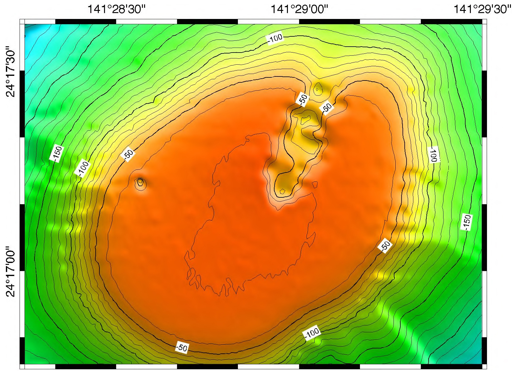
Source: Smithsonian Global Volcanism Program. The region within the -40m contour (the flat bit) is 1.2 km in diameter
Taking the bathymetry and overlaying the new island gives the following result. I tried to get the scale correct, but the precise position is not as certain. In fact I shifted the coordinates by 30 meters to avoid the new island going over the edge, and put the vent in the centre of the plateau. The precise PlanetScope coordinates would put the vent 30 meters further to the north-northeast, along the apparent rift. The steepness of the slope outside of the -50 contours makes it more difficult to create the new island at that location. The deep hole visible in the bathymetry near the western edge of the plateau now nicely coincides with the indentation of the island. A 30 meter error in the latitude coordinates of the bathymetry map is perhaps acceptable. However, this does not mean that my positioning is correct! Feel free to move the island around.
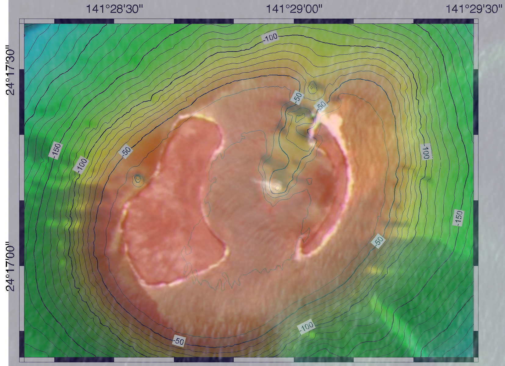
Overlay of Planetlab and bathymetry
The neighbourhood
This is clearly an impressive volcano, and a very active one. It is not huge. The ocean here is deep, 2 kilometers or more, but the volcano is sitting on a larger plateau which rises far above the deep sea floor. The base of the volcano is around 400 to 500 meter deep, and around 5 km in diameter. We are talking about a 5 km wide, 500 meter tall volcano with a 1-km flat top and a 500-meter rift running from the centre. Without wave erosion, we can estimate that the top would have been about 100 meter above sea level.
It is not the only volcano here. Just 4 kilometers away is Minami iwojima, a steep extinct cone reaching a height of 900 meters above sea. It dwarfs our exploder.
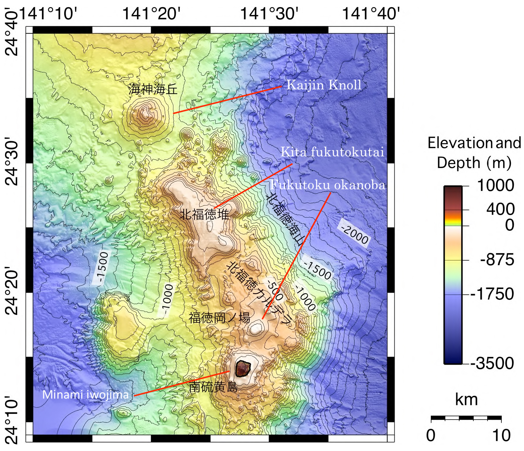
The map shows the underwater view. There is a 25-km long, bendy ridge with several distinct peaks. Minami iwojima is the dominant one, but there are three other named peaks, all of which reach to just below sea level. Wave erosion has gotten the better of all of them. Only Fututoku okanoba appears active. There are a few other, unnamed peaks, and to the west is a larger flat-topped ridge which is 700 meters below sea level: the depth suggests this ridge has suffered subsidence.
Remember that rift in the summit of Fukutoku okanoba? Extend it the other way, and it points directly at the extinct cone of Minami iwojima. Our volcano is either a satellite of Minami iwojima, or its structure has a fault caused by it.
The arc of the Volcano Islands
The two islands are part of a larger volcanic region. These are the well-named ‘Volcano Islands’. There are four – now, temporarily, five – islands forming a 500-km long but sparsely populated chain. The chain runs from 800 km to 1300 km south of Tokyo.

The five islands are Minami iwojima, Fukutoku okanoba, Iwo Jima, Kita iwojima and Nishinoshima. Iwo Jima (renamed to Ioto in Japan) is 60 km north of Fukutoku okanoba, Kita iwojima lies 80 km further north, and finally Nishinoshima is 200 km further – a bit further but it seems to belong to the group. There are also more submarine volcanoes, about 500 meters below sea level: Minami hiyoshi, Nikko (about 50 and 100 km south of Minami iwojima), and three near Nishinoshima: Doyo seamount 50 km to its north, and Kikata and Kaitokyu seamounts 50 and 100 km to its south. Finally, there are some submarine vents near Kita iwojima. Together with the Volcano Islands, they form the central, active part of a 2000-km long series of volcanoes (many of them submarine) stretching from Japan to the Mariana Islands, with volcanoes typically 50-60 km apart.

There is a second string of islands 100 km to the east, with as largest one Chichijima. These are called the Bonin islands (meaning ‘uninhabited’ which is no longer fully correct). The term Osagawara islands is also used for these islands.
Of the Volcano Islands, Minami iwojima and Kita iwojima are quite similar to each other. Both are steep cones of similar height (913 and 792 meters) and size (2 km across), have sea cliffs of several hundred meters tall, lack any sign of current activity (no fumaroles or hot springs) or recent eruptions. Both consist of tholeitic basalt as expected of oceanics arcs: they are extinct tholeitic stratovolcanoes. The ages are not known, but may be as much as a few hundred thousand years. If they are old, they may have originally formed as submarine volcanoes and reached their current height by uplift. However, this is speculative.
The other three islands are lower, lie just below or above sea level, are flat-topped, highly active with vents and frequent eruptions, and have alkaline lavas which are indistinguishable between Iwo Jima and Fukutoku okanoba. Nishinoshima also erupts alkaline lava but of a slightly different composition. Nishinoshima had a long lasting eruption from 2013-2020, 40 years after the previous eruption, which made the island much larger. The original island has been above sea level since at least the 16th century. Iwo Jima shows phreatic eruptions with active fumaroles, and has been inflating for hundreds of years at typical rates of 2 meters per decade. It had a significant eruption perhaps 2500 years ago. Fukutoku okanoba erupts every few decades, at times forming an ephemeral island. The new volcanoes are very different from the previous cones. There has been a change of the guard, out with the old and in with the new.
What is going on? And why are these volcanoes here, in the middle of the ocean? For that, we need to get to the bottom.
The Battle for the Pacific
The Pacific Ocean has a violent temper. Above, there are the frequent typhoons which are probably the main reason that the Volcanic Islands find it so hard to grow up. Underneath, it is fighting for supremacy with smaller plates all around the ocean. One of those battles is taking place near the Volcanic Islands. And this battle is not going well for the Pacific plate.
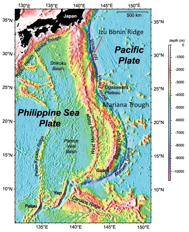
The Pacific plate covers much of the Pacific ocean. It is an old plate which has ruled its kingdom for a long time and does not take kindly to competition. But new plates are growing, younger and hotter and more nimble. The Pacific plate is being challenged. In this particular region, the challenger is the Philippine sea plate. It is still young(ish) but already heavily scarred by the conflict. From west to east, we find the Palau Kyushu Ridge (known, obviously, for Palau), a wide basin called the Parece Vela basin in the south and the Shikoku Basin in the north, the West Mariana Ridge which becomes the Izu Bonin Arc further north, another basin, the Mariana Trough, which is in the south but with a similar smaller basin in the north called the Ogasawara Trough, the Mariana Ridge (home of Guam), and finally a deep trench, called the Mariana Trench in the south and the Izu Bonin (or Izu Osagawara) Trench in the north. This trench is the boundary between the Philippine and the Pacific plate. This is where the Pacific plate is subdued by the challenger.
Subduction and roll-back
In this region the ocean floor of the Pacific plate is around 150 million year old. The Philippine plate has a variety of ages, but in this area is typically 50 million years old. The Pacific plate is much older and therefore colder and denser, and in the collision zone it is the one to subduct. Old crust, once subducting, sinks steeply. This causes all kinds of problems at the surface.

Nyu et al. https://yaolingniu.webspace.durham.ac.uk/wp-content/uploads/sites/234/2021/04/2014Niu-GTM.pdf
The cartoon illustrates the process. The red bar is the Pacific plate, and grey plays the part of the Philippine sea plate. T1, T2 and T3 are three different times. Over time, more of the Pacific plate begins to subduct, and the location where the sinking begins is moving backward. This leaves a gap, and the Philippine has to move in to fill the gap. Near the boundary between the plates a ridge develops: an arc. In front of the arc is the trench formed by the sinking plate. Behind the arc, the plate is stretching and thinning in order to be able to fill the extra space. This forms a basin.
Why the backward movement of the trench? This is because the sinking plate is down the creek with a paddle. Initially, the subduction is fairly shallow. But over time it becomes steeper. The subducted slab is now moving downward and backward, like a paddle moving through the upper mantle. The mantle underneath the Philippine plate has to move forward to fill the vacuum created by the paddling plate, and it pulls the Philippine plate with it: it is sucked forward. The trench begins to move backward.

This steepening is very notable along the Izu Bonin Trench, where the angle has reached 55 degrees, and even more so along the Mariana Trench where the Pacific plate descends almost vertically.
The paddling causes the trench to retreat. The Philippine plate now has to fill more space. That is fine if there is a spreading centre creating more crust, but when there isn’t one, the extra space is filled instead by thinning of the crust. The thinning crust sinks and a basin forms. Below the thin crust, the magma can circulate up and a weak spreading centre may form.
Basins and Ridges
This happened in the Philippine sea plate 30 milion years ago: it formed the Parece Vela Basin in the south and a little latter the Shikoku Basin in the north. But the basins eventually ran out of magma and spreading here ceased 15 million years ago. So the process repeated, and around 7 million years ago the Mariana basin began to form, closer to the front. At the moment this basin is 1000 km long and 200 km wide; it is widening by 2 to 4 cm per year. Further north no new basin has formed (so far, at least). The Philippine sea plate has a bit of clockwise rotation, and it is pulling away a bit from the Pacific plate in the southern region. This has made the whole process faster in the south. The Mariana Trough has become so pronounced that it is sometimes considered as its own micro plate, and the adjoining trench, the world famous Mariana trench, now contains the deepest surface on Earth. As Bond would say, straight down, with a twist.
The Philippine sea plate is a mosaic of ridges and basins. The ridges are (or were) volcanic arcs. They formed in the usual way: once the subducted plate reaches a certain depth it will begin to melt. The melt percolates up and forms a chain of volcanic islands, typically 50-200 km from the plate boundary. The basin forms adjacent to the trench, in between the volcanic arc and the plate boundary. Every time a basin forms, the volcanic chain begins to move away from the plate boundary and the volcanoes become extinct. This has happened to the Kyushu-Palau Ridge which became extinct 25 million years ago, and to the West Mariana Ridge 7 million years ago. A new volcanic arc will form, at first widening the existing arc and later as a separate arc. The spreading centre moves away from the subduction front as the crust stretches, and once it has moved far enough that the volcanic islands form between the spreading centre and the front, they can grow in one location. This can take a few million years. The Mariana Ridge has formed such a new volcanic arc. The Izu Bonin Ridge has not yet done so.
There is another process to consider. A ridge can also build up adjacent to the trench, pushed up by the collision with the subducting plate. Behind it, the descending plate can pull the overriding plate down, causing a trough in front of the volcanic arc. The pushed-up ridge is the forearc, and the trough is known as the forearc basin. There is one such basin in our area: the Ogasawara Trough. The Volcano Islands are one the west side of this trough, and they form the volcanic arc. The Bonin Islands are on the other side, on the pushed-up ridge next to the trench. The Bonin Islands are not volcanic, although like all ocean floor, they are created from lava.
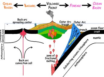
forearc and forearc basin. Source: Wikipedia
When looking are the mosaic of ridge across the Philippine sea plate, it is worth remembering that originally there was just one ridge, but every time a basin formed in front of it, eventually a new volcanic ridge had to form.
The subducted plate consists of normal oceanic crust. When it melts during the subduction, it forms thoelitic basalt (a mafic mantle melt). This is the type of basalt found on the two extinct stratovolcanoes in the Volcano Island chain, and widely elsewhere along the volcanic arc. But why does Fukutoku okanoba have a different lava, even though it is next to the tholeitic (and extinct) Minami iwojima? And why is this same lava found on Iwo Jima – and nowhere else?
Shoshonites
The lavas of Fukutoku okanoba are alkaline (not mafic) with an SiO content of 60%, high potassium and sodium (9% together), and low calcium and magnesium. They are so-called ‘alkaline shoshonitic lavas’, and the area where they are found is called the ‘alkalic volcano province’ – it coincides with the Volcanic Islands.
The name may need some explaining. Shoshonite is a type of rock: a potassium rich, basaltic trachyandesite. Its name comes from the Shoshone river in Wyoming, after this type of rock was identified in Yellowstone. Trachyandesite is a rock with about 60% SiO2 and about 9% K2O+Na2O, low in magnesium and iron. ‘Basaltic’ means it was erupted effusively (normally with low viscosity) and cooled rapidly at the surface; basalt has a bit lower SiO2 (less than 53%) so this is ‘basaltic’ rather than ‘basalt’. Shoshonite is present at Fukutoku okanoba and at Iwo Jima. Nishinoshima has similar lava but it has less potassium and a bit more magnesium and iron: it is an intermediate between typical arc lavas and the stuff found at Fukutoku okanoba.
It is still a bit of a mystery why this particular region has this peculiar lava. It is a recent change, because the extinct stratovolcanoes here show normal lavas. Something has changed.
Shoshonite is found at the Hiyoshi submarine volcano at 23 degrees north, at Fukutoku okanoba, and at Iwo Jima at 24.8 degrees, with a transition zone to Nishinoshima further north. This is precisely the region north of the Mariana Trough. The oldest shoshonites are found in the south, adjacent to the Mariana Trough, dated to 3-4 million years ago, while the youngest are obviously from the two currently active volcanoes further north. It is tempting to link this to the northward spreading of the Mariana Trough. The trough is a few million years older than the oldest shoshonites. Is this the delay between spreading and the formation of a new volcanic arc? Is the region of the Volcanic Islands getting ready to join the Mariana Trough?
A change of melt
It is not immediately clear why basin formation would change the composition of the magma. Neither is it clear why the volcanoes are at sea level (with possible uplift) if a basin would be forming. Is there an alternative explanation?
If a small spreading centre is forming, the mantle heat may recently have increased, and caused some uplift. Volcanic arcs form from melt of the subducted plate. If there is more heat, there may now be a partial melt of the wedge between the subducted plate and the Philippine plate. The alkaline lava suggests a low melt fraction.
Here the forearc trough comes into view. The Volcanic Islands are along this basin: can this be part of the problem? The forearc basin is pulled down by friction with the subducting plate. Erosion can occur: material is pulled off the bottom of the Philippine plate and carried backward by the descending plate, enriching the mantle material in this wedge. This could explains some chemical peculiarities. The change of melt source must have occurred recently, over a 200-km long arc. This makes an origin in the Osagawara forearc basin plausible. But the true source of the shoshonitic lavas remains an unsolved problem, somehow related to the battle of the plates.
Shoshonitic lava can form when oceanic magma crystallizes at higher than usual pressure. Either olivine or orthopyroxene can crystallize, depending on how much water there is in the rock. If wet, olivine forms which increases the potassium and silicate in the remaining melt. Shoshonitic lavas are found in different locations. Some are associated with a continental margin, related to crustal thickening. This is seen for instance in the Andes, Kamchatka, or the Eolian arc north of Etna. The high pressure at the base of the thickened crust causes the shoshonite to form. The second location is in island arcs which are becoming unstable, for instance when subduction is ceasing or changing direction. They appear to be a late phase in the evolution of an island arc, perhaps related to a deepening of the subduction melt.
Perhaps the paddling movement of the subducting plate is making it deeper, with the melt now forming deeper and at higher pressure. A second possibility is that spreading is indeed taking place, move the current volcanic islands further from the subduction zone, and therefore higher above the subducting plate. Perhaps the forearc basin is beginning to become a spreading basin taking up the retreat of the subduction front and the Volcanic Islands will have to move east, until they pass the new spreading centre and find a new stable location – forming a new volcanic arc, with the current arc becoming one more scar on the Philippine plate.
Speculating further, why have Fukutuko okanoba and Iwo Jima become so active? The removal of olivine from the melt may make it more buoyant, causing the residual melt to rapidly rise into much shallower magma chambers. The amount of magma may not be as high, especially if the arc is beginning to be starved of magma, but what is there would reach the surface easily and regularly giving frequent but smaller eruptions. As happened this month.
If any of this speculation is correct, changes are afoot in the Volcanic Islands, perhaps as soon as in the next hundred thousand years. Keep posted.
VC has long been fascinated by Iwo Jima (Ioto) and its extreme inflation. Now we have seen its sibling erupt. These volcanoes may or may not be tracing the beginning of a rift, which will eventually extend the Mariana Trough. Either way, it is all part of the battle for Pacific supremacy between the ancient Pacific plate, ruler of all, and the upstart (now middle aged) in the west. Our volcanoes are driven by events outside of their control, and their eruptions are collateral damage in a titanic battle. We might call that friendly fire.
Albert,August 2021


As requested, a non-Icelandic post. And we even managed to sneak in Etna
Lovely read, learned a lot as a volcano/geology neophyte (always been interested but not really learned the details). Thank you Alfred!
Thanks Albert! Such a complex region!
Thanks Albert – and good to get some diversity in VolcanoLand
Good stuff Albert.
With the contour map flattening out at -40m, i assume this submarine peak (and many of the others) would have been well above sea level during the last and previous ice ages? Or has it built up to this level as the sea level rises?
I’m also guessing 40m is probably the depth that wave erosion is no longer any issue?
It is about the maximum depth that wave erosion can reach. Yes, during the ice the wave erosion would have acted much lower. There is no sign of a plateau at the -100 m level, so the current peak has build up after the ice age. Iwo Jima does show a hint of a plateau and steep sides at -100 to -150 m levels, and that could be an ice age reminder, with the central part of the island have build up since.
Well writ as usual. Many thanks.
Is the mechanism that created the Palau-Kyushu & West Mariana ridges the same that created the Chagos-Laccadive ridge/Ninety-East ridges in the Indian Ocean? They are magmatic in product but tend to lack volcanic structures, and the hotspot trail from Deccan doesn’t really add up all that well (at least not for all of it).
Chagos is usually attributed to Reunion (Deccan) hotspot while Ninety-East ridge with Kergeulen hotspot and opening of Indian ocean.
Interesting swarm at Grímsvötn. Is it time?
Thanks for the article. That explains why that area has all those long, parallel arcs. And a nice mystery in the changing chemical composition of the magma!
Thank you Albert. I find this chain of islands very interesting, along with the rest of the Western Pacific.
Thank you for this great article! 🙂
Is roll back what’s happening between the Pacific coast and Nevada? At least, in the past?
The Sierra Nevada mountains contain granite batholiths from what was a subduction zone, when the Farallon plate went under the North American plate.
https://en.wikipedia.org/wiki/Nevadan_orogeny
But interesting point, because you have a stretch/extension zone (basin and range) behind a plate boundary.
Also interesting (to me, at least) is that north of the Mendocino triple junction, you still have subduction and a volcanic arc, but south of that, not anymore.
I missed the entire previous episode, Fagrahraun is ramping up to the next one now, and I still cannot find any working live cameras at Youtube.
It seems there’s been some kind of policy shift regarding how public this eruption is. Why? And how do I get them to reverse course on this and have things back the way they were a few days ago?
IT IS FOG…
I dont know why you dont get this.
Fog would cause the RUV camera to be blank black?
It will if it is at night and the eruption hasnt reached full intensity yet. Even at full force it will barely show any glow through the fog at that distance.
Usually blank black is a camera malfunction on that one.
And where are all of the others? I can’t find any other live cams. The MBL page someone linked to that listed their cameras no longer does. I can’t find any with Youtube search. It’s almost as if that single RUV camera is the only one.
MBI probably just couldnt host their livestreams anymore, they have lost two cameras and kept the thing going non stop for months, that is very expensive, and they werent getting any ad revenue on youtube. Their streams are available I think elsewhere though I havent tried to find them yet.
OK, since it seems the point is being missed somewhere, maybe I should just directly ask:
How do I get a view of the upcoming eruptive episode?
The best way currently is through the still cameras. They obviously don’t show the bubbling, but they show the lava streams well enough. Assuming the fog lifts, the wind returns, and the power turns back on. It was commented here that they run of solar power and the fog may be forcing them to run on battery power
Presently: https://www.youtube.com/watch?v=okxu-E760ao
You don’t. It’s foggy. The RÚV one works and gives an accurate picture of what the scene currently looks like. The close-up cams are on a hill surrounded by lava and only accessible by helicopter. I don’t think they will send someone there to fix them before the weather conditions allow. Just be patient.
Why would there be a conspiracy to prevent people from watching the eruption? What would anyone gain from that? There is not some massively funded Iceland Volcano Network News. The best way to see the eruption is to go to the Eruption in person and look at it. Otherwise you and everyone else is at the mercy of the weather. I will be THANKFUL when the weather improves and we are able to see the eruption again on our screens FOR FREE.
Just a hunch here, but policy (of the camera operators) might IMHO be a factor. The cameras operate on solar and battery (I think), so IMHO it would make sense for the camera operators to put the camera in standby when there’s no picture to transmit, especially when the weather has prevented the solar arrays being of much use.
I also suspect that the loss of “telemetry hill” and its wind turbine impacted both connectivity and power supply options in the area.
Twisted One, take a chill pill!
1) It’s worth remembering that way to winter now. So far we’ve a lot of daylight over the Iceland summer. We now have darkness when we haven’t for a few months. Give it another couple of months and there won’t be might daylight at all. That means less time for solar panels to charge. Time to get ready for lots of black screens, because we won’t be able to tell if it’s because the camera is off or because the clouds are blocking the view.
2) Iceland is not a tropical island. It has clouds and fog and rain regularly, this is going to block the view and no one can do anything about it. This also will stop solar panels charging, so the worse the weather, the less time the cameras will be active. Oh and as summer is ended, expect more of the bad weather too. We’ve been quite lucky over the summer to see as much as we have.
3) the cameras are not a public service, no one has an obligation to stream anything. They can only be reached when the weather is good enough, the people have time to go and there is money to maintain them. If they all happen to go off line together, then that is just our bad luck. We should be grateful for what we do have.
4) there may be people from Iceland who work with the cameras reading your complaints, after all this is a public website. How do you think they would take your comments?
So please limit the complaints, it’s starting to get a bit repetitive and boring now.
5) Also the emergency services and volcanologists use the webcams to monitor the eruption. The camera providers know this and work hard to keep the cameras going. The eruption is benign at the moment, and likely to remain so, but that could change e.g. if the crater collapses.
Kilauea starting to swarm again, after sleeping for the last week. Maybe 3rd time lucky… 🙂
After watching this for a while now I think this was another failed eruption like what happened back in early December last year. There is an ongoing swarm of quakes along the south ring fault and the sand hill tiltmeter has just shot up by nearly 10 microradians. Unfortunately theres no other tiltmeters nearby that work and the GPS has been offline on the whole site for a while now, a problem with the servers it seems.
Still, looks pretty conclusive, and it is still going so as yet might be a bit premature to say it failed…
There is a most unusual earthquake swarm going on since 00:13 UTC this morning. The activity has affected the upper portion of the Southwest Rift Zone connector conduit, but it is not the typical swarm in the connectors which occur when Kilauea inflates, which currently is not doing so, and affect also the summit caldera and the East Rift Zone connector conduit, which seem quiet at present.
I do not quite know what is going on with this swarm, it doesn’t look like a magma intrusion to me since the UWE tiltmeter shows nothing special and the seismograms do not show anything that could be linked to magma movement. But given its location and the earthquake distribution in time, which is volcano tectonic, then chances are it is somehow related to the magma processes in the volcano.
Come to think of it the volcano has been a bit weird since the 10th or so, when they was an odd deflation similar to that of DI events but which wasn’t corresponded by any inflation. There was also a weird earthquake swarm under Kilauea iki. Since then the supply to the volcano looks somewhat stunted. What are you up to Kilauea? I wish I knew.
https://www.usgs.gov/volcanoes/kilauea/monitoring
I just noticed that the SDH tiltmeter does show a rapid inflation coming from the swarm of earthquakes and at the right time. There must be magma in the move. This is either a magma intrusion or a DID event. The strange thing is that the UWE tiltmeter does not show anything. which means that the magma chamber of Kilauea has still not gotten involved in this intrusion or whatever is going on.
A DID, deflation-inflation-deflation, event is a rare type of DI event that produces a powerful spike in inflation which is then rapidly undone. In the past these events have flared up the East Rift Zone conduit with earthquakes and caused eruption surges from Pu’u’o’o. This could be a DID event that has targeted only the Southwest Rift conduit, pushing magma into it.
A magma intrusion is perhaps more likely though, because never before have the connector conduits produced detectable inflation signals, or at least as far as I know. So most likely a sill or dyke has started growing in the vicinity of the connector conduit.
Or perhaps it is something different altogether.
Does seem a strange time to erupt, with no immediate fast inflation, but all this is on very short timescales too and on longer term there is pronounced and pretty much uninterupted inflation, it could be related to that in a more general sense. At this rate though we will find out soon, perhaps very soon.
This reminds me a lot of the (relatively) long precursor to 1959, much longer than the <1 hour warning for Halemaumau or any if the other magma chambers. This is maybe magma directly from the south caldera reservoir not a shallow chamber. Iexpect a firework show if this is the case 🙂
I think it is an intrusion or tectonic movement on the southwest rift. The fast but not instant tilt change on SDH suggest slow creep, where the earthquakes capture only part of the seismic energy
Now mag 3 quake just east and at same depth, a relatively big quake and one probably felt. Definitely something happening now
If it is a south caldera dike then it still might not erupt, the last such intrusion in December seems to have lacked the push to intersect the surface, and not much has changed since then. The December south caldera dike did however “announce” the Halema’uma’u dike later that month which did erupt. And this was not an isolated occurrence, in 1971 and 1974 there were south caldera eruptions which were then followed within 1-2 months by a Halema’uma’u eruption. In 1982 it was the opposite, there was a Halema’uma’u eruption followed by a south caldera eruption 5 months later. So it is interesting to note that this south caldera intrusion could be a precursor to a Halema’uma’u eruption later this year.
Perhaps it is too soon to be speculating so far ahead, but I couldn’t resist.
Interesting that the UWE tiltmeter, which is very well positioned to capture the inflation and deflation of the summit conduit and magma chamber of Halema’uma’u, shows some rapid variations occurring 2-4 times per day, up and down. This signal has been intensifying during the last week. I don’t know if it’s magmatic, or some sort of noise. I don’t remember seeing it before, but if it has happened before then I probably dismissed it as being noise.
What’s the current weather like there?
I’ve seen similar signals in the past, during periods of heavy rain. The rain eases up for a bit and the tilt goes down again as water drains away. The next squall comes through and it comes right back up.
Yes, it is raining, according to the weather radar. You must be right then. Thanks.
You would probably know better than me but it looks like this event is not fed from Halemaumau, which is why there was no signals on the main tilt. If the GPS was working I think it would show continued upward trend, especially the south caldera stations. Will be interesting to see what they look like after this when they update.
Seems a possible direct intrusion from the south caldera reservoir.
It’s just a possible explanation, but with what Kilauea is doing at the moment, it could indeed be something more.
On this today not very committal: HAWAIIAN VOLCANO OBSERVATORY INFORMATION STATEMENT
U.S. Geological Survey
Tuesday, August 24, 2021, 3:09 AM HST (Tuesday, August 24, 2021, 13:09 UTC)
USGS are, let’s say *risk-averse*.
Dont want to be taken by surprise again. Although if it was a mirror repeat of last year that still would have happened…
RE:”Dont want to be taken by surprise again. Although if it was a mirror repeat of last year that still would have happened…”
USGS couches their ‘risk averse’ language as such notwithstanding the fact that there are civilians employed and or residing in the summit area [Volcano House/Volcano Village and others] and, as you have previously observed with regard to time frames, one hour isn’t much time to evacuate the lot. If I read BillG’s ‘dot’s correctly, that’s SWRZ which has a history all its own.
The fact there is so much activity along the caldera ring faults after 2018 seems to me to suggest the faults are unstable and probably would have collapsed in 2018 if Ahu’aila’au was at a lower elevation. Probably in this state there is a real risk of a major collapse in the near future.
As previously noted in these pages…
Today’s swarm..

Regarding the visibility conditions in Reykjanes, here is a model prediction for the low level clouds in iceland until Thursday noon. White colors show dense low level cloud cover. As you can see, conditions are going to improve slowly. Also, it might still be possible to see the volcano on the webcam even if there are many low clouds, provided that the ceiling level (not depicted in the animation) is high.
Thanks! I’ve been checking the forecast for Grindavik here (nearest station I believe)
https://en.vedur.is/weather/forecasts/areas/faxafloi/#group=11&station=1361
Meteoblue meteograms are really good, I find, for getting a feel for how clear the weather will be. See link
https://www.meteoblue.com/en/weather/week/fagradalsfjall_iceland_3417487
And scroll down to the meteogram
Looks pretty grim for the whole of next week.
Alert level for Kilauea has been upgraded to orange.
RE:”Alert level for Kilauea has been upgraded to orange”
“Holy ‘hear what I color, not what I say,’ Batman!!”
The SDH tilt meter has now reached +20 microrad since the start of the swarm. Magma is on the move, I think. Although it may not be very much magma
swarm seems to be getting more intense and focussed. The individual events seem tectonic. It seems similar to the weeks before the Geldingadalir eruption
Now it’s past +30 microrad.

At https://hometravelz.de/fagradalsfjall-der-neue-vulkan-in-island/ “Fagradalsfjall – Der neue Vulkan in Island (Fagradalsfjall – The new volcano in Iceland)”.
Kīlauea volcano is not erupting. A swarm of earthquakes beneath the south part of Kīlauea caldera, within Hawaiʻi Volcanoes National Park, began on the evening of August 23, 2021. The swarm continues into the early morning hours of August 24 with a particularly strong sequence of earthquakes that occurred at about 1:30 a.m., HST. The onset of the earthquake swarm was coincident with a change in the style of ground deformation at tiltmeters in the Kīlauea summit region, potentially indicating the shallow movement of magma beneath the south part of Kīlauea caldera.
The US Geological Survey Hawaiian Volcano Observatory is raising the volcano alert level/aviation color code for Kīlauea from Advisory/Yellow to Watch/Orange due to this activity.
HVO will continue to monitor this activity closely and adjust the alert level accordingly.
HVO is in constant communication with Hawai‘i Volcanoes National Park as this situation evolves. The activity is confined entirely within the park.
Kilauea really chugging away.

SDH Tiltmeter.

Imagining the operator glancing over at that screen and going “Yikes!!!!”
Feed #1 and Feed #2 are back up at new Youtube locations.
https://www.youtube.com/watch?v=_CXkVzXFpiU
and
https://www.youtube.com/watch?v=okxu-E760ao
Feed #2 appears best for monitoring the filthy weather from at least 4 cameras at once, interspersed with a map and the FAF graphs.
Feed #2 is rotating between the cameras available at 15 locations at the Iceland volcano (about 7 or 8). The occasionally displayed map shows the location of 15 cameras.
The high pressure over the UK is set not to change much over the next 10 days or so according to the forecast, with the jetstream having a huge kink, heading almost north to Iceland. When this happens, Iceland gets all the bad weather instead of some of it heading towards the UK. A similar thing happened when I went to the Faroe Islands to see the solar eclipse, except the high was a bit further west, so the weather wasn’t as severe, just cloudy.
I used to have links to the various levels of cloud cover, I’ll see if I can find them, particuarly the low level cloud cover.
This model shows the cloud cover predictions for the next few days.
https://spakort.vedur.is/kort/ecm0125/2021/08/24/00/ecm0125_island_lcc_mcc_hcc.html
This one is a bit clearer to follow, the blue is the important one for viewing the eruption, although it will be worsened by the gas combining with the low cloud.
https://spakort.vedur.is/kort/ecm0125/2021/08/24/00/ecm0125_island_tcc_lcc_mcc_hcc.html
M5.1 in India looking like an underwater landslide.
Never mind the possible eruption, there is a rainbow in the crater!
Looks like the volcano is happy!
She is about to pass some gas!
Kilauea, 25 quakes in last half hour.
There is a significant chance that this will shortly end with an eruption
And still the Uwekahuna tiltmeter shows nothing, so weird. This magma intrusion is strange. Very different from the intrusions Kilauea had in December.
It is also outlining the upper southwest rift connector conduit which I don’t understand why. Sills and dykes run southwest-northeast following the direction of spreading. An intrusion should not be able to go in a north-south direction along the connector conduit. And if anything happens on the volcano the Uwekahuna tiltmeter should be the first place to show.
I don’t know what to expect out of this situation.
It’s almost as if the magma’s intruding into a pile of gravel. No coherence at all. Maybe the 2018 collapse ‘loosened’ things up. That might explain the lack of tilt.
First ever radial eruption from Kilauea? 🙂
Probably not but it seems this is quite new, not just a bog standard magmatic event.
I am expecting if this does erupt it will be very hot and gas rich, so potentially some big fountains or a very fast flow, if it is not tiny that is. It looks like the intrusion is following the ring fault west of Halemaumau but then leaves the caldera, it could be a lot bigger than we think. Really if this magma has bypassed the Halemaumau chamber the chance of it erupting is high, and the elevation of the terrain above it will not really be importtant. Seems very like 1959, LERZ eruption followed a few years later by a powerful summit eruption, and then of course another bigger LERZ eruption. Second part is obviously speculative now but cant ignore it…
What puzzles me is that if it was an intrusion then it should have extracted magma from the under caldera and caused rapid deflation at UWE and IKI tiltmeters. The December intrusions for example showed very well in all working summit tiltmeters, as either inflation or deflation, depending on whether they caught mainly the dike signal, or the summit storage signal. But UWE and IKI are eerily silent now, despite all the commotion in the south caldera. Only SDH shows deformation, inflation, and now it also looks like the slope has started to go and up down rapidly as if the ground as SDH was shaking, or something similar.
Kilauea throwing a deep eccentric eruption, bypassing all of the storage. I think the shaking must be a big sign if it is making the signal vibrate to that degree.
The earthquakes are affecting some of the areas that were active early this month when Kilauea was inflating and pushing against the walls of the magma chambers and the two conduits that branch from it. Although the current swarm only affects a small portion, the part where the southwest rift connector branches from the magma chamber. The area of OUTL station, the small cluster of quakes at CRIM station, and the ones in the west side of Halema’uma’u where areas activated early this month as well as now.
I drew on this map the structure of the conduit and magma chamber when Kilauea was inflating earlier this month:
The RUV Fog-Cam has turned a lurid bright red. Has Geldingadalir blown up?
Or someone in a red coat is stood in front of it :P.
Where’s the Nátthagi webcam when you need it?
Lava flowing into Nátthagi
Source for image of Geldingadalir: https://www.youtube.com/watch?v=BA-9QzIcr3c
Earlier shot from the same source looking down into Nátthagi:
Every time I look at the HVO quake map it has even more red dots on it, and a lot of bigger ones. Not actually big earthquakes but surely if you layed on the ground at the Keanakako’i overlook you would be able to feel or hear it.
Send me Kilaūea stations drumplots
Is the intrusion still going ?
Yes it is ongoing, seems to go in pulses. Plots are on https://www.usgs.gov/volcanoes/kilauea/monitoring#
Even if there isnt an eruption now this is going to be a place to watch. Definitely more magma involved than the intrusions last December, though there is no rifting so I dont know why it hasnt broken through yet.
What about the second location of earthquakes near the coast? What does this mean?
Near Pahala? No one really knows for sure but it is generally believed to be a source to Kilauea, though probably not the only one. It isnt completely correlated to eruptions though, more to long term trends it seems.
They are all deep…probably where the plume source for Kilahuea encounters brittle crust?
If it erupts it coud perhaps become an event like 1974 but perhaps even bigger
1974 was awsome and really runny so fluid it made sheet pahoehoes flows a centimeter thick in the caldera, and really was a mini flood basalt.. it flowed very quickly
1974 was Probaly the same magma as the 2008 – 2018 overflook lake I think
2021 was a bit cooler But still very very fluid and hot
1974 could have been much bigger, it was a major intrusion the biggest at that point since 1960, the eruption was only a very small part. The eruption lasted 6 hours, the intrusion lasted over a week, at a rate of 1.2 million m3/hr the intrusion could have had 0.2 km3 or over 1 year of magma in it. I actually dont know how it didnt erupt further down, maybe I am way overestimating the volume, but the eruption in any case was just a small part.
Had the magma all erupted, it would have been possibly as big as Mauna Ulu, or 1960. Even something like 1959 which was 1/3 that size is a huge eruption, if that was erupted really fast it would reach the ocean.
Significant drop in tilt on the SDH instrument. Nothing to see on webcams. Hmmm.
It is actually not a dip, the area was shaken by something and it has gone back up to where it was before, maybe with a slowing of tilt. One of those quakes must have been very shallow as none are big. The biggest quake of the swarm was a 3.0 and just a few hundred meters below the surface at Halemaumau, about a day ago. That might have done it.
I’ve seen in the Swarm software, and with OTLD station data, that there are VLP earthquakes occurring. The ground moves like a wave lasting several minutes. Usually the wave starts abruptly and then fades much more slowly. Some of these can also be seen in the OTLD station in HVO’s page, that is why the the seismograms look so weird, they show oscillations of the ground lasting up to 15 minutes in some. Some of the very long period earthquakes must have affected the SDH tiltmeter by changing the slope of the ground for minutes-long periods of time.
I have counted 17 VLP earthquakes, this is quite spectacular, in the previous 3 years I have only seen Kilauea do a few isolated VLPs, during magma intrusions.
Short-lived downward spike. It normally signals a nearby shallow earthquake
Yep, some kind of transient event. All I could see at the time was that sharp down spike, and I got excited, Kilauea teasing me.
It did actually change the tilt: the SDH (sandhill) measurement towards the caldera became flat, while the direction towards the rift kept increasing. This may be a fault in the measuring or a real change in the magma flow. The GPS measurements have been updated today: they stopped a week or two ago but now are up to date again. Strong inflation south of the caldera continued. The horizontal displacement have a problem with some data that is 1 meter off but the vertical data is good.
Meanwhile in Iceland, efforts to wrestle the Lava continue…: https://m.youtube.com/watch?v=AtyVhmTPA_M
But I think whoever did this was not doing a smart thing, as they collapsed the big tube going down into Natthagi. This will lead to lava resuming surface flow in that area once it gets there again. And that will lead to build-up that will quite quickly (due to diagonal flow on the steep slope towards the right) allow overtopping of the protection wall for natthagikriki.
The only thing to stop that is the fact that the lava might go down to natthagi for a long this me through the theater hill gap, and down a new pathway about to open between the two, once the level rises by five feet or so.
Of course, at that current rate of only a small fraction of lava going into Galdingadalir this problem is months away. But that small fraction can become a large one any time.
I meant: might go down towards Natthagi *for a long time* through the other path(s) before seriously resuming that far-end-pathway. Darn autocorrect.
Gutn Tog does get easily distracted in his videos…
RE:”Gutn Tog does get easily distracted in his videos…”
Too much motion in his video captures. Dizzy watching it.
i like his videos… he ususally covers what i’d look at if i was actually there.
RE:” i like his videos… he usually covers what i’d look at if i was actually there…”\
No argument there. More steady and more focused would greatly improve his coverage, whoever is handling the equipment.
Tilt at Kilauea’s summit down quickly last night. Looks like the quakes may have opened up some pathways to send (some of?) the recently emplaced magma off into the system somewhere. It’s fascinating to me how much shield volcanoes are like anthills – there are labyrinths of pathways through them like swiss cheese! Yes, there are superhighways (rift zones), but there are a lot of places for magma to “hide” and build up. One can even see this with the Iceland volcano – how many lava paths have we seen form, be abandoned, and then be used again? Too cool!
Looking around Hawaii and Mauna Loa, it is interesting to compare this scene with the outpourings of the Geldingadalir volcano:
It’s The Middle Part of Mauna Loa’s Southwest Rift Zone.
Basalt is going to basalt.
Is that lava showing on camera 1 below the Natthagi dam?
Looks like a red glow emerging from the fog, and tremor is on the rise.
Ok, maybe hallucinating in the fog. Could have been torches….
Tremor now passing 5k, and the only live camera I could find, which spent the day uselessly staring at some small pile of rocks, has finally changed state. Did they aim it at the cone? Oh, no, of course not! Instead, they switched it off!
It seems as if there’s no longer any real serious effort being made to broadcast the events at the volcano. Previously, when cameras failed it took them a day or two at most to restore them. Now they seem to just abandon them, save for that one RUV camera, and that one has been working only intermittently, and never showing anything interesting, for the better part of a week now. QoS, such as it was, has dropped off a cliff this week.
I’m starting to doubt we’ll ever have a live view of this eruption again. The various camera operators all seem to have tired of it and are just phoning it in at this point — well, aside from MBL, who seem to have just quit outright.
This is infuriating. It’s like finding a cool new book to read, only to discover that just as the plot is getting really involved, the story just stops at the end of some chapter and the entire rest of the book is just blank pages, not even because the author lost interest halfway through writing it, but because the publisher lost interest halfway through publishing it. We’ll never know how it ends, just that it has, one day when the tremor flatlines. What’s the eventual fate of the coast road, or of the “drinking stone”? Will lava escape Meradalir to the east? No way of knowing, because page 283 is blank. For all I know the coast road got overrun yesterday. With even the Nátthagi cam now having been shut down, who can tell? 🙁
***#*#**!+#**$** and #**#*1!!!#+*.
If you are coming on here to complain just to get a reaction congratulations you got one but you will probably get banned if you keep this up.
Theres no obligation to do any of this, and Iceland is not the best place in the world for both solar and Li-ion technology to work at their optimum. I also am not aware of a single instance the webcam has actually turned off for no reason, fog at night is very opaque. I expect in person you can actually see the volcano through it but the camera has not got that sensitivity, it focusses on the fog. Even in the dark you can see the screen is slightly animated, the fog blowing around.
Correction you will get banned
RE:” in response to Twisted One:..”
Winter is coming!! Count on not seeing anything until Spring.
You know what’s infuriating? Your comments. All you do is complain about the webcams being down and rant about how it’s all some kind of whacko conspiracy. Seriously. Knock it off.
Twisted one-there is an excellent book that toys with your conceit of a malpublished book-“if on a winter’s night a traveller” by Italo Calvino.
Next time the camera’s don’t fit your every whim and demand i suggest you pick it up.
Dear Twisted one
Can we kindly ask you to comment on the eruption without complaining about the people behind the cameras? We all would prefer clear skies and working cameras, but they are a gift not a right. The people installing, maintaining and operating the cameras have done an amazing job. There has never been better viewing of an eruption that I am aware off, and it is thanks to their efforts. A bit of grumbling is allowed, but continuously sniping at those people is not appreciated. I would prefer not to get one of our more ferocious dragons involved.
Now the people using their bums to obliterate the eruption, or endangering our mental health by throwing walking poles at the viewers, that is a different matter..
Is there tremor at Kilauea? The swarm seems to have died down but the lines on the seismometer are much more ‘fuzzy’ than before, which I recall was the case back earlier in the year when the eruption was ongoing. Except theres no lava anywhere.
Seems to me this is not over.
Inflation seems to be flattening out too.
Yep, flattening out. However something still thrashing around in the basement.
Looks to me like it is over, I don’t see any tremor. Whatever happened. which I’m still quite confused about it, must be something “new” that hasn’t been observed in Kilauea before. Perhaps it is related to DI and DID events but is not the same. Looks like UWE shows a little, slow deflation at the end of the swarm, like it does during DI events. The deflation of UWE starts after the main VLP earthquakes, which are visible in the tilt as punctual drops. So it looks like the unrest has ended with the slight deflation of Kilauea’s magma chamber. I doubt this was any attempt at erupting but rather something else. Kilauea is magming.
https://www.usgs.gov/volcanoes/kilauea/deformation-data
The swarm has clearly been related to the Southwest Rift Zone’s connector conduit, since it has flared up the same N-S line that shows earthquakes whenever Kilauea inflates. Nowadays most earthquakes during times of inflation affect the East Rift connector instead, while the southwest rift connector is only faintly visible. In the past, in the 1970s for example, the East Rift connector was shorter, and the Southwest Rift connector was longer, back then they did show activity on more equal levels.
I have been thinking this was a strange event too, and probably has not done anything to stop the next eruption, maybe put it off a day or two.
1970s the SWRZ did erupt twice, and 1974 was amajor event. The quake of 1975 I think opened up the ERZ a lot while not doing anything to the SWRZ so magma favored that direction for a long time. 2018 might have stayed a smaller eruption and Pu’u O’o reactivated, but the big quake in 2018 and high magma pressure saw the flank slip and a hydraulic connection between the summit and Heiheiahulu magma body feeding 2018, obviously we all know the result of that now…
The swarm recently might suggest a possible return to eruptions on the SWRZ, not exclusively, but possibly more than it has been recently.
There is some tremor again. It is not quite over yet. The quakes are shallower near the caldera and a bit deeper further along the conduit. The OUTL GPS stopped moving south during this event. I think some of the pressure associated with inflation in the southern part of the caldera was relieved in this event. It caused movement along the radial fault. That also allowed some magma to flow but that came later, after the fault had unlocked. I don’t think a dike formed, because the quakes are deeper further from the caldera. However, that could easily still happen.
Where, is the best location to get the very latest updates about Hawaii?
I look at https://www.usgs.gov/volcanoes/kilauea/volcano-updates, and also the Doing Hawaii Youtube channel https://www.youtube.com/watch?v=JMmk6qXgZJE which rotates through lots of information.
The Hawaii Tracker (a local organisation galvanised by the 2018 eruption) has regular bulletins on the situation, with public outreach videos by an ex-HVO geologist.
RE:”Where, is the best location to get the very latest updates about Hawaii?”
You can also place yourself on the HVO mailing list for updates. They were quite regular during 2018 and 2020-21..
Well, we;re in another eruptive phase in Iceland that we can’t see (other than a red glow) thanks to the low clouds.
Obviously, the low clouds (fog) make it impossible to get anyone to “theater hill” to service the cams there (new batteries, etc) because the only access to it is via helicopter, which the fog makes impossible.
As for other sites, I can certainly see why they’d be reluctant to send people out in bad weather. I know I wouldn’t like that job!
I am, though, very much looking forward to the first live (or drone) shots once the weather clears. I suspect we’ll see changes at the cone, as it’s had several unobserved eruptive cycles.
BTW, in case anyone is unawares what was being done in the area covered by the second RUV cam, “below Borgarfjall”, the Nátthagi valley, it’s at least in part an experiment; they are burying cables and test means of protecting them. (kind of like they did at the first berm, which got overrun). This indicates to me that they are expecting (as has been said in the past) lava to enter that area.
https://icelandmonitor.mbl.is/news/news/2021/08/20/eagerly_waiting_for_lava_flow_to_provide_answers/
I have been checking out the webcam here https://www.youtube.com/watch?v=BA-9QzIcr3c and there have been brief glimpses of the flow around 00:43 and 01:00, and 01:18, and it looks like a serious flow tonight! It will be very cool to see how the cone has changed once the fog and clouds lift.
I saw that too at 01:29. Strong flow heading towards (I think) the overtopped eastern wall above Natthagi valley.
Around 4:13 the clouds and fog finally lifted enough to see the crater again. The camera is pretty zoomed out but there are some moments of huge fountaining, and the left side of the crater still has lava pouring over.
What a beautiful site to behold- in full flow and over flowing -am amazed how the lava flows change direction every other day-I guess that’s what shield volcano building do!
The MET time-lapse camera for Meradalir, from 04:40 to at least 05:00, 2021-08-26, shows that all of the lava currently is flowing toward Natthagi.
Impressive, to me, a river of fire was revealed this morning with the weather clearing. I’d love to be sitting there watching it like those people in front of the webcam.
Just for fun: cloud cover prediction for Reykjanes for the next days. Blue colors indicate better chances for us to catch our beloved volcano via the webcams.
Note that this is just a prediction by a numerical weather model and there are still the volcano gods having the final decision.
Yeap I’ll take that!, Thanks.
Current conditions are favourable.
“Theatre hill” is looking so tiny and about to be engulfed in the next few months right now.. So hard to imagine the time when theatre hill felt like it was blocking part of the view of the volcano from langihryggur.. Baby is growing up so fast! 🙂
Just had to go and look how it looked back in the day, and yeah, it has grown slightly comparing to the above image. 😮
Arrived at the PC to see a boiling Geldingadalir today! About time too. Shame some of the other cams are down but let’s hope the teams can get them running again, now the sun’s out.
Interesting watching Kilauea, too. I’ve jigged up my Kilauea links to the top again, all primed for the VEI200 that will strike soon. Or not.
Any more news on the Japanese eruption in Albert’s lovely post?
https://youtu.be/_kEpZfqfp5o
A few days ago I said the lava is eventually going to go back to Natthagi and set a new world speed record. Well, was faster than expected… 🙂
Like a waterfall from hell.
Wow, nice video, that is a quite vigorous flow indeed!
The lava currently doesn’t take the shortest way through the unnamed valley but meanders to the south-eastern tip of that valley and then runs down the hill there. Because its more fun.
Because gravity always wins.
I analyzed the youtube video and came out with 18.4 mph for the lava flowing by the spectators. Faster than they can run.
i was wondering if they were unsafe.
RUV is hereby directed to raise the Langihryggur camera by 1 meter.
You’ll be lucky!
I actually sent RUV a (polite) request via Facebook asking them to do something about the people interfering with the webcam. I got no reply.
When I take a look at https://maps.acme.to/gos/ I see that some webcams are unavailable:
“For days, the mbl.is live stream has been unavailable.”
“Since 2021-08-20, the visir.is live feed has been unavailable.”
What has happened to these webcams? The visir.is live feed has been stuck, see image below.
That’s not all of the cameras that we’ve lost. The MET time-lapse still cameras for Natthagi and the western dam at the south end of nameless valley are no longer working. This means that there is no view of Natthagi now that lava is flowing into it again, except for the occasional pan from the RUV Langihryggur camera.
@Vito G:
What are the causes of these cameras no longer working?
So, on August 21st I started doing something silly, because I had realized how bad I was with seeing the growth of the volcano, so I drew some outline the scene to be able to easily see what really is happening by superimposing newer images and drawing new outlines. Just though it might be interesting for others to see the changes from before the eruptive episode on 21st to after today’s eruption:
First image is from Aug 21 7:28
Second image is from Aug 21 17:06
Third image is from Aug 26 15:45
And of course I am doing new outlines for each image so one can compare them just by selecting which layers are visible in the image, so here we have the last image with the outlines from the first and last image:
I’ll try to keep it up when weather permits and I have the time for it, if people would like I could post updates here now and then from this “project”.
Beni, you posted an image from May 3 above. Not sure how doable it is, but I think it would be interesting if you could incorporate that image into this set to show how much it’s grown since then.
Very nice idea Phil! It is a bit complicated showing it in a good way because the change is so immense so it looks like it’s moving if one puts all the pictures in, but I think this shows is pretty decently by using the May 3rd image as the base
May 3rd

Today with the outlines from May 3rd and today, I find it crazy how high it has climbed theatre hill..

Nice work, and more time consuming that it appears.
More whenever you fancy.
Consider partial transparencies.
Heh, that’s cool. thanks!
Fantastic idea, Beni. Thanks for putting these shots up!
Thanks.
Good video of the Lava hauling butt down the hill.
obviously i’m not a surfer and not made out of teflon (and I presume even that would melt??) but the standing wave at 2.25 looks great
Teflon would burn, theres not really anything you could sensibly make a surfboard out of for lava, metals that wont sink are all going to undergo a thermite reaction with the lava and everything else will stick to it. Maybe a board made of carbon fibre with an ablative layer but that wont last too long or really solve the heat problem…
Couple of mbl cameras are back up and running. Not much to see yet though.
https://www.mbl.is/promos/elgosid-i-beinni/6/
Yes! Amazing! I wonder how they do it… Now that there is almost no sunshine left. Maybe they are hauling charged batteries to the cameras? Or generator fuel? As of recently the only wind generator was on the telemetry hill and got eaten by the lava…
From the still cams it is pretty clear that almost no lava goes to Meradalir any more. All Geldingadalir or straight to Natthagi. While Natthagi will now flood more slowly than before (because it will build up a slope, unless it manages to generate another lake), the dam will be put to use in just a few weeks now I guess…
No visible lava…
Sure, there is a little bit that was going down the slope in a channel earlz in the episode, but there is no significant increase in steam/smoke that you would expect if there was a really substantial flow down that direction.
EV, thanks for posting that MBL link.
Thanks! And lava is flowing in Natthagi
Kilauea’s alert level is back down to yellow.
Too soon, what are they playing at?!
I dont entirely understand the use of the alerts sometimes, Mauna Loa is still on yellow after 6 months of actually doing completely nothing noteworthy at all, apparently 1 earthquake a week is above background. I understand the volcanoes are not actually compared to each other but to their own past behavior but no one except HVO would know that looking at it casually.
It does seem they have a certain attention to Mauna Loa, it is perhaps not unfounded given the risk but that same risk exists at Kilauea. How do they think the main caldera was formed when an eruption as big as Holuhraun only collapsed a small part of it…