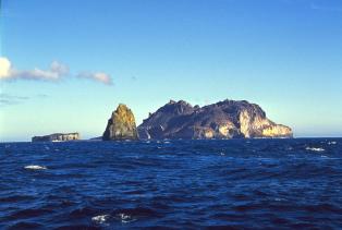
Kerguelen Island
Much of our world is in hiding. It lies below the surface of the oceans and is largely invisible to us, a Maria Incognito. It is a hostile world: we are creatures of the solid ground, who long left the seas behind and cannot return. But more of this forbidden world is being uncovered, by sonar and the occasional human submarine visitor. Gravity maps have revealed the ocean floor in places where ship-based surveys have been sparse. These gravity maps use the height of the ocean surface to determine how much mass there is below. Obviously this does not work on land, and therefore these maps show empty space where the land is, a true Terra Incognito. In contrast, the oceans come to life, showing mountains, plains and chains of (ex-)volcanoes – all of it deep under water, a true Titanic world. (In Greek mythology, the Titans were the children of Earth and Sky – Gaia and Uranus – who, like their namesake the Titanic, became banished to the abyss.) Spreading ridges and transform faults are visible. Many parts of this new world remain next to impossible to explore directly, too deep for all but a few very carefully designed submarines – as we were disastrously reminded by the demise of the Titan submarine. But other parts of this world are adjacent to known islands and clearly are submerged extensions to those, larger structures of which the visible island is just the very top: a submerged part of our world of which we were unaware.
When exploring those maps, one such large underwater plateau shows up in the far southern Indian Ocean. It carries an island on top that looks like an inverted version of Iceland. A quick search shows that the island is already discovered (by Kerguelen – twice), named (by Cook – twice), owned (once, by France), and occupied (by a colony of itinerant scientists). The main island is surrounded by an archipelago of perhaps 300 much smaller islands. I am not sure whether anyone has actually counted them! The archipelago is called the Kerguelen Islands (Cook’s second name was Desolation Island, a name still adopted in French). Kerguelen is supposed to be the most isolated piece of occupied real estate in the world. There is no airport; it can be reached only by a week-long boat journey across a storm-swept ocean. Questions arise – why is it there? Why the underwater plateau? And why does it look like an Iceland of the South?

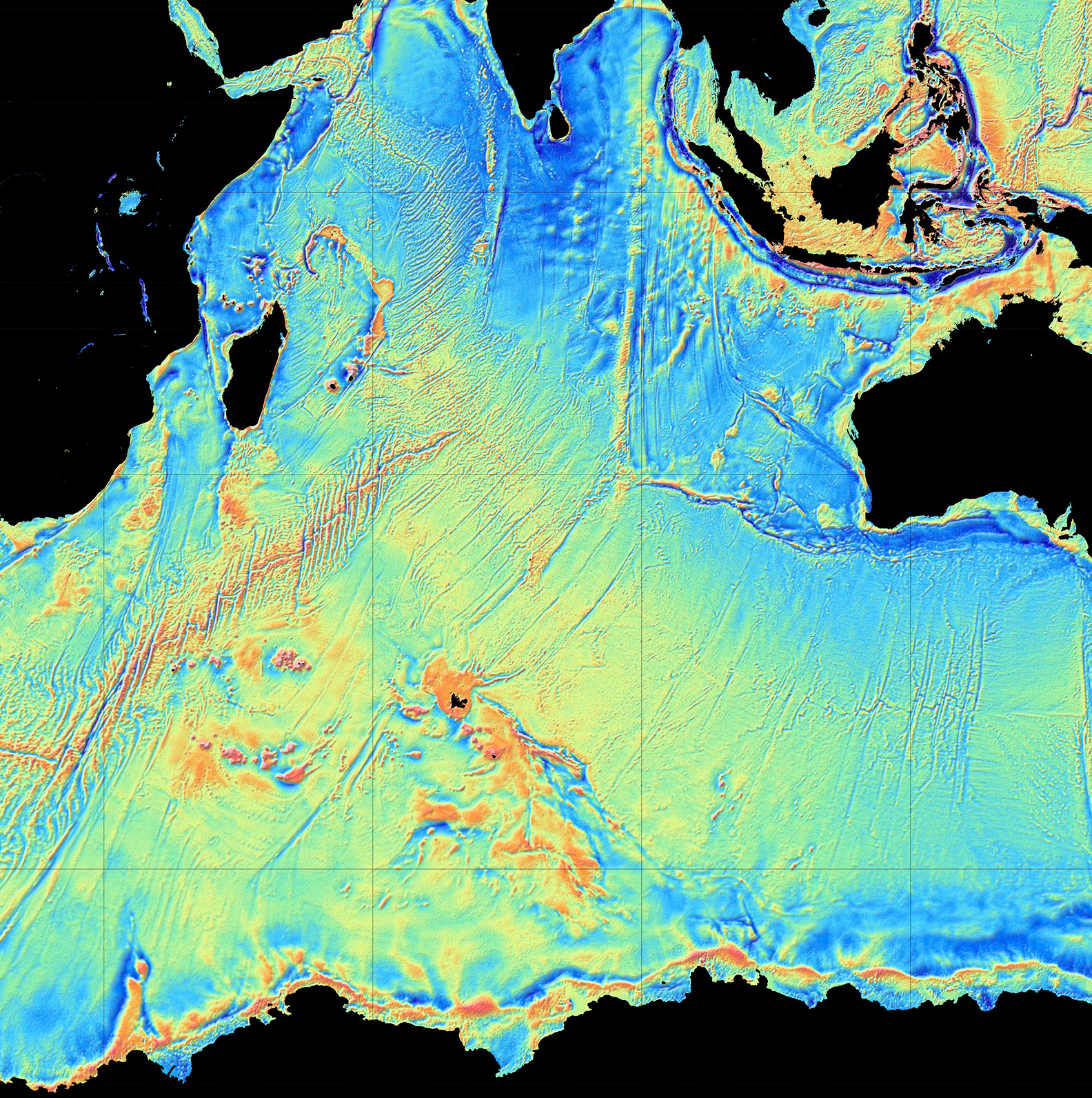
A direct comparison shows that Kerguelen island is rather smaller than Iceland. Adding the surrounding submerged plateau makes it more comparable but still smaller. However, there is much more to the underworld area. Kerguelen forms one end of a much longer, but almost entirely submarine, volcanic plateau, stretching southeastward. The full underwater plateau is shown below (image credit: Australian government). It is over 2000 km long, covers an area of about 1.3 million square kilometres (four times the size of the British Isles, one sixth of Australia) — and it was created by volcanic eruptions. This is a super-Iceland! It consists of three parts, the northern plateau with Kerguelen itself, a central plateau with two small islands (Heard island and McDonald island) and a southern plateau which is fully submerged. Elan Bank, to the side, may also be part of the large plateau. Further south, a trough separates it from Antarctica.
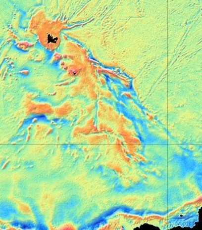 All together, the volcanic plateau is the largest one in the Indian Ocean, and larger even than the Deccan traps! The size qualifies it as a large igneous province (LIP): by definition, this is an eruption covering an area more than 100,000 square kilometres. Eruptions this size are often attributed to hot plumes melting the lithosphere below the eruption site. The head of such a plume can extend over 1000 km. The ‘Kerguelen mantle plume’ is a plume of legend. Kerguelen island is a harbinger of past doom. For all its remote inconspicuousness, this frozen island with its submarine plateau once changed the world. Australia is still living with the consequences.
Source: Irina Borissova et al. 2003, Geological framework of the Kerguelen Plateau and adjacent ocean basins, https://www.researchgate.net/publication/313158291_Geological_framework_of_the_Kerguelen_Plateau_and_adjacent_ocean_basins
Kerguelen Island and the surrounding northern plateau are volcanically dormant or dead. So is the southern plateau. But the central area still has life in it. Both Heard Island and McDonald Island are active. They are in fact the only active volcanoes owned by Australia (a gift from the UK).
The islands
Heard island is 2800 meters tall (it has grown a bit since wikipedia) making it the tallest Australian mountain outside of Antarctica. You would be lucky to see it though: cloud cover can seem near perpetual. On a rare good day, the mountain shows a shape which is a bit like El Teide, with a pyramid cone sitting on a much larger summit. Rather more common is that it is covered in cloud. The island is called Heard Island, the volcano is strangely named ‘Big Ben’ (occupying pretty much all of the island), and the erupting cone is Mawson Peak. It is among the most frequently active volcanoes in the world, probably erupting a lava flow every few months. The most recent one was 25 May 2023, noticed by no one but captured by the Sentinel satellite.
The island experienced devastating seal hunting in the 19th century. As one document describes: “The plain (Atlas Cove) was strewn with bones of the Sea Elephant and Sea Leopard, those of the former being most abundant. There were remains of thousands of skeletons, and I gathered a good many tusks of old-males. The bones lay in curved lines, looking like tide lines, on either side of the plain above the beaches, marking the rookeries of old times and tracks of slaughter of the sealers.” That was the past. Nowadays Heard Island seems little touched by humanity, being uninhabitable and inaccessible. Even the ubiquitous rats are absent, leaving the sea birds to nest in peace (apart from the regular volcanic eruptions, or course). There are also no introduced plants. Apparently an attempt was made to introduce sheep during the Australian National Antarctic Research Expedition from 1947 to 1954 (Australians don’t feel at home without them, apparently) but they did not survive. Sledging dogs were also brought in and did well but served no useful purpose so they were taken to Antarctica. This leaves a recovering but authentic subantarctic ecosystem. The eastern spit is apparently very popular with elephant seals. Leopard seals are still found here in winter (beware) and the 2 million macaroni penguins are as smelly as you can imagine.
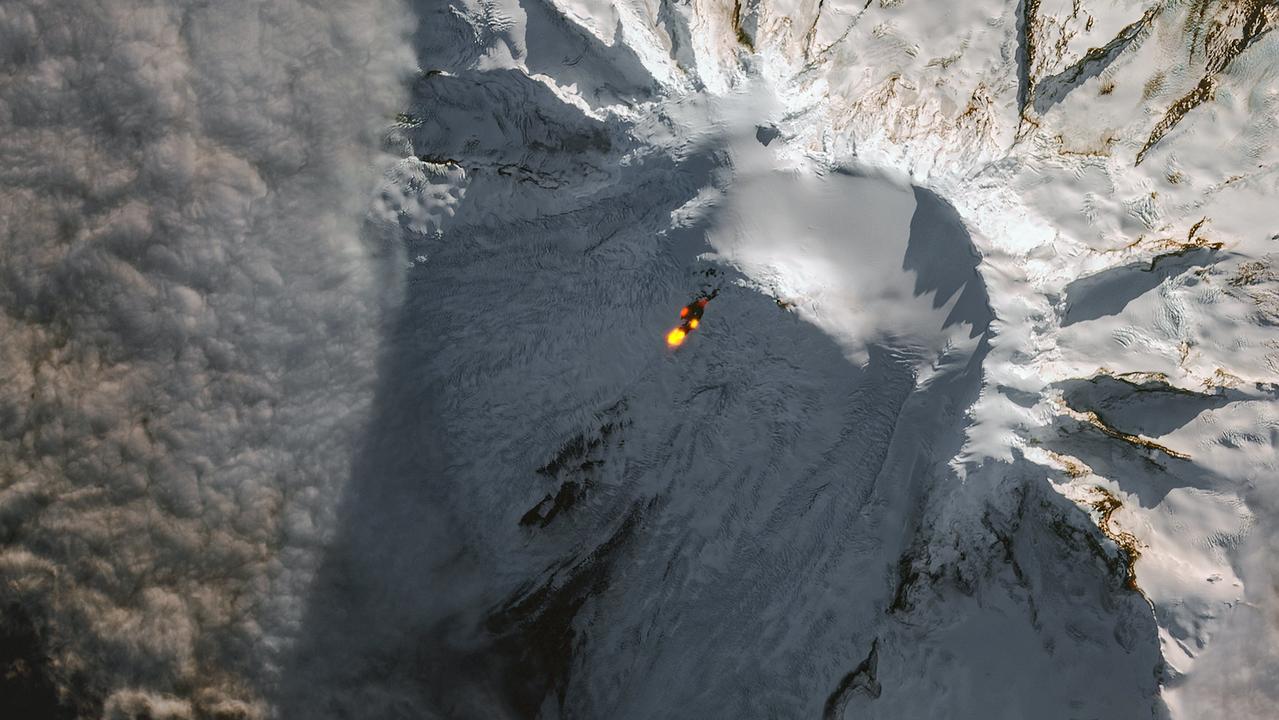
Sentinel image of an eruption at Mawson Peak, Big Ben on Heard Island, on 25 May 2023
McDonald Island with Myers Rock and Flat Island on the left (https://www.farvoyager.com/siov/mcdonald.html)
nearby Flat island ( a descriptive name if ever there was one) has become incorporated in it.

Kerguelen Island. Source: https://earthobservatory.nasa.gov/images/89328/kerguelen-islands
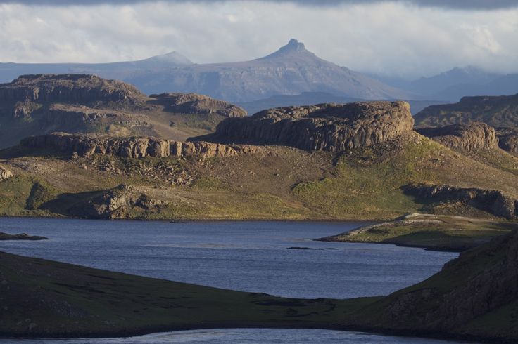
Kerguelen Island is very different from these two volcanic islands. It is much larger, at 150 km across. A description of the island can be found here. The picture at the top of this post shows a scene from the island. The coast is deeply indented with bays; the land is mountainous, rising to almost 2 km. The island shows multiple horizontal layers of basaltic lava, forming a plateau which covers much of the interior of the island. It is deeply eroded and covered by a tundra vegetation. A bonus to people is the presence of edible plants, in particular a local cabbage which provides vitamin-C. The climate is like Iceland’s north coast. Around 4000 reindeer are present, showing the influence of people. So do the wild cats and rabbits! In spite of its isolation, this land is a certified part of the human ecosphere. The reindeer were originally brought to a nearby island by Norwegian whalers (Norwegians don’t feel at home without them, apparently), but they (the reindeer, not the Norwegians) swam their way to Kerguelen freedom. They are the only remaining southern-hemisphere reindeer, after the population at South Georgia was removed. The rabbits came from South Africa in the 19th century and were meant to provide food to the whalers. They are now a major problem especially in the eastern part of Kerguelen. Sheep were a 20th century addition. The survival of feral cats in this tundra world came as a surprise. They descended from cats kept on ships who managed to get to land (probably with human help as they are not noted for swimming). The cats managed to live on rabbits and sea birds.
After the whalers and the sealers had left, an itineracy of scientists came. There are now some 100 people here, living mainly in one town and each staying for a limited time. Tourism is next to non-existent.

Basaltic layers. Source: https://www.tripadvisor.co.uk/Tourism-g1207797-Iles_Kerguelen-Vacations.html
In addition to the central basaltic plateau, close to the coast are several younger volcanic complexes. In the southwest is a series of ring dykes, emplaced underground but visible now because of erosion. They are as young as 5 million years. In the same region are remnants of explosive volcanism: a large caldera and pyroclastic deposits. These may be only 1 million years old and include the last major explosion on Kerguelen. Ross volcano in the south similarly is 1-2 million years old. All these volcanic complexes are extinct. But the inaccessible southwestern peninsula still shows active fumaroles as well as hot water basins reaching 80C. It would be a popular place to visit, had it not been so unapproachable that helicopters are needed for a visit. The suggestion has been made that a hydrothermal system is located underneath the icecap. The heat cannot easily escape from there, and so instead the hot water below the ice feeds the activity beyond the edges of the glacier.
The hydrothermal activity may provide a clue as to why Kerguelen Island is an island. Why is it the only part of the submerged plateau where a large block has been pushed up to above sea level? Other than this, the only islands here are active volcanoes, build up by young lava. To get the old crust to rise up requires a buoyant force below. There must be a heat source below the crust which has lowered the density and thus pushed up the land. The fact that the rest of the plateau is submerged suggests there is less or no heat elsewhere: the warmth is located only underneath Kerguelen Island and nowhere else. But it is currently too weak to produce eruptible magma. The explosive activity a million years ago may have been the last straw of a cooling magma.
At one time, coal mining was attempted at Kerguelen. The very attempt shows there is much more to Kerguelen than volcanics. Coal takes a long time to form: for Kerguelen to have coal, it must be old, far older than a volcanic island should be. This is no Hawai’i, not even a Hawai’i in decline: it has a much more ancient history. (Update: The fossil wood is found sandwiched below the upper basaltic layer and the basement, and was noted already in the early 1800’s during a visit to the northern shores of Kerguelen Island. See below for a description from Geology Today, 2012, Falcon-Lang)

That long history is true for the rest of the underwater plateau as well. Drilling has discovered fossil wood and charcoal in the central and southern plateaus. It shows that at times, part of the plateau, now 2 km deep, was above water and was covered in forests. At that time the plateau was an island the size of Great Britain.
Clearly this is no ordinary ocean floor! Indeed, the Kerguelen plateau is considered a micro-continent, but one that has fallen on hard times and is keeping its head above water only with great difficulty and some help from below. But you can never stop being a continent, even when submerged by 2 km. Continents are the world’s great gift: they are forever.

Reindeer of the south. Source: http://ultima0thule.blogspot.com/2013/03/kerguelen-remote-but-magnificent-sub.html
If this is a micro-continent, where did it come from? They are normally offspring of a bigger continent. We can see the process in Africa: a rift forms, which splits a continent in two quite unequal parts. The African Rift is currently working on dislodging Somalia and sending it into the Indian Ocean. That would create a microcontinent. The Seychelles are a microcontinent which split from India. Micro-continents are geological cast-offs caused by off-centre rifting. But Kerguelen is surrounded by four different continents: Africa, Antarctica, Asia and Australia, in their battle for alphabetical supremacy. So which one is the parent?
And is all of Kerguelen a micro-continent? We have previously seen that the Seychelles are a combination of a micro-continent and a volcanic addition: part has continental crust underneath, but another part is build on oceanic crust. It turns out, this is true for Kerguelen as well. It was not easy to determine. The whole area is covered in kilometers of basalt which gives little clue to what lies beneath. Seismic studies have shown that in the crust underlying the southern plateau, earthquake waves travel at seismic velocities which are typical for continental crust. But in the north, underneath Kerguelen itself, that layer is not seen and here the crust appears to be oceanic. It therefore appears that the microcontinent is the southern part and that the north is a later addition without any continental affinity. The main area that sticks out from the sea is therefore oceanic, and the deepest submerged parts are continental!

Source: http://www-odp.tamu.edu/publications/183_IR/chap_01/c1_1.htm
The continental part of Kerguelen had volcanism in two phases: between 110 and 120 million years ago in the southern part and between 90 and 100 million years ago in the central part. The oceanic extension in the north is much younger. Kerguelen island itself is 25-30 million years old, with a minor volcanic resurgence 10 million years ago which over time migrated south to Heard Island. The gaps in time are so large that the various phases of volcanism probably have different origins. This does not look like a very long-lived hot spot which miraculously stayed underneath Kerguelen, moving with the ocean floor the whole time. Were there several mantle plumes impacting Kerguelen at different times? Or was it something else?
The answers to these are found elsewhere. We need to look around the Indian Ocean.
The Indian Ocean
The map below shows the location of Kerguelen in the Indian Ocean (click to see full detail). It is not the only feature in the ocean. Spreading ridges separate the main plates. Faintly visible is the SouthEast Indian Ridge, the ocean spreading centre between Kerguelen and Australia (the transform faults are better visible than the spreading ridge). Much clearer is the spreading ridge towards Africa. A straight line extending almost to Myanmar is called the Ninety East Ridge and looks very much like a hotspot trail. It points directly at central Kerguelen. To the right of its southern end is the Broken Ridge. Broken Ridge is a missing sliver of the central Kerguelen Plateau, separated from it by virtue of becoming stuck on the wrong plate. A spreading ridge is located midway between the two – microcontinents can apparently split and produce nanocontinents. To quote Jonathan Swift,
Naturalists observe, a flea
Has smaller fleas that on him prey,
And these have smaller yet to bite ’em,
And so proceed, ad infinitum
And so supercontinents form continents which shed microcontinents and those split off nano-continents. The smallest, too small to survive, perhaps become the in-continents.

Source: wikivoyage
The ages confirm that this all this oceanic debris is linked. The Broken Ridge is dated to 95 million years ago, whilst the Ninety East Ridge ranges from 83 million years at its northern end to 37 million years in the south. Further afield, fossil dykes and lava flows in India, at the Bay of Bengal, are 115 million years old. So are fossil dykes in Antarctica, on the far side of Kerguelen.

Higher resolution map of our youngest ocean. Click on the map for full resolution. (Source: National Geographic).
Origins
Let’s first match up the younger volcanics. The tip of the Ninety East Ridge nearest to Kerguelen Island has the same age as the Island. The spreading ridge is midway between them. Clearly, Kerguelen Island belongs to Ninety East Ridge. It is the youngest part of this ridge, and came from a lava flood which occured on or near the spreading ridge. Kerguelen Island really did form like Iceland. The rest of Ninety East Ridge formed earlier, over the 50 million period before this event. It came from the same hot spot and was carried away by the moving Indian ocean plate. The Ninety East Ridge is one-sided, showing that the hot spot was not on the spreading ridge for that time, but was located on the Indian Ocean plate. It ended up on the spreading centre only during the final lava flood when it also jumped to the other plate. The spreading centre that had been further south shifted northward, to the hot spot, and separated it from its tail.
The hot spot did not end its existence with the formation of Kerguelen Island. It had lost much of its vigour, but it remained on the spreading ridge. There are two other volcanic islands at its current position. These are the islands of Amsterdam and St Paul, with a series of nearby submarine volcanoes which are strangely named Chains of the Dead Poets. (Indeed, they carry the names of dead poets.) These two islands are at the very centre of the Indian Ocean, at the central point between Antarctica, Australia and Madagascar. It is a telling location.
We need to go back further in time to even deader poets. The older Kerguelen volcanics comes in two groups, at 95 and at 115 million years old. The group at around 95 million years old shows up only in central Kerguelen and in Broken Ridge. These were clearly a single entity at the time. The separation from the spreading ridge is similar to or just a tad more than that of the Ninety East Ridge. This shows that the separation occurred at about the time of the younger volcanics (37 million years ago) or perhaps a few million years before, a long time after the eruptions here had ended. This was the time the spreading ridge jumped northward, and it cut right along the edge of the (probably already submerged) central Kerguelen plateau. A small bit of the plateau found itself on the wrong side, started to be carried away and became the Broken Ridge – an appropriate name.
The spreading centre itself was much older. Nowadays it is located between Australia and Antarctica. The spreading began in earnest 85 million years ago, as indicated by the oldest ages seen at the furthest side of the Ninety East Ridge. What had happened between 85 and 37 million years ago? The long line of the Ninety East Ridge shows that the ocean floor was moving north. This was the same time that India was crossing the ocean and eventually slammed into Asia; the ocean floor around Ninety East Ridge was moving with India. From the length of the Ninety East Ridge and its age spread, the speed of the plate was around 10 cm/yr. The formation of the Ninety East Ridge continued for all this time, until it culminated 37 million years ago with the formation of the northern Kerguelen plateau. This was the time when India had collided with Asia, eradicating the subduction zone between them. This stopped the pull on the oceanic plate, and the spreading ridge slowed down markedly. Perhaps this is why the northern plateau grew so large: for a while, the plate remained near stationary above the magma producing area.
Is the hot spot that formed the central Kerguelen plateau 95 million years ago the same one that formed the Ninety East Ridge? It seems so. The plateau is attached to Antarctica and this continent is very reluctant to move. The plateau has perhaps drifted a bit south-southeast but did not go far. The spreading centre was located such that during much of this time the Kerguelen central plateau was on one side (Antarctica) but the nearby hot spot trail was on the other side.
Interestingly, there were other changes happening 85 million years ago. This is the time when Australia began to separate from Antarctica. Did this separation start with the arrival on the surface of the hot spot that formed the central Kerguelen plateau? Or are we too far from Australia for this?
We need to make another step back in time. The earlier burst of volcanic eruptions occurred 115 million years ago. This formed the southern Kerguelen plateau. The same event is also seen in dykes in nearby Antarctica which formed at the same time. The Rajmahal traps in north east India and Bangladesh also formed at the same time. All these areas were closely connected 115 million years ago. India, of course, at this time was part of eastern Gondwana, sitting between Africa and Antarctica. The current long-distance relations came from the rifting of this part of Gondwana.
But this was still not the beginning. 150 million years ago, this was the heart of eastern Gondwana, when Australia, Antarctica and India were all connected and Africa was beginning to separate. To the north of eastern Gondwana was the Tethys ocean; beyond that, Asia was beginning to take shape. Of course India, Bangladesh and the Himalayan countries weren’t there yet. They were still part of Gondwana, migrants still waiting for the chance to make the crossing.

They waited 15 million more years, while the Jurassic gave away to the Cretaceous and far away the Atlantic Ocean began to form. A minor extinction event, called the Tithonian extinction, heralded the incoming Cretaceous. It is named after a prince of Troy, another lost world. The cause of this extinction is not known. But the world was being redrawn and a new age dawned. 135 million years ago, a flood basalt burst out in what is now southwestern Australia. The remnants are seen in Bunbury, but also very far away in southeastern Tibet. Obviously, these two places were in the same location at the time, in the heart of eastern Gondwana and far from any ocean. India was larger than it is now: some of its area would later be lost in the collision with Asia. The Bunbury basalt erupted where southwest Australia joined with northern Greater India. It was the beginning of the end: eastern Gondwana was beginning to break up in its very heartland.

Source: Rajesh K. Srivastava, 2019
The eruption subsided but it was too late for the continent: Gondwana had broken. But 20 million years lava flows restarted in what is now the southern Kerguelen platform, at the time south or west (500 or 1000 km away?) of Bunbury. And 20 million years after that, the eruption deja vu’d again in what is now the central Kerguelen platform. All three events are often considered part of the Kerguelen flood basalt, but they can also be seen as three separate, unconnected eruptions. A comparison in our own world is provided by the African rift, which started with a flood basalt 30 million years ago and has migrated over that time thousands of kilometers southward. There is now a hot region below eastern Africa, but is this the same hot spot of 30 million years ago? And is elevated Zimbabwe the same hot spot or a different one? Do hot spots perhaps come in families and generations?
The three Gondwana eruptions first caused a rift between Australia and Greater India, and later between India and Antarctica and between Australia and Antarctica. It started with a triple point where the three different branches cut the links between three continents. A slight jump of the rifts separated the southern and central Kerguelen platform from their continents. The question which continent they came from is difficult to answer as the three were one. Based on age and location, one can argue that Kerguelen is a lost piece of Antarctica, but India could also put in a reasonable claim. The Broken Ridge still forms a line that points towards Bunbury, showing that although Kerguelen/Broken Ridge were not part of current Australia, they were on the rift that extended from it.
After the end, the hot spot remained active but it was now under a fast moving plate which caused it to form a long, straight trail of volcanoes: the Ninety East Ridge. India was moving north, crossing the Tethys ocean and carrying parts of the first two flood basalts with it. One ended up near Lhasa and one near Bangladesh – their separation shows those two events occurred at least 500 km apart – possibly much more because of the compression of India. Over 20 million years, that amounts to only a few centimeters per year, so it may be that it was not the volcanics that was moving, but the newly created plates.
Finally, 37 million years ago, when India had collided with Asia, the Kerguelen region again erupted in flames. Was this a new flood or was it just because the plate had stopped moving? At the same time, Australia accelerated in its northward motion – there was a re-organisation off the subduction zones in the Indian and Pacific Oceans (still connected at the time). The fire created a new extension to Kerguelen, but this time build on oceanic crust. After that, Kerguelen found itself moving away from the speading ridge and the volcanics subsided. Did the collision of India affect the magma supply here, far in the Indian Ocean? Perhaps the hot spot had long gone, and the volcanics came from a crustal weakness together with the spreading, allowing mantle material to reach for the surface. Or perhaps there still is residual heat here dating back to Gondwana. Either way, some volcanics continued at the spreading ridge.
There was one more chapter to the story: why did Kerguelen island remain above, or re-emerge from, the sea? Once it left the hot spot behind, it would have sunk below the waves. There was another volcanic episode 10 million years ago, at a time when it was already far from the spreading ridge. Weak activity continued afterwards. It is not clear where that re-activation came from – a sideways convection current from the spreading ridge, perhaps, stopped by the thick crust of the Kerguelen plateau? Or was it related to the beginning of the collision between Australia and Southeast Asia, east of the Wallace line? That seems more likely: the subduction pattern again changed, the pull on the Indian Ocean changed and this reactivated the weakness still present near the edge of the Kerguelen plateau. The map shows a trough. Stress does not like edges.
And that is the story of Kerguelen. It holds memories of a very different world when the southern hemisphere was united. Eastern Gondwana broke down because of massive eruptions which happened over tens of millions of years. The rifting gave us the Indian ocean – but it also left us debris all over the ocean. Kerguelen has drifted away from the original centre of the action – that is now at Amsterdam/St Paul. A little volcanic activity is still continuing but it is no longer attached to the hot spot to which it gave its name. The world has moved on. But we should look at Kerguelen, and remember. It is an elegy written in lava. Gondwana, in memoriam.
Albert, August 2023

‘So you are from Gondwana too?’
Reading:
http://ultima0thule.blogspot.com/2013/03/kerguelen-remote-but-magnificent-sub.html
Paul J. Wallace et al: Origin and Evolution of the Kerguelen Plateau, Broken Ridge and Kerguelen Archipelago: Editorial, Journal of Petrology, Volume 43, Issue 7, July 2002, Pages 1105–1108
Regis Ballestracci, Jacques Nougier:
Detection by infrared thermography and modelling of an icecapped geothermal system in Kerguelen archipelago, Journal of Volcanology and Geothermal Research, Volume 20, Issues 1–2, 1984, Pages 85-99
1. Leg 183 Summary: Kerguelen Plateau-Broken Ridge—A Large Igneous Province: http://www-odp.tamu.edu/publications/183_IR/chap_01/c1_1.htm
Sheng-Sheng Chen and others: The Tethyan Himalaya Igneous Province: Early Melting Products of the Kerguelen Mantle Plume, Journal of Petrology, Volume 62, Issue 11, November 2021
Francine Bénard, Jean-Paul Callot, Roland Vially, Julien Schmitz, Walter Roest, Martin Patriat, Benoît Loubrieu:
The Kerguelen plateau: Records from a long-living/composite microcontinent,
Marine and Petroleum Geology, Volume 27, 2010, Pages 633-649
Rajesh K. Srivastava: Early Cretaceous alkaline/ultra-alkaline silicate and carbonatite magmatism in the Indian Shield – a review: implications for a possible remnant of the Greater Kerguelen Large Igneous Province, Episodes, Volume 43 (2020), Pages 300-311 (https://doi.org/10.18814/epiiugs/2020/020017)


Another ‘paleo-tectonics’ post written by Albert? Class is in session, this just made my weekend!
Can’t wait to dive into this today.
Have just seen the title, maximal praise before reading, great subject, great time, chapeau! Really looking forward to reading it.
Interesting deep dive into continental history, reading this inside a tent in Landmannalaugar, Iceland.
Fascinating a very nice article indeed! its also very Impressive how cold the sourthen ocean is for its latitude. Kerguelen sit at latitude 49 thats well south above most of Siberia and London, yet beacuse its a small landmass in a cold ocean its as cold as greenland almost, while siberia at same latitude can reach + 50 c in summer, while Kerguelen may never go above 10 c for most of the year.
Heard island is even more bone chilling, its at latitude 53 yet having almost a true polar climate! shows how strong Antarticas cooling effect really is, its as far from the pole as Hamburg is yet near freezing all year around, I guess in Antartica the Ice Age glacial never really ended and been so since Miocene.
Heard Island must be one of the worst climates on the planet, always cold and wet insanely windy and near freezing and super high humidity, its a marine cold that goes all way into the bone.. only raw tough fishermen and grumpy sea captains does not complaint in souch conditions.
Looks like Volcanism in Kerguelen is on decline and probaly will die out in a few millions of years I guess
Bouvet Island may be worse! https://www.volcanocafe.org/the-island-at-the-end-of-the-world-bouvetoya/
Bouvet has it’s good days, last time I was there it was a brilliantly sunny day, with visibility about 50 miles, gentle breeze and mild temps. We did a complete circum navigation of the Island, and I was able to photograph the entire coastline from about 2 miles with a 300mm zoom. The fumeroles marked onthechart and in the sailindirections are no longer visible so it seems things are cooling down. This was in 1997, when I was the Ice Pilot on a South African Navy Ice Breaker.
So its even more cold and wet and miserable then?
Still spectacular scenery! example when heard Island rise up in an overcast cloud layer .. grey all around and ocean is in darkness yet sun shines through a cloud gap on the glaciers, and the sea teems with millions of seabirds and waves the size of manhattan buildings .. souch Epic sights must have awed early sailors there
Great, Albert !
Fascinating article of a fascinating place, Albert.
There is a nice linear chain of volcanoes that runs from the central complex of Kerguelen Island to the active Heard volcano. Looks like a “hotspot”, and maybe the continuation of the Ninetyeast Ridge, although there IS a 10 million year old gap between the demise of the Ninetyeast Ridge (40 Ma) and rebirth of Kerguelen (29 Ma). It’s funny how it’s retracing its own steps. Kerguelen Island must have been an impressive sight when it was active 29-24 million years ago, lava layers over much of the island gently dip away from Cook Glacier, the high gravity point, with increasingly older lavas exposed towards Cook Glacier. It must have been an enormous shield volcano, taller than today and somewhere around 200 km in diameter sub-aerially.
https://doi.org/10.1016/S0012-821X(99)00271-X
Also worth noting, the Ninetyeast Ridge, it erupted at a rate of 0.18 km3/year, according to the linked article, and it lasted for 40 Ma of continuous activity. Hawaii has done about 0.1 km3/year for the last 3 Ma, and before than it was mostly weaker except for a few punctual episodes like Puhahonu, or maybe Nintoku. So the Nineteyeast Ridge was probably more powerful than Hawaii, and probably Iceland too, in terms of productivity.
Super Earths must be crawling with these features with their higher internal heat budgets and more powerful mantle convection, Icelands, Hawaiis, Kerguelens everywhere and small twisted continents and hyperactive tectonics
Even 2 Earth masses will add some insane internal heating
The northern plateau was build around 35-30 million years ago, from dates at the bottom of the pile. The younger dates are the upper level, so the later volcanics that build on it. I think it is hard to show that there was rebirth at 29 million years, rather than a continuation of the volcanics that build the basement. I would guess it tapered off instead, and that there was no earlier gap in the eruptions – it is just that earlier flows are buried far below the surface. There was a long gap after 24 million years ago until around 10 million years.
The chain of submarine volcanoes suggests that the activity remained on the spreading ridge during this time.-Wrong statement: the chain goes south and is activity moving south after 10 million years ago. There is no chain between Kerguelen and Amsterdam Island, although there are small submarine cones.There is this one article that dates one of the seamounts between Heard and Kerguelen:
https://agupubs.onlinelibrary.wiley.com/doi/pdfdirect/10.1029/2001GC000251
The dated volcano is the large seamount southeast of Kerguelen Archipelago, that formerly must have been an emerged shield volcano (before erosion). The plateau Ar-Ar ages, which should be the most reliable, all cluster around 21 Ma. So Kerguelen Archipelago 29-24 Ma, the seamount to the southeast 21 Ma, and three more volcanoes to the southeast lies the active Heard, looks like an age progression. -Changed southwest to southeast, I had confused the direction before. I refer to the chain of volcanoes within the yellow polygon in the gravity map above, 5 volcanoes/volcanic complexes lying on the same line from Kerguelen to Heard.-
As far as I know the oldest dated Kerguelen Archipelago lavas are 29 Ma in age, but of course there could be older lavas below:
https://doi.org/10.1016/S0012-821X(99)00271-X
I see that one article mentions 35 Ma old lavas in the Northern Kerguelen Plateau, so maybe volcanism was really continuous all throughout. But I would feel more comfortable with quoted Ar-Ar plateau ages and the location from where they were taken.
There are some references to it in Coffin et al. 2002 (https://academic.oup.com/petrology/article/43/7/1121/1465694) The paper by Duncan (https://academic.oup.com/petrology/article/43/7/1109/1465690) gives the basement dates based on the deep sea drilling program. Those are the dates I used for the post.
The date of 21 million year for the submarine volcano that you mention surprises me. I had expected it to be younger and associated with Heard Island. But I like surprises
These Islands makes me have almost comical nightmares of being crushed to death by angry male Elephant Seals.. mean and agressive things with males growing up to many tons
😂
my friend Spike Page describes them as the ultimate of savagness and dread and inks of violence : D 😉
A mating male battle infront of the steaming heard volcano woud be quite a sight .. ground shakes
Really good and interesting article, thanks Albert!
Couple of comments. First I was idly looking at the island in Google Maps: there’s a very pretty lava flow on the SW coast (here) that looks a lot like the lava flow at Tatio ( ?resize=700%2C518&ssl=1″ rel=”nofollow ugc”>this one, from Héctor’s ten supervolcanos article which he linked in the comments on the CCN article).
I mention it because despite the appalling weather the SW Kerguelen lava flow is quite fresh looking. If the Tatio one is only 100ka then this one looks even more recent than that. Maybe we just missed Kerguelen’s last throw of the dice by only quite a short time, at least geologically speaking.
Second comment is the flood basalts and extinction event at 135Ma. The Deccan Traps and the Siberian Traps are coincident with asteroid strikes, possibly on the opposite side of the globe – a spallation effect maybe. Both are coincident with mass extinction events also.
So the fun idea is an asteroid strike on the other side of the Earth in 135Ma BPE caused both the formation of Kerguelen and the great split up of Australia, India and Antarctica. And the Indian Ocean. That would’ve been a fine Earth shattering kaboom, and Kerguelen might actually a byproduct of an interplanetary event.
I’m just surmising. I defer to volcanology colleagues for such things since I’m only a chemist.
The current active volcanoes have slower magma supply under a thickened crust, so that heard Island do evolved stuff is not strange
Bruce is talking about the viscous flows at the southwest end of Kerguelen island, not Heard is ald which has erupted evolved magma before but is mostly basaltic.
Heard today is a very hot volcano, probbaly one of the most active on the planet, as far as I know it has been erupting every time it has been visited and every time it has been observed from satellite, so continuously active for decades now if not centuries, and Mawson Peak overflows every few years. There is even has a lava lake, as in a fluid convecting hawaiian type lava lake. It might be a stratovolcano but it is built of highly fluid melt, it is a lot like Villarrica or Shishaldin, or how Nyiragongo probably was before it formed its caldera, basically a polygenetic lava geyser although perhaps those days are in the past or on pause.
Evidently the hotspot is highly active even if it has declined from its days in the Oligocene as a Mauna Loa x2 🙂
Seems plausible the answer for Kerguelen as to why it is still afloat so to speak is that it is *not* extinct. Some relatively fresh-looking features and besides that we have a bit of a tendency to look at a system and be like “it hasn’t done anything in X years so it must be dead” when X years is tiny relative to that system’s history and so not necessarily a strong reason to think it is dead as opposed to napping.
I guess the fact the recent eruptions on Kergualen itself are trachyte eruptions probably means volcanism there is waning, but for the past 20 million years the head of the plume does seem to be quite constant, not as active as before that but not obviously dying out.
I did a bit more research and actually Heard has been visited not erupting but that was in the late 90s, since 2003 it has been continuous, and with such a smooth cone in a glaciated environment Mawson Peak must be very young and probably never more than a few years asleep since it formed. Lava is basantite composition and so similar to Nyamuragira and La Palma, and should be extremely fluid, and probably generayed quite deep in the mantle spurce, deeper than in Hawaii.
The plume or hot spot is now feeding Amsterdam/St Paul so it kind of has an alibi – it isn’t here. If you look at how Kerguelen was build, the Northern plateau mainly formed 35-30 million years ago (perhaps starting as early as 40 million years) and the top dressing that is now the main part of the island came 30-24 million years ago, so clearly a continuation. Then silence for 15 million years (likely there were minor eruptions but they have left us no trace). The new volcanism build volcanoes around the rim of the island which are still nicely visible along the shoreline. (The icecap may be hiding more things elsewhere though.) The main events were done by 5 million years ago, but along the southern edge there was volcano initiation until 1 million years ago. After this eruptions faded although not disappeared entirely. There are still hydrothermal vents along the southwest and of course further south there are proper volcanoes as you mention. I think this episode was due to the changing stress field in the Indian Ocean as Australia impacted the Pacific plate. This opened up old weaknesses such as left by some past spreading or transform faults, and allowed magma and heat to well up. It is not the old plume – that would manifest itself rather differently. This is a bit of weak intraplate action.
Mount Heard has an interesting history which I had not looked at. The island started out 22 million years ago, i.e. at the very end of the building of Kerguelen Island. It is part of the marine cones Hector mentioned. The lavas are somewhat evolved (there is some basanite but towards andesitic), but come from an ‘incubated’ reservoir of material left over from that phase. Presumably it gets remelted when heat is present.
How did it look at its Peak?
Laki sized eruptions every centruy?
Coud Hawaii be heading there with the increase in output
Well Hawaii is apparently 21 km3 a century as it is, which is theoretically big enough to do a Laki every century, and the biggest fast subaerial eruptions there are still generally 2-3 km3, unless you count the decades long eruptions as single events which could be debatable. Eruptions from Kilauea going offshore might be bigger but definitely not as often as once a century. Grimsvotn itself has a much lesser supply only 1/10 of Hawaii, and VEI 6-7 eruptions from arc volcanoes are less still typically and yet the eruptions are huge, so seems the supply is not the important part of the equation necessarily.
So I imagine Kergualen at its peak was doing similar sized eruptions, maybe a few km3 drainouts every few decades and probably more or less constantly overflowing at high rate, sending pahoehoe flows up to 100 km away to build up its shield, it maybe wasnt as tall as Hawaii. But drainouts of over 10 km3 would have probably been somewhat rare, maybe once in a century at most, high supply doesnt necessarily make this style of eruption more likely. But this is entirely speculation, it really might have been exactly as you hypothesize too 🙂
Oops, I didn’t mean for Héctor’s sat pic to insert itself. But if you look at the Google Maps link I gave, which is just above the Tatio pic, you’ll see what I mean.
Flood Basalts have with mantle heat stuff to do rather than an asteorid strike whos heat energy is very local and Earths rock is a very poor conductur as well
The co – happening of flood basalts exterminations and asteorid holocausts can be flushed down in the toilet
Still the seismsity from a strike can probaly set off pressurized magma chambers, but it wont create a LIP in the first place on the other side of the world … still both of them are potentialy insanely bad phenomena defentivly
It’s the seismic waves. On impact you’ll have P and S waves radiating from the impact site, carried by the crust. When they arrive at the other side of the Earth they are naturally concentrated again – so massive crustal deformation seems likely at that specific point.
As I said both the Deccan Traps and the Siberian Traps are pretty much exactly aligned with known massive asteroid impacts timewise. The former famously took out the dinosaurs (well land ones, I have lots of flying ones who visit my house. :-; ).
How a flood basalt eruption could occur due to such a cataclysmic event I do not know, since the basalt has to come from somewhere. Lots of it. But as I said the timing of the asteroid impacts with flood basalts taking place on the other side of the planet seems a lot more than coincidental.
Sounds like ‘super-fracking’, which would stimulate –Or at least ‘ease’– flood-basalt activity. But, only from where it was *available*, so not exactly ‘opposite’ impact site…
You wont get much volcanism without extra heat in the mantle
So Im a firm beliver of plumes or ”megaintrusions” as Hector calls them in his research
I would think an impact of the required magnitude to set off something like that would be more likely to start volcanism in the crater itself? Many ancient impact craters are marked by gravity anomalies which come from ring dikes emplaced around the edge of the structure, most recently for the newly discovered Deniliquin structure in southeast Australia, which is the biggest potential crater found on Earth so far. And we know from the Sudbury crater and the lunar mare that big impact craters at least sometimes do become volcanically active. I would hypothesize impacts in the deep ocean have a high chance to erase themselves this way, possibly a few of the oceanic plateaux in the Pacific are results although they dont need to form this way. But Deccan Traps level eruptions need more than just fractured crust to get so big otherwise every continental margin would be flooding with lava endlessly.
Consider the american southwest.
Many thousands of meters of uplift suggests to me that beneath lies a huge volume of hot magma. In a sense its a gun waiting for a trigger. An asteroid impact is really a huge input of energy straight to the crust so its perhaps unsurprising that it could trigger events at its antipodes if the energy is already there.
This mechanism rather solves the “is it volcanism or is it asteroid” argument because its both, which makes a lot of sense.
On a totally different track New Scientist reports Covid 19 infection gives some, possibly good, immunity to sars and mers, “unexpectedly”. This supports my comment in 2020 that C19 could be a sars vaccine that escaped from the lab.
I thought the Colorado Plateau and Sierra Nevada was high up because part of the lithosphere detached and fell off. That would have probably generated some significant volcanism but it was long ago and today it is just continental crust that is unusually thin and thus buoyant? There are volcanoes in the area but it isnt anything particularly dramatic.
If an impact hits an already active area or directly antipodal to it that is a bit different than being the cause of it. Decompression melting is a thing but it needs some sort of catalyst. Hawaii is extremely hot, the hottest lavas of the entire Cenozoic and even before that are erupted there, and to some extent this applies to all hotspots obviouspy. So decompressing the mantle there would result in all hell breaking loose, something that possibly is happening a little bit right now with how the data at Kilauea looks.
Subduction introduces a lot of volatiles and especially water that lower the melting point of the mantle and the descending plate probably will stir it up a lot too.
But an impact is a surface level event, if the mantle under it is not fertile to melt then just having a fractured crust like that wont necessarily do anything.
Basically just saying that it doesnt seem a very good case that LIPs are exclusively caused by impacts, but maybe some could have been if conditions were right. Although my bet would be that this would be at the site of impact not antipodal to it but this is only a speculation.
There are no known cases where an impact triggered a LIP. As said, it would require melt to already be available – an impact on its own will not do. For the Deccan traps, they were already half way through when the impact happened, so the two were simultaneous but unrelated. The lunar Maria did become lava-filled but this may have happened a long time after the impacts (billion years or more) and the magma, once formed, just used the weakness of the circular fault to reach the surface. The best case for an impact-induced LIP might be Venus since there is plenty of magma available under the crust (probably) but again we have no known cases – but this may of course just be due to the craters being completely buried! Mars – no known case either. So in my opinion, not impossible but rare.
I also doubt that relation between impacts and LIP. The more I dig into it though I have the impression that LIP were caused by mantle plumes like also the opening of spreading ridges and splitting of continents.
I wonder whether in the end the core and the mantle are the masters, and when a weight and heat imbalance develops over a long time span, like a big single mass in one spot, near the equator or around the south pole, mantle updwelling might develop in several places and solve the problem by splitting the mass up.
Venus is supposed to have this updwelling too, but as there is no water there is no movement, so the problems cannot be solved. So the whole crust is changed, but not the position and the size of continents.
This Wilkes Land Crater in East Antarctica might have been caused by a former mantle plume. When there is no chemical evidence for a meteorite it is rather improbable that the crater is caused by a meteorite. Some evidence should be there. So here we have a suspect for a former mantle plume potentially resonsable for Bunbury and maybe even Paraná (same time) if South America sat close to Australia. On the other side of Antarctica there is a flood basalt. This is like the Dinosaurs. It is a flood basalt that was FOUND. There might be a lot more under the ice.
Exactly as Albert says
But its also true that really large impacts forms melt provinces gigantic seas of impact melt that maybe seen as a ”non volcanic LIP” But souch impacts ends up destroying the biosphere If they happens again : O
These are asteorids a few 100 km wide that do souch stuff, but even smaller ones like chicxulub are capable of cross continent scale firestorms
To form a LIP you needs wastly to increase melting in the astenosphere, and the most easy way to do that is extra heat and it will decompress into large ammounts of magma, many LIP s are specialy crazy in opening of continents with decompression plus extra heat
Thats why hotspot concept seems pretty solid
But Hector is deeply working on alternative theories that will be very intresting to read later
Galapagos is weaker than Hawaii althrough haves huge subarial calderas and some buried Hawaiian ones are just as big
Whats their largest eruptions ( still Galapagos fissure eruptions does not seem worse than Mauna Loa) even last years ”standard” Mauna Loa eruption was immense in vent scales well over 10 km long fissure system 🙂 shows what monster volcano Mauna Loa really is
Still Sierra Negra and Wolf where insane too
Sierra Negra can do Laki sized eruptions, the flow up on the north flank next to Alcedo is probably between 5 and 10 km3, and with a 600+ meter fountain at the vent. The flow is not gigantic in area (still, 150 km3) but it is really thick, at least 20 meters, and maybe way more if there was once ocean in between. This flow is also probably only a few centuries old, almost certainly under 1000, and the only map showing the surface of Sierra negra by age agrees with this
Even historically it has erupted 1 km3 of lava from a fissure at Volcan Chico in 1979. Volcan Chico is the name for the north caldera rim, so this huge eruption was a summit eruption, not a flank eruption. And it lasted only 2 months, and was already mostly done within a few days if the single image I have found of it (from a satellite) is to be believed 🙂
I didnt believe it could be so big but all of the lava on the north flank downhill from the rim is from the same eruption, it all overlaps…
🤯 I see the vent now in Google Earth .. godly stuff the pit is around 1 km long / wide! yes a 800 meters high Hawaiian fountain, the opening curtains probaly been buried by later flows, woud be fun to walk near souch an event and photobomb myself infront of the fountain in an Oppenheimer style film poster
Sierra Negra also have some very very large tuff cones as well so fissure eruptions of incredible power
Galapagos looks like miniatyre versions of marsian shields specialy Arsia Mons
The youngest eruptions on Kerguelen Island are dated to 150,000 years ago and are from Mount Ross, in the south. That is supposed to be the youngest volcano on the island. It began erupting 1 million years ago but was largely finished by 400,000 years ago. Sin ce that time there have been a few flank events only. The Southwest peninsula that you refer to is older but is the site of an active hydrothermal system. It is almost impossible to get to so is little studied. But there is no published evidence of a young lava flow there.
Neat map (1) showing that Kerguelen on the Antarctic Plate sits neatly between two spreading zones and must also follow Antarctica towards the tip of South America where Antarctica, parts of the plate, are being subducted which I wasn’t aware of so far.
Oh, link:
https://www.researchgate.net/figure/Tectonic-map-of-the-Antarctic-plate-showing-bounding-spreading-ridges-and-subduction_fig1_337563992
There was an impact during the Deccan traps (although it actually happened during a quiet interlude in this eruption!) but there is no evidence for one during the Siberian traps. The one you mention has no crater, no date and no debris! That is rather incomplete as evidence. It was purely based on the idea that there should have been one.
You are right Bruce of Newcastle. Apparently you’ve stumbled upon an obscure active volcano known as Pic Saint Allouarn. There is a pair of good articles covering the volcanism in this region:
https://www.academia.edu/download/83892673/The_Neogene_to_recent_Rallier-du-Baty_ne20220411-16117-1swnx55.pdf
https://www.academia.edu/download/71190886/s0377-0273_2802_2900509-720211003-11071-11whkfs.pdf
https://hal.science/hal-03024359/document
These are some quotes from the second article:
“The 1.15-Ma to recent volcanic activity, manifested by the eruptions from the Table-del’Institut, Dôme Carva and Pic Saint-Allouarn (caldera) volcanoes, is tightly coeval with the 1.02-0.13-Ma slightly silica-undersaturated Mont Ross volcano, located 40 km east of the Rallier-du-Baty Peninsula (Weis et al. 1998).
However, the activity on the Rallier-du-Baty Peninsula [the location of the young volcanoes and calderas] has persisted well after the extinction of the Mont Ross volcano.”
Referring to Pic Saint-Allouarn: “Trachyte pyroclastic flows, emerging from below the ice and probably aided by melting of the ice sheet, diverge radially from a centre located at Pic
Saint-Allouarn. The present state of the vegetation on the Grande Coul6e and the Wurmian
glacial deposits overlain by the Coulee de Vulcain indicates that the eruptions have
occurred very recently and could have been as late as during the Little Ice Age of the eighteenth century”
“Fumaroles were discovered by seal hunters. Six fumarolic fields are known in the Rallier-duBaty Peninsula, covering a 50-km 2 area centred on Pic Saint-Allouarn: five on its western side
and one on its eastern side. Each field comprises at least 10 vents, each with a diameter of about
10 m. The temperature at the vents ranges from 30 to 105 °C and the pH from 3.9 to 9.5. The geothermal source could correspond to a 2-km deep cooling trachytic body.”
Apparently the entire Rallier du Baty Peninsula consists of trachytic ring complexes (plutonic heart of caldera volcanoes) and young stratovolcanoes. The earliest system was the South Rallier du Baty Intrusive Complex, and the largest, which was a massive 16 x 12 km syenite/trachyte ring complex, likely a recurrent caldera that collapsed multiple times between 14-8 Ma. Another four, ~9-km wide, ring complexes developed within the past 6 million years, the last one, Table-del’Institut, apparently active in the last 1 million years. The older ring complexes must have been pyroclastic shields, I think, the fact that the syenite plutons are outcropping means at least 2 km of lavas/pyroclastic have been eroded away, completely dismantling their former volcanic edifices. Then the volcanoes of Dôme Carva and Pic Saint-Allouarn grew. Pic Saint-Allouarn seems less eroded than Heard itself, so might be younger. An ignimbrite of Dôme Carva is dated at 24,000 years BP and is from a high magnitude explosive eruption, maybe a small caldera-forming event.
I was aware of the older ring complexes existence before, but not about the younger active volcanoes, so thanks Bruce of Newcastle.
This is the topography of Pic Saint Allouarn.
It’s an small cone, 1 km tall. Looks like it has an edifice of viscous, slightly eroded lava flows truncated by a ~2 km wide crater. Inside the crater there is a dome that feeds viscous trachyte lava flows to the east and west that seem to be in a perfect state of preservation.
For some reason this volcano is almost unheard of. I don’ think it’s in the GVP catalogue. And I had never seen it mentioned anywhere.
GVP does list it but not specifically, only as a part of the whole island. Seems there is way more to it than that though.
The ring dike interpretation is disputed: https://www.researchgate.net/publication/341512215_Plutonic_processes_in_transitional_oceanic_plateau_crust_Structure_age_and_emplacement_of_the_South_Rallier_du_Baty_laccolith_Kerguelen_Islands
(I could not locate the second reference, by the way.)
Yes, it’s a laccolith. Here are the two references. I tried to put shorter links, but apparently that does not work:
https://d1wqtxts1xzle7.cloudfront.net/71190886/s0377-0273_2802_2900509-720211003-11071-11whkfs-libre.pdf?1633291572=&response-content-disposition=inline%3B+filename%3DOpen_system_processes_in_the_genesis_of.pdf&Expires=1693222522&Signature=O9JcsfzeSRLoJf-znEtd2JsDKujxCfMnrsKF6nfwRSZJ7cgxHTiQBArdVWaDI2BrkB7n8WFArP4SOD1LF8t5auvIFwcO4CjHg217EgXIQckvOmE8nrlE3LS5E2uGT3LLfZ0zAtjNp7IP8nJYo90nF~Gy2ple8SmW~ZZnzUWP8~2-nYGauV30IfxYwKtIfAvixKw-DrfktR47EzxLtNv2rRRon59lJsL7Ox9iabFfl2l~q~E84a-xnAg90SCuSP9WDSGNw-8atRgt-R8JAc0kWlG3lRYAIIS76IN1KuHIVsRbVVSGwL7jd~YgTPQ9Y6pFbTgN1WsB-1R0IxH96xuxEQ__&Key-Pair-Id=APKAJLOHF5GGSLRBV4ZA
https://d1wqtxts1xzle7.cloudfront.net/83892673/The_Neogene_to_recent_Rallier-du-Baty_ne20220411-16117-1swnx55.pdf?1649727435=&response-content-disposition=inline%3B+filename%3DThe_Neogene_to_Recent_Rallier_du_Baty_ne.pdf&Expires=1693222528&Signature=D69zXa18VKlZtAbFCgCqnNSwToFR5z0-EeqteBhMZcfFN1Ndj2kKFzdBV9DTjLikZIdmfrp~VnKjN8xeuGl-TOakshpCMLY-zJVfWioQRUUMqA5XyBS~NnN06LX6uvCeNQCjcONp0Q6SNtiTv-BxbptjMVhrBJX2lKOqykitzEQOjYf8ChKQ8VPUJhbv3fx01O9Lox6IBlwrII-Sp7JG38tCnERX8nk5vl7oRqxnCJKyQpGL2B2sntb-lQTYwk-DDwH577RYIM2gJYErh49qGRAszy5nDezW85eUFUWvo1XRq-HqSspStqBnSjcYX2x87BCo~dUp3~ZGG0fTXggfRA__&Key-Pair-Id=APKAJLOHF5GGSLRBV4ZA
Is a laccolith not just a sort of magma chamber? Actually, a resurgent caldera woupd probably be a kind of laccolith.
It always did get me a bit the wrong way whenever sources talk about intrusions as though a huge volume of magma accumulated in a magma chamber somewhere and never erupted, like the two are somehow unrelated or mutually exclusive. At least in what I can find looking at examples today any sort of voluminous accumulation of magma of any type tends to be several km underneath a rather massive volcano. It is probably just a very liberal simplification of a complex topic like geology but still…
Resurgent calderas are basically laccoliths. A good example of a well studied laccolith that was a caldera system is El Solitario in Texas. A large updomed structure whose centre collapsed into a caldera and is filled with lava and ignimbrites. The rest of the pluton seemingly survived and is still detectable in gravity surveys, but in the collapsed portion is entirely gone. El Solitario:
A 2 km deep laccolith that is 16 long and 12 km wide, plus a kilometre thick or more, of highly evolved trachyte magma? That’s a big caldera. I suspect what we see might just be the last intrusion of the caldera system.
“It always did get me a bit the wrong way whenever sources talk about intrusions as though a huge volume of magma accumulated in a magma chamber somewhere and never erupted, like the two are somehow unrelated or mutually exclusive.”
Yes, it’s curious. Scientific articles usually talk of either the intrusions or the volcanoes, rarely the two things at the same time. It is rare to see an attempt to reconstruct the volcano associated to the intrusive complex. Although I expect the existence of that volcano is an unspoken truth that all authors are aware of.
Once the erosion is so deep that the laccolith is visible at ground level, there is no sign remaining of the volcano. That is all gone. So the papers will discuss the intrusion but not the eruptions of which there are no data remaining. The Eye of Africa is an example, although that involved ring dikes rather than sill intrusions.
https://www.volcanocafe.org/terra-nova-the-eye-of-africa/
Ring dikes would almost certainly indicate a volcano was there once though, unless it was an impact crater but that would be obvious from other features. And a laccolith needs to be able to push up the surface so cant be too deep and it needs to be fed for a long time, it is basically an inflated sill. I guess it is not impossible for a laccolith to form without erupting but it just sounds exceedingly unlikely to get so much magma on the move without even a little bit escaping.
There has been an enduring debate concerning the connection between plutonism and volcanism. The central question was whether plutons represent the solidification of chamber filled with eruptible magma.
The emerging consensus is that this connection is mostly lacking. In my opinion, this stands as one of the greatest insights we have gained in the field of volcanology over the past few decades! It’s now widely accepted that plutons are constructed incrementally through the injection of small volumes of melt, which cools rapidly, forming an uneruptible state known as a crystal mush (with less than 50% melt). This gradual process takes over millions of years, involving many individual small dike intrusions that culminate in the formation of the entire pluton that we observe today.
In contrast, the magma chambers responsible for supereruptions quickly assemble from melt extracted from the crystal mush. Eruptions happen almost immediately after the chamber is assembled, resulting in nearly complete evacuation of the chamber. Consequently, no substantial remains of the chamber are left behind, except for the residual crystal cumulates.
This perspective has resolved many paradoxes. It explains why the age span of a pluton can cover millions of years, in stark contrast to molten chambers which persist for only decades to centuries. It also explains why, on average, ignimbrite is more evolved than pluton. Plutons can be seen more as crystal graveyards than a fossilized magma chamber.
https://cdr.lib.unc.edu/concern/articles/th83m811c
https://www.degruyter.com/document/doi/10.2138/am-2016-5675/html
https://www.nature.com/articles/s41586-022-04921-9
Also, crystal mush can’t fractionate so it can’t become more evolved than its source material. You need it to be able to percolate before it can fractionate.
This also says that Yellowstone isn’t necessarily dead yet. If there’s usually just crystal mush, and a sizable body of eruptible melt only assembles shortly before an eruption, then detecting only mush and no eruptible melt beneath Yellowstone would only indicate there was a minimum time before it could erupt again, and perhaps not a very lengthy minimum time, even on human timescales.
Just a few things I’ve learned over time. The volume of resurgent domes tends to be about the same as the caldera they are in. Ignimbrites from large caldera-forming eruptions are nearly always crystal poor (0-20 vol% phenocrysts) as opposed to the almost always crystal rich stratovolcanoes (20-50 vol% phenocrysts). Studies that look into the pressure conditions of ignimbrite-forming magma chambers generally place them around 2-7 km deep. The Altiplano is generally the only place I’ve seen that break these rules, with sometimes ignimbrites than come from 10 km deep or more, that are are dacitic-rhyodacitic crystal rich. Plutons are beautiful things, when not deformed, try the anorogenic African plutons, sometimes perfectly circular or sometimes elliptical flat-topped pancakes made of concentric ring-like features, maybe bands of different composition or some kind of foliation. They are sometimes entirely encircled by ring dikes, and in a few cases much the pluton is sharply missing, the edges remaining, I think collapsed.
Héctor, I don’t understand this anyway as calderas can also have been formed by collapsed stratovolcanoes, can’t they?
So when you say that the Altoplano is crystal-rich could it mean that there were stratovolcanoes before that formed the calderas?
Or is this too simple as an explanation?
What I’m saying is that ignimbrites are generally crystal poor. For example, the ignimbrites of Krakatoa and Tambora, 1883 and 1815 respectively, are entirely crystal poor. Hunga Tonga is crystal poor too. Same for all Taupo Volcanic Zone rhyolite lavas or ignimbrites, usually 10-15 % vol phenocrystals, with the only exception of the Earthquake Flat eruption of Okataina. Some calderas are crystal rich though, one of the most surprising cases for me is that of Panizos and Vilama calderas in the Altiplano, which erupted crystal rich dacite ignimbrites. Some smallish calderas, borderline VEI 5-6, also erupt crystal rich dacite, like Pinatubo and Quilotoa, but they are not really ignimbrite volcanoes, they are a different class of eruption.
When you search subduction zone stratovolcanoes you find that they have high crystal contents in their lavas, >20 vol% phenocrystals, almost every single one of them. Volcanoes like Saint Helens, Popocateptl, Augustine, Merapi, Shiveluch, are good examples of the classic crystal rich andesite /basaltic-andesite volcanoes. It’s usually petrology/petrography articles that give the phenocrystal content, sadly there is no global catalogue of this like there is with element chemistry, but I’ve seen data for probably tens of volcanoes.
You can draw whatever conclusion you may like from this. It doesn’t mean caldera and stratovolcanoes are separate. Krakatau did a crystal-poor, caldera-forming, rhyodacite ignimbrite in 1883, but is now a crystal rich basaltic-andesite stratovolcano. I have my preferred answer, but it may not be the only answer.
Re Héctor: Not sure if you are familiar with the major ignimbrite eruptions in the US. The biggest ones, Fish Canyon, Wah Wah Springs, Lund, and pretty sure others with volume >4000-km3, are very crystal-rich (40-50 wt%), so rich that they borderline uneruptible crystal mush.
Re Bound: I agree that our ability to detect chamber assembly and impending eruptions is limited. There are numerous challenges with interpreting geophysical imaging. While we can determine the melt volume based on wave resolution, it remains impossible to discern whether the melt is concentrated within a chamber or still within the mush. The complexities continue; for instance, the chamber that fed the Whakamaru eruption (>1500 km3 DRE) was assembled within a time frame equivalent to a human lifespan. https://academic.oup.com/petrology/article/51/12/2465/1543186
Regarding magma chambers forming out of crystal mush in geologically very short timescales would this not be by definition an example of ‘unfractionable’ crystal mush fractionating…?
Also it probably needs to be considered where the Altiplano is, it is deep within an otherwise non-volcanic and still forming orogenic belt, with very thick continental crust. This has formed some massive batholiths and these probably feed the volcanism directly, so are not a classic case of magma evolution but more like a direct mantle eruption with a silicic starting point. Not a great analogy but the point is that the magma is coming from a different source. The west side of North America is geologically very similar but older, so should be compared. Ignimbrites formed in other settings need to be compared to different parameters.
Crystal mush, by definition, contains more than 0% but less than 50% of melt. Prior to the extraction of melt, it remains trapped within a rigid crystal framework, rendering it uneruptible. Once the melt is extracted to create a chamber rich in melt, it becomes eruptible. Consequently, this melt is more compositionally evolved than the residual crystal cumulate.
Yes, clearly something happens to initiate the formation of these ignimbrite chambers. I expect it is something that weakens the mush in some way — either extension (and thus decompression) or fresh heat causes the melt fraction in at least parts of it to edge above 50%, allowing percolation, and then a buoyant silica-rich melt trickles upward, the rest deflating downward like a punctured air mattress, leading to the chamber developing a lens of eruptible rhyodacite at the top with a crystal mush below that is more melt-poor and crystal-rich than before (maybe down to 40% melt).
The rhyodacite’s buoyancy results in eruption once the lid gets cracked. That can be a smaller eruption (only delaying the inevitable) or it can be The Big One. In the latter case, the remaining mush may survive below the caldera, with its reduced melt fraction, and the process can begin again, leading to repeat offenders like Taupo and Yellowstone. That mush will experience some immediate decompression, which may produce a small amount of additional silicic melt trickling up, but with the fracturing all the way to the surface that has occurred this will be able to degas, so some rhyolite domes might ooze out on the caldera floor now and again for a while after the kaboom.
This means that the danger sign to watch for is the melt fraction being around 50%. Before that you have at least decades before it can go off, and possibly as much as hundreds of thousands of years. Once it reaches 50%, the fuse has been lit.
That so many large caldera systems are in locally extensional settings points to decompression melting as the primary mechanism triggering these things. The chamber slowly gets stretched, the pressure slowly drops, and the melt fraction slowly rises.
Basaltic ignimbrites may have a different mechanism. Perhaps a basalt chamber decompressing enough for a lot of gas to come out of solution, like opening a shaken coke bottle. Foom!
Yes, I know about the Eocene-Oligocene silicic flare-up of the US-Mexico, El Solitario is one of the calderas from that time. I wasn’t aware those ignimbrites were so crystal rich, a lot of them are apparently dacite and low silica rhyolite, so it seems to me it was similar to the Andean Altiplano.
That said, that is a volcanism that is no longer ongoing. Recent super-eruptions in the US have come from the Snake River Plain.
https://link.springer.com/article/10.1007/s00445-016-1003-x
The article above, for example, looks at eleven ignimbrites of the Snake River Plain erupted between 12 and 8 Ma. It reports crystal contents for ten of the ignimbrites, presumably VEI 7-8 events, and often for the stratigraphic level within the ignimbrite:
Corral Creek Member: <2 % crystals
Brown’s Bench Member: Changes from ∼10 % to 10–15 % to 5–7 % crystal content with height.
Black Canyon Member: 15 % crystals near the base to ∼5 % in the upper part.
China Hill Member: ∼2 % crystals
Jackpot Member: Increases with height from 3–7 % to 10–15 % crystals.
Rabbit Springs Member: Increases with height from 3 % to 10–15 %
Bobcat Butte Member: 15–20 % crystals
Twin Buttes Member: 5–10 % crystals
Brown’s View Member: Crystal contents increase from ∼4 % to ∼10 % from the base to the top.
Grey’s Landing Member: 10–15 % crystals, consistent throughout.
So some caldera systems, most I'd expect, based on what I've read, are consistently crystal-poor systems.
An interesting anti-arctic/australian Hotspot! It appears that some Hotspots drive continental drift and help the divergent plate boundaries to begin moving the continents. The chain of Atlantic Hotspots does it and Reunion’s Hotspot did it.
These hotspots are different to real intraplate hotspots like Hawaii which during their whole life were located inside a plate and never close to a boundary.
Sometimes the geological evolution of the earth reminds to the development of an embryo.
The origin and cause of hot spots is hotly debated! For Hawai’i, there is some indication that the hot spot started at a plate junction, possibly even a triple point. https://www.volcanocafe.org/hawaii-and-the-story-of-the-pacific-ocean/
Mantle plumes might create triple junctions I imagine. It needs some force to crack crust. When I imagine two of them and get two triple junctions (Rodriguez and Bouvet i.e.) I have a neat spreading ridge in between opening up easily.
Fascinating read. Many thanks.
Interesting.
You tease the coal deposits, but then:
“Seismic studies have shown that in the crust underlying the southern plateau, earthquake waves travel at seismic velocities which are typical for continental crust. But in the north, underneath Kerguelen itself, that layer is not seen and here the crust appears to be oceanic.”
You don’t explain how coal came to form on oceanic crust?
Still above water, so forests and then coal formed. Iceland is basaltic crust and oceanic, but some 2-3x as thick as standard crust. Hawaii is similar, though over a lot smaller area.
Must have been an unreal environment, a subpolar Gondwanan rainforest, like those of Tasmania or NZ South Island, or Chile, but one which is periodically surfaced over by massive lava flows. I would also guess the volcano was probably snow capped or even glaciated although it could have been too active for that. It would have been cold and dark but not frozen like now, the coasts may have been quite warm but inland was elevated and probably prone to frost. The animal life we can only imagine.
Oceanic crust can form an island if it is volcanic. That happened in Iceland. The reference I found was about the search for coal and was not clear whether it was found. But there are papers discussing ‘slaty coal’ and fossil wood from Kerguelen Island. It is found at the northern side of the island, sandwiched between the top 100-200 meters of basaltic flows and the lower layers, and found already 200 years ago. The location suggests an age of 25-30 million years. (Thanks, Hector, for clarity on the dates!) At that time, this part of Kerguelen must already have been raised above sea level. (Of course, it may not have been that continuously since.) If you have access to jstor, look at Edwards 1921 (https://www.jstor.org/stable/43236206) for an old description. That already gives a likely date of Tertiary to early Tertiary. (Happy to send you the paper if you wish. And it should be out of copyright so I am not sure why it is still behind a paywall.) Fossil wood found on the central Kerguelen plateau is Cretaceous, so much older. A more recent paper (which is open access, but in French) is at https://www.researchgate.net/publication/263681065_Tertiary_and_Quaternary_fossil_wood_from_Kerguelen_southern_Indian_Ocean There an other papers but inaccessible behind paywalls. (My usual rule is that I use data from these forbidden papers if necessary, but will not cite them as they are not available to the readers.)
Ahhh that fills in the gap, thanks!
If, what I tend to see/imagine/find logical parts of Kerguelen formed above the South West Indian Ridge when the ocean started opening up this Cretacious part must belong to Africa or Madagascar. It certainly needed something like mantleplumes to divorce Africa from some of its parts.
In case the Kerguelen Plateau plus Antarctica have wandered south as often assumed, considering the fossilized vegetation, the plateau might have started at the northern end of the South West Indian Ridge east of Madagascar, precisely at the position of the Rodriguez Triple Junction with a mantle plume underneath similar to the Afar Triangle.
And in the PETM it woud be a tropical rainforests with 34 c sea surface Temperatures : ) yes the animal life probaly a long lost mega – galapagos
Hawaii in late cretaceous woud be just as strange perhaps with flightless petrosaurs.. the only vertebrates that may have reached them
Amazing…
FWIW, New Zealand may be comparable example of ‘tip of iceberg’ where ~90% of ‘Zealandia’ is submerged. IIRC, NZ must thank the ‘Southern Alps’ fault for keeping so much above surface. IIRC, the erosion rate across those ‘Alps’ is similar to that in the much taller Himalayas. Should their great fault take a ‘time out’, or the subduction ‘roll back’, the Alps will be rapidly worn down…
I can’t imagine that happening as the Pacific Ocean crust is old and the Pacific Ocean is shrinking lacking a new plate in the middle unless some effort is going on under Big Island.
In case the Pacific Ocean crust is totally subducted 200 to 300 million years from now without a new plate being born the more likely scenario would be the Transpangean Mountain Range reloaded, just the other way around from north to south. It might also be 1000 km wide and the southern west would have its origin in New Zealand, the southern east would be the Andes.
Mawson Peak crater showing the features of mafic fluid volcanism, lava filled pit floor and thin layers of lava overflows from past lakes / spatter vents when lava levels where higher
If this pops up
Don’t fall in!
He won’t go because he prefers fire.
Prefers to see lava : )
Quote Albert: “It therefore appears that the microcontinent is the southern part and that the north is a later addition without any continental affinity. The main area that sticks out from the sea is therefore oceanic, and the deepest submerged parts are continental”
Isn’t this completely unusual? And also per definitionem impossible?:
“Oceanic plates lie much deeper than continental plates – they don’t float well because they are too dense.”
https://www.volcanocafe.org/hawaii-and-the-story-of-the-pacific-ocean/
So could it be that those mesurements are not reliable as indicators which would be understandable considering the complications of the terrain.
Look at Iceland. It is oceanic, and it is an island. Or Hawai’i. So it is not unusual. To get oceanic crust to breach sea level, it needs heat. Heat lowers the density, and so it begins to rise. This is why mid-oceanic ridges sit 4 kms above the rest of the ocean floor: they are warm. This therefore suggests a heat source sitting below Kerguelen.
The second way is to make the oceanic crust unusually thick. How do you get an iceberg to stick up higher? Attach more ice to the bottom. This would require rather a lot of crust: I think you’d need 25 km or so of cold oceanic crust (which is normally around 8 km). (This number is a bit of a guess.) Indeed, Kerguelen appears to have a thick crust, related to the food basalt. I expect that the correct answer is the combination of the two. Central Kerguelen may currently have more heat below but it sits deeper (apart from the two volcanic island there). The difference will be the more recent flood basalt at northern Kerguelen. The Central Kerguelen plateau is 60 million years older, and that is enough for a normal ocean floor to cool and sink by several kilometres.
Good explanation, thank you very much.
Almost every oceanic shield volcano in the world, including Hawaii, is surrounded by a ring of subsidence and/or low free-air gravity anomaly, which shows that crust nearly always sinks into the mantle around shield volcanoes. The buoyant crust sinking into the mantle is likely what supports ocean island volcanoes, plus the strength of the lithosphere. There is a possible ring of subsidence around the Kerguelen-Heard chain of volcanoes visible in free air gravity anomaly maps. The older Kerguelen Plateau does not, though, so it’s probably one of the mechanisms you mention.
I believe (and will see whether anybody closer to the field believes this as well) that the hotspot that contributed to the formation of Kerguelen (besides the South West Indian ridge) first opened up the ocean, then contributed to Kerguelen. Kerguelen is at equal distance from the ridge as the southwest of Africa is.
Besides one can see similar submarine plateaus between the ridge and the African coast. So, if there once was a southern Iceland I imagine it sitting precisely on the South West Indian Ridge. The hotspot would still have been active 9Ma, forming Ile de l’Est, a part of the Crozet Islands.
If this happened to be close to the truth we know that 90 million years from now Iceland will be partly submerged and can figure out the distance from the MAR.
On the other hand – mentioned above – if Antarctica plus Kerguelen have travelled south the mantle plume might have been sitting under the Rodriguez Triple Junction.
The shape of the Kerguelen islands reminds to Faroe and Svalbard. Faroe had tertiary volcanism like Kerguelen, Svalbard has coal sediments like Kerguelen. The coexistence of volcanism and coal reminds to the extinct volcanoes of North Hesse and Lower Rhine Valley (Bonn, Siebengebirge): First was a period of coal sedimentation (Oligocene). Later followed a period of volcanism (Miocene). The volcanoes sit in some cases above coal layers.
How do magmatic intrusions change coal? Without oxygen they can’t burn coal in the typical human way. But do they cause some kind of metamorphism? Maybe … I’m thinking about whether also Iceland has a hidden, deep buried past like this during the Tertiary (pre-glaciation) times.
Siberian Traps has been hypothesized to have been so devastating to life because it erupted through a coal deposit. Coal can burn underground in some sutuations, usually in abandoned mines (Centralia) but natural examples exist too. And coal is also not just elemental carbon, pyrolysing it (which is basically what magma metamorphism it would be) makes all sorts of rather dangerous compounds. Coal power stations have a long record of killing people downwind, the modern view of them for their expensive running costs and high XO2 emissions is just the straw that broke the camels back really. So now imagine a coal station the size of a continent that burns for a million years and that is what the Siberian Traps was. And that is completely ignoring the vast amount of emissions such eruptions would have made anyway, think of Laki but a thousand times worse. And flood basalts are usually associated with bimodal caldera supervolcanism, so there is that too… really the fact any life even survived at all in the north end of Pangea is incredible.
I’m thinking about whether Iceland also buried coal. Iceland already existed during Tertiary (Oligocene, Miocene). The first stage was a basaltic plateau, maybe a small trap event. There were likely forests on Iceland, that might have turned to coal and been buried by later volcanism.
Climate on Iceland during that time was warm and humid, more like Azores than Arctic. It’s likely that there grew a lot of flora. Even before Viking times Iceland was covered by 25-40 % of woods (mainly birch).
That is intersting Chad. That is probably one of the points why scientists know that Siberia, then a continent, has travelled a distance, as those forests from the Carboneferous are said to have formed around the equator and decayed later. It is possible that Pangaea had shallow seas, so Siberia might have been surrounded by water, at least partly. The sea creatures were affected to a higher degree (suggested is 95% vs, around 70% for land creatures). The stuff was travelling everywhere with the currents.
Besides the shelves were rarified of course, also coastal caves.
I think the comparison to Svalbard fits quite well, whereas the Rhine Graben is too far off. There were forests all over the world, and there is coal all over the world.
But Svalbard is interesting, and Jan Mayen reminds me a little of Heard Island. But then there are differences: Kerguelen belongs to Antarctica which is a (rocky) continent while there is nothing like that around the Northpole. If Antarctica though was further north once, Greenland springs to mind as a comparison.
Back to Iceland: Iceland is much younger than Kerguelen. As far as I know coal needs more time. The North Sea is more the realm of oil.
Looking more and more like a SWRZ eruption is in the cards, it was on off comment before but seeing how fast the last eruption ended and now how far the quakes go southwest (more than in August 2021 even), as well as how high the lava lake in Halemaumau is now (920 meters elevation) is, if the quakes go any further…
And 200+ quakes a day reached again, and a background of 170+, and with no sign of slowing and no change related to the direction of deformation… I have never seen it get this far, I thought the runup to the last eruption was strong but this is something else entirely.
How would a SWRZ eruption there begin during the first three hours? How gasrich (and explosive) is the magma?
If it is an eruption that comes from the ‘volcanic’ SWRZ then it is probably lava from Halemaumau leaking down a crack, so not explosive at all but it could be very fast if low down. But probably ifi ti is this style then a small lava pond and shield could form.
If it is on the ‘seismic’ SWRZ, that is to say the connector that is visible now, then it will probably be like an ERZ eruption we have seen historically. Although, the only recent eruption from thsi rift was extremely intense and was at a high elevation so potentially all eruptions on here begin with a bang so to speak. But not a literal bang, the explosive eruptions on Kilauea are basically all form its summit and far down the ERZ where magma can evolve or more likely interact with groundwater. There is a small amount of evolved magma on the SWRZ (Kamakaia hills) but it is minor in scale and was basically a strombolian cone formed over an otherwise normal effusive fissure. So no real danger but it could be a spectacular opening. It might be similar intensity to Mauna Loa last year, though probably only briefly unless it gets really far down and drains out the summit again, which is not likely.
Something that is really very conspicuous is that CRIM and UWEV are not going apart anymore, but both are being pushed up quickly and this is even more so of OUTL which sits right above the connector. So magma seems to be building a bit deeper and pushing up rather than outwards, and maybe inflating the SWRZ. This might not mean anything for where the next eruption will be but probably does indicate a longer trend. It would be nice if there were more working instruments on the SWRZ though to be sure this is a real thing.
Explosive (or mixed) eruptions can also happen, when/if magma rises very quickly from deep sources to the surface and still bears gas in it. Like Etna often does. Hector once mentioned the danger of explosive ring fault eruptions on Kilaeua’s summit.
Yes that is true but would most likely happen only at the summit anyway, where magma ascends. I guess maybe on geological times there are odd eruptions that actually do happen completely outside of the rift zones and normal works ofthe volcano, but given there are none on the surface today it is at least in the 4 figures between these.
I think what Hector means with the ring faults is that if a large intrusion happens into the ring fault, making a ring dike, then it is basically the closest thing to a liquid magma chamber being directly exposed to the surface and decompressed almost instantly. Unless the magma is extremely degassed that will be a violent process. Even water explodes if it contains enough dissolved gas and is decompressed rapidly, and that is hundreds if not thousands of times less viscous than even the hottest melt deep inside Kilaueas magma chamber.
In a volcano with more volatile rich or viscous magma this would probably form an ignimbrite. There are mafic ignimbrites, Hunga Tonga Hunga Ha’apai last year was one of them, showing how little the viscosity of the magma actually matters.
Rift eruptions of Kilauea are never really explosive. You may get small strombolian bursts like Fissure 17, tall fountains like Pu’u’o’o, but not more than that. There is Kapoho Crater by the sea which must have been due to a dike meeting seawater. The explosive eruptions of Kilauea happen only at the summit. The craziest explosive eruption of Kilauea is Kulanaokuaiki-3, probably the eruption of the Pele-Kamapuaa legend:
https://ui.adsabs.harvard.edu/abs/2006AGUFM.V33B0647F/abstract
SWRZ have superfluid lava, many flows looks like liquid aluminium, If it goes there we will get superthin sheets of flood pahoehoe
Last interferogram published in the MOUNTs project page is from August 25 and covers 12 days. It shows some 4-6 cm of LOS inflation centred on the down dropped block. There is also perhaps more intense inflation within Halema’uma’u, but I’m not sure it’s a real signal. So until August 25 no inflation in the SWRZ, at least not of the sill kind, the dike-like deep rift might be growing there and making the earthquakes.
Interesting, seems like there is strong uplift within the outer caldera fault to the south but nothing at all in the north past the northern 2018 fault. There is uplift at AHUP and OUTL that are a bit southwest of this area though, maybe this map barely missed something. There also seems to be similar quakes and uplift on the ERZ connector but it abruptly stops at Puhimau and the outer caldera fault, unlike the SWRZ connector it seems to be blocked off at this location. Perhaps this will allow the summit to fill higher than in 2018 although that assumes it can only drain that way which seems doubtful.
At this rate though it does look like magma would probably break out in the south caldera region if it werent for Halemaumau being a deep pit, as it gets shallower the risk increases.
Weather in Zermatt: Temperature down to 4°C, village, rain, from 28°C Aug. 24th, yesterday snow in the village, funny pictures if followed. Rain all over the alps, first snow on mountains.
Webcams Passo Fedaia, Marmolada, Italy (beautiful):
https://www.bergfex.it/marmolada-passo-fedaia/webcams/c2928/
Furkapass:
https://www.bergfex.ch/andermatt-oberalp-sedrun/webcams/c17696/
A certain situative similarity to Heard Island cannot be denied.
Weather Devon, UK:
https://www.metoffice.gov.uk/weather/forecast/gbvmf1rg9#?date=2023-08-29
Was like this most of July, I was there. Summer dresses returned home unpacked.
I don’t think that Kerguelen has a whole lot to do with Australia, but rather with India splitting off Africa/Madagascar and – as said – with the spreading ridge called South West Indian Ridge, On this map we can see Australia sitting in the very east of Antarctica whereas Kerguelen sits in the north:
https://www.researchgate.net/figure/Map-of-Gondwana-showing-the-general-arrangement-of-cratons-shields-and-oceans-at-the-end_fig1_257452179
And then in the first picture of this PDF we can see one continuous line from the Rajmahal Traps to the Ninetyeast ridge pointing towards Kerguelen:
https://www.readcube.com/articles/10.1038/303385a0
In this map (first) I would place it
https://www.researchgate.net/figure/Map-of-Gondwana-showing-the-positions-of-the-cratonic-nuclei-and-the-orogenic-belts-that_fig1_249552255
somewhere between India, Madagascar and Antarctica, and the chemistry seems to fit with the Rajmahal Traps. As The Rajmahal Traps also match in parts with the Deccan Traps there might be one former source.
Here it says –
“Indeed, the Bunbury Basalt shares geochemical characteristics with the Kerguelen archipelago but also with several other occurrences attributed to the Kerguelen hotspot, such as the 117–118 Ma continental Rajmahal Traps in India and present-day Indian Ocean mid-ocean ridge basalts (MORBs…”
https://www.sciencedirect.com/science/article/pii/S0012821X1630019X
– that also the Bunbury Basalt has similarities to the Rajmahal Traps, but also to Kerguelen. Albeit that Flood Basalt happened 10 to 20 million years earlier. This timeline 10 to 20 loosely combined with million makes me think that there is certainly a lot of uncertainty in the field here. I wonder if it is even known whether Australia travelled in one single piece.
What I consider interesting about Bunbury/Indian Traps/Kerguelen and maybe also Antarctica is the timing and the realization that those LIP might have been much bigger than just the Deccan Traps which are big already, but if we double that and add to that the demise of certain Foraminifera described by Gerta Keller we can see the weight of that volcanism adding to the extinction of many dinosaurs more clearly. It seems a bit more drastic than often imagined to tear those masses apart, and the Americas were then much closer with a tiny Atlantic Ocean.
https://gkeller.princeton.edu/publications/extended-period-extinctions-across-cretaceous-tertiary-boundary-planktonic-foraminifera
I consider it also extremely interesting that the LIP of the Southern Altalantic Ocean was active when the Bunbury flood Basalt was also active for the first period.
In order to get more thoughts about this an adapted map might help:
I think it is an inviting thought to imagine one big flood basalt near the South Pole for millions of years, as big or even bigger than the Siberian Traps.
Considering this a plausibility the dinosaurs would have died out first in Antarctica, the in South America and South African as a follow-up of climate change to colder climate and less food, and the meteorite impact killed the northern dinosaurs more than the few in the south which would reconcile both camps.
There is certainly some twisted thinking concerning the dinosaurs due to the media’s (and folks’) love of big bangs. Basicaly they might have gone down more evenly which the demise of the South-American long-necks seems to prove, and the impact just gave them the rest.
So, one big thing around Antarctica? Active for 70 million years with breaks in between. Cold climate and Antarctica freezing? Just an idea.
But do remember that the dinosaurs came through this event at 110 million years ago (or the one at 130 million years, or the one at 90 million years) without much trouble, while the much smaller Deccan traps wiped them out. What makes the KT event unique is the asteroid impact.
I won’t look up the exact timing now, but the South-American plant-eaters, basically the only ones I feel sorry for, were already mostly gone 90 Ma. As a reason volcanism is being discussed,
If you count it all up, the LIP volcanism on the southern half of the globe (including India) seems sufficient to permanently destroy the climate they needed. Amazing collection:
https://www.researchgate.net/publication/319401075_Gondwana_Large_Igneous_Provinces_Plate_reconstructions_volcanic_basins_and_sill_volumes
I think it is also very important to keep in mind that South-America was attached to the second Gondwana when Pangaea split up again and that those herbivores would have died out as a consequence of the rarification of their plants/food. It is absolutely logical therefore that they suffered when the diverse southern LIP were at work. Basically their fate was sealed long before the asteroid hit. And the foraminifera are telling. Recovery was slow to not present.
Then, what is also strange is the fact that most fossils in the North (Alberta, Montana, South Dakota) are found in mud slides, so those died in the Tsunami/flah floods. The ones who died right away must have looked closer to the victims in the centre of Little Boy and Fat Man, that is to say there was nothing left. And that must have been in Yucatan itsself or close to Yucatan.
I believe personally that the last word about the size and angle of the asteroid has not been spoken yet. Why would you find any bodies at all in the Americas if the Asteroid hit like described?
Anyway when I google extinction of South-American plant-eating sauropods I get 80 percent results for Chixculub on the first page with is a´obviously a fail. It is just what folks are attracted to: Krabumm. Ask some normal folks who have seen “Oppenheimer” what the story line was. Some of the folks only went to see the bomb, best in combination with Barbie. (Memo to myself: Be more tolerant)
It shouldn’t play a role that I am no fan of L.A. I prefer the philosophical ones, Oppie, Rabi, Feynman, Wheeler, Einstein, Bohr, the big ones. The imaginative thinkers. They get me interested in quantum physics, finally. Plus Albert 😉
Beautiful profession.
The reason for there being so little data on late Cretaceous fossils in southern continents is because compared to the northern hemisphere there are very few sites. Antarctica us almost not worth considering, although there is some data, but ut was a marine environment. Australia has only one site showing the K-Pg and it was a marine site too. South America though has abundant fossil sites going to the Maastrichtian and which show florishing life right up to the end, there have been some incredible discoveries there in just the past few years. There are also Maastrichtian dinosaurs from India and Madagascar, again florishing, some fossils are even within the Deccan province. Prehistoric Planet recently displayed this aspect, maybe in a little bit of a fanciful way but the fact there are actual fossils of dinosaurs in the Deccan puts a big spanner in the works that it wiped them all out globally if it cant even do it in the immediate vicinity…
The Bunbury LIP was 135 million years ago, the time between then and the Maastrichtian was a longer interval than the entire Cenozoic, and with a generally more stable climate, why would animals so successful for so long just not adapt to it?
Food.
Jesper once asked me to find out about the first broad leaves. Food changed. Then when you suddenly have blossoms and different insects you also have different viruses and bacteria, Fungus as well. Diseases might have changed.
Food for plant eaters is utterly important. The “meat-eaters” were omnivores in reality, but plant-eaters have much less choice. Take horses. Horses need “meagre” meadows. When a horse lives on a meadow with too much sugar it will develop laminitis. Untreated, this is a disease for dying (slowly). or take the Panda. Without Bamboo he dies out, and without zoos and breeding stations he would already be extinct. The same might go for Eucalyptus and the Koala. So it is sometimes only one dish they eat. I guess this wasn’t different for plant-eaters back then.
I wonder whether this “success” is only a fairy tale because we tend to put all dinosaurs including early suchus in one box. In reality the species changed all the time, and there was coming and going. It is like saying that a python is similar to a rattle snake.
Take islands like the Comores and Galápagos. They indicate that some species on remote islands might have survived.
It is utterly strange that the kangaroo looks like a sauropod, but is a marsurpial animal. I wonder sometimes how much landscape has an influence on shape.
The Southamerican dinosaurs show cosmic differences to the Northamerican ones.
That is a large field. And you would probably agree that finding more in the US is merely a question of money, but not only as in South America the Andes are probably standing on top of some early fossils. And in Antarctica which had once forests they are buried in ice. And China wasn’t that large and partly under water.
Dinosaurs were akin to mammals as a whole, arguably they were (and even still are) more diverse. If plants changed then new dinosaurs would evolve. We actually do see that in the northern hemisphere, where sauropods that were dominant in the Jurassic and early Cretaceous were largely replaced by hadrosaurs and ceratopsians, though sauropods did survive in Europe and Asia until the end they went extinct in North America around 90 MYA, only to reappear in the latest Maastrichtian as immigrants from South America.
This affected carnivores too. Sauropods were mostly ‘defenceless’ in that usually nothing on their bodies was deliberately weaponized but their suze meant trying to attempt a wrestling match with one was a death sentence. So giant theropods for most of their existence were massive and robust with narrow skulls long legs and thin shark-like teeth, literally even named after this last point in most cases. Sauropods had mostly hollow bones so no need for crhshing dentition to get the marrow when it wasnt always present. The hunting style was probably similar to komodo dragons or sharks too, a violent attack aimed at doing as much damage as possible fast then getting out before the fight turns unless the prey is dead, only if the first attack fails then the prey is followed for a round 2. Most likely these dinosaurs, the allosaurs, carcharodontosaurs, carnosaurs, they all more or less behaved this way, probably the former evolving into the latter.
Hadrosaurs and ceratopsians by contrast were ornithischian dinosaurs with very very distant relation to birds, as in they separated from birds so far back that it isnt even clear there is a fossil if the actual ancestor, right now it is looking to be Silesaurus, which raises a problem as the latter traditionally isnt actually even considered a dinosaur, the family tree might get some major revision at jts roots. Anyway they had in some ways more in common with mammals in terms of biology and body structure, including the ability to efficiently chew and much less hollowing in the skeleton, they were very solid and heavyset animals that were typically much smaller than sauropods but comparable in mass. The blade shaped teeth are less useful here, but now the prey are smaller, so a giant theropod may actually stand a chance in a wrestling match (in theory) but needs a way to hold on. Enter Tyrannosaurs, which abandoned the gracile build and became long legged and very robust pursuit hunters with crushing bites. We have exactly that animal today, the spotted hyena, which is not known for its ability to slay elephants but will single handedly take down zebra and even buffalo. And usually they work in groups, something Rexes also show some evidence of.
Very long winded way of saying that dinosaurs actually did make a radical faunal change in the mid-late Cretaceous, and not only survived but thrived. I dudnt even get into the other 3 groups of terrestrial carnivores that florished in the end game of the Mesozoic, the Abelisaurs, Megaraptors abd Azdharchid pterosaurs. Evolution is linear but it doesnt care who gets in line first. There is no failed experiments,only what works best, and if the envuronment changes so does what works best. Generalists survive but then almost immediately get outcompeted by their more specialized descendents and again neglected to the shadows.
That doesn’t change the fact though that the long-necked plant-eaters of South-America had mostly died out around 90 Ma. which means there had been a huge problem with changes in climate, landscape and food.
About Hadrosaurs I don’t know much.
No the sauropods of South America didnt die out 90 MYA, those in North America did but they survived on every other continent that gives us fossils fromthat interval… Sauropods actually returned to North America in the Maastrichtian, with Alamosaurus, and it was a migrant from South America, with no close relation to the sauropods of Eurasia.
There were also hadrosaurs in South America in this time interval too, migrants the other way. And for theropods there were Abelisaurids like Carnotaurus, and the Megaraptora, which were possibly cousins of the tyrannosaurs but they went the opposite way by evolving huge arms and narrow skulls. Megaraptors were dominant of Gondwana, the only theropods of large size in Australia are megaraptors. In South America they were secondary to the carcarodontosaurs but when those disappeared they got way bigger. This year the genus Maip was named, representing a megaraptor that was probably as large as Tyrannosaurus, though a lot more gracile relatively. Antarctica has one described non avian theropod from the late Cretaceous, Imperobator, which was a giant stem bird, very similar to a dromaeosaur and once classified as one untill it was found to lack the distinctive claw, but a large carnivore nonetheless and representing possibly a third lineage of theropods that is otherwise unknown. There is also the massive Austroraptor, which actually is a dromaeosaurid but convergently evolved as a fish eating specialist, possibly to fill the niche spinosaurs once had.
Literally, the reason there is still this idea of dinosaurs declining towards the late Cretaceous is two fold, the first is because Dinosaur was a word coined by the British and basically all fossil research then was European, and 19th century Europe was… well… not particularly open minded about anything else going on in the world unless they controlled it.
The other reason which is probably more obvious is because of how extraordinarily overrepresented the North American dinosaur fauna is in popular media. Which has had a double effect of both dwaring attention away from the southern continents and also creating a lack of interest in them because no one knows what is there and if it is there it isnt going to get them famous or a Rex fossil they can sell to retire on… That has changed in the past decade and revealed unsurprisingly that actually dinosaurs were just as common in Gondwana as in the north…
Literally it all goes back to good old fashioned Eurocentrism. Which is in no way directred as an offence to anyone now, but it is just the truth.
https://en.wikipedia.org/wiki/Imperobator
https://en.wikipedia.org/wiki/Maip
https://en.wikipedia.org/wiki/Chorrillo_Formation
Chad: I said most, didn’t I?
“The titanosaurs were the last surviving group of long-necked sauropods, with taxa still thriving at the time of the extinction event at the end of the Cretaceous.”
https://en.wikipedia.org/wiki/Titanosauria
Quote Chad: “Literally it all goes back to good old fashioned Eurocentrism. Which is in no way directred as an offence to anyone now, but it is just the truth.”
Eurocentrism? I am a fan of the US and also of the UK. This is BS, Chad. What I don’t like is sensationalism, and believe me, the Ankylosaurs, T-Rexes, an asteroid impact, a plume under Yellowstone with the potential of a boom are good for that. And for Hollywood (2012). Right? And for human fear (disgusting to incite fear all the time, fear of this, fear of that). I cannot take it as an offence as I do care for the US, the UK and Italy, but not for Europe, the tail of Eurasia.
It is not good for sober science though. It is like sex sells and nothing more. Blockbuster-stuff.
And btw, if I had to mak a movie it would be one about Jupiter (or God) having had it with those annihilating feeding machines. Jupiter might be close to the truth, accidentally.
You should look at plants as well. Monkey puzzle trees are found in the southern hemisphere, in places that once were Gondwana. But in dino times they were found in the north as well. They survived all the LIPs fine – but were wiped out in the north in the KT extinction
I might have misunderstood you, Chad. You are setting the northern world as a whole against the southern half. Well, Alfred Wegener is supposed to have owned a mososaur fossil – I believe from Morocco – which was bombed away in the second WW, and was very interested in Paleoontology in South America and Africa.
The physicists, among them Heisenberg (or chemists like Hahn) all worked together, were exchanging knowledge and were globalized. Hitler destroyed that.
The southern half wasn’t that far. But today there is science. It is not as much science as in the north, but often more interesting. You can read a lot of stuff about the Cascades, Iceland or Hawai’i that, in another form, you have already seen. The southern half has sometimes more interesting papers. It is more like a start-up compared with Pfizer, fresher.
Accessibility is difficult though. But Patagonia has enough accessability.
With some logics – your own – you must see that the split-up of Pangaea and then of Gondwana II must have had huge consequences due to LIP volcanism. Most LIP are in the Southern half of the globe. Also the Deccan traps were there at the time or around the equator.
Im not sure what there is to misundrestand about what I said. If it is because you think I hate Europe or Europeans well I certainly dont, I even have family there, and would love to go there some time. But it is no secret that 19th century Europe and to some extent the US were both pretty much hellbent on exterminating anyone who didnt have what they wanted, all the things that we currently are accusing China of doing in human rights abuses pale in comparison… It is a dark period of our history that a lot of the details are only starting to come into the light about, and the world of paleontology and archaeology, basically the same thing with different time perspective, well those are unfortunately deeply entrenched in that philosophy. But this is adiscussion about dinosaurs on a forum about volcanology so I would prefer that be the topic to continue on…
If you where in really deep water say in a submarine at the abyssal plain north of the impact you coud go very very close indeed to the Chicxulub lmpact without getting burned to death as the deep water shields you from the intense heat
You coud go well inside the instant death zone that woud on land ( But not inside the crater! )
But falling town sized blocks maybe the problem here for your submarine and massive landslides on the seafloor
On land elsewhere in the world, Reentering ejecta heating up the atmosphere was probaly problematic
But deep sea shields you from impact unless You are in the crater
If humans managed To colonize the deep sea or cities in Earths outer crust or at least submarine societies on continetal shelf with cities and underground archictecture and farms, it woud be possible for us to survive horrible Impact Events far worse than Chicxulub maybe even a 100 km impactor woud perhaps be survivable ( as long as the atmosphere can cool off later and turn normal )
But the bigger an impact is the more likley is Earth to be set in a Venus like state beyond repair
https://m.youtube.com/watch?v=VKq0pr4rbRs&pp=ygUWYmlvZ2VvZ3JhcGh5IG9mIHBhbmdlYQ%3D%3D
Coud be useful to understand how pangea looked like, the Cretaceous after the breakup woud be more humid
Chicxulub woud very much look like a giant nuke I guess initial fireball plasma woud be 500 to 700 km wide and expanding to many 1000 s of km wide just minute after impact as an ejecta plume
With many 10 000 s of km3 of ejecta ejected and sent on ballistic reentry trajectories the atmosphere sourely got very hot an hour after impact as this stuff reenters and causing the atmosphere to burn, so large animals like dinosaurs coud not endure as they where grilled.
Other large animals like crocodiles surivived beacuse they coud take shelter in water from the searing heat of infalling ejecta high up on the outer atmosphere, plus their slow metabolism makes them suitable for enduring an impact winter
Just That large crocodilians surivived fits the firestorm and impact winter theories very well
Those dinosaurs that was not affected by the atmospheric firestorm like perhaps in Antartica starved to death in the global cold impact winter
Coud these dinosaur faunal changes be because of the evolution of the modern broadleaf tropical rainforests? The origin of the angiosperm flowering hardwood tropical rainforest is a complete mystery! because these hot humid enviroments have superfast decomposition.. and everything rots very fast .. They almost never fossilize
Tropical rainforests fossilize only in anoxic lakes like at Messel Pit and in some marine sedimentation. They existed already in late paleocene and tropical fossilized nuts from late cretaceous suggested they where present already back then
Most Meozoic rainforests been old conifers like permian, but by middle cretaceous broadleaf flowering forests where quickly taking over
Doing DNA on modern tropical plants and trees should solve the mystery as well as looking at pollen from sea sedimentation cores
The cheesy tropical rainforest in Jurassic Park 3 maybe correct after all 🙂 at least If it where in Late Maastrichtian.. while the dinosaurs are just a mess turned to monsters and they mix diffrent linages from diffrent epochs .. althrough is InGen fiction
Earlier dinosaur eras had conifers instead
I havent checked any dates but it is a good suggestion. There was also a thermal maximum event around the time, which caused a lot of changes in the ocean. This is when the giant Pliosaurs went extinct, and also the ichthyosaurs which had survived the end Triassic and according to new evidence also the Great Dying, which is crazy. The Thalattosuchians also went extinct, and so did a great deal of more primitive fish lineages. At the same time it was when the Mosasaurs first appeared, which promptly replaced both the Ichthyosaurs and the giant Pliosaurs, and a lot of modern lineages of sharks diverged around this time too.
But on land I dont know what this would have done, not all of these oceanic changes necessarily affect the land the same way, and while the Cretaceous map was similar to now there were also important differences, like the Tethys still being a deep ocean rather than the almost landlocked basin it is today (Mediterranean).
Souch forests where global already by Paleocene ( Scandinavia was a tropical jungle with small primates ) so their origin must be in the middle cretaceous
Cretaceous and Eocene thermal maximums must have made Earth into an incredibley sultry and hot place, some climate simulations give the equator an 45 c avarge temperatures with sky high humidity that woud kill a human and a warning If we keeps pumping out cO2
Infact Homo Sapiens are evolved for the cooler drier Ice Age Equator savannahs.. and probaly cannot live at all in a tropics with supergreenhouse conditions
Scandinavia avarged 27 c during the hottest supergreenhouse simulations thats almost as warm as the 31 c equator today, LGM Equator was cool and pleasant 24 c
These simulations depending on cO2 gives equator a 50 c avarge temperatures during Cretaceous warm periods, thats so insanely hot that even reptiles may struggle
Luckly Earth haves No more atmosphere pressure because otherwise we woud be locked in this mess all the time
Nice graph. The Southern Atlantic might have been narrower though and Brazil still closer to Namibia.
A lot of the CO2 is saved in limestone. Fortunately we can’t burn this, so climate change will be limited to the C in coal, oil and gas.
It is unimaginable to have an earth without winter and without “winter continents”. Maybe sometimes light night frost on the arctic/antarctic landmasses like we have in September/October.
While very hot, it woud create some insane rainfall as the seas warmed to over 40 c and perhaps insane hurricanes
Souch conditions suits tropical rainforests very well and suggest they really take our global warming well even If its faster, as they thrived in earlier much warmer conditions
Tropics for humans wont be livable for many more decades If we dont stop our atmospheric rise of cO2 Singapore have warmed to just over 30 c since industrialization began
Jesper, maybe for Northern Europeans but for many living in areas where the temperatures exceed 30 deg it’s a normal part of life. Where i live in South Africa summer temperatures exceed 30 degrees normally for about 7 months of the year. At times it exceeds 40 deg. Work continues as normal, if a little uncomfortable, even for those of European descent.
You got it.
With those LIP it must have become warmer or colder or first colder, than warmer. The vegetation changed completely. There might have been poisonous plants as well like we see today.
Fact is, that the longnecks did not die because of the asteroid. So the longnecks lead to the Siberian Traps logically.
First CAMP, then Paranà alone would have been enough to change their environment and put them down.
Cretaceous supergreenhouse peaks where because of rapid seafloor spreading and long term cO2 from that seafloor volcanism rather from short lived flood basalts provinces but those too had their climate impacts
Towards the end of Cretaceous seafloor spreading in the Atlantic began to slow and Mountain ranges where building that lowered cO2 and Earth began to slowly cool. Been cooling every since PETM until the Rise of mans industry
I have always wondered what my own home areas woud have looked like during the late cretaceous warmth, perhaps almost fully tropical at the warmest parts of the Cretaceous era despite high latitude due to high cO2. The enviroment woud have been less rugged and more flat without Ice Age erosion and probaly was river sediments. Perhaps Fraser Island in Australia coud be analougus in enviroment .. always wanted to walk their forests
Let’s see whether the map pops up:
https://zookeys.pensoft.net/article/4474/zoom/fig/12/
Okay – if it isn’t included in BAL you might have needed to swim. Or your rodent ancestors lived in Outofafrica (mine too).
In Pangaea though it was north of the mountain range, and that strip was mostly dry with occasional rain.
Let’s face it: Sweden was always odd.
https://upload.wikimedia.org/wikipedia/commons/9/90/Pangea_mountains.webp
one link double, can be taken out
done – admin
Thank you
Im afarid we burn alot of lime as well for Industrial uses
Asteorid impacts are No sensation in anyway even small ones at Comet speeds are disasterously insane
Comet Shoemaker levy 9 fragments where quite small a few 100 m each yet these made fireball plumes 1000 s of km wide at entry speed of 60 km a second so a real eyeopener
So If even a small Comet the size of Icon of the seas …woud hit Earth at 60kps it coud incenirate and damage much of western Europe in an airburst, the faster it goes the more energy
A local firestorm was seen on Jupiter in 1994 when the comets hit, and the local atmosphere heated up again after impact when ejected debries fell back on Jupiters upper atmosphere even hitting a gas giant atmosphere resulted in an immense explosion .. sadely the comet did not reach down even to the clouds exploded in an airburst in jovian stratosphere
The data for Shoemaker Levy 9 confirms that impact ejecta can heat up an atmosphere .. at Jupiter it was local because its souch a huge planet
Map in here:
https://www.reddit.com/r/MapPorn/comments/8hmy9o/antarcticcentric_world_view/?rdt=55654
https://en.wikipedia.org/wiki/Paran%C3%A1_and_Etendeka_traps
Jökulhlaup in the Skatfá River which started late last night.
From IMO, it may be from one of two cauldrons: an eastern and a western one, both located on the west side of Vatnajökull. They are formed there due to geothermal heat that melts the glacier bed and water that collects there. When the water pressure becomes so high that the glacier’s discharge cannot hold it back. Runs from the Eystri-Skaftár cauldron are generally larger than runs from the Vestari cauldron. Skaftár glaciers as they appear today began in 1955, but since then 59 glaciers are known in Skaftá. As a general rule, each boiler runs separately every two year.
Original article from IMO: https://www.vedur.is/um-vi/frettir/hlaup-hafid-i-skafta-1
Can be followed through online measurement stations via
http://vmkerfi.vedur.is/vatn/vdv.php/historical/281
Screenshot

Large (7.1) and deep (513 km) earthquake in the sea north of Bali/Rinjani area yesterday. It has had some aftershocks.
https://earthquake.usgs.gov/earthquakes/eventpage/us7000krjx/executive
Earthquakes in that area can be very deep. As an aside, is the modern Sunda subduction zone related at all to the Tethyan Trench shown on your map?
Australian-Capricorn Plates subducting under Eurasian Plate, basically. tethys-subduction was further north.
Sunda Trench, unlikely.
The Tethys Ocean closed when the Indo-Australian Plate met the Eurasian Plate, forming the Himalayas, amongst other things, during the Persia–Tibet–Burma orogeny.
This map from. shows the location of the Sunda Plate and the Persia-Tibet-Burma orogeny.
Neo-Tethys is supposed by some authors as a horizontal broad ocean surrounding the world which looked different back then. The Sunda-islands came into subareal life when the Sunda Plate was lifted up by the colliding and subducting Indoaustralian Plate.
Much of it must have been under water with water levels significantly higher than today. But even today the Philippines and other parts are partly under water. The subduction of Neo-Tethys is a scientific puzzle which is partly solved by finding marine fossils and ophiolites in i.e. the Himalayas, Spain, Yunnan, China, Oman etc.
Whether Malaysia was under water or not, I can’t tell. If the whold Sunda-PLate was submarine when the Indo-Australian Plate arrived Malaysia was under water as well.
In Turkey and Persia there are certainly more factors that are important:
From
https://www.volcanocafe.org/the-east-anatolian-fault/
Link to map vanished?
Link vanished again
You can find the map on Wikipedia if you Google Sunda Plate.
let me try:
Thank you
What are the most typical mixed eruptions that combine explosive and effusive behaviour? La Palma 2022 had this mix. Etna often makes both ash plumes and lava. Hekla is another example of mixed ash + lava eruptions. Stromboli usually makes bombs and ash, but sometimes adds lava fountains and flows.
Vesuvius is the most dramatic example for me.
Cerro Negro (the other one), 1968. Upper vent, Strombolian. Lower, Hawaiian.
On the small scale there’s a broad variety of eruptions from hawaiian lava fountains to ashy strombolian eruptions. Some lava fountains include lava bombs and are on the lowest scale of explosive eruption. Are there Strombolian eruptions which can be classified as “mixed” eruptions? F.e. if they includ light, hot lava drops?
Dante’s Peak! 😂😂
Bimodial volcano that one was .. althrough the Big explosion in the end should have had happened first
Etceterayokull in 2010 and Hudson 1991 erupted ‘backwards’. Three cheers for magma mixing!
Veidivotn in 1477, most of the eruption was explosive but the borthern vents were effusive and curtain of fire style. Many of the tuff cones also filled with lava afterwards too. Maybe not so extreme as Hekla or Vesuvius but the volume involved is significantly higher.
Maybe an honourable mention to the Columbia River basalts. The peak of the flood basalt was at the same time as the McDermitt volcanic complex was active, with something like 20+ VEI 7 calderas. The main dike swarm of the CRB is directly lined up with the McDermitt field. It was basically all one volcano, a Bardarbunga but the size of the whole of Iceland. And it has left a chain of supervolcanoes in its wake, still ongoing. I dont buy the idea that the craton will snuff it out, honestly the event of a powerful plume being confined under a continent is exactly what would cause a flood basalt, not stop one…
Well some cratons are many 100 s of km thick, with roots going down to 380 km even 400 km .. or so, that will make volcanism very difficult, but Northen american craton maybe a little thinner, still the interior parts will be very thick for soure
But Mars also had recent volcanism and is very thick crusted for soure
Depends, most of that is upper mantle which is not dissimilar to the plume composition, and probably offers little resistance. It us only the felsic granite part that will put up a real fight, but that didnt stop the Deccan Traps…
Well Mars have an active rift fault system in Athabasca that may make it easier for volcanism for magma to get to the surface as seen in recent flows
Olympus Mons ”hotspot”been burning on same place for a very long time indeed But Mars is clearly getting so thick crusted that volcanism will be difficult in most areas
Here in Sweden and specialy east Finland it coud be as thick as 400 km towards karelia and thats probaly as thick as it gets on Earth. Supercontinents split in the young orogenic seams and not through the hard cratons
Most of a craton is indeed ultramafic rocks still very thick, But yes you maybe correct, Siberian Traps also vent through a near cratonic area and If any older LIP vent through anyone the flows been eroded away. Still craton volcanism at least aftet cratonization is not a common thing at all and there is little If No pure examples of that
Cratons are very thick and hard even powerful Superplumes at Pangea where divereted to erupt their magmas through the orogenic seams
Not all LIPs are rifting events though, or necessarily extremely voluminous. By volume Hawaii is comparable to a small LIP. That is why I think there needs to be a distinction between LIP and flood basalt, because there are no active flood basalts, there is structurally analogous relatively normal sized volcanism but nothing that can make a 100 km3 lava flow in a few months, let alone anything bigger. At least based on the geologic record we have there is about a 10 million year interval between volcanoes that are capable of erupting this way, although such volcanoes probably have active lives longer than the flood basalt stage, and maybe also would be considered as clusters of more standard volcanoes with a common source, than necessarily a single enormous structure. So the fact the last one being about 15 million years ago means maybe another one in the near geologic future, next couple million years or so, probably shouldnt be that unreasonable. If Iceland got more active it is hardly much of a step, same goes for the breakup of Africa, and now Yellowstone being confined under a continent might be a 3rd. Hawaii or Galapagos could evolve into something like what Hector proposed for Kergualen but this might be kind of a different thing to a flood basalt volcano, more like the current activity but with higher supply than bigger scale.
At tge moment though there is nothing immediately capable of a flood basalt. Which for our sakes is probably a good thing, the worst thing we are potentially going to have to deal with this century is a VEI 7 and that is equivalent to maybe only a day or two of the emissions of a flood basalt, which could last weeks or months, even years.
Yes flood basalts and LIP provinces are not the same thing. Both Hawaii and Iceland are LIPs althrough No flood basalts flows
Hawaii is an absolute monster in long term magma production, the whole emperor chain is bigger than Olympus Mons in volume I think and more productive as well than OLM over same timescales 🙂
Hawaiian volcanoes are Giants even quite sizable on a global world scale where all other mountains and volcanoes are invisible
Apparently the volume of Olympus Mons is 100x the volume of Mauna Loa, which typically is noted to be about 75000 km3. So Olympus Mons is probably at least somewhere between 5 and 10 million m3, which is a lot more than the about 1 million m3 erupted by the Hawaii hotspot since the Cretaceous. It is probably a bit less than Iceland though.
We dont know how long ut took to form though, but because it has a caldera that means it also has or had a magma chamber, and those need quite some robust supply especially for basaltic calderas. Most likely Olympus Mons formed quite fast, in less than a million years, or is made of several stages that could be widely separated geologically and used the same weak spot
So its that big…
I learned its was around 10X Mauna Loa before when I was smaller
It is kind of hard to find the numbers really, some sources say the yare the same either that Olympus is about 1 million or even that Hawaii is 7-8 🙂 although both of those seem wrong. The numbers for Olympus Mons though are in the millions of km3 in basically every source, Hawaii is generally given as somewhere just under a million for the whole chain, although a significant percentage of that is in the modern islands.
Its also fascinating with probaly the likleyhood that most oceanic LIP s like Kerguelen and OJLP may have had a central magma source stoorage making the whole Province into one gigantic monster volcano
This is exactly the stuff I was looking for Chad : D volcanism on venusian scale on Earth the bigger the volcs are the more fun it will be.
Im only drawn to mega volcanism .. and have little intrest in Stromboli
Hawaii is insane volcanism each of the induvidual mega volcanoes nears columbia river basalts in volume! thats around 100 000 km3 per volcano not all Hawaii volcs are that large, but many indeed are and many older ones push up to 150 000 km3 during plume sourges
Most other land edifices struggle to grow much beyond 300 km3
The whole chain is more than well over one million km3 of matrials which is very Impressive
Thank-you Chad! I like the big variety of possible mixed eruptions. Many phreatomagmatic eruptions are mixed like Surtsey or Taal. Also the intermediate magmas tend to do exciting mixed eruptions. Even viscous magma can do effusive dome “lava” and explosive ash clouds.
Back to Kilauea: I’ve noticed that the earthquakes move into Middle SWRZ (if we can talk about a “middle”) towards Mauna Iki. 1919-1920 there was one of the largest SWRZ historical eruptions.
Gallery of the eruption on the National Park’s website: https://www.nps.gov/havo/learn/nature/maunaiki.htm
Not only that but the quakes in the caldera have mostly stopped, only tiny yellow ones which are deeper.
The deformation in the caldera has also stopped its inflationary trend, even on the GPS. Seems maybe we need a new insar already 🙂
https://youtu.be/s8VLdqX4eWc
GeologyHub made a video on Hector’s Tambo Quemado article, and provided an argument against it doing the 1808 mystery eruption (i.e. looks older than 200 years, not enough ejecta for the climate disruption caused)
Some more temperatures simulations with cO2 of over 1000 PPM that was probaly the case in thermal maxima, some Equator areas reach 50 to 60 degrees C thats roughly twice as hot as equator today in the hottest areas
Singapore and Thailand woud be unlivable in souch heat and humidity
Note that in mid-July of this year, the heat index in the Middle East reached 152F, and a wet-bulb temp of 94F.
These conditions are near/exceed the limits of human survival, as a wet-bulb temp of 95F is widely believed to be fatal, but recent reports are that many people have perished, so the wet-bulb limit is now being questioned as being too high.
And during the same time period (July), our fragile planet set a new all-time record high temperature, Sea Surface temp just south of Florida hit an astounding 101F, China hit a near record 126F and Death Valley hit an “official” 128F, though other reliable but not official stations reported 134F….and that’s with a CO2 concentration of ~ 425ppm.
Hence humanity will not see a 1000ppm CO2 concentration…we’ll all be dead well before that time.
Craig, there’ll always be some deaths in extreme temperatures particularly if they are in area where such temps are unusual. However that is just natures way of assisting rapid evolution. The survivors children will on the whole be as resistant as there parents and maybe a little more so. And so a heat resistant population is established. Works the other way too. People living in the heat of the tropics have great difficulty in surviving extreme cold. There bodies are adapted to dissipate heat not conserve it.
Even more scary is that cO2 during Supergreenhouses coud have been many 1000 s of PPM specialy so During catastrophic LIP events as a short lived gas pulse. Thats so much global warming that Earth during example PETM too woud be like an exoplanet absoutley alien for us a New souch phase due to man made stupidity woud make Hawaii impossible to visit
Still human cO2 is rising faster than Siberian Traps thats very scary indeed, but as Chad says due to innovation and investment in fossil free technology it maybe possible to stop is from getting over 1000 PPM I guess.
Still when Im 80 I guess South Sweden may have at least in some coastal parts a near humid subtropical climate like perhaps middle parts of South New Zealand but not soure really depends how high the cO2 will get
Future volcanic supergreenhouses like the breakup of Pangea 2.0 will be alot worse than Meozoic Greenhouse because the sun will have gotten brigther by then so cO2 Will be even more potent than today .. perhaps 70 c in equator will be common during souch events
Further the sun will render earth inhabitable in around one billion years
Earth have compensated for that through the last 4 billion years by lowering the volcanic cO2 as it cooled But there is only a limit how long that will work before the sun winns that race
Will be fun to see how long Ice Ages will be possible as the sun gets brigther, less and less cO2 will be needed to keep the planet warm
Cambrian with a 5% weaker sun had around 5000 PPM of cO2 and Earth was very warm
A New souch phase in future woud be alot warmer, but with land plants and plankton and sillicate weathering and somewhat decreased volcanism cO2 may never reach that level again as long as Earth is habitable .. but future Supercontinent breakups maybe able to do that
The whole Archean excluding the snowball earths events had very high cO2 due to vigorous geological activity, continent formation growth probaly was fastest 3 billion years ago
It will also be fun to see how large the granitic continents will keep growing in the future
We’re glad that most CO2 of Earth’s Mesocoic age is bounded in Limestone. The Mediterannean Sea is filled and surrounded by a lot of limestone islands and mountains … All of this protects our climate against the much worse potential change.
We have to look for the late Tertiary Age (Miocene) to find a possible scenario for our climate. During that time the Poles already had some mild winter weather. Antarctica likely even had glaciers, and I’d expect that on Antarctica will survive a number of glaciers our climate change. So there is a upper limit for climate change, but it still will cause a lot of disasters for nature and humans.
PETM Sea surface temperatures, notice Antartica having tropical sea temperatures which suits the baobab and palm trees fossils pollens in marine sedimentation cores for climate proxy
To Albert:
Araucaria araucana:
“The thick bark of Araucaria araucana may be an adaptation to wildfire.”
In France and Italy you can see them as well, also near the Gulf Stream when some land owner imports them. In the beautiful country where they say things like: “It would puzzle a monkey to climb that” (Charles Austin)
It might have gotten too cold in North America then. It might be a better country for the Redwood north of LA.
Quotes from wikipedia
England’s real beauty is the Yew Tree which can become 3-4000 years old.
Probaly woud grow well in South Sweden.. seen Monkey Puzzles in deep winter snow at parque nacional conguillio where 1999 s walking with dinosaurs last episode where filmed.
South Sweden haves an amazingly mild winter climate, with hardly any lasting snow. Trachycarpus Palms are viable in Gothenburg and Lund outside all year around, so Monkey Puzzles should be too, Infact my grandparents neighburs haves ones planted outside now I remeber 🙂
Maybe your gandparents’ neighbours were English 😉
Possible. Then why not plant them in between other trees?
I have seen s.th. awful in the Italien mountains: Old pine trees, dead, many, between healthy trees. Once they have a wild fire there they will say it be climate change. In reality it is bad or lacking forest care. Those old trees have to go, in order to plant younger trees and maybe even a different sort of tree. The county though would have to pay for this, and that is what they avoid.
They are waiting for that forest to burn down or topple in a storm, make climate change responsable to then collect money from some funds or the EU.
There is bad forest care all over the world including the important subarctic regions. Good forest care would be much more efficient for a better climate than some other things, costly, but even the citizen would give money for that as people love trees. The most beautiful trees of all Europe are in England. They have different shapes and ages and are often well taken care of. England’s trees and forests should be a shining example for the rest of Europe.
Also parts of the US have brillant trees. So let’s face it:
Trees speak English 🙂
Forests do nor need human care. In natural forests, human intervetion is the last thing we need. You don’t understand the importance of dead trees in the forest. Trees after their death are a habitat for many organisms (insects, fungi, slime molds and many others). Dead wood helps retain water and carbon in the forest. After a tree is cut down, most of the carbon stored in its tissues goes into the atmosphere in a few years. Wood takes much longer to decompose in the forest. In the forest, a lot of carbon is stored in the soil. Human interventions, such as logging, disturbs the soil and causes additional CO2 emissions.
https://www.researchgate.net/publication/42089659_Old-growth_forests_as_global_carbon_sinks_Nature?fbclid=IwAR3eHFd3hsCordMCwgSNmOC5vm7daOCTP2b_3qk2gFudfpX1znbumWVfoII
Old forests can effectively capture carbon from the atmosphere without human intervention. Forests were on earth before human and do not need our protection (unless from ourselves). In Poland, unlike in the UK, we still have fragments of primeval forests where human did not interfere, but the largest amount of primeval forests is of course in Russia.
Trees speak Russian.
Nice. Trees speak English and Russian then.
What you might not be able to follow though is the special situation in those mountains. It is all the same trees (pine), and on the other side of that valley you can see them taken down by a storm a few years ago. That looks like a box of matches fallen on the floor. As I am not the Rainman I couldn’t tell how many are lying around. Still. At least two years ago.
With leafy trees or a mixed forest you are probably right. Monocultures weaken the forest.
In Russia’s north and also Canada’s north new trees are needed though as the older trees with high crowns do not protect the mosses enough. And you might not want those fires in the Tundra. Maybe as there are few people up there nobody cares, but the world should care as next to CO2 there is lots of Methane there. Maybe also bacteria and viruses from old cadavres from wars, horses and soldiers, who knows.
Btw, my understanding of trees seems to be sufficient as I never lost a single tree, and I am also a little trained (not much).
Just to clarify – monoculture is practice of growing. If the forest is natural, then even a single-species forest is not a monoculture (single-species forests are natural in some places in Europe).
In the mountains, even if we are dealing with the disintegration of a monoculture or a natural forest, we should not intervene for the protection of the soil. Disintegration of boreal and mountain forests is natural phenomenon. It usually occurs due to an insects gradation, wildfires or strong winds. Wildfires are dangerous and cause CO2 emissions so they should be put out, but other factors we cannot stop (unless we cut down the forest but that is worse than natural disintegration). However, forests always recovered quickly after disintegration. Forest management will not protect peat bogs and forests in Siberia. The work of forest machines, woodcutters smoking cigarettes and campfires will only increase the risk of wildfires. In addition, forest management would be impossible in the vast swamp areas. I know that boreal forests and peat bogs emit a lot of methane and CO2 but the only cause of this is global warming and the only way to fix it is to fight global warming at the root
I wrote that the trees speak Russian, but of course there are wild forests in Russia only because in Siberia there are few people who do not have the opportunity to cut down large areas of taiga. Actually, trees rather speak Entish.
I once spend a full day in the protected part of the Bialowieza forest. It is only allowed with a guide, and only when it is not windy because trees can fall down at any time. It was an amazing place and I do hope that the logging in these and surrounding forests will not go ahead. The mosquitos were something else: it was a bloodbath. We did see signs of past human occupation in the forest, which the forester said were a few hundred years old.
Go take a trip to see some of this:
https://www.dartmoor.gov.uk/wildlife-and-heritage/habitats2/woodland/upland-oakwood
You will love it. Around Burrator Reservoir it is beautiful and Wistman’s Wood across from the Two Bridges Hotel is amazing.
https://en.wikipedia.org/wiki/Wistman's_Wood
I haven’t been to Poland or Russia. I was planning a nice journey to Petersborg and the Volga, but then the war started.
Also this is quite amazing:
https://en.wikipedia.org/wiki/Marais_Poitevin
🙂
Interesting. Maybe it’s time to start watching the webcam.
https://www.youtube.com/live/yU8HLCal5-s?si=f0jjrOtKQcxluCQ3
Just done as you said and there is steam coming from the edge of the lake and the camera has panned back and forth several times to look at two areas closely! Something may be brewing…or I’m getting over excited!
Ok, over excited it is. Just looked back at earlier times on the webcam and it’s been doing it for a while. But steam still showing at midday suggests there is a lot of heat, which is nothing but stating the obvious. doh!
The quake activity now is all on the SWRZ, doesnt mean the eruption will be there but the near lack of earthquakes within the caldera boundary is conspicuous, usually this is the most active part and it was up until a few days ago.
Hector posted an insar of Kilauea that showed no ground deformation outside the caldera up to August 25 but then that was a week ago now and things have changed a bit since then, will be interesting to see the next insar.
If it is another summit eruption then there will probably be a strong quake and then lava within the hour, the tremor sequence above would have been more than long enough if it was an intrusion under Halemaumau. Intrusions elsewhere will be much more seismic and very hard to miss but could still be erupting in less than 2 hours so things move very fast.
Ok there is definitely something going on, 15 microradians since August 25, when the last insar was taken. The green line is tangential to Halemaumau and it in this case basically exactly away from the SWRZ connector, so there is definitely magma going into the area.
Looks like you are right. Earthquakes have ceased in the summit caldera area, with the exception of those 10 km deep long-period earthquakes of obscure origin which came in an August 29-30 swarm. Now almost all shallow seismic activity has shifted to the Southwest Rift.
At the same time GPS and tilt meter stations suggest an inflation locus well south of the summit. CRIM and OUTL GPS stations, south of the caldera, have started moving northward. The SDH tilt meter shows a direction and sense as during the 2021 SWRZ sill intrusion.
This is a BIG change, IF it doesn’t revert. After the 2018 eruption we had 2 years of inflation centered in the Middle East Rift Zone, then 3 years of inflation and eruptions in the summit. Are we in for a change again?
Well considering how the SWRZ was rather active in the late 18th to early 19th century following a deep caldera collapse, maybe it is a common thing for Kilauea. The 1790 collapse was more voluminous but probably not deeper than the 2018 collapse, and if it is the depth of the caldera and its subsequent filling then the current situation is probably directly comparable even if the 2018 caldera is smaller.
The SWRZ connector also has been by far the most active of the two since August 2021. Maybe it is narrower but branches off deeper than the ERZ, giving it an advantage as a magma path when the volcano is recovering from a larger eruption that drains out the summit. Or maybe it is just because the SWRZ trends into the caldera directly where at least the active part of the ERZ doesnt, so without the ERZ connector the ERZ is supplied only by deep rift vertical feeding which might not be enough to even do anything most of the time, Pu’u O’o is showing deflation, which is probably a little bit in part from local effects of being next to a massive new pit crater but the ERZ is certainly not being fed with magma in any amount.
SWRZ eruptions at akilauea are somethign that I want to see, personally. The caldera is deep but Kilauea is a monster and if the rifts dont open it could overflow, which in time would threaten the northeast slope like in the 1500s. And an WERZ eruption would end up resulting in another 2018, and it might well just go all the way down in one go like it did in 1840. SWRZ eruptions are not going to be destructive to property, but can still be visualy spectacular, an eruption like 1974 butwithout the ERZ getting in the way of it taking all of the magma, that could be something crazy. I have mentioned before how basically all of the still exposed lava underneath the Observatory flows is a’a, all the way to the ocean… 🙂
SWRZ are desert eruptions. Not many palm forests like on ERZ.
The time span of historical SWRZ eruptions is long 1790 to 1823. It is difficult to see, if the eruptions were small and short, or if the eruptions were longterm steady eruptions like Puu Oo and Mauna Ulu with lava tubes.
There are no reports about Mauna Loa’s eruption history 1790 to 1823, but 1919-1920 showed that Mauna Loa’s SWRZ can accompany Kilauea’s SWRZ eruptions.
You can tell from the lava morphology whether it was short or long. Most of the 1790-1823 eruptions were long lived and slow, like Mauna Iki. Kamakaia hills was a lot of very small eruptions in the same area maybe over several years but the main event began fast, with a large a’a flow, probably not unlike some of the faster ERZ eruptions. The upper stretch of the fissure erupted in strombolian style with sticky basaltic andesite while the rest of the fissure became a lava shield that probably erupted for months after at a low rate.
1823 was very fast, a lot like the sudden flank eruptions of Nyiragongo. It was probably over in a day or two, and most pikely had a curtain of fire at the most productive spot, although the fountains would have been less gas rich than typical, again a similarity to Nyiragongo. I dont buy the idea it flowed out passively, there was a lot of vertical elevation difference, even if it was completely gas free it would shoot out. Something observed at Nyiragongo too.
1971 eruption was gas rich because there was no lava lake to degass the magma beforehand. Same in 1974 which while not a lake drainout was probably the closest observed eruption to 1823 in style. Also possibly a good analogue to the present situation… 🙂
I think the 1919 Mauna Loa eruption and Mauna Iki were unrelated, the SWRZ of Mauna Loa is sort of out on its own, the NERZ is loosely adjacent though far away still. But Mauna Loa only really inflates in its summit area before erupting. Halemaumau did drain down in 1919 and also overflowed prior to that, maybe a shared surge. But the Mauna Loa eruption was over before Mauna Iki started so doesnt look like much cause and affect, the SWRZ is very fractured especially after 1868 so probably just the high stand of Halemaumau pushing lava into the cracks and it finding a way out again further down. Same as Pu’u O’o in 1986 and 2007 basically.
Mauna Loa has one confirmed but not really well reported eruption in about 1809, making the Manuka flow on the SWRZ near Ocean View, and maybe some other flows further up. Supposedly there was also an eruption soon after Cooks last visit but maybe that was the Kaupulehu flow of Hualalai, which was formed in about this time. But it was definitely a lot less active then than in the later half of the 19th century.
The SWRZ is also a bit steeper than ERZ and would allow more speed for lava flows that would have it easier to keep Pāhoehoe character on a long way. Looking at the lava flow map, the SWRZ lava fields cover a much smaller area and have a much smaller volume than the lava fields of Mauna Ulu and Puu Oo, but they still can run a long way.
Lots of small deep quakes right under the caldera and still strong quakes on the SWRZ, along with inflation on the upper part of the rift too. HVO might consider this area as part of the summit though because they mention no change on the SWRZ.
Also seems to have just recently been a flurry of quakes all along the south flank, nothing on the rift itself but interesting.
Where I live in largely rural far Northern California, we are literally writing the book (i.e. learning from past mistakes and successes) on forest/wildfire management…or in many places, the absence thereof where the terrain is inaccessible. The forests in the Sierra, Coast Range and Cascades merge with rolling foothills/grasslands/chaparral and are all subject to fires (9,900 wildfires occurred in 2020)…which for eons has been a regular part of California’s diverse climate and overall ecology. In the past, our droughts were shorter and less severe and temperatures were not as consistently hot, so fires never grew to the monstrous size as they can do today. Plus, the indigenous peoples who’ve lived in California for milenia and the west used to employ targeted wildfire ignitions ostensibly to reduce fuel loads, (but that the fires were started to prevent larger fires later on is up for debate…many believe the Native Americans used fire more to help herd game into more accessible hunting grounds and to clear land for agriculture).
Now, in a changing climate, fires of today sometimes erupt with catastrophic consequences as evidenced by the CAMP fire that wiped out the town of Paradise (85 dead, 153,000 acres + >18,000 structures burned) and the massive CARR Fire which devastated Shasta and Trinity Counties, killing eight people, destroying 1,077 homes and burning 229,651 acres. The CARR fire also produced an F3 tornado (a fire-whirl that grew so big that it fueled a massive thunderstorm (PyroCb) in the pre-existing unstable atmosphere that then produced a bona-fide tornado. In addition to the larger fire storm, the tornado leveled the western neighborhoods of the town of Redding. Then, there was the DIXIE Fire in 2021 which burned over 1,000,000 acres of the SE Cascades and the Northern Sierra (including 60% of Mt, Lassen Nat’l Park) all the way to Nevada….or over 1,500 sq. miles. Then there was the 2017 TUBBS Fire that killed 22 people and destroyed more than 5,500 structure in the well-developed city of Santa Rosa (hub of the wine country north of San Francisco). Of special note, the TUBBS fire started as a small wildland fire that ignited with 70+mph winds present and became an urban firestorm when it reached the city limits….not unlike (identical?) to what just happened in Hawaii and the historic town of Lahaina that was essentially turned to ashes, leaving at least 120 dead. In these cases, there was little wildfire prevention going on because minimal forests were involved. Only wind, drought and heat.
And then there is the global climate consequences from the CO2 and other pollutants that get released to consider. In 2020 alone, over 4,200,000 acres burned in California, and the amount of CO2 that was created has been reliably estimated at over 120,000,000 tons, equivalent to a year of total vehicle emissions; or the sum of all the CO2 reductions that ecology-minded California had gained in the last 20 years. In other words, wildfire pollution was responsible for almost 40% of California’s total yearly emission of GHG. And that’s just for California. In 2021, wildfires put nearly half a gigaton of carbon (or 1.76 billion tons of CO2) into the atmosphere from burning grasslands and boreal forests in North America and Eurasia alone…or 150 percent higher than the annual mean CO2 emissions between 2000 and 2020. When one adds the GHG contribution from the 48,000,000 acres that burned in 2019 in Australia, and now 27,000,000+ acres in Canada this year that fouled the air across much of the entire northern Hemisphere, there is little doubt that GHG warming and the increase in wildfire potential worldwide is being accelerated by GHG pollution… in essence, a closed-loop/self-reinforcing system. So humanity has a crisis. Either cut down/remove the fuels on an unprecedented scale (which carries collateral consequences) or control the fires to manageable sizes and reduce GHG emissions in order to limit further global heating and even more explosive fire behavior(s).
But fighting fires of increasing size, strength and human misery takes money. In California alone, the State has allocated 2.8 Billion dollars this year alone to upgrade fire-fighting resources and help with dead-wood/undercover removal programs and to help secure the wildland/urban interface areas. While $2.8B is manageable for the 6th largest economy in the world, that kind of money just doesn’t exist most anywhere else (except for in the pockets of the super-wealthy and mega-corps that drive public policy…like in Brazil, Russia and Indonesia where carbon-sequestering and oxygen-producing boreal forests are being destroyed, often by intentionally set (or uncontrolled) fires which compounds the GHG effects at more-than-alarming rates…all for the sake of increasing profit. So, in the end there is no easy answer to the fire-GHG warming-human misery cycle that we’ve created. We kind’a know what we need to do, but the will to survive (some parts of the world are already on the brink of being uninhabitable) and financial prosperity will need to be better balanced or else we’re going to see a return to the “dark ages”….literally.
Very interesting, esp. the 40 percent. And remarkable, you are not talking about Southern California.
How much of it is arson?
Arson is involved on occasion. But, human accident is the main cause.
The exception is when there is a dry-lightning outbreak which can spark dozens (or more) fires at once. That is what happened with the August Complex in 2020 that torched almost 80% of the huge Mendocino National Forest, plus devastating mega-fires north of Monterey in the Santa Cruz mountains and a wildland fire SE of San Francisco that ran for almost 40 miles. It was during this time that we had the “day without daylight” when smoke became so thick that the streetlights came on and even walking outside required care in the dim light. It was unreal…not unlike what I had fantasized what a volcanic cloud would look like. Frightening, actually.
Here’s what it looked like at 12 p.m. 0n 9-20-2020 looking towards Mt. Shasta.
California is climatically one of the strangest areas on Earth.
It is mostly a terrane btw. and I sometimes wonder whether that has s.th. to do with it. It basically wasn’t there when the North-American dinosaurs died. Laramidia was there.
Forest and grass fires are a big danger during climate instability. The US is by no means alone in this. Europe has burned this year and even soggy UK had damaging fires last year which hit London. Australia was hit earlier. There is talk about a new ‘fire regime’ where countries have to adapt to different types of wild fires – and of course that puts people at risk. A place like Cape Town is familiar with summer fires, and the local vegetation as evolved with it. But then people brought plants from elsewhere, such as conifers, and they have made the fires much worse – see the the damage to the University of Cape Town during its fire. It is a consequence of climate change and the process of adapting will be very damaging in itself, with forests burning, people living in places that are no longer safe, etc. And it is not just trees. Even Greenland has an increase of wild fires. Things will get worse.
Albert,much of CapeTowns and UCT problems were largely self induced, failure to regularly burn the vynbos and not maintaining proper fire breaks allowed the fires to get into areas they had not before. I have fought enough fires on the Cape Peninsula in my time where this occurred. The old saying “Strong fences make good neighbour’s” comes to mind.
The fynbos fires are well known and are needed every 5-10 years. But the UCT fire came in through the pine tree forest, I believe. That is not a natural vegetation in the region but was planted quite a long time ago. Lower down the mountains the natural vegetation may have been renosterveld, at least we were told that was the case on Obs, close to the rivers.
Not much of the pine forest left, it was all cut down and eradicated on the mountains. The trees that brought the fire to UCT were on the estate. Unfortunately fire breaks are not always maintained and the cutting of the big pines always brings out the tree huggers so they were allowed to grow too big to close to the campus. The result was tragic but completely preventable.
Albert, Europe hasn’t burnt that much this year which is astonishing as it was very hot for some weeks due to three arms of anti-cyclone Cerberus coming in and another anti-cyclone, also from the Sahara afterwards.
People might have been more careful and more inside. The fire in the north of St. Tropez about two or three years ago has been caused by a cigarette but on a parking area.
There were fires on Greek Islands though. The Greek Police had some suspects questioned.
https://www.smithsonianmag.com/science-nature/genetics-suggest-our-human-ancestors-very-nearly-went-extinct-900000-years-ago-180982830/
Close call
A comparison between Fimmvörðuháls and Fagradalsfjall: Fimmvörðuháls was 0.023 km³. Fagradalsfjall I had 0.15 km³ and Fagradalsfjall II extruded 0.01 km³. How much volume had Fagradalsfjall III?
The output rate of Fimmvörðuháls was 15 m³/s, while Fagradalsfjall usually was lower.
The lavas of Fimmvörðuháls were more far off from tourists somewhere between Eyyafjallajökull’s glacier and Katla’s glacier (Myrdalsjökull), while Fagradalsfjall is better accessible.
Up for weather photographer award. It has the VC vote!
This is extremely beautiful, extraordinary.
Noise on the ODF drumplot and tremor since about 5.30pm today. Tremor is back over 6000 and there are no earthquakes in the Fagradalsfjall / Kelir area. Could something be afoot?
That would be the remnants of a hurricane that turned east and went for Iceland.
Thanks. Instruments are so tricky to interpret!
The next episode of the Fagradalsfjall fires might not be so far away. Wide area uplift is again seen in GPS measurements at Reykjanes, much sooner than after the end of the first two eruptions. The inflation seems to be centered under Fagradalsfjall and indicates that the deep source is being refilled.
https://www.mbl.is/frettir/innlent/2023/09/02/landris_hafid_ad_nyju_a_reykjanesskaga/
Linked into that article is this
https://www.mbl.is/frettir/innlent/2023/08/28/kvika_sem_hefur_ekki_sest_adur_a_skaganum_2/
I dont know what ‘snejd magma’ is, but I am guessing it is referring to the plume basalt as opposed to the more MORB composition at Reykjanes typically, as it later describes similarity to the volcanoes in the eastern volcanic belt. Which is quite a massive can of worms to consider in the context but I can understand why they are staying conservative in the press.
Will be interesting to see what the composition of lava is at the next volcano to wake up is. There is Svartsengi/ Reykjanes and Eldey, and there are also some deeper seismicity around Brennisteinsfjoll next the the Reykjavik airport, and up next to Skjaldbreidur… Will be a lot to keep us busy over the next century although I hope maybe it doesnt all take that long 🙂
I think it translates to depleted magma, meaning that the first magma that came up had been sitting in the crust for a while. Ater May 1, new enriched magma started erupting, with a chemical composition more like a plume derived magma.
That would make sense, given how the dike seems to have formed very fast in the horizontal axis (mostly in under a day I recall?) but took about a month to actually erupt after that. I wonder if maybe the two subsequent eruptions were partly mixing with the 2021 dike, it didnt cool into the shiny pahoehoe that formed in 2021, rather forming toothpaste pahoehoe and a’a, despite the viscosity of most of the flows observed to be extremely low at the point of breakout, especially at the vent itself.
So magma has travelled from the plume near Vatnajökull to Fagradalsfjall? Or is the plume head bigger than I am envisaging?
I think it would be more that there is plume signature in Reykjanes anyway but for whatever reason the eruptions of the past few years have a stronger signature than is seen there in older Holocene lava. It is also notable that this cycle began from a system that only has one other small and uncrtain eruption in the Holocene so maybe these two traits are not entirely coincidental. But until another one of the volcanoes on Reykjanes erupts we cant knwo if this is a local thing or a major change over the whole area.
The fact that before the last eruption there was uplift observed under the whole Reykjanes area, an intrusion happened at Eldey just before the eruption, and there was a lot of deep seismicity all along the area too particularly near Reykjavik airport and Skjaldbreidur, as well as the west end of the peninsula, to me this would indicate what we have sen so far is just the tip of the iceberg. The rapid recovery being observed is just a cherry on top 🙂
I don’t know the conventional definition, but in geochemistry articles depleted is a term used for magmas with low levels of trace elements, mid-ocean ridges mostly, and to a lesser degree some very oceanic volcanic arcs. Enriched are those magmas with high levels of those trace elements, like continental volcanic arcs, alkaline provinces and such. The Central part of Iceland is a bit more alkaline, more enriched, than the rest of the ridge, particularly the area of Katla and Hekla, but also Vatnajokull and Askja. From what I remember, during the first Fagradalsfjall eruption the magma became gradually more alkaline, more enriched, until it stabilized in composition around the time the high fountains were happening.
Read somewhere (sorry I’ve lost the source but someone here may know it) that there was some magma mixing at the top of the mantle underneath the crust.
Does Fagradalsfjall have a local plume?
No idea but the Reykjanes Peninsula does have an accumulation of magma beneath it.
My personal amateur take on this is that magma is ascending under Vatnajökull from the plume. This is stretching the lithosphere. Extension has occurred in the Peninsula to accommodate the uplift, enabling magma to ascend there via from faulting / crustal thinning (could be normal decompression melting).
No, but it does have a slow magma source below
https://www.volcanocafe.org/the-reykjanes-eruption-a-look-underground/
A local accumulation of magma is no sign for a mantle plume. It can have other underlying causes.
The plume head underlies entire Iceland and beyond But the plume stem is indeed under Vatnajökull
This is most certainly no head of a mantle plume under all of Iceland with that little evidence there is.
Which doesn’t mean there is no matle plume, it is just not proven. It might as well be between Iceland and Jan Mayen.
This is a classical spreading ridge which is not too slow. It was probably opened during the era of the NAIP which would most probably have had a mantle plume like other areas down the opening Atlantic Ocean like the Azores and further south around Gough and so on.
I am well read in this with a renowned scientist that Carl doesn’t like for some reason which is of no concern for me.
Is it the classical “after eruption inflation” that Mauna Loa usually does or is it a “before eruption inflation”?
It hasn’t done that after the two previous eruptions, but maybe it’s starting to develop a magma chamber with that behavior close to the MOHO. I think the chances of a new eruption within a few months are quite high.
If that is the case then it does have some similarity to Hekla, or to Hualalai, where there is a substantial magma chamber but it is located deeper down, in the case of Hekla about 15-20 km deep, probably sitting above an intrusive complex but everything above that is monogenetic, sort of. This is probably why we dont see warning of Hekla, because all of the sort of microseismicity that happens around magma chambers (like seen at Kilauea right now) does happen at Hekla but at the depth they are not able to be resolved by the network. Only speculation though.
So possibly if this evolves further into a real magma chamber under Fagradalsfjall then eruptions could well loosely resemble those of Hekla, meaning way faster and with a high intensity phase at the start with large flows, followed by an indeterminate amount of time with slow effusion, perhaps anywhere from a day to a year. Not plinian stage though, but something a world apart from the stuff of 2021. This could also be how Krysuvik and Hengill operate too, which do rather large fissure eruptions with extreme intensity and apparently quite short duration.
Did Fagradalsfjall need such a magma chamber to do the pre-historic shield eruption? Maybe there was a dormant structure left 8000 years ago that allowed the volcano to reactivate some kind of deep magma chamber again.
Unlike Hekla Fagradalsfjall won’t do any intermediate magma. It will do something Tholeiitic basalt that allows to do fluid shield eruptions. But it would be both exciting and dangerous if Fagradalsfjall does sudden eruptions like Hekla with fluid Tholeiitic basalt. Imagine 90 minutes of earthquake swarms and then a lava flash flood with fast running lava flows. Or to call it in possible Icelandic word a “Hraunlaup”.
Flood basalt?
Flood basalt style but not scale 🙂
The style of eruptions of Hekla is not weird, it is just a fast fissure eruption of gas rich magma, resulting in huge fountains and high effusion rate, which is a very common mode of eruption in volcanoes with a relatively fluid magma, although Hekla would be getting towards the viscous end of that at least for eruptions on the mountain itself. It erupting intermediate magma is a little unusual but it is next to a rhyolitic caldera so not nearly so weird as it sounds, if anything actually probably the most normal thing about it.
The weird thing about Hekla is that it is a truely polygenetic fissure, which has lasted long enough to form a stratovolcano with an elongated shape. There are other examples of this, contrary to popular velief, but Hekla us the only one observed properly in eruption. The only other polygenetic fissure volcano today is Mauna Loa but it is a shield volcano and usually a caldera volcano too, so very different.
Usually fissures centralize, very quickly even, Hekla is still there, so probably is kept slightly open by its angle to the plate boundary, not enough to erupt but enough to keep the path open. Although it does have some central vent character as shown by radial vents in a few recent eruptions, so perhaps the fissure style is waning.
I agree that if Fagradalsfjall did powerful lava flood eruptions with short warning it would ve very dangerous. But I also think to get the pressure for that would take more than a year between eruptions, maybe several to a decade. But this is all very early on so anything should be possible in theory.
A lava flash flood would remind to a water flash flood which comes suddenly and violently that makes an escape difficult: https://www.weather.gov/phi/FlashFloodingDefinition
Like we saw how quickly the eruptions evolved into one center at Fagradalsfjall. The other thing to remember is Hekla is a system that has repeated big booms with evolved magma. Sure it may well have started Laki-style, but one would expect multiple multi-km^3 eruptions to tend to disrupt the initial structure. Like its ratio of effusive to explosive is much lower than for Mauna Loa.
2023 the activity of Fagradalsfjall reminded much to the parallel Reunion volcanism. Piton de la Fournaise does one or more lava eruptions in a year. Each eruption opens on a unique, new place and extrudes a lava flow. The eruptions are Hawaiian style, but smaller quantity than Hawaii. This is usually not dangerous, because the lava flows threaten no human infrastructure.
Fagradalsfjall has in the northern part some infrastructure: The northern coast road and some settlements around the coast. It’s possible that future quick eruptions of Fagradalsfjall will threaten these places with little warning time. Imagine a fast lava flash flood on the Highway …
Reunion isnt a rift though, at least not the same as Fagradalsfjall. Piton de la Fournaise also has a shallow magma chamber, above sea level apparently. There is a deeper magma complex which sometimes erupts separately, probably last time being involved in the major 2007 eruption. These might be a bit closer.
But more of the similarity is in the style of eruption and how big it is, rather than the mechanics at play in the crust, I think. Probably all the Reykjanes eruptions will be similar precursors to the ones we have seen, with sudden onset of intrusion associated with powerful quakes and a lull before the breakout. But the relative length of that sequence might be highly variable, if there is a lot of magma involved and the crust fractured and warm then it could go from first quake swarm to erupting in a few hours.
Fagradalsfjall is the only shield volcano on the Reykjanes peninsula. It has a circular structure. As a shield volcano Fagradalsfjall has something in common with Piton de la Fournaise. Also the size and rate of eruptions reminds to Piton’s size.
Unlike Piton de la Fournaise Fagradalsfjall does swarm eruptions like the Krafla or Askja Fires. Fagradalsfjall stays dormant for thousands of years like Mauna Kea, only to do a period of swarm eruptions (but with hot liquid lava). The length of Fagradalsfjall’s break since last eruption was longer than Mauna Kea’s break since its last eruption. But Mauna Kea’s eruptions are small, even when they occure as swarm eruptions.
Reunion:
Huge submarine part on bothe sides.
https://www.researchgate.net/figure/a-Location-of-La-Reunion-in-the-southwest-Indian-Ocean-b-Shaded-topography-of-the_fig1_241063347
And of course
https://www.volcanocafe.org/piton-de-la-fournaise-or-putins-furnace/
Fagradalsfjall is not the only shield volcano on the Reykjanes Peninsula.
There are some picrite and tholeiitic basalt shields, albeit, apart from Fagralsfjall, they have not erupted for more than 7,000 years.
I think actually that every Reykjanes system has shield volcanoes, the difference with Fagradalsfjall being that it basically went extinct after that stage where the other systems all transitioned to rifting abf fissure eruptions of varying intensity. Or so we thought anyway as obviously Fagradalsfjall is not extinct. But it seems much more likely after its recent eruption that it is following suit of the others, with increasingly intense and shorter eruptions. Brennisteinsfjoll is the system that might have the best claim to being a shield volcano but all the others are rifting fissure swarms with no real topography.
Shield volcanoes are not all the same either. Giant polygenetic shields are usually caldera volcanoes that build up an edifice, behaviorally they have little in common with monogenetic shields although they may grow smaller shields as flank vents like Pu’u O’o on Kilauea. Silicic calderas also often build wide edifices, sometimes termed as pyroclastic or ignimbrite shields. Most are underwater but there are some on land. Shield volcano really just refers to the shape and not anything to do with how the shape was created, at least as I understand it.
https://www.mbl.is/frettir/malefni/eldgos_vid_litla_hrut/
Some more info on the area around Fagradalsfjall. Seems like they are expecting an eruption at a shorter interval than before although not necessarily before 2024. Also seems like an eruption in about the same place as the one that just ended. To date 1 cm of uplift has been detected south of Fagradalsfjall which is very significant in such a short time and to detect it at such a depth where the magma is believed to be.
I guess eventually there will be an open enough hole somewhere for another lava geyser, maybe a shield, although the intensity of the eruptions is increasing so perhaps a longer eruption is less likely now.
Is it going to gradually creep northeastward in terms of eruption site? The land appears flatter north of Keilir.
I wonder the same thing, but so far all of the eruptions have been between Keilir and Natthagi, which is as far as the 2021 dike went, so the rift might only be this long and so eruptions as they are now might be stuck in this area. There were quakes north of Keilir though last eruption, maybe not from the dike but still notable.
If the eruption intensity increases though then the rift will probably get a lot longer, Krysuvik had 20 km of vents and probably twice that length in rifting in its eruptions in the 1150s, although probably not all at the same time. There arent any faults to suggest rifting of this scale at Fagradalsfjall in the Holocene but then that doesnt mean much now I guess 🙂
I have to point out that we need to consider ALL the GPS stations, not one. If you take a look at the GPS stations in the affected area, see https://brunnur.vedur.is/gps/browser/, it appears that the magma bulge is centered around Mávahlíðar, https://peakery.com/litli-hrutur-iceland/map/ as determined by the 3d vectors from the changes visible on the surrounding GPS stations, and what the 3d vectors are indicating as the geographic location of the inflation center.
https://www.forbes.com/sites/davidbressan/2022/09/07/dinosaur-killing-asteroid-triggered-continent-wide-firestorm-within-minutes-of-impact/amp/
Burned tree stumps preseved from Chicxulub Event .. quite Impressive something for Denaliwatch, incenirated instantly and washed away by the incomming tsunami
The infalling ejecta later as it burns up woud heat up the atmosphere like an oven, these trees themselves was probaly scorched by the Fireball rather than thermal radiation from the later ejecta storm
Best recipe for a good life: Don’t read the news. Reduces a lot of fears.
I think hurricane katrina or fukoshima maybe a correct apparence for the Gulf Coast and south america just a few days after the impact as you saied before.
Infact most of north and south americas vegitation cover was completely destroyed when you investigate pollen content in rock drill cores, rest of the world also got hit with similar methods showing the vegitation vanishing worldwide for a short time, there is also plenty of soot so probaly alot of the planet burned
Which again raises my favourite question: how did the birds survive? Obviously anything that could hide underground or under water had a much better chance. But birds have a high metabolism and can’t go without food for long – they need to come to the surface
Less why did birds survive byt why only neornithine birds and not any of the other diverse range of very small theropods, or small dinosaurs in general really.
Supposedly the common ancestor of modern birds was a small seed eating animal but this was before the K-Pg
They are supposed to have had air sacs in their bones, all of them.
https://www.sci.news/paleontology/sauropod-air-sac-system-12027.html
Sudden drop im air pressure 66 Ma might have given them more trouble than neornithine birds or sharks:
https://pubsapp.acs.org/subscribe/archive/ci/30/i12/html/12learn.html?
The ejecta firestorm woud be a very scary event .. with many 10 000 s of km3 of spherules reentering the atmosphere at high speeds this woud cause the atmosphere over large parts of the planet to begin to burn and cook igniting continent scale forest firestorms
Most of the ejecta may not have reached the ground But it still gets very hot as it falls back on the upper atmosphere an hour after impact it must have been a mindblowing sight
Albert do you think that cloudy humid tropical rainforests woud have shielded some areas from thermal radiation?
Well birds are warm blooded and can pick for seeds and small insects in the soils, so are well suited for the long Impact Winter that followed
Chicxulub event sourely Dwarfs even the worst chase of global nuclear war right? there is more combustibles on Earth now as man have built.. But Chicxulub sourely ejects alot more even than a WW3
For an imaginary WW3 there is alot of debate IF it woud cause a nuclear winter, modern cities are not very firestorm friendly as they are mostly concrete and steels.. New York is not timber. Seems quite difficult to cause one
But it also depends If the smoke and debries can get into the stratosphere most recent enormous fires even American 2020 west coast event where rained away in a few weeks so did not cause a global disaster
2020 wildfires is the most insane and scary thing I ever seen! wildfires smoke covering over 1000s km cities like san fransisco and los angeles where choked with dark orange smoke turning day into an orange evening all along the west coast. This is how nuclear war haves to look like.
But this smoke did not get into the stratosphere so was rained away quickly as I saied
A nuclear war maybe and is probaly likley to inject souch loads into the upper atmosphere and cause a cooling. Large Asteorid impacts are probaly a best way to do that .. But a nuclear war is defentivly not wanted! even If the atmospheric effects of a full scale one woud be very intresting to study
But Chicxulub did cause a nuclear winter as the geological data suggest, the Earth was thrown into almost permanent night,No land creature larger than 15 kilos found enough to eat and all plants pretty much vanished
The question is woud a full scale
Putin – West war do the same, thats very hard to say, but most models do suggest that a nuclear show woud cool the climate but how much is debated, some suggest even a small Pakistan- India nuclear war woud be disasterous for the atmosphere. The Kuwait Oil Fires did not reach the stratosphere so had No effect, that prediction that 1991 woud cause a winter Carl Sagan did wrong
This is amazing, thanks for sharing Jesper.
Much of North America and global Hemisphere may have looked like this days after Chicxulub impact, charred and burned and wildfires still going, but hard to say just how much of the planet burned, but there is a global soot layer in the KT boundary .. much of the heating woud be from reentering ejecta and not from the impact explosion flash itself
South Pole was likley the safest place to be during the KT extermination at least If you dont want to get burned by Chicxlulub. But Antartica Dinosaurs where doomed anyway as the comet/asteorid winter ❄️ set in and Antartica got perhaps even colder for a short time than it is even today
https://images.unsplash.com/photo-1564750575890-a7f5c5e690a9?ixlib=rb-4.0.3&ixid=M3wxMjA3fDB8MHxzZWFyY2h8Mnx8YnVybmVkJTIwZm9yZXN0fGVufDB8fDB8fHww&w=1000&q=80
I guess Antartica got badely hit as well by reentering spherules, they say New Zealand was also badely hit by reentering ejecta heating
For an Asteorid larger than 10 km the effects are probaly global and devestating, the old Australian crater woud be even far worse than Chicxulub..But there was little life on land when that one happened
A global Putin – Nato nuclear war wont cause any global firestorms as it will not eject any ejecta at orbital speeds
But it coud still cause a ”impact winter” as cities burn and the nuclear explosions loft particles into the upper atmosphere, will not be as Severe as Chicxulub winter, but still very bad in latest models.
Woud be very intresting also to see the effects on the global climate If the Kuwait Oil Fire smokes was magicaly being able to be injected at 35 kilometers altitude, that did not happen they reached MAX 6000 m and was unable to go higher due to the hadely cell inversion
Tambora 1815 pretty much confirmed impact winters and perhaps nuclear winters and is tiny compared to the Chicxulub, still what a nuclear war woud do the the world weather is intensely debated and specialy so as modern cities are not very firestorm friendly
If you drop the avarge ICBM Nuke on an avarge modern city say Melbourne or Berlin it woud be an awful mess, and most of the city be simply pulverised, leaving a mess of concrete and steel slabs, very much like WTC ruins after they collapsed and souch an inorganic rubble enviroment is not prone to any firestorms
The shockwave from the detonation woud also put out any fires that was started by the thermal radiation flash. So.. modern cities do burn But are not like WW2 timber and wood roofs and Once they are pulverized they become a mostly incombustable mess
So a nuclear firestorms may not be correct theory after all, but the explosions woud still loft alot of dust and grains and coud perhaps make a nuclear winter from that way alone, But hard to say
But large impact events will cause firestorms global ones as they loft particles into orbit reentering trajectories
But a nuclear bomb will not do that
Yesterday Shishaldin has made an ash plume that reminds to Grimsvötn:
They observed: “The initial ash cloud rose to 32,000 ft (9.7 km) above sea level and drifted to the south-southeast. Seismicity decreased around 11:00 am AKDT (19:00 UTC) and satellite data confirmed that the altitude of ash emissions declined to about 25,000 ft (7.6 km) above sea level. As of 1:00 pm AKDT (21:00 UTC), the lower-altitude ash cloud extended for ~93 miles (150 km) towards the east. The National Weather Service has issued a SIGMET and a Marine hazard warning for this activity. Shishaldin Volcano remains at Aviation Color Code RED and Volcano Alert level WARNING.
This event marks the ninth period of elevated eruptive activity resulting in significant ash emissions and mass flows of volcanic debris on the volcano’s flanks since the onset of the current eruption. These periods of elevated eruptive activity have been preceded by increases in seismicity in the hours before they occur. Collapse of accumulated lava near the summit crater can occur without warning and generate hot mass flows on the upper flanks and small volcanic ash clouds. The ongoing eruptive period started on July 12, and it is unknown how long this eruptive episode will last. However, previous eruptions of Shishaldin Volcano have lasted weeks to months with repeated cycles of activity like those seen over the last month.
Local seismic and infrasound sensors, web cameras, and a geodetic network monitor Shishaldin Volcano. In addition to the local monitoring network, AVO uses nearby geophysical networks, regional infrasound and lighting data, and satellite images to detect eruptions.”
https://avo.alaska.edu/activity/report_getter.php?need=current&id=404086&type=5
Alaskas Mount Doom
We did have a couple of mag 3 quakes at Kilauea today. Little interesting between 04:30 and 05:30 local
2023-09-06 11:05:22
Earthquake
Magnitude:3M
Depth:1.2mi
2023-09-06 00:48:34
Earthquake
Magnitude:3M
Depth:0.9mi
Can anyone explain where the orange glow is coming from? https://livefromiceland.is/webcams/litlihrutur at 00:45 am Thur 7th Sept 2023.
Probably distant glow from the power plant or something similar. Interesting that it us red but light can do weird things moving parallel to the ground at low altitude. Not an eruption though it would be way brighter otherwise. Possibility that it is a dimly glowing skylight in the recent lava too but in the dark it is hard to tell.
High pressure sodium lamps used in greenhouses often give off a strong orange glow in the distance. There’s plenty of those in south Iceland.
While explanations are plausible, I did watch the web page for several nights in a row. Last night, the orange glow was unexpected, but other than that, there was no orange glow for at least 7 – 10 nights.
Today Fagradalsfjall has had a swarm of micro earthquakes between Magnitude 0 and 0.5 at mostly 5-7.5 km depth. Does it show a deep inflow into a deep chamber? Maybe the quakes are so weak/soft because the magma channels are well established since 2021.
Probably, the Icelandic volcanologists are saying there is inflation so would be expected magma is flowing into every place it can without breaking any rock. I guess maybe there is some sort of storage at 5-7 km, that is where the last eruption started and where the 2021 intrusion moved the greatest distance. So in theory the next eruption might start at 7 km not deeper down, and with continuous inflow of magma.
2021 eruption was sustained at almost 10 m3/s so that could be close to the rate of magma supply. Which would make this little area currently the most productive source of magma on the planet, like all the rest of Iceland combined and then some, and the rifting periods of the other volcanoes in the past cycle lasted for around 30 years so we are only 1/10 of the way so far 🙂
There is a type of earthquakes that reveals the filling of a magma chamber: Deep-Low-Frequency quakes. They measured these quakes f.e. deep at Laacher See (Laach’s Lake) volcano which show a longterm filling of the magma chamber. https://academic.oup.com/gji/article/216/3/2025/5257845
The same at Mauna Kea: https://www.usgs.gov/news/volcano-watch-deep-repeating-earthquakes-beneath-mauna-kea#:~:text=The%20small%2C%20repeating%20earthquakes%20occur,back%20to%20at%20least%201999.
Do the recently measured quakes at Fagradalsfjall belong to this type? A possible magma chamber below Fagradalsfjall is not as deep as on Hawaii or Eifel, because the Moho is already much more shallow. So it may be possible that the same quakes occur more shallow than on Mauna Kea and Laach’s lake.
A 3.2 and 2.5, both with depths of 29 km, at El Pina on El Hierro earlier today. Might be worth keeping an eye on to see if anything develops.
https://visualizadores.ign.es/tproximos-canarias/
Fukutoku-Okanoba is erupting again.
I seem to remember it did a sizeable burp a couple of years back, and produced a mini-Hunga Tonga.
Also sits right next to the effervescent Iwo Jima.
Fukutoku-Okanoba…
Sounds like something that comes out of Jabba The Hutts big booming mouth
From GVP:
“The Kaitoku and Fukutoku-Oka-no-Ba reports have been removed. The activity from previous years was mistakenly added this week.”
Ugh, been catfished by a volcano.
Earthquake 3,8 in Campi Flegrei, had 3,6 last weeks been shaking like that for a while. Thoughts?
Seems to be having a period of restlessness. What have INGV said about it?
A recent study stated the system has reached “inelastic deformation” and thus would suffer from increased seismicity as the caldera cracks, fractures, and faults. They believed a phreatic eruption in the ‘near term’ would be plausible, with magmatic eruptions possible in the future once a new conduit is established. Nothing big, though.
IMO Flegrei does something in the next few years, where of course a VEI 3 will be a big problem for crowded Naples. I don’t think it’s going to do anything larger than a small shot at a 4 in the span of the next human lifetime.
Even a steam driven hydrothermal explosion (VEI 0) like Yellowstone did 1989, would be dangerous: https://www.usgs.gov/volcanoes/yellowstone/hydrothermal-explosions
A hydrothermal explosion wouldn’t be driven by magma movement, but by changes in the hot groundwater circulation. F.e. a temporary blockade of superheated steam movement, which may be opened violently and explosively.
There is a map in here. Big problem I’d say knowing the area. not so easy to get all out in time unlesse they are partly evacuated by boat.
https://www.napolike.com/campi-flegrei-earthquake-and-eruption-risk-what-is-happening
Vesuvius is on the other side, but it is still the same bay. Even back then the streets were clogged:
“Back in Misenum, meanwhile, Pliny and his mother decided that they, too, had to escape. They tried to go by carriage, but the roads were clogged with other people fleeing, so they got out and ran.”
https://www.newyorker.com/magazine/2020/02/17/the-terror-and-the-fascination-of-pompeii
At certain times the traffic on the road between Naples and Porcida comes to a standstill. Big problem.
Still two of my favorites:
“Of the three volcanic systems in the Naples area, Campi Flegrei is the most dangerous, not only because it shows strong signs of ongoing, continuous activity, but because a large portion of the Naples metropolitan area is built within what in effect is its crater. Any eruption here will put a great number of lives at risk. ”
Devil may care:
https://www.volcanocafe.org/devil-may-care-campi-flegrei-ndvp-3/
Second, only a cynical vision, but probably close to some truth, similar to Naples, tight:
https://www.volcanocafe.org/the-new-decade-volcano-program-no-1-ioto-japan/
For people here who are newer: Henrik is late. He was a great writer. I believe that they are missing him a great deal on VC.
It’s a danger no doubt. Even a Monte Nuovo size eruption would be significant, particularly if it occurs where most of the quakes are i.e. slightly south-east of the large Agnano crater. This is right next to Hippodrome and not far from the Stadio Diego Armando. There’s just nowhere to go as it looks like the main motorway runs right next to there.
Isn’t this picture gorgeous?
Princeton 1935, wik. commons
J. Robert Oppenheimer summarized his impression of Einstein as a person: “He was almost wholly without sophistication and wholly without worldliness … There was always with him a wonderful purity at once childlike and profoundly stubborn.” wikipedia
What a lucky guy he was that he was in America when the Nazis came to power and staid. His apartment and summerhouse and boat were raided soon afterwards. His summer house became a Hitler Youth camp, shame on them. He helped out many other scientists, around 1000 went to Turkey after an appeal of his to the Turkish President.
I think they would have killed him, just for fun – they were sadists.
On that picture he has sort of a nebula around his head. That’s why I put it here thinking of our Albert’s and his colleagues’ Ring Nebula.
https://www.cfhu.org/news/the-little-known-einstein-an-ardent-defender-of-black-americans-against-racism/
Thank you.
Great piece.
“In 1937, when black opera star Marion Anderson gave a concert at Princeton but was denied lodging at a local segregated hotel, Einstein invited her to stay at his nearby home. They became friends and she often stayed at his house whenever she visited Princeton.”
He was incredibly human and studied philosophers early. It must have shocked him to no end when that limited perv from “The Castle in the Forest” (Norman Mailer) didn’t shake Jesse Owen’s hand at the 1936 Olympics in Berlin.
Finally something I have been wanting to see for years. The full tilt record of Kilauea from the mid 20th century up to now. 🙂
HVO today: “Recent tiltmeter measurements have suggested the southern area is inflating—independent of the usual deformation source inside the caldera—and Global Positioning System (GPS) measurements over the past several days support this assessment. Within the caldera, tilt has been relatively flat for the past day. “
Seems like the magma is pushing south, the quakes are pushing ever so slowly further southwest and now the major swarm is south of Halemaumau. They compare to the intrusions in 2020 and 2021 but the lake was almost 200 meters lower back then. The fact the last two summit eruptions were so short and summit inflation was so high up until this upper SWRZ sputh caldera inflation started, to me this is probably a sign the next event will be a SWRZ intrusion and probably the start of an eruption sequence there (what would be called ‘fires’ in Iceland 🙂 ). Or, if there is a summit eruption still, it will be short lived and volumetrically minor, and not significantly affect the south caldera magma activity.
I guess this is to say, Kilauea is done recharging after 2018 and just chose a different rift to play with this time. The elevation of the crater floor really does seem to be the controlling factor, not the volume removed, if the 2018 collapse was wider and all to the same level as the downdropped block then perhaps no eruptions would have happened up to now at all and a rift eruption equally likely as a first move compared to a summit eruption. Or if it all drained out to the water table like in 1790 then there would be years or decades of filling up continuously before major rifting intrusions happened. We are somewhere inbetween these two I guess.
At this rate, after what we saw in even small scale eruptions in the 60s, the Kau desert might be a very different place in 2030…
The explosive summit eruption 1790 and SWRZ eruptions afterwards happened after a period of 300 years of dominantly explosive eruptions on Kilauea. Now Kilauea is in a different situation. It comes after 75 years of many and big effusive eruptions. The near future SWRZ eruptions will have a higher magma inflow rate than 1790-1823. Maybe the 2019-now 30km deep earthquakes of Pahala have preceded and prepared the present development.
Do you people realize that the SW rift zone hasn’t erupted since 1974? That’s 49 years now – even longer than Mauna Loa’s longest recorded period of dormancy (1984-2022, or 38 years)!
Of course I realise 🙂 but Kilauea has enough data that you dint have to rely on speculative statistics. In theory a SWRZ eruption is unlikely and a summit or ERZ eruption likely. But based on the data actually coming in it gives basically the opposite conclusion, the chance of an ERZ eruption right now seems to be nearly 0, and while a summit eruption is still the most likely option there are basically no quakes at shallow depth in the caldera . Compare this to the upper SWRZ where intense seismicity and uplift that makes what Pu’u O’o did in 2018 look minor, well it paints a different picture.
The last big eruption was 1919-1920 with 238 days of eruption on SWRZ. That was longer than 2018 Leilani Estates eruption (but only 1/4 volume).
Can Kilauea’s SWRZ do eruption styles like Mauna Loa’s SWRZ?
Any chance when the Azores will erupt again ?
Or we haves to wait 20 years more? most unseen eruptions there are submarine there is lots of submarine volcanoes and fissure systems so many eruptions should be unseen.
Albert
Your question of how the birds survive i think is really interesting one. I did some research into that prior to that.
Based from what i’ve read and found, the birds were very close to being wiped out, with possibly only a few species surviving and everything else simply going extinct as well.
A member of the galliformes family order is confirmed to have survived, this is the family chickens, turkeys and fowl today belong too and one of the older bird families still alive today, a family that in particular thrived after the C-T extinction.
The ancestor of this family was a flightless ground-dwelling bird, that was able to burrow underground or had close access to the water.
“Galloanserae-like birds were one of the main survivors of the K-T Event, that killed off the rest of the dinosaurs. The dominant birds of the dinosaur era were the enantiornithes, toothed birds that dominated the trees and skies. Unlike those enantiornithes, the ancestors of the galliformes were a niche group that were toothless and ground-dwelling. When the asteroid impact killed off all non-avian dinosaurs, and the dominant birds, it destroyed all creatures that lived in trees and on open ground. The enantiornithes were wiped out, but the ancestors of galliformes were small and lived in the ground (or water: Anseriformes) which protected them from the blast and destruction.
https://en.wikipedia.org/wiki/Galliformes”
https://www.science.org/content/article/quaillike-creature-was-only-bird-survive-dinosaur-killing-asteroid-impact
“Among modern birds, it appears that only five groups predate the impact, including species like today’s ostriches, ducks, and chickens. Their impact-surviving ancestors were probably small ground-dwellers, like quail, Field says. They likely survived on seeds banked in the soil, what Ksepka calls “a food source that’s prepackaged for preservation.”
Those birds that did survive were all flightless, grounddwelling or had close access to freshwater environments. (just like crocodiles were also able to hide underwater in freshwater lakes), which would indeed give a hiding theoretically from a firestorm, just like underground or grounddwellers would be able to hide underground or in a cave/burrow.
https://cosmosmagazine.com/history/palaeontology/asteroid-wiped-out-all-but-six-types-of-bird/
The losses amongst birds during the C-Pg extinction were nonetheless devastating and we were close to a birdless-world.
An almost mag7 earthquake has struck Morocco…. All thoughts and prayers to those affected
Not an area where we hear a lot about major risk of earthquakes. Looks like it can still produce them
Seems to be on the Agadir-Oujda trans-Moroccan Fault. The last large earthquake was a 5.8 in Agadir in 1960. The tectonics that produced these also made the Atlas Mountains.
A killer quake. Magnitude 6.8 at 18km depth, but heavy impact: https://www.euronews.com/2023/09/09/huge-earthquake-in-morroco-kills-hundreds-and-reduces-buildings-to-rubble
It is a terrible event. 600 dead so far. It is a region at risk of major earthquakes but they are infrequent. Something that happens once every few thousand years may be absent from the risk registers
corrected to “At least 820 people killed following a powerful earthquake in Morocco”..
not a new phenomenon:
https://en.wikipedia.org/wiki/1960_Agadir_earthquake
The family of Dominique Strauss-Kahn was living there and lost everything they had.
I personally think New Zealand was the best place to be in during the C-T extinction. Iconic species such as Tyrannosaurus Rex and Triceratops which both lived in Western North America (west from the inland sea that today is the Rocky Mountains) were probably instantly doomed and didn’t even have a proper chance, because that’s among the worst places to be in and they were already very specified creatures.
The northern hemisphere also was in spring time when it happened, Europe at the time was sort of an archipelago and forested so would have been devastated as well.
A good way of finding out which continents or places would have been better to survive in, is for instance to look at specific creatures fossils that survived the impact where those fossils have been found before the C-Pg event. If for instance – in case they weren’t global – have been found in certain area, you might be able to pinpoint better where an animal would stand a better chance.
The tuatara for instance is the last animal species alive today of a very ancient group of reptiles that got outcompeted by other groups. It’s only found in New Zealand, which also happens to be the largest place where no native mammals have been found except for now ground-dwelling bats who made it there by flying and losing it ability to fly while adapting to New Zealand.
When I look up specifically for penguins, that today have only been found in the Southern Hemisphere or the continents that used to form Gondwana (though already mostly split by the time or in the process of), i also found the following
“The basal penguins lived around the time of the Cretaceous–Paleogene extinction event somewhere in the general area of (southern) New Zealand and Byrd Land, Antarctica.”
Waterfowl seemed to perhaps be more globally distributed, but for instance the Vegavis fossil has already been found in Antarctica. There is also a fossil found in China (but it’s unknown if these specific species survived the impact, the only thing we do know some of that family did or at least one).
“Asteriornis may shed light on why Neornithes were the only dinosaurs to survive the Cretaceous–Paleogene extinction event. Its coexistence with non-neornithean birds such as Ichthyornis implies that competition was not a primary factor for the extinction of non-neornitheans, which resembled modern birds in most respects but died out with other non-avian dinosaurs. Small size,[4] a terrestrial lifestyle,[5] and a generalist diet[6] have all been inferred as ecological advantages possessed by early neornithes, allowing them to survive and diversify in the wake of the extinction.[3][7] Asteriornis fulfills these qualities, suggesting that such suspicions were justified.[1] Asteriornis is also evidence against a different hypothesis stating that modern birds originated from southern continents. This was supported by observations on modern bird diversity[8] and the discovery of Vegavis (a possible neornithean from Antarctica),[9] but Asteriornis’s presence in Europe suggests that modern birds may have been widespread in northern continents in their early evolution.”
It’s hard to know for certain and maybe “birds” isn’t the best way to do this, but perhaps birds were globally widespread, survived only in the South and than were able to migrate back again to the northern hemisphere (?). While even today there is more diversity among birds in the southern hemisphere or in the fossil record at least. Terror birds for instance were the apex predator of South America after the C-Pg extinction after a few tens oif million of years.
I think for land animals this is an easier thing to do, than for flying birds or creatures that had the potential to fly.
Still makes me wonder what exactly made modern birds the only survivors. As in, there were several survivors of the K-Pg but they were all neornithes, all toothless, all somehow associated with either water or being small. Almost all birds are omnivorous or carnivorous today even if many have adaptations for herbivory very few truely embrace it.
But, all of these things applied in various ways to all small theropods, and also to small ornithischians, which were not really even related to birds at all, but which just show this design was basal to all dinosaurs and some stuck through to the end. And then there were diverse arrays of birds with no descendants but which were morphologically and ecologically the same as todays birds.
Crocofiles, or more generally crocodylomorphs, also survived in much more diverse ways. Familiar crocs are a Cenozoic group but Alligatoridae were present in the latest Cretaceous. But more distantly related were the fully terrestrial Sebecidae, which were large carnivorous animals that were, possibly, endothermic. Yet, they survived, as far as I know the only fully terrestrial animals over 10 kg to do so. And all marine reptiles were lost, plesiosaurs and mosasaurs were endothermic with a low reproduction rate and high metabolism. Crocs probably survived not because of aquatic habits necessarily but because they can tolerate not eating for a year or more.
Chicxulub ejected many 10 000 s of km3 of spherules outside the atmosphere and they where set on reentry trajectories so they woud reach new zealand too
You woud see the sky in New Zealand go from blue to firey orange yellow an hour after impact.. like an oven set on broil with countless white hot streaks filling the skies until blinding hot, anything exposed on surface woud burn for a short time
And always remeber the frozen cold Impact Winter that engulfed the planet and that was just as bad as ejecta heating If not much worse, New Zealand did lost its vegitation during the dark years after the impact .. so nowhere is safe really
Well if New Zealand was not hit, dinosaurs would’ve survived the impact (on New Zealand), and that’s not the case. It was a global impact.
But i’ve found some papers that talked about more rapid recovery, part of it might be because it was spring on the northern hemisphere when the asteroid did make the impact.
https://www.youtube.com/watch?v=Gan8Vu4oM0w
You might like this video that went deeper in why crocodiles survived and why dinosaurs didn’t.
New Zealand was connected to Antarctica then. While travelling it might – some think would – have been submerged for a long time. Part of it still is. So New Zealand is not that relevant here. Australia is, African and American cratons. Big parts of today’s China weren’t there. Siberia would have been there. The south coast of Asia is hidden under the mountains and the west of India under traps. Most of Europa was under water.
In the past 20-30 years the appearance and impression of say the T-Rex has changed significantly. So basically this is work in progress, and paleontologists might sigh when they read this. While they are studying some rodents’ teeth you all make it seem as if you know it.
Yes and as I and chad say as well it was a global firestorm from reentering ejecta.. its possible that the entire biosphere had to endure 1000 c for a short time from the superheated upper atmosphere acting as a oven heating element
Earth became like inside a moving grate incenirator Thats common here in Scandinavia for perhaps an hour or so, the entire planet like a crematorium is quite scary
Soil have low heat conductivity so many seeds and plants and hidden animals coud bury themseleves and surivive it that way. Birds probaly sheltered in caves or in places where the atmospheric heating where less
Water is also hard to heat up, large rivers and lakes would have been islands in the heat, though not enough of a refuge for large animals this is probably where a lot of survivirs were. I can imagine also that the air itself at ground level was not necessarily heated, but the radiant heat from above would be intense and started fires that way. Hot air rises so would suck cool air in, from places like over the ocean or large lakes, or at the poles which had icy ground. So like a planet wide hurricane powered by fire…
Most of the earth burned but if the atmosphere was 1000 C even for a minute there would be nothing breathing left on land.
Soil have very low conductivity so well buried life can survive a firestorm enviroment woud not supprise with continetal interiors heating up to 1000 c. My grumpy grandpa tryed to destroy a fireant colony with having a massive well ventilated bonfire on top with 10 m high flames yet the day after we removed pounds of ash and the ants came out .. obiviously a deep nest
But You are right the oceans woud make some very strong seabreezes keeping them quite cool around the coasts
Most refugees where underground and in lakes, caves or in the ocean
Deep water is an excellent insulation and protection, that woud allow you to go very close indeed to the Chicxulub Impact perhaps almost all way to the shallow shelf where it hit, 3 km of deep water shields you well from the impact flash thats almost like a giant nuke
But your submarine woud be destroyed by falling ejecta and landslides I think
Deep Sea creatures elsewhere on the planet with slow metabolism where unaffected by the chaos above
Dinosaurs probaly where exterminated beacuse of two ways, they coud not hide from the ejecta heating, and they probaly most of them where endothermic warm blooded, so did not fare well at all during years of prolonged impact winter.
Small birds can pick for seeds and Insects so should have a chance even If the biosphere was shut down for a few years and they needed little food, other small animals just hid in soils or in the waters and some areas probaly was quite spared from ejecta heating
No idea what area was safest to be but perhaps Antartica but it woud be very badely hit by Severe cold during a prolonged impact winter
What is the chance that a lot of evidence is still hiding (or lost) because of the ice age on Antarctica? I feel like there might be a lot of information or answers on Antarctica left but that are because of the ice cap just not available to us.
It’s like we’re missing an entire continent with geological information.
Chance: High
Not only Antarctica. Hidden under ice in Greenland, under Permafrost in Siberia, under mountains in the Himalaya, the Alps, the Cordillera, the New Zealand Alps, lost in earthquakes, tsunamis and volcanic eruptions, buried under tephra and also destroyed by human beings.
So e.th. dug out is just a hint.
Maybe I am wrong but I would expect after the past 30 million years Antarctica would have been mostly ground down to the bedrock, like Sweden and Norway. Not everywhere, or we would have no fossils at all and that is not the case, but most of the record is gone permanently, unfortunately. Same for most of Greenland, and northern Canada and Scandinavia.
I havent checked but I believe most of the fossils in Antarctica have been found on the Antarctic peninsula, outside of the deeply glaciated areas on the craton, where the climate can be actually quite mild in the summer. Maybe there are some fossils under Lake Vostok, or similar, if it is a lake then there should be a thick sediment layer under it, and the lake was probably there back before the ice, maybe much longer as some lakes are very old.
And adding on it, it’s more hypothetical because the cenozoicum is sometimes dubbed the age of mammals, but they still had to fight for dominance, and weren’t for a long time. They seemed to have been more dominant on northern continents for a long time, and less so in the southern hemisphere. Part of it might be of reasons unrelated to the C-Pg extinction, it being basically that during ice age eras ice advances more & retreats more in the northern hemisphere, while in the southern hemisphere for the last 30 million years ice on Antarctica was basically permanent (though not always to the extent of which it is today) and the lack of land in moderate temperate climate zones (there’s Patagonia and New Zealand, and the most southern parts of Africa and Australia today are basically mediterranean or humid subtropical). Mammals seem to be able to better handle cold/long winters, though other creatures alive today also have adapted that (look at penguins today for instance).
One reason of course could be that the northern land mass was a place of slightly/somewhat more diversification because more niches had to be filled, while for the southern hemisphere a wider group of animals did survive the impact. But that’s something that would need further study to make conclusions about, and something we might not be able to ever know for certain.
Northern hemisphere has also been more connected since the middle Cretaceous, with very many occasions that North America and Asia are connected, including at present when the sea level falls low enough. By contrast Gondwana has been fragmenting. Placental mammals became dominant on all of Laurasia, and the parts of Gondwana that were connected (Africa and South America) although in SA they didnt take over the predator guild. Antarctica froze over, its comnunity is forever erased, but probably had a similar fauna to South America but with differences. Australia is the land of marsupials but we really dont have much info on its fossil history before the Eocene, about 30-40 MYA, and there is a native therian/placental mammal from that time, so far from being a refuge the marsupials probably actually outcompeted the rest, the early cenozoic fauna probably had a lot in common with that of South America and Antarctica.
Worth noting that the earliest large carnivorous mammal was Ankalagon, a mesonychid from the early Paleocene, the thing was as big as a black bear and lived in North America only 2 million years after the K-Pg, and mesonychids today are nestled deep within the clade composing artiodactyls and carnivorans, so the common ancestor of these two groups was probably around before the K-Pg too. And some Cretaceous mammals were rather fierce animals, like Repenomamus or Deltatheridium, both of which have direct confirmation of predation on dinosaurs larger than themselves. So mammals really didnt hesitate to jump at the opportunity. Eatliest large flightless bird was Gastornis which was mostly herbivorous and not a predator, phorusracids and their relatives were fairly small until much later in the Cenozoic and only in North (briefly) and South America did the group become large bodied apex predators, mirroring mammal predators on those continents too, the two were not negatively correlating in size really. SA had giant sebecid crocodiles which did decline into the later Cenozoic but that was probably related to cooling climate not competition, the things were on a whole different weight class to the terror birds and all but the very largest of carnivorans – that they never coexisted with.
I guess it is just a case of different environments on different continents, and the massive growing supercontinent of Eurasia/North America was one landmass with the greatest variety of environmebts to adapt to, so its fauna ultimately had the edge. But didnt start off destined for greatness from the onset, just had more training, I guess is one way to say it.
Thanks for your post, i agree for the most part. I think your conclusion is absolutely the right one, and also one i’ve read elsewhere quite often as well. Makes also a lot of sense.
Forest fires covering entire continents is terrfying.. and woud exactly be the result of a large impact due to reentry trajectories of ejecta heating up the upper atmosphere, like a giant grill radiator in the skies
Belgium where you live woud not be safe either during KT
Such a massive impact would probably have lit the whole world on fire, the impact energy was enough to launch some of the ejecta at escape velocity, perhaps there is some on the Moon if we can find it.
The MUCH smaller Australasian tektite field that was created by a 1-2 km wide impactor covers 1/3 of the planet, its crater being buried under the Bolaven volcanic field in central Laos and Cambodia, maybe the volcanism was started by the crater or at least intensified by it after, as the area is quite dormant in the last 100,000 years. This impact was 780,000 years ago. I guess maybe a real and plausible example of impact triggered volcanism 🙂
K-Pg impact was made by an asteroid that was an order of magnitude larger (I found 30x larger in one source) and so would have probably covered 300-1000% of the Earth but it might have scaled way higher, the amount of energy involved in impacts of this magnitude is beyond anything else we can experience naturally, nukes really are the only adequate comparison for the sort of instantaneous power. Obviously these numbers are more than 100% so the ejecta would have gone into low orbit and rained out over the next few years, probbaly mostly in the first day though. The only places that would have probably been largely unaffected would be the abyssal ocean, but this was of no help for the dinosaurs, or really anything that was out in the open. I played with the idea once of holdouts, dinosaurs that survived the impact and had to live in the hell afterwards, but unless you were in water or a burrow, there is no chance. A cave might have offered refuge to something bigger but such caves are rare and I have doubts any overhanging structure would have survived a planet wide mag 13 earthquake. I can imagine that the earliest Paleocene actually might have had a disturbingly rounded landscape, all the cliffs would have crumbled, perhaps caves and lava tubes being marked by sinkholes.
To be honest, this is more of an apocalypse than most of our nuclear war scenarios. The fact anything survived it at all is quite astonishing. I was once on the camp that the Deccan eruptions were the main cause and the impact was a mercy shot of anything, but not anymore. Finding actual dinosaur fossils in the Deccan really puts that idea to bed, and what I said above, if there is anything that is confirmed about it, that just leaves no room for argument. To be honest, the dinosaurs were the most successful group of megafauna that has ever existed, countless species existed for nearly 150 million years on the throne, they were all unique but remarkably persistent, far more so than any single group of mammals in the Cenozoic has proven to be. They survived many different LIPs including some far larger than the Deccan, things that split Pangea, that flooded areas the size of continents in lava, the dinosaurs didnt care, we see almost the same body plans in Triassic dinosaurs as we do in Maastrichtian dinosaurs… They were like sharks or horseshoe crabs, they hit on a perfect formula that nature couldnt alter. For the entire group, minus a few tiny genera, to be completely anihilated in a single geological layer, it is almost like a factory reset.
The fact that no terrestrial animals of any kind over 10 kg survived, and absolutely nothing at all over 100 kg anywhere else, is particularly notable. Even in the P-T, the literal Great Dying, there were animals larger than this on both sides, predator and prey, land and sea…
The only thing that could do that sort of complete deletion of the megafauna is a massive asteroid or a supernova at close range. Or, a dinosaur with the same capabilities as ourselves, but we would absolutely know if dinosaurs had nukes so that one is out… 🙂
And the old Australian impact was even worse althrough was little life on land back then
Yes Chicxulub Dwarfs a global nuclear war defentivly Infact I doubt a global nuclear war woud have much effect on the atmosphere
The Asteorid itself is supprisingly small around 12 km wide so somewhat larger than Sierra Negras caldera yet so much destruction
Happens when it goes in at ultrasonic speeds Infact accelerating a large steel rod at a large fraction of speed of light woud be much better TNT than any nuclear weapon woud
Asteorids being able to be shot at all even 10% of speed of light by a type 3 civilization woud be terrfying weapons for soure
Don’t confuse size of asteroid and size of crater. The crater is many times larger than the asteroid that caused it
Yes 188 km wide
The Expanse series does a great job covering the potential for “lobbed asteroids” to be a superweapon in the future. It’s kind of spoilery so I won’t say more, but that series whether the novels or show is probably the best overall modern sci fi epic. It’s an instant classic narrative IMO.
Gee, Jesper, most of Belgium was under water at the end of the Cretacious. Home of first Mosasaur fossil. Next one I think in Morocco, seaway, next ones Kansas Ocean, US, seaway.