
Tambora’s caldera. https://cdn2.wanderlust.co.uk/media/1050/q7-tambora.jpg
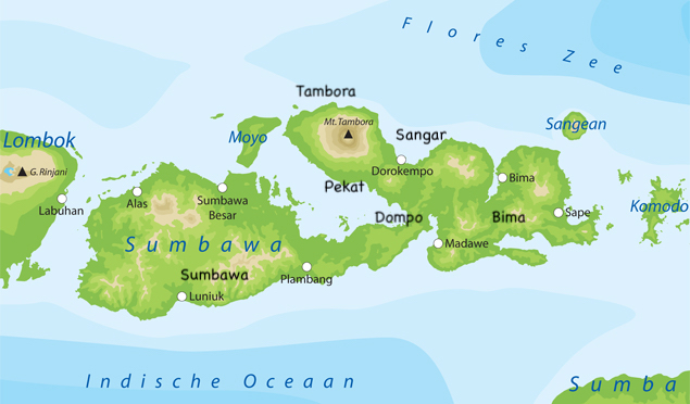
In between Lombok (the location of infamous Rinjani) and Flores (with the magic lakes of Kelimutu) is the island of Sumbawa. It lies in the heart of the most volcanic region of the most volcanic nation on Earth. The two largest eruptions of the last 1500 years both came from this region. Lombok has never fully recovered from the 1257 eruption of Rinjani. Sumbawa still carries the scars of the 1815 eruption of Tambora.
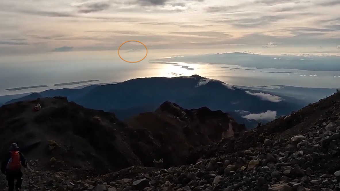
To illustrate the importance of this region for major eruptions, Tambora is visible from the peak of Rinjani, even at 160 km distance. I recently saw the direct evidence of this when coming across a video of a Rinjani climb. The screenshot below is from the peak of Rinjani: unnoticed by the climbers, the blob on the horizon is exactly in the direction of Tambora. This single shot contains the two most powerful eruptions since the demise of the Roman empire!
Sumbawa is littered with volcanoes. In fact the island is mainly a collection of volcanic mounts. But one dominated over all others. Even after self-destructing in 1815, Tambora is still the highest mountain of Sumbawa.
The Tambora eruption is the largest eruption with historical records, i.e. in modern times. This is in spite of the fact that no one who saw the actual explosion survived, so much so that we do not even have a record of what the mountain looked like prior to the eruption. The impacts fundamentally changed Indonesia. It also gave us the first indications that large eruption affect the climate worldwide – even though that was only recognized a century after the eruption. (It is in a paper by Jacques Redway, Ecology, 2, 104 (1921), https://www.jstor.org/stable/pdf/1928922.pdf). Krakatau may be better known, but Tambora’s eruption was between five and ten times larger!
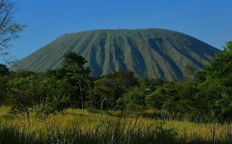
Tambora’s remnant is 2850 meters tall, with a 6-km wide and 1100 meter deep caldera at the summit. We know very little about what the mountain looked like before the explosion. It may have been dormant for 5000 years, in which case it must have been quite eroded, but much of the shape was probably hidden underneath dense forests. The original surface is now buried under the 1815 deposits. We don’t know how high the mountain was either. There are estimates based on putting a cone on top but we don’t know whether there ever was a high cone. The mountain was a notable navigation point, visible from afar, but it never attracted anyone to actually sketch or paint the mountain. I therefore expect it wasn’t pretty – no Fuji-like cone, and it may not have been as high as often assumed. I won’t put numbers on it though – yet.
Why are these two VEI-7’s both here? It is hard to know why this region goes for extremes. Lombok and Sumbawa differ from the large islands of Sumatra and Java in that they are build on oceanic crust. The continental crust of southeast Asia extends into the Sunda Shelf, which ends between Java and Bali, just before Lombok. All three islands off the shelf, Bali, Lombok and Sulawesi have one or more large calderas. There is even a next one in the sequence: Sangean Island, east of Tambora. But whether there is a rhyme and reason here, or just coincidence, is unclear.
Eruption
We have previously discussed the impact from the Tambora catastrophe on the climate, which itself changed the western world: see https://www.volcanocafe.org/tambora-the-lost-summer-and-the-hobby-horse/ The following description of the eruption is taken from there:
The trouble began on April 5, 1815, when distant cannon fire was heard. Indonesia had become British in 1811, to prevent the French from taking over; Sir Raffles, the governor in Java, send a regiment of troops to investigate the attack. No enemy could be found. The next day, some ash was falling and the sun appeared as in a fog. It was evident that a volcano had erupted, but no one knew which one. Earthquakes were felt in the east of Java on the 11th, and the Sun darkened further: visibility was reduced to 300 meters. On April 12, the morning in Batavia was late. People woke up in darkness, unsure of the time, and breakfast was held in candle light. The darkness began to lift a little by 10am, by which time the first birds finally began to chirp. The sun became faintly visible only by the end of the day.
The unknown culprit was more than 500 km away, to the east. Tambora had only recently revealed itself to be volcanic. Three years earlier, people living closer to the events first noted that Tambora had acquired a summit cloud which the wind would not disperse. Later, occasional thunder was heard. In 1814, a ship which passed close to the coast reported significant activity at the mountain. A cloud of ashes blackened one side of the horizon, looking to the world like a threatening tropical squall. In fact, it was mistaken for one and the commander of the ship took in sail, and prepared to encounter it. On approach, the real nature of the phenomenon became apparent, and ashes even fell on the deck. The stories finally reached Batavia, and a Mr. Israel was dispatched to investigate. Mr. Israel reached Tambora on 9 April 1815. He did not survive.
The eruption had two main explosions, on April 5 and April 10, with the second one being much larger. The first report of ash fall is from April 3, with early explosions perhaps on April 1 according to a single report. It is possible there was a minor event at that time. On April 5, the explosions were heard throughout much of Indonesia, between 6 and 8 pm. The sounds were compared to cannon fire. There had been several smaller explosion earlier in the afternoon, reported only from Sulawesi. Ash fell in Java on the next day, and the sun became hazy. Whether anything happened over the next few days is unclear. Raffles mentions that explosions were heard on occasion during that time (and remember that he was in Java, far far away) but other reports don’t mention this, nor do we have ash layers from those explosions. So far, this was considered a noteworthy but not remarkable eruption, from an unknown volcano. The people had known eruptions like this – ash falls in Indonesia are not frequent but neither are they uncommon. It might have been a high VEI-5 or even low VEI-6 at this time, but this is guessing.
It all changed in the evening of April 10 when the eruption resumed with a vengeance. From 10pm, the explosions again were heard across Indonesia. As far as central Java tremor was felt in the ground and the houses shook. Whether these were earthquakes is unclear: the ground may just have been responding to the air pressure waves. Ash fall became intense, and even in East Java a depth of 20 cm was reported. One of the many, frequent explosions seemed even more violent than the others. The explosions continued until the following morning when they slowly began to reduce. The ash became so dense that the sky darkened and the day was as night. Bali was in darkness on the 11th. The darkness reached Java late afternoon on the 11th. It remained dark until the afternoon of April 12. Close to the eruption it stayed dark for days. The sun did not return until April 14.
Now the eruption was unique – no one could remember anything like this. And still the source of the eruption remained unknown. Reports came in of a tsunami in eastern Java, although strangely this was dated to the evening of the 11th, long after the main eruption had ended. This was at low tide, so that the 1-meter rise in the tidal river did not cause damage.
Ships managed to approach Sumbawa by the 19th of April. Large mats of floating pumice had made travel very difficult. Only now was it becoming clear that the mountain at fault was one no one had been suspecting: Tambora. The town of Bima, almost 100 km from Tambora, was found to be largely destroyed, with the port damaged by a tsunami. Closer to Tambora the devastation was complete. Throughout Sumbawa, villages were found to be abandoned with houses collapsed and people searching far and wide for food.
On April 22, a ship came close to Tambora and mentioned that from a distance of 10 km, the summit of Tambora was not visible, being enveloped in clouds of smoke and ashes. They also noticed lava streams which had come down the mountain, especially to the north northwest. There are two obvious comments here. The lava stream was likely one of the pyroclastic flows, and the summit was invisible because it no longer existed. It is strange that no one commented on the change of appearance of the mountain!
Around Tambora are several additional craters, including on the coast. They may predate the eruption, but it is also possible that they are places of later explosions, where the hot ejecta met swamps or other wet places. There are reports that explosions continued until mid July. That is the start of the dry season, and it is plausible that the explosions after April 12 were caused by the monsoon.
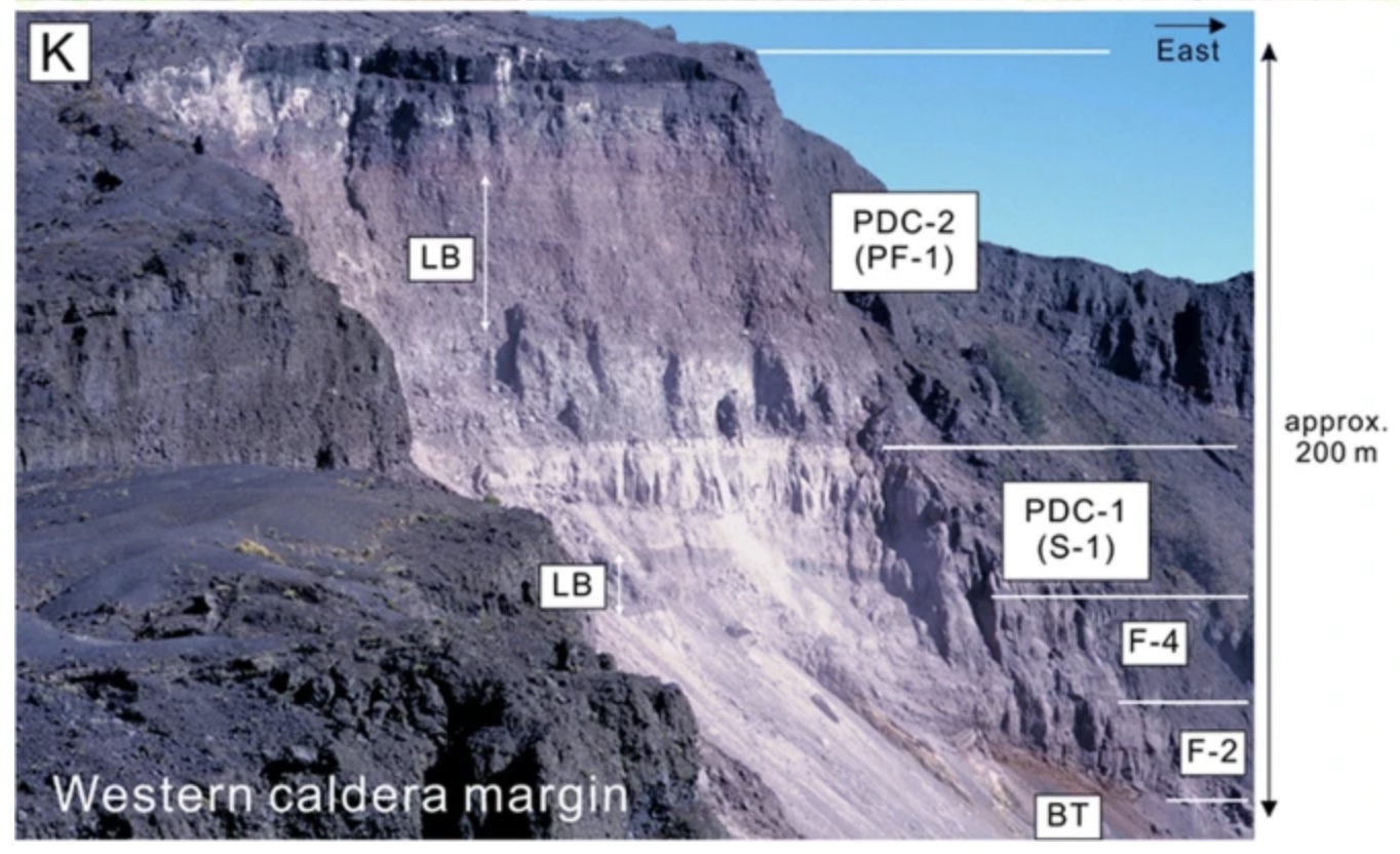
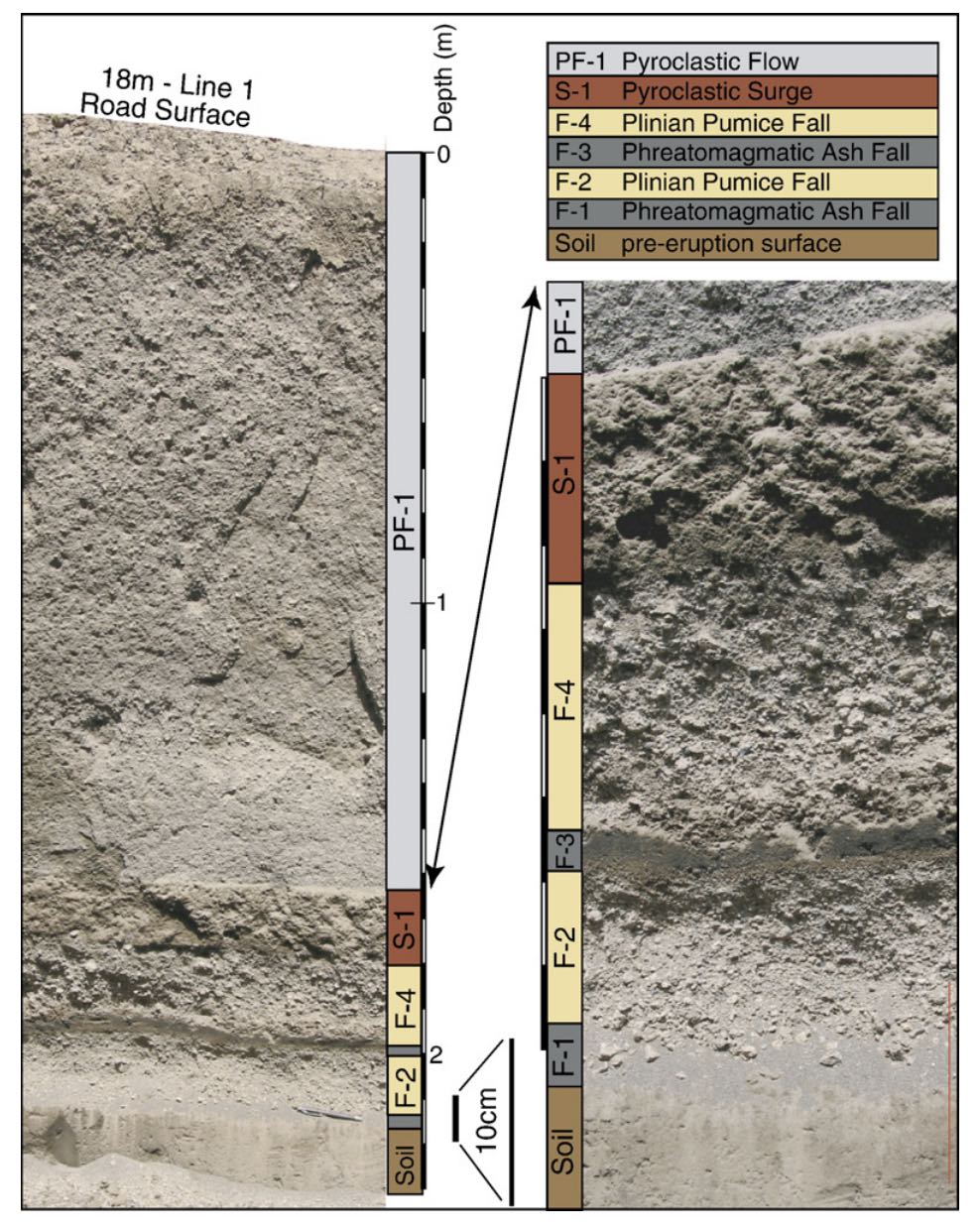
Deposits in the crater wall. The bottom layers, F-2 and F-4, come from the eruption phases on April 10. S-1 and PDC-2 are pyroclastic deposits from the end phase of the eruption. Total thickness of the layers here is 200 meters. Source: Suhendro et al 2021, Bulletin of Volcanology. https://link.springer.com/article/10.1007/s00445-021-01484-x
It is remarkable how little we know. The height or shape of the mountain before the eruption was not known. It is not known after the eruption either. The singular 6-km wide crater shows that the main eruption was a single explosion, but there is only one mention of a largest blast, on April 10 or 11. There is only one description of the main eruption, from a Rajah around April 23rd. This mentions three pillars of fire from the summit. But is unclear whether this description refers to April 10 or to April 5, or even whether it is correct. It is one comment, reported second-hand. There is a lot of speculation based on this single observation but it must be considered as unconfirmed. We just don’t know.
Tambora before the eruption
Tambora is thought to have been inactive for a long time before the 1800’s. This is reasonable for the 1000 years before the eruption, as there was no history of Tambora being a volcano. There are some 20 parasitic cones, some near the coast, but those also must be old enough to predate human memory. But we don’t know the pre-1815 history well. There is no date for the last eruption before the big one.
Satonda Island, a small lake-filled volcano just north of Tambora, has been studied as a proxy for Tambora itself. The island is 2 km off the north coast of Tambora, is 2 km across and the lake is a double crater. It erupted similar lava and as such is Tambora’s nearest relative. Radiocarbon dating suggests it’s most recent eruption was 4000 to 5000 years ago. This is often taken as the date for the most recent activity of Tambora, assuming that the two are closely related and Satonda is in effect another parasitic cone. The crater lake is surrounded by a double tuff ring. The lake was fresh water at first but around 4000 years ago the tuff ring was breached and the lake became salt water. Some time after that, the island inflated by around 1 meter, causing part of the bay to fall dry. This happened after 300 BC. Was this the inflation that heralded Tambora’s activation?
What caused the eruption? We don’t know. The magma chamber was located roughly 4 km below the surface. The magma had been sitting there for a while but with little cooling. The earliest eruption on April 5 erupted the hottest ejecta. This also contained little fragmented rock, suggesting that it did not blow a large crater. This situation also prevented significant pyroclastic flows. The second phase came from deeper magma layers with slightly lower temperatures but also contained more rock fragments: the hole had become much larger, which leads to lower pressure in the rising column and destabilizes it – the column can now collapse and produce dense pyroclastics. These pyroclastics wiped out much of the island, reached the ocean and caused tsunamis. The pyroclastic flows reached perhaps 40 km distant. But this does not say what triggered the eruption. A possibility is that water had managed to get into the magma chamber. And why the activity in the three years before the eruption? And did the inflation at Satonda Island indicate a major recharge of the magma chamber? That also is not seen in in the ejecta. But it seems like the magma chamber wasn’t that old. Tambora was not a volcano at the end of its life cycle. It may still rise again from the ashes.
Tambora exploded some 150 km3. This number was first derived by Verbeek, the same person who first pointed out the danger of Krakatau, several years before it erupted. The height before the eruption is often said have been 4000-4300 meters, but a recent reconstruction of the pre-eruption reface suggests it may have been less than that, 3500 to 3700 meters. The mountain may have had plateau with a number of separate peaks rather than a single high cone. This would fit much better with the (lack of) pre-eruption records. Note that Tambora is not that close to the coast. A flatter shape would have made it a useful navigation feature, but not a notable mountain. It would still have been one of the highest mountains in Indonesia, but not the highest. A plateau-like shape excavated to a depth of 1800 meters would be consistent both with the post-eruption caldera and with the 50 km3 (DRE) ejecta.
History
Sumbawa is one of the larger islands of Indonesia. It is some 250 km long. Tambora is situated on a peninsula on the central northern coast. The mountain has long been known but the names have changed over time. In the 1500’s, when Rinjani was called Anjani by the Portuguese, Tambora was known as Mount Aram. Anjani’s name was similar to the current one, but Tambora’s was not, suggesting the Portuguese did not know the local name. It was impressive enough for them to give it a biblical name.
The name ‘Sumbawa’ was originally only the western part of the island, and was called Sambawa, a name derived from hinduism. The island was converted by force from hinduism to islam around 1620 but the names still show the pre-islamic influence. Because the conversion was by force, the people became slaves of Makassar (Sulawesi). The only exception to this was Sangar which remained free (or rather ‘vassals’).
There were six subjugated kingdoms on Sumbawa, with approximate locations indicated below. The kingdoms were mainly small towns located on the rivers and near forests. Trading was done mainly through Bima, where rice was an important export product. The island was also known for its sapan wood (sandal wood) and for its horses.
Two of the small kingdoms existed around Tambora: Pekat (also known as Papekat) on the southern shore of Tambora and Kengkelu (later known as Tambora) on the northern shore. The peoples had different origins. The language of the people at Bima came from Flores, to the east. The language of Sumbawa and Dompo came from Java, to the west. The language spoken at Tambora and Pekat was very different, and may have been a Papuan language. The people of these areas were also said to have had a different physical appearance.
There is indeed evidence for some sort of early trade between Papua New Guinea and eastern Indonesia. Bananas were first domesticated in the highland of New Guinea around 7000 years ago, and from there spread to eastern Indonesia. Different banana species occur in the mainland of southeast Asia, which were domesticated independently but later. The word ‘muku’ for banana is of New Guinean origin: it is used in those areas in Indonesia where this early banana arrived. There are many other words in use across southeast Asia for various types of bananas, of which the Malay word ‘pisang’ is probably the best known. The word ‘muku’ was used as far west as Flores. Tambora used the word ‘much’. The population of the Kingdom of Tambora may thus have been the westernmost point of the New Guinean spread. The spread happened before 4000 years ago.
Did the Tamborians come from New Guinea, 4000 years ago? And did they survive for 4000 years in this isolated pocket on the north side of Tambora? The location was a good but isolated one: the mountain slope provided fertile ground, away from the mosquito-ravaged coast but in reach of northern trading routes, while protected by the mountain from the people to the south. After such a long time, it is likely there would have been mixing with the people of the other kingdoms or the trading partners, but evidently the appearance of the people was still different. But after all that time, the very mountain that protected them would become their nemesis.
Impacts
In one week, between 5 and 12 April 1815, the region went from relative wealth to complete devastation. All of Sumbawa was buried under ash, meters thick around the slopes of the mountain (hundreds of meters at the summit) and 20cm or more even at the corners of this large island. The typical depth was 50 cm. The north shores were also damaged by a tsunami which reached 4 meters high around the mountain but which was measured around of Indonesia. It seems surprising that an eruption at the top of a mountain several kilometers high and 20 kilometers from the coast can cause a large tsunami. The likely cause is debris flows entering the water. Atmospheric pressure waves from the explosions may also have played a role. Pyroclastic flows killed anyone within 20 km of the summit, and many further away. We don’t know how many people lived there: estimates made shortly after the disasters put it at 10,000. But that was only the beginning.
Chasse, who visited Sulawasi in 1816 on a fact-finding mission, writes ‘People still have little and insufficient information regarding the devastation which the volcano of Tambora has caused in 1815. The assumption is that the kingdoms of Tambora, Sangar and Papeka are fully destroyed and buried by lava, while the famine afterwards at Bima, Sumbawa and their surroundings has been so bad that many have died and others have fled from hunger to here.’
That is indeed what happened. Everything was buried in deep ash. People started to die of the impacts of this. Breathing in volcanic ash can be highly damaging: some people will have died of this. A plague of diarrhea began affecting not only the people but also the animals. Clearly, the water had been polluted. We don’t know by what: was it decaying organic matter? The abrasive ash itself? The suggestion has been made that it was a more common volcanic product: fluorine, an element that can occur in volcanic ejecta and was a major cause of fatalities in the Laki eruption. We don’t know, but it suggests that if we ever have another volcanic disaster, the first priority may be to provide clean drinking water. Up to 75% of farming animals died in this epidemic.
There was no food: everything was buried, inedible, and not growing. The top of palm trees provided some nourishment. People fled from hunger and started to scour the land for anything edible. Many fled to Bima, also badly affected but not buried as deep because of the prevailing winds. Others sold themselves into slavery on the other islands and in that way saved their lives. But that was not possible on the main islands (Java and Sumatra) because slavery had been abolished.
These other islands though were also affected. Already in April, a report from south Sulawesi says that there was 3cm of ash (one and a quarter inch, to be precise, but at this time the inch was not in fact precisely defined) with damage to the rice crop where the still young plants were fully buried, fish in the fish floating dead on the surface and many birds killed. Lombok and Bali were badly hit with 20 to 30 cm of ash. All their rice plants were killed and the people became completely dependent on rice from Java but without anything to pay for the rice. A report from Bali in 1816 stated that the survivors were too few and too weak to even bury the dead. This caused further epidemics. The poverty extended the famine which lasted into the 1820’s. Lombok had a population estimated at 200,00 before the eruption. This may have reduced to 70,000, although no hard number exists and we do not know how many died and how many fled. The death toll on Sumbawa and Lombok combined was given as 92,000 although again this number is very uncertain. The death toll on Bali was reported at the time as 25,000 and this is normally not included in the total reported toll.
But Sumbawa was affected the worst. The Kingdoms of Tambora and Pekat were fully wiped out, with the sultans among those who died. The Tamboran language, history and culture was no more. Elsewhere, most houses would have collapsed. The entire rice crop was destroyed. People sold everything including their children for food: one child could go for as little as 3 kg of rice. There may have cannibalism, and epidemics quickly took hold. The King of Sumbawa succumbed to disease. The population of Sumbawa was estimated as 170,000 (this is little more than a guess though). After the eruption, fewer than 90,000 were left. Perhaps 35,000 had fled the island. It took a long time to understand the scale of the disaster. The British send a single ship to help. It could do very little. (In fact, sea travel was difficult because of the large mass of floating pumice which took up to 5 years to disperse.)
Recovery
Recovery took many years. Bali and Lombok found that the land had become more fertile, and after some years the rice crop began to increase as a consequence. This started in the late 1820’s and continued, so that by the 1840’s Bali provided much of the food of Singapore. Sulawesi similarly saw a good recovery.
Flores was affected differently. There had been many deaths (we don’t know how many) but there was an unexpected change. Western Flores had been conquered by the Kingdom of Bima and paid a large tribute to them, in chicken, dogs, horses, people (slaves) and other produce. Bima was no longer in a position to enforce this, and so Flores stopped paying. This benefit lasted until the 1850’s when Bima had recovered sufficiently to re-establish the old dependency.
Recovery was considerably slower on Sumbawa itself. The first improvement was on the mountain sides, where erosion removed the ash quicker than elsewhere. Villages moved up-slope. However, this was only possible after 10-20 years. On the slopes they started growing dry rice, rather than the previous wet rice cultivation of the lowlands. They kept their traditions, showing these were the survivors, not later immigrants. It may well have included people who had fled and now returned. In the least affected part of Sumbawa, the east, the first harvest took place 5 years after the eruption. In the west it took much longer. The forest was destroyed or inaccessible, removing the main export product, sapan wood. After the eruption, the local climate had changed. The surviving inhabitants told investigators in 1847 that it had become much drier than before. The cause may have been the loss of forests, which would have reduced local humidity, and perhaps the reduction in the height of the main mountain had affected the monsoon! But most likely is that the rain water now flowed underneath the thick ash and was invisible and inaccessible.
The region of Tambora was visited in 1819. It was described as ‘horrifying’. The ground was cracked and fissured, and travel near impossible because of ash and tree trunks. Bima was in better shape. The people lived mainly on the coast, avoiding the hilly in-land. The first crops gave plenty of food, in part because not many people were left to eat it! Trees here had survived but there were no people for logging. The town of Bima was described as ‘derelict’. Few horses had survived – previously Sumbawa was known for its horse breeding. By 1824 the Kingdom of Sumbawa had also begun to recover, but Tambora was still described as ‘a heap of rubble’. And only in 1844 do we have the first record of people returning to Sanggar.
Heinrich Zollinger visited Sumbawa in 1847 and gave the first comprehensive report. He noted that much of the forest had been replaced by grassland and that much of the wet rice fields remained abandoned. Livestock used these for grazing, preventing the forest from returning. Bima had largely recovered, and even the horses had returned.
Tambora was climbed for the first time (as far as records exist) by Zollinger, in 1847. The mountain was still largely a rubble field with few plants and animals. The crater lake was seen for the first time. By 1913, small forests had returned as high as 2500 meters and there was now some sparse vegetation in the crater. A report from 1933 states that from the
lowlands to the peak, after an initially barren, dry landscape, they entered a ‘mighty jungle’ of ‘forest giants’. Higher up they found a shrubland and the summit was barren with a few Edelweiss.
The re-greening had continued by 1947 but even at this time there was little vegetation at the bottom of the crater. It was suggested that the numerous fumaroles especially on the west side made condition too hostile. An article in the Smithsonian describes the view from the crater rim: Three thousand feet deep and more than three miles across, the crater was as barren as it was vast, with not a single blade of grass in its bowl. Enormous piles of rubble, or scree, lay at the base of the steep crater walls. The floor was brown, flat and dry, with no trace of the lake that is said to collect there sometimes. Occasional whiffs of sulfurous gases warned us that Tambora is still active. https://www.smithsonianmag.com/history/blast-from-the-past-65102374/
The wild life remains limited on Tambora. This is notable in bird species, where several common species elsewhere remain absent on Tambora. This is likely caused by the 1815 eruption. During the recolonisation, the early birds got the worm and the latecomers found their niche already occupied.
There have been small eruptions in the crater. A small cone erupted short lava flows at an unknown time, possibly early 20th century. There is also a small lava flow visible on the inner caldera wall which looks quite recent. But in the main, this is just a dreaming mountain. For all appearances, it looks like Tambora has finished. Whether it will restart its growth will not be known for centuries or even for millennia.
Archaeology
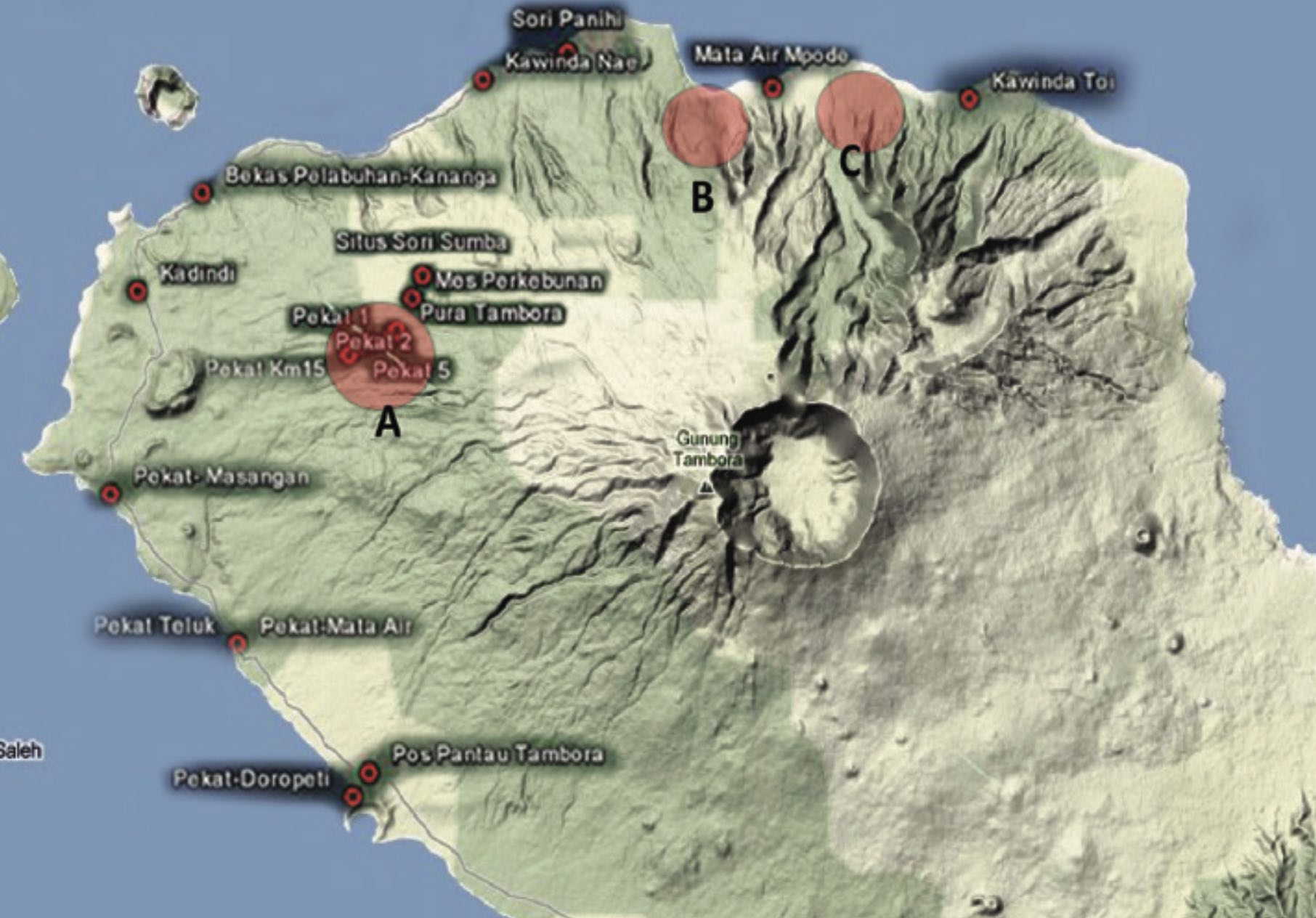
Very little was known about the Kingdoms of Tambora and Pekat. That began to change only in 1980. A logging company was digging a new road (illegally) through uninhabited, very dense forest near Tambora village, 20 km northwest of the summit. This new forest had by now become an important source of timber. The diggers found a large amount of man-made material; they gathered that it was archaeological because no one had lived there since the eruption. The remains were in a layer in between the 2 meter of volcanic deposits on top and the brown, pre-eruption soil below. Michael Hitchcock investigated the site in 1980 and 1982. Pottery fragments were found to include Chinese material, but with the glazing partly melted away. Coins that were found had been kept by the loggers, but they were shown to investigators. All were Dutch and dated to the 18th century. The latest was from 1791, more than 20 years before the eruption. Was the village abandoned at this time, or was it because of the Dutch trade disruption after the French revolution?
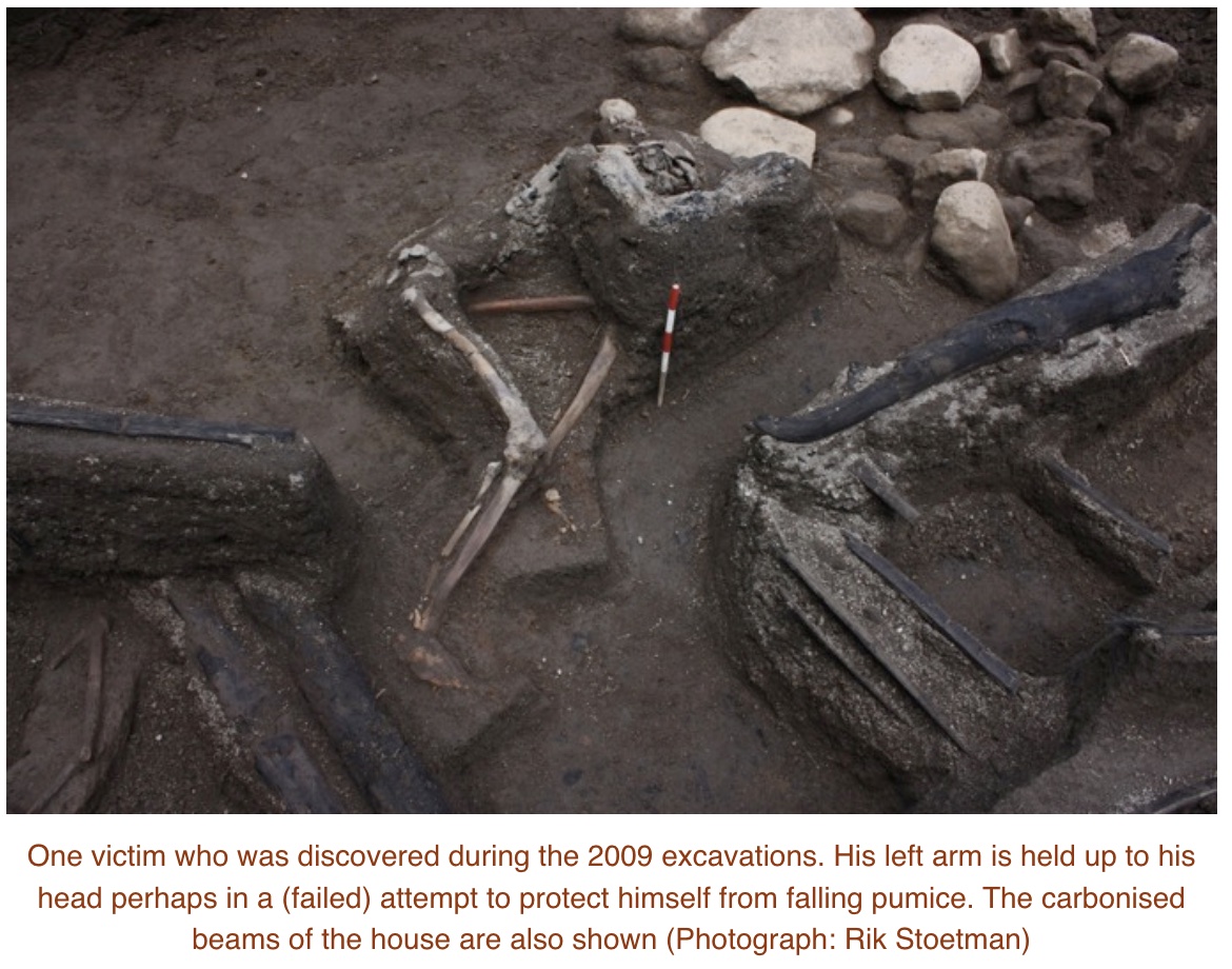
Full excavation started in 2004 and is still continuing. Not much has been published on this continuing investigation, but some descriptions have appeared. The first buried house was found in 2004, underneath 2 meters of ashes. Since that time, at least 4 more houses have been exposed (as of 2011).
The village contained several houses, in a line along what was probably a road. The houses appear to have been of similar design to what is still found in Sumbawa, build from bamboo. Several of the houses contained skeletons, in one case of a man sitting up with a ceremonial sword at his side. The bronze objects and jewels suggests that the people were quite wealthy. The various objects show a link to Vietnam. The wooden beams of the houses are burned: the ash that buried the houses was very hot. It appeared that the people stayed in their houses during the first phases of the eruption on April 5. They died when the houses collapsed under the weight of the ash and stone fall on April 10, and afterwards the hot pyroclastic flows burned the houses and the human remains.
The layering of the volcanic deposits in the area were published in 2007. The layers show the various eruption phases. Layers F1 is probably from the initial eruption on April 5. At this time, the people stayed in the houses. This is probably because the ash layer was initially manageable. The cataclysmic eruption came on April 10, with layers F2-PF1. This eruption came at night and provided no opportunity to flee. The top layer is a double pyroclastic flow, 4 meters deep – and this was 20 km from the summit! The people died in their houses.
Museum Gully deposits. Abrams and Sigurdsson, Journal of Volcanology and Geothermal Research, Volume 161, Issue 4, 1 April 2007, Pages 352-361
The bottom of the profile shows the pre-eruption surface, where people lived. This surface is terraced, which indicates human activity, such as agriculture. At the very top was the layer of new soil, on which the new forest had grown. This humus layer was only 5cm thick! This explains why recovery was so slow here – the old soil was deeply buried, and new soil took a long time to form in this devastated land.
There is evidence for three areas of settlement around Tambora, from pottery remains. This one is furthest in land: the other two are closer to the coast. All are near springs or water courses, and the suggestion has been made that this indicates irrigated paddy fields. The coastal sites tend to be near harbours, although no longer usable as such since the eruption.
source: http://forumarkeologi.kemdikbud.go.id/index.php/fa/article/view/38
Clearly the land has changed. It was more cultivated and the people wealthier, than the old records mention. This was not an isolated tribe: it was a group trading far with contacts in Vietnam, and able to obtain Chinese pottery. We know so little about them because they were wiped out with little trace. But they were an integrated part of a wider society. This is Indonesia’s Pompei – a people well off, in their cultural prime, suddenly wiped out by a disaster they could not have seen coming.
Lessons
What can we learn from Tambora? It is hard to know where to begin! We have not had an eruption anywhere near this scale for more than 200 years. What if it happens again? There are questions that need answers: would we have warning and would we recognize the signs of an impending VEI-7? Could we evacuate in time? And what would the rescue and aid look loke?
As for the signs, we really have little idea. The Hunga Tonga eruption came completely out of the blue. Pinatubo gave us 6 weeks notice, and recognizing the signs and taking precautionary action was one of the greatest achievements of volcanology in the 20th century. It prevented major loss of life. Krakatau had been erupting for several months but became dangerous only in the weeks leading up to the big one. We know that Tambora re-activated with a minor eruption 3 years before blowing up, and that there was volcanic activity in the year before the end. But we have no idea whether there were other signs. There must have been, but no earthquakes were reported and no other precursor event was noted. Was this a lack of communication or a lack of warning? Old volcanoes have a temper: they can explode quite suddenly. But one would expect inflation and perhaps drying up of ground wells in consequence. Verbeek noticed something worrying at Krakatau several years before the eruption, but never said what it was. But if there are recognizable signs, what can be done? A small area can be evacuated but evacuating an island the size of Sumbawa is impossible. How could one evacuate Naples? Tambora might even present a worst case, with a largish eruption first, so aid would be rushed in, to be met with a much larger explosion wiping out the area.
After the event, what could be done? Now, evacuation is essential but roads are impassible, ports wiped clean by a tidal wave and airports deeply buried. It could take weeks to reach the people most at need. From the experience of Tambora, the priorities would be to provide clean water and to bury the dead – very deep. In fact, cremation would probably be considered as an emergency measure. Where would the water come from? It would need to be brought in as plastic bottles, one or more per person per day.
Food would be next. Here we are probably set up better, with the UN having significant experience in alleviating famines all over the world. However, this always depends on access to the region. Even weeks after the eruption, this might be very difficult.
And then there are the refugees needing new homes. They could run in the millions, depending on where the eruption was. And after this, the slow recovery, taking decades.
Prevention is always preferable. We can’t prevent eruptions – but we can prevent some of their impact. Monitoring of volcanoes under suspicion is essential. It will take time to learn what the danger signals are. But learn we must, if we want to be ready for when it happens. The dark night of Tambora is our wakeup call – the lost Kingdom of Tambora our warning. Are we ready?
Albert, September 2023
Gunung Tambora – the mountain with the missing top
(The following addendum is entirely made up)
Excerpt from the VC post ‘Looking back at Rome’, 12 August 2063
It is now 30 years since the dramatic events at Lake Albano, or the Gandolfo eruption as it is now known, named after its first notable explosion. We remember how the activity started in the mid 2020’s, first with an unexplained rise in the water level which led to the exit tunnel becoming filled again. The earthquake which later collapsed the tunnel was unforeseen and now the lake began to flood. Some expensive properties build too close to the water were lost.
When the water temperature began to rise, the first suspicions of volcanic activity were raised. Scientists pointed out that Rome itself was build on the ash from the two volcanoes on either side. But these had not erupted for a very long time and were thought safely extinct. This attitude continued even when fumaroles developed on the crater rim, and air quality at the town of Castel Gandolfo got so bad that people started to leave.
A small eruption on the lake shore occurred in early 2031. After that, the lake stopped rising and even started to go down. The scientists pointed out that this was due to extension of the crater, which improved drainage but this fell on deaf ears. No further eruption occurred over the next two years, and it was felt that the event was over. Tourists flocked in to see the new small crater on the lake.
The VEI-5 explosion on July 12 2033 came therefore out of the blue. In hindsight, there had been warnings, such as the increase in gas emissions. At times a plume was seen rising kilometers above the lake. But in late spring when air temperature rose, the plume had disappeared. The overnight explosion destroyed Castel Gandolfo with significant loss of life, and deposited centimetres of ash as far as Rome. It was heard across Italy. Aid quickly came. A meeting was called by the government for the following week to discuss the event. This meeting was overtaken by events and never happened.
On July 16, explosions followed each other in rapid succession and people began to flee. Evacuation of the region south of Rome was ordered but quickly found to be impossible. Naples had been prepared for such an eventuality. Rome was not. Three hours later, the dramatic VEI-7 explosion followed which obliterated the area, formed a crater 6 kilometers wide and dropped 20 cm of ash and stones on Rome, 25 km away. A few hours later the eruption column collapsed and the pyroclastic flows came down the hill sides unto the plains. Luckily the wind pushed the material eastward, but much still reached the city. Buildings collapsed under a meter of ash. Even now, 30 years later, much of the area south of Rome remains uninhabited and many buildings in Rome are badly damaged.
Much has been written about this eruption, the destruction in Rome, its effect on Italy and Europe and its impact on climate. But one question remains unanswered. While all the attention had been on Naples, why had the volcanic landscape of Rome been ignored? Why had no one seen this coming?


Serendipitously, I was reading about Chichon this week, in which its 1982 eruption seems like a miniature Tambora. Even more so, after reading your description of the 1815 eruption.
Hunga Tonga showed that it can come from anywhere…….
Those massive Rhyolite and trachyte volcanoes in east African rift are overdue… .. In fact the entire region is overdue.
You cannot, I repeat CANNOT, legitimately say a volcano or even a whole group of volcanoes are “overdue” an eruption.
That implies predictive power we simply do not have. Impossible currently and likely impossible for the foreseeable future. You can only talk in terms of probabilities of eruption: a very, very different thing.
Probable until the volcanoes in question change behaviour.
Of course you can say a volcano is ‘overdue’ when there are clear signs of large scale activity building at present and the area has a known history of producing very large eruptions at very broadly regular intervals, its all statistics. What cant be known is exactly when it will happen, or exactly how big the next eruption will be. On the timescale of years the volcanoes are unpredictable but at longer timescales they are almost completely predictable. Corbetti caldera has for a long time been inflating very significantly, it is a large rhyolitic caldera with capability to do a VEI 7. Will it? Probably not, it has two post caldera rhyolite lava shoelds, but even just the vent clearing stage of one of these erupting could be a disaster.
The Ethiopian Rift does not make eruptions at regular intervals. The youngest caldera-forming events from some of the largest calderas in the area were all tightly clustered in time making a flare-up:
https://www.nature.com/articles/ncomms13192
‘Overdue’ or not, the rather limited monitoring in many places in Africa means important early warnings for any major event might be missed making damage and loss of life mitigation far harder.
Hi, excellent article. About the shape of Tambora before the 1815 eruption, Zoellinger reported that it was conical with two peaks, in page 11, thanks to natives.
https://www.google.it/books/edition/Besteigung_des_Vulkanes_Tambora_auf_der/W3FBAAAAcAAJ?hl=it&gbpv=1&dq=zollinger+tambora&printsec=frontcover
In the past, there was a discussion about this topic.
So, Tambora had the shape of a cone, but with two summits, not of a plateau with multiple peaks. The question is: Were these two summits two distinct craters, or two peaks of a strongly eroded crater?
The height, instead, should have been at least 3700 meters.
I find the scanned version at Linda Hall Library easier to read than the google scan. (https://catalog.lindahall.org/discovery/delivery/01LINDAHALL_INST:LHL/1290367390005961). Zollinger states twice that there was a double peak but gives different reasons. I don’t think it is the full story. One reason he gives is the fact that the crater is elliptical, and he assumes there are in fact two overlapping craters, from two original peaks. That is clearly wrong. The mountain is slightly elongated north-south, and so the round crater became a bit larger in the east-west direction. The other reason is a recollection from Bima that there were two high peaks. But no one else ever mentioned it, Bima would be very far away to see this and east-west separated peaks (as Zollinger argues) would be seen as a single peak from the direction of Bima, unlike a north-south separation (which Zollinger also mentions). A recent DEM model of the mountain finds a profile that flattens towards the summit, pointing at a lower pre-eruption height. I find that quite plausible. A flatter top with several smaller cones would in fact fit many constraints. True double peak volcanoes are not uncommon but tend to be a bit further apart then just a few km. Flattened volcanoes with multiple peaks are also not uncommon but those peaks are not as high. This remains unknown. The shape of the caldera shows that it was caused by a singular main event, not a double one.
Weak sauce is overselling “One reason he gives is the fact that the crater is elliptical, and he assumes there are in fact two overlapping craters, from two original peaks.” Tambora’s crater is within 10% of being a perfect circle. You’d be hardpressed to find a volcano who’s remaining structure less implied anything complex was going on structurally.
I’m sort of doubtful it had multiple peaks or a notable plateau. There is just very little to suggest that in the surviving slope up to the rim. Very, very similar to how slopes around Rinjani’s surviving peak look in sides away from the caldera/former 2nd peak. That would lose 1.4 km in height if you took a Tambora-size circle out of it.
Someone (I think Daredevil) in comments from the past argued that, according to an Indonesian geological map and the Zoellinger’s report, there was two craters, an older one to the west and a more recent one to the east because volcanic products, before only at west, at some point, began to be present only at east, except that the last came from by west. Maybe only one peak/crater produced the 1815 eruption. But the shape of caldera looks like regular enough, as Reykvolc observes; so, another question could be: two different craters/peaks, even if separated from a short distance, could produce such a “perfectly” circular caldera?
Then the rajah speaks of three columns of flames coming from near the summit, apparently from the edge of the crater, more or less textually, it doesn’t matter if the description is referred to the eruption of 5th or 10th. Apparently, this agrees with a Fuji-like conical shape and the conical (kegelberg) description of Zoellinger, but why to say “apparently? Maybe the adverb is the key?
In my opinion, it’s fundamental a confrontation of this caldera to the similar ones for geological region, volume, both erupted and remanent, like that of Rinjani, considering the description.
Yes, based on the morphology of the volcano there would have been two main edifices in the summit area, plus the oldest one that makes up the north flank. 1 is an old, deeply dissected volcano. 2 possibly makes the bulk of Tambora itself and is shallowly dissected. 3 is uneroded lava from long-lasting effusive eruptions of fluid basaltic-trachyandesites and trachyandesites. Presumably 2 formed a summit on the west side of the obliterated area, by the time of the 1815 it was probably eroded and did not form a cone but an irregular peak with canyons on the sides. 3 would have likely had a central vent somewhere on the eastern side, so yes, two peaks. One possibility is that 3 formed a tall symmetric cone, but I’m not sure caldera systems do things like this. I can see the possibility of 3’s vent being a low tuff cone sitting on an uplifted flat-topped dome coated in lava. Similar to how Yasur presently sits on top of the Yenkahe dome. I think the uplift and growth of the magma chamber must have taken place after 2 went dormant, and before 3 activated. 3 likely growing on the dome that had formed, but this is a guess of mine.
My best guess on how it looked before the collapse, may be wrong:
This is plausible. The highest points were more likely oriented NNW-SSE, based on the morphology. Note that the southeast section is so different in appearance in part because hot is the dry sector with much less erosion and regrowth. That also has kept some apparent lava flows visible, which may be related to the parasitic cones.
Hi Hector, that is a suggestive shape! The reconstruction is yours? I think it’s reliable, according both the conical shape and the two peaks. Or I wrong?
And it would have been a beautiful mountain, maybe not like a classic cone, but it knows its stuff.
In your hypothesis of a low cone stuff sitting on for 3, where it would have been the eastern central vent?
We’ve had this conversation before. Last time (as DustDevil) I brought up a geologic map that showed the west side is older than the east side, but I’m not really sure where to find the map now. I think the volcano should be better studied, for the last VEI-7 in the world, very little is known about its history.
This is a possible structure of the pre-collapse volcano, my favorite, but it could have been different too. For example, there could have been a caldera, or an infilled caldera at the top that simply deepened during 1815, like Hunga Tonga. Or the more straightforward option of a tall cone, like Rinjani.
That map is no longer on line, sadly. You may have been referring to the map in this paper
https://www.volcanocafe.org/wp-content/uploads/2023/09/Impact_of_the_1815_Tambora_Eruption_to_global_clim.pdf
You can also try https://it.wikipedia.org/wiki/Tambora for a discussion on the pre-eruption shape. It is in Italian, though.
The discussion was in the comments to this post: https://www.volcanocafe.org/white-island/
Supposedly it went caldera once before long, long ago, but couldn’t find anything about its size. Other than one source claiming it wasn’t 100% filled in pre-1815 and that effected the pyroclastic flows. Presumably would have been bigger though given predates the 1815 edifice apparently, supposedly 50k or so. Not sure where it would have been though, certainly doesn’t stand out on topographic map.
Does make you wonder too, if this is the correct interpretation of Tambora as being kind of like Etna and being mostly effusive, it likely would have been assumed the worst it could do would be to erupt a large lava flow at low elevation, thinking about if the events before 1815 had occurred instead in 2015. Although based on what I remember reading back then I think people would hear tthat its magma is something other than basalt and jump to the opposite end that it must have magma so viscohs it isnt even really a liquid so kaboom… it makes me haply to see how far this forum has come sometimes, from articles that basically paraphrased wikipedia up to stuff that I hope might even be getting actual volcanologists to go an investigate as a result. The standard has been raised quite enormously 🙂
But regarding Tambora, maybe Etna is actually a good comparison. Etna certainly isnt about to self destruct the same way, it has no suitable magma chamber and is basically a hole in the crust. But what if Etna did stop erupting for 1000 years?… for that I present, Fuji… Ges it has erupted more often than that but the cone is very large and symmetrical, but has only had flank eruptions for several millennia. It must have been highly active in the earlier part of the Holocene. Its eruption in 1707 involved dacite, so it sat long enough before then to evolve that, but it was still mostly basaltic, and despite that was a VEI 5 plinian eruption, probably a multiple km tall lava fountain, would have been quite the extraordinary sight. Fuji is also a nearly 4 km tall mountain with a quoted volume of well into the 4 figures in km3. Sounds like a candidate, although not one which poses an immediate risk right now.
Hell, even Hawaii could probably pull of a Tambora in the right conditions. Those conditions dont exist now but it seems magma viscosity is probably way less important in this factor than usually quoted. In fact, I would argue lower viscosity would be worse, the melt could flow faster, making tbe whole thing higher intensity…
Of course there us also Ioto, but I dont think I can one up the article that exists on it in one comment. 🙂
What are your thoughts on Ararat, Chad? That is one obscenely large mountain and over 5000m elevation though I’m unsure how high the surrounding land is (assuming something like 500-1500m?).
I dont know much about it, but it could be a candidate. Probably needs a study to confirm existence of a magma chamber though otherwise it can probably be discounted.
It is a huge mountain though, nearly all of the Anatolia-Caucus area volcanoes are, they arent numerous in numbers but seem to be huge mountains.
Chad, are you certain you were thinking of Ararat/Agri Dagi? Ararat has at least a handful of dated/historical Holocene eruptions. Were you thinking of Aragats in Armenia perhaps?
In every case, Albert, this DEM reconstruction is available?
DEM data should be public. The analysis is published as an abstract only: https://ui.adsabs.harvard.edu/abs/2016EGUGA..18.8916F/abstract
You could think of Vesuvius which prior to the big eruption was reported to have a flat top. That can be thought of as a crater which had been pushed up to the brim by the inflation below. If Tambora had a crater on top before 1815, that could have been seen as two peaks when viewed from a distance, and it would have meant the mountain was smaller than derived from the idea cone shape. This is just a speculation. If the mountain had been Fuji-like, it would have been talked about. Since it was generally ignored, somehow this mountain did not seem that exceptional to the old seafarers.
When I ggl Mount Tambora 17th century drawings (18th century mostly pops up with 1815) I get several examples of this. This looks like a wall. It probably – if it is Tambora at all – a depression in the middle. Could be you find s.th. better in Dutch.
Forgot link:
Forget it, wrong mountain. There must be a drawing with those Dutch sailors around.
Fujis 1707 eruption woud indeed be an extraodinary sight as Chad says the eruption crater is massive and is like a giant cone almost, these where a kilometers tall angry ligthning filled glowing orange column going up in a dark roof which mammatus hangs underneath that where weekly lit by the show and sometimes ligthning crawls through the anvil. Calbuco 2015 and Etna 2015 comes to mind althrough far more powerful at start probaly .. the craters from the eruptions are huge
Woud be a unsettling sight from Tokyo a hot orange sword going up into a dark sky plain
Excellent review of a total volcanic horror show.without which one of the most celebrated ‘ghost stories’ of the 19th
Century might never have been written. Both having had world wide impact across centuries.
In terms of Rinjani/Tambora it is impressive that perhaps the two tallest volcanos in Indonesia at the time blew their tops so close together. I’m suspicious though that other Indonesian mountains though went similar process, just further back. Like Batur’s giant caldera complex has a rim roughly in ballpark of 1.5km in elevation. Tambora would be almost exactly identical if you made that wide a hole in it as would Rinjini in the directions away from its surviving peak (basically had to be two twins or a large parasitic cone looking at elevation trends like Little Ararat but closer looking at elevation, surviving peak seems much younger based on erosion than the lower parts of the missing one). Bratan is closer to 1.3km rim, except for a high side, which makes me suspicious it once was Rinjani. Really they all seem roughly similar size adjusting for how big the hole is
I wonder if that is the normal life story of a volcano in the belt from East Java to Tambora. First a beautiful edifice, maybe with a major parasitic cone, forms. This should not be understated. It is a 4+km tall mountain. Just the above-sea portion of Tambora is easily 1000km^3 in volume!
Then it goes caldera, 6-7km wide with ~2.6km high rim. But the underlying feeding system is there. It doesn’t rebuild the damage before it happens again. It gets bigger and and lower. Eventually the caldera is 3X the km^2 of the original and the rim is ~1.4km high. Eventually enough damage is done that the supply ends up diverted to the side, some along the caldera rim, some even past it.
I don’t think Sangeang is next in line, at least for long, long time, its a pathetic thing by comparison.
Here’s a nice Tambora-Vesuvius comparison:

This sounds rather similar to what happened at Krakatau, and also at HTHH, except for being an order of magnitude larger. The long dormancy, the minor eruption and intermittent activity ending that, then a resumption of significant activity followed shortly by the double bang, a smaller followed a few days larger by a huge one.
All volcanoes built upon oceanic crust rather than continental; all with evidence of water involvement (note the two “phreatomagmatic” layers in the Tambora deposit cutaway image).
I wonder if the thing had a crater lake, with a couple peaks around the rim, before it went up?
But I doubt a crater lake suffices to get a Big Watery Blast of the HTHH sort, let alone one ten times larger. That oceanic crust commonality is a critical clue. As is the fact that to get a really big steam explosion you need a lot of confining pressure and a lot of steam. So the water has to be under the lava, more or less. Littoral cones do this on a small scale. These beasts do it on a very large scale. I think oceanic crust provides conduits for water to get into the deep plumbing under these things and … become supercritical? Get incorporated into the magma, only to exsolve when an eruption allows enough pressure drop? Something like that. The bomb is armed when the water becomes trapped and cut off from its source, perhaps by magmatic intrusions (dikes or sills) interposing themselves across the porous channels the water uses within the oceanic crust, creating a volume of said crust within the volcano’s base that is cut off from percolation and can now get very pressurized. The fuse is lit when the volcano next erupts, allowing a drop in the overburden pressure above the pressurized water. A few days after that, kablam!
The volcanoes in the peru – Bolivia in middle andes are sourely on very thick continetal crust, so thick Infact that mafic volcanism is pretty much non existent, full of sillic batholiths and plutons that feeds the sillic volcanism there and supply is also slow to induvidual volcanoes. Infact had the crust been even thicker there maybe No volcanism at all there and only sillic plutonism
There will still be waterlogged oceanic crust subducting beneath these, leading to water-rich magmas. In any event, those seem to be a different sort of big-explosive volcanism, classic silicic kaboomers like St. Helens and Pinatubo (and scaled-up versions) rather than these relatively mafic ones that give exceptionally intense explosions (sharp enough to cause meteotsunamis, among other things).
AFAICT there are four major kinds of “grey” eruption: the classic (silicic magma, usually water-rich subduction magma), causing VEI4-low7 plinian eruptions and St. Helens type flank failures (St. Helens, Pinatubo, e.g.); the sharp “nuke-cano” VEI6-low7 ones (HTHH, Krakatau, Tambora, e.g.); smaller (VEI3-5) phreatomagmatic and phreatic explosions caused by surface water or ice rather than deep “pressure-cooker” water-saturation or “wet” felsic magmas (Eyjafjallajokull, Grimsvotn, White Island, Tavurvur, e.g.); and very large calderas (the “supervolcanoes”, VEI8 and big 7s) that may not actually even be all that explosive, where a ring dyke forms and the roof falls in and the whole thing just boils over in a supersized pelean eruption like a pot left too long on the stove — though the initial unzipping stage likely involves smaller (up to VEI5) plinian eruptions on the (future) caldera rim.
Of all of these, the potential civilization-enders are the bigger plinians and “nuke-canos” and the outright supers. The former through worldwide climate disruption from sulfate aerosols and the latter by rendering a continent-sized area unarable for (at least) decades — think of the economic devastation and famine of Sumbawa post-Tambora, except that it’s not some small island somewhere but North America, or a good chunk of Europe, or Australia and New Zealand combined, or China, or similarly.
The existential risk volcanoes, therefore, aside from “your friendly neighborhood stratocone” if you have one, are the big silicic systems (particularly tall steep stratocones and things like the Taupo Volcanic Zone), mafic volcanoes on oceanic crust near subduction (which set might include Etna, and certainly includes Ioto), and large mafic caldera systems (if a huge magma chamber’s roof just drops straight in it won’t matter how silicic the magma is; see also Taal).
Historically Tambora happened at the beginning of the “British century”, when Britain – after the defeat of Napoleon – dominated the world. Tambora effectively ended the political effect of Laki (French Revolution and Napoleon), although Napoleon had the pleasure to add more 100 days as French Caesar with the epic final in Waterloo after Tambora.
I’ve often wondered why/how Tambora did the tsunami. It was not a island-caldera collapse like Krakatau, Santorin or possible Campi Flegrei. The whole eruption happened high above sea level on the mountain. Was there any giant landslide that pushed into the sea?
I wondered too but then realised an ignimbrite flow is basically the same thing as a hot landslide that sits on an air bed, so several 10s of km3 of material slid down a very tall mountain, probably also with some initial sideways momentum to begin with too.
If anything I am surprised it didnt make a really gigantic wave, in the range of hundreds of meters tall at the origin. Maybe most of the deposit stayed on land, or the ocean too shallow (not checked)
There was a large debris flow that reached the northern coast, and smaller ones reached everywhere. Note that the water bodies east and west are confined, and susceptible to resonance waves. That could be caused by the pressure waves from the eruption (which were enormous), so an extreme form of meteotsunamis. The 4-meter height came from these two bodies. But there was also an open sea tsunami which measured 1 meter as far as Java. That was reported at a strange time, half a day after the end of the eruption. I am wondering whether that was a subsea slide when material that had fallen/flowed into the sea became unstable. Just a guess.
The shape of the caldera looks like Monte Somma of Vesuvius. Was the Tambora eruption a “Somma eruption” like Vesuvius did around 18,300 years ago? Until now no new cone has grown in Tambora, but it is a future possibility that Tambora gets a volcano inside the 1815 formed caldera/somma. There already happened three eruptions after 1815: 1819, 1880 and 1967. But they didn’t build a visible cone yet.
The Caldera/Somma of Tambora looks like it didn’t form by collapse (f.e. Krakatau) but by explosive ejection of the whole mountain peak. So this could indeed have formed a huge massive (cubic kilometers) landslide that would be more powerful and contain more solid rock than an pyroclastic (air-ash mix) flow. St. Helens 1980 formed on a similar way a much smaller Somma than Tambora.
Superb article. Many thanks!
I believe the Alban Hill comparison isn’t that fitting.
This guy a little further north could do a similar thing:
https://ftp.itc.nl/pub/westen/PDF_files/maps/Philippines%20Mayon%20Combined%20maps.pdf
Tambora might have been as beautiful and similar setting
“As of 3 September 2023, Alert Level 3 is maintained over Mayon Volcano, which means that it is currently in a relatively high level of unrest and hazardous eruption within weeks or even days could still be possible.”
https://reliefweb.int/report/philippines/philippines-mount-mayon-imminent-volcanic-eruption-2023-dref-operational-update-mdrph051
VEI 6 sure, but Mayon is awful small I think to be the next VEI 7. The high-end VEI 6s and VEI 7s are either *big* mountains or already caldera complexes for most part. And compared to Rinjini, Tambora, or Baekdu, Mayon is a fairly small mountain. Its shorter than any of those 3 are post-losing their peak! Which of course is not to say it isn’t a threat, there is a reason its neighbors are shorter than it.
What is similar between Tambora, Sumbawa, and Mayon, Luzon, ist 1. the setting some miles on each side from the coast, 2. very old Indian /Pacific Ocean crust, the deepest point of the Indian Ocean is in the Java trench with a little over 7.000 m (link).
Near Luzon there happens to be another deep trench, the Gagua Basin:
“The trench reaches a depth of 5,700 meters (18,700 feet) at its deepest point, known as Gagua Basin.” East Luzon Trough, Wikipedia
This, of course means very old ocean crust and a deep subduction angle, a scenario similar to some settings in Japan.
This, as easily seen in Toba and Tambora, also Krakatoa and maybe Pinatubo is good for surprize, not to forget Taupo.
In order to get up to a high surprize level a deep ocean with a steep subduction angle seems to be conditio sine qua non which has to raise the q agein for the middle of the western Tethys Ocean with, of course subduction somewhere – possibly mobile belts – and certainly island arcs. Very old, so very deep ocean.
The island arc between Vesuvius, Alban hills and the north Roman continents though has joined the peninsula and led to an orogeny and would possibly do a VEI 4-5 like most Andean volcanoes. The real danger seems to be in the deep sea plus steep dubduction zone, see HTHH.
link:
https://www.bgs.ac.uk/news/deepest-points-of-the-indian-ocean-and-southern-ocean-revealed/
Rome is build on the pyroclastic ejecta of both volcanoes. I picked the southern one as activity seems to have a tendency to migrate southward. Both though have been quiet for a long time. However, you may be missing the point. The goal of the post was to raise the question on how we could recognise an impending VEI-7, what we could do during the run-up and what the problems would be after the event. Tambora is the only example that we have. Perhaps the discussion shouldn’t be about how many peaks Tambora had before going boom. I am worried more about the here and now.
Sure. But what I meant is that it has to be close to the sea for a higher VEI, possibly, so Campi Flegrei is more of a candidate and would, with a VEI 7, of course affect Rome as well and possibly much worse.
Yellowstone seems to be an exception, but might have a mantle plume.
There are VEI 7 pyroclasic shields very far from the ocean on several continents, like the volcanoes in East Africa or Tibesi, or the qyite numerous older and younger calderas all over western North America over the past 40 million years, Yellowstone being one recent example.. There are more of them in the ocean but that is probably because the Pacific plate, which has the oldest subducting crust, doesnt really subduct under a cobtinent anywhere, the largest concebtration of calderas is along the Izu-Bonin/Mariana arc, the Kermadec-Tonga arc, the Kurile arc, and the Aleutian arc,, which all happen to be wgere the oldest Pacific crust is and are all either former or still active back arc basins . The only places where it subducts under continental crust is at Kamchatka and Japan, and a small part of Alaska. And, technically, a very short stretch of the north island of New Zealand, but that part could be jamming up as it us involving an oceanic plateau, which tend to be too big to completely subduct.
Most oceanic settings involving massive calderas are rifting zones too, as are continental places like Kyushu and Kamchatka, and Sumatra. There is no truely one single factor on creating a massive caldera but if anything they seem to be tied to rifting more than subduction. , no subduction going on in East Africa, but abundance of huge calderas. There are also those in the Andes, which are from a batholith trying to surface, and this is subduction but more of a byproduct of non volcanic orogenic mountain building than the advanced form of a subduction volcanic arc, the actual arc volcanism in the Andes tends to make stratovolcanoes not mega calderas. A lot of the Andean volcanism is further from the trench and the ocean than typical arc volcanism too.
Tambora (VEI-7) and Krakatau (VEI-6) both included edifice failure and the latter mixing of magma and sea water. So for the next “big one”, I’d look for candidates likely to suffer some form of edifice failure. Any old ropey stratovolcanoes? Any volcanoes likely to mix large volumes of magma and water?
We of course can look for red flags. Like looking at the high-VEI 6 to VEI7 eruptions in recentish times pretty much all fall into two categories: 1. preexisting giant caldera mess 2. *huge* edifice as in >3km from base with volume easily reaching 1000km^3. Kuwae is annoying exception here. But that limits it a decent bit. Still leaves a lot. Then evolved magma.
I do wonder degree to which it is realistically possible at least without a lot more surveying than most volcanos get. Because of course even caldera systems most of the time don’t respond to a longish nap with a VEI 7. You would need a lot of data and realistically probably a few case studies first before prediction got very good.
One thing I think is very clear is to be very afraid of a double tap so to speak with high-risk systems. Lot of these start with an eruption fairly large in its own right then the big explosion some days later. Like in the Rome example the only reasonable thing to do after the VEI 5 realistically is to evacuate Rome for a week or two. In the grand scheme of things that isn’t *that* big a deal. Although a big enough one to probably not be politically feasible.
There have been aa few VEI 6s with mafic magma. I tend to consider intensity important which would exclude these otherwise, but both Veifivotn 1477 and Eldgja were in the 6 range. Hunga Tonga Hunga Ha’apai was also mafic, slightly more evolved but still. And maybe most notable and comparable to this is Masaya, which has no excuses, it was a real ignimbrite and everything.
The last two caldera forming eruptions of Taal and Okmok I believe were also mafic. And a lot of the volume of the Tambora eruption was trachyandesite, maybe even nearly all of it. I guess the reason most giant calderas are rhyolitic could be because they sit around so long, and low supply cant prevent the evolution. The other big reason might just be because of the Andes and its batholithic driven volcanism skewing the results. Highly active mafic volcanoes in arc settings should be considered especially if they have sat silent for an unusually long time (but not necessarily as long as you would expect) and start erupting prodigiously from flank vents. Fuji was my earlier example.
The part that could be most important is the volcanoes dont wake up suddenly. Tambora was erupting for 4 years when it decided enough was enough, and based on Hectors picture before it seems unlikely the volcano was silent for half of the Holocene before that. Nor, actually, any particularly good reason to explain a volcano that flooded half of its massive edifice with lava would be stopped from erupting for 5000 years while still getting all its magma, and fast enough that it was hardly able to evolve in that time. Supervolcanoes can do that but as big as Tambora was it doesnt compare to them. And Rinjani is a quite uneroded mountain too, suggesting its eruption in 1257 was not after sitting silent for millennia either, and has erupted quite often in recent centuries, perhaps showing what Tambora might be like in a couple hundred years time.
Perhaps those answers were known once but all those who knew perished in the event.
I think part of why the Hunga Tonga eruption was basaltic andesite is that Hunga Tonga originally was a large basalt volcano. So the rock on top of the chamber was basaltic lava, and less dense basaltic andesite (nearly andesite) melt could rise through and erupt. The lithology above the magma chamber is important because the magma needs to be less dense than the rock above. The reason why Hawaii or the Galapagos volcanoes don’t empty their calderas upwards is probably because there is not much density contrast between the porous basaltic rocks and the basalt magma. Or at least that is my speculation. Tambora’s trachyandesite would also be less dense than the thick mostly basaltic-trachyandesite edifice.
An interesting, plausible suggestion. Density will also depend on volatile content, which can cause large variations in density and pressure
They may not have been completely inactive, but they were also very much building up. Tambora 100% evolved. The 1815 eruption involved as evolved magmas as it seems capable of, nothing more so in the record from past eruptions that’s been sampled and most much less so. That tends to suggest not a whole lot going on for a while. Maybe more 1000 years than 5000 to be fair.
corr. not north Roman continents, of course but volcanoes/calderas
https://www.windy.com/sv/-Temperatur-temp?temp,65.713,139.658,5
Siberian winter high pressure is forming now, the cold dry pool over asia, may get down to – 65 c in winter later in comming months but yeilds very little snow due to the dry atmosphere, Europe generaly does not have souch winter anticyclone so is mild. I guess large eruptions like Tambora and Toba may cool souch continetal areas even more
I think the scientific community underestimated how quickly large eruptions can happen. Most of the eruptions tracked with modern instrumentation followed the usual script, increasing unrest followed by small eruptions, then larger eruptions, and then finally big boom. When Tonga first erupted, there was no way no know how much pressure was built or how the eruption would interact with the water. Tambora likely had the pressure and potential energy for a VEI 7 for years but could only do it when conditions at the volcano changed. There is no way quickly measure accumulated pressure at a volcano and a volcano under severe strain may not look any different regular volcano until it is too late I think subtle external forces play a decisive factor on whether how the volcano will erupt. Water being the most recognized factor.
Water, right.
It shouldn’t be forgotten with very old volcanism that there might have been water – also concerning Chad’s answer further up. Even around Tibesti marine fossils have been found like gastropoda and charophyta, and a lot of the earlier eruptions are obscured by the last ones:
“The Tibesti Mountains are a large area of tectonic uplift that, according to contemporary theory, resulted from a mantle plume in the craton of the African lithosphere, which is about 130 to 140 km (81 to 87 mi) thick. This tectonic uplift may have been accompanied by the opening, and subsequent closure via subduction, of a rift zone. A system of regional faults, although partially obscured by the volcanic product, has two distinct orientations: a NNE-SSW alignment that could be an extension of Cameroon line, and a NW-SE alignment that could extend to the Great Rift Valley; however, the relationship between these fault systems has not been conclusively demonstrated.”
Geology and Geomorphology in
https://en.wikipedia.org/wiki/Tibesti_Mountains
The same should be applied to the ever changing west-coast of the Americas. Last but not least Aconcagua, extinct since about 10 Ma has once probably belonged to an island arc (long time ago).
So, certainly the whole center of Italy is at danger, demonstrated by multiple devastating earthquakes in the last decade.
But Mayon for me is a perfect candidate for some Tambora-like collapse:
https://www.volcanocafe.org/perfect-symmetry-the-new-decade-volcano-program-9/
This can be also underlined by the fate of Aniakchak:https://www.volcanocafe.org/the-great-american-volcano-aniakchak/
btw this is pretty interesting concerning the date:
“In all, there is a record of at least 49 eruption with the to date most devastating one being the February 1st 1814 tragedy (VEI 4)”
from Henrik’s piece about Mayon.
Monte Cavo, also Albano, is only 950 m high. A very good candidate for a devastating collapse is 3,357 m high Etna.
Height seems to play a role too.
Height would mean that there is more material available and the edifice may be less stable (older and more weak spots).
Henrik’s comparison of Mayon and Campi/Ischia:
“Second, Mayon stands on a sedimentary basin, a feature it shares with the Campanian region of Italy (Roccamonfina, Campi Flegrei, Ischia, Vesuvius where the average thickness of the sedimentary layer is ten kilometres). There are three implications that arise from this fact: The resulting eruptions will be far more explosive because of the water content. There is a ready supply of water-rich sediments that can relatively easily and quickly be metamorphosed into more evolved magmas. The underlying structure may be weaker and not able to carry such a large volcanic edifice above should the main magma chamber grow very large.”
Veiðivötn and Eldgjá, which Chad mentioned above, had water or ice involved.
On Iceland Öræfajökull is a certain threat for Europe. Not very frequently, but regularly: 1362 and 1727. If it follows this timetable, the next eruption is possible around 2080-2100. Volcanocafe’s archive has some articles which mention or describe Öræfajökull.
The Tibesti was a sea during the Silurian-Devonian, since then it has dried up… It is now one of the driest places imaginable but has Krakatau style VEI6-7 eruptions, with pyroclastic flows reaching tens of kilometres all around the calderas.
https://en.wikipedia.org/wiki/Great_Man-Made_River
The area is an enigma.
There are bad people in the world, but few are entirely bad. This was a big achievement of Ghaddafi.
https://macrostrat.org/
Do you know this website Denaliwatch? I’ve grown quite fond of its geologic map lately, some parts of the world are covered in excellent detail. Africa not so much, sadly, but it’s enough to see a lot of the features in the Sahara.
I think there should be a big map. One with multiple layers: rock type, rock age (epoch, period, eon, and such), geochemical data of rocks, geochronology estimates, plus topography, and maybe other things. A map to rule them all.
Thanks very much, Héctor. Will take a look later.
This in exchange, might interest you, ggl please (maybe you have to be Chinese to have an unobstructed view on Central America at the time):
Biol. Rev. (2017), pp. 000–000. 1 doi: 10.1111/brv.12376
Tethyan changes shaped aquatic diversification
Zhonge Hou1 and Shuqiang Li1,2,∗
1Key Laboratory of Zoological Systematics and Evolution, Institute of Zoology, Chinese Academy of Sciences, Beijing 100101, China
Cambridge Philosophical Society
2Southeast Asia Biodiversity Research Institute, Chinese Academy of Sciences, Yezin, Nay Pyi Taw 05282, Myanmar
Thanks Denaliwatch.
My mistake, it may not have been a sea. For some reason, I remembered the sedimentary rock of Tibesti as being limestone, and I checked the age, which is Silurian to Devonian. But Wikipedia says the rock is sandstone, so a sedimentary basin presumably.
And wrong again. Checking the age the latest sediments of the Tibesti are Carboniferous to Cretaceous, in age. The same is said for the volcanic highlands nearby. In fact it looks like the great volcanic highlands of the Sahara (Tibesti, Hoggar, Ennedi, Darfur, and Uweinat) were sedimentary basins until the Cretaceous, then uplifted at about the same time.
Tibesti region is almost less known than much of Mars…
I get the impression that without Eastern Africa’s spreading rifts torqueing NW Africa against Iberia, that region might well have rifted from the old Atlantic-opening aulacogen in Cameroon, un-zipped via Chad and Libya to the Med…
Should subduction indeed initiate from Gibraltar down the Western Sahara coast, effectively taking NW Africa ‘off the leash’, that aulacogen might try again…
FWIW, the prospect of rifting magma rising into Libya’s depleted but still oil-rich strata is thought-provoking: Permian 2.0 ??..
Inflation is an indicator.
Tallis,
study how often the area around Mayon has been evacuated. They might be much more alert there than say around Naples. We seem to rely too much on the US here. Italy might really need s.th. like “Itavolcs”. This also concerns earthquakes.
Maybe that is what Albert was hinting at.
Mayon has a known precursor: drying up of the wells indicates a high risk of an eruption. Merapi is also one where evacuations are common but people keep moving back in to the danger zone. But think of it in general terms. What if we cannot safely identify VEI-7 candidates? What would it take to see the danger coming for an otherwise unsuspected volcano? Pinatubo comes to mind. And how would we get cities to evacuate? The economic cost of evacuation would be enormous, and we live in a time where finance overrules safety. And if we get it wrong and have a volcanic disaster on our hands, how do we organise the aid afterwards?
Right. That’s why I was looking at the high stratovolcano Tajamulco. Can it erupt out of the blind? No or little research. Héctor might find some in Spanish if he is interested.
You might not be able to do it beforehand. Henrik has had a very reaonable fantasy about it, the NDVP number 1. Afterwards can be planned somehow.
Before, if it has never happened in their collective memory they might 1) not leave, 2) leave in chaotic ways.
So, best might be to calculate a certain loss of lives although this is cynical and help afterwards.
Don’t you miss that ingenious guy? Creativity mixed with reason and intelligence.
Don’t forget Italy has *strange* local politics: IIRC, you’re not allowed to physically interfere with lava flows lest they change course and get you sued by resulting victims. Issuing non-federal warnings of eruptions / quakes is fraught because local authorities may arrest you for creating panic. Likewise, an active on-shore / in-shore geophone transect near Naples was forbidden lest it triggered something. Or, worse, might appear to have done so. The marine survey ship had to stay off-shore, beyond city jurisdiction…
I think the problem with deflecting lava flows is also the case in Hawai’i. HVO can’t do it or they would be liable for damages. Individual house owners have done it though.
In Hawaii they dont do it for cultural reasons too.
Tallis, you’re right about how large eruptions can occur with almost no warning. Wikipedia states “On Saturday, July 12, 2008, Okmok Caldera exploded without warning, sending a plume of ash to 50,000 feet (15,000 m) into the air.” This sudden eruption caught nearly everyone by surprise. There may be some lurking submarine volcanoes in the Kermadec arc, waiting to go off suddenly, just like the recent Hunga-Tonga Hunga-Hai’pai eruption which caught everyone by surprise.
But these instant eruptions are often poorly monitored volcanoes in isolated places. Is there no warning because of limited monitoring? If Okmok had been in Oregon, would we have seen signs of the impending eruption more quickly?
https://m.youtube.com/watch?v=9nJDTR6R7Gc&pp=ygUQdGFtYm9yYSBlcnVwdGlvbg%3D%3D
The year without summer ..
Do anyone knows how long most of the Tambora particulate remained in the atmosphere? Most of it had the worst effect the first year it seems
Its Impressive how they can remain alfoat in the thin atmosphere up there, and same with the debries clouds left by Comet Shoemaker Levy 9 in Jupiters stratosphere
Cold decade, started by mystery eruption and aggravated by Tambora:
Cold Decade (AD 1810-1819) Caused by Tambora (1815) and Another (1809) Stratospheric Volcanic Eruption
article not readable, can only be gotten by institution:
https://www.researchgate.net/publication/259950770_Cold_Decade_AD_1810-1819_Caused_by_Tambora_1815_and_Another_1809_Stratospheric_Volcanic_Eruption
Gorgeous pictures of Guatemalan volcanoes:
http://plate-tectonic dot narod dot ru dash volcanoam13aphotoalbum dot html
I destroyed the link not knowing whether a Russian link is wanted in here, but you can reconstruct it.
Was looking for research on Tajamulco – there doesn’t seem to be any. Highest volcanic edifice of Central America.
Many Beautyful volcanoes there, Fuego is a fun one and seems dangerously steep now
I don’t think there’s much on Tajumulco. No confirmed historical eruptions. No geochemical data in the catalogs that I use. Topographically, is a small stratovolcano made mostly of, probably andesitic, lava flows, with shallow slopes and a single vent. Looks a bit like nearby Tacaná. Seems like it has not erupted substantially in quite some time, thousands or tens of thousands of years because all the flows are slightly eroded by water. There are some solfataric-looking deposits around the summit crater.
According to VC this is the problem. High stratovolcano with no history of eruptions. However it has erupted, otherwise it wouldn’t be a volcano. Now the question would be when and with what VEI?
These blanks might be the Pinatubos of the future.
It’s high above sea level, but not high above its base. It’s a small volcano that has grown on top of tall mountains.
Pinatubo and Krakatau were not particularly tall volcanoes before their eruptions. Hunga Tonga had not been dormant for long. Tonga had a very substantial eruptive episode 6 years earlier, plus other important eruptions in earlier decades. So I’m not sure any of these assumptions are accurate.
Thanks for the info about the real height.
Yet, it was said here many times that the dormant beauty can offer surprizes, deducted from Pinatubo.
It is rather confounding how many combinations and configurations of volcanic systems can ultimately lead to the big bang; it makes it very difficult to parse what and where to be concerned about relative to normal activity.
The biggest danger is the fact that we don’t know where the biggest danger lies. Would we be concerned about Tambora if it erupted in 2015 and the year was 2010? How about when it had its first eruptive episode before the big climax?
VEI 7 estimated 500-1000 years
VEI 8 over 50 000 years
Wah Wah Springs (30 Mya), La Garita (26.3 Mya), Yellowstone (2.1 Mya, 640 kyr), Toba (74 kyr), Taupō (26.5 kyr)
https://en.wikipedia.org/wiki/Volcanic_explosivity_index
So, as VC pointed out many times, the Jack-in-the-box is a problem, at least for something bigger than VEI 5-6
Chad, you said
“the Pacific plate, which has the oldest subducting crust, doesnt really subduct under a cobtinent anywhere”
This is plain wrong, sorry. The Pacific Plate subducts under the Northamerican Plate in Alaska and west of Alaska, under the Okhotsk and Amur Plates around Kamtschatka and North and Central Japan, a broken part of it, Juan de Fuca, subducts under the American Plate near the Cascades, further south-west it subducts under the Australian Plate from Tonga down and under Zealandia east of the North Island, and in the south east it is bordered by spreading ridges.
And Japan, the mainland, is no island arc. It has mostly continental crust like the west of Indonesia.
Then here (link) it changes: The Australian Plate subducts under the Pacific Plate, an unusual situation. The culprit might be the Chatham Rise.
https://upload.wikimedia.org/wikipedia/commons/8/84/Zealandia-Continent_map_en.svg
https://en.wikipedia.org/wiki/Puysegur_Trench
If you read what I wrote I was not wrong, I said the Pacific plate is enormous but the only areas it subducts directly under continental crust are the northern half of Japan, the southern half of Kamchatka, and the south coast of Alaska. Nearly all of its extensive subduction zone is in oceanic setting. It is not about what plate it subducts under but the type of crust it collides with at the boundary. Where it goes under the North American plate that is mostly underneath oceanic crust of the Bering Sea, it only really becomes continental somewhere around the Cook Inlet. Most of the really large calderas, maybe all of them actually, are in the oceanic part.
Same with Kamchatka and Japan, the calderas are mostly towards the ends of the arc on land, with stratovolcanoes further inland. Kyushu is a full rift zone and has spawned supervolcanoes, and there are similar calderas in Hokkaido. Kamchatka might be in the early stages of rifting in the same way.
But the point is, the Pacific plate subducts under a continental margin only in a few places. And only one of those (Alaska) is actually the full continental landmass and not a rifted off terrane. Considering how often it gets depicted there arent actually that many examples of direct subduction under a continent, only under South America at a large scale at present, abd the main consequence of that seens to be orogenic mountain building and granitic plutonism, which is given a chance to erupt unlike in a continent-continent collision, but is still somewhat small compared to the surrounding forces. Yes, I did just call the Andean volcanism small… its still huge but the Andes tgemselves are just way bigger.
No again to this, sorry: “Considering how often it gets depicted there arent actually that many examples of direct subduction under a continent, only under South America at a large scale at present, abd the main consequence of that seens to be orogenic mountain building and granitic plutonism, which is given a chance to erupt unlike in a continent-continent collision, but is still somewhat small compared to the surrounding forces.”
The Pacific Plate doesn’t subduct under the Andes at all. That is the Nazca Plate. The Pacific Plate is separated from the Nazca Plate and other small plates by a spreading ridge (divergence!) from Baja California to Antarctica.
In the middle of the western subduction there is one example of oceanic-oceanic subduction where the Pacific Plate subducts under the Philippine Sea Plate between the centre of Japan and Tonga. I must admit though that the American Plate in the north might have some oceanic crust (debate).
Last but not least there is research about how continental crust develops at all, most research based in Costa Rica, concerning the origin of the CALB (Central American Land Bridge). Link follows separately.
So, altogether the Pacific Plate’s longest uninterrupted border might be two spreading ridges, the EPR and the PAR (Pacific-Antarctic Rise).
Ok so you arent reading my comments at all, I never said tbe Pacific plate subducts under South America, only that the Andes is the only large scale oceanic-continental collision zone. I never mentioned this side of the Pacific ocean in reference to the plate under it.
The original comment was that the Pacific plate mostly subducts underneath other oceanic crust which is true. The only place it subducts directly underneath a large continent is Alaska, because Kamchatka and Japan are terranes with oceanic crust behind them. Which I also said in the original comment too…
No, it is not true as the maybe longest part of the Pacific Plate doesn’t subduct at all. It sits at a divergent boundary.
The rest is mostly subducted under continental crust (Oregon if Juan de Fuca is counted, Alaska, some of the Aleutian islands where continental crust has formed, Kamtchatka, the north and the centre of Japan, Tonga, Australia, North Island of New Zealand).
You just don’t want to see that you are wrong.
So the other way around: Where would those magic young oceanic plates be that eat the Pacific Plate? The only obvious one is the Philippine Sea Plate.
I read your comments.
I learnt 30-40% of this stuff here, the rest from solid science elsewhere. Maybe you should read my comments better when Plate Tectonics are involved.
I read your comments about fossils and Hawai’i pretty well, also Iceland. I don’t comment them, not good enough (me).
This should also be an exchange and not “who’s right”.
This is finished for me now. I am busy with the intra-American portion of another old ocean, Tethys aka Intraamerican Seaway (not the Kansas Ocean) in this area, formed from the beginning of the Triassic, companion of the dinosaurs and certainly mostly between 5000 and 9000 metres deep, depending on age.
corr. Central American Seaway.
65 Ma it was about as wide as the Atlantic Ocean between Natal, Brazil, and Senegal, Africa.
Old, deep and subducting somewhere.
s.th. interesting:
Obviously the common ancestors of all long-necked sauropods have inhabited Gondwana:
https://en.wikipedia.org/wiki/Diplodocus
But what about a smaller T-Rex ancestor once found in Brazil (single) and one more, even more bizarre, in Australia?
https://ecoevocommunity.nature.com/posts/39101-unusual-south-american-t-rex-relative-under-fire
Was his ancestor able to swim short distances?
—Some scientists suggest that, based on odd scuffs and markings found in Cretaceous rock, that dinosaurs such as the famous T-Rex were known to try swimming, too, and fought water currents in the process.
https://www.montereyboats.com/Could-Dinosaurs-Swim—–And-Other-Prehistoric-Peculiarities-1-739.html#:~:text=Amphibious%20land%20dwellers&text=Some%20scientists%20suggest%20that%2C%20based,water%20currents%20in%20the%20process.
Or fly short distances?:
And then: Why, asks the Nature author are no more of them in the realm of former Gondwana?
Im not wrong, the topic was about subduction not about all of the pacific plate. I was only talking about where it subducts not about the east pacific rise, you brought that up and then kept changing the topic slightly every time to tell me im wrong about what I said before. If I said the pacific plate only subducts at all that would be wrong but I didnt say that…
It may better to focus on the underlying discussion rather than on misunderstandings. Things get misread or words don’t quite convey the intended message – those things happen everywhere and we do try to understand what the writer meant. Note that an island arc can still rest on continental crust. That is for instance the case in half of Indonesia. I expect that the nature of the crust is quite an important aspect in what typeof large eruptions might occur. An other one is the presence of bending of the arc, which can create some minor spreading and allow larger magma chambers to build up. That appears to be the case in Toba. It is complicated.
Often the oceanic subduction volcanoes with intermediate magmas are more dangerous than many Rhyolitic volcanoes.
Concerning water and the Yellowstone eruption 2,1 Ma this might be helpful:
https://en.wikipedia.org/wiki/Laurentide_Ice_Sheet
and the neighbour:
https://en.wikipedia.org/wiki/Cordilleran_ice_sheet
The Laurentide Ice Sheet’s southern border is south of Yellowstone National Park:
California – passing through Pinole and Stockton
Nevada – passing just south of Tonopah
Utah – passing through Capitol Reef and Canyonlands National Parks
Colorado – passing through Ouray, and then just south of Pueblo
Kansas – passing just south of Newton
Missouri – passing through Camdenton and just north of Rolla
Illinois – passing just south of Mount Vernon
Indiana – passing through Evansville
Kentucky – passing through Lexington
West Virginia – passing just north of Beckley
West Virginia – passing just south of Charlottesville
https://en.wikipedia.org/wiki/38th_parallel_north
Interesting! The most recent Yellowstone supereruption is dated to ~640kya, which conveniently coincides with the Marine isotope stage 16, considered to be among the most extreme glaciation events in terms of total ice volume (called Don glaciation in eastern Europe).
Interesting link, esp. for Héctor, working on the area, but certainly also Albert, Chad if he is interested (or others). Certainly Carl being an inhabitant of the CALB.
https://www.ldeo.columbia.edu/sites/default/files/u988/2015%20Gazel%20et%20al%20Nature%20Geosci%20continentality%20index.pdf
Albert, maybe it is wrong that massive failures overshadow e.th.
There is much to be learned from the following, and it is clear that in a nation which is today one of the advanced in hazard management and foreseeing a disaster nobody paid attention to seismicity a good 150 years ago:
https://pubs.usgs.gov/fs/2019/3023/fs20193023_v1.2.pdf
So, I would say that research has done gigantic laps since Tambora (and Bandai), esp. after WWII. That’s the positive side.
About the collapse of Bandai with an eye-witness, 1888.
So, altogether it must be said that there was a lot of progress in the field of seismicity. This wasn’t known when Tambora collapsed, but when Mount St.Helens had a sector collapse there was next to no human loss.
Same thing?:
Henrik: “Mayon stands on a sedimentary basin, a feature it shares with the Campanian region of Italy (Roccamonfina, Campi Flegrei, Ischia, Vesuvius where the average thickness of the sedimentary layer is ten kilometres).”
— On Sumbawa, the upper portion of this crust consists of
Cenozoic sedimentary sequences of siliciclastic marine
sediments and limestones, as well as volcanic and intrusive
rocks (van Bemmelen, 1949)
Processes and Timescales of Magma Genesis and
Differentiation Leading to the Great Tambora
Eruption in 1815
RALF GERTISSER1
*, STEPHEN SELF2
, LOUISE E. THOMAS2
,
HEATHER K. HANDLEY3
, PETER VAN CALSTEREN2 AND
JOHN A. WOLFF4
1
SCHOOL OF PHYSICAL AND GEOGRAPHICAL SCIENCES, KEELE UNIVERSITY, KEELE ST5 5BG, UK
2
DEPARTMENT OF EARTH AND ENVIRONMENTAL SCIENCES, THE OPEN UNIVERSITY, WALTON HALL, MILTON
KEYNES MK7 6AA, UK
3
GEMOC, DEPARTMENT OF EARTH AND PLANETARY SCIENCES, MACQUARIE UNIVERSITY, SYDNEY, NSW 2109,
AUSTRALIA
4
SCHOOL OF EARTH AND ENVIRONMENTAL SCIENCES, WASHINGTON STATE UNIVERSITY, PULLMAN, WA 99164-2812,
St. Helen’s was like an infected abcess, slowly increasing in size, preparing to point and ultimately burst. The quake was the surgical stab which made it so. The lead time on insisting that residents clear the region was in their favor. Of course, there was plucky and stubborn Harry Truman and the tragedy of David Johnston among the few. In Italy, enlightenment and sophistication will be the hallmark among those who are keeping their finger on the pulse of that event and gamble on leaving, and the authorities being wrong. Right or wrong, they will still be alive, which is to their purpose.
Thanks Albert, the thought experiment on whether a VEI7 lead up would be recognised or not is a challenging one. I could see a very Covid like situation occurring. Scientists saying one thing but politicians being in a bind about what to do about it.
It’s a case of damned if you do and damned if you don’t. You evacuate and nothing happens, you are going to get totally slated. If you don’t evacuate then the consequences are horrendous. Not an easy decision. My guess is that an evacuation would not be started until too late because the level of confidence needed in something that big would need to be so high to call for an evacuation for Rome. I can see the threshold being lower for Naples though because of threat is more well known.
If such a scenario happened in Rome the local politicians would need to be persuaded and educated first, whereas in Naples they would just leapt at yes when the activity got to a certain level. Plus in Naples they would have at least some kind of plan. Even if an evacuation was ordered in Rome, it’s unlikely there is any guidance ready for anyone to follow, so there would likely be some more delay while they decide how to do it.
So in the end I think people would recognise that something major was happening and that there is a huge risk, but the time needed to move to the point of belief and action would add just enough to mean any action would likely be too late, despite all good intentions.
On a different subject, The tilt is going up again at Kilauea, but this time it seems paired with the lava lake level rising a little bit. Maybe we might see the lake filling in from underneath with no surface eruption. This could bring it closer to the altitude everyone suggests explosive activity could occur, although there is now a much larger volume needed for every meter now ithe level is up to the dropped down block
Does the pairing of the lake level rising and inflation at the same time seem significant? What if there was deflation and the lake level rising?
One thing is different in Rome: Lots of ways to get out. In Naples it would be pure chaos due to traffic. The local families (Cosa Nostra) would take it into their hands. Pozzuoli is full of them. Nobody trusts anybody. One advantage: Lots of motorcyclists.
There is a rule that scientists advise but don’t decide – that is for politicians to do. For volcanoes, small evacuations lasting 1-2 weeks are workable, as has been found in the past. Anything larger or longer is not: people would just refuse. We would need a warning system that can predict major eruptions 1-2 weeks in advance. Not impossible, perhaps. For earthquakes, I think we have given up. They are thought to be unpredictable and mitigation is the only solution. Tsunamis are handled with urgent coastal warning systems and nowadays with mid-ocean detection, but the Hunga Tonga tsunami still came without warning. Global warming shows the other side of the coin. If something has decades of warning, the result is that nothing is done until it is too late.
I think we may have to agree to disagree on what constitutes a ‘warning’ for tsunamis.
For local source tsunamis, the warning is natural. In NZ the slogan is ‘Long or strong? Get gone!’ – meaning an earthquake that has long shaking (more than a minute) or is strong (difficult to stand up) IS your evacuation signal. A ‘vibrate-alert’ system as Chris Goldfinger memorably described it.
For volcanically generated local tsunamis, as in Tonga, there’s a ‘boom-alert’ system.
And the most dangerous local tsunamis may be those produced by undersea landslides – due to lack of an obvious natural warning.
I am very happy to accept your knowledge on this! You know much more about warning systems and culture. In the case of Hunga Tonga (rude word. The word Hunga’ was just changed to ‘Hungary’ while I was watching. There must be a way to stop these bots from destroying the word! – if not the world.) anyway, the Hung Tonga tsunami was missed by the warning systems and hit Japan, Alaska and South America. I guess it was not known that volcanoes could cause tsunamis far afield.
A volcano like HTHH with so much water involved wasn’t really that known before. It was pretty unique.
It’s just that cities are too big. Imagine evacuating Miami, Baltimore, Philly, New York City and Washington plus the whole coast in eight hours.
https://www.youtube.com/watch?v=6utAunBKXV4&ab_channel=GlobalNews
But even without several large cities there seem to be enough issues.
https://www.newyorker.com/magazine/2015/07/20/the-really-big-one
The tsunami wasn’t missed – NZ’s entire DART buoy network was activated early in the response, and between those and coastal tide gauges, we had pretty good insight into the developing tsunami threat.
The novel part was studying the coupling between seismic and acoustic energy – the ‘meteotsunami’ effect.
History of the volcanology in the former Netherlands East Indies
M. Neumann van Padang
Gold concerning sources and descriptions of the 17th, 18th and 19th cent. in the former colonies.
just found
One Reason why politicians (and most humans) usually don’t act adequately prior to big volcanic eruptions is that the threat is abstract. As long as a threat remains a theoretical and abstract thing, no one likes to spend money for it and to hurry with evacuations etc. that only hurt business and everyday life.
Humans judge abstract threats different to realized threats. When a disaster is happening or has happened, humans look very different on it than when they only think about it.
Usually you first need a disaster to have happened, before society and politicians create something like USGS, NHC (Hurricanes) or Iceland’s volcanic administration. Unfortunately VEI7 eruptions happen so rarely on the same place, that humans locally have no experience with this. They can’t imagine that something like this is going to happen accurately There.
That is linked to studies about decision making processes. Herbert Simon studied administrative behaviour and found some reasons why humans don’t decide rationally (as economics assume) but with a psychological bias.
Here is a little abstract about “bounded rationality” of decision makers in administrations, politics and public matters like management of volcanic disasters: https://link.springer.com/chapter/10.1007/978-1-349-20568-4_5
Another Jack-in-the-box, if the author is right however, we’d have to wait for a glaciation:
“The futureThough volcanic activity has ceased in the Chaîne des Puys, it is more than likely that eruptions will resume at some time in the future. The question why there have been no recent eruptions led to a statistical analysis of their frequency over the last two million years. This showed that during glacial (Milankovich) climate cycles there have been bursts of volcanic ac-tivity. Thus at the end of the last ice age there were 53 dated eruptions in the Chaîne des Puys between 17 400 and 5840 years ago. This is probably linked to massive changes in the extent of ice sheets during climate cycles, which have oscillated roughly every 100 000 years from relatively brief warm intervals to longer increasingly cold periods over the last 800 000 years, with more frequent but less pronounced cli-mate cycles before then. Given the past pattern of activity, infrequent events can be expected at present roughly once every 10 000 years. However, the next major burst of volcanic activity would be expected at the end of the next ice age, assuming global warming does not irreversibly override the natural pattern of cyclical variations in our climate.”
https://www.researchgate.net/publication/230357466_The_Chaine_des_Puys_volcanoes_of_the_Auvergne_France
https://en.wikipedia.org/wiki/European_Cenozoic_Rift_System
Tale of a giant:
https://www.highpointholidays.co.uk/cantal/volcano.asp
A certain pattern is visible here. If for big inland calderas glaciations and therefore abundant water have been necessary – this might then also go for Eifel – neither Eifel, nor Auvergne, nor Yellowstone might be a big risk at the moment whereas Campi Flegrei have plenty of water around and underneath in the caves of the porous underground (tuff). That is just observation from what I have seen so far concerning water.
Ebeko (Kamtchatka) is a Somma volcano like Vesuvius and … Tambora. Do we know when the Somma of Ebeko appeared?
The Somma of Vesuvius is around 17,000 years old. Was it a similar eruption like Tambora?
Tambora has to fill the Somma caldera/crater with a new cone. The eruptions after 1815 weren’t big enough to create a visible new volcano in the somma.
Has to do some queuing anyway.
Baby Mazama in front, Wizard island, siblings under water. Dad’s heart attack 7.700 years ago
Baby Aniakchak right of center, Dad’s heart attack 3.600 years ago.
The contemporary looks ghostly.
Is that Minos sitting inside?
No sign of Minos during my hike up to the top of Nea Kameni a year ago June. Nor at Knossos for that matter, several days later.
Anak Aniakchak? 🙂
Similar? Not the VEI. Basically Tambora was a much bigger catastrophe. Vesuvius is famous for Pompei and Herculaneum, and that is when people became aware of that 2000 year old eruption.
Nobody even knew about it with the exception of some latin scholars I guess.
It wouldn’t have had any effect on the climate, contrary to Tambora. It is not comparable, I’d say, different category.
It is comparable though to the eruption of Mount Pelée, Martinique, that erupted 1902 and destroyed St.Pierre. A prisoner survived and another person.
It was “only” a VEI 4 though (Vesuvius in 79AD est. 5), but it was phreatomagmatic, lahars.
This again might lead to Taal. Carl and also Tallis have written about Taal.
Sete Cidades is an interesting caldera. Jesper knows some about it and has seen it if I remember right.
Monte Somma erupted during Ice Age and created the base, where the current Vesuvius cone grew afterwards. This explosive eruption of Monte Somma was supposedly much larger than Plinius’ eruption 79.
Oh, Monte Somma, that might have been similar. Maybe sparse population though. Humans that are genetically similar to Italians/us came 10 000 years ago.
There seem to be fossilized footprints from Neanderthal people though, here and near Roccamonfina Volcano.
“According to historical climatological sources, the death toll of the 1815 event was 11,000 from pyroclastic flows and more than 100,000 from the resulting food shortages over the following decade.”
https://www.nesdis.noaa.gov/news/day-history-mount-tambora-explosively-erupts-1815#:~:text=According%20to%20historical%20climatological%20sources,shortages%20over%20the%20f
Vesuvius 2000 in Pompei and est. 16000 altogether
William Turner, vision, but possibly after reading about testimony (saylors):
https://www-welt-de.translate.goog/kultur/literarischewelt/article143045966/Faellt-der-Sommer-aus-ist-dieser-Vulkan-schuld.html?_x_tr_sl=de&_x_tr_tl=en&_x_tr_hl=en&_x_tr_pto=sc
Wrong, the Turner picture in the article is Vesuvius, so they didn’t find one either.
Must have been incredibly remote then, paradise of the Reticulated Python 🙁
Tenerife is better, intact stratovolcano, beauty, rightly well watched, no snakes, until homo stultus introduced a Californian King Snake, pet or two as it became pregnant. They think that they might have caught them all. Nationalpark without Reticulated Python, thank God.
It is a shame what the first one who dropped his python pets in The Everglades has done to them.
It was inaccessible but also well visible and used as a navigation aid. The absence of sketches is one of the most remarkable aspects of pre-eruption Tambora, and is the main reason that I think this was not a singular cone. In contrast, we have several sketches of Krakatau. People made the sketches to show the horizon profile and know where they were.
Let me suggest Tambora looked like this, is nearly on the same latitude, and this might do s.th. similar. And let me further suggest that there was an eruption before which is the mystery eruption 1808/1809.
https://en.wikipedia.org/wiki/Sangeang_Api
Four in a half circle, neat little island arc:
interesting setting:
https://www.researchgate.net/figure/Map-of-Sumbawa-Indonesia-The-mapped-area-and-the-distances-to-the-triggering_fig4_264779728
Plausibility?
Thanks for a really nice article once again Albert. It’s hard to imagine the scale of these eruptions. I’m a recreational runner and my longer training runs are up to 20 km, so I am very familiar with that distance. To think of everything within that radius completely devastated is just mind boggling.
Indeed, and now imagine the really large Taupo eruptions that can cover much of the North island in pyroclastic flows, the scale is mindbogglingly scary landscapes takes years, decades to recover later…a similar eruption today woud destroy much of new zealands biomes as they already are mostly been used up by human logging
It might be a little conservative though. Look:
“The Caribou was standing on the plains 30 kilometers away from the mountain; it had not fled the roaring mountain more than that……
Due to the inverted layer of air above Aniakchak the column rebounded and turned into a large base surge powering in all directions from the former mountain. The base surge travelled more than 50 kilometers in all directions depositing ash layers more than 100 meters in places, and in the south it hit the Pacific Ocean at Kujulik Bay and continued outwards causing a small tsunami. To reach Kujulik Bay the surge travelled over a small mountain chain.”
https://www.volcanocafe.org/the-great-american-volcano-aniakchak/
But then Albert wrote:
“The town of Bima, almost 100 km from Tambora, was found to be largely destroyed, with the port damaged by a tsunami.”
So 20 km must be a small eruption.
Vesuvius, VEI 5, did at least 40 km as the crow flies, (or it was a VEI 6) – some things are only found today:
https://www.villafiorentino.com/positano-the-discovery-of-villa-romana/#:~:text=Villa%20Romana%2C%20the%20history.&text=With%20the%20eruption%20of%2079,everyone%2C%20even%20people%20with%
btw: – With the eruption of 79 the Villa was buried by the ashes of Vesuvius at a depth of 11 meters, and remained so until 2003, the year in which excavations began, which ended in 2017.
Today, it is possible to visit the Villa, access is allowed to everyone, even people with disabilities.
from the above link, posted for the 11 meters, so it was more than 40 km, but south of Positano is the sea.
Interesting interview with Þorvaldur Þórðarson, where he discusses the mantle plume, and possible future course of Reykjanes eruptions. Needs Google Translate:
https://www.vf.is/frettir/naesta-gos-milli-keilis-og-trolladyngju
I was typing my comment below while you posted 🙂
Back to Iceland for a moment. I have been trying to find out more about the reported increase in ground heat east of Keilir, and I start to get a feeling that it’s all a wild goose chase. I watched the videos from Just Icelandic, with footage from his thermal drone. The footage is from September 7-10. He mentions in the video that he talked to a professor from the University of Iceland, who was interested and was going to do measurements. On the 10th, RÚV posted an article where a professor talks about new steaming vents and observed increased ground heat.
The news spread and a few days later mbl.is posted a similar article with the same professor. Just Icelandic went on to post his video and shortly after GeologyHub followed. In the meantime, on the 12th, an update was posted at vedur.is, where it was stated that gas and temperature measurements had been conducted at Trölladyngja and showed no signs of unusual activity. This was only posted in Icelandic, very briefly, and nobody else seems to have reported about it: “Í siðustu viku fóru sérfræðingar frá Veðurstofunni að mæla gas og hitastig í jarðhitasvæði í Trölladyngju (austan við Keili) en engin merki um óvenjulega virkni hefur mælst þar.”
I checked all the coordinates from the video and they are all from known geothermal spots. Randall had found a very good reference that lists all known geothermal areas with coordinates and some details (page 41 and 93): https://utgafa.ni.is/skyrslur/2003/NI-03016.pdf
Another very good resource is this map:
https://arcgisserver.isor.is/?lon=-22.08793&lat=63.94904&zoom=14&layers%5B%5D=satellite&layers%5B%5D=geothermalAreas
I also went a bit further and dug up the reference that’s listed in the NI-03016.pdf. It’s from 1975 and in Icelandic: https://gogn.orkustofnun.is/Skyrslur/1975/OS-JHD-7554.pdf
The description of the geothermal areas can be found on page 10-11 and it sounds a lot like what can be seen in the recent video. The area that Randall has been making timelapses of is also mentioned. It’s called Hverinn eini and the text from 1975 says that for a long time it was one of the largest fumaroles in the entire southwest.
I think the magma intrusion was confined to the dyke that did continue a bit north in a straight line under Keilir. The earthquake activity to the east consisted of triggered quakes. The area is full of old faults that was put under a lot of stress during the dyke intrusion.
The current uplift is centered under Fagradalsfjall at approximately 16 km depth. The most likely thing to happen next is a repetition of the first three episodes. In a few months we will see an intense earthquake swarm and a new dyke intrusion, following more or less the same alignment as the previous four intrusions. Four, you say? Yes, four! Remember the failed intrusion in December 2021? I would be really surprised if we see a new eruption in the Trölladyngja area and less surprised if we see an eruption to the south, in the direction of Nátthagi, Borgarfjall or Nátthagakriki, where we have had two intrusions but no eruption yet.
So the steam fumaroles are supposedly a usual hydrothermal phenomenon on the Reykjanes peninsula. They’re not a sign of short term magmatic developments. If we look at Yellowstone, a hydrothermal system can change a lot over time without magmatic influence.
After an earthquake 2000 Kleifarvatnet showed unusual behaviour with a significant change in water level (draining into cracks below the lake) which let some hot springs appear that previously were below the water surface. I’d assume that this lake still is prone for major changes in and around Krysuvik system. But until now the Fagradalsfjall Fires haven’t had any reported impact on Kleifarvatn.
Kleifavartn would be a dangerous place for an eruption as one would imagine it would quickly intensify and become a lot less tourist-friendly, with potentially a lot of gases blowing towards Reykjavík. Given how close some of the eejits got to the eruption site a few months back…
Fagradalsfjall Fires probably wont go over to Kleifarvatn, the rifts tend to stay in a fairly narrow area. But It is not unlikely that another rift zone will open up going under Kleifarvatn at some point, which would be a whole different thing.
That being said, with the sort of deformation that was observed before the last eruption that seems to affect the whole area, there could be some connection between different volcanoes down at that 16 km depth area. But until another volcano well outside of Fagradalsfjall erupts and shows the same magma geochemistry, this is only theoretical really.
Based on earthquakes and their locations though, which do generally resemble the activity at Fagradalsfjall before 2021, there could be quite a few other volcanoes waiting for their turn. Svartsengi, Reykjanes and Eldey, which might all be a single large system or not, all of those have seen strong quake activity and at least two have confirmed intrusions, most likely all 3, in the past few years. Krysuvik has seen quaking and deformation primarily under the Kleifarvatn valley, which woudl be a problem if it erupted. Brennisteinsfjoll has had some magmatic depth quakes including a swarm underneath the Reykjavik airport just before the last eruption, and other uncertain magmatic depth quakes. And lastly there is the rather large and persistent swarm near Skjaldbreidur, it isnt of high intensity so not a dike breaking to the surface but if it isnt at least partly magmatic at that location then I dont really know how else to explain it.
Really, the only volcano in the whole western volcanic zone that is not showing signs of present activity that could lead to a near future eruption is Hengill, and up in the highlands under Langjokull.
The area next to Skjaldbreidur could be particularly impressive, the eruptions there are massive fissure eruptions going into the range of multiple km3, but with the same slow eruptive style as the recent eruptions on Fagradalsfjall. The eruptions build chains of huge (for Iceland) pyroclastic cones, and long lava flows, with many vents probably erupting over a period of several years. There have been only two eruptions here since the early Holocene, but both covered an area of over 50 km2 in lava, maybe not gigantic but certainly big enough. And that is nothing to say of the small but not impossible chance the eruption evolves further into a central vent and just keeps gushing lava for the next century 🙂
Kleifarvatn showed after 2000 how the reaction of a hydrothermal system after tectonic of volcanic changes can look like. 2000 it was an earthquake, but a possible inflation of the Krysuvik system may change the morphology or hydrothermal system of Kleifarvatn in a similar way.
Fagradalsfjall is close or even linked to Krysuvik. So it’s possible that sooner or later the Peninsula Fires move there. But until now the western system has shown more activity: Reykjanes system on the west end and Mt. Þorbjörn’s intrusions.
Looks like an open conduit have formed at depth in the fagradalshraun system thats what they say, but the conduit up in the crust is not, but If the next eruption can keep open a channel it may turn into a shield, the 2021 eruption almost got there with a well formed pipeline But the magma supply and gas rann out … still forming a pahoehoe shield will probaly be quite difficult
A more likey scenario is that lava flows and cones piles up into some kind of strange Aa shield .. built by monogenetic spatter cones
Tomas:
I am having trouble putting the inSAR data together. While I can get the level-1 data from the Copernicus Sentinel 1A satellite from the portal, the area does not actually cover the Rekjanes Penisula in a desired way. I did talk to a key scientist recently, he advised me to see if I can stitch the inSAR data in the SNAP tool and then redo the inSAR map. This is not an easy task.
The reason I mention all this, is because the inSAR data absence has been noticed, and we need to take a look at what uplift (if any) is occurring. I did post on the Iceland Geology Facebook page, the change vectors for about 1/2 dozen GPS stations near Keilir, but that’s a fixed event around July 9th and 10th. The change showed the obvious divergence from the fissure line, as expected.
I agree with you, we need to be careful to not go on a wild goose egg hunt. While putting thermometers into the ground near the Elvorp crater has a scientific appeal, the smart approach would have been to put in thermometers on a grid pattern at say 1 meter depth, for the 350 km^2 area in the penisula, this would have given a much better idea of thermal changes.
But we all know that no scientific funding has occurred to blanket the Rekjanes peninsula with thousands or tens of thousands of thermometers and data collection.
What I would like to see is more scientific discussion of the “earthquake shadows”. Tomáš Fischer has mentioned this, and I have communicated with him, but we need more discussions, honestly. This is a rather ad-hoc approach, can we really verify that underground magma is the cause?
I appreciate Gylfi’s approach (Just Icelandic youtube channel) as he is willing to investigate the volcanic phenomena, and acquired a thermal camera drone. He obviously realized that doing true science requires more than just taking pretty pictures, but again, I appreciate a person who is willing to move forward. He should be encouraged, and furthermore, tutored under a mature volcanologist or scientist willing to mentor.
I appreciate the Iceland people, the few contacts that I have had have shown them to be very cordial, nice andwilling to help out, if possible. I appreciate this very much!
Let’s hope that we can get some followup on height changes now occurring in the Reykjanes Penisula.
Good-looking man me thinks.
https://upload.wikimedia.org/wikipedia/commons/8/81/StamfordRaffles.jpeg
A bust of his looks like emperor Augustus.
It is Thomas Stamford Bingley Raffles though, famous man, good wikipedia article.
He governed the East Indies from 1811 to 1816.
It was war times, sort of. In the course of the Napoleonic wars, the Dutch lost Java to the British, Raffles was involved. It was returned in 1814, in the Anglo-Dutch Treaty which restored the East-Indies for the Dutch against the Cape for the British Empire.
We had that already once in the discussion to Héctor’s suspect for 1808/09, Tambo Quemado.
They were busy. Nobody had time for a remote volcano. The real hunger was caused by the Napoleonic Wars. It is comfortable to put it all on some instable chimneys. In the wars around Java drawings and other things might have been destroyed – that’s why nobody finds a single drawing or a precise description. Est. 4.200 m, there would have been s.th.
Let’s take a look at him, extremely good-looking for the time. He must have written a report though about the eruption of Tambora as he was the Governor at the time.
Yes, he did, and I have read it.
You must have that list with all those Dutch geologists, done by Maur Neumann van Padang. On page 37 is s.th. about Merapi that you could probably use well for an article about Merapi or instability in general, highly recommended.
Very impressed about the work your late compatriots have done there. Colonialism didn’t only have bad sides which is often forgotten.
Those Dutch geologists in Indonesia (with the help of a few others): Chapeau. Groundbreaking work. Looking, mapping, observing precisely, warning. Giving the advice to Batavia/Jakarta to evacuate at times, declare the island of Ruang uninhabitable in time, very refreshing, more refreshing than this “with this new method we propose” and then the same area, a new method…..basically it seems greater to me what they have done back then, from scratch, trying to get a grip on dangers of unknown beauties in a foreign country. Tambora came a bit too early for them or was a booster for that science to evolve.
Thanks for your interesting piece that gave me a lot to think about and read.
Seamounts they started as well. Ggl has a bit of trouble finding that forein Nieuwerkerk under water, gives me lots of info for Jersey instead of Yersey and Emperor of China I didn’t even ggl without the others and some keyword.
Interesting area in fact.
“Where would the water come from? It would need to be brought in as plastic bottles, one or more per person per day.
Food would be next. Here we are probably set up better, with the UN having significant experience in alleviating famines all over the world. However, this always depends on access to the region. Even weeks after the eruption, this might be very difficult.”
Don’t think so: Berlin Airlift.
Imagine this area: Jakarta back and forth 50 times a day or so and not only Jakarta, also Malaysia, Australia and more.
I think medical help would be difficult, but when there are survivors there are also doctors who survived. How get in touch? Probably e.th. would be guessed here, antibiotics for sure, charcoal, insulin, painkillers, sedatives etc.
Satellite phones for communication with a few people, doctors first.
Blankets, clothes, tents., cooling aids And!!! Lots of drinkable alcohol in case people have to be operated on without anesthesia. Yes. A Wild West method.
I think mankind has become creative with these things. And is proud to help. And sometimes too proud for some simplicity. Say Naples is cut off or Sicily for that matter. First the Italian army would fly in in do the first necessary things. Then help would be offered by other countries, organizations. Nobody would sell a child for a sack of rice.
Basically we are civilized. If this happened in Ukraine or Russia the war would stop for a few days or weeks. Americans would help, there would be ideas. It is different today.
Some improvized simplicity would be good: I was once badly hurt in a mountanous area. The first thing I asked for was s.th. like a Grappa. The answer was that the EU had forbidden that. Since then I always have some with me in a flat bottle. Mostly Gin, which can be used for wounds as well. Some good help is do it yourself.
A tsunami is worse as most people are dead, see Japan or Indonesia/India.
Most volcanoes are in warm areas, and Iceland is an exception in many ways, also modernity. Tents would do for a while. I believe more in the progress that has already been done. And some simplicity if necessary. The most terrible thing is always the loss of the ones or one you loved. That makes so incredibly numb. I remember how somebody in Japan was so full of joy when his dog was found floating on a piece of wood on the ocean. Loneliness makes numb and indifferent to what follows.
In Oregon they told people just to run in the worst case. I would never run without my family. Either we’d die all or we’d survive all. And if you are a group you can embrace a bigger tree in the case of a tsunami. In Italy they know of such things. They wouldn’t much listen to the state (only some).
Well, just an opinion.
Water (too much) is the bigger problem, imho.
We have it right in front of our eyes: Comparing Morocco and Libya, death toll about 1:5.
So the money that is there is should maybe go into protection from flooding first. Repairing and building dams, get the Netherlands in, best in that.
If you, Albert, want to stay close to our problems, the floods in Kent and Somerset a few years ago have to be remembered, also the Netherland floods and the one in Germany last year.
El Niño is known for causing cyclones/typhoons.
I consider volcanism the lesser problem compared to sea quakes or typhoons facilitated by
El Niño. And VEI 7 is extremely rare.
And honestly, if “they” believe in more storms and higher sea levels they should get their asses out of their sofa and start building dams instead of trying to sell us cars that are neutral concerning carbon after ten years while dismantling atomic power. This is crazy.
You are thinking in terms of local problems. With tsunamis, a few kilometers inland is undamaged and accessible. In Lybia, the damage was also awful but local. With a VEI-7, the land hundreds of kilometer around is covered in half a meter of tephra – and that is not like snow, you can’t just push it to the side. You want to fly in help but the nearest usable airport is 500 km away. There are no roads and cross country travel is impossible. We have seen the problem in smaller eruptions. In Morocco, it took days for help to get to the mountains. This would be far more difficult. Tambora killed 100,000 people, at a time when the population was ten times smaller than it is now. And that was in a sparsely populated area! I don’t want to talk down other disasters, but we would be talking about a different scale. And remember Hunga Tonga. We had real luck there. If the tsunami had been directed a bit more east, the main islands of Tonga would have been wiped clean. With internet cables out, it would have been a week before we would even have known about the scale of the problem, and weeks more before significant help could arrive.
As for the climate, I know that it is a solvable problem. But after the last few weeks, I am very concerned that we will not solve it in time. The UK has nailed its flag to the carbon mast and decided tat something that only affects our children, is not a problem that needs addressing. Coal over climate seems to be the new motto.
UK is very energy poor … just as much is most of western and northen Europe freezingly cold homes and lack of heating and electricity is un – affordable, rich but very energy poor countries.
That is debatable. Certainly the UK is energy hungry: especially older houses are very poorly insulated and the government canceled the program to improve that a couple of years ago. But the UK has a lot of energy an often exports it. There was the gas underneath the North Sea which made the UK self sufficient until quite recently. There is wind – lots of it. Tidal power: some of the highest tides in the world are along the western UK. And in spite of the reputation, solar panels can produce a lot. There is seasonality but wind and solar pretty much balance, so that the amount of electricity coming from fossil fuels is about the same summer and winter. Last year the UK provided around 5% of France’s electricity, because of the repairs to their nuclear reactors.
Would have been better if the sale of electric cars was on the basis of their air quality rather than to save the climate. Because it is true running an electric car on a fossil fuel grid isnt really solving the problem, but it does mean the emissions can be located far from the lungs of civilians. In a way the sort of advertising Tesla does in the US is more effective, not basing it on the environmental credentials but the performance. But in Europe as I understand it the attitude is different, although im not sure on the details as I dont live there.
But because that advertising electric cars as emissions free is not entirely true people doing their own research without the whole picture are concluding that driving a used ICE car is more environmental, ignoring the fact it still requires fuel… It is one of my major pet pieves.
I can see the point. Both is important, protection against a subtropical sort of rain, so dams, and also supervision of dangerous volcanoes.
We all know though, esp. from Pinatubo and also from Tambora, that volcanoes which nobody has on the agenda can wreak havoc.
btw, I often make the same mistake: Libya
a bit strange the writing, I always have to think about it first. If you have text modules it could be changed.
I think this is pretty interesting concerning s.th. like the mystery erution of 1458:
1. “In the ancient Javanese book Pararaton van Hinloopen Labberton (1921, pp. 148-154) found the following eruptions of Mt Kelut: 1311 (1233 Shaaka), 1334, 1376, 1385, 1395, 1411, 1450, 1451, 1462, and 1481.”
2. “A problem with the use of these ancient sources is the fact that eruptions and earthquakes at the birth and death of princes were used to emphasize their importance and divine offspring. It is therefore more than likely that the dates of the eruptions were made to coincide with such events by either changing the date of the eruption or the date of birth (c.q. death) of the princes.”
van Padang
Cute isn’t it?
1458 is right in between three eruptions. This practise of changing dates to adapt them to Princes and their births and deaths would not only be applicable for Kelud though, and Indonesia has 76 active volcanoes, all sitting close to the equator.
I adore old sources.
Has anybody looked into what the shape of the early Tambora caldera was like? The only description that I know of states: ‘extends from forest ridge in the south to peak 8870 ft in the north, or approximately 4 to 5 km in diameter. It is asymmetric with the 1815 caldera, and western limit of the early caldera is about 1 km west of the 1815 caldera, as defined by the peak and ring-faults at the east end of the camp ridge.’
It’s easy to identify the 8870 peak, but I’m not entirely sure where ‘Forest Ridge’ or ‘Camp Ridge’ are. There is a ridge extending southward from the 8870 peak for about 3.8 km before vanishing, and it topographically resembles a caldera boundary. However, its western limit is 2 km west of the 1815 caldera. Any information regarding the southern or eastern limits would be helpful as well.
Hi, it is said of an ancient caldera of Tambora filled with lava flows starting from 43,000 years BP, but its existence doesn’t appear certain.
After what I have seen yesterday about Merapi, Java, it doesn’t really make sense that Tambora’s earlier caldera should be further west, as there are very clear observations by Dutch geologists about Merapi (with drawings) that the centre of the latter moved further west between 1883 and 1930 which caused a foreseeable flank collapse due to instability.
So, if there is a movement along the trench it is probably from east to west, and I assume that be everywhere which indicates that the older volcano could have been further east which doesn’t mean, of course that the caldera has to be on the eastern side if there had been a sector collapse.
I think it is hard to find solid knowledge about Tambora, having been remote, as even the Dutch haven’t done any research there before 1815, being rightly busy first with the volcanoes of densely populated Java.
Besides Albert mentioned cannibalism. If those inhabitants there were indeed related to the people on Papua-New Guinea, there might have been cannibalism indeed. So nobody volunteered to go there.
Just looking at Tambora’s edifice, it is less eroded on the SE side than the W side as Hector noted which would suggest at least a short-term eastward shift.
That is true but weather plays a part. The SE side is the dry side – bone dry – so erosion is slower and re-greening not an option.
Yes. Trade winds south of equator from south-west, monsoon rains accordingly.
It is true that the less eroded portions have not recovered the forests. However, looking carefully in Google Earth, I think this may have been due to an uneven distribution of pyroclastic flows. Tambora has three areas, the northern heavily eroded area, the western moderately eroded area, and the eastern uneroded area. In the northern area, jungle is nearly ubiquitous, however, the bottom of the valleys is “dry”, with no trees, these valleys come from the summit area of Tambora. Pyroclastic flows likely entered the valleys, completely destroyed the vegetation and deeply buried the soil, so that they are still dry. The rest of the rough northern landscape deflected the pyroclastic flows, which channeled only through the canyons, and protected the jungle. The western side is a complete jungle, this could be due to the western peak deflecting the pyroclastic flows, and I say flows, cause pyroclastic surges may have still made their way but those are not so disrupting. The eastern side is mostly dry, but there are differences is the vegetation cover. Vegetation is most lacking in the bottom of broad, shallow valleys which channeled the heaviest pyroclastic flows. Lava shields are mostly dry but have a thicker bush cover than the valleys, as well as a few trees, they were overtopped by pyroclastic flows but not as much as the valleys. A few prominent hills have jungle, which must have deflected pyroclastic flows. Aditionally between the northern jungle area and the western jungle area there is a band of dry area, that is little eroded, and has young lava flows, similar in age to those of the eastern side. So the difference in vegetation seems mostly a function of the pyroclastic flows,. The smooth-sloping eastern side being heavily affected. The eastern and western sides were clearly erupted from different edifices.
In the Americas there are so many volcanoes that may be similar to the pre-1815 Tambora, especially in the Central and South America, according to the Zollinger description; they are, for me, among the most beautiful volcanoes in the world. In this moment, I think to Acatenango and Tajumulco. With Google Earth, both has two very nearby peaks giving the appearance of a single cone. Acatenango has two peaks, if I’m not wrong, they are two craters, just judging by appearance, which appears sufficient, the active is the one to the south, the one near to Fuego volcano because one crater is evident; the other (to the north) is less visible as crater because the erosion. Since the two craters are so close, the mountain looks like a cone with two peaks from east and west. We are able to conserve both the conical and the two peaks of Zollinger.
About Tajumulco, the crater appears to be to the north-west, while a less high peak is visible to the south-east. Here the conical shape with two peaks is more evident than Acatenango, because one of them is less high.
Instead, the near (to Tajumulco) Tacana volcano is similar to a Somma volcano with a cone growing inside, for this it has three peaks, two are lower because they are the edges of the caldera, the central one should be the cone and it is higher. Naturally, in this last case, the caldera should have formed by a collapse of a previous edifice, what is very common in the region, but who knows (a VEI 5-7 in such ancient times!?).
Yeah, I think those are much better bets for Tambora-size eruptions. Especially Acatenango. Much like if you stopped by Indonesia in 1000AD you would notice these giant mountains in the general area of huge calderas. A lot of the names mentioned here are tiny compared to the historical high-end VEI 6s and 7s. Like yes Pinatubo or Krakatoa were big, but they were something like 5/10 times smaller than these and so shouldn’t be surprising they preeruption were rather less impressive structures than Tambora.
Is Acatenango actually its own volcano? I know its composition is mostly andesitic as opposed to basaltic at Fuego, and it has erupted on its own. But a volcano being fed continuously for as long as Fuego has been would be expected to be completely cleared out of any evolved magma and erupting only the basalt in its deep system, and they form basically a single mountain until right near the top, Fuego to me just looks like the newest vent in a generally south trending line.
It is the same argument I have seen that Rinjani is still a VEI 7 progenitor because it is still a tall mountain, that the volcano which blew up in 1257 was entirely different and just close. Close isnt really doing it justice, Rinjani summit is only a few km away from the center of the Salamas caldera… To me it seems way more simple to assume Rinjani was just a part of that volcano which was not above the magma chamber of a larger and complex volcano. There seems to be an east-west trend of that system, with a circular caldera structure and a long bay that goes right up to the still preserved crater of Rinjani. Barujari is basically right at the point where the two structures appear to cross, which might be coincidental or not. Barujari is also highly active and still pretty small so seems very unlikely the system is anywhere near primed to go big again soon.
There is more to it than just a really tall mountain, there needs to be a large volume magma chamber that is close enough to the surface to allow it to collapse too. That could either be a wide pancake shaped magma chamber like what is probably the case of most large mature calderas, for Tambora which is not a megacaldera the chamber could be more vertically oriented. A cylindrical magma chamber of 50 km3 that is 4 km wide (about the width of the bottom of Tambora’s caldera walls) would be 4-5 km deep. I imagine the original ring fault is smaller than the caldera rim, both due to the explosive eruptions excavating basically a ring shaped or toroidal crater and maybe more so due to collapsing of the rim after the eruption as all oversteep cliffs will do. If the eruption was less explosive and the DRE larger, then the chamber would be necessarily deeper, 100 km3 would be at 8 km depth and etc.
You might have noticed I didnt include Etna in any of my examples for a reason, it is a mighty mountain and very tall above its base, but there is enough study on it that we know it doesnt have any magma chamber within 10 km of the surface, it is just a pipe going right up, a very open one it seems, but there is no huge storage close enough to collapse into a large caldera. It might have enough stored near the summit to sent a lava flow into inhabited areas in a low altitude eruption but nothing that could fail catastrophically like Tambora.
Fuego and Acatenango (and also Agua, which I have also seen proposed as a VEI 7 progenitor) also dont appear to have any shallow magma chamber, nor does Pacaya. All of them are young and, except for Agua, actively growing mafic stratovolcanoes. They might all be satellites of Amatitlan, at least Pacaya almost certainly is. Although, if sector collapses are included then that could still happen, but those are not VEI measurable.
Yeah, that close I have to imagine they are connected underground. To overextend the analogy, Fuego is Rinjani and Acatenango is Samalas I think. For the Rinjani pair I think it is pretty clear what is going on there. The surviving mountain was clearly the young, active part of the system looking at erosion. Combined with an extension of the caldera going right up to its peak…Its just a parasitic cone, 3.5km tall true, but a parasitic cone none-the-less. I suspect Rinjani is dead for good. Samalas will come back as the deep feed is there, but the conduit for Rinjani from there is *gone*
I am a bit distrustful of Agua in particular though. It could just have had its supply borrowed I suppose from another mountain though they are a good 15km or so away. Its just when large system which clearly had a pretty high supply rate before it stopped decides to take a long break… It supposedly hasn’t erupted in 10,000 years or so though it looks remarkably uneroded for that.
It just seems unlikely Agua is extinct and its had a while to evolve. If it’s magma chamber is deep that’s good, though can’t find much not paywalled. I guess it doesn’t really matter necessarily if someone is stealing its supply or not as long as it has its own chamber further up. Can still age like fine (very deadly) cheese anyway if not getting supply for while.
Of course the answer there is probably just the next really big thing to happen is one of the sector collapses those volcanos like to happen. Which might well be much more of a killer than a VEI 7 in a relatively benign location. Like the ridge between Fuego and Acatenango is the remnants of a mountain deciding it wanted to go to the beach.
Two words: “Fissure” and “17”.
Fissure 17 is at the far end of Kilaueas magma system, in an area 50 km away from Halemaumau that sees only a few eruptions a century. It might be the furthest east any intrusion has started from historically, 1960 and 1955 erupted further east but the dikes began at locations well west of F17, which was not initially related to the main 2018 dike.
And one of the things most characteristic of fissure 17, which is not talked about much but was actually highlighted almost immediately by HVO, is that it was only andesite early on. When it began high fountaining as the eruption rapidly intensified, the magma being erupted by F17 became more basaltic, ending up being more of a hot basaltic andesite, almost just standard evolved basalt. One of the other nearby fissures (22 I think) also began erupting similar magma way later on in the eruption, so the F17 magma source and the main 2018 dike did make contact in some way at some point, probably on the 18th May when the eruption picked up, but F17 started all on its own originally.
So fissure 17 is probably actually a great example of magma flushing rather than an opposition… 🙂
I think most caldera systems are recurrent and do not produce classical stratovolcanism. Gorely, for example, I’m certain it’s going to go caldera at some point. Gorely is basically a pyroclastic shield that has produced multiple caldera-forming eruptions, with a lava shield constructed inside the caldera, which also seems to rest on top of a piston-like resurgent uplift. To me, Gorely illustrates the most common type of caldera system.
Was interested in those earthquakes happening next to Skjaldbreidur, they are located along this green line. Next to it is the lava field of Thjovahraun, which is 3600 years old and the youngest eruption to happen in the area north of Thingvellir. The eruption was rather large, the lava field is about 55 km2 in area and at least in a few areas displays features like perched ponds that only form in flow fields with substantial thickness. I remember reading a paper about it, giving a 1 km3 volume, although I couldnt find the paper now.
There is also the similar eruption of Eldborghraun along the same fissure but mostly further south, and about twice the age. It is probably a similar volume too, being kind of like a shield but still oriented on the fissure.
So eruptions here are not going to be like Laki but are still very significant. There havent been that many eruptions in Iceland historically that got over the 1 km3 mark, only 5 doing so in DRE, perhaps as many as 8, but not double digits. And that is out of probably over 100 historical Icelandic eruptions if not many many more. So out of a sample size of 3 from this location, we have 1 km3, 1 km3 and however many km3 Skjladbreidur is, but certainly way over 1… This place is one to watch, less because of it choking out Reykjavik but more because it would be a perfect tourist eruption.
It also means we really should stop thinking of Holuhraun as small, because it was the 3rd biggest eruption in 1000 years in Iceland. So actually, pretty insane that we got to watch it so casually 🙂
OSIRIS-REx mission Reenters Earths atmosphere soon
Let’s hope the parachutes work this time!
Volcanophil got to Monte Somma which is maybe a good idea.
Many of the very forceful eruptions were Somma-volcanoes. Pinatubo belongs into this group, Taal of course, Vesuvius after whose parent volcano the others are named, Krakatoa and also Anak Krakatoa, Wizard of course, El Teide and more.
What I don’t find in the list is Tambora, and I’ll come up with two pictures to maybe discuss whether 1. Tambora is a Somma-volcano, 2. whether a volcano growing on a submarine volcano that has done a caldera collapse and is half submarine, half-subareal, could be classified as a Somma-volcano (HTHH) and 3. whether Somma-volcanoes might do bigger eruptions.
a) Gaua
The Somma-volcano is Mount Gharat, and I’d say that the whole island looks like the parent.
b) Sanggar Peninsula
Could it be that Sanggar was an island in the deep past and that the whole island is parent to Tambora which is hard to see as totally overgrown?
So, maybe somebody has some thoughts, maybe Albert as well, would be interesting. Also about HTHH pl.
More of those are Galeras, Colima, Fuji and Santorini, and there are more. The Cascades are an interesting area to look for more, and VC has done a series about large calderas – I I remember rightly – which I don’t find.
Not to forget Askja.
Is needs a Somma which was created by explosion and ejection of the previously existing peak. Small volcanoes create conventional craters this way. They just blow out something and make a volcanic crater.
A somma volcano does the same on a big scale.
That’s unlike classical caldera volcanoes that create their summit’s depressions mainly by subsidence: Krakatau, Hawaii, Yellowstone, Campi Flegrei …
Anak Krakatoa is in the list of Somma Volcanoes:
https://en.wikipedia.org/wiki/Somma_volcano
And, together with Pinatubo, Askja, Taal and Vesuvius it was up for disaster.
When one considers the topography of Somma-Vesuvius…is Krakatau a leap? The most recent bathygraphy doesn’t appear to support such a characterization.
Krakatau caldera occured by collapse, that’s unlike to an explosive formation of a crater or somma. I’d define a somma as a great depression created by explosion and ejection of masses.
Mount St. Helens 1980 was a small scale event, and the crater formed by the explosion can be considered a Somma with the Domes 1980-1990 and 2004-2008 formed.
It was my first thought, straightaway, on seeing the aerial photograph early on. The Sangar peninsula construct as similar to the sequelae of Sakurajima in 1914 when PDC’s created a connection with the Osumi peninsula at Kagoshima. As an aside…a good friend of mine heads an organization which operates a medical mission on Gaua. Gharat is a constant concern of theirs.
In Tambora’s case the bridge to Sumbawa is made of lava flows.
Hi, Denaliwatch, if I’m not wrong, you sustain that Tambora was a Somma-volcano with two peaks, one of them was the rest of a previous caldera and the other one the cone growing inside and which erupted in 1815?
In effect, it is reported that a previous caldera, then flled by lavas, formed 43,000 bp years ago, but its existence doesn’t appear certain.
Thanks.
https://academic.oup.com/petrology/article/53/2/271/1534863?login=false
In the chaper “TECTONIC SETTING AND GEOLOGY OF TAMBORA VOLCANO” it is said about early caldera, referring to other studies
USGS has published a poster about Mount St. Helens:
https://pubs.usgs.gov/gip/0220/gip220.pdf
It is the most active volcano of the USA 48 states with a big variety of eruption styles that change and creat the surrounding landscape.
I have Lipman and Mullineaux’s excellent book in my library.
But then, there is still the Jack-in-the-box.
So, El Teide is a Decade Volcano. Volcanoes on Tenerife and La Palma have a chance of around 99% to erupt in the next 500 years.
The Pinatubo of the Canaries though is the volcanic complex of Gran Canary, quiet like a mouse that hides. The following paper states that is has a chance to erupt of 10.3% in the next 50 ys, 19.6% in the next 100 ys, 66.4% in the next 500 ys.
And as it hasn’t erupted in about 10.000 years the eruption might be bad.
The probability for Tenerife is higher, the risk is a sector collapse.
So, here I can imagine Albert’s worries. No flight to any island, only maybe Madeira. No ships because of pumice. In the year 2022, after a pause due to Covid, 12,33 million tourists per year, so maybe around 250.000 per week, more in winter. Next airport Madeira with some luck or Casablanca.
It is a bit easier to imagine s.th. with a region we know well.
Statistics:
https://www.consorsegurosdigital.com/en/numero-14/front-page/volcanic-risk-management-in-spain
Are we all to stay put, or venture out, shooting craps on the possibility of being there when the event occurs?”. I was on the Canaries about 8 years ago and never gave their innards a thought.
We would know. Seismicity. The q is if we, when we have booked s.th. cancel it if seismicity is very suspicious.
They’d possibly wait there until the last day as it would be bad for their business. The same goes for Epomeo from spring to summer.
Spielberg said all about these matters in “Jaws”.
I think Gran Canaria has had more recent eruptions the last one being bandama peak around 20 b.c (if i remember correctly) still and eruption like that today would be catastrophic especially since the north of the island is were the capital lies and sits on top of an area were some of the last eruptions occurred
I got to the assumption that Gunung Tambora wasn’t pretty.
The earliest known drawing of Fujisan is from the 11th century (on a paper door). There are also early drawings of El Teide. Possibly from other beauties like Acatenango/Fuego, the Cascadia mountains.
They all sailed around there, first the Chinese and the Venetians, then the Portuguese. There might not have been anything important there on that peninsula, and important at the time were spices above all, but also colours and silk. There might also have been pirates hiding around remote islands. The Chinese pottery might have come from pirates, btw, or second hand from Java.
Gunung Tambora was possibly ugly, the island bare of spices or Lapis, and Gunung Tambora resented that and one day took revenge, so everybody started talking about him.
He was now the most famous of all Indonesian volcanoes and a mystery. Finally he was painted as well, and his caldera can be seen from space on clear days.
He even painted the sky and famous painters copied it. Good job, Gunung Tambora – you made yourself a name.
Anyway, I travelled online with some of them, also Magellan’s last 18 men on the Victoria. He was murdered Mactan, Philippines. They sailed straight south and turned west between Australia and the Indonesian islands. They wouldn’t have seen the volcano from that distance. They had a treasure on board: The chronist. His name was Antonio Pigafetta. He was precise and noted when they were back that a day was missing.
Pigafetta, Map of Borneo, wik. com.
Beautiful article, I really enjoyed reading this.
Is anybody checking on the “small” volcano of Taal? Seems busy
https://apnews.com/article/philippines-taal-volcano-smog-school-closure-64a2102888c7aa822823ec603f4c3967
This video is a great example of how humans don’t normally grasp the power about to be unleashed when a powerful VEI-5 to 7 eruption occurs. See https://www.youtube.com/watch?v=_lSysSvBgXQ. Everyone notices that the eruption plume is extraordinary huge, but they don’t have a grasp of incredibly powerful forces at work. The shockwave wakes everyone up to the fact that a very powerful eruption is in progress. It is obvious that the Tambora eruption was grossily underestimated by the local population as volcanic events proceeded.
Size comparison Tambora – Vesuvius from wik.com.
Is there any documented evidence that Tambora was completely surrounded by water prior to 1815? If so, the cataclysm likely created the link to the rest of the island as I speculated regarding comparing it to Sakurajima 1914.
On the southeastern side there is another volcano with two peaks, Doro Ramu and Doro Labumbu, no activity believed in the last 10.000 years, 30 km away.
And another 30 km away to the north-east is Satonda Island, same activity story:
https://en.wikipedia.org/wiki/Satonda_Island
Two nested craters in the lake.
That is an appealing idea with some plausibility.
However, I believe this might have been worked out, unless evrybody is always drilling Tambora and nobody the land bridge. The local people would know though.
If there was a caldera collapse before with Tambora growing in the caldera, the landbridge might be older, from the collapse of the first volcano and sedimentation on top.
I guess that local population didn’t know anything about Vesuvius or say Toba, so it was hard for them to know the significance.
But even today they go back to some islands when advised against it. They love their homes and might calculate to go down with them.
Another Jack.in-the-box?:
“According to experts, the volcano is currently dormant but could become active at any time within the next thousand years”.
https://en.wikipedia.org/wiki/Trou_aux_Cerfs
This might be believed as there were four different series of volcanic activity.
https://www.yonature.com/formation-volcanic-island-mauritius/
I have seen Mauritius. It is lush and green. Nobody would believe the rock underneath nicely seen in the pics of the link above.
https://en.wikipedia.org/wiki/Sir_Seewoosagur_Ramgoolam_Botanical_Garden
Pannekoek van Rheden:
Pannekoek van Rheden, J.J., 1918. Geologische Notizen über die Halbinsel Sanggar, Insel
Soembawa
Albert was lucky, sane parents. Who the heck calls his child pancake?
https://en.wikipedia.org/wiki/Pannenkoek
It’s not bad though for a geologist if we think of calderas. Aniakchak looks a bit like a pancake.
Every time I observe Tambora with Google Earth, my God, I have to deduce how its caldera is almost perfectly conical, from, more or less, every perspective, especially from north-east or south-east. Try to do it. It’s impressive. It’s a shame I can’t post a screenshot. The impression is that of a perfect cone once time, like Fuji. Or, at least, of a cone with two nearby summits (Acatenango or Tajumulco) separated by a short saddle. I don’t know how even the prospect of a Somma-type caldera fits this undeniable fact, unless the rest of the early caldera (that of which it is said to have been formed 43.000 years bp) is very close to the cone growing inside (which erupted in 1815).
To the north, precisely to the left of the ancient Kawinda Toi volcano, there is a giant scarp due to the erosion or maybe an ancient collapse. In its maximum diameter it forms a canyon of almost 7 km, it means: huge! It’s a shame I can’t post a screenshot here too. Maybe this scarp continued up to the crater (before 1815), giving it an irregular shape. There is one in the south-west too, as a tongue, but it is much smaller today, but who knows if before 1815 it did not extend up to the crater. It’s possible or probable that Tambora was eroded enough, considering climate of the region, as has been said in the past and it appears logical.
Merbabu volcano in Giava has two similar scarps, to the north-west and north-east. Because they reach the top, there is no visible crater. If you try to observe Merbabu from north with Google Earth, the canyon to the north-west shows an impressive cone with two peaks.
These canyons can be so large that, in my opinion, they could influence volcanic eruptions, for example deviating lavas in their directions.
Maybe the erosion (or collapses) plays a fundamental role in the history of volcanoes, more than we might believe.
And no, neither Tambora nor Merbabu are ugly, they are so much beautiful. And Tambora, in the past, even better. For me, considering the approximately rounded caldera as well as the erosion (canyons, scarps) the more plausible hypothesis for its past shape was that of a regular cone, maybe eroded, but of a cone. If you don’t try with Google Earth, you can’t realize the impression of a cone, especially from north-west and north-east, how I said in the beginning. The most I can admit is a double-peak like Tajumulco-Acatenango, with very close summits-craters, only because Zolliger said it, whose testimony I consider historical and reliable. If I hadn’t known about Zollinger I would have thought of a perfect cone like the Fuji one. Obviously assumed that the cone could be single, but with the appearance of two summits because the erosion (the hypotesis of Petroeschevsky, 1949).
Why are there no depictions of Tambora before 1815? Simply, because it was inaccessible or they were lost together with those poor civilizations down there.
There were some. I remember a sketch of a stratovolcano in the jungle. However, it is no longer on the Wiki article.
Oh, really? Are you sure that it was a sketch of Tambora before 1815? When did you see it?
Probably not, that’s why they retracted it. There is probably none because nobody who collected plants and watched nature including volcanoes and mapped e.th. was there.
The first precise map of much more important Java was done by FW Junghuhn, born in 1809.
If it had been real it would still be on wikipedia.
Heinrich Zollinger was born in 1818, so it was a speculation, not a testimony.
Alexander von Humboldt didn’t sail there, Charles Darwin was born too late.
Hunga Tonga is conical (beneath the water), but the top wasn’t a cone before it collapsed.
Earthquakes swarm near Geitafell (goat mountain) to southeast of Reykjavik: https://www.mbl.is/frettir/innlent/2023/09/24/a_annan_tug_skjalfta_naerri_geitafelli/
According to a geologist it was a typical tectonic swarm, but part of the whole development in the region.
Chile preparing for an eruption
https://www.bbc.co.uk/news/world-latin-america-66911897
If we are lucky we will get another lava gas geyser, 2015 and 1971 where stuff of doom and not that diffrent from Etna fountains even If Etnas mafic plinians is another level all togther
Should Villariccas summit cave in during a huge flank eruption then it will become a Nyiragongo very much, for now its basicaly the same stuff as Pavlof and Shishaldin and it does have very fluid lava .. 🙂 Villaricca looks almost like Kilauea basalt and there is plenty of Hawaiian looking pahoehoe on its flanks, turns out that Villaricca does have very low viscosity, seems lower than Etna with souch nice good looking pahoehoe
Comment dungeoned for having too many links. Reduced number of links to get it past the system – admin
Another Villaricca pahoehoe showing a pretty much Hawaiian apparence notice its also sligthly eroded
Some pretty orange Villaricca lava in daylight so over 1100 c .. is this really basaltic andesite? kind of like looks like thoelitic subduction basalt many Villaricca flows are grey and shiney like Kilauea, it also looks alot like Masaya. Villaricca maybe a rare case of ”ultra hot basaltic andesite” I guess and thats what the sources say in composition
These are some amazingly fluid basaltic andesites and the source magma is probaly Thoelitic basalt
Its probably because most lava of that composition has evolved from basalt and so has cooled down and formed crystals. Villarrica has got crystals in its lava but my guess (no geology background) is that the actual source of the magma is just a bit evolved, so the primitive melt is erupting but is not basaltic to begin with. Or, the other way around that the normal degree of melting at an andesite arc volcano is exaggerared so more of the mafic component comes over in the melt. It is probably some very hot mantle causing higher degrees of partial melting in the subducting slab. Not sure why the mantle would be so hot here but even among the more evolved volcanoes nearby the lava seems uncharacteristically fluid for the composition, particularly at Puyehue Cordon Caulle, rhyolitic a’a flows 🙂
And it is even more of a contrast to the volcanoes in the northern Andes where the lava is basically a granite batholith that found a way out, and is probably more viscous than cold honey.
But the hottest subduction lavas so far was West Mata boninite that was 1300 c so a superhot ultramafic in terms of magnesium content andesite I remeber some shots showing a white hot pillow lava extrusions, and for all things its the hottest erupting lava ever recorded as temperatures where measured by submarine drone probe
Interesting, I didn’t know it was so hot. Boninite is rare, andesites with more than 8 wt% MgO. Apparently, a lot of the volcanoes near the northern end of Tonga/Lau Basin erupt this magma.
https://m.youtube.com/shorts/FaQD3y5EQ-g
The Villaricca lava is certainly very fluid If one watch how it interacts with the enviroment, it maybe not as fluid as Halema’uma’u.. But alot more so than Etna and is probaly quite close
https://www.youtube.com/watch?v=ep-IaIYGVq4
https://www.youtube.com/shorts/AizVktIRDKU
Masaya is also very very fluid subduction basalt, here is some spattering that looks almost hawaiian. Masaya is runny
some beautyful orange fluid villaricca lava
I was looking at Tambora’s caldera wall in Google Earth and I think I see the earlier caldera of Tambora. The west side of the caldera has two large bluffs:
https://volcano.si.edu/gallery/ShowImage.cfm?photo=GVP-01207
The two bluffs are entirely made of perfectly flat-lying, thin basaltic lava flows. When you look in Google Earth the rock above the bluffs is also flat. GVP says these flow fill a 43,000-year-old caldera. The plateaus are at 2600 m, to one side there is the abyss of 1815, and to the west are slightly higher peaks that make a rim of the earlier caldera. They seem to be two remnants of a flat lava plateau atop Tambora, the rest seemingly collapsed into the caldera. This earlier caldera must have been slightly smaller than the 1815 one. According to GVP, this caldera would have formed 43;000 years ago, it would have filled up and overflowed to the east first while also erupting from flank vents, resurfacing the entire eastern flank of the volcano. The top would have been a large basaltic plateau of lava. The western rim would be the only side that did not overflow, although it nearly did, thus that side has canyons as deep as 400 meters just outside the caldera. So no two peaks, no one peak, the top was seemingly a plateau, maybe with some cones, or a low polygenetic tuff cone.
I think I can see what you mean, two flat areas on the northwest rim, near to the current highest point on the volcano.
Tambora really seems to be more of a shield volcano than a stratovolcano. It is certainly a very different sort of volcano to the majority of its companions along the Sunda arc. Most of those are peleean stratovolcanoes, where it looks like the flows from Tambora are much more mobile and form very extensive flow fields. There is one young looking flow erupting from a vent or fissure on the south wall, it looks a lot like lava at Etna, so not pahoehoe texture but still fluid. I would take a guess this was the reported eruption in 1967 although it could be older, the flow is a little eroded in places. But it is obviously less than 208 years old.
It had occurred to me though that a lot of the smooth texture of the southeast flank could be at least in large part because of the 1815 eruption being directed mostly that way. Just a hypothesis though but following the less forested areas does give that impression. The north flank seems to have been less deeply buried or maybe didnt get any ignimbrite at all, though the surges or at least the blast wave would have wiped the mountain clean I expect, regardless of distance or direction.
It does though, appear that the 1815 eruption was really not all that explosive considering the volume erupted. The explosion of Krakatau was probably more powerful, despite being much less voluminous. The same could well be true for Hunga Tonga Hunga Ha’apai last year too. That 800 megaton value is really pretty missleading, the eruption was more of a deflagration than a detonation.
If myriads of scientists who have climbed it, looked at it and drilled there classify it as a stratovolcano we shouldn’t make a shield out of it, maybe.
Besides it is in a long row of mostly stratovolcanoes between roughly 6° south and 9° south. I left Sumatra out here.
Actually, the lava plateau is around 2400 meters above sea level. Above the lavas there is some 60 meters of unconsolidated ash, which is eroded. According to GVP, the ash erupted 6000-1000 years ago, my guess is a prolonged period of vulcanian-style explosions. Then there is 100 meters of harder (partly welded?) 1815 pyroclastic material. So the west rim did not come close to overflowing with lava, but lava probably overflowed to the east, and some of the fields of pahoehoe lava with rootless shields probably came from the summit. A Yasur-style tuff cone or two may have existed atop Tambora and erupted all that ash. Supposedly there was a 1000 year dormancy before the caldera-forming event.
Most of Tambora earlier unknown behaviour are indeed effusive and red volcanism.. and here is a Tamboran tube feed pahoehoe flow field with inflation mounds visible in Google Maps https://www.google.com/maps/@-8.4809705,118.1191263,17z/data=!3m1!1e3
https://www.google.com/maps/@-8.4786131,118.1116836,14z/data=!3m1!1e3
Most of Tamboras behaviour was probaly similar to Nyiramuragira, flank eruptions, shields, perhaps even lava lakes althrough less productivity on per year, perhaps earlier calderas had open vents. Earlier lava flows seems quite mobile perhaps as much as Ambrym, Tambora is quite big compared to other subduction zone volcanoes about as large as Etna .. althrough wrangell volcano complex is another leauge of its own : )
Yes, there is a lot of those on the eastern side. They are best seen in topography because the ash of Tambora and grass vegetation covers everything, but the underlying topography is that of the lavas. There are a bunch of cones, while other lavas seem to come from the summit. Rootless shields with pahoehoe fields similar to lavas of Antuco or Pacaya volcanoes. There is also a tuff cone by the south coast of the peninsula. Offshore the west coast, there is an enormous tuff cone, that rises some 300-400 meters from its base, making a circular island with a lake in the middle, probably a large, low-elevation flank eruption
According to GVP Tambora is alcalic. Major magmatic rocks: Trachybasalt / Tephrite Basanite
Trachyandesite / Basaltic Trachyandesite. Mainly S1-2 in TAS diagram Basalt and andesite are a minority.
I wanted to write S1-3 😉
This alcalic magma explains the potential for explosive eruptions due to gasrich magma.
I don’t see a way to post screenshots here, but I’m quite convinced that the ridge starting at the highest point of Mt. Tambora and extending southwestward before vanishing (forming almost a perfect quarter-circle) is the remnant of the early caldera rim. You can observe that its cliff side is less vegetated and exposes some layered deposits; these would likely be pre- and syn-early-caldera eruptive products. Unfortunately, I believe no sampling has ever been conducted on this cliff of the early caldera. Deep-sea cores might offer a good chance of retrieving evidence from this earlier caldera-forming event.
Hi, Héctor, thanks. So we have the confirmation about the early caldera of 43.000 years bp. The two pyroclastic units are called, if I’m not wrong, Black Sands and Brown Tuff, erupted between 6000 and 1000 years ago approximately.
Two questions has my poor mind.
Who knows the VEI for the early caldera? Vogripa says 4 without reference, but doesn’t it look like little?
https://www2.bgs.ac.uk/vogripa/searchVOGRIPA.cfc?method=detail&id=574
Moreover, after that, I can’t imagine the shape of Tambora according this. A plateau with many peaks. Examples of similar volcanoes? And then, above 1700-1800 meters, especially to east, does not the caldera becoming so much steep to form clearly a previous cone?
I imagine the VEI would be 6 or 7, given the size of the caldera being similar to 1815. As for similar volcanoes there are few. Tambora is an alkaline volcano dominated by incredibly voluminous lava flow activity and eruptions from flank vents. The bulk composition is basaltic-trachyandesite, similar to Etna. So Etna would be an example. But Etna is petty compared to Tambora’s huge caldera and mind-boggling edifice. Ambae would be another akin volcano, a shield caught in a volcanic arc, and maybe similar in size, but dominated by rifting which Tambora is not. The most similar volcano I can think of is Ushkovsky, the largest volcano of the Kliuchevskoy Group, it is conical with a flat-top, two overlapping calderas up to 6 km wide, relatively similar size, and a number of flank vents with lava fields.
Etna is quite large too and lots of its bulk is underwater from where it emerged, both are rather large around 50 km wide, Ushkovsky is a monster 80 km wide if you count where the edifice starts,and it have filled earlier topography, but thats may also just be erosional fluvial deposits. Kind of mysterious why some subduction volcanoes grow so much insanely larger than their usual peers, but wrangell is the king I gets 110 km wide using same measurements althrough its not one single volcano, but coud share a vey deep magma chamber.
Big Island 275 km wide at submarine base will still be the king and younger than most subduction edifices althrough is not useful to compare with
I’ve estimated the Tambora’s size. The subaerial volume of Tambora is about 1000 km3. The submarine volume is about 500-800 km3. Smaller than I thought it would be, but still quite considerable. The Samalas complex looks even bigger. I think the Mexican volcanic complexes might be superior in size though (Michoacán Guanajuato might have 8000 km3 from some preliminary estimates I did with a free-air gravity map), and certainly the Kliuchevskoy Group and Wrangell are larger too, ~5000 km3 each.
Very interesting, Héctor, all of it. I prefer to stay in the area though and think your comparison to Rinjani/Samalas ist the best.
There is a long row of mostly stratovolcanoes from west to east (leaving Sumatra out for the moment), but the subduction changes around East Java and becomes ensialic with a marine basin with oceanic crust betwenn island arc and continent, so a totally different setting than Java or Sumatra. This again is similar in Kamchatka though.
Yet I personally prefer to stay in the area as every area is different with a different geological history and also a different composition of slabs.
However, these observations of yours are precious.
One source describing the area in 1786:
“a tiny, barren, rocky district, where nothing grows in the mountains, but a little paddy, hardly enough to feed its inhabitants, who therefore obtain this from traders in exchange for the products which are found in abundance in the forests and are available in their purest form here, and by which, as well as by horse breeding, the king, nobles and subjects are compensated annually for the barrenness of their country.” Found in Clive Oppenheimer, “Eruptions that Shook the World” who himself found it in a description of visitors published by Radermacher, Korte in 1786, in Dutch.
From ships sailing , he writes, passing Bali Tambora appeared higher than the 3726 Mount Rinjani although being further away, he doesn’t mention though whether those ships were on the southern route. On the northernn route it would be closer, but I think most of them seem to have used the southern route.
Based on that description from 1786 we can conclude that the volcano was not strikingly beautiful as that would have been mentioned. Besides, says again C.Opppenheimer, it was considered extinct.
Basically I think it is extremely interesting that both Samalas and Tambora, being in the same kind of subduction zone and very close to each other, have done an eruption of a VEI 7.
Thanks, Denaliwatch. When looking at the topography of a volcano you can get a good feel of its history, size, and eruption style. Samalas is certainly similar to Tambora. Both have a VEI 7 caldera and have a tendency to erupt from flank vents. Samalas has a large monogenetic lava shield on its northern side and complex fields of viscous lavas, from long-lived effusive eruptions of satellite vents. There are some differences though. Samalas seems more viscous, and the effusive volcanism is minor in extent compared to Tambora. Samalas also has Rinjani, which is a pyroclastic cone built from powerful subplinian lava fountains, this is something Tambora does not seem to have. A third of Tambora’s edifice is covered in pristine fields of pahoehoe lava, mostly from flank vents, the rest looks like it was similar although older and slightly eroded. No Indonesian volcano has such massive fields of pahoehoe lava. You have to go to volcanoes like Tolbachik, Ushkovsky, Ararat, or some of the large volcanoes in Mindanao (Philippines), to find similarly massive fields of lava formed during long-lived effusions. Tambora is clearly related to this family of high-end volume continental volcanoes, with long sustained effusions of lavas, abundant flank volcanism, and sometimes lightly alkaline compositions.
Thanks Héctor. understood.
Although I should clarify that from what I know Tambora is a particularly unique volcano. There are few volcanoes within a volcanic arc that are so strongly alkaline. Those are usually in the back-arc. For example, Sunda has Bawean, Batu Tara, and Muriah, which are well into the alkaline field, but those are all back-arc volcanoes. Stromboli, Vulcano, Fukutoku-Oka Noba (and its neighbours), Ceboruco (and its neighbors) maybe are the only other volcanoes I can think of that occupy a similar position and may have comparable alkalinity to Tambora, and I have checked the alkalinity of most checkable volcanoes. A trachyandesite VEI 7 eruption? Haven’t read of any other example, though in this case it could be my information that is lacking. Other volcanoes that do a similar form and scale of effusive volcanism tend not to have large calderas. That is why I thought of Ushkovsky as the best parallel because it has a 6-km wide caldera that could be similar to Tambora plus similarly looking lava fields on all sides. Maybe Wrangell too which has a 6×4 km caldera. But those are the heart of massive volcanic complexes and subalkaline, while Tambora is isolated and alkaline. So Tambora is a weird mixture, I don’t think it’s your typical caldera system, much less your typical volcano.
Perhaps there is no such thing as a typical VEI-7 volcano!
Changbaishan and Payún Matrú seem related too. Both have similar alkalinity to Tambora, span from trachybasalts to trachytes in composition of their lava. Payún is very similar volume as Tambora, Changbaishan not sure but it is certainly among the larger continental volcanoes. And they have Tambora-sized calderas. The difference is that those two are relatively dry back-arc, more continental volcanoes. If you move Payún Matrú or Changbaishan to the volcanic front of a subduction zone, with thinner continental crust, then you probably get a Tambora.
Etna prefers alcalic basalt (Trachybasalt) while Tambora also uses Trachyandesite. Maybe the shift between both types of magma causes the explosive eruptions. There’s also the possibility that Tambora had a giant Maar like gas-eruption because the magma exploded before it could reach the pre-euptive summit.
Mount St. Helens wasn’t alcalic, but showed that the shift between different magmas (basalt, andesite and dacite) can lead to disastrous volcanic architecture. In St. Helens’s case it was a andesite cork that resisted the new hot Dacite magma 1980.
Tracybasalt is quite fluid and so should be trachyandesite If its really hot, temperatures moderate viscosity alot it breaks the Sio2 polymerisation, many souch lavas emerge at low temperatures and are therfore quite viscous
But If its hot enough it should be quite fluid, I guess tamboras earlier flows had no problems of getting up to 1140 c If the crystal content is high it can look rough despite the temperatures like at Reykjanes this summer
At Tambora also the height above sea level matters. If the volcano previous to 1815 was more than 3000m high, magma needs more (gas) power to rise than if the volcano lies at Zero sea level. Gravity is a strong force.
Thank you, Hector. Just a thing in your optimal argument: the Tambora caldera suddenly breaks its gentle slopes starting from 1700-1800 meters approximately to form a dramatic impression of a missed cone, especially at east, but from every direction, too. This is undeniable. For this, it is often said that Tambora a shield volcano with a stratovolcano on the top of the first.
About the previous caldera, I think to Zheltovsky in Kamchatka. It has a little caldera to north-east, but a cone to south, who knows. In short, in my opinion we had to consider that Tambora has the characteristics both a shield and stratovolcano, its morphology says that.
A flat cone doesn’t convince me, in my ignorance.The eyes say otherwise
Yes, the slopes of Tambora are very steep, stratovolcanoes often have such steepness halfway up to the cone. In Google Earth, the uppermost cone has a 30 % average slope. This is a lot, but not necessarily part of a stratovolcano. Shield volcanoes in the Galapagos often have such steep slopes, in fact, Wolf (the tallest Galapagos shield) is even steeper, the western flank down to near sea level having slopes of 35 % on average. Wolf has probably developed such steepness while doing ring-fissure effusive eruptions from different sides of a permanent or near-permanent caldera. Wolf is elliptical, but nearby Cerro Azul is circular, and nearly as steep. So long-lived, recurrent caldera systems have the potential of developing outer steep slopes and overall conical shape while lacking a central cone.
Other volcanoes talk, Stromboli does: https://www.volcanodiscovery.com/stromboli/news/221776/Stromboli-volcano-Eolian-Islands-Italy-stronger-than-usual-explosion-today.html
(A more powerful than the average explosions)
I confirm, I’m from Messina and Stromboli blew black smoke in the lunch time, whiter in the upper part (there was bad weather today). This column of smoke was between 2-4 times higher than Stromboli. After half past four p.m., volcano looked like normal.
The live webcam shows a steady glow and lava bomb spattering now: https://www.skylinewebcams.com/de/webcam/italia/sicilia/messina/stromboli.html
Maybe a hawaiian-strombolian moment?
Thanks for posting. Really dynamic at the moment, continuous low-intensity fountains, and occasional large bursts from a different vent.
Reykjanes 7km NW of Grindavik swarms again:
Large Shishaldin paroxysm yesterday.
https://www.flickr.com/photos/kevinmgill/51145204256/in/album-72157713974883773/
Beautyful shot of a massive Cumulunimbus thunderstorm on Jupiter, reveals themselves as bright clumpy clouds, the thunderstorm have risen all way from the 5 bar level to the 0,1 bar level so the structure is probaly 70 to 80 km tall. These clouds are always the spots on Jupiter that generate electricity. Im soure that there is a huge hailstorm raining down below it into the depths. Jovian thunderstorms maybe analougus to atmospheric volcanoes
Other closeup intresting clouds can be found here on Jupiter
https://www.missionjuno.swri.edu/junocam/processing?featured=1&p=4
https://www.missionjuno.swri.edu/Vault/VaultOutput?VaultID=46033&ts=1693251476
Recent shot from Juno Spacecraft showing Jupiters blue upper atmosphere its the blue edge that sits above its clouds. Hydrogen scatters blue light, so Jupiters stratosphere is blue skies. And nothing is solid here, below the clouds, rain falls into a bottomless pit that gets denser and hotter the deeper down you go. Far below the atmosphere turns into a very hot liquid.
How far down in Jupiter does you have to go until it gets dense enough so you can swim?
Interferogram covering the start of the last Kilauea eruption. As expected it was an E-W dike that channeled the eruption. Unexpectedly a portion of the caldera around Kilauea Iki seems to have sunk during the intrusion (pink outline), hard to tell how much because the fringes are very tight in that area, maybe more than 14 cm of movement away from the satellite. This seems to be a new behaviour of Kilauea, the previous two eruptive intrusions of this year also subsided a very localized portion of the caldera, the NW corner.
The area that sunk is basically right under the Keanakako’i viewing area and the old road going to it, I wonder if anyone was there at the start or during the intrusion and could have felt anything.
Interesting that the past few eruptions have had some outer fault movement beyond the area of eruption. If that holds then the fault below Volcano House might be next, and which might involve a fissure going up onto the caldera floor or even to Kilauea Iki, perhaps in the same orientation as the last eruption but further eastwards. It will be interesting to see if this orientation becomes the dominant one in near future activity or if this was kind of just a random event. At Mauna Loa the final filling of the deep caldera pit in the 1940s has made every eruption since happen on basically exactly the same fissure, so the same may happen at Kilauea now it is in a similar situation.
Good that they will move the HVO to Hilo.. Kilauea is simply too hyperactive to have any structures in its summit caldera region, while the lava tends to flow downrift and activity is mostly in the rift zones, nowhere is safe for property, not even volcano village
At Hilo they only have to take care for tsunami risks. It is the tsunami town of Hawaii.