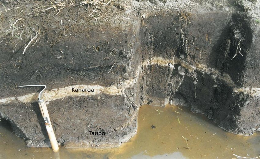
The thin white band in the centre of the photograph is ash deposited by the Kaharoa eruption exposed in peat at Waihī Beach, Bay of Plenty
This post is about the Tarawera Kaharoa eruption, and shows that it happened in June 1306. But it is a long story, connecting places as far apart as Taiwan, Ecuador and the Antarctic Peninsula. Enjoy!
Large volcanic eruptions throw out their ash and gas into the atmosphere and forget about the mess. They are heavy smokers who have never heard about such inventions as ash trays. (Mind you, most young people will not have come across those. We have at least cleaned up some aspects of our world!) One of our house rules is ‘You make a mess, you clean it’. It is applied within limits, of course. But volcanoes couldn’t care less.
The amount of ash that major eruptions deposit is outside of our experience. Etna left a layer of ash in local villages, requiring dump trucks to collect it and take it somewhere. Cumbra Vieja buried houses up to their chimneys. A decent eruption can cover many thousands of square kilometers in ash deep enough to kill the vegetation. Much later, people will find a distinct layer in the soil and wonder what had happened.
An important layer is found over much of the North Island of New Zealand. It is called the Kaharoa tephra. An example is shown below, taken from a peat bog at the Bay of Plenty. The layer here is about 5 cm thick, and is distinctly white compared to the black peat. Above the layer the peat is blacker than below. This is thought to come from burning, evidence not of volcanic activity but of human damage. Polynesians had reached New Zealand and had begun to make it their home. The evidence for their activities is only found above the white layer, not below. The data of their arrival is disputed, but this suggest they arrived around the time of this eruption. So, when was this ash deposited? And which volcano did it?
Let’s first take a step back in time. The colonization of New Zealand was just one part in an event that changed an ocean and created a world. It was the peopling of the Pacific.
Peopling the Pacific
The Pacific Ocean is an amazing place. The expanse of water is unimaginable, stretching halfway across the world. The continents that line it are worlds apart, with completely different people, history and culture. Australia’s and Papua New Guinea’s Aboriginees, the Han Chinese, the Chuki reindeer people, and the First People in America have nothing in common. The ocean that keeps them apart is occupied by different people again. They live on the volcanic islands that pepper the Pacific. Some of these islands are isolated to the extreme. Other islands form closely linked archipelagos. In either case, the people that live there are remarkably uniform in culture, in spite of living across an area larger than any continent. New Zealand’s Maori are part of that culture. The peopling of the Pacific is the ultimate story of adventure; and exploration of the unknown, knowing there could be no going back. When and how did it happen?

The shores of the Pacific ocean were first reached by humans more than 50,000 years ago. Impressively, that had already involved an ocean crossing of 70 kilometers into New Guinea. he abilities of people of that time went well beyond tools and cave paintings. The nearest Pacific islands of Melanesia, such as Bougainville, were also reached. But here they remained, on the rim of the Pacific. They only went to islands they could see. The horizon was their limit. The island hopping brought them to Australia, but the deep Pacific was beyond them.
The true expansion into the Pacific started in Taiwan, perhaps 5000 years ago. The people grew rice and millet, and kept pigs and dogs, and they took these with them. Evidence of their presence quickly appeared on the Philippines and Sulawesi. Rice did not grow well there, and it disappeared from their basket. Instead they adopted several tropical fruits. Chickens were added to the animals they kept.
Different groups now dispersed to different regions. One of these groups settled around the Bismarck Archipelago, off the northeastern coast of New Guinea. Here they developed a distinct style of pottery called Lapita. By 3000 years ago, this pottery appeared on Fiji, Tonga and Samoa, 5000 kilometers distant. And they traveled amazing distances. Guam was colonized by the Lapita culture, and that involved a continuous sea journey of 2000 kilometers. Was that an accident? Or did they know where they were going, and did they come prepared for long-distance migration? A trade network linked their islands: obsidian (a very valuable hard volcanic rock) from New Britain (part of the Bismarck archipelago, and a dangerously volcanic place) was found across much of the newly colonized world of Melanasia. The sudden expansion may have come from improvements in their canoes (perhaps the outriggers) but this is not known.
The Lapita culture suddenly disappeared from western Melanasia. It remained at Samoa and Tonga, but it lost the characteristic pottery. The trading network had collapsed. Some seafaring remained, and over time a new type of canoe was developed, which used a double hull rather than outriggers. And sometime between 1000 and 2000 years ago they began to expand eastward into the sparser islands of the southern central Pacific. The sudden resumption may have come from new technology (the double canoe) or just from the discovery of islands beyond the horizon. The amazing journeys now reached the Marquesas islands, Easter Island and even Hawai’i. They build their empire of volcanic islands by going against the direction of the prevailing wind. This may have been deliberate: by going against the wind, if anything went wrong they could quickly go back.
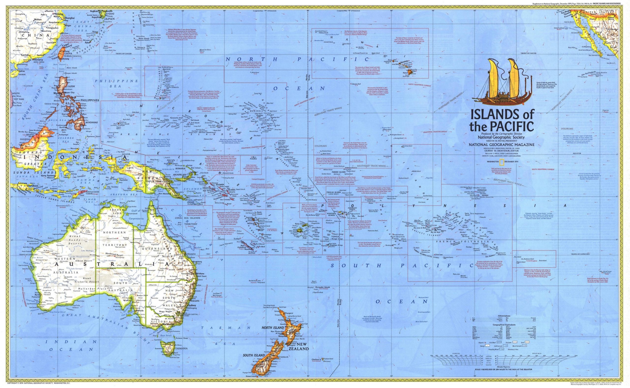
Map of the Pacific showing the islands and island groups of Polynesia. Click on the image for higher resolution
The sweet potato was added to the foods they grew. This was very unexpected, as this is a South American plant. The word they used for the sweet potato even has a South American origin. (It is however also possible that the sweet potato had spread naturally to the eastern Polynesian islands, before any human arrival.) Contact with South America is proven by genetic studies, which found American DNA in the genome of the eastern Polynesians, but not the other way around. That makes sense, given the size of the populations: genetic contact would have been highly diluted among the 100 times larger population of South America. There is uncertainty whether the Polynesians reached South America, or that the Americans came west and met them there. The contact appears to have been with people from the region of Colombia or Ecuador: both the human genetic tracers and that of the Pacific sweet potato point at this area. The human genetic signal is limited, and suggests that the mixing of populations happened only once. The fact that they acquired a new food suggests that the contact was not caused by a American canoe caught off guard by wind and currents and accidentally driven to Polynesia. It seems more likely that Polynesians traveled to South America, as they were the ones who had the ability and were already traveling that way. The arguments get heated and are driven more by opinions than by (sparse) facts. We do know that the early contact was with people from the Tuamotu islands and not (as often argued) with Easter Island. Traces of South American DNA is not found in Easter Island populations until 100 years later, well after Easter Island was colonized.
It has been argued that this Polynesian contact, around 1200, introduced their chickens to South America. Chickens came to South America with the Spanish. There is however some evidence for chicken bones in Chile which predate Columbus. This requires confirmation and the genetic evidence for non-European chickens is currently inconclusive. If confirmed, this would strongly point at an attempt by Polynesians to establish a settlement in South America. Such an attempt could also most easily explain both the genetic mixing and the acquisition of the sweet potato. If so, the settlement failed and like the Vikings in Newfoundland, the Polynesians left again. But if neither the chicken nor the sweet potato evidence holds, then we don’t know what happened! The only solid data we have is on the date, around 1200 AD,
But when did this expansion across the Pacific happen? Early carbon dating had indicated that the Polynesians spread during the first millennium AD, perhaps from around 500 AD. But more detailed studies done later found more recent dates, and this divided the scientists in an ‘early’ and a ‘late’ camp. Genetic studies added direction to the dates. The genetic diversity indicate that the expansion occurred in two distinct colonization waves. The first wave began in Samoa, and reached the Southern Cook Islands around 800AD. The second wave began around 1100 AD, and expanded from the Southern Cook Islands. Hawai’i was settled around 1200, apparently by two different groups.

From Ioannidis et al (2021). Click on image for full resolution
The genetic tracers that show mixing with a South American population are found in the area of the Tuomotu Islands, and in the islands settled from there, but not elsewhere. The date for the mixing agrees well with the Polynesian expansion, another indication that the contact was initiated by the Polynesians during their longest journeys. Interestingly, the islands with the American tracers are also the islands which have a tradition of stone monuments, such as the statues of Easter Island. It has been argued that this tradition also came from a South American influence.
The Polynesian expansion was not haphazard. They clearly knew where they were going. The Polynesians had recorded where the islands were, and had developed excellent navigation ability. They had explored and found the islands, returned to their homes to report and plan, and finally set out with a colonization cargo consisting of enough people to successfully settle, their crops and their animals. Even the Pacific rats which spread with the people may have been a deliberate cargo, providing another food source. They settled unoccupied locations. They left us no colonies in South America or Australia. They only went were none had gone before.
A long-distance trading network was again established, among the largest the world may have seen up to that point. Stone adzes, needed to make the canoes and which were made from basalt found in only a few islands, were traded around the entire region. This trade network was centred on the Southern Cook Islands. But over time it contracted and declined. The Marquesas dropped out of the network before 1400, and long distance trade may have ceased before 1500. In contrast, trade with nearby Samoa continued into the 1600’s. The reason for the decline in trade is not known. The 1453 eruption of Kuwae has been blamed but there is no evidence linking the two.
The incredible expansion happened during only a brief period lasting no more than 200 years. In this time the Polynesians colonized the Pacific, and discovered America before Columbus did. (They were not the first to do so, though. The people who lived there for 15,000 years or more (but are rarely credited with discovering America, and both the Inuit and the Vikings also got there before the Polynesians. Columbus came last in the discovery competition.)
For the Polynesians, finding a new Pacific island was the trip of a life time
The mammalization of New Zealand
The expansion across the Pacific took the Polynesians to the biggest prize of their empire, New Zealand. here they became the Maori. The Maori have stories about their history which tell that New Zealand had been discovered already by 800 AD, but the great fleet of canoes which brought the settlers only came after 1350. (The dates are based on counting generations.) The Polynesians knew where they were going. The original number of settlers may have been as large as 500 to a thousand. Genetic data suggests that the settlers came from more than one Polynesian island, either in a combined fleet or as separate arrivals over a century or more. The new settlers quickly spread out along the coast line.
Not everyone has agreed with these dates. Just like for the Polynesian expansion across the Pacific, there was a group advocating a ‘long’ history, where the settlement happened as early as 900 AD, and one arguing for a ‘short’ history with a settlement after 1200. The evidence for the long history came from carbon dating. However, these data have since been revised and the evidence now strongly suggests that the ‘short’ history is correct. However, a date of 1350 appears too late, for several reasons, including population growth models and the fact that Polynesia expansion had largely ended 200 years earlier. Currently, the first human arrivals to New Zealand are thought to have come between 1250 and 1325.
This migration took the Polynesians outside of their comfort zone. Polynesia is tropical, and New Zealand is not. Their tropical crops would not grow in New Zealand, with one exception: the recently acquired South American sweet potato. Without their gardens, they became hunter/gatherers. This was probably their common approach when settling in a new place, but the Pacific islands had limited resources for hunting which quickly ran out, necessitating a return to gardening for a living. New Zealand was much larger and could support hunters for many decades. But not forever. The new arrivals may have been excellent seafarers and navigators, they were not good conservationalists. It was too easy. The mammalian predators, both humans and rats, found New Zealand to be a walking buffet.
Top of the menu were the moas, flightless birds that had evolved to fill the ecological niche of grazers, and which had reached a size commensurate with that. They were as large as a small cow, and very edible. The Maori quickly established themselves as moa hunters. Their early settlements were on the coast, and shellfish and seal also became an important part of their diet. The coastal locations could be dangerous. A large tsunami in the second half of the 15th century wiped out part of the coast, and severely damaged many settlements. In places the tsunami had a run-up height of 30 meters.
New Zealand had been densely forested, and this made settlement of the interior difficult. The Maori began to burn down those forests. The hunting, the burning and the rats changed the land. All 11 species of Moas went extinct within 200 years of the arrival of humans. Even seals nearly went extinct. The hunter/gatherers now walked into a food crisis. In response, the population developed new, local crops, mainly suitable to the warmer climate of the North Island. They also moved in-land.
By the time the Europeans arrived, there were some 100,000 Maori living in New Zealand, but much of the land had become ecologically impoverished. It was a large scale change similar to what had happened on all Pacific islands, but it took much longer in New Zealand.
The Maori and the volcano
New Zealand has a unique way to date archaeology. This is a volcanic land where eruptions occur regularly. Small eruptions only have local effects, but large eruptions can leave traces across much the North Island. Over the time when the Maori lived in New Zealand, before the arrival of Europeans, there were six eruptions large enough to leave recognizable tephra layers in coastal regions where the Maori lived. The oldest of these is the Kaharoa Tephra, dated to around AD 1300. The second one is called the Loisels Pumice, a coastal pumice layer that arrived as a sea raft somewhere between AD 1305 and 1345. The third is the tephra from the Rangitoto Island eruption, which is only roughly dated to somewhere between AD 1410 and 1550. Finally, there are three tephra layers from Taranaki, namely the Newall Tephra, around 1600; the Burrell Tephra, around 1655, and the Tahurangi Tephra, around 1755. Of these six, the Kaharoa tephra and the Loisels pumice are most widespread, although the latter is only found at the coast.
The 230 AD Taupo tephra was the last major tephra layer before the Maori arrival. It covers 20,000 km2 on land with a thickness of more than 5 cm, to the east and north east of Taupo. A lot of the Taupo tephra ended up at sea: it can be found as a pumice layer on the beaches of both the North and the northern half of the South Island. Not surprisingly, there is no indication of any Maori activity below this layer. The Rangitoto island eruption did cover Maori settlements under its ash: New Zealand was clearly well settled by this time. The impact from the Rangitoto eruption did not spread far; even though the eruption was voluminous and lasted a long time, there was not much explosive activity apart from some water-magma interaction during its early phase. In consequence only the nearest islands were affected.
The Loisels pumice came from an underwater volcanic arc north of New Zealand. The precise origin of this eruption is not fully established: it is named after Healey volcano but it is not certain that this was the source. The pumice is rhyolitic, with a single chemical composition. Rhyolite is not so common from this area, and it makes an origin in a single volcano likely.
The Kaharoa tephra came from a large eruption at our old friend, Tarawera. The tephra covers 30,000 km2 on-land with a thickness of at least 3cm. The tephra is distributed along an arc extending both southeast and northwest from Tarawera. It extends along the coast of the Bay of Plenty to close to Auckland. Unlike Taupo, the eruption did not form significant sea pumice. The white tephra came from a series of separate explosions which can be recognized as separate layers.
The Kaharoa tephra has been dated using the remains of a tree (a celery pine) that was killed in a pyroclastic flow during the eruption. The tree rings were recognizable and gave a calendar date between 1302 and 1326 AD. The Loisels pumice has been much harder to date. There are some carbon-14 dates from shells, but these can give uncertain dates. This is because carbon can spend a long time in sea water before taking in by a shell. In contrast, carbon in the air is cycled through the soil quite rapidly. Seashells can therefore give much older dates (the age of the carbon rather than the shell). This needs to be corrected for, but this correction has a large uncertainty. The best calendar date is between 1280 and 1440. However, there are sand layers above the pumice which have been dated more accurately: these provide an upper age of around 1345 AD.

The carbonized tree remnant embedded in the Kaharoa tephra. This log was used to date the eruption. Source Lowe & Pittari 2014
The Kaharoa tephra and the Loisels pumice are not found in the same locations, so we don’t know which one is older. However, the Kaharoa tephra layer is thought to predate the Loisels pumice. Archaeology suggests that the Loisels pumice has buried younger deposits than the Kaharoa tephra. In that case, the Loisels pumice layer must date to later than 1300. The best dates are therefore between 1300 and 1345.
It is possible that not all Loisels pumice depositis have the same age. A distinction should be made between primary deposits, which is when the pumice first arrived, and reworked deposits, which is where an event (earthquake or storm) remobilized the pumice and redeposited it on the beach.
The best dates indicate that Kaharoa and the Loisels pumice came within decades of each other, after a quiet time which had lasted for a millennium. The Maori arrived at just the wrong time. First they found their coastal settlements under thick ash which killed all the vegetation, and not long after they found the sea and beaches made impassable by thick pumice, removing fish and shellfish from the diet. They suffered a double whammy.
Or did they? What does the archaeology say?
The oldest Maori settlements were found within a kilometer or so of the coast. The people left shell middens and moa bones, leaving little doubt about their main diet, although these may have been supplemented by gardens. A typical village supported some 100 people. Remains of such villages are found both above and below the Loisels pumice: when this pumice arrived, the coast was clearly already occupied. Both the layers above and below the Loisels pumice contain moa bones. Because moas became extinct within about 150 years of the Maori’s arrival at each location, and this indicates that the settlements had been less than a century old at the time of the arrival of the pumice.
The Kaharoa tephra shows a very different picture. It covers the Bay of Plenty, a very fertile region. But there is not a single Maori settlement found below the tephra layer, and very little indication for any Maori activity. Either the coast was very sparsely populated, or the Maori had not yet arrived here. The first indications of their presence comes from carbon deposition in peat, evidence of burning. This begins at the same time as the Kaharoa tephra. In a few locations the carbon is found below the tephra, but only just. The time difference is perhaps a few decades but less than 50 years. This puts the arrival of the Maori near or very shortly before the time of the Kaharoa eruption.
After the eruption, the area would not have been attractive to the settlers. The tephra would have killed much of the forest, and would have driven off the moa. For many years, the Bay of Plenty would have had little to offer. Later the area would have recovered, as the ash fertilized the soil and encouraged new growth. But that may have taken decades.
The arrival of the Maori is therefore closely linked to the Kaharoa eruption. This was the largest eruption in New Zealand since the arrival of the Maori. If the Maori arrived just after this eruption, they would have found the Bay of Plenty a desolate landscape, and gone further south. If they had already settled the area, the eruption would have given them very good reason to relocate. What do we know about this eruption, apart from the approximate date?
The Tarawera Kaharoa eruption
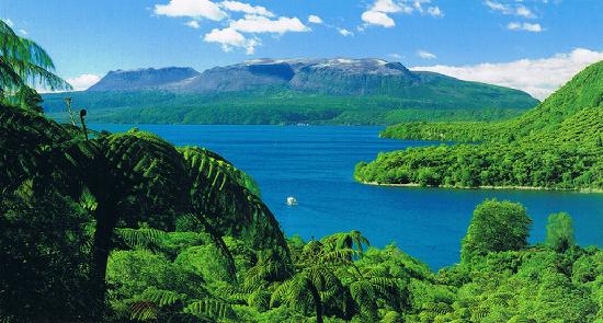
Tarawera, with Lake Tarawera in the foreground
The Kaharoa tephra came from Tarawera. The mountain is not particularly pretty (unlike the surrounding lakes) but deceptively dangerous. Taupo, to the south, is well known for the size of its eruptions. But Tarawera has history too. The overlapping calderas, each from a slightly different location, show that its behaviour is similar to nearby Taupo. The figure below compares the volume of the large eruptions from both regions. (The bars give the magma (or DRE) volumes: to get the VEI values, multiply by 2.5.) The Tarawera area (Okataina) never did anything as bad as the Taupo Oruanui eruption, 26,000 years ago, which reached VEI-8. But it has reached VEI-6 on many occasions, and managed at least one VEI-7.
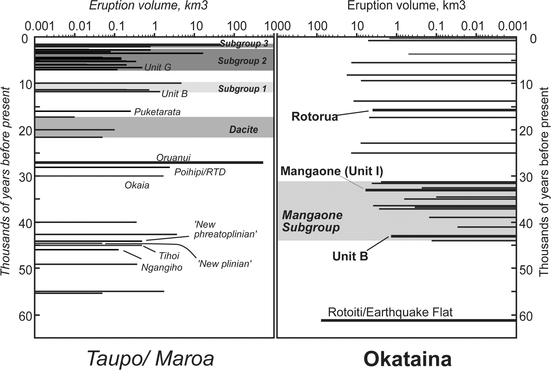
Magma eruption volumes for the Taupo and Okataina calderas, for the past 60,000 years. From Charlier & Wilson, 2010. Taupo is left, and Okataina (including Tarawera) is right.
Tarawera is mostly a rhyolitic volcano, albeit one where basaltic and rhyolitic magma can mix. The Kaharoa tephra is seen as a white, rhyolitic layer. On the slope of the mountain the tephra is 40 meters thick. Even 60 kilometers away it is still 10 cm thick, and it can be seen beyond 100 km distance.
The eruption that caused it occurred over many distinct phases. The tephra forms 13 separate layers from 11 explosive events, with the ash blown into different directions, mainly to the northwest and to the southeast. The eruptions were plinian to sub-plinian. As all Tarawera eruptions, it occured along different vents along a roughly northwest-southeast rift: for this eruption the rift was 8 kilometers long with at least four major vents. Each separate event may have lasted hours to days, based on the thickness of each tephra layer. There is no evidence for any erosion between the layers. Pyroclastic density currents and ashfall between the layers shows that there was a little time between some of the explosions, but this may only have been a few days. The explosive phase may have lasted in total as long as a month or two, or as little as two weeks. In either case, this was not a singular 4-hour event like the 1886 eruption.
The carbonized tree stump used for the dating showed a fully formed year ring below the bark, which indicates that it died during the New Zealand winter, between May and September. The burned trees are found at the bottom of the deposits, and it appears they were killed during a pyroclastic flow from the first of the explosions. The debris from the first set of explosions were blown to the southeast by a constant high-altitude wind. High-altitude winds in New Zealand are normally westerly, and southeasterly winds tend to be brief. This suggests that this winter eruption did not last long. The following layer (H in the alphabetical ordering of the layers) shows evidence for a changing wind during the eruption. The layers above that, which were ejected later, were blown into a north to northeasterly high-altitude wind. These wind directions are more common in early spring (September-October).
After the explosive phase ended, four large lava domes and one lava plug were formed. This will have taken much longer. A typical eruption rate for silicic lava eruptions is 5-10 m3/s, and at these rates the domes may have taken several years to form. These domes survive as the three peaks on the flat summit of Tarawera, and were split apart in the 1886 eruption. (The fourth dome was buried by the other ones, and revealed only by the 1886 rift.) The domes obliterated the craters formed by the earlier explosions. The explosions were probably the openings of the conduits that subsequently formed the domes.

From Lowe & Pittari 2014. The white deposit is the Kaharoa tephra, with clear layering. The dark layer above is the 1886 Rotomahana mud, and the yellow material below is the Taupo 230 AD eruption. The mountain in the background is Tarawera.
How large was the eruption? Studies have yielded surprising answers. The distribution of the tephra suggest that for the largest two or three of the explosions, part of the ejecta fell into the sea. Indeed, Kaharoa ejecta have been found in sea sediment. The thickness of the ejecta layers are measured at different distances from the volcano, and a function is fitted to determine how quickly it falls off with distance. That function gives the total volume for each layer, and includes the part that ended up at sea. There are many uncertainties. The thickness may have been measured at the most obvious places, which is where the layer is most clearly seen. But that may just be where it was a bit thicker, perhaps due to wind or movement by water. And different layers have different distributions, as the wind changed, perhaps even during the eruption.
The measurements indicated that the total erupted volume was around 5km3 DRE which included the lava domes and the tephra. (Note that ‘DRE’ stand for Dense Rock Equivalent, and is the volume of the crater that forms. The ejecta have a large volume because tephra has a low density.) This was a substantial eruption, where the explosions together were a high VEI-5, with a tephra volume not far below 10 km3.

From Sahetapy-Engel et al, 2014
A re-measurement in 2014 increased the number substantially. This study measured and fitted each layer separately, and derived volumes for each of them. The numbers are in the table. The authors calculated a DRE volume of over 7 km3 in the explosive ejecta only. Adding in the volume of the lava domes, the total became 9 km3 DRE. The explosive phase had a tephra volume of 15 km3! The means that the explosions together added up to a VEI-6. The individual explosion were of course smaller, with the largest ones producing between 2 and 3 km3 of tephra.

Source: Nairn et al. 2001
Where had all this material come from? Explosions this size should leave substantial craters. But in this case instead of a single VEI-6 there were 11 VEI 4 to 5’s spread out over an 8 kilometer rift. This makes the individual craters much smaller. They were later buried by the growing lava domes. Still, 9 km3 DRE even over an 8 km rift should leave a hole of 1 kilometer wide and 1 kilometer deep. But the mountain is only 1 kilometer tall. There may have been a series of older domes, blown apart by the explosions, but even so it remains hard to accommodate this much material. The older value of 5 km3 DRE is easier to understand. (In comparison, the Taupo eruption of around 230 AD produced about 30 km3 DRE.) The large proposed volume of the Kaharoa tephra requires confirmation.
In either case, this eruption was the largest one seen in New Zealand since the arrival of the Maori. It covered Tarawera’s slopes in 40 meters of lapilli, and devastated some of the best coastal land of New Zealand, within decades of the Maori arrival. It must have made the South Island, in spite of its colder climate, seem very attractive compared to the ruins of the North Island. Once burned, twice shy. Perhaps this is why for the first 200 years of the Maori presence, most of their settlements were on the South Island: New Zealand’s volcanoes are all on the North Island whilst the South Island is volcano-free – but it is, of course, earthquake-prone. In New Zealand you can’t win. Unless you are a rugby fan.
Perhaps the haka is really a Maori chalenge to the volcanoes of the north, in memory of Tarawera?
An ice core date
We can try to further narrow down the date for the Kaharoa eruption. An eruption this size should show up in the ice cores of Antarctica. Does it? Strangely, no one has looked. They should have.

The plot shows the monthly sulphate profile obtained from the ice cores. The blue line is for Antarctica (WDC06A, from Stigl et al.) and the red line is for Greenland. Tropical eruptions should show up in both ice cores, but eruptions in temperate regions tend to be only be seen in their own ice core. The tropics with its high troposphere forms an effective barrier to sulphate put in the stratosphere at high latitude. For a large eruption in New Zealand, the sulphate should show in Antarctica but not in Greenland.
There is only one sulphate peak within the allowed time period of the eruption, and it is seen in Antarctica only. The peak is not clearly seen in the annual data, where the sulphate in the ice core is averaged over each year. There is a peak but it is far from obvious and not certain. When I first looked at the ice cores, my detection algorithm rejected it. But here I am plotting the monthly data and this picks up the peak much better. It indicates that this eruption was a brief one, lasting only a fraction of a year. The sulphur declined within 1-2 months, and was gone completely after 5 months. The eruption had reached the stratosphere, otherwise it would have lasted no more than a few days. Over the next few months, the sulphur slowly came back down to the troposphere and rained (or snowed) out, and the ice signal ceased.
The peak occurred in the early (southern) winter of 1306. The sulphate began to increase in May or June 1306, peaked in July, and declined, with a second peak in September. This is consistent with what is known about the Tarawera eruption. As one interpretation, it could put the first set of explosions, when the wind was to the southeast, in May/June, and the second set, when the wind was northwest, in August/September. However, this may be optimistic as weather patterns also play a role in determining when the sulphate could have arrived in Antarctica. It is difficult to distinguish eruption patterns from weather patterns.
In any case, the ice core provides a solid date for the eruption. Tarawera exploded around June of 1306.
Burning ice
The ice core does not only show the volcano. It also shows the activities of the freshly arrived Maori. After their arrival, New Zealand suffered forest fires on a scale it never had before. The country is in principle not highly flammable, as it does not have the extreme weather patterns of Australia. Now, the trees went up in flames as the Maori saw them as surplus to requirements. The smoke reached into the sky, and was blown all the way to Antarctica. It too ended up in the ice.
The black soot from forest fires normally drops out of the atmosphere within a few days. In the southern hemisphere, much of it ends up in the oceans. However, some can reach Antarctica. The large annual fires of the subtropical regions of South America and Africa can dump a small amount of soot over the coast of Antarctica. Fires in Patagonia and New Zealand can also do that, but much more of their soot reached the Antarctic Peninsula, blown there in just a few days by the roaring westerlies of the Southern ocean.

From McConnell et al. 2021, Nature 598, 82
A recent paper looked at carbon in the ice cores from Antarctica. The data is shown in the plot, with black for the Antarctic peninsula (nAP) and red for the coast of Antarctica (DML). The time runs from 1AD to 2000 AD. The approximate time of the arrival of the Maori is indicated by the dashed line. The annual amount of soot at DML was relatively constant over that time. It is a little lower after 1500 AD, perhaps due to less burning in South America after the arrival of Europeans. That is an interesting problem in itself. The peninsula record, in contrast, is very different. It spiked around 500 AD and again around 1100-1200AD, followed by a large increase starting around 1300 AD. The early spikes are attributed to burning in Tasmania. The big increase and the higher level afterwards are from New Zealand. The Maori were clearing their new land.
The sharp sudden increase is consistent with the arrival of a significant human population. If only a few tens of Polynesians had colonized, the increase of burning would have been much slower. Instead they arrived in much larger numbers, in a planned settling of the new land. It was indeed a ‘great fleet’. And the onset of the fires can also be measured from the increase. It started in 1297+-30 AD.
The onset of the fires agrees well with the evidence from the Tarawera Kaharoa eruption. It doesn’t answer the question wether the Polynesians arrived before or after this eruption. However, an arrival a few decades before Kaharoa, perhaps around 1280 AD, fits perfectly well with the evidence from the carbon soot of Antarctica.
The ending
The story has brought us a long way, from the shores of Taiwan 5000 years ago and the shores of South America 900 years ago, to the arrival of humanity (and mammality) in New Zealand and finally to the shores of Antarctica. It gave us a precise date for the largest eruption in New Zealand during the presence of the Maori: May/June 1306 (you read it here first!). The Maori did not find an island paradise. During their first decades in the new land they suffered not just one major eruption, but two, when the destructive Kaharoa eruption was followed by the Loisels pumice. The Bay of Plenty would have looked very different and distinctly uninviting during those years. But the Maori too played their part. Just as the volcano spread its ash across the land and beyond to Antarctica, so the Maori spread their soot equally wide. Neither volcanoes nor people cleaned up the mess they made.
New Zealand has changed forever. New Zealand was the last major land mass ruled by the birds. I regret not being able to see the moa, or the gigantic eagles which hunted them. These birds had created a land akin to the world of the dinosaurs, which we have lost. The past is in the past, and people needed to live. But New Zealand is not just shaped by humanity. Volcanoes too have played their part, and their legacy can be seen in many places. The soil of New Zealand is the ashtray of the country, which still contains the ash of volcanoes past. That 700-year-old white band in the black soil tells us a story from a forgotten time, when people traveled halfway across the globe into the unknown, to go where none had gone before, to explore new worlds and to build new civilizations. We have seen nothing like it since. Tarawera is forever part of that adventure.
Albert, December 2021
What could have been
References
Peopling of the Pacific: A Holistic Anthropological Perspective. Patrick V. Kirch, Annu. Rev. Anthropol. 2010. 39:131–48
Paths and timings of the peopling of Polynesia inferred from genomic networks. Alexander G. Ioannidis et al, Nature 59, 522–526 (2021)
Hemispheric black carbon increase after the 13th-century Māori arrival in New Zealand. Joseph R. McConnell et al. Nature 598, 82–85 (2021)
Deposition and generation of multiple widespread fall units from the c. AD 1314 Kaharoa rhyolitic eruption, Tarawera, New Zealand. Steve Sahetapy-Engel et al., Bull Volcanol 76, 836 (2014)
An ashy septingentenarian: the Kaharoa tephra turns 700. David J. Lowe and Adrian Pittari, Geoscience Society of New Zealand Newsletter 11, 1-13 (2014)
Distribution, stratigraphy, and history of proximal deposits from the c. AD 1305 Kaharoa eruptive episode at Tarawera Volcano, New Zealand. Iain Nairn e al., New Zealand Journal of Geology and Geophysics, 44, 467-484 (2001)
Chronology and Evolution of Caldera-forming and Post-caldera Magma Systems at Okataina Volcano, New Zealand from Zircon U–Th Model-age Spectra. B. Charlier & C. Wilson, Journal of Petrology, Volume 51, Pages 1121–1141 (2010)
A post on Taranaki, the most frequent New Zealand eruptor during Maori times, can be found at https://volcanohotspot.wordpress.com/2021/11/15/mount-taranaki-new-zealand/


Albert
the picture above the paragraph that starts with Mammalization is extremely beautiful.
The island is Bora Bora
I’d really like to see it. And this (Moorea):
What a cone.
Next time you are in Australia (New South Wales to be precise), try to see the Warrumbungles. The feature called the breadknife is like this, but much thinner. Very impressive. I haven’t seen that park since the big fires, so not sure what it looks like now, but it used to be a marvellous place for walking.
Thank you very much for the tip. I must admit that I’ve never been to Australia. First we took the children around Germany, then France, Spain, the Netherlands, Denmark, Austria and Switzerland. So we all know Europe extremely well and got attached to some places, some of America as well.
But they are ready now, once they earn some money to go elsewhere. They will take me along (Dad late unfortunately).
I know many place from books, also Geology books and talking to tourists from those countries. That works out better than I thought.
We once wanted to do Bora Bora, Moorea, Tahiti, New Zealand and Australia with a cruise, there was a perfect cruise for us, but too expensive. I learnt to admire the whole world from far away.
In your home country I got attached to Waterland, in England to the Dartmoor and the Dorset coast, in Switzerland most to Lac Léman (Geneva).
Forgot Italy, but that`s like home.
Greetings from ego shooter Crysis (1)^^
What a game 😮 , and what a gorgeous setting!!!
Don’t know that. Know Unchartered quite well. Was often lying on the couch while my son was playing it, because I loved the graphics. After a while I fell asleep with Drake’s voice in the background. It’s a shooter, but some in it is peaceful enough to fall asleep, maybe the landscape.
Sometimes we looked up the places and the stories behind.
I think it was a master work, all four.
Corr: Uncharted.
Was 2007 years. That was some times I tell you!
It was when they used to leverage that very shooter for a benchmark. It was better than all graphics cards could handle at that time. Was due to the extreme details of a beautiful tropical setting somewhere in the Pacific. I think real setting was Tahiti, and the distinct mountain at the far horizon in the game was called Moorea, in real.
In the game though it was called Ling Shan islands.
Unfortunately the warm beautiful landscape had a dark secret. It was infested with ice shooting aliens, especially to the end 😮 .
So warm in the beginning but no warm end, as the aliens managed to cool down a large area to about 73 K. Cooler than liquid nitrogen then =/
Involcan, La palma, Images from the Cabeza de Vaca track at 7:00 pm Canarian time of one of the eruptive vents
https://twitter.com/involcan/status/1466848048240377870
-31.16m
http://brunnur.vedur.is/gps/grimsvotn.html
Thats 3 atmospheres removed from the shallow magma chamber.
Here is How inflated Grimsvötn is now
https://mobile.twitter.com/LavaCentre/status/1466790932095897600?fbclid=IwAR2SSOt0SKaCs47eWabeu7PTYD_F-r4OSb8UquXQy6K3YDSKcEWA1ltmgsk
-32.15m…
And tremor rising…

Don’t hold your breath. 😈
Jon is absolutely right taking pressure off in those tweet comments.
There is nothing happening in Grimsvötn yet except the emptying of a full lake.
First signs of G’s activity, ramping up to…, where are they?
Heating up a glacier is one thing, erupting is another!
You forget to mention the big inflation that Grimsvotn already have and glacier falled already -40m!
The flood already started and is expected to peak tomorrow or next days…
And like Dr Gudmundsson told, they expect the eruption start by then.
The chamber is highly pressurized now, do you think a big lake drainout coud remove enough pressure to start the magmatic gas nucleation process?
Had this happened one year aftet 2011, there woud not be any eruption at all, since the chamber is not pressurized at that moment
If you watch the instruments on Hawaii, be aware big storm coming. From DailyMail.
“Storms coming to Hawaii this weekend could cause blizzard conditions on the summits of the big island with winds at over 100mph.
The warning from the National Weather Service is in effect from 6pm Friday to 6am Sunday.
More than 12 inches of snow could be coming to the mountainous regions on the big island.
The blizzard-like conditions are part of what’s known as a ‘Kona’ storm. Those are a type of seasonal cyclone on Hawaii, usually formed in the winter from winds coming from the westerly ‘Kona’ direction. Kona lows often bring about wet and ‘unsettled’ weather.”
Sleeping with Lions in reference to some posts above. First night of canoeing and camping on the Zambezi in Zimbabwe, we organised our sleeping stretchers above which we draped a ‘mosquito net.’ Mine had large holes, so I made an enquiry about the size of the mosquitoes thereabouts. There were no mosquitoes, but erected as a defence against lions. If they cannot see your head, they will not attack was the expert advice. I remained extremely sceptical as distant roaring appeared to be edging closer and closer. The expert himself slept in the open with his head under a foldable chair.
Funny report. Maybe they roamed through your camp at night while you were sleeping and seeing no heads 😉 took off. Possible. You are not supposed to look straight at a bull terrier. Animals.
Was nobody afraid of Black Mamba sneeking in? That’s what would give me the creeps.
There was a reference to this in Elspeth Huxley’s book (think it was hers. ) The guide informed that one of his clients, exhausted from all that canoeing, was unaware that his arm was outside the netting. A hyena trying to drag it out further, quickly alerted him to the fact. The most dangerous animal for canoeist/campers is the hippo.
Kilauea tiltmeter is showing another DI event, but ever since the eruption began the DI scale has been tiny, 2 microradians total often even less. Yet even at this tiny scale the effect on the eruption is quite clear, the lake nearly totally stagnates on the surface. The GPS also shows little vertical variation, no inflation, which shows the magma chamber is not pressurizing. Looks like Kilauea has got an open conduit again 🙂
There are now some quakes appearing at Grimsvotn in the last few hours 🙂
Probaly related with the draining of the subglacial lake, nothing magmatic
GVP on SI shows basalt/picro-basalt.
Will this be runny as FAF?
And will it be long as FAF? And what about flow rates in the first place?
What is SI?
Smithsonian Institution
What volcano haves picrite now?
Piton?
Was talking of our possibly next eruption that is well discussed on VC, that is “Mister G”, or “Grimmy” like it was called here.
Grimsvötn does mostly homogenius Thoelitic Basalts, the 1998 – 2004 caldera basalts are sligthly evolved, But became very primitive at 2011 with a sillicate content of 49% and high olivine content in the glass chemistry, Laki 1783 is similar to the 2011 eruption in compositon, very similar to Hawaiian Basalt
Thank you for the confirmation.
So this will be also hot lava, maybe 1200 °C?
Depends on how fresh it is next time, it may get up to 1160 C as there is some cooling in Grimsvötns shallow chamber. The 1998 – 2011 eruptions been quite cool .. with hotter stuff emerging in 2011. Next time it will be even hotter, perhaps 1150 to 1160 C. Grimsvötns supply is high enough activity frequent enough that you never gets really evolved melts at the caldera.
But it will not be as primitive as fagradalshraun
Meanwhile (08:39 UTC) they have altered the camera settings in such a way that the volcano is looking like it was on Iceland:
The sulfur deposits resemble that green Icelandic moss, both the clouds and the steam have a very blue color due to the many glaciers laying around it and the lighting is very dim due to the low sun close to the arctic circle. 🙂
Because of both climate breakdown and earth heat, unfortunately there is no snow visible. :/
Indonesia eruption
https://www.bbc.co.uk/news/world-asia-59532251
Wow What a magnificent pyroclastic flow! As dangerous as its beautyful
I guess the Chicxlulub blast ground sourge must have dwarfed that
Volcanoes seem to be reading and listening. They are all talking about Grimsvötn and Taal, Semeru complains to his numerous neighbours. I’ll show them!
I believe that this is a mistake (one of the many): “It is located in the subduction zone, where the Indo-Australia plate subducts under the Eurasia plate.” Semeru, wikip.
Same source: The Sunda Plate is the pinkish-purplish area:
Nice area for you, Albert 🙂
At least 1 dead, 10 wounded according to reports: https://www.kompas.tv/article/238672/update-erupsi-gunung-semeru-lumajang-mati-listrik-1-orang-meninggal-dan-10-luka-luka.
Also power outages and a bridge linking Malang and Lumajang collapsed because of mudflows. https://twitter.com/anthraxxx781/status/1467116958143242241
This eruption clearly caught people by surprise.
Might not have been much warning:
Semeru was on alert level II (Waspada).
“He added that a bridge connecting Lumajang with the nearby city of Malang had been destroyed by the combined effects of the eruption, a thunderstorm and heavy rains.”
Pic further down.
https://www.independent.co.uk/asia/southeast-asia/mount-semeru-eruption-volcano-indonesia-b1969765.html
Thank you Albert. The story of the loss of the forests and birds is a useful corrective to the “stewards of the land living sustainably” mythos so often applied to indigenous peoples – not that they are much more indigenous than the first European settlers of the Americas (see also the enslavement and extinction of the Chatham Islanders at Maori hands).
Still, my own country killed off all its wolves and beavers – and we are only just discovering the importance of the bogs the latter created, as carbon sinks and for flood mitigation.
Presumably the Maori could have domesticated the moa had they thought to do so?
(The whole question of contact between the Americas and Polynesia is a fascinating one. The Polynesians were amazing ocean sailers, surely the best in history before the Portuguese got going with Vasco da Gama – and he started out by following coastlines – no such options in Polynesia.)
Only to go to Madagascar 🙂
Are you American? I’ve read many times that the North American Indians indeed knew how to hunt sustainably and not take all the forests down.
Probably trial and error, places settled millennia ago probably have since learned to live sustainably, more recent times of discovery and the lesson is newer, and today it seems we are soon to have to make the discovery again.
It is pretty much undeniable in most places the arrival of our species saw decline in megafauna. Only exception possibly was Australia, which had millennia of coexistence, the native megafauna lost diversity but probably was able to survive until the early Holocene. There is a Dreamtime story of an animal called the Dirawong that is thought to refer to Varanus Priscus, or megalania as it might be better known. Supposedly it was a fairly docile creature whos extinction was at the hands of dingos, which only reached the continent in the Holocene (also rather defies the bloodthirsty reptile superpredator reputation megalania has), suggesting the 5 meter reptile was around a lot longer than you will read on Wikipedia. Just one example, it is truly a great loss that most of the culture and legacy of that story has been lost, it is a window into a world everywhere else forgot. Really the fossil record of late Pleistocene Australia is terrible, many of the megafauna could have survived much later than the official extinction date.
Probably it was the transition to a warmer climate that saw species decline that were adapted to cold, and our presence was enough to push beyond the point of no return, we had not left Africa in the prior interglacial. In the Americas it seems to have been more direct, as soon as the Holocene began everything except bison and jaguars went extinct among the continents megafauna.
No society (except perhaps tibet under the dalai lama) have ever tried to live sustainably and until now nobody knew what it meant. There isn’t even a rational definition that is universally accepted and I know of none that exist today in general usage other than ‘wilding’, but that is by definition very unproductive for human survival.
Some impoverished hunter gatherer societies live sustainably but that is forced on them by their environment. Children get born every few years but by definition all bar two per mother die before breeding.
“Native Americans, Alaska Natives, and other Indigenous peoples have a long tradition of living sustainably with the natural world by understanding the importance of preserving natural resources and respecting the interdependence of all living things.”
https://www.narf.org/about-us/environmental-sustainability/
I agree. 😉 It’s publicity.
“When white European settlers came to America they saw a land rich in natural resources. They looked at the land and saw many things that could be harvested and sent back to Europe to sell. Trees, wildlife skins, tobacco were all in great demand across the ocean. ….
While many different Native American cultures lived in very different geographic areas in what would become the USA, they had a common collective wisdom. They recognized and understood that all parts of an ecosystem are connected. That humans, animals, plants, and even rocks, were dependent upon each other for survival and the well being of the ecological niche they lived in. …..
Everything that we do as humans effects the environment in some shape or form. This fundamental belief put the Native American human on equal footing with the animal they hunted for food or the berries they took from the bush.
They understood their lives made an impact. And because of this knowledge, they treated nature with a level of respect and admiration that is often dismissed in modern cultures.”
https://www.foxrunenvironmentaleducationcenter.org/ecopsychology/2020/6/8/what-native-americans-teach-us-about-sustainability
This is the narrative. And it’s old. The Europeans gave testimony of it.
There are 2500 years between the Polynesians and the testimony about the First People of North America. That’s a long time. It might be true in this case. It might be the exception to the rule.
– Indians walk softly and hurt the landscape hardly more than
birds or squirrels.
– John Muir
North american indians drove herds of bison off cliffs and harvested only a bit.
What forced them to be ‘sustainable’ was the inability to do anything else.
With guns and horses they would have eradicated the bison too.
In european 20C farming farmers did/do farm sustainably, buying in the nutrients they sell, only the fastidiousness of the urban population prevents better recycling of nutrients, never has bothered farmers.
‘Organic’ farming only works if you recycle the nutrients and grow all your own food. Export food but do not recycle sewage and you can never be sustainable.
The were hunter-gatherers, that’s why they were probably able to do the assumed passage from Sib. to Alaska some 12000 years before.
That has nothing to do with agriculture. The cliff story is not really believable. They had spears and arrows, no guns, before the Europeans came.
More in response to Denali Watch, it depends on the tribe, some were farmers, in fact many tribes were farmers. The Pueblo are farmers, mound-building cultures in the midwest were farmers and had cities. The US constitution is partially based on the Iroquois governmental system, and they were farmers. Mayans, Olmec et were definitely farmers. What they didn’t have is metal.
West coast has more hunter gatherer tribes but also more rugged terrain, and maybe more animals to eat. Also there was some aquaculture going on.
To Canthisbenull:
Thank you.
Same source:
“Today Native Americans, Whites, and other Americans from diverse cultural heritages are working to bring back traditional earth management systems. When we see ourselves as one with the system we tend to be more respectful in how we treat the planet. A popular political answer is to blame others – other politicians, other countries, the guy down the street…
This attitude puzzles me and others of Native American heritage. Blame gets us nowhere. We all must step up to the plate and work together as a team to conquer the blame game and to learn to live with nature.”
ame vanorio, June 22, 2020
The myth of the “Noble Savage.”
Yet another amazing piece of yours, Albert!
This must have been quite some effort by you, thanks once more!
I really love those comprehensive and well-written posts, were it all comes together, archeology, geology, history, common sense <3
Yes. He’s a true scientist looking at the other disciplines. And this way it’s extraordinarily interesting. Carl found him, he said in the VC birthday piece. So, cheers to Carl too.
One early scientist was Leonardo da Vinci. He just looked at everything. In Venice there is a permanent exhibition of the flying objects he built.
La palma, drone flyby 8:20, some lava flows.
Thermal camera, drone flyby
Involcan, Moment in which the new south lava flow crossed the El Hoyo Todoque road at 1:15 pm Canarian time
https://twitter.com/involcan/status/1467142891608936450
Ayuntamiento de El Paso – CRISIS VOLCÁNICA – VOLCÁN DE LA PALMA
La palma, Detail of the new emission point generated today to the Southwest of the volcano at a lower level. Unknown video author.
https://www.facebook.com/VolcanesCanarias/videos/693168911570823
The aprox, position, at 15:00 local. Has moving on directions to cross the LP 213 and Las Norias.

https://twitter.com/icelandgeology/status/1467186453868384258
Sharp change in harmonic tremor in Grímsfjall volcano. Situation is unclear. Nothing has been confirmed.
That was rather unexpected. Wonder if it will start up again, then again I think it would probably break through further north than we’ve seen.
It will probably remain in the general area, but La Palma eruptions in their late phase do tend to wander around and open new vents, sometimes after the eruption has seemingly ended
Hekla: A British-Icelandic friend has just emailed me saying “Now Hekla ramping up! Streams have dried up suddenly, according to Mbl article and this behaviour preceded the 1947 eruption.”
I think this is the article she is referring to, from yesterday evening.
https://www-mbl-is.translate.goog/frettir/innlent/2021/12/03/vatnsthurrd_eins_og_thegar_hekla_gaus_1947/?_x_tr_sl=is&_x_tr_tl=en&_x_tr_hl=en&_x_tr_pto=sc
Earlier was reported that there was inflation over a 30 km area, which could be Hekla or Vatnafjoll, or both, that is a quite sure indicator of more than nothing being likely in the near term. Now still persistent quakes at Vatnafjoll… I would assume an eruption there will be noisy but maybe still sudden, couple of days of intense quakes then a few more days of lava flooding, followed maybe by cone building like seen on La Palma. Hekla will probably do what it has done the last 50 years but a bit bigger. I dont think Hekla will go without warning, it is better monitored now, but probably still around an hour before. But definitely we will see it do something before it erupts, like we saw at Kilauea in September, something looking different.
I am going to also make the prediction that none of the eruptions expected will coincide exactly, they will miss by a day or so, just to annoy us all… I dont think two volcanoes in Iceland have been erupting at the exact same time since the middle ages actually, same year but not simultaneous.
The reporting is a bit puzzling.
As you say, the diameter of the uplifted area is given as 30 kms (presumably centred on Hekla), yet the article seems to deny that the Vatnafjoll activity is linked to Hekla, though the epicentre less than 15 kms from the summit of Hekla as the crow lies. And I find it hard to believe that an M5.2 would not have any effects on the Hekla system, even if its origin was tectonic.
Interesting that Páll Einarsson, who correctly warned of the 2010 eruption, 30 minutes in advance, does not seem to be expecting a future eruption to be more predictable.
Wow!
https://twitter.com/involcan/status/1467212069158150146
New fissure west of the Las Manchas cemetery at 6.30 pm Canarian time
https://twitter.com/involcan/status/1467214533831929865
What would the VEI be of that Semeru eruption? VEI 4?
I doubt it, VEI 3 is more likely in my opinion.
Might not be explosive at all technically, collapse of lava flows to create a pyroclastic flow and plume from that. Semeru has been erupting effusive since last year pretty much non stop, just slow, lava piles up near the summit, and I guess now it all slid down. Same thing happens every time Fuego erupts, it isnt really explosive but the extreme steepness of the cone makes the lava flow disintegrate and turn into a fluidised powder/gravel, which is what a pyroclastic flow is.
Is really just a reality of a steep pyrocalstic cone like this, unless the lava is at olive oil viscosity like Nyiragongo pyroclastic flows are probably a common occurence. I have even seen some flows on Hawaii that became pretty avalanche-like going down the pali, it is just that but faster.
So this eruption is basically a VEI 0-1 that has cheated a bit…
Clearly not a sustainable volcano. Doesn’t know the word “reuse”.
Opens up a new vent for each small inflation that it’s suffering.
(Referring to the volcano born on 9/19, as most of my comments are unless declared otherwise)
What could make the GRF tremor rise like that if not a preparation for eruption?
(And why would the tremor rise in such a linear fashion like it did the last days?)
Btw, are we supposed to see a lot of quakes before it really starts?
Kristin Jonsdottir from IMO tweeted on 3 Dec ‘seismometers show flood tremor”.
The purple line (0.5-1.0hz) started rising today too. That’s new.
(I’m sitting here grinning with excitement for a potential eruption soon – one that hopefully looks really cool but causes no damage to anyone)
link to tweet here
https://twitter.com/krjonsdottir/status/1466707646090723329?s=20
How much have the lake dropped now? I doubt there will be any eruption either in Grimsvötn, it can easly go 20 years without eruptions
But perhaps not now, with era of higher supply
If I’ve read this correctly, it’s dropped by 70m. (Correction welcomed.)
https://www.ruv.is/frett/2021/12/05/ishellan-hefur-sigid-um-70-metra
To Chad and Farmeroz, text further up in the discussion about natives:
The First Thanksgiving, a painting by American painter Jean Louis Gerome Ferris.
Clovis theory:
https://en.wikipedia.org/wiki/Clovis_culture
And a second hypothesis:
https://en.wikipedia.org/wiki/Solutrean_hypothesis
This with an Atlantic route to the Great Banks. Older migration. Possible. The Vikings did it as well.
This one is unlikely to the extreme. There is no evidence, no problem that it solves, and it poses that they crossed the Atlantic ocean in the middle of an ice age in open boats. Read Shackleton to see how impossible this is.
Agreed. The Clovis Theory makes sense though. There are four theories for the Younger Dryas, none with conclusive evidence. I imagine a volcano in Kamtschatka/Kurils. Or Fuji? (Wikip., Mount Fuji, geology.)
“The modern, “New Fuji” is believed to have formed over the top of Old Fuji around 10,000 years ago.”
They took some the reindeer with them, I guess.
“”In spite of the great variation, all the Pleistocene and living reindeer belong to the same species.” wikip. and ITIS list Wilson and Geist.
“Around” is the decisive word here for Fuji.
It’s probably Clovis. Why would they take off? Younger Dryas, looking for food.
Why would they “take off”? Because they could, always greener over the horizon.
There is no reason to think that clovis, or their predecessors were significantly less advanced than 14C Inuit, both stone age but well able to travel coastal routes with much ice and nothing but hunting to support them. So to me the coastal route is just obvious, why cross barren intercontinental areas when you have a coastal strip brimming with life to hunt. The former is stupid and the latter inevitable.
The evidence is now sadly underwater.
In reality its (from memory) I think recorded the locals fed the immigrants, who were starving.
Your memory goes back a long way ..
The tribe that befriended the immigrants wasn’t doing too well at the time, either.
It was kind of a collaboration because both groups were in danger, one by starvation and the other by rival tribes.
I tried in vain to find the article I read, thought it was in the NYT, a few weeks ago.
Though this is an interesting article:
https://historyofmassachusetts.org/native-american-tribes/
La Palma earthquake at only 3km depth.
2.1 mbLg
S EL PASO.ILP
2021/12/04 20:57:26
3
https://www.theguardian.com/world/2021/dec/04/indonesia-one-dead-as-semeru-volcano-spews-huge-ash-cloud One person has died after the highest volcano on Indonesia’s most densely populated island of Java spewed thick columns of ash high into the sky, triggering panic among people living nearby.
As well as the fatality, the volcanic eruption of Mount Semeru in East Java province caused 41 burn injuries, said the deputy district chief of Lumajang, an area nearby.
Mount Semeru’s sudden eruption on Saturday left several villages around its slopes blanketed with falling ash.
The eruption was accompanied by a thunderstorm, which pushed lava and smouldering debris and formed thick mud that destroyed at least one bridge connecting two main villages of Pronojiwo and Candipuro, as well as hampering the evacuation, the Lumajang district head, Thoriqul Haq, told TVOne.
“Thick columns of ash have turned several villages to darkness,” Haq said, adding that several hundred people were moved to temporary shelters or left for other safe areas.
GeologyHub video about Semeru. Ash to 15 km and pyroclastic flows to 7 km.
Glacier flood from Grimsvotn
https://twitter.com/krjonsdottir/status/1467269478975164422
How much have the lake sunken now?
The graphic stoped some hours ago on -50.82m
55m. Looks like the discharge from the lake has peaked at around 3000 m3/s and is starting to slow down.
http://husbondi.rhi.hi.is/gvth/drainage.html
It’s -69.23m now
http://brunnur.vedur.is/gps/grimsvotn.html
Big up on Grimsfjal tremor plot!

La palma, image of the new lava vent, Has move to the west….
Wondering if there is a line of weakness that way, a shallow dike perhaps. I will have to find the new fissure location on google earth but it looks like it could align with the other one that formed that direction a little while back. 1712 eruption has a line of effusive vents going a long way down the mountain from the main cone.
If this is the case the cone might be functionally dead, with new flows coming from this fissure, flooding the area with fluid lava.
I start to think that has be la palma has convert on mayor eruption and go to pass chrismast and carnival.
I continue compare them with the 1704-1705 eruption on Tenerife, a complete fisure from near 13 km on the North East dorsal. With 3 eruptions and 87 eruption days (I live here, over Arafo / las arenas volcano). I have very worried with them.
I think it is already bigger than any other historical eruption in the Canaries, except for Lanzarote, although that could be considered multiple eruptions in a single sequence.
I dont think this is at deaths door, if one looks at 1949 there was a stage of cone formation, then lateral fissure, then collapse pits above the conduit as lava drains, and finally a last phase of brief high intensity effusion. By analogy, we might actually only just be getting to the second phase, which could last longer than the first and potentially be more destructive. If this is the case more effusive vebts will probably open south of the cone and parts of the cone could collapse, and possibly also become much more vulcanian in character.
Currently the eruption is over 0.3 km3. I would not expect it, but a volume approaching 1 km3 and duration of 6 months-1 year is not at all improbable. It is also not impossible this drags out for multiple years, possibly with more cones opening, as at Lanzarote.
Looks like there was a big one today at Semeru in Indonesia. Ash cloud to 50000 ft plus and lahars that took out highways. https://watchers.news/2021/12/04/semeru-volcano-eruption-indonesia-december-2021/
chad
How was Grimsvötn born, and how did it look like before the caldera complex got there?
Was it born like a little fagradalshraun or born through a bigger show? Grimsvotn is not Kilauea or Mauna Loa, But its pretty huge anyway as a volcanic system.
How did that thing began? I read that Grimsvotn is tought to be around 110 000 years old so a pretty young volcano, Bardarbunga is older, Grimsvötn haves controll over more spreading
Depends, the system is probably older, but Grimsvotn itself is maybe pretty young. it really all depends on if the volcano is defined as the whole fissure swarm or just the visible central volcanoes, and a lot of that depends on if eruptions on the fissure swarm are eccentric or lateral, which is not entirely settled. I think it is a combination of both, big rifting events probably see magma flow both horizontally and vertically, and direct from the mantle doesnt actually mean the magma was in the mantle recently just that its composition has not changed.
Thordarhyna is maybe the original central volcano on the swarm, and Grimsvotn is a younger sibling, is what I think anyway.
https://imgur.com/a/Y5ud8Af
Might be hard to see but this is where the new vent is, it is actually way downslope of the cone, almost half way to the ocean. It also looks to be at least close enough to the older vent from last week that the two are probably related.
Having the shallow dike keep propagating also would explain why the eruption stopped at the cone, and also at the first flank fissure, lava was still draining further down.
But in the video an existing colada is passing at the suspected vent.
Couldn’t this just be a catastrophic failure of a hidden hose in that existing (older) colada visible in the picture’s background?
It really just passes by the vent…
If that would really be a new vent it would pose next level of danger from this volcano….where they could start asking themselves “Who tells me that one won’t open right below my house??”. 😮
No it is definitely a new vent, you can see the fissure in the ground on the new videos of it. The older flows were the ones that came from the vent on November 26, which is from the fissure that is closer to the main vents.
The death toll rises to 13 due to volcano eruption in Indonesia
The death toll from Indonesia’s Semeru volcano eruption has risen from one to 13, the disaster management agency said today, as first responders continue to search the area.
At least 57 people were injured in the eruption, 41 of whom suffered burns, the disaster management agency said in a statement.
https://www.sapo.pt/noticias/atualidade/sobe-para-13-o-numero-de-mortos-devido-a_61ac48ec2111ff2e05d1c53c
Ice sheet in Grímsvötn already subsided 70.78m
http://brunnur.vedur.is/gps/grimsvotn.html
New article is up about how bad would a Katla eruption be?
https://www.volcanocafe.org/what-if-katla-erupted/
To Albert
I looked this island up because of a 6.5 earthquake west of it today. Found this:
“Hasselborough noted at the time the presence of a wrecked ship “of ancient design,” presumably Polynesian.”
https://www.britannica.com/place/Macquarie-Island
They went far south then. They knew Antarctica.
No, that is not correct. The Maori went as far as Auckland islands, well south of New Zealand, but Macquarie island is twice as far and beyond their reach. The story you refer to never mentions Polynesia. It stated the ship to be large and of ancient design. The rest of the quote you give is an addition. Hasselborough thought (wrongly) it was Perouse’s ship. He apparently mentions large beams, which would indicted a western ship. Selkirk in 1990 (Subantarctic Macquarie Island) writes the following
Wow Auckland islands is at Latitude 51 South, same as London, but the climate is cooled by the Antartica Icesheet and lack of landmasses, they are colder than the Faroe Islands. Must been a shock for a pepole thats used to subtropical and their ancestral tropical conditions. But the cold seas There are much richer than the marine desert that is the tropical pacific
They weren’t tropical Polynesians, they were Maori from the South Island, so used to winter. They went to the Aucklands probably to hunt seals, but didn’t settle there. I think
South Island still haves a very mild coastal climate .. near Subtropical and Palm trees grow there too
But not warm in winter
South Island haves a similar climate to the very warmest parts of South UK
Wondering that you do not say anything about the special rocks of that island. It is probably one of the few UNESCO-sites without tourism.
Well, thank you. Then Britannica has it wrong.
Could it be that it was a self-built ship, possibly with some help of locals from Vanikoro?
“that some of the men were killed by the local inhabitants, while the surviving sailors built a smaller vessel and left the island, but were never seen again. Those that remained on the island died before search parties arrived in 1826.”
https://en.wikipedia.org/wiki/Vanikoro
t would explain that the ship was strange.
There is no reasonable route that would have taken from there to Macquarie. They would have gone to the nearest coast
Well, thank you. Then Britannica has it wrong.
I remembered something I read a long time ago (after the 2004 Sumatra tsunami), that southern New Zealand was “set on fire” by an impact in the ocean.
This is yet to be proven, but it is related to this thread.
https://www.researchgate.net/publication/240420231_Analysis_of_the_Mahuika_comet_impact_tsunami_hypothesis
https://arxiv.org/pdf/1306.0651
Australia
https://ro.uow.edu.au/cgi/viewcontent.cgi?referer=&httpsredir=1&article=1035&context=scipapers
We can take this with a comet-sized grain of salt. It was proposed as explanation for a widespread tsunami. But tsunamis here are common, and the tsunamis at different locations may not have been the same event. Pick a choice, an earthquake that happens once a century, or a big come that happens much less frequently and hits precisely where large earthquakes occur. It does not pass the sniff test