
From all of Us to all of You: A happy Christmas and a Volcanic New Year!

Victoria Island
Our story begins and ends in the far north of Canada. The sea between northwestern Canada and northwestern Greenland is filled by a series of ancient islands. In winter the sea is deeply frozen, and the islands are a desolate, snow-covered wasteland. In summer the snow melts and the sparse tundra vegetation bursts into colour, but the sea may stay frozen. Many tried to find the fabled northwestern passage, a sea route through the archipelago connecting the Atlantic to the Pacific. Sir John Franklin was one of those. He was familiar with the area, having explored the coast twenty years before, in the 1820’s. But the sea ice enclosed his ships and it didn’t melt in summer, or the summer after. More than 130 men died in this disaster. Sixty years later, Roald Amundsen, the greatest of the polar explorers, finally managed to complete the route.
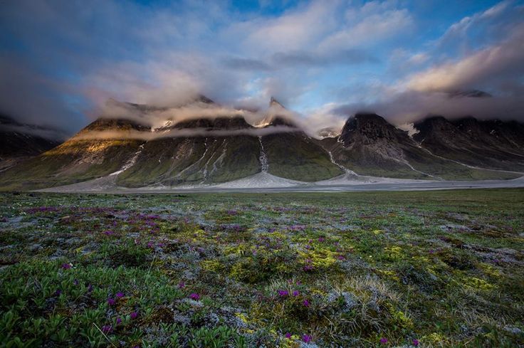
Victoria Island is the second largest island of the archipelago. It has the shape of a maple leaf – and this counts for something in Canada, far more than it being (reportedly) the 8th largest island in the world. There is a range of low mountains in the northwest of the island, with a plateau of basalt. The Kuujjua river has cut canyons in the basalt. Elsewhere there are patches of tundra, and a few shrub dwarf woods where the birch trees grow a staggering 50 cm tall. In spring and summer, the snow melts and the tundra comes to life with green mosses and lichens, and small plants with purple flowers.

Victoria Island is cold now. It was even colder in the past. During the ice age this area was covered by a thick glacier. When the glacier melted, the ground began to rise. There are now beaches 150 meters high above the current coast. Parallel grooves carved in the bedrock shows the scouring by the old glacier. Glacial debris and dropstones complete the evidence for the long winter of the ice age.
Christmas is the darkest time of mid-winter (well – at least it is in the north). There are months of cold still to come, but there is hope, or rather certainty, that the winter will pass and spring will come. But the ancient ice age seemed to last forever. Century after century, Christmas after Christmas, the cold remained and the ice thickened. It took tens of thousands of years for the melt to finally begin. The memory of that time is still all around on Victoria Island. But so is a far older memory, of a time when not just the north but the entire world was under the rule of the White Witch, beyond any hope of recovery.
Victoria Island is where the world ended. Here is where it began.
Advent
The rocks and stones of Victoria Island date to ancient Rodinia. This supercontinent formed around 1.1 billion years ago and existed until 700 million years ago; for much of that time it straddled the equator. Somewhere in the northern half of Rodinia was a basin, which collected sediment. This in-land sea sediment became (amongst others) Victoria Island.

Rodinia. Image from wikipedia
The sediment, now turned to solid, hard wearing rock, contains evidence of a major volcanic episode. The remains of sills, dikes and lavas are seen on the western side of Victoria Island, north of Prince Albert Sound. At least 13 separate sills intruded in the bedrock, with thicknesses between 5 and 100 meters, continuous over as long as 40 km. Many dikes exist, up to 40 meters across, and there are also remnants of thick surface flows. Little is left after so much time. At one time, lava as much as a kilometer thick spilled out, covering the future island in an ancient flood basalt. The sills have been dated to 716 million years ago.

Victoria Island, Canada
A flood basalt is also called a ‘large igneous province’. To avoid any risk of misspelling, it is often abbreviated as ‘LIP’, a term which can be used for either the completed lava sheets or for the eruption itself. A LIP is given a geographical name. This particular LIP covers the entire area of the District of Franklin (abolished in 1999) which covered the Canadian high arctic including Ellesmere, Baffin and Victoria Island. The District was named after Sir John Franklin, the unfortunate explorer who perished within this LIP. His name is now attached, perhaps a bit unfairly, both to the largest disaster of polar exploration, and to one of the biggest catastrophes the world has ever seen.
The Franklin Large Igneous Province has left traces in surprising places. The Coronation sills on the Canadian coast belong to it. The large igneous province around Irkutsk, southern Siberia (think Lake Baikal), which stretches from the Yenesei to Dovyren (‘Y’ and ‘D’ on the figure; ‘B’ is Baikal), has the same age, and is now considered as part of it. It So does the Kikiktat flood basalts (‘Ki’) on the North Slope of Alaska. The continents have been re-arranged, of course: at the time both Siberia and Alaska were rotated and the north slope of Alaska and the southern part of Siberia were attached to Canada. (How times have changed, even more so when you realize that at the time the area was located on the equator!)
The sills and dikes across the arctic formed about 720 million years ago. The oldest dates are around 723 million years and the youngest 716 millions years. Flood basalt eruptions typically last 1 to 5 million years – Franklin, being a large LIP, may have been at the upper end. Victoria Island has the younger dates, and may only have experienced the final part of the entire event.

The dike system of the Franklin Large Igneous Province. The positions are shown as they were at the time of the eruption. MH: Mount Harper; Co: Coronation sills; Ki: Kikiktat (now Alaska); B: Baikal (Siberia). From Ernst et al. Long-lived connection between southern Siberia and northern Laurentia in the Proterozoic. Nature Geosci 9, 464–469 (2016)
The two basalt areas on Victoria Island (see below) are known as the Natkusiat basalt: they are the only remaining surface flows or the Franklin LIP. Originally the lava sheets must have covered a far larger region, approaching the extent to the dike system. But they only survive on Victoria Island. The rest is either eroded away or still lies buried underneath younger deposits. The area of the Franklin flood basalt is at least 2.5 million km2. It covers 10% or more of the combined Siberia-Canada craton.
Franklin is one of 300 LIPs known in the past 3.5 billion years. It is quite large even for a LIP, at four times the size of the Deccan. For comparison, the Siberian Traps and the CAMP, the largest known, each cover between 4 and 7 million km2. An interesting accident is that Canada hosts another flood basalt of almost the same size: the MacKenzie LIP from 1.27 billion years ago. The Franklin LIP partially overlaps with the older MacKenzie, and the plume centre of the MacKenzie LIP may, in a twist of history suitable for a christmas cracker, have been located at Victoria Island. Some places have all the luck.
Victoria Island was not the centre of the Franklin LIP, however. The dikes fan out from a location further to the north, somewhere in the western arctic. The exact location is difficult to define. Dikes on the Canadian mainland point at a focal point northwest of Banks Island. But other dikes suggests that the centre was further east. Either way, this was in the heart of what remained of Rodinia.
Rodinia broke up (supercontinents always do) in stages between 900 and 700 million years ago. At the time of the Franklin eruption, many parts had already gone their own way. The Franklin eruption was located on the border between Laurentia and Siberia. The fact that the dikes crossed into Siberia shows that the two were still connected, rather than (as normally drawn) with Siberia at some distance. The last surviving part of Rodinia would break apart at this very location. Naturally, the Fanklin LIP is held responsible for this final demise of Rodinia.
This unwanted Christmas present initiated the separation of North America and Siberia. Afterwards, these two continents went their own way and Siberia rotated away, ready to leave. But it didn’t go far. In fact all three arctic continents, long before they became arctic, remained closely knit: Baltica, Siberia and North America were like partners who could neither live together nor apart. Think Shrek, Fiona and donkey. Or, perhaps more in tune with the season, the three wise men: they traveled together, but the story does not say how they got along. Wisdom can grate and wise men can argue too much. We value experts but don’t necessarily like them.
Arrival
There is evidence that before the Franklin volcanism began, there had been uplift. Beginning between 10 and 20 million years before the eruptions, Victoria Island had been rising as part of a big dome. The doming is attributed to a mantle plume. The size of the dike system also suggests such a plume. A large mantle plume will spread out where it hits the lithosphere, and form a mushroom head with a size that can reach 1000 km in radius. This is indeed approximately the area of the Franklin LIP.
The doming may have been centred several hundred kilometers north of Victoria Island. The remnants that we have in Victoria Island are at the outer edge of a much larger structure. In the dance of the plates, the center has been lost. It may be hiding in an unexpected place – we don’t know the make-up and break-up of Rodinia well enough. It could be on the ancient cratons of China or Australia, both of which were in the general area. Or the old centre has been erased in a later mountain-building plate collision. We only have fragments of our past, and it can be hard to piece together the historical events from those fragments. Too much is gone.

From Williamson et al., 2016. The Franklin LIP on Victoria Island. Green: basalt; orange: older sandstone; yellow: sandstone of a flood plain just prior to the eruptions
Studies of the surviving lava flows on Victoria Island (green on the figure) shows that parts rest on the sand from a river flood plain (yellow). The river was flowing to the northwest, and brought sand which had been eroded from higher land to the southeast. This sand contains basaltic and other volcanic fragments, which apparently were still warm when deposited. There had been volcanic activity nearby before the basalt of Victoria Island was erupted. The same sand layer also shows disturbances: these indicate there had been frequent earthquakes.
The rise of the land shows that magma had collected below the crust. Long, approximately vertical dikes formed. Some dikes became deflected and formed large horizontal sills in the crust, tens of kilometers long. The sedimentary rock became riddled with these sills and dikes. The rock was rich in sulphur, dating from the basin in Rodinia where it formed. The magma in some of the sills, picked up this sulphur from the sediment.
The eruption itself consisted of three phases, over a long period of time. The earliest flows at Victoria island were in shallow water, perhaps lakes or ponds. They formed some local halyoclastites and a few pillow lavas. The water quickly disappeared: subsequent flows were rubbly but not wet. Each flow was between 1 and 10 meters in thickness. The top of these flows is weathered, showing there was considerable time between individual flows. The flow rates were not high and the flows are not wide. This suggests that this phase was fed by small, separate vents or fissures, each erupting at its own time.
In the second phase, volcaniclastics (think lahars) filled in a valley in the lava field, perhaps 50 meters deep. The valley may have been tectonic, grabens caused by magma intrusion, which would imply a long hiatus after the first phase. The first debris avalanche came from the edge of the valley and brought only debris from the lava field. The second one came from further away and was carried by water, indicating a river had started flowing over the lava field.
Now the real thing began, the third phase with much larger sheet flows, typical of a flood basalt. Three flows are recognized in the southern lava field of Victoria Island, with a combined thickness of 70 meters. The lower one is recognizable along a length of 25 kilometers. The northern lava field has four further sheets on top of these three, which are absent in the more deeply eroded southern field. The uppermost of these sheets is more than 150 meters tall. Each sheet consists of multiple flows: in the northern field, the five sheets together contain a minimum of 34 flows. Some of the individual flows can be traced over more than 30 kilometers.

From Williamson et al. 2013, https://publications.gc.ca/collections/collection_2013/rncan-nrcan/M44-2013-16-eng.pdf. The southern lava field. Kj is the underlying sand stone, V0 the first phae, C1 and C2 the two volcaniclastics and V1A-C the sheets flows.
The earliest lava was similar in composition to ocean crust with up to 10% continental crust melted into it. Later flows had less continental pollution, and as the melt became more and more voluminous, the lavas became more homogeneous. But this was deep within Rodinia: where did the oceanic crust come from? Isotopic ratios suggest that this oceanic crust was quite old (or ‘mature’). The heat from the plume melted the lithosphere below the continent, and perhaps the upper mantle. The lithosphere had retained material from a long-subducted oceanic plate, most likely a remnant of the ocean that had been lost when Rodinia was assembled. It is sobering to think that this 700-million year old lava field, deep in the Canadian arctic, was made from an ocean that was lost more than a billion years ago and which has seen the underside of Rodinia.
All this was a side show: the real centre of the activity was hundreds of kilometers away. The event left a scar even below the continent. Seismographic imaging has shown that the deep root of the Canadian craton comes to a sudden end underneath the northern shore of the Prince Albert Sound. The Franklin LIP split the craton top to bottom. Rodinia now came to an end as the continents on either side of the developing rift drifted away.
Solstice
Life goes at its own pace. It can’t be rushed. The Franklin eruption occurred in a world that was poised for the future, but reluctant to enter it. Simple life (single cells) has existed since some 3.5 billion years ago. When photosynthesis developed, it led to the first major environmental crisis when its waste product (oxygen) turned out an indiscriminate killer. It almost ended life altogether. Eventually life developed ways to cope with, and even make use of, this highly poisonous molecule.
The great oxygenation happened 2 billion years ago. But after the initial spike, oxygen levels had dropped back again and a billion years followed of low oxygen (perhaps 1-2%). Life was hanging on but nutrient levels in the ocean were very low. Much of the sea was anoxic, and mainly supported sulphur-eating bacteria. This sulphur is still seen in the sills of Victoria Island. The climate was pleasant, with temperatures a few degrees higher than nowadays. The atmosphere was not, with very little oxygen, five to ten times higher CO2 than nowadays, and significant methane and nitrous oxide. But change was coming. Stromatolites, build by cyanobacteria, disappeared 1 billion years ago, perhaps because of grazing, from a new life form which had developed. Microfossils became more diverse. Their origin is not known but they may come from algae. Bacteria ruled the waves! 800 million years ago the first animals evolved. Don’t hold your breath (however tempting in that atmosphere): these were only the forerunners of the sponges. But it was sign of what was to come.
If you wonder how such a high level of greenhouse gasses could keep the Earth no warmer than 4C above current levels, the Sun was fainter in those days. And as Rodinia was breaking up, those CO2 levels were falling. Winter was coming. And what a winter it was. It even was given its own geological name: this was the time of the Cryogenian.
In the years before the Franklin eruption, the climate had become variable. Models suggest that global temperatures may have been a little cooler than today. There had already been some excursions to even cooler climates. One study finds evidence for a glacier in southwest Virginia, about 750 million years ago, at a time Virginia was tropical. This was likely a mountain glacier, and it has been suggested to be associated with rifting, perhaps akin to (but lower than) the Mountains of the Moon along the Africa rift valley which nowadays carries glaciers. This brief cold phase is now known as the Kaigas glaciation. A bit earlier, around 810 million years ago there was a longer phase of colder weather known as the ‘Bitter Springs’.

From MacDonald et al. 2010, Calibrating the Cryogenian, Science Vol 327, pp. 1241-1243. Mount Harper glacial indicators. Top: glacial dropstone; Middle: Striations caused by a moving glacier; Bottom: Soft sediment which has been folded underneath a grounded glacier.
Why had the climate been cooling, after the warmer days of early Rodinia? There are two reasons. The continents had all moved to tropical and subtropical latitudes. Land reflects more radiation than the sea, and with the continents on the equator where most of the sunlight falls, the Earth now reflected more and retained less solar heat. And as Rodinia began to split, the climate may have become wetter (supercontinents have dry interiors) and this would have increased weathering. Weathering of rocks removes CO2 from the atmosphere, so the CO2 content was going down a bit: there was less greenhouse warming. This is common when supercontinents break up.
However, this was no ice age. With the continents clustered around the equator, large glaciers could not form. The sea near the poles might freeze, but snow had nowhere to settle. There would be no white Christmas – and certainly not at tropical Victoria Island.
Not far from Victoria Island lies Canada’s Yukon territory – at least, it is close enough to be in the same country. Rocks of the time of the Franklin LIP are exposed here in various locations stretching to the Alaskan border. And these show unexpected features. Around Mount Harper, there are scratches on the rock, similar to those seen on the modern-day Victoria Island, left by recent ice. A layer of diactimite is seen: a layer of sediment containing unsorted fragments up to boulders in size. This is the kind of sediment that can come from a glacier. Debris and dropstones show evidence for a floating glacier. The conclusion was unavoidable: Mount Harper had been near the grounding line of a marine glacier.
This glacial deposit has been dated to 716.5 million years ago. Mount Harper lies within the area of the Franklin dikes, and therefore already was close to Victoria Island. The lava at Victoria Island has kept the direction of the magnetic field of the time. From that, we know this region was no more than 10 degrees from the equator. That Mount Harper glacier was floating on a tropical sea.
Evidence for this glaciation has been found around the world, in Africa, Australia and America. They all tell us the same story of sea-level glaciers in the tropics. The ice had reached everywhere and the sea had frozen from pole to pole and from shore to shore. No open sea remained anywhere on Earth, not even the most remote ocean. The long winter had begun. Victoria Island finally had its white Christmas.
Epiphany
We have long known that the Earth is living precariously. Modeling shows that there are three stable types of climate that the Earth can have. One is what we have, where temperatures are moderate, the seas are open, and snow and ice are found only at higher latitudes or not at all. There are excursions to more extreme temperatures, as there were during the ice age or from our attempt at global warming, but these are within the range of this type of temperate, liveable climate which we depend on.
The second climate type is that of the White Witch where the entire Earth is frozen. Open oceans absorb a lot of sunlight and turn it to warmth. Ice, on the other hand, reflects most of the sunlight. A frozen Earth would have a stable temperature far below freezing, all over the globe, kept that way by the reflecting ice.
There is a third stable climate but we don’t want to go there: evaporate the entire ocean and we get a steam atmosphere where the blanket of moisture keeps the temperature high enough (several hundred C) to keep it that way. Somehow the Earth has avoided both extremes and kept temperatures at the moderate level which life can live with, over a staggering 4 billion years. For much of that time, the Earth was an ocean planet with only small pockets of land. Oceans are excellent at providing stability. But over time, the land areas had grown and had reached continent size. Land creates climate instability: it has low heat capacity, and the temperature can fluctuate rapidly. And now all this land was in the tropics, and much of the sunlight falling on Earth fell here. Franklin erupted into this world of danger.
The temperate climate had been lost. In an ice age, the whiteness of the ice and snow keeps the temperatures low, and allows the glaciers to creep towards temperature latitudes. Models show that if sea ice were to reach 30 degrees latitude, the expansion becomes unstoppable. Temperatures plummet, and within 200 years the sea ice will have reached the equator. A few thousand years later, in those models the ice is several hundred meters thick across the entire world ocean. This had come to pass.
The global freeze had begun immediately after the Fanklin eruption of Victoria Island. Somehow, this flood basalt, among the largest continental flood basalts known, had tipped the Earth into a snowball. We still don’t quite know how the LIP did this – other, even larger LIPs never managed. There are some suggestions. The Earth had already been relatively cool, which helped. The Franklin eruption was quite sulphur rich because of the sedimentary rock through which it erupted. The sulphate in the atmosphere may have cooled the planet. The problem with this is that sulphate drops out of the atmosphere quite fast and if the eruptions lasts very long (centuries), it has to compete with the CO2 which the eruption also produces.
More likely is CO2 scrubbing. Volcanoes put CO2 into the atmosphere – flood basalts therefore often go together with a strong bout of global warming. But later, they can remove CO2 again. This is because basalt, when it weathers, takes up CO2. The suggestion is that this scrubbing had been much stronger than usual after the Franklin eruption, firstly because the basalt covered such a large area, and second because it erupted in the tropics with high rainfall and therefore high weathering. The result was that after an initial CO2 spike, levels began to drop – and reached values well below those of before the eruption. As CO2 fell, temperatures did too, sea ice expanded and snow began to settle on the fringes of Rodinia. When half the ocean was covered by ice, the planet’s fate was sealed.

Let it snow, let it snow
The ice catastrophe may have been an accident. The Franklin eruption had been going on, intermittently, for one million years or more. But now it was in its declining phase. Basalt was weathering and CO2 was going down. At that moment, in a final flash, Victoria Island erupted its sulphuric magma. This caused a sharp, temporary drop in temperatures. This drop was enough to push things over the edge, perhaps allowing glaciers to form in parts of Rodinia. It never recovered, and the volcanic winter became a permanent one.
And so the ice came, the snow fell and the world turned into a frozen, lifeless desert. The bleak winter would last for 50 million years.
The bleak mid-winter
With the sea frozen, the continents covered in snow and CO2 at record low levels, temperatures plummeted. The average temperature over the year quickly dropped to -40C, even at the equator. These temperatures are predicted by climate models, but have been confirmed by the study of oxygen isotopes in rocks of the time. The poles were far colder, with an average annual temperature of -80C and midwinter temperatures of -110C. It was like living on Mars. Summer temperatures were a balmy -20C at all latitudes. There are no seasons in the tropics, and the cold here was year round. The sea ice grew to a thickness of over 1 kilometer.
From space, the Earth would have appeared white. This is called a ‘Snowball Earth’ – for obvious reasons. Snowfall was sparse, as cold air contains very little moisture. The whole Earth was a desert. But much of modern Antarctica is such a cold desert, and still it has been able to grow enormously thick glaciers. Even a little snow can build up if it never melts.
You may wonder how there could have been any snow at all when the main source of moisture – sea water – had been locked away below the thick sea ice and evaporation of water had stopped. But ice could also sublimate into vapour, bypassing the state of liquid water. Sublimation happened mainly at the tropics, with the Sun directly overhead and no clouds to shield it. A reversed Hadley circulation channeled the moisture to the subtropics where it became snow. Glaciers could thicken at a rate of a kilometer in a million years. That rate was high enough for the glaciers to start moving, but the ice growth was 10 times less than that in our modern ice ages. Models show that the glaciers covered the entire supercontinent within 200,000 years, apart from a few coastal strips. Sometimes the glaciers would surge (very slowly) seaward; at other times there was a sudden retreat, leaving sand exposed. Meltwater would flow underneath the glaciers, just as it does in modern glaciers. The air was dusty, dry and cold. And so it continued, year after year after year, in this everlasting winter.
But during this winter, there was a slow change, imperceptibly at first but becoming larger as the season grew older and the ten million years of December turned into the ten million years of January, and then February. For this was a broken Earth. In our modern world, CO2 is kept at bay through weathering of rocks and through the carbonate cycle of the oceans. There is a balance between how much CO2 is produced by volcanoes , and how much is removed from the atmosphere. But this cycle had been broken. Volcanoes remained active, breaking through the ice in immense eruptions. But the CO2 they breathed out was no longer removed from the atmosphere. CO2 can dissolve into rain, but not into snow. There was no weathering of rocks and there was no open water. What was added, stayed added because of a lack of subtraction. And so CO2 began to multiply, from 1000 ppm (0.1 mbar) to 10,000 and then 100,000 ppm. It still wasn’t enough to fully counter the enormous reflectivity of the sea ice, and Winter’s rule remained undivided. But temperatures slowly went up from their early extremes. Eventually, March came and during the afternoon, for the first time in 50 million years, the temperature rose above freezing. There was hope of a Spring.
During those millions of years, the rising temperature had already changed the land. Glaciers were retreating and more of the land became ice free. Even at 10,000 ppm, the open land remained limited to the equator, but at 100,000 ppm, most of Rodinia had become bare. But the ocean was still a wide expanse of ice, thinner than before but still frozen solid. At 100,000ppm, the sea glacier was still 500 meters thick on average.
The ides of March
But change was in the air. Once CO2 had increased to 200,000ppm, tropical average annual temperatures were above freezing, sea ice at the equator began to melt from the top, and open water appeared. This water did something that had been missing for a very long time: it absorbed rather than reflected sunlight. When this open water lasted year-round, the winter reached its end. The sea warmed, and more open water appeared. The sea ice began to retreat towards the poles. The change was now unstoppable; the retreat accelerated and within only 2,000 years, even the poles had become ice free. Spring had arrived.
It was a catastrophe. Rain was now falling and CO2 was being scrubbed from the atmosphere. But half of all air was CO2, and the scrubbing took too long. Temperatures were rising, at first welcome but soon the rise became too much. A torrid greenhouse developed. The oceans melted, warmed, and kept warming. Water temperatures reached between 40C and 60C. The warming water expanded, and sea levels rose by 50 meters. Much of the coast became deeply flooded by the unbearably hot water. The Earth was out of the frying pan into the fire.
The flooded coast came to the rescue. The hot water was highly oversaturated in carbonates, caused in part by tens of millions of years of volcanic activity along the mid-ocean ridges and in part by run-off from the sudden weathering in the continents. The carbonates came out of the water, and were deposited on the continental shelves. It is seen as a distinct thick cap on top of the sediments left by the Snowball Earth glaciation. Eventually CO2 regained its equilibrium. The Earth finally became habitable again, ready for a very long summer.

Source: http://www.snowballearth.org Cap carbonate in Namibia, following the second Snowball event. TST (CD): dolostone; MFZ: limestone of the maximum flooding stage; HST, flaggy limestone and dolostone grainstone
But the long summer did not last. Perhaps this was all a false spring, the pleasant week in March before winter returns with a vengeance. After 10 million years, for reasons not well understood, the temperatures dropped again. Glaciers reformed, and sea ice again advanced. The continents were still close to the equator. History repeated itself: eventually, the ice again enveloped the globe in a snowball Earth. It stayed that way for another ten million years, before spring finally took hold. The Earth’s long summer had begun.
Life in the freezer
How ever did life survive the snowball? Where could it have survived, with the continents covered in glaciers, the sea frozen to a kilometer depth and the waters below pitch dark, hypersaline and anoxic? How did photosynthesis survive without photons for 50 million years? We still don’t know. Deep water creatures will survive near black smokers on the sea floor, but these do not photosynthesize.
There are suggestions. Some have suggested that areas of open water existed throughout the snowball in the warmest regions near the equator. These are called ‘loophole’ or ‘waterbelt’ models. But physics is not encouraging. There is no obvious way to stop the ice spreading out and filling in any gaps. The most promising waterbelt model is one where the ice is deemed to be much less reflective in the tropical region. This can give a ten-degree wide belt of water which migrates back and forth with the seasons. However, there is no clear reason why the ice here would be less reflective. Cracks in the sea ice are a perhaps more plausible alternative. They are seen on Europa, the ice-covered moon of Jupiter. They would require that life can quickly jump from one random crack to another, half a planet away.
Other ideas ignore the ocean and focus on the surface. Perhaps liquid water could exist on top of the ice. A possibility is dust. A dry world is a dusty world, even if only from volcanic ash. Over the entire globe, the dust layer would increase by one to ten meter per million years. Left alone, the dust would be 300 meters deep by the end of snowball Earth; wind would bring it mainly to the tropics. Clearly, something recycled all that dust. Perhaps every now and then the ice would collapse and turn over, as it does in sea glaciers around Antarctica. Dust on the ice will absorb sunlight, melt the underlying ice, and sink in. Quickly it develops pockets, and later ponds, of typically half a meter deep, which can be filled with liquid water and covered with thin ice. In this way, an equatorial dust band could provide the conditions for life to continue, and for photosynthesis to take place, without the need to artificially keep the equatorial ocean ice-free. It would also explain why the atmosphere never became fully anoxic, even during the depth of snowball Earth. Life in the cold ponds would be slow, but possible.
The final models propose that life continued on land, in ice-free locations perhaps similar to the dry valleys of Antarctica. Could cyanobacteria perhaps survive millions of years of complete dessiccation?
Later in the snowball, the slowly rising temperatures would make the presence of liquid surface water more likely. The coldest period during the first ten million years would be the most difficult to survive.
Summer
In the end, life survived everything life threw at it. Fossils show that the diversity of life suffered tremendously: there is a poverty of species, and low numbers, in the fossil record of the snowball Earth and of its immediate aftermath. But the recovery was spectacular. When the Cryogenian ended, the next geological epoch was ready to go: the Ediacarian. This was the time of the most amazing fossils, which look like nothing we know today. And after that came the Cambrian, with the explosion of life which Darwin already wondered about. After the Christmas flood basalt of Victoria Island, and the long winter with its false spring, came the real Spring where life sprang to new life. And after that came Summer, the never-ending days of warmth and of dinosaurs and of birds and mammals, the playtime of the Earth.
The Sun is brighter now than it was in those days, and there may never be another snowball Earth. But it is good to remember. Once, long ago and far away, a volcano brought a winter which almost ended life on Earth. Other volcanoes brought back the warmth, but it took a long long time and the recovery almost brought its own disaster. Life survived hanging by a thread. But survive it did, against all odds, and how it flowered in the next season of the Earth.
Victoria Island, in winter a place of desolation and human suffering, in summer springs to life when it becomes a place of wild beauty. It is a place of hope.
Albert, December 2021

A Christmas puzzle
To provide hours of entertaining: trace the curved line

(addendum, June 2022) For the latest on snowball Earth: https://www.nature.com/articles/s41561-022-00950-1


Happy Christmas to everyone!
As all your contributions this one is one more gift ! Many thanks and happy christmas to you
Happy Christmas!
Another Jesper sized volcano 🙂
There are quite a lot of quakes showing up with depths of less than 2 km now at Fagradalsfjall, I think it is getting very close. I think an eruption with larger magma flux would have already begun by now even, so this one will probably be a fairly slow event again, and probably last for a long time as well, at least months like before, and we will get many such eruptions like it over the next decade.
It appears that most, if not all, of the shallow quakes are very small ones at Fagradalsfjall but then I suppose that is to be expected as most likely there will be less pressure needed to break open any previous pathways the magma now chooses to use to reach the surface. It is good to see that most quakes are staying in the Fagradalsfjall now and keeping away from the Grindavik area. Last nights quakes to the north of Grindavik were concerning due to the row of small cones from previous historic eruptions.
Yes there is only magma in the Fagradalsfjall faults, but the activity there is causing more quakes at these other systems, there is another swarm going in Krysuvik on the other side of Fagradalsfjall too. Both Krysuvik and Svartsengi will erupt eventually in this cycle but not yet.
Grindavik is probably still not entirely safe though if we get a bigger flow from Fagradalsfjall or lava tubes form, it is only 10 km away along the likely flow axis, flows from Pu’u O’o easily flowed this far (up to 24 km) at only half the effusion rate.
Jesper Sized : D ?
The only active JS sized volcanoes today is Ra Patera, Pele Patera, Loki Patera, Surt, Twasthar Catena and Amirani Fluctus on Jupiters Moon IO
But it hardly passes for me either
Merry Christmas to everyone!
Merry Christmas !!!
And thank you for all of the comments, reports and informations you’ve all contributed here.
Happy Christmas and best wishes for 2022 to our VC Dragons and all VC readers!
And thank you for another fascinating article, Albert!
Merry Christmas to everybody!
Merry Christmas, especially to La Palma.
Today is the day the eruption is officially declared over. A step towards recovery.
Happy Christmas All,
and may 2022 be better than 2021.
Merry Xmas and all Best Wishes for the New Year to everyone .:)
Merry Christmas everyone.
And thank you for another year of brilliant articles and interesting and informative debate in the comments.
Happy Chrismas…
La palma eruption has officialy ended…
Merry Christmas from snowy northern Norway !
OT, James Webb telescope managed to leave earth just fine, iiihaaaa 🙂
Albert, thank you for the wonderful Christmas present. I understand the gist that volcanoes played a huge role in the major climate shifts. Do major impact events have much contribution? Cause a tipping point between the three states of stability?
Any scenario (the sun dimming?) elsewhere in our solar system where there could be a climate state change? Venus? Europa?
We don’t really know, I think. Impacts do not produce CO2. The atmosphere received a lot of instantaneous heat. In a supermassive impact, the atmosphere would be vaporised rock which clearly is not survivable. But those haven’t happened since the Moon formed. The dinosaurs were wiped out by a very large impact. But birds survived, so conditions were survivable at least somewhere on Earth. If another snowball Earth would occur now, nothing more complex than bacteria would survive. Complex life (i.e. multi-cellular) is much more fragile than single cells are, and therefore requires more stable conditions.
Thats true as Albert says Impacts are very brief events, and brief effects that can be catastrophic.
Chicxulub ( 15 km wide asteorid)
was bad enough burning most of the planet by ejecta that reenters the atmosphere and causing alot of thermal radiation to the ground.
Perhaps as much as 50 000 km3 of hot hypersonic ejecta fell back on Earths Atmosphere dumping their kinetic energy as atmospheric heating. Must have been an Incredibley Magnificent sight for soure, watching the ejecta come back into the atmosphere as trillions trillions of meteors high above .. litting the upper atmosphere in a blast furnace glow. Tanis Site in Hell Creek records the impact in detail. I woud give almost anything for a time machine To see the KT boundary extermination by own eyes
Larger impacts than Chicxlulub
( 40 km wide Asteorid ) have not happened since Archean .. and they are probaly so Severe that the landmasses gets totaly incenirated and the oceans uppermost layers boiled. Only Sea creatures can surivive souch an impact, and perhaps Earth woud enter a Venusian hothouse If souch impact happens again.
Even larger impacts than that
( 200 km wide Asteorid and above ) are so Severe that the oceans boils and continents upper surface meters melts To glass and Earths surface is sterilized. At 500 km wide rocky object at 30 km a second, you boil away the oceans competely, leaving Earth with a superhot atmosphere of rock vapour and steam, the lost oceans reform When the planet cools and the water Re – condense later after impact. That was the Late Heavy Bombardment.
Even larger impacting protoplanets That happened in Hadean may melt the entire outer litosphere and Earth haves a rock vapour atmosphere as Albert says. During large planetary mergers the entire Earth maybe mostly liquid.
Still Life itself can surivive very very large impact events, because Earths crust have very low conductivity, and microbes can shelter kilometers underground from the heat above. Hadean Bacteria likley survived underground when Earth was hit by 600 kilometers wide protoplanets, The surface was competely sterelized and enveloped in rock vapour, But kilometers underground its quite cool. These ancient bacteria surivived many large ocean boiling impact events. To sterilize the planet, you needs to melt the entire planets crust down to many 10 s of kilometers, that woud require a moon sized impactor perhaps. One earth was Colonized by its own life, it was there To stay
A really Big impact coud have easly ended the snowball Earth, althrough that requires a very very large Impactor to put in that energy. And that did not happen during the cryogenian. But it woud not work anyway, after the planet cools again after the impact, the Ice reforms.. IF the impact did not raise CO2 levels
Snowball Earth phases was indeed ended by volcanic outgassing, as the CO2 from volcanoes built up in the atmosphere as the Article says
A very very very large impact today may Send Earth into a venusian hellhouse that it cannot recover from, If enough water vapour fills the atmosphere. And an ocean boiling impact woud not be recoverable today perhaps because the suns luminosity have increased. But No souch impactor are on collision course for now
Far Future greenhouses by volcanic outgassing will be Severe , because the sun is brigther now, and global warming gasses are even more effective now than it was during cryogenian era
There appears to be increased steaming at Geldingadalir volcano. It even appears to be wispy smoke at times. It could of course be weather conditions making it more apparent than normal but worth watching from time to time.
Sorry I forgot the link.
Could be the approaching magma is reheating stuff!
Yes that would make sense Clive. The insides of those walls must still contain a lot of residual heat. Colder weather can also cuase increasing steaming too I would have thought.
And is it my eyes or am I seeing red at times on the right side of the cone? I am developing ataracts so cannot fully trust my eyesight at the moment.
YAY!!!! It is red showing at the top right or the cone now! I got my son to check and he confirmed it was red there.
Oh boy, it looks like some steam/smoke started pumping out of the lower lava field way left in this panoramic cam.
Its def growing in strength since i spaced out watching it on my tv…
Merry Christmas.
Pretty sure it just started erupting!
May have jumped the gun, centre of camera it looked like fire. Probably an artefact or reflection distant lights. Have just woken up after a few gins earlier.
I think you could be right. That is definitely steam and not in a good place at all. Really hope it is all a mistake down there!
Whoopie. Game on. the far right of the cone is showing red cinders.
Nothing on the panoramic camera. I doubt it is ready to do anything just yet, because there is no tremor. Just seismic noise.
Maybe I’m blind….
Double checked – zero. Not even the Aurora. Sorry to put a downer on it. I am as keen as you all to see it.
That smoke in Nattaghi has been there for months; it is the bottom of the steep lava slope so I guess there’s a nice hot pool of gooey lava steaming away down there.
Haha Clive, now worries about putting a downer on things. Certainly though I haven’t before seen those glowing cinders at the top right edge of the cone. However what I thought might be flames is probably just the wind blowing the steam past the hot areas. Possibly the shaking of the large quakes tumbled some rocks from the top and the wind is keeping them glowing. My fertile imagination thought the cone must be filing with magma again. Not looking so likely now though. 🙁
It is hard to be sure, but I guess this is a small collapse which has exposed the subsurface, still hot from the past eruption.
Merry Christmas to all!
Is Skjálfta-Lísa (skjalftalisa.vedur.is) down? I haven’t been able to connect since yesterday. It’s frustrating to lose such a great tool in the middle of a nice swarm.
Oh, speaking of great. Great article Albert! Snowball earth sounds like a scary place.
SB Earth was terrfying, a real Hoth, But luckly the atmospheric carbon cycle shuts down and that allows CO2 from volcanoes to build up in the atmosphere without being scrubbed away.
Snowball Earth woud be very much like interior of Antartica. Perhaps the sun and the moon tides woud form Europa like fissures on Earths icey surface back then? Earth was an Europa back then, just with an atmosphere and not so much water
Europa haves seafloor volcanoes too But its too small and cold to get an atmosphere on the surface
Interesting thought, thinking of snowball Earth as a kind of Europa…
My guess is this place would not have a full ice crust, just extended glaciation. But it is an interesting thought, Jesper!
Snowball Earth was indeed like Europa. Perhaps the post wasn’t clear enough. Evert bit of ocean was covered by a kilometer of ice. In Europa it is 50 kilometers, so it wins. But from space the two would have looked very similar
Guess it’s down. IMO have not been confirming eqs on https://en.vedur.is/earthquakes-and-volcanism/earthquakes/reykjanespeninsula/#view=table as rapidly as usual.
Christmas break?
Not as risky as it might appear; they know where the dike is. Given the aseismic zone in the Icelandic crust, it is anyone’s guess where any lava may emerge.
Thank you for the interesting Christmas present, Albert, that I have to read a little later, and Merry Christmas to all!
The swarm has slowed down a lot now, in March we all thought this meant it was dead but it erupted shortly after, even within hours of it being predicted to not erupt 🙂
I think what this sequence shows is the supply rate from the deep conduit is continuous and said conduit is open up to the depth of where quakes start. It is not so high it can keep the dike open forever though so it stopped when the pressure got too low. Now it is recovered, I guess it will just keep doing this until either the conduit can fully open to the surface or the supply of magma stops (or until the end of the cycle when it might be forced to stop regardless).
Either way I am in no doubt we will see more eruptions, it is probably going to be the most frequently erupting volcano in Iceland for a good while.
Exactly.. now its stopped cutting through the ground, and it Will fill up instead and go towards the surface of the force cannot force it through more ground because its too hard. Dykes can be many thousands of km long in LIP cases
If this Intrusion hits ”a hard wall.. ” it will then go towards the surface
https://en.vedur.is/earthquakes-and-volcanism/earthquakes/reykjanespeninsula/
Another pulse of Earthquakes are comming now as the dyke continues to propgation further south
All the new quakes above M3 are actually clustered very tight at the location of the volcano, not going south, I think it is trying for an eruption now and maybe also for a new vent. Was said a few days ago that most quakes were centered under the old end of Geldingadalir, near where the lava spilled from it into Natthagi. If so then we get a whole eruption entirely focussed towards the south instead of a radial distribution, so probably much more risk of the road being cut.
Merry christmas everyone!
Weil, it’s good to see that Iceland might have a little christmas gift prepared for us.
It’ll really be interesting to see if one of the existing vents will be reactivated or a new vent inside or outside the volcanic field – IF it erupts. My educated guess would be the opening of a new vent as eruptions on Rejkjanes tend to be monogenetic. However, this time the elapsed time was rather short.
Apparently is a deep MOHO resovair thats overpressurized and is activated, it coud also be sourge of decompression melting. If it erupts it will be a hot fluid Hawaiian style eruption, will be fun with an ocean entry too
Unlike most volcanic fields though the eruptions are concentrated along narrow fissures, so eruptions in the same place as one previous are not unlikely. There has been at least 4 eruptions on the same fissure right at the end of the peninsula, in at least 2 different cycles. One could also consider a rifting episode as one eruption, even if gaps between lava effusion are more than 3 months. Krafla comes to mind here, all of its eruptions were one one single fissure pretty much, even though there were gaps of over 2 years at times.
At this early stage though only some of the rift has erupted, so new vents will probably open along it, but we will have to wait and see 🙂
Blessings to you all. Merry Christmas.
Merry Christmas everyone! As a present for volcanophiles NASA published satellite images of La Palma before and after the Cumbre Vieja eruption:
The NASA earth observatory article has a direct image overlay with a comparison slider to better see the laval flows and which areas of Todoque and El Paraíso were destroyed:
https://earthobservatory.nasa.gov/images/149231/a-changed-landscape-on-la-palma
Merry Christmas to all, and to all a good night.
Mac
https://m.youtube.com/watch?v=LTOZxPb-UCo Has a new hot spot in the middle toward the right so the cone seems to be heating up?
Just rubble falling down Beacuse of the Earthquakes and exposes the hot interior of the Fagradalshraun shield
Its a very deep pile, it will stay hot for many many decades
I can just imagine how long Puu Oo s pile will stay hot or the much larger Iceland shields like Trölladyngja did after they stopped forming
Hi, notice that yesterday- hasn’t changed-looks very un-volcanic- reckon nothing in it,what ever it is.
Randall hi, notice that yesterday- hasn’t changed-looks very un-volcanic- reckon nothing in it,what ever it is.
It definitely is hot gases (most likely SO2) venting at a low temp of (my guess) 400 deg C, which makes it not visible in the daylight, but seen by the Samsung camera. Whether or not hot gas venting is a prelude to a magma eruption is anyone’s guess.
Read the piece and have to read it again, lots of details. Good pictures.
Wondering whether genetic material can survive deep frozen for millions of years.
You mean viable genetic material? That would be something. At the equator the average temperature was -40C and the ice a few meters down would be at that temperature, constantly. At the poles it would be more like -100C. How long can bacteria remain viable frozen to that temperature?
The lower temperature the longer they stay viable!
Now there is a second swarm at Krysuvik, further up on its rift east of Keilir, all in the last 4 hours at time of this comment. Seems there is a bigger tectonic movement now than a few days ago, all of the fissure swarms are getting pushed around. Maybe this eruption will begin with a bit more power than the last one did…
I think being realistic, there is going to be no doubt in the slightest if an eruption begins. It isnt going to begin so slow it is not clear, there will either be a lava fountain out of the main cone or a curtain of fire along the fissure line, it will be very obvious 🙂
This is movement on the Reykjanes fault. The inflation at Fagradalsfjall has put stress on this fault at either side. Of course this is also a volcanic area and could erupt. But there has been no inflation at this location, so Fagradalsfjall remains more likely. Perhaps January
Yes, Fagradalsfjall is the only place to erupt for now
Fortunately, Snowball earth is only likely when all the plates are together, same with greenhouse earth. Guess i’ll make do with the foot of snow outside my door this morning that magically appeared last night!
Merry christmas people.
Christmas blessings, everyone.
A couple of very amateurish observations about what we’re seeing at Reykjanes:
Has anyone any thoughts about the energy being released seismically as between (i) opening a fresh dike and (ii) reactivating a cooling one? I wonder whether *we* (as opposed to IMO et al. with all their data that we can’t see) would be able tell which the current swarms might signify?
I know that IMO and others think that the activity is probably a reactivation of the spring dike, but the first three of the recent swarms seem to move SW (and less obviously so the more recent one). It’s as though the greater pressure is near to Keilir. The swarms seem to propagate on the SW-erly line of the spring dike but then bifurcate from it in a more SSW-erly direction. This trend seems pretty clear on the time stamped eqs on the Skjalfta-Lisa map.
Currently, this bifurcation seems to be putting most of the activity nearer to a line (roughly) through Stori Hrutur and Natthagi than to the vents that opened last spring. So I wonder whether a new dike is opening, parallel to the spring one, and hence whether we might see an eruption E of Geldingalur.
With 15,000 earthquakes auto-recorded since 21 December 2021, whatever is going on, it means business.
https://en.vedur.is/#tab=quakes
Yes, we too have been wondering about it. The original dike will not cause earthquakes – you only get them in solid rock. So at least some of the path way is new. It is actually easier to break through rock than through semi-liquid magma – think putty: the force of the intrusion is distributed over the full area of the putty and effectively nullified. I think it is a new dike parallel to (and adjacent to) the previous one, perhaps through rock already made brittle by the previous intrusions. Vut that is a guess. IMO may know more
The way I think of it is that the original dike closed shut again except for a single pathway, which eventually closed off entirely. Now the crack is opening again, so it is the same dike but refilled. I guess it can maybe be thought of as like glue between two bits of wood, the original crack is filled in, then it cools down and goes more solid (probably not fully solid though) and now new magma is pushing the crack apart again.
That doesn’t explain where the sizeable earthquakes occured. That can only be in solid rock, while the dike will take centuries to reach that stage. I don’t know, but it seems to me this is not just the old dike reactivating.
Sizeable earthquake because more magma involved?
Thanks, both. I was thinking partly along the lines of what Chad was saying: pressure in the area of the original dike causing earthquakes along that line. But the data seem also to support what Albert says about a new dike E of, and roughly parallel and adjacent to, the original one.
I’ve now had a look at week 10 (= immediately before the eruption) of 2021 on the Skjalfta map. I’d forgotten just how much activity there was under Natthagi. Massive numbers of eqs more or less on the E-erly line Albert and I were discussing.
Early this year, a lot of us were expecting the eruption to be there; that was where one of the M>5 occurred; RUV put a camera there, looking into the valley. There was very little activity at Geldingadalur. But then the activity shifted there, vents 1 and 2 opened and the seismicity went quiet.
So, a first truth is confirmed: volcanoes are unpredictable!
The deformation of this dike adds on the previous one. So the dike seems new. That said it may have started from remnants of the March intrusion. Despite the dike propagated laterally very fast it is taking a long time to increase in volume to grow. It must be widening or growing up now. The March dike took 25 days to erupt if I’m not mistaken, so it may take a long time now too. These are really slow intrusions.
Yes, thanks. I went away from my computer after I started writing my last post, so I couldn´t see yours until after I posted it.
Still getting people up on the hills in Geldingadalir despite being warned to stay away because of not knowing where any eruption may break out. Very foolish. It appears the younger generation do not like to be restricted in any way.
Usually, the ground doesn’t zip open out of nowhere, you can usually see cracks, smoke and hear a hissing sound first. But then you should back of immediately.
It is still silly though because depending on the location, people might find themselves trapped. And then the situation gets very awkward quickly.
The dike is a known location, and pretty narrow, the eruption will not occur on Langiryggur or the top of Fagradalsfjall for example, so those areas are relatively safe. Probably trail A as it goes up past Natthagakriki is not a good area to be though, an eruption could happen there.
Given how long it takes lava to cool down though it is most likely the eruption will happen pretty much at the existing cone, there will still be magma under it. Pu’u O’o was still open after it collapsed in 2018, only completely closing in October of that year, if it was not for such a big drainout it probably would have just restarted there and then. Mauna Ulu also restarted over 3 months later. Then there is Etna, keeping a fountaining open conduit, or rather 4 of them, for the best part of a century now. These things are hard to kill…
Working on my own Volcanocafe article about Nyiragongo
We are looking forward to it. If you get stuck, just send us what you have and we will help you finish it
It will be of descent quality and in my own words completely, But its my first VC article too, so perhaps not fully professional. It will be a full description and debate article of Nyiragongo and its magma it will be longer than the usual VC post, But not too long. But Nyiragongo is a volcano thats defentivly worth to talk about. Nyiragongo is unique and its very dangerous, threatens alot of persons
Writing something also helps me to feel better, souch a horror with my Aspbergers, been a shitty year. Indeed VC is amazing, and finaly I can put my volcano – tougths on the internet forever
I know quite alot about the volcano now since the 2002 eruption intrested me in it as 6 years old back then.
It will be a good article, a look at Nyiragongos magma and its peculiarities. It will be of deep detail but not too fancy here.
I’m looking forward to your article, Jesper. The folks who contribute articles here on VolcanoCafe make it look easy because they are all SO very good at it, but writing is difficult for most of us.
Maybe something to keep in mind when writing your first article for VC is the old saying “done is better than perfect.”
I agree Jimp. I am totally impressed by anyone who would write an article for Volcano Cafe when English is not their native language. Well done Jesper for even attempting it.
Yes working on it, it will be a fun one To write, Nyiragongo and its Nephelinite and hazards is worth to write about!
Its not the largest or most productive volcano, But it is unique in its own ways, with its own peculiarities
A volcano where a fast moving flank drainout can erupt right under the streets of Goma like it did in 2002 for the lowermost fissure intrusion dyke, I remeber fast moving Aa flows going at Running speed shot Here
at 00:41 – 00:47 https://www.dailymotion.com/video/x6b0ao7 that is Scary stuff! When it goes through Gomas sheets at flat ground at souch fast speeds. A child or old person cannot outrunn that
https://twitter.com/j_p_joule/status/1475067181696225282
#Sentinel1 interferograms (here the Des. Dec. 20 – 26) on Reykjanes peninsula confirm that a new dike intrusion below #Fagradalsfjall started with the recent seismic swarm
I hope you’ve had a merry Christmas, lets hope for an amazing eruption for the new year
Sunday
26.12.2021 15:25:18 63.923 -22.071 4.7 km 3.9 99.0 4.0 km N of Krýsuvík
Here you can see a map that shows the inflation between the 22th and the 26th of this month. https://www.ruv.is/frett/2021/12/26/tveir-snarpir-jardskjalftar-a-reykjanesi
https://twitter.com/RagnarHeidar/status/1475151034859331587
Is there likely to be an eruption at Grindavik?
Now? Not likely. This century? Well, that is a different story…
Bravo on article.
Um, La Palma eruption’s been declared ‘over’, Presumably the data support this, but I’d have given it a bit longer…
I was concerned to see on TV news that Crete has had several significant quakes. Snag is USGS report a small pair offshore, which TV news seems to have muddled with prior quakes in region. Upside, is subduction arc, not the parallel volcanic one…
Very bright here in the middle of the pic. Any idea what it is? (wasn’t there an hour ago) https://www.youtube.com/watch?v=EQsXsx1toXE
Very interesting indeed Lorcan. As you say, earlier this evening there was no real bright area there at all. I am afraid I am not at all able to suggest what area that could be or why indeed the light has steadily got much brighter. I have another hour before I sleep so I shall monitor it with interest.
Just checked back on the webcam and at around 18:41 it was quite bright. Then no light showing and now bright again. I am now thinking this may be Keflavik urban area and it could perhaps have been obscured by fog after early evening showing up quite bright. Perhaps someone else may have another explanation.
The bright spots in the image are (I think) from left to right: Grindavik, Keflavik, Vogar, Reykjavik. Keflavik is furthest away and will be the first one to disappear if visibility becomes low. That’s probably why you didn’t see it before.
Yes, could well be a low cloud lit up by a large town. I imagine if something had started happening we’d have heard about it by now – not exactly like nobody it watching this 🙂
Rule of thumb: If you need to ask, it’s not an eruption.
Haha, I love your thinking here Tomas. Lovely name by the way, same as my grandson who has the more anglicised Thomas.
Something I absolutely love about this site is that so far I have never heard anyone denigrate anyones post but all replies have been polite and tried to be helpful. Well done all contributors to Volcano Cafe.
I noticed looking at the quakes that in the last day they have gone in more of an episodic fashion, rather than a constant high background. Is this from magma pushing up or us it the signature of individual swarms surrounding the area?
The majority of newer quakes now are in Krysuvik, at Fagradalsfjall it has slowed, which could be an immediate prelude to eruption. The swarm at Krysuvik is concerning, it is on the same stretch of rift that erupted in the middle ages, which managed to reach outer Reykjavik. It is also concerning how basically the whole peninsula is shaken around, there is magma down there, and this might be enough to let it escape. Fagradalsfjall is a slow erupter but Krysuvik and Svartsengi are not…
Merry Christmas and Happy Holidays Everyone.
https://en.vedur.is/earthquakes-and-volcanism/earthquakes
Slowdown of Earthquakes perhaps the dyke is not cutting through the ground much now, If the dyke have hit a hard spot, it will fill up instead and go towards the surface, That happened just before the fagradalshraun eruption.
Any details of the depth of the Earthquakes?
It’s Trölladygna that draws the attention most at the moment,
A quick look give quake depths of 3 to 4 km depth mainly.
I’m wondering if the current swarms around Krýsuvík (Trölladygna?), including a shallow (under 2km) 2.6, might mean something more than tectonic stress. To my untrained eye, it looks a lot like what we were seeing around the dike.
It makes me wonder if the dike branched. I don’t know if that’s possible, and I don’t know if we’d be seeing other signs had it done so, but that reduction of activity near Fagradalsfjall, cobined with the intensity of the quake swarm near Krysuvik (and as I type, I see a 3.0 just happened, at 1.8 km depth).
My uneducated guess is that this could end up being the eruptive center – though, the fact that no one here (that I’ve seen) has said this makes me think I’m probably wrong.
I’m getting my depth info from here;
https://en.vedur.is/earthquakes-and-volcanism/earthquakes/reykjanespeninsula/#view=table
Ah, I see a post I missed (a few above), by Chad, who is concerned about Krysuvik’s current activity.
I wasn’t aware that lava from there had reached the current site of Reykjavik. That’s very worrying.
Kapelluhraun, which was erupted during the Krysuvik fires between 1150 and 1190, flowed through the current area of Hafnarfjordur, which is on the west side of Reykjavik. Around 100 years earlier a pahoehoe flow from a vent on the Blafjoll ridge, which is part of Brennisteinsfjoll system, also flowed into the Hafnarfjordur area. Most of Reykjavik is pretty safe from lava but Brennisteinsfjoll is also capable of rupturing the Reykjanes fault with earthquakes of up to M7, so is possibly the most dangerous of all the Reykjanes volcanoes even though its eruptions are low intensity.
As Jesper says, a vent on Brennisteinsfjoll will be a lot like the eruption that we saw earlier in the year, a disaster in slow motion, like the lava flows in Pahoa in 2014. An eruption from Krysuvik though will be a lava flood of the highest calibre, think the entire volume of lava erupted from Fagradalsfjall from March-September and erupt that in a few days… GVP considers Fagradalsfjall as a part of Krysuvik, and this is not disagreed with everywhere, so maybe it is not surprising to see activity in both places together.
Thanks Chad!
The differing nature of a Krysuvik eruption is yet another thing that I had not considered. That makes me hope more than ever that I’m wrong about Krysuvik.
One of the issues I have is that I can’t understand how the swarm at Krysuvic could be a tectonic response to a dike below Fagradalsfjall, when the latter has been far quieter earthquake-wise lately.
I very much wish I’;d saved the data from the buildup to the eruption at Fagradalsfjall, so I could compare (I’ve been going from memory, never a good thing…). I was rather surprised to see that IMO does not seem to have an available archive of its EQ data.
A tube feed Pahoehoe flow field can easly get into Reykjavik If its erupted from the blafjöll – Krysuvik ridge, lava tubes are great insulators. It woud be a disaster in slow motion If that happened, taking months to years If you want to wipe out Reykjavik Arera with pahoehoe flows. Cooling These flows with water woud be difficult, since you cannot cool the interior. Over weeks to months the swelling pahoehoe woud eat up everything. Hafnarfjördur will probaly be taken out one day.
A very unlikley scenario in our lifetime
It will take a lot of excavators to divert such a flow with a wall….
Digging into it I can see that there are certainly at least as many hypotheses as the year has months. Altogether it is difficult to say precisely what happened before the Perm.
All the more Albert is to praise for tackling it.
Slushball Earth seems more plausible to me as it would explain thawing without problems. I think the research about paleomagnetism, the possibility of more poles and also the “Zipper-Rift”-hypothesis are interesting.
Nothing is overwhelming though as it is so long ago, and there is knowledge about the latitude of sediments and rocks, not about the longitude though. If we look at New York City and Naples on about the same latitude we can see the difference in climate.
Therefore the mantle plume that caused the Franklin-LIP might have returned at the same place and caused CAMP. Where would it be today if it had returned? Afar? You never know. A time so far in the past is very fascinating as people develop ideas and then try to find evidence.
The evidence for the slushball (nowadays called the water belt) is that it explains how life survived, and why the glaciers were moving. The last point is that moving glaciers requires snow fall and that requires evaporation somewhere else. The case against is that physics disagrees: climate models run for those conditions and location of the continents do not predict open water anywhere on Earth. Icecap creep in itself with close any gaps: the kilometer thick sea ice will flow out just like a land glacier does, and quickly close the gaps. So people add other effects, such as reduced ice reflectivity in the tropics. You say that it makes the thawing less problematic. It doesn’t: with open water, CO2 will increase slower and stabilize at some insane level which may not be enough to end the global deep freeze. The finding that ice sublimation can provide sufficient moisture to feed the glaciers seemed to pull the rug from underneath the water belt. I much preferred the surface water hypothesis, where dust melts some ice. But the discussions will continue. We have come a long way since 30 years ago when few would have thought such a climate catastrophe could ever have happened.
The Insane albedo effect makes the slushball Equator very unlikley.
Life surivived in the deep sea and around deep sea volcanic vents and in cracks in the global sea – Ice.
The sun was 6% dimmer back then too
I live at the same latitude as Unalaska Island, Sakhalin Island, Lake Baikal, most of Canada & slightly higher than Minsk. Three cheers for the gulf stream.
Ha ha, you lost me at “most of Canada.” Canada is, what, perhaps the second largest country on the planet, and from north to south it spans more than half of the Northern Hemisphere.
D’accord with “Three cheers for the Gulf Stream” though!
I only really know a few place names like Ontario, Quebec and Toronto. Vancouver as well. Not sure where they would be on a map. It’s a pretty boring country, no offence if you’re from there!
Sweden is insanely boring too, dead as a grave.. I cannot be happy here
I wants To move to Iceland, even if its souch a small population. I like the small town life of Iceland and its unique landscapes
Just not soure what kind of education I needs to get a job in Iceland
For some reason I can’t stop humming the refrain from Iggy Pop’s “Five Foot One.”
Fisher should work.
I have been plotting the interferogram published by IMO together with the earthquakes from the early dike growth in Google Earth. The maximum deformation indicates where the dike is the widest or has grown closest to the surface, represented by the white line. The dike path is marked by the earthquakes, red line. I get that maximum deformation intersects the dike path near where the eruption in March happened. So if it erupt it will possibly do so in the same location as in March.
Fun fact: If you take the largest three earthquakes in the sequence (disregarding the one at Grindavík) and draw a triangle with the earthquakes as corners, then the center of mass of that triangle is pretty much exactly at the point you have marked possible eruption.
Isn’t that exactly where we saw the cracks in the hill, which no one could explain?
Theatre Hill cracks.
Looks like the dike is fully formed now, only thing left is for the pressure to get it to the surface. All of the new quakes save maybe 3 are at the new swarm on Krysuvik.
This also happened in March, the quakes stopped before the eruption began, so magma now must be too close to the surface to make earthquakes. I think it will erupt soon 🙂
Now waiting for the curtains of fire that We all wants, and lovely sheets of fast flood pahoehoe that turns to Aa
Now it will swell with infilling magma and go towards the surface will look like the Krafla Fissures but hotter and probaly even faster
That will happen at Krysuvik, possibly sooner than expected if this swarm is indicating anything. But I think the swarms outside of Fagradalsfjall are only tectonic at present. If a rit was to form at Krysuvik we would see a dike go across the whole rift including under Reykjavik, would be very much like Krafla in 1975. I think Krysuvik (and also Svartsengi) should be considered a central volcano as it has got a magma chamber od some sort, but there is no silicic rocks, so apparently it doesnt count. In saying that Grimsvotn and bardarbunga also have no silicic rocks, and Hekla doesnt have a shallow magma chamber or caldera…
Fagradalsfjall fissure swarm though doesnt have a magma chamber, so it cant really do that sort of style of eruption now. I did notice though that all the Reykjanes volcanoes formed shields in the early Holocene, before going to fissure eruptions, so maybe Fagradalsfjall is playing catch up, and this cycle will see it build a magma chamber underneath a glowing shield structure. That could mean later in the cycle it will behave more like Krysuvik but that could be decades or centuries away, or not this cycle at all.
But perhaps it will be a slow start lava eruption like fagradalshraun, this is not a fast moving dyke intrusion in anyway
New webcamera installed at Kilaūea I think : D
What Nyiragongos lava lake looked like in 2015
It rose many 100 meters until it drained in 2021.
This are really the open top of Nyiragongos circulating magma system, with gases and density contrasts keeps the magma column circulating and keeps it from solidifying, lava lakes are very rare and requires a massive heat influx To keep alive. A magmatic chamber top at ground surface open to the atmosphere. It goes down as liquid perhaps as deep as 150 kilometers down to the partial melting region in the rift. A lava lake can rise upwards by stacking lake overflows on top of eachother.
It was all destroyed in Late Spring 2021 as the magma column burst and drained into Nyiragongos fissure system
Hmmm I dont buy the ”slush equator theory”
The Snowball Earth woud have had an insane reflectivity and that woud keep the equator cold too. Life surivived in Ice Cracks and Geothermal vents at volcanoes, and volcanicaly heated aquifers and on the ocean floor.
Question IF all Earths surface was draped in white sheets, with current CO2 levels .. How much woud the world temperature drop??
Lets drape Earth competely in white sheets
I know that the oceans are a huge thermal absorber and heat stoorage of solar energy
Lets cover the oceans in white floating sheets wbst woud happen with earths climate? with the current CO2 levels
At the moment the climate is stable against a drop into a snowball earth, so no worries. But if we were in one, the temperature would be a few degrees warmer than it was after the Franklin collapse – a rough estimate gives 4C difference. Say -35C at the equator rather than -40C. Not a dramatic difference
I meant What What woud happen if the entire planet was painter white, with current CO2 levels
That sourely woud change solar absorption in the atmospheres energy budget
Snowball Earth happened because of very low CO2 levels and a weaker sun.
Hadean Earth / Earliest Archean was hot because lots of volcanic CO2 and water vapour and perhaps more atmospheric pressure than today, Sun was 30% weaker back then, ”faint young sun paradox”
Yes, that is what I meant. If the entire planet would be iced over, temperatures would be aboy 4C warmer than they were in the Franklin snowball earth. Still far below freezing.
Even with todays 450 PPM of CO2 ?
yes
Monday fun.. https://m.youtube.com/watch?v=aaBHzfc0KOg
They always seems to be able to resist the singularity : D a dog woud be sucked right in
snif, snif, kinda beautiful, Albert! Thanks
Thank you! I know you like people in the stories – but the only one I could found of any relevance was Sir Franklin, remembered not for his successes but for one big failure. History is not always fair to people – makes you wonder how we would be remembered versus what our lives are really like. And now I have added a second disaster to his account.