Which inner child doesn’t like advent calendars! Every day a small window opens to reveal a chocolate, a small surprise, or (less exciting) parts of the nativity story. Luxury ones can be obtained, if needed, but our inner children don’t mind: chocolate tends to be quite good enough. The tradition started in Germany but like everything christmassy, has gone worldwide and become complete commercial.
As fas as we know, there is no advent calendar on the market that contains volcanoes. For obvious reasons: it would need to be quite large, and having a living volcano in the living room is not everyone’s idea of peace on Earth. But VC can fill this gap in the market. Here is your daily volcano. One will be added for every day in advent – or at least we will try! Suggestions for inclusions are welcome, of course.
1 December

On 19 March 2021, the long expected eruption on the Reykjanes peninsula started, on the top of a small hill in the Geldingadalir valley. People flocked to have a view. At first expected to be brief and small, instead it grew and intensified until ver the next months, the valley and hill ceased to exist. It was the perfect tourist eruption. But Reykjanes has not been the same since, and over time the eruption sequence has become less friendly and more threatening. Source: https://www.hiticeland.com/post/how-did-the-geldingadalir-volcano-eruption-start
2 December

Kamchatka is a volcanic wonderland. This photo, by Roberto Lopez, depicts (from left to right) Bezymianny, Kamen and Klyuchevskoy, viewed from Apakhonchich, 2016. The peninsula contains 160 volcanoes of which 29 are active. It became accessible to foreigners only after 1991, and in the past few years the war has closed Russia again for tourism. To see the beauty of the region, read Roberto’s post about his visit to Kamchatka.
3 December
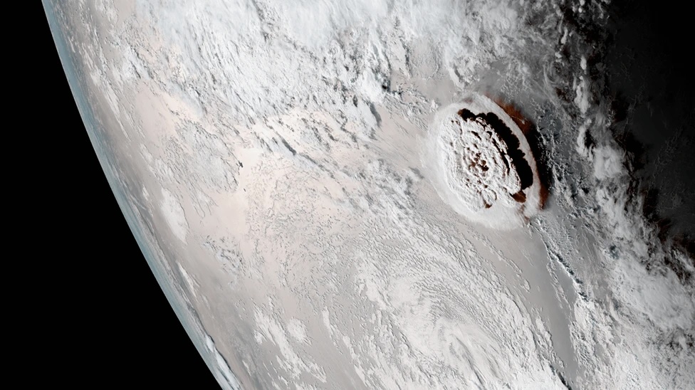
15 Jan 2022 made volcanic history, although it took days before we realized. The eruption of Hunga Tonga was the loudest bang since the famous Krakatoa explosion. The atmospheric pressure wave went around the world three times. A tsunami swept the shores of the Pacific ocean. The eruption changed the way we look at volcanic islands. But the only picture we have of the eruption itself are from space. Even in the 21st century, major eruptions can still occur away from human eyes. Source https://www.bbc.co.uk/news/world-australia-60027360
4 December

This was the island that could. In November 2013, a new island appeared next to Nishinoshima. Over the next year, the new island grew, merged with Nishinoshima itself and kept growing. The same had happened in 1974, but this time the event was much larger. The combined island became more than 10 times larger than the original. After a few quiet years, Nishinoshima erupted again in 2017 and in 2019. Carl called it the perfect volcano. Source: https://www.huffpost.com/entry/nishinoshima-island-japan-growth_n_6754420
5 December

This is the gentle giant of Africa. To quote Carl, any volcano looks better with an elephant in front. Kilimanjaro is the one volcano on everyone’s bucket list: climbing it is a rite of passage. It consists of three separate volcanoes. Even the youngest one has not erupted for 170,000 years, but is stil considered as dormant rather than extinct. There are world famous glaciers on top, which however do risk going extinct. There are parasitic cones on the slopes which may be a little younger. One of them is associated with Lake Chala, an ancient crater lake. Reports from the 19th century that there had been a historical eruption here are considered as unconfirmed.
6 December
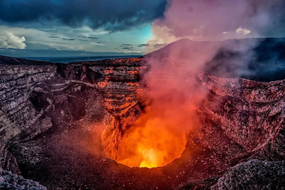
Volcan Masaya in Nicaragua is best known for its intermittent lava lake. The volcano is in reality a caldera within a volcanic complex. The caldera formed 2500 years ago. AT the bottom are a number of pit craters, and one of these, Santiago pit crater, on occasions contains lava, as it did in 2016 when Rene drew our attention to it. There are sometimes small explosions as well, most recently in 2003 with a 5km high plume.
Image source https://www.muchbetteradventures.com/magazine/volcano-hikes-ring-of-fire/
7 December

Kilauea is far from the tallest volcano of Hawai’i. But its eruption have been unsurpassed. They can occur anywhere along the two rifts or at the summit. The picture here was taken during the Maunaulu eruption, by J.B. Judd, October 11, 1969. The dome lava fountain is 20 meters high. The Maunaulu eruption lasted for five years, from 1969 to 1974. It was a tourist eruption: at one point people could look into the lava lake from a viewing platform. High fountaining and impressive lava flows during the first half year gave some of the best images of any eruption, including a famous one with lava falls taller than Niagara. Image source: USGS
8 December

In the spring of 2020, during the covid crisis, we at VC rescheduled an eruption (entirely tongue in cheek). It was a complete success. The build-up to what was to become the new Reykjanes fires ceased, and the first Fagradalsfjall eruption instead occured a year later, in early 2021. Iceland used the delay well. When the lava threatened to flow towards inhabited areas (roads), it was found that embankments could successfully divert the flows (at least on second attempt). This experience became invaluable during the follow-up fires. Now, both the town of Grindavik and the Svartsengi power station (including the Blue Lagoon) have been turned into polders, surrounded by lava tides held back by newly build embankments. Iceland has shown us that eruption mitigation and management is possible. We are awaiting the first university course in eruption engineering. Image source: https://www.icelandreview.com/news/met-office-preparing-to-declare-formal-end-of-eruption/
9 December

Volcano tourism is big business. Bit it can go disastrously wrong. On 9 December 2019, a group of tourist were visiting the crater of White Island, in the Bay of Plenty of New Zealand. The volcano had been stirring, but an eruption was not thought to be imminent. That was wrong. A sudden, large explosion occured. There were injuries and fatalities. It was the dark side of this type of tourism.
10 December

Japan considered it to be the most exquisite volcano in the world, and that says something for a nation that treasures Mount Fuji. Alaid volcano has a wonderful symmetric shape. It is located on (and in reality is) Atlasov island. The volcano changed ownership to Russia 80 years ago. It is the northernmost Kuril volcano, close to Kamchatka. The local folklore tells that it was exiled from Kamchatka when the other mountains became jealous of its beauty. Alaid erupts on average twice a decade. Its beauty derives from its frequent resurfacing. Most eruptions are VEI-2; the most recent VEI-4 was in 1981. Image source: wikimapia
11 December

Mount Spurr is the closest active volcano to motsfo Anchorage. The 3-km high mountain is deeply covered in ice and snow – it is perfect for extreme skiing (like bungee ironing but without the heat).There is a 5-km wide, 5,000 to 10,000 year old caldera, but more recent eruptions have been smaller, although still with pyroclastics and river floods. The most recent vent is Crater Peak, south of the summit. Mount Spurr has erupted twice in living memory, in 1953 and 1992, both causing ash fall in Anchorage. There was an earthquake swarm in 2004 and a cauldron grew at the summit but it did not lead to another eruption. But now the earthquakes are on the march again, the mountain is inflating and AVO has raised the alert level to yellow. Half the population of Alaska would be in view of an eruption. Image source: Alaska Volcano Observatory
12 December

This may be the wedding picture of the century. Taal is a well known, episodically erupting volcano in a large lake, surrounded by densely populated regions. It was part of VC’s new decadal list of dangerous volcanoes. After 43 years of dormancy, the volcano had a major eruption on 12 Jan 2020 with a 15-km high plume and volcanic lightning. 13,000 people were evacuated. The island, covered in thick ash, has been uninhabitable since. Image source: Warren Garcia
13 December

Etna is an underrated volcano on VC. There have even been false rumours spread here about a sicilian affair, doubting Etna’s very existence. Jesper corrected us on that when he described his walking tour around the summit. Etna is in fact the giant of Europe, not its tallest volcano (that is Elbruz) but by far the most active. Long before Star Trek, this was the original home of Vulcan, the god of the forge. There are five summit craters (as many as Olympus Mon) but eruptions can also occur on the flanks. These eruptions have at times destroyed villages, and in 1669 reached Catania where the lava was diverted by the city walls. Even the Etna Observatory was lost to lava in 1971.
Image source https://www.fernandofamiani.com
14 December

Mount Bagana is young. It first started around 400 years ago, as a new vent of the Billy Mitchell volcano on Bougainville, after Billy Mitchell had blown itself up around 1580. Over that time Bagana has grown to a height of 1850 meters, or 1 km above base level – this number may already be out of date! Bagana erupts a viscous andesite which has formed 50-meter-tall lava channels on its slopes, appearing like tall levees. Eruptions are frequent and at time near-continuous. In late 1943 until September 1945, the region was a battle zone between the Allied and Japanese forces. The name ‘Billy Mitchell’ probably comes from this time. At first landing in 1943, the Allied forces described the scene: Behind the curved sweep of the shore line, a heavy, dark green jungle…swept up over foothills and crumpled ridges to the cordillera which was crowned by a smoking volcano, Mount Baranga, 8,650 feet above sea level…It was wilder and more majestic scenery than anyone had yet witnessed in the South Pacific (Source: wikipedia). This wild child volcano is described in VC post. Image source: https://commons.und.edu/infantry-photos/57/
15 December

Calbuco, southern Chile, gave us one of the most photogenic eruptions of the century in April 2015. The VEI-4 eruption came after 40 years of quiescence. Calbuco’s eruptions come on average every few decades. The eruptions tend to be explosive. The 2015 eruption caused pyroclastic flows 7 km from the summit, and affected air travel as far as Brazil. Ash made local roads impassable. The first eruption in the morning of April 22 was captured in daylight with photos of the city in front of the ash column. The midnight eruption that followed, which was larger, gave rise to photos of volcanic lightning where friction between ash particles causes them to become charged, attracting lightning bolts. Image source: https://livetravelteach.com/chiles-calbuco-volcano-eruption/
16 December

Erta Ale, Ethiopia, is famous for its perpetual lava lake. The so-called ‘smoking mountain’ is located in the Afar depression, once of the most desolate, hostile deserts on Earth. The depression is caused by the nearby triple point where three plate are pulling apart, leaving the ground with too little support. As the ground thins and subsides, magma finds easy access to the surface: hence the lava lake in the crater of this shield volcano, which has been present since at least 1906. It can also erupt elsewhere: a 3-year long fissure eruption formed a 30 square kilometer lava flow. Erta Ale is by far the most active though not the tallest on a chain of shield volcanoes.
Image source: https://www.mostbeautifulspots.com/2016/03/15/erta-ale-volcano-ethiopia/
17 December

The Devil’s Tower in Wyoming shows us what lies below a volcanic surface. Nowadays a tall tower, 40 million years ago this was a lava lake or lava dome, situated inside a deep volcanic crater. It might have been akin to the deep lake at Halamaumau. Eventually, the heat went out and the lava, which was still sitting there, solidified. That may have taken decades or centuries. The frozen lake would have become buried under sediment and sand. But erosion cannot be denied. It broke down the sediment, sand and rock. But the solid lava was harder than the surrounding rock, and just like a volcanic plug, it ended up standing out, rising 250 meters above the diminished rock. It isn’t the work of the devil: just the work of time. Some things just last longer than others. This now gives us a view of the inside of an old lava lake or dome. As King said, judge not by the colour of the skin but by the content of the heart. Here lies the volcanic heart, clear for all to see. The columns that can be seen on the side of the tower are the sign of frozen lava: the six-sided shapes come from slow cooling and freezing of underground lava.
https://ui.adsabs.harvard.edu/abs/2011AGUFM.V33C2659Z/abstract
18 December

To quote Doctor Who, there is always a twist at the end. Volcanoes may not do much to the climate, they certainly can affect the weather. One aspect of this comes from the heat which causes the heated air to rapidly rise. A slight deflection to the airflow will twist the air, and a twister forms. This is the volcanic counterpart to dust devils. They were often seen on or near the lava fields of Iceland during the Reykjanes eruption. Once formed, they tended to meander and at times attack the nearest camera. The image from 2009 shows a lava ocean entry in Hawai’i. The rising plume of vapour above the hot layer of air just above the water triggers the formation of vapour devils. This spectacular picture has 6 of these, plus a 7th one trying to survive.
Image Source: Bruce Omori, https://uk.news.yahoo.com/incredible-photo-shows-hot-lava-155400167.html
Reykjanes can do this too. This video from July 2023 (Fagra episode 3) shows a large volcano twister which (about 4 minutes in) breaks up in a series of small twisters, circling one another. The dance of the 7 veils – with a twist.
https://vimeo.com/manage/videos/849756648
19 December

On 22 December 2018, Krakatau became famous for a second time. After the cataclysmic eruption in 1883, a new volcano appeared above the waves by the 1920’s, at the location where Verbeek had predicted it would regrow. The new mountain became one of the most active volcanoes in the world, where different from old Krakatoa which had several centuries between eruptions. By 2018 it was some 400 meters tall and its eruptions were spectacular to see. The photo was taken on 19 July 2018. But its demise was already in progress. The flank was beginning to give way. In December, the collapse came. It caused a tsunami. To everyone’s surprise, when the dust cleared, the entire volcano was missing. Not only the flank but the whole cone had slid into the sea. The collapse and tsunami had been predicted but the warnings had not been taken serious enough. And so a volcano was lost – again.
20 December

There is one thing that the story of advent and the story of Volcanocafe have in common. It is sheep. How a flying sheep came to be the emblem of this science blog was re-told by Carl in his decadal reminiscence, linked below. Of course flying sheep are not new. Richard Adams in The Plague Dogs tells us how sheep used to fly, until they put down their wings to graze and the wind blew the wings away. You can still sometimes see their wings high up in the sky but the sheep would never get them back. All sheep have looked sad ever since. It turns out that Icelandic storms are strong enough to lift up a sheep even without wings, although the landing was fatal.
21 December

The Cumbre Vieja eruption in La Palma in the autumn of 2021 showed the dangers of life in volcanic regions. It was a typical eruption for the region, and the time since the pervious eruption (50 years) was also typical. But the region had changed over that time and any eruption would be more damaging. The warning came on 11 September with an earthquake, and the eruption started a week later and the lava reached the sea by 28 September. In between the vents and the sea, like a wanderer between a bear and her cubs, was the town of Todoque; it was fully destroyed in the three-month eruption. The effective response by the authorities helped prevent this disaster from turning into a catastrophe.
Christian Nesset reported on a visit to the eruption: A volcano tourist at La Palma
22 December

Bardarbunga is the largest but also one of the best hidden volcanoes in Iceland. It came out of the shadows in 2014 when it send out magma far out through the rift zones. For over a week we followed the progress of the earthquakes, including the excitement whether it would turn north or south. In the end it went north, where the eruption started on 29 August. The Holuhraun eruption lasted for 6 months and erupted almost 1.5 km3 of lava. It was the largest Iceland eruption since Laki, and kept us glued to VC for days on end. It also showed us how long-distance rift eruptions work.
Source image: https://perlan.is/articles/holuhraun-volcano-iceland
23 December

Mount Nyiragongo in the Virunga mountains, Democratic Republic of Congo, is among the most dangerous volcanoes in the world. It prepares for decades by building up its deep lava lake, then lets go of it in a fast and furious event. The city of Goma lies in the firing line. After 20 years of waiting in the wings, it happened again in 2021. Lava went through new settlements near the city. Afterwards, as in every large eruption, people were on the move, searching for food and shelter amidst the devastation. It is easy to imagine how even a stable would be welcome.
Source image: The New York Times
24 December

Champagne pool brings us the ultimate volcano Christmas colours. Wai-o-tapu (‘sacred water’) on The North Island of New Zealand is a geothermal wonderland with a variety of brightly coloured geothermal pools. The colours clearly say ‘stay out’, ‘look – don’t touch’. Green comes from sulphur, yellow from arsenic, and orange from antimony. If that isn’t enough to argue against that dip, the water temperature reaches 70 C. A hot shower can be had at Lady Knox Geyser, right next door. In true Christmas spirit, the park’s website says that all major credit card are accepted. (They are, however, closed on Christmas day.) This is part of the Taupo Volcanic Zone. The geothermal field lies in the remains of the Rotorua caldera which formed some 200,000 years ago, making it 100 times older than advent. Hats off to New Zealand. Home of sheep, it is a proper place to end VC’s volcanic advent. Merry Christmas, everyone.


Oh, how nice. Can’t wait to see what else will make the list. Some Hawaiian lava show maybe? Or perhaps a bit of Indonesian ash? Surely the 13th should be celebrated with an Etnean paroxysm, since that day is Saint Lucy’s Day (Lucia), and she came from Syracuse, Sicily. Iceland deserves a few more spots on the list. I’m sure Eyjafjallajökull can clear the airspace from flights well in time for Christmas, so that Santa and his flying sleigh will not have to compete with any planes. Don’t worry, his sleigh is magical, so I’m sure it can resist the ash better than any airplane can.
A Great suprise advent show! Maybe some volcanoes will do a good eruption of the day. Yesterday (4 December) Stromboli did one with a small lava flow:
https://www.volcanodiscovery.com/volcanoes/today.html
Beautiful. Carl is so funny, a humour born out of intelligence. I miss him: “To quote Carl, any volcano looks better with an elephant in front.” What a great sentence.
Just got rocked big time from an M7.0 near the Mendocino Triple junction.
My place is about 140 miles away and the rolling motion lasted a good 30 seconds. Wind chimes, lamps and ceiling fans were all swaying for at least a minute longer.
This was a good’n.
Of note, is a 2nd triggered quake near Clear Lake (Cobb) happened less than 3 minutes later. Given the two quakes were around 175 miles apart, the 2nd (Cobb) earthquake was a totally different event (i.e. not an aftershock)…though the time spacing is strongly suggesting the Mendocino quake triggered the Cobb quake.
So far, social media is saying quite a bit of damage has occurred from both quakes, but details so far are very sketchy. Will pass on any important updates once more info rolls in.
Seems to be quite a bit of damage, but no fatalities:
Olivia Cobian, the innkeeper at the Gingerbread Mansion, a bed and breakfast in the historic town of Ferndale, said her 1895 building “looked like a war zone.”
“I have fireplaces flying forward.” she said. “Clawfoot tubs that have been lifted off [their mounts] and scooched over. This is crazy.
https://www.latimes.com/california/story/2024-12-05/earthquake-northern-california
Tectonically, the West Coast is a war zone between plates and faults.
USGS now reporting the Cobb quake was a false signal and has downgraded it to a mere M2.6…so it no longer poses any further threat.
Meanwhile, aftershocks of the M7.0 are continuing as expected, with aftershock pattern propagating towards/past the coastline.
With that section of the southern tip of the CSZ (which the MTJ forms the southern edge) and the Juan de Fuca having experience several major shocks in the last few decades, including a recent M6.1 off the coast of southern Oregon last month along the Juan de Fuca micro-plate, the CSZ is likely seeing increased loading from each event. Of note is this southern section of the CSZ is believed to be the most active segment of the CSZ and “probably” closest to failure…so when we see an M7 nearby, it’s hold your breath time hoping that the “big one” doesn’t let loose.
Point of clarification is the most southern tip of the Juan de Fuca is called the Gorda micro-plate which borders the MTJ. I often consider the Juan de Fuca as a single entity, but the Gorda has some characteristics that differentiates it from the Juan de Fuca just to the north.
Given subducting Gorda plate feeds Mts Shasta and Larsen, and is a strip of the Farallon, which ‘underplates’ all the way to mid-Nevada, before taking ‘long dive’, perhaps there is a ‘loose’ connection.
Nice write up from the USGS about the M7.0 MFZ quake today.
Note the history info which confirms what I said about the abundance of activity in a normally active region. At some point in time, the southern CFZ is going to let loose…likely sooner than later at this rate?
“Earthquakes are common in the region around the Mendocino triple junction. Oblique motion between the southern Juan de Fuca/Gorda plate and Pacific plate causes north-south compression within the Gorda plate and right-lateral translation along the boundary between the plates. The M 6.4 Ferndale earthquake occurred approximately 75 km to the east-northeast on December 20, 2022. A M 6.2 event occurred approximately 90 km east of the 2024 event, on December 20, 2021. In the past century, there have been at least 40 other earthquakes of M6 or larger, including five earthquakes M7 or larger, within 250 km of the December 5, 2024, earthquake. These prior earthquakes primarily occurred along the Mendocino transform fault, in the Cascadia subduction zone, or within the Juan de Fuca/Gorda plate”.
A window has opened
Nice one, thanks.
The Iceland eruption has begun to die slowly: https://en.vedur.is/about-imo/news/eruption-begins-on-the-sundhnukur-fissure-swarm
During the March-May eruption the final two weeks only erupted 1 cubic meter per second or less. The current eruption is likely of the same type, but a bit shorter. An eruption in the central part can erupt for longer time steadily than an eruption on the periphel parts of the fissure. It reminds to the relatively long and steady summit eruptions of Mauna Loa (last 1949) that are very different to the rift zone eruptions (1950-2022).
Today Kleifarvatn surprises with a ~5km deep earthquake swarm. Can the hydrothermal system there cause a phreatic/phreatomagmatic eruption?
I do hope the 2nd largest eruption of the 21st century is included! Seems to have largely been forgotten even though it was only 8 months ago.
Are we sure it was the second largest explosion? Cordon-Caulle comes to mind, as does Sheveluch, April 2023.
By volume then Holuhraun and Kilauea are 2nd and 3rd place, actually, if explosive they would be mid VEI 5, both well over 1 km3 DRE. And Kilauea actually is properly second, but because Pu’u O’o started before 2000 there might be technicalities. That being said post 2000 Kilauea has probably erupted nearly 4 km3 of lava and putting that as a tephra volume actually gets it close to Hunga Tonga Hunga Ha’apai.
There is also the big eruption under the ocean in the Comoros near Mayotte, which was probably a similar size to above or maybe even a bit bigger, not sure that is fully quantified yet.
Biggest problem with the VEI scale perfectly demonstrated.
Yes, Andy meant explosive eruptions. Effusive eruptions win hands down on volume – and we have had some impressive ones this century. But Hunga Tonga still would be the largest, I think. It was most impressive.
Yes, HTHH is still probably the biggest. It definitely is by total volume considering explosive eruptions like that are not direct magma = tephra volume, theres a lot of lithic fragments too.
I still do find it pretty interesting how much lava has actually been erupted relatively recently. Since 1960 Kilauea has erupted something like 6.5 km3 of lava by itself. And Tolbachik, Bardarbunga and Sierra Negra have all had major effusive eruptions of over 1 km3 in that interval too. Plus even more eruptions 0.1-1 km3, like Kilauea in 1960, Krafla fires, Mauna Loa in 1984 and 2022, Nyamuragira in 2012, Erta Ale in 2017, and now at Reykjanes ongoing. All of these would be VEI 4 or 5 if explosive.
There are some notable effusive eruptions before 1960, but apart from at Hekla in 1948 they are all from Mauna Loa that I can think of, and only one of those being comparable to any I mentioned before. Im sure I missed a lot but still.
I do remember a long time back I think it was Carl who said we were in a volcanic drought since 1991. Well now we have had Hunga Tonga, so I think it was certainly broken then at least, but I think maybe it was never real at all just more subtle. I mean, technically Pu’u O’o was a VEI 4 every year for almost 4 decades if you think about it 🙂
Not entirely sure on size tbh as I haven’t seen any accurate measurements yet, but it was initally estimated anywhere between 1.8 – 2.5km3 DRE.
Ruang is ranked larger than Shiveluch, Fukutoku-Okanoba, Taal, Ulawun, Wolf, Raikoke, Eyjafjallajokull etc. on GVP, actually 3rd in 21st century. It did also have a VEI4 in 2002.
I do think Cordon-Caulle was probably bigger. Estimated 2.7km3 DRE.
Thanks for those beautiful pictures.
Iceland and it’s people impress and always surprise. Here, devised a way to cool part of the main road which runs through geothermal heat. (Though it seems there might eventually be a worse problem.)
https://youtu.be/iz-YJdrTPo0?t=56
https://www-vedur-is.translate.goog/um-vi/frettir/eldgos-hafid-a-sundhnuksgigarodinni?_x_tr_sl=is&_x_tr_tl=en&_x_tr_hl=en-US&_x_tr_pto=wapp states that land rise has started again as the two active cones shut down
There is still some activity, but probably close to 1 cubic meter per second. If the eruption ends next week, it will have lasted for around 3 weeks, longer than the August-September eruption. It’s going to be the third largest eruption of the series until now.
Another window
Dukono did a 5.9 kilometers high vulcanian plume today:
https://www.volcanodiscovery.com/dukono/news/259419/Dukono-volcano-Halmahera-Indonesia-spectacular-explosion-this-morning-emissions-to-19000-ft.html
Valentin Troll presents his latest paper on the source of the lava in the ongoing reykanes events.
https://youtu.be/NFGB2dy4Xe0?si=dEflM-VGlVYH2ebt
Think Krýsuvík has some involvement, too. Would not like to say what but the volcano tectonic episode from late 2019 to present started near there.
The eastern shore of Kleifarvatn had recently many earthquakes. The hydrothermal system would probably react first if something magmatic moves in at great depth. Tourism website about the lake: https://guidetoiceland.is/connect-with-locals/asa1/snorkeling-in-a-geothermal-lake-in-iceland-kleifarvatn
Just remember that there were no hydrothermal precursors before eruptions at Fagradalsfjall or Sundhnúkur. It may happen that Krýsuvík is no different in that aspect.
Fagradalsfjall and Sundhnukur have no hydrothermal systems comparable to Krysuvik. Weak subterranean magmatic activity sometimes leads to hydrothermal events in Myrdalsfjökull and Vatnajökull. So I’d imagine that something like this should be possible at Kleifarvatn. How deep are the roots of Krysuvik’s hydrothermal system?
One issue that he does not touch upon, but I would like to see him comment upon, is the inflation near Svartsengi area, as apparently he infers that the underground magma is heading west, basically, from the large pool. The use of geochemistry is convincing as far as drawing some conclusions.
His paper found here – https://onlinelibrary.wiley.com/doi/pdf/10.1111/ter.12733
One more comment, Valentin Troll cites a paper on start of the magmatic inflation 2019 to Alex Hobe – the paper is found at https://www.diva-portal.org/smash/get/diva2:1690120/FULLTEXT01.pdf and a glance shows the importance of this doctoral dissertation in understanding what is going on in the Reykjanes Peninsula.
Kilauea last week of quakes. Its slowed down a bit just the last day but overall getting much more active, the next eruption is likely before new years.
Interesting but unlike basically all of the last 1.5 years there are actually a lot of quakes within the caldera. I still think an eruption near the September location is more likely right now but the summit could be in play too. Halemaumau is at 900 meters elevation, which is lower than pretty much all of the chain of craters, only Napau and Makaopuhi are significantly lower. So if not down there then in Halemaumau again.
It would be great if we could get another interferogram of the ERZ, the GPS shows it probably isnt inflating right now, but theres been nothing about it for a few months now. This one doesnt show the ERZ but is updated twice a month and shows the south caldera is uplifting again.
http://www.mounts-project.com/static/data_mounts/kilauea10/2024/kilauea10_20241123T161641_20241205T161640_VV_ifg.png
I do wonder at what point there really just wont be any more space underground anywhere, and the massive supply of magma can just flood out unobstructed again. It took 9 years for Kilauea to completely refill behind the 1975 ERZ slip, which at that time with 0.1 km3 yearly supply was a little less than 1 km3. 2018 was bigger, but supply now is too, and it has been close to 7 years. I do wonder if the next eruption we see start could still be going strong in 2060 🙂
Remember when the world went dark and Iceland had to postpone the Reykjanes fires? The new window is about what happened next.
huh?
See the picture for today in the post
Lewotobi with lots of tornillo earthquakes and harmonic tremor…What does that mean?
Also hasn’t erupted for week maybe…
Surprised that no one has mentioned Bárðarbunga yet. She got all shaky in the early hours of Sunday morning Iceland time.
Depth 3.9 km, with a fair number of shallower follow up tremors since. Nothing on the IMO or RÚV websites, but it is Sunday.
It was mentioned by IMO in the specialist remark:
“At 01:49 the 8th of December an earthquake of magnitude M5.1 occurred in the Bárðarbunga caldera. Events of similar magnitude are not uncommon in the area. The last earthquake of a similar magnitude was M5.4 on 21. April 2024. The event was not felt.”
It was not unexpected, since the number of smaller quakes have been increasing lately. In fact, I have been playing chicken with this one. I was going to drop a comment “watch out for incoming M5”, but I wanted to wait as long as possible. Thought about it on Saturday, but decided to wait a few more days. I guess I lost the game…
Bárðarbunga has been really noisy this year. 4 quakes of magnitude around M5 or above. Similar to the activity in the 1970s. I don’t think it’s ready for another Holuhraun, but when pushing a plug up like this, there’s always the possibility that a cone sheet can form that might reach the surface. That would give a small eruption from the rim, potentially breaching the ice cap, but nothing significant. If that happens, you can expect a swarm of small aftershocks that would intensify for a few hours or days. Very similar to the seismicity that was observed before the Gjálp eruption in 1996.
“4 quakes of magnitude around M5 or above.”
That’s a lot for one year. Most trapdoor volcanoes need multiple years to throw one of these.
Yes, it’s impressive. Looking at the quake sequence from the 1970s and all the way up to the 1996 quake is equally impressive.
https://jokull.jorfi.is/articles/jokull2014.64/jokull2014.64.061.pdf
How often does Bardarbunga eruptions on the SW fissure swarm (Veidivötn) towards Torfajökull? Is this impossible after Holohraun now or are there individual magma chambers?
I’m guessing the caldera floor will have to rise again to similar levels as before Holuhraun before a Veidivötn eruption can happen since it’s a trapdoor/piston volcano.
Historically there was 1477 and 877. Before that was in around 200 or something like that. So Veidivotn rifts maybe 500-700 years apart. But in that time there was also rifting in 932 and 1783, obviously, and there was also a significant rift northeast of Hekla in around 700. So rifting intervals of this boundary as a whole are 6 in 2000 years, 330 years separated but in reality 3 of them were within that span of each other entirely, so its obviously pretty variable. But its been 242 years since Laki so its not unlikely the next rift is before 2100.
There was a rift southwest in 1862 but that maybe isnt really the same as a full Veidivotn eruption, although the difference is kind of arbitrary. If so that makes 7 events at 285 years apart, but also only 161 years since, so much less likely to see a big rift soon.
This is only for the southwest plate boundary, that gets called the ‘dead zone’ here. Supposedly because it is too hot to quake, but I think it actually just isnt very active excepting major movements. Laki had huge quakes as precursors as the dike broke the crust apart.
Veidivötn is not far away from Laki, only ~10km apart. They show well the general distance between Bardarbunga and Grimsvötn. Both fissures continue below the Vatna-glacier. Veidivötn was 877 and 1477, Laki 1783 and in the northern part of Bardarbunga Holohraun 2014-15. During Holocene Grimsvötn only did four eruptions in Laki, while Bardarbunga did 22.
So we can’t expect an extraordinary effusive eruption in this area during our lives. Maybe an alternative Icelandic volcano will do it.
They are close, but start at different volcanoes. At the moment none of the obvious ones are ready to go. Grimsvotn itself probably doesnt directly feed Laki the same as Bardarbunga to its rifts, its caldera is too small for the volume. And Grimsvotn also isnt completely dead for the next millennium… Laki probably came from magma accumulating in the middle or lower crust at the source for Grimsvotn and Thordarhyna. The same might be true for Eldgja but Katlas caldera is big enough to explain it. Veidivotn eruptions might come from Hamarinn as much as Bardarbunga, so possibly Holuhraun isnt as conseeqential. And Torfajokull does seem to actually erupt for real, not just passively,, and maybe it doesnt really matter how much magma is in the volcanoes if its been long enough to see the plates diverge. So the chance is reasonable to get a rift somewhere in the area this century, but it was probably a lot higher before 2014 to be fair.
I will add that Hekla actually does have a hand in this area. Not like the big calderas, but its rift zone does go inland up to the rjver. It did rift in 1913 but small, but Hekla itself had been pretty quiet. There was a lava flood of 1 km3 as well as a series of explosion craters showing not all eruptions are small here. Also some big and very long lava flows at Vatnafjoll next to Hekla, look like the eruption barely lasted a few days and sent the flow out like a flasf flood before dying back and making a cinder cone. Like Svartsengi but bigger and more strombolian, probably more volatile magma.
Given Hekla was unusually active recently, and Torfajokull was inflating and might still be, it seems this part of Iceland is very productive right now. It is also the bend in the plate boundary turning to a transform fault, and at the other end in the Reykjanes volcanoes which are obviously very active now. So maybe we shouldnt assume Vatnajokull controls the dead zone, it might well be forced apart from the other end, and then all timelines based on Bardarbunga and Holuhraun and Grimsvotn are now irrelevant 🙂
A curious aftershock pattern has emerged following the M7.0 MTJ jolt…as in the absence of even moderate aftershocks. Despite 100’s of small shocks extending along the Mendocino fault line towards the Petrolia area (which experienced in 1992 the trifecta of M7.2 (thrust fault), M6.6 and M6.4 shocks), there has been but one aftershock >M4.5 (i.e M4.7). I find this very curious for a California transform quake. Usually there is a robust aftershock sequence following the bigger earthquakes with a couple having magnitudes only a point or two weaker than the mainshock…so one must wonder why there hasn’t been any this time? My best guess is the MTJ fault zone in this area has a very finite amount of stiction, and in reality is a jumble of fractured crustal segments that all released at the same time. It may also be that there is a residual stress-relief shadow following the Petrolia quakes (east of the mainshock)..which may explain why the current aftershock sequence from the off-shore M7.0 has been strongly directed towards where the Petrolia quakes originated…in essence, the M7.0 could just be the next in a series of connected fault failures along the MFZ. Given that the ESE terminus of the aftershocks is along the far northern tip of the San Andreas, I sure hope the northern segment didn’t get too loaded.
How long was the segment that failed?
About 30km according to the finite fault model. The maximum slip was about 15km east of the hypocenter. The quake unzipped due east along the Mendo Fault Zone, with the aftershocks closely following the MFZ then then down a small section of the San Andreas. Almost nothing in the way of aftershocks to the west of the hypocenter. In this regard, nothing really unusual except as noted, a definite dearth of strong aftershocks.
Some interesting ‘small stuff’ on the transverse fault next-north.
The few inland of Mendocino may just be ‘background noise’…
As you say, the Mendocino Fault seems to be settling ‘piecemeal’,
Lots of ‘iggling and wriggling’.
Scary for locals, a joy for geologists, better than ‘ensemble’ all letting go at once…
I’m not sure what happened with that one; I’ve seen a finite fault solution that looks simple, and a source-time function that suggests a complex rupture. Go figure!
True and not surprising. The eastern extension of the MFZ (RL transform) transitions to oblique and thrust faulting as it makes it’s turn to the SE then S before becoming the San Andreas..so they are actually part of the same “edge” of the Pacific plate. What this aftershock pattern is suggesting is the relative motion/pressure from the Pacific plate is the main source of pressure that’s getting relieved at the MTJ..i.e both thrust/oblique around the bend and transform faulting on either end.
With the Pacific plate moving S-N and then E-W along the MFZ, plus the W-E push of the Gorda Plate, think of an elephant (the Pacific Plate) balancing on a nail: all the pressure (weight) gets concentrated to a small area. If the nail is on rock, the nail bends and folds (i.e. the Klamath and Trinity mountains). If the nail is in sand, it moves more easily (transform)…all a matter of varying stiction and resistance.
IMHO, this is why the quake was probably so complex as it indicated a multitude of movements/stiction given the bends in the San Andreas/MFZ were involved.
As a side note; if this activity spike (~last 50yrs) along the MTJ is indeed being largely driven by the relative motion of the Pacific plate, then the same stress must getting applied to both the entire San Andreas and MFZ west of this 7.0 hypocenter. With the far northern segment of the SA being strongly locked and almost entirely aseismic since 1906, every jolt along the nearby MTJ is a reminder of ever-increasing stress that continues to get stored along the SA. Would be really interesting to see what the cumulative seismic moment has been in the last 50yrs of activity around the MTJ? Think of a stalled train pushing on a pile of logs on the tracks. The train keeps pushing, and one by one the logs get pushed aside. Eventually the train wins out and it lurches forward until it runs into another pile of logs and the process repeats. With each MTJ jolt, one more log gets removed ahead of the SA freight train.
The next window
Dec 9
Volcano tourism is big business. Bit it can go disastrously wrong. On 9 December 2019, a group of tourist were visiting the crater of White Island, in the Bay of Plenty of New Zealand. The volcano had been stirring, but an eruption was not thought to be imminent. That was wrong. A sudden, large explosion occured. There were injuries and fatalities. It was the dark side of this type of tourism.
Tomorrow: is this the most beautiful volcano in the world?
A small island as indicator for bigger volcanism on New Zealand … and reminds to the danger of small phreato-eruptions if humans are too many nearby. Small eruptions are more difficult to predict than big ones. It reminds to the risks of Auckland’s volcano field.
Over on spaceweather.com, ( https://spaceweather.com/ ) there is an interesting article regarding how agriculture/farming machines that rely heavily on GPS for auto-tracking got impacted by the aurora outbreaks earlier this year. No wonder geologic data that also relies on GPS was all over the place for quite a while.
Something to file away when sharp unexplained spikes in GPS data is observed. Like wind and weather affecting tremor/seismographs, the Sun has to be checked for any disturbances that could be affecting the GPS readings.
I assume these were single-frequency GPS systems? There are more accurate systems available. They are more expensive but would be better able to cope with ionosphere fluctuations. The top end uses a ground station on the farm, and measures locations relative to that.
Thanks. Didn’t know about the alternative systems.
Would you know if these type of advanced GPS stations are utilized on simple ground sensors?
I don’t know the details. They are called RTK systems
Hatches and dispatches.
Evacuations underway as Philippine volcano erupts (Phys.org, 9 Dec)
Seventh eruption in Sundhnúksgígar comes to an end (RÚV, 9 Dec)
We await the next episode in this volcanic soap opera!
Nice video from Philippines media of Kanlaon starting to erupt:
Dec 10
Japan considered it to be the most exquisite volcano in the world, and that says something for a nation that treasures Mount Fuji. Alaid volcano has a wonderful symmetric shape. It is located on (and in reality is) Atlasov island. The volcano changed ownership to Russia 80 years ago. It is the northernmost Kuril volcano, close to Kamchatka. The local folklore tells that it was exiled from Kamchatka when the other mountains became jealous of its beauty. Alaid erupts on average twice a decade. Its beauty derives from its frequent resurfacing. Most eruptions are VEI-2; the most recent VEI-4 was in 1981. Image source: wikimapia
What would you consider your most beautiful volcano?
Hard to beat Karymsky.
Hard to choose, but Mayon deserves a mention here.
Standing before the vast pit of Kilaueas caldera, filled with glowing lava, and then behind it Mauna Loa that looked more like an immense void in the stars than a sillouetted mountain. Im not sure about beautiful but definitely awe inspiring.
I am jealous now.
I am jealous of all those who see the Maunas in clear daylight, only through the opposite window for a few seconds before landing. Hilo was under a cloud blanket, and Puna is too far away to really see.
I am also a little jealous I went 8 months too early to see it erupt, although it seems even HVO wasnt fully convinced it was ready until basically when it happened, so just luck I guess. Theres a painting made in 1880 from Kilauea looking at Mauna Loa showing them both erupting, and someone (forget who at this moment) recreated that view almost perfectly in 2022 🙂
Not actually the video I was thinking of, but much better 🙂
https://youtu.be/5ZcNeS7TlCg?si=YW7SWtr9Ke6eY3KU
This is the painting. By Charles Furneaux in November 1880. There really is something Mordorean about it.
https://encrypted-tbn0.gstatic.com/images?q=tbn:ANd9GcSB6BUbjlmnfn8hQaiLfhVKKeLAR2NftIgFEC5HyoSDcMRvZ5c6TkQmW8Q&s=10
https://www.facebook.com/share/p/1BPqfTZbPp/
Don’t know about “most”, but I’ve always thought Mount McLoughlin in southern Oregon is exceedingly pretty, especially when it has that Fuji-like snow cap over lower elevation forests.
Etna, of course! ♥
Herdubreid!
Other pretty ones are Cotopaxi or Tengger Caldera / Bromo, Viti crater at Askja, etc etc
Mt Cleveland in Alaska is one of my favorites
Parinacota.
There are several perfect A-shaped mountains from Japan to Alaska (f.e. Shishaldin). Did they form a similar way by a series of small to moderate explosive eruptions?
Volcanoes like these are opposite to St. Helens or Novarupta that collapse the mountain by an eruption.
Actually, St Helens was known as the Mount Fuji of the US before the collapse.
St. Helens profited from changing magma composition. The cork which prohibited a vertical eruption 1980 was built of Andesitic magma. I guess that Andesitic magma enables the creation of A-shaped mountains. They don’t do Kamikaze eruptions, but keep their peak during the eruption. The Andes volcanoes have some A-shaped peaks, f.e. Sangay
https://www.google.com/search?sca_esv=08af81acf73058fc&q=sangay+volcano&udm=2&fbs=AEQNm0A6bwEop21ehxKWq5cj-cHa02QUie7apaStVTrDAEoT1GiVzOBBcEbsoZQwi7osVtOAu-MBZrqB4PGUD44lSBFPwloritJkNL_YjZWhCxHZl_Sa-IqLtTC7F1Sfq1GFDOSrmBfaW_EMZd3drAIsOInZU_UHw2JmzJU6mBXLX0ojaSr_JzU&sa=X&ved=2ahUKEwit-8Cg252KAxXVg_0HHZUuDlcQtKgLegQIExAB&biw=1893&bih=952&dpr=1.01
It was like Merapi now. Doesnt erupt really big, just slowly and pretty much constantly. Although VEI 4s can happen at such volcanoes.
Merapi is actually rechnically a rhyolitic or rhyodacitic volcano though, the magma is that evolved but full of mafic crystals to the point its average composition is a basaltic andesite, but it is really a crystal rich felsic magma. Most andesites are like this I think, felsic melt with a lot of mafic crystals, actual true andesitic melt is much more fluid and doesnt form domes, like we see at Kilauea in 2018, or at Hekla. I remember seeing this whole topic discussed here a while ago and St Helens was mentioned so I expect it is similar.
I guess its like how water is very liquid but mud can be viscous even though it is mostly water still.
St Helens is probably complex to understand with the big variety of magmas from basalt do dacite and back. The Cascade Volcanoes have some basaltic magmas with shield volcanoes (https://www.usgs.gov/publications/paleomagnetically-defined-brief-lifespans-two-large-shield-volcanoes-cascades-arc), but also some more viscous types of volcanism. Maybe St. Helens changes between both types from time to time including phases with Andesite.
Will start to work on one of my volcano tourist memorirs as an article
Will be a fun one hopes albert will accept it: I will first process the more than decade old photos
I think Albert will like this one whats the maximum word lenght? first I needs to work on the photos
over 6000 words and we will cut it to bits..
Episode 7 (“The Force Awakens” in Star Wars) of Grindavik’s eruptions has ended. It lasted for 18 days. It was the second largest 2D (square kilometers) eruption in the series.
The eruptions started on December 18th last year. So we’ve had one year with seven eruptions in Iceland! In the past we had to wait for years for an Icelandic eruption. Usually (2000-2014) I made the experience that an eruption happened when the last one was long forgotten. This applies f.e. for Eyyjafjalla’s eruption 2010 or the Grimsvötn eruption 2004. Four or six years waiting time for next eruption is very long for humans. The first two decades of 21st century had each two eruptions, if we exclude 2000 with Hekla:
– 2004 Grimsvötn, 2010 Eyyja
– 2011 Grimsvötn, 2014-15 Bardarbunga
So 2001-2020 the average time of five years between eruptions was confirmed. Two eruptions were very dense behind each other (Eyyja and Grimsvötn), while after 2004 it was a long timespan of six years.
1996 to 2015 Iceland needed 20 years to do seven eruptions.
Krafla did seven eruptions in six years (1975-1981). It was a more calm eruption series, but had more deformation and probably more intrusions.
That Lewotobi eruption has been spectacular but Kanlaon is about to overtake it.
This Advent calendar is a good idea but wouldn’t it also be fun to have a bracketed competition for volcano or eruption of the year?
Wouldn’t be surprised, it’s been restless for a long time now…
I haven’t noticed a classical Plinian eruption during this year. Sometimes big ash plumes, but they looked rather Vulcanian to Sub-Plinian.
Ruang should count as one
Great fun – but a bit too early yet? Or we could have a competition for what will be the eruption of next year. I predict Askja
Albert, can you specify a bit more what you are looking for? The https://www.volcanodiscovery.com/volcanoes/today.html shows lots of erupting volcanoes, I counted 44 a couple of days ago. Their webpage https://www.volcanodiscovery.com/volcano/news.html has an interactive map showing active volcanoes.
Which volcano do you expect will be the best of 2025? Crystal ball viewing
Vesuvius
Outside chance: Campi Flegrei
It’s still steadily inflating, and if it erupts another cinder cone you will have a lot of very excited media coverage!
I think next year Kilauea will create Pu’u O’o #2, maybe not as visually imposing as a plinian eruption but if we get a decade of lava geysering to watch that is fine by me.
Next year I also think one of the big Icelandic calderas will erupt, though im not going to pick one in particular,
3rd is Dukono, its had some bigger bangs than usual recently, and it is a huge volcano with a big magma chamber to hold an open vent for 90 years. Also might be both a rifting volcano and probably a massive caldera progenitor. Its probably nothing but there are always wildcards.
The most probable volcanoes are not the best ones. The best eruption will be a surprise eruption, because it has to be prepared over long time. Did anyone expect Pinatubo or St. Helens one year before the eruption?
Maybe not the best, but a paroxysm from Villarica would be impressive and not super-unlikely considering recent unrest and the time elapsed since last, although still unlikely. Kilauea likely will do a decent eruption and obviously Sundhnukur.
Alaska has for a while not done a big eruption, it would be a possible choice for a surprise Plinian eruption.
Searching / seeking for lava eruptions, Kilauea is probably the best bet. But the continuiung development of Reykjanes is uncertain. A risk for more severe eruptions remains there. East African volcanoes may also do something impressive, but unfortunately often in civil uncertain regions.
I suspect something in that area..if not Askja then Bárðarbunga. Far be it from Iceland not to leave all of us with jaws agape and have some other long dormant volcano rumble awake.
I’m also over here cheering on Spurr. Alaska has been suspiciously quiet all over.
Dec 11
Mount Spurr is the closest active volcano to
motsfoAnchorage. The 3-km high mountain is deeply covered in ice and snow – it is perfect for extreme skiing (like bungee ironing (see https://en.wikipedia.org/wiki/Extreme_ironing) but without the heat).There is a 5-km wide, 5,000 to 10,000 year old caldera, but more recent eruptions have been smaller, although still with pyroclastics and river floods. The most recent vent is Crater Peak, south of the summit. Mount Spurr has erupted twice in living memory, in 1953 and 1992, both causing ash fall in Anchorage. There was an earthquake swarm in 2004 and a cauldron grew at the summit but it did not leads to another eruption. But now the earthquakes are on the march again, the mountain is inflating and AVO has raised the alert level to yellow. Half the population of Alaska would be in view of an eruption. Image source: Alaska Volcano ObservatoryNot to nitpick but shouldn’t that be Mount Spurr (double r)? Just a lurker, but I really enjoy the articles here, and this one is particularly fun.
You are welcome! And completely right – the error has now been fixed. (It is normally the Icelandic volcanoes rather than the US ones that causes these problems!) Thanks for pointing this out.
Dec 12
This may be the wedding picture of the century. Taal is a well known, episodically erupting volcano in a large lake, surrounded by densely populated regions. It was part of VC’s new decadal list of dangerous volcanoes. After 43 years of dormancy, the volcano had a major eruption on 12 Jan 2020 with a 15-km high plume and volcanic lightning. 13,000 people were evacuated. The island, covered in thick ash, has been uninhabitable since.
http://www.volcanocafe.org/the-tiger-in-the-smoke-taal-the-new-decade-volcano-program-8/
Taal was an experience, good fortune that the dike couldn’t get more magma out of it, it could’ve been far worse.
Taal sound like the town Dale (“Thal” in German translation) in the Hobbit fairytale that was destroyed by the dragon Smaug and played a role in the reconquest of the Lonely Mountain.
Dale means Valley, or Vale, same as Dalur in Icelandic. Must be an old Germanic word. Tolkien was very good with languages obviously and the part of Middle Earth that his books actually give detail on is meant to be basically Europe, so this isnt surprising.
Taal means ‘pure’ or ‘true’ in the Batangueño dialect of Tagalog, although Wikipedia also immediately before that says the lake was named after the Pansipit river, which was called Taal-an, and was named after the Taal-an tree that grew along it. But basically Taal doesnt mean anything in English other than just the name for the lake and volcano.
Maps of Middle Earth do show Mordor as a ring of mountains, though… Kind of like Taal but mostly dry, so Mordor might be a caldera if interpreted literally. I doubt that was ever considered in the lore though. But assuming west Middle Earth is as big as Europe, then Mordor is as big as the whole of the Black sea, or 40% bigger than Iceland. So if it is a single caldera it is something truely fitting of fantasy, Toba is 100x smaller. Might even be capable of a VEI 10 at that point. Also that Frodo and Sam basically walked from England to the Balkans, which is where Mt Doom is on this map…
I think the movies significantly downsized everything for visual effect…
It’s my birthday! And I demand a birthday present! Anyone ready to humor me? (It shan’t cost a dime…)
Our present to you is the right to publish a post in VC at no charge!
I was hoping to send the cafe an Inquiry about my oft-mentioned volcanic spouse. I’ll stick to my word about not writing another post about CCN until something major happens but there’s been an interesting development at the volcano
Some new Insar data dropped to show the last two years of inflation at the volcano. I am a bit confused. The Area of uplift at the volcano has not only grown but homogenized. The 2 deformation halos have merged, and now all of Potrerillos, Chalpatan, and CCN (over 350 km2) are rising +2 cm/year. The fastest rates are 4-6 cm/year. I don’t know whether the Dike or magma chamber is responsible. No reports from the IGEPN all year. Thoughts anyone?
my main thought is that 2cm x 350km2 is a lot 7+e6 m3 I think
AKA enough to fuel a high-end VEI ………. 2.
That figure is too low, Back in 2019, with a smaller and less intense deformation field, the intrusion was calculated to be 8-10+e6 m3/yr. The most interesting thing is that areas that were under subsidence before are now going through uplift
https://insarmaps.miami.edu/start/0.6893/-77.7391/10.0658?flyToDatasetCenter=false&startDataset=S1_IW23_142_0590_0593_20150107_XXXXXXXX_N00575_N00966_W078130_W077701&pointLat=0.66437&pointLon=-77.86571&minScale=-3&maxScale=3&startDate=20230203&endDate=20241114
With volcanoes in thick crust that erupt very rarely, it might not really be possibly to predict eruption by supply rate. We know its been millennia since an eruption but maybe not millennia since last time it did what we see now, well maybe on this scale but not in total. And just the act of getting through an orogenic belt means there is going to be immense magma storage under even the smallest sign of volcanism. So big changes dont necessarily mean a big bang.
CCN seems to be a volcano like Bagana or Santiaguito, a lava dome that grows big enough to kind of become a stratovolcano. So probably not dangerous mostly. But of course Santiaguito formed out of a VEI 6 eruption 20 years earlier, if there is a risk it will probably be at the very start.
Not only is the crust thick but it’s also elastic so that make eruptions even harder. I am going to go out on a limb say that CCN is just a subfeature of the larger system. Before only portions of Potrerillos and Chalpatan were going through uplift but now both volcanoes and some areas beyond are also rising.
My brain have kind of half stopped working smoothly again due to cloudy weather and the very low light winter conditions here, I lives very far north indeed if my latitude was put in Canada my home woud be as far north as the northen arctic part just below the arctic canadian islands there. I guess that Scandinavian are the worlds most northen large developed cities alot farther north than most other …. months of subarctic winter stinks
It makes me really miss the Big Island of Hawaii and its magnificent volcanoes so I should write an article about my lava visits there
Superb Taal photo!
Re your Dec 9 volcano the Kiwis have another activity report up:
Larger steam and gas plumes visible at Whakaari. Volcanic Alert Level remains at Level 2 and Aviation Colour Code at Yellow (12 Dec)
Whakaari / White Island is currently emitting larger steam and gas plumes, but no ash has been detected. The Volcanic Alert Level remains at 2 and the Aviation Colour Code at Yellow.
Just reminding us that she is there, in case we forgot her.
Oops stuffed up the block quote. Sorry. The top link works though.
Friday, Dec 13
Etna is an underrated volcano on VC. There have even been (https://www.volcanocafe.org/the-sicilian-affair/) false rumours spread here about a sicilian affair, doubting Etna’s very existence. Jesper corrected us on that when he described his (https://www.volcanocafe.org/summiting-etna-the-gate-of-hell/) walking tour around the summit. Etna is in fact the giant of Europe, not its tallest volcano (that is Elbruz) but by far the most active. Long before Star Trek, this was the original home of Vulcan, the god of the forge. There are five summit craters (as many as Olympus Mon) but eruptions can also occur on the flanks. These eruptions have at times destroyed villages, and in 1669 reached Catania where the lava was diverted by the city walls. Even the Etna Observatory was lost to lava in 1971.
Image source https://www.fernandofamiani.com
Dont forget Io where one single volcano maybe 100 000s if not many millions of times Etnas thermal output flux during low level activity in voragine : ) I wants a spaceprobe to Pele Patera
Sorry, could not do Io today. Tomas had demanded that Friday the 13th was given to Etna. We may never know why..
Here’s why:
https://en.wikipedia.org/wiki/Saint_Lucy%27s_Day
In Sweden we celebrate this day in a traditional and very peculiar way. Why protestant Sweden celebrate a catholic saint from Syracuse remains a mystery, but in our celebrations she represents a bearer of light, which is very welcome in the deep darkness of the Swedish winter.
Here’s an example of a Swedish celebration in a more professional (and televised) version. The procession with Lucia dressed in white wearing a crown of lights is the essence of the celebration and can be seen performed throughout Sweden by everything from pre-school kids to professional singers.
https://www.youtube.com/watch?v=wcCnso0PcAs
With Lucia, or Saint Lucy, being from Syracuse, I found it very appropriate to let Etna represent the 13th.
I don’t see why, given that Etna is roughly 7500km from Syracuse.
I’m also a bit puzzled that a Catholic saint hails from New York, which, like most of the original thirteen states, I’ve been given to understand has been a Protestant stronghold from its inception.
Not taking the bait 😂
Happy holidays!
Here is NASA’s gift for the Io-phile:
and a link to yesterday’s article with the full content regarding Io’s volcanism:
https://www.nasa.gov/missions/juno/nasas-juno-mission-uncovers-heart-of-jovian-moons-volcanic-rage/
Ooh, I missed it during my first reading, but it’s fun to watch:
https://www.youtube.com/watch?v=Zpc_LCQD0hc&list=PLKWlaxzCh8uLBy_Wfe_vPfTTV_p1yWxQo&t=84s
NASA created an animated flyby and dissection of Io, showing their latest ideas of Io’s volcanism.
♥ Etna ♥
Laughing!
Why? She is gorgeous! 🙂
That she is….and I love that photograph. I hear it won tons of awards.
Also it is proof that just because she’s a lady doesn’t mean she can’t throw shade.
One must be careful when saying “advent” around Etna….or she will sprout a new orifice and some creative individual will give it a highly imaginative name like The Newest New Newie McNewface Crater.
The earthquake series in Snæfellsnes system continues, today with quakes at around 16 km depth. The earthquake map https://skjalftalisa.vedur.is/#/page/map shows well the concentration of earthquakes in the highland area. Until now they remained at approx. that depth.
Maybe this will be the area of an effusive surprise eruption 2025? In case of an eruption lava will probably flow through river beds of the valleys like some eruptions in Oahu (Hawaii) did. An eruption there would include an explosive phreatomagmatic part.
Could be a lot of years away yet but definitely a future place of eruption. The fissure at Grabrok was only 3000 years ago, and Berserkjahraun (what a name!) was around 4000 years ago. Also look out for some slightly evolved magma if/when it does ago, as previous eruptions have hinted at intermediate storage in multiple chambers/sills.
On a different but foundation topic, of what science really is, please consider this paper https://link.springer.com/article/10.1007/s10699-004-5922-1 where author Sven Ove Hansson finds scant evidence for scientists following Dr Karl Popper’s “scientific” philosophy.
He writes about the 70 articles contributed to Nature (considered one of the true science publications) in 2000:
“Only one of these articles conformed to the falsificationist recipe for successful science, namely the falsification of a hypothesis that is more accessible to falsification than to verification. It is argued that falsificationism relies on an incorrect view of the nature of scientific inquiry and that it is, therefore, not a tenable research methodology.”
While I personally would like more explanation on the last sentence (claim) I am posting this because we cannot just assume the Popperian view is “true science” when examining the facts shows otherwise. I hope Volcano Cafe readers take notice.
– Randall
p.s. I find that once again the $$$$ paywalls are hiding pertinent information. Who has decided that the average person has to shell out $$$$ to even learn about science?
It gets worse. For most publications, you even have to pay a fee to submit a scientific article. When I was publishing, it was typically around 60 US Dollars and there was no guarantee it would be accepted. It would then be reviewed by a number of so-called peers who may or may not have any idea of the subject. At least one of the peers would offer ridiculous advice and ask stupid questions. One of our papers drew the comment that it would benefit from a review by an English speaker. Basically, it was in UK English and the reviewer was from the US, but wasn’t astute enough to recognise that fact. I hold to my written English, despite my strong west country dialect.
The general advice is that, if a paper is behind a paywall, don’t pay. That is actually quite important. The fee is there to stop you reading it, and to ask your library to get a subscription (which is how the journals make their money). If people start paying, they will raise the fee until they stop.
Try to find a free version of the paper, using sites such as Researchgate where authors can deposit their papers. If no free version exists, forget about the paper – ignore and don’t cite. If the authors are that desperate for you not to read their work, it is probably not worth reading.
Most research funders now require papers to be open access. Geology is one area where people (for unfathomable reasons) are still reluctant to to do this.
There is also Alexandra Elbakyan and her sci-hub… Keeps on changing its domain, now at https://www.sci-hub.wf/
Some-times, some-times, you can find a PDF pre-print on eg Arxiv etc.
Sadly, too rare.
And exasperates when eg Phys.Org kindly references journal article, but does *not* mention if pay-walled…
The NASA Firms/Lance satellite shows that Heard Island Volcano near the Antarctic is active the past 24 hours. See https://ibb.co/N3dsVD8 and also https://firms.modaps.eosdis.nasa.gov/map/#d:24hrs;@-284.4,-51.8,7.3z
Dec 14
Mount Bagana is young. It first started around 400 years ago, as a new vent of the Billy Mitchell volcano on Bougainville, after Billy Mitchell had blown itself up around 1580. Over that time Bagana has grown to a height of 1850 meters, or 1 km above base level – this number may already be out of date! Bagana erupts a viscous andesite which has formed 50-meter-tall lava channels on its slopes, appearing like tall levees. Eruptions are frequent and at time near-continuous. In late 1943 until September 1945, the region was a battle zone between the Allied and Japanese forces. The name ‘Billy Mitchell’ probably comes from this time. At first landing in 1943, the Allied forces described the scene: Behind the curved sweep of the shore line, a heavy, dark green jungle…swept up over foothills and crumpled ridges to the cordillera which was crowned by a smoking volcano, Mount Baranga, 8,650 feet above sea level…It was wilder and more majestic scenery than anyone had yet witnessed in the South Pacific (Source: wikipedia). This wild child volcano is described in https://www.volcanocafe.org/bagana-child-volcano/. Image source: https://commons.und.edu/infantry-photos/57/
https://youtu.be/xsyYAhSWeaM?si=OMA4HSO2Fd8ETKiA
Video from Geologyhub about Santiaguito. I have for a while wondered if it is evolving to a stratovolcano, it looks like one visually now, and old Santa Maria doesnt have any viscous looking lava flows around it.
Also does seem to infer that this volcano wont be stopping any time soon. I wonder if similar composition evolution has occurred at other persistent lava dome volcanoes, like Bezymianny and Shevluch, I know he did hypothesize it for Popocatepetl when it was really active a while back but nothing followed up.
It is basically just a somma volcano isn’t it, the volcano is really still Santa Maria
Kilauea might do a summit eruption next it seems, not what I expected. Also been a bit unpredictable, flaring up with quakes then dropping to basically nothing for days, but the tiny quakes showing on this map only display during time of unrest so there is something going on.
The UWE tiltmeter shot 3 microradians in a little over a day so that must have shaken things quite a bit at the summit. Both earthquakes and deformation have slowed down now. Kilauea is very fickle, it repeatedly changes from strong deformation and earthquake crises to quiet. It’s also usual that the focus of activity shifts, for example now we have the summit swarming but the next crisis could very well be down at Napau. The summit can definitely go off though, seeing how the rock breaks so easily with small pressure changes.
I can only guess that the rapid variability of deformation must mean magma can very easily move between different storage, rather than the supply being really erratic.
The GPS trend is still consistently going up at the same rate as all the last year, with a few blips up and down. It also has fully recovered from the last eruption at least by this metric. GPS at the south caldera also show similar evidence.
This really does feel like a sort of calm before the storm. The deformation can only be caused by a huge supply, and both rift zones have been reactivated this year. The September eruption also was pretty long lived for the volume, and restarted in different spots a few times. The only way the magma flow stops is if Mauna Loa gets it, or the south flank slips and makes more room. Neither of those is a subtle change, so sooner or later its going to start leaking out again.
In my unprofessional opinion, the magna intrusions around Kilauea are lubricating the area, releasing the strain. Not sure what that means for the future.
Mac
I think that is correct, intrusions fill up areas and in many cases will intrude multiple times in the same place, the same as we see at Sundhnjukur but less predictable. But Kilauea has since 2018 done this basically everywhere that is accessible to magma. It started east and under Pu’u O’o in 2018-2020, at the summit with continuous eruptions most of 2021-2023, the upper SWRZ late 2023 to mid 2024, and now back to the ERZ, but with ALL of the volcano showing uplift of some magnitude at the same time now too…
The only frustrating unknown variable with this is how much space there actually is in the ERZ to absorb magma, the rest of the volcano is fully recovered from 2018, its only the ERZ holding back the flood now. And a sub variable of that is if the ERZ even needs to fill to the 2018 level, considering there has already been an eruption there since it reactivated. I still give it a year at most before an overflowing vent is the only option left.
Dikes can stay liquid for quite some time. In cold rock they solidify in about a week for a width of 1 meter. But the rock itself warms as the dike cools, so that the next time the magma will stay liquid much longer. The Kilauea 2018 eruption pushed out quite old magma that had survived (partly) deep underground. But the earthquake swarms that accompany the dike formations in the ERZ suggest the rock there is not that warm. Rock breaks most easily along zones where different layers connect: a connection is a weakness. In the ERZ, the whole region is riddled with dikes. So there are plenty of these weaknesses: each new dike create another weakness! So I think Kilauea is a mix of soft, warn rock that gives way easily, and cold rock that splits easily.
The top 2 km is brittle but underneath that seems to be ductile, at least in the upper half of the rift zones. Magma flows freely into the middle ERZ and the connectors dont completely align with the fissures particularly near the caldera.
Inflow is now mainly below the summit, both SDH and Kilauea Iki inflate. It looks random, where next eruption will occur. July 1974, when Mauna Ulu was over, the Keanakākoʻi Crater eruption happened. Is magma pressure high enough for something like that?
Still going, and looks like a line of quakes parallel to the caldera wall near Keanakako’i. Until an intrusion starts then this is just unrest, but if a summit eruption does happen its going to be like 2 hours or less from quakes getting stronger to the red stuff on the surface. Based on how it looks I would be a bit nervous about sitting at the Keanakako’i overlook, internet works well there but no one would probably be reading HVO website in front of the real thing… lol
Its more likely with todays topography a fissure would open inside the caldera, not up on the rim, but still risky.
Dec 15
Calbuco, southern Chile, gave us one of the most photogenic eruptions of the century in April 2015. The VEI-4 eruption came after 40 years of quiescence. Calbuco’s eruptions come on average every few decades. The eruptions tend to be explosive. The 2015 eruption caused pyroclastic flows 7 km from the summit, and affected air travel as far as Brazil. Ash made local roads impassable. The first eruption in the morning of April 22 was captured in daylight with photos of the city in front of the ash column. The midnight eruption that followed, which was larger, gave rise to photos of volcanic lightning, where friction between ash particles causes them to become charged, attracting lightning bolts. Volcanic lightning is the cherry on top of the greatest light show on Earth.
Cloud by day but pillar of fire at night.
VC often concentrates on Kilauea, but there’re other US volcanoes too.
Scientists Turn Their Focus to WA’s Mount Adams After Volcano Begins Rumbling (12 Dec)
USGS is instrumenting up Mt Adams and Glacier Peak. Nice comment from the author, who after the eruption of the third of the terrible triplets decided to do a geology major. That volcano was of course Mt St Helens.
Messed up the link, sorry. This one should work. I should check the link code better before posting.
As Perseverance begins to drive out of range of radio communication with Ingenuity NASA have released more details about the final Flight 72.
Scott Manley (wearing the Dressing Gown of Doom) reviews the evidence.
NASA Reveals Why The Mars Helicopter Crashed – The First Air Crash Investigation on Another World
Scott Manley
Dec 16
Erta Ale, Ethiopia, is famous for its perpetual lava lake. The so-called ‘smoking mountain’ is located in the Afar depression, once of the most desolate, hostile deserts on Earth. The depression is caused by the nearby triple point where three plates are pulling apart, leaving the ground with too little support. As the ground subsides, magma finds easy access to the surface: hence the lava lake in the crater of this shield volcano, which has been present since at least 1906. It can also erupt elsewhere: a 3-year long fissure eruption formed a 30 square kilometer lava flow. Erta Ale is by far the most active though not the tallest of a chain of shield volcanoes.
A beautiful volcano that deserves the multimedia coverage of Hawaii and Iceland!
I just wonder: How did LIPs form in the bygone ages? Could such things happen again, e.g., in places like these, where three plates are pulling apart?
Probably Hawaii would be a LIP if it wasnt on a fast moving plate. But not all LIPs are equal, the biggest probably form when supercontinents fracture. The rest might be continents overriding plumes, or new plumes breaking through if those arent created by rifting continents. Africa actually probably will spawn another LIP, at Virunga, where there are two hyperactive and very hot volcanoes sitting on top of a major uplifted crust that is splitting…
Also, Iceland is a LIP, by every definition, just not a fast growing one. It will one day probably become a new microcontinent or oceanic plateau and all of those are considered LIPs at least the latter are.
As for really massive LIPs. I think the next world killer will be in the Pacific, as Zealandia overrides one or more of the powerful plumes there. It will be raised as a real continent once more but only by doing a deal with the devil.
A comparison of frequency at West Volcanic Zone and Snæfellsness Volcanic Belt (Iceland) since 0 AD:
WVZ:
150 Hengill
900 Hallmundarhraun (Langjökull)
SVB:
900 Hnappadalur
960 Ljosufjöll
Both volcanic systems did two eruptions during last 2000 years. SVB did them as a “swarm eruption” with two very close in time to each other. WVZ did the eruptions more lonely with 750 years apart. 1789 was an intrusive event in Hengill. The average dormant time looks like roughly ~1000 years. Does this suit to the systems?
The average time between eruptions during the holocene for Ljosufjöll is 400 years.
Some volcanic systems on Iceland had an above-average peak of activity during the early Holocene as an reaction to deglaciation. WVZ had this early peak of activity during Holocene, there were frequent eruptions after Ice Age, but later much more infrequent. Does this also apply to SVB?
After posting the last post, I’ve also thought about that 900 both SVB and WVZ erupted, when the Reykjanes Fires were commencing with Afstapahraun. SVB is the precursor to the Reykjanes Peninsula Volcanic Zone. Maybe highly active periods of this RVZ stimulate the older systems of SVB and WVZ to come to life again.
My list above missed the 50-350 AD Snæfellsjökull eruption. This together with Hengill 150 happened close to the Reykjanes Fires of Roman period. This would confirm the impression that West Iceland (RVZ, SVB, WVZ) tends to erupt together.
Hengill is part of Reykjanes more than it is related to Langjokull. Its last eruption was probably the biggest of the cycle 2000 years ago. I dont think the rifting in 1789 was because of an intrusion, considering how big the fissure system of Nesjahraun (150AD lava) is, its 20 km long down both sides of Hengill. If it was an intrusion, then it was probably secondary and there was no magma resupply.
Laki was a huge event, and only 15 years before that was the most voluminous historical eruption of Hekla, and 10 years before that the 2nd biggest at Katla… Not to mention another VEI 5 at Katla and a rifting event near Hekla in the 1720s, and rifting far up north at Krafla, and probably several eruptions at Askja. I imagine that combo probably put a lot of stress on the plate boundary all around south Iceland, there was an eruption on the Reykjanes ridge in 1783. But being outside a cycle there was no way to get eruptions on the peninsula.
Question is how long it will take for Þingvellir to be able to rift again like that, Hengill has already become active this cycle even back in the late 90s and has persustent quakes under Hellishielði that seem too deep to be only well quakes, but its unclear if it can erupt without a rifting event in its current state. I doubt its central volcano is alive, its just a basaltic rifting fissure volcano like Sundhnjukur and Krysuvik, but seemingly bigger.
Maybe, if the above is true or plausible, then Þingvellir will be induced to rift during the next rifting of the dead zone, probably near the end of this century.
First I thought that eruptions of Snæesfellsnes Belt and West Volcanic Zone during Reykjanes Fires were accidental. But the historical statistical correlation shows that there may exist a causal correlation between RVZ, WVZ and SVB meaning that if RVZ begins its active period, WVZ and SVB also get a relatively active period. While active periods of RVZ can includ hundreds of eruptions, WVZ and SVB may only do two eruptions during the same period.
Is there a pulsating activity of Western Iceland that has a high every 1000 years?
Dec 17
The Devil’s Tower in Wyoming shows us what lies below a volcanic surface. Nowadays a tall tower, 40 million years ago this was a lava lake or lava dome, situated inside a deep volcanic crater. It might have been akin to the deep lake at Halamaumau. Eventually, the heat went out and the lava, which was still sitting there, solidified. That may have taken decades or centuries. The frozen lake would have become buried under sediment and sand. But erosion cannot be denied. It broke down the sediment, sand and rock. But the solid lava was harder than the surrounding rock, and just like a volcanic plug, it ended up standing out, rising 250 meters above the diminished rock. It isn’t the work of the devil: just the work of time. Some things just last longer than others. This now gives us a view of the inside of an old lava lake or dome. As King said, judge not by the colour of the skin but by the content of the heart. Here lies the volcanic heart, clear for all to see. The columns that can be seen on the side of the tower are the sign of frozen lava: the six-sided shapes come from slow cooling and freezing of underground lava.
In the case of basalt columns, I imagine that the whole volcano is eroded that created them. Crystallized basalt inside a lava lake or dyke is harder than lava or tephra basalt that usually builds the volcanic cone or shield around it.
The volcanic cone of Devil’s Tower was likely smaller than Hawaii’s shields and could have been eroded by water and ice. Wikipedia classifies the Devil’s Tower as Phonolite. If it had a lava lake, it was Wyoming’s Mount Erebus https://sites.google.com/view/mevo/home?authuser=0
Massive damage in Vanuatu after an M7 earthquake
Kīlauea has been shaking a bit more intensely now.

OBL, 6 hr, live
WRM, 6 hr, live
KKO, 6 hr, live
Also, tilt is weird, especially on the UWD one.

UWD, 2 day, live
Oddly enough, nothing of note on the others, perhaps maybe only uplift or plateaus.
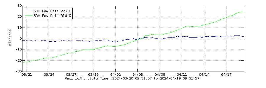
SDH, 1 month, live
IKI, 1 month, live
We interrupt advent for a new post! Iceland surprise – or not?
https://www.volcanocafe.org/the-ljosufjoll-earthquake-swarm/
I was once overtaken by a sheep going 80 miles per hour. On the road from Adelaide to Sydney. I was doing 70, which was allowed in those days. The sheep was being pursued by a Greyhound bus, so closely that I couldn’t see a gap between it and the bus’s front fender*.
As for The Devil’s Tower I liked it when Richard Dreyfuss built a large model of it in his bedroom. Always nice when a volcano becomes a movie.
(* Actual true story. Despite its amazing turn of speed the sheep wasn’t in good shape though, nor even alive.)
Sheep, Daleks, Sheepy Daleks and Sharknados.
Always a surprise. Never change, VC.
A new window has opened in this post!