
A freezer provides storage. And a deep freezer gives deep storage. You can’t go deeper than an original ice-age glacier. In Greenland, those glaciers are still there, being so tall that the top has remained in deep freeze even though the ice age is a distant memory. In this cryogenic environment, that frozen memory is still there. Even the heat of volcanoes was no match against the cold of the ice. The volcanic gas and dust that came down here was captured in snow, frozen in ice, and stored far below the surface. But no one documented the falls. Now we have a record of the past, but without a rosetta stone. We can see the story of the fire in the ice, but reading it requires more information. This post is about that attempt.
In the previous post we looked at how many eruptions we can see in the ice of Greenland and Antarctica, focusing on the centuries between 900 and 1500. The ice shows when something erupted somewhere and can separate the tropical eruptions from the southern and northern ones. Finding out any more, that was hard. It would be nice to know whether eruptions were brief or long lasting. It would be even nicer to know where the volcano was. And the ultimate price is finding out which particular volcano it was. That really does need a rosetta stone.

I will for now focus on the northern hemisphere. This is out of a slight obsession with the Viking world (did you notice?), but also because it should be easier to identify specific volcanoes. At the time, the southern hemisphere was still largely an unknown world, a volcana incognita. In the north, the world was beginning to be documented.
Let’s start reading. One warning: do get some coffee first as this post is quite long. The northern hemisphere turned out to be a big place. (As a test: there will be three millennium eruptions coming up. Can you find them?)
The freezers next door
 As helpfully pointed out in the comments on the previous post, a single ice core can miss eruptions, for lots of different reasons. The wind may have blown the wrong way and deposited the ejecta next door. A hit summer may have melted the annual snow and poured the dust off the glacier. It would be better to use more than ice core. The previous post used only the NEEM core, from the northwest of Greenland. But Greenland has been drilled in many places and there are other cores available. Several of these ice cores have been analyzed for volcanic signals and may have seen things that NEEM did not.
Sigl et al published data for three different Greenland ice cores: NEEM, NGRIP and TUNU. The NEEM ice core is from the northwest of Greenland. NGRIP (northern GRIP) is near the centre of Greenland, and a bit closer to Iceland. TUNU is from the northeast of the Greenland icecap, in a location which has airflow from northern Europe.
The sulphur records of the NEEM, NGRIP and TUNU cores are compared below. The two panels show the periods 900-1200 and 1200-1500 . There is clearly much more detail visible in NGRIP. Some peaks are much stronger in NGRIP than in NEEM, and may be absent in the latter. NGRIP shows over 50 separate peaks, or roughly one per decade. Many of these may be from Icelandic eruptions as it erupts at roughly that frequency. The NGRIP core is a bit closer to Iceland and NEEM can be in a rain shadow behind Greenland’s glacier, for winds from the direction of Iceland. For more distant eruptions, the frequency of once per decade suggests that NGRIP will typically VEI 5 eruptions. TUNU shows fewer volcanic peaks and does not appear to add much to NEEM and NGRIP. I will not use TUNU for this post.

EGRIP
A new ice core from east central Greenland has recently been made available by Seyedhamidreza Mojtabavi et al. 2020 https://cp.copernicus.org/articles/16/2359/2020/. The location is a little closer to Iceland so this ice core seemed worth looking at. The available data includes an age-depth profile and electric conductivity measurements done throughout the ice core. The conductivity is due to sulphates, but also to ammonia and salt from the ocean. However, the ice cap is very high and the ocean is far away. I will assume that the conductivity is dominated by volcanic emission.
The data does not give an age for every depth at which conductivity was measured. To calculate the ages, I interpolated the age-depth profile of EGRIP. In the original data tables (accessible from https://www.iceandclimate.nbi.ku.dk/data/), the age-depth profile is given in the so-called GICC05 (Greenland Ice Core Chronology 2005) calibration. GICC05 differs slightly from the modern tree ring record. I have applied the correction from Sigl et al for this. The main effect of this correction is that dates before about 1250 become a bit younger. The difference reaches 5 years for dates before 1000. This correction moves Eldgja from the original date of 934 to 939. The correction is less certain between 1000 and 1250 where I fitted a curve, and here the ages I find may be slightly off.

The EGRIP profile shows over 20 eruptions. This is far fewer than NGRIP: the conductivity measurement is perhaps not as sensitive as the sulphate measurement. If a peak is seen in EGRIP or NEEM, it is also visible in NGRIP. There are some differences in shape. The peak around 1110 is seen in all three ice cores but looks narrower in EGRIP (discussed further below), and this is also seen in the peaks around 1390 and 1460.
Time resolution
Time resolution is also important. For NEEM, we looked at annual data, i.e. the total sulphate over a full layer. But if an eruption is brief, it may only show up during a small part of the year. In that case, the event may stand out much better in higher resolution data, e.g. monthly measurements. In fact such a data set is also available for NEEM. In this post, I will mainly use the monthly NEEM data, rather than the annual data used in the previous post.
Eruptions on ice
So we have melted the ice cores (a little bit of it) and have retrieved the frozen smoke from the ancient volcanic fires. But where was the fire? Can we identify individual eruptions? We have one advantage. The chosen era of 900 to 1500 is when the Vikings had settled Iceland and had begun to live in the most volcanically active region in the world. They left us historical reports for Icelandic eruptions. The accuracy of those records should not be overstated. There are no written documents from early in the settlement: the oral history was written down only centuries later. Eldgja, the worst eruption of the entire post-settlement era, has left us no historical record at all. The first historically documented eruption is from Hekla just after 1100, but in spite of being reported with a precise year, this date appears to be wrong. The historical record becomes more reliable after the late 1100’s, but seems to disappear again after 1400 when the black death reached Iceland.
A brilliant list of reported eruptions (much copied on the interweb) was compiled by Jon Frímann Jónsson and kept at https://icelandgeology.net/?page_id=8046. When reading this list (it is highly recommended), do be aware that the sources on which this is based are themselves not always 100% reliable. Historical descriptions of events also do not directly indicate the size of an eruption.
Iceland is our best case. There are places with better records, but these have few or no volcanoes, whilst other places with troublesome volcanoes lack proper documents. There are no reliable historical records for any tropical or southern eruptions for this period. Nor do we have written records for northern Pacific volcanoes, with one exception: Japan. This makes it very difficult to assign particular ice peaks to specific volcanoes. There is an escape route: if tephra (volcanic dust particles) is found in the ice, it can pinpoint the volcano that is responsible, as the composition of the ejecta is different for each volcano. This has been done for a few eruptions within our time period: tephra has been found for one tropical eruption, one in Korea, one in the US, and two in Iceland. This already gives us an indication where the volcanic culprits will be found.

In the first post, I listed eruptions that occurred in the southern hemisphere, in the tropics, and in the northern hemisphere. The southern ones are absent in the Greenland cores. In many cases it will be almost impossible to pinpoint the southern and tropical volcanoes. As an example, Chile has 90 active volcanoes, has a significant eruption every few decades but has little or information on explosive eruptions during this era. How do you identify which Chilean volcano caused which Antarctic ice core spike? And that is just one country. (Admittedly Chile is not your average volcanic country but a stand-out performer.) Indonesia has 121 active volcanoes – it presents the same problem for tropical eruptions. Eruptions from the northern hemisphere may (perhaps) be easier to identify. Here I will mainly (but not exclusively) look at Iceland: can we relate the smoke in the ice to the fire in the documents?

If you are not fully familiar with Iceland’s magmatic scenery, I am happy to recommend the woolly mammoth guide to Iceland’s volcanoes. Read it, enjoy, but do come back to finish this.
Iceland
On our journey through Iceland, the first stop should be at the fissure region between Katla and Vatnajokull. It is colloquially known (but only in VC) as the ‘dead zone’ because of the lack of earthquakes. This region seems a funny choice to begin our search: it lacks volcanoes. But the lack of earthquakes tells us there is something going on. Regular magma injections from the volcanoes on either side have kept the upper crust here hot enough to avoid brittle earthquakes. In spite of the absence of deep magma chambers, this is a highly active zone. In fact, the largest eruptions of Iceland have happened here. This is the domain of Eldgja and Laki. And our exploration begins with Iceland’s biggest eruption of modern times: secret Eldgja, unheralded and unrecorded, but 30% larger than Laki.
Eldgja
 We have written extensively about this eruption. It opened a 70-km fissure, in the same region as Laki but with magma obtained from the other end of the region. The magma was sourced from Katla. There is some suspicion that Eldgja is the reason for the lack of any historical record of the settlement era (870-930) of Iceland. The eruption coincided with the end of this era (not accidentally, I expect), destroyed a coveted area of Iceland which was wooded and fertile at the time, and cut the travel links between east and west. If Laki reduced the population of Iceland by a quarter (through both death and migration), what did Eldgja do? We do not know. The settlers left us no diaries or stories, apart from suggestions that the imagery of Ragnarok was borrowed from Eldgja. Did everyone able to document the events die from it? That is entirely possible. Travel was agonizingly slow, and a sedentary population could easily have been overtaken by events. Farmers like to live near (but not too near) rivers. Lava would have come down from the highlands following those same rivers. Without communications, there would have been no warning of the streaming lava arriving in the dead of night.
Eldgja gives an obvious signature in many Greenland ice cores, in fact it is the largest ice core signal in the entire post-settlement sequence. Small tephra fragments were found in the ice core, and the composition matched those found on the ground around the Eldgja fissure. This proved the association of the sulphate spike with Eldgja. The ice now allowed us to precisely date the eruption.

Click on image for full resolution
All three Greenland ice cores show the extreme spike. It is even (very faintly) seen in Antarctica. That goes against expectation. Eldgja was effusive, with limited explosions. At 20km3 of lava, it put a massive amount of sulphate in the lower and middle atmosphere but little or none in the stratosphere. The wind spread the sulphate across the north and to the tropics. Here, being in the troposphere it passed below the barrier of the stratosphere to make the forbidden crossing into the southern hemisphere. This Icelandic fissure eruption could be smelled over the entire globe. No other eruption could have done this: it took a massive amount of tropospheric sulphate to travel that far. This is perhaps a warning how bad a proper flood basalt would be: such an event could poison the air everywhere in the world.
The high resolution (monthly) NEEM core puts the onset of Eldgja as very sudden in the late spring of 939. The emission peaked within months, declined, showed a second peak towards the end of the year, a phase of constant, slower emission in the first half of the following year, and a slow ending during the remainder of that year. It lasted for 18 months in total, but most of the emission was in the first few months. That is very similar to Laki, which also lasted a year and a half, but spend most of that time petering out. The summer eruption of Eldgja must have devastated Iceland’s farms.
The NGRIP and EGRIP cores show the same pattern as NEEM but with less detail. There is however one clear difference: they have the peak one year earlier. The eruption was in 939 according to NEEM but in 938 in the other two cores. This is not the vagaries of the wind, but a difference in layer counting and age calibration; it is within the uncertainties. (Do note that these dates are in the tree-ring calibration; in the original GICC05 calibration the eruption was in 934. Also note that I adjusted the EGRIP core to the Sigl et al calibration.)
Can we tell which core is right? Here the lack of historical records from Iceland becomes problematic. There are however a few records from Ireland and from Italy which mention a red and faint sun in 939. Tropospheric sulphate, as in a fissure eruption, is different from stratospheric sulphate, as after a large explosive eruption. Tropospheric sulphate moves with the wind and changes from day to day. It doesn’t give months of faint sun like Tambora did. The records talk about days when this happened, not weeks or months. Tree rings show that 939 was a poor year for tree growth, but this lasted only one year. The winter of 939/40 was rather cold in western Europe, with frozen rivers even in Ireland. It was followed by famine which became worse later, especially in France in 942. The details are insufficient to call this a volcanic winter. The cause of the famine is not clear, since the weather was not that poor – drought may have played a role, but it is also very much possible that the clouds of sulphuric acid damaged crops across Europe. The Nile had low water levels in 939. The Nile flood is June – September, and is fed by summer rains in the mountains of Ethiopia. A similar low Nile flood was seen after Laki, and it suggests that sulphate somehow limits the monsoon rains, perhaps by suppressing convection in the atmosphere. It appears that the main influence on the weather was in the summer of 939. The data fits best with Eldgja happening in 939, as in the NEEM core. The case is summarized by Oppenheimer in 2018, https://link.springer.com/content/pdf/10.1007%2Fs10584-018-2171-9.pdf
There is a bonus eruption in the ice. Did you notice the small peak at 946? Tephra in the ice core has identified this as the Paektu eruption, also known (not entirely accurate) as the millennium eruption. It is clearly seen in the NGRIP core (note that this should be shifted up by one year). Not all Greenland volcanics are from Iceland! But the Paektu signal, in all its high-VEI-6 strength, is dwarfed by Eldgja.
Veidivotn
There is another dead-zone rift eruption hidden in the ice. This rift eruption is Veidovotn, much less well known than Laki or Eldgja. It took place in the same general area of as Eldgja, a bit to the northwest along a 40-km rift between Bardarbunga and Torfajokull. While Eldgja was fed from Katla, Veidivotn counts as a Bardarbunga eruption.

This was an unusual eruption: even though it was a fissure, it erupted mainly explosively, with 3.5 km3 of tephra but less than 0.5 km3 of lava, all basaltic. The lava has been dated to 1480+-11 years. And just as for Eldgja, there is not a single written record of the eruption. It is as if Iceland lives in denial of its rifts. I blame the Vikings.
The eruption is very obvious in the ice signal. It is strong in NGRIP but weaker in NEEM. Unlike Eldgja, it is not present in the Antarctica (blue) core. The signal begins in the autumn of 1476, peaks early 1477, perhaps February, and ends in spring, perhaps April. The eruption was during the winter, and peaked at the coldest time of the year. This may explain the lack of a written record. It was not the season to be outside in the harsh landscape of the dead zone, the lava did not get far, and the eruption had limited impact on farming.

click on image for full resolution
Does the time of the year explain the explosive nature? This is an area currently known for its lakes. In winter, the lakes would have been frozen and the eruption needing to break through the ice.
Let’s move on from the dead zone to the massive glacier of Vatnajokull, source of the majority of Iceland’s eruptions. We can be rather quick, since eruptions here are generally not documented. It is too far from any settlement, and eruptions here were largely ignored. Often only the jokulhaups were mentioned, the floods coming down the rivers which often -but not always- have a volcanic origin. There are likely to have been a large number of eruptions at Grimsvotn during this time. some of which may have reached VEI 4 or 5, but we know nothing about these. There is however one exceptional Vatnajokull eruption.
Oraefajokull
In June 1362, a large explosive eruption of Oraefajokull turned the remaining farmable region on the south coast into a wasteland. The output is estimated at 2.3 km3 tephra and 0.1 km3 pyroclastics, and the eruption column may have reached 30 km. This was the largest rhyolitic explosion in Iceland after the settlement era. A stratospheric VEI-5 just 130 km from the ice should give a nice, strong signal.

click on image for full resolution
It didn’t give any signal. This large, nearby, perfect eruption is invisible in all three ice cores. We know that the ash reached Greenland, because tephra has been found there. But sulphates show nothing. It is a mystery.
There are several possible reasons for the missing signal. Wind direction may also play a role. Ash is distributed lower in the troposphere and sulphate higher: if the wind direction was different at different altitudes, ash and sulphates may have taken different paths. The answer may be in the rocks. Rhyolitic explosions blow out lava which has been in the crust for some time, perhaps centuries. Over time, the sulphur escapes from the lava, especially it it is within a few kilometers from the surface. This affects fissure eruptions much less because those erupt fresh magma. Rhyolitic eruptions get much of their sulphur not from the magma (which is degassed) but from the rock which they pulverize. The sulphur budget of such as eruption depends on the composition of the mountain. In the case of Oraefajokull, the rocks perhaps contained rather little sulphur.
There is no indication of any effect on the weather in Europe from Oraefajokull but that is not unexpected as the eruption was a bit too small for that. In 1362, the storm of the century devastated Ireland, England and Western Europe, with reports that trees were sucked out of the ground complete with their roots, but this happened in January, 5 months before the eruption, and can’t be blamed on it. (As discussed earlier in this blog, in Germany a flood disaster has been named after this storm, the Marcellus flood. That flood, however, did not happen. There were major floods at other times in the 14th century but not in 1362.)
In our Icelandic journey, we turn to the southern volcanic area. Here, the usual suspects are Katla and Hekla, two very different volcanoes.
Katla
Katla is a fairly regular eruptor. Since 1918 she has taken a break, and is doing a Sleeping Beauty impression while waiting for the kiss of a passing volcanologist, but don’t let this fool you. Before falling asleep she had an explosive temper, and you would be well-advised to check compatibility before marrying the beauty even to a volcanologist. Katla has produced 20 known eruptions since the settlement, not including Eldgja. 11 of those occurred in the period 900-1500: 6 small, 2 moderate and 2 large. The ‘official’ list is tabulated below.

From T. Thordarson, G. Larsen, Journal of Geodynamics 43 (2007) 118–152
For the 920 eruption, there is a peak in the ice core in 919 but it is also seen in Antarctica and so was not Icelandic. The date of this Katla eruption is rather uncertain. The same is true for its 1179, 1357 and 1440 eruptions, where the dates are too uncertain to allow for a search of the ice record.

The 1245 eruption coincides with a feature in NEEM. The 1262 eruption may also be detected: the NGRIP core shows a clear peak in this year. (There is a larger one in 1261 and the eruption of the millennium -which is not the millennium eruption – was around 1259: this is not an easy time to identify eruptions!) There is a weak spike in 1415 in NGRIP which may or may not be the 1416 eruption. That leaves us with three possible detections for Katla of which 1245 and 1261 seem likely identifications; the second one coincides with a large Katla eruption which is encouraging. Katla does not often leave its sign in the Greenland ice, probably because its eruptions are not energetic enough. Perhaps we should let it sleep and convince prince (m/f) volcanologist to move any romantic attentions elsewhere.
Hekla
 This is Iceland’s dark horse. For such a small mountain it is surprisingly active, but it is also utterly unpredictable. Its magma differs from the usual Icelandic compositions. Hekla does both explosive and effusive eruptions, and sometimes both together. It gives no warning and is happy to either sleep for centuries or erupt twice within a few years. Even in the Middle Ages, Hekla was the one that terrified the hell out of people, to the degree that Hekla became synonymous with hell.
Hekla started out as its own sleeping beauty. For the first 200 years of the Viking presence, it slept. It was woken early in the 12th century. This was unwise, in hindsight. This beauty turned out not so much a dreamy princess as an evil queen. Sometimes it really is best to let sleeping beauties be. Ever since, Hekla has left its marks both on Iceland and on Greenland.
Hekla had a major eruption during its rude awakening in 1104 (or thereabouts) when it explosively erupted 2.5 km3. Strangely, the 1104 eruption is not apparent in the ice cores, neither sulphates nor tephra. The Hekla tephra was deposited mainly to the north and east, and so the wind direction may have kept it away from Greenland. However, the date is not fully certain. The eruption must have happened before 1118 but the dating to 1104 comes from one document, written later. There is an ice core peak eruption around 1110 and it makes sense to consider this as a candidate for the Hekla eruption. This peak is most obvious in the NEEM core. This ice core feature is a complex one which we’ll come back to in a minute. There is a second candidate peak in 1115.
After this explosive awakening, Hekla had eruptions in 1158, 1206, 1222, 1300 (0.5 km3), 1341, and 1389. The first three were small, the 1300 event was large and explosive, that of 1341 long lasting and locally destructive, and 1389 was both explosive and effusive where the lava flow produced the 0.25 km3 Norduhraun.

The 1158 and 1206 eruptions are not visible in the ice cores. The 1222 and 1300 events are seen only in NGRIP. The other two eruptions have produced clear signals. 1341 produced a strong peak in NEEM and NGRIP, and 1389 is very clear in all three cores. The pattern from this is that small Hekla eruptions (1158, 1206) do not reach the ice of Greenland. 1158 does not even show tephra in Iceland itself, and 1206 was also small but did produce some local tephra.
1222 was very similar to 1206 but it is very clear in the ice. This eruption is described as causing a ‘red sun’. The eruption of July 1300 was large but is weak in the ice. 1341 and 1389 left strong signals. May 1341 was a major eruption leaving ankle-deep ash and turning day to night. 1389 started with a large explosion which was heard across Iceland, but evolved into a fissure eruption which produced an 8-km long lava flow and lasted into 1390. The ice cores indeed show that the sulphate peak lasted a year.
Short eruptions may be quite dependent on wind direction. The 1222 eruption was smaller than that of 1300 but left a bigger impression in the ice. The wind may have been more favourable. however, the tephra of 1300 was carried northward and that of 1222 eastward, so that doesn’t fit. Perhaps the 1222 eruption reached higher in the atmosphere, as suggested by the ‘red sun’, allowing sulphate to spread further.
That leaves the 1104 eruption. There is nothing visible at that year. However, knowing that it could have been any time before 1118 gives us two strong candidates, one at 1115 and the other around 1110. The 1110 event lasted from 1109 to 1112. It consists of two patterns. One starts suddenly in 1109 and slowly tapers off towards the end. This pattern is strong in Greenland but is in part also visible in Antarctica. That points at an eruption at lower latitudes. The sudden start and slow decline is typical for an effusive or rift eruption. Superposed on this is a strong sharp peak in 1110, seen mainly in NEEM. It needs high time resolution to separate it from the long-lasting eruption. There may be a counterpart in Antarctica but that is not clear. Confusingly EGRIP agrees with the long-lasting eruption but shows the sharp peak earlier. That leaves us with two potential identifications for the first Hekla eruption: late 1110, or late 1114. We don’t have enough data to decide between these.
Volcanic winter?

Asama

Click on image for full resolution
Let’s look at this in more detail. Asama may indeed have contributed to the sulphate peak. The plot shows that the onset of the sulphate was at the precise time of this eruption, in October 1108. (Japanese records can be impressively detailed compared to the Icelandic ones of this era!) It is only seen in Greenland. The second peak is around October of 1109, and is seen in EGRIP and NEEM, shortly afterwards followed by a peak Antarctica. This would seem closer to being a tropical eruption, but still with the sulphate reaching Greenland first. The cold summer of 1109, as indicated by the tree rings, cannot be due to this eruption, nor can it come from Asama unless that was very much larger than appears from the reports. English reports mention quite a poor summer in 1109, but there was worse weather in 1110 with frost damage in May and too much rain which might be related to the October 1109 eruption.
A third eruption occurred late in 1110. This is seen mainly in NEEM – there may be a small counterpart in Antarctica at the same time but this could be noise in the data. The fact that the 1109 and 1110 peaks are not seen in all three Greenland cores suggests that these were fast and local events, something you may expect from a VEI-5 eruption. The winter of 1110/11 was severe but the summer of 1111 (how is that for a year number!) was rather dry with good crops. Overall, the weather was not that unusual and there is not enough here to call it a volcanic winter. Neither was there a record that the sun appeared faint. (A comet was seen above the northern horizon between 9 and 30 June 1110, and so at that time the sky must have been reasonably clear.) The case that Guillet et al make for a major volcanic weather event is not fully convincing. The data does suggest three VEI-5 eruptions but that is insufficient to impact the weather.
The one open question is the long tail towards 1113. That looks like a fissure-type eruption and Iceland is the most likely culprit, but no such eruption is reported. There is a possible candidate in Iceland: the 35 km long Frambruni lava flow due west of Askja, part of the Bardarbunga fissure system. The field contains around 4 km3 of lava, several times larger than Holuhraun. It formed before 1362 but the date remains uncertain.
This leaves the identification of the Hekla eruption open. It could be late 1110 or late 1114.
Other Icelandic eruptions
Hallmundarhraun ~950
 This is a 8 km3 lava field northwest of Langjokull. It is thought to have formed in the 10th century but a precise date is not available. The lava flow extends over 50 km in length, is riddled with lava tubes and seems to result from a good attempt at building a shield. Such a large eruption should have left an ice record, and as it was effusive a significant sulphur output is likely. The lava tubes became caves, which were occupied by the early Vikings and later by a variety of outlaws including a group of priests(!?). Carbon dating of animal remains has indicated that the caves were occupied by 930. The eruption must have occurred earlier than this. The ice core has a peak around 908 and this is a potential, but far from certain, candidate. For more information, see Samir Patel, The blackeners cave, https://www.archaeology.org/issues/255-1705/features/5468-iceland-surtshellir-viking-cave.
Reykjanes
The series of eruptions at Reykjanes (see Hector’s post) from the 10th to the 13th century has left little record in the ice core. That is understandable, seeing that the current Fagradalsfjall eruption is minor, is only affecting a small area and is also somewhat sulphur-poor. There are exceptions though. The ice core show a large number of small peaks in the period 1200-1250, especially around 1210, 1226 and 1240. These roughly coincide with a phase of eruptions off the coast which formed several islands. Subsea explosions can be very ashy and indeed these eruptions are recorded as having caused darkness and sand winters. The sulphates of these eruptions may have reached Greenland. However, no Reykjanes eruption is detected with certainty in the Greenland ice cores.
An eruption happened off the coast around Reykjanes in the Eldey volcanic system in 1422, which over a few years created a short-lived island. There is also no obvious peak in the ice core signal from this eruption.
The case against Iceland
At the moment, with the on-going and well-documented Fagradalsfjall eruption which seems to last forever while always doing something new, it becomes easy to forget that there are other volcanic areas in the world! The Greenland icecap contains more than just Iceland. However, although it is sometimes possible to associate the Icelandic records with the ice, to do the same with other volcanoes is much harder, for lack of accurately recorded eruptions. Who knows what Alaska did in the 12th century? How about the Azores which erupted perhaps 4 times per century, but lacked a trained observer with pen and paper?
Vesuvius
There are European volcanoes with historical record. We have some reports of eruptions from Vesuvius, at 991, 999, 1006, 1037 and 1139. Of these, only 999 coincides with a peak in the NEEM ice core, and 1139 coincides with a peak in both NGRIP and NEEM. The 1139 peak is worth investigating, but it is not possible to confirm an association because the sulphate peak was 6 months before the eruption. Vesuvius is more distant from Greenland, and its eruptions may not have been large enough to spread sulphates that far.
Etna
This volcano is surprisingly poorly documented in this period. There was a damaging flank eruption around 1130. The ice record shows an extended but weak peak in 1129, and this is a potential candidate. But to confirm this would require more accurate history.

Paektu
This volcano has been mentioned already. The 946 caldera-forming eruption is seen in the ice, although unexpectedly weak for such a large (high VEI 6) event. Tephra has been found: it is perhaps surprising that tephra traveled such a distance but sulphate was limited. The eruption may have been quite sulphur-poor. There are no European reports of poor weather around this time.
We do have historical records from Japan, and two eruptions are of interest.
Asama
This 1108 eruption is already mentioned above.There is very good agreement between the historical date and the ice core record.
Towada
 This volcano had a large eruption (2 km3 DRE with extensive ignimbrite) carbon-dated to 1250 BP. It has been identified with an eruption dated to 915, Aug 17. It is large enough (high VEI 5) to potentially be visible in the ice but none of the ice cores have a peak in 915. The date comes from a single old document. The lack of an ice core signal may not be a problem (other VEI 5’s have been missed) but it suggests that the date may need to be reconsidered.
Ceboruco (tropical)
This is a case where the carbon dating is unusually precise. The large (plinian) eruption (VEI 5-6) of this Mexican volcano is dated to 1005+-15. It is called the Jala eruption. The date is based on multiple carbon fragments. The best one by itself gives a date (calibrated calendar) of 945-1022. The volcano is at 21 degrees north and is therefore tropical. The peak is indeed seen in both Greenland and Antarctica. However, in this time period, the relative calibration of the ice core dates is not as precise. As can be seen, none of the ice cores line up perfectly. This caused the algorithm used in the previous post to miss the association, and wrongly classify this eruption as ‘north’.

Within the time range, the most likely peak is in late 1001. This one is in fact the true millennium eruption! However, as it is tropical it does not belong in the list here, and is mentioned only because of the misidentification as ‘northern’ in the previous post.
And finally, one further eruption has been identified through ice core tephra. It is American.
Mount St Helens
 St Helens is a frequent exploder (and rebuilder), so it may not be a surprise to find it in the ice core record. Its eruption of 1479 caused widespread tephra in the region and was powerful enough to deposit glass in Greenland – although to be fair, only a single micro-shard has been found so you should not envisage a hail storm of volcanic glass. I can’t say any more about this detection because it was published in a journal that no university I am aware of subscribes too. It is behind the most insurmountable paywall I have ever seen. (One does wonder what is the point of publishing important work where it can’t be read. But I’ll follow the preference of the authors and won’t cite the work.) The eruption has been accurately dated though the local tree ring record; it is classified as a VEI 5. There was a second eruption 2 years later, in 1482, also classified as VEI 5 but it was smaller. Two ice cores indeed show a very clear peak at the end of 1479 or early 1480 – it is missing only from the less sensitive EGRIP data. It looks small compared to the Veidivotn peak two years earlier, but is clearly detected. The second eruption may be seen in the NGRIP core, in the summer of 1481, but the other two ice cores do not show it. Note that there is also a bit of a feature in Antarctica, but this is not strong enough to be a certain detection. A counterpart in Antarctica would be unexpected.

That brings our list of possible identifications for northern-hemisphere eruptions to a close. The remaining parts of the north lack sufficiently accurately dated eruptions to allow a detailed comparison with the ice. For instance, Augustine has two reported eruptions within our time window but they are rather small and have dates accurate to +-50 years. That is too much uncertainty for a small eruption to be identifiable. But if you know of any more identifiable eruptions, please let us know!
Here is the plot with the identifications that we have been able to make. This shows the NGRIP core with the tropical and southern eruptions removed: it only shows eruptions from the northern hemisphere. The labels indicate the eruptions. Oreafajokull is in because of its tephra in the ice.

Northern hemisphere eruptions in the NGRIP ice core. Tropical and southern eruptions were removed. Identifications are listed. H is Hekla, K Katla, O is Oraefajokull (detected only in tephra)
Clearly, we have had some success. But many eruptions remain unclaimed, including some large events: VEI 5, perhaps an occasional VEI 6. Iceland will be responsible for some; it may even include some fissure eruptions we had not recognized or dated correctly. The Azores may be there as well. The northern powerhouse from the Kurils to Alaska will be responsible for some, not just St Helens, and this region can do large and undocumented eruptions. There is a lot of research to be done.
And we still need to look at the tropical and southern volcanoes.
Albert, August 2021


Fire and Ice – I like it.
“I hold with those who favour fire”
Fagradalsfjall is still bubbling and flowing nicely. I had the impression that earlier today a trickle reached Natthagi – at least it smoked at the entry point. But all the flows are again into Meradalir.
Kilauea is lighting up like a christmas tree
I see that…there’s not been an eruption in the Near-Caldera East Rift Zone (NCERZ?) in a long time, the furthest up has been Hiiaka in 1968 and that was one of those eruptions where 99.5 of the intrusion stays in the dyke.
I think this seismic event makes the turn and heads to at least Mauna Ulu and perhaps Napau. That’s my $.02…
That part might be physically prevented from erupting by the way the conduit goes against spreading. The eruptions near Keanakako’i and Lua Manu are inside the caldera fault, Puhimau is right outside that fault and probably formed along it, along with the thermal area being some magma leaking up it. But Puhimau to Hi’iaka the last eruption in that area I think predates the formation if the caldera, it at least certainly predates the 1790 collapse that created a deep caldera, the stress field is not right to allow eruptions there today unless it was a rogue deep conduit – basically the same as we see in Iceland – which surfaced there and avoided everything else. I dont think that can ever happen at Kilauea though because the deep rift is still there, the koae faults being the southernmost boundary of such and the modern conduits being just a well worn path along the surface if that.
This spreading is also why I think quakes show so much at the UERZ, the rift that can actually erupt spreads parallel to the magma, but this part has to go at an angle, it will never close as the magma is much hotter than the melting point (Halemaumau and Hi’iaka both have temperature records over 1200 C) but it is stuck as a tube while the rest can fill more silently and only quakes u der pressure. There is probably active magma as far as highway 130 based on the south flank movement.
I would also guess the active part of the rift, just like the summit, has a direct contact with the crystal mush of the deep rift. The connector though could actually be entirely in solid rock. There is some deeper rift transport though most is through the conduit as actual liquid.
I do hope this made sense… 🙂
Sometimes I wish there were less words in the english language..
“Big volcano, it go bang. Not yet.”
I wouldn’t write off the possibility of a substantial volcanic winter from a VEI 5, some explosive eruptions had 1-3% of their erupted mass consisting of SO2 and for a VEI 5 especially one taking place firmly in NH could cause a decent volcanic winter
On a lighter note: It seems our doomsday scenario with regard to the “little turbine that could” were overly pessimistic – it’s literally standing its ground 🙂
TUNU shows spikes a bit after 1300 and around 1355 and 1365 none of which show in NEEM, EGRIP, or NGRIP.
Wouldn’t want to see a repeat of that in modern times, especially if you have a lot of air miles saved up. A super-Eyjafjallajökull? No thanks.
Hi Albert,
Great article, as always.
On the off chance that my University may have access, in which journal was that article about Mt. St. Helens published? I’d be happy to give it a try…
It was published in the journal Quaternary Research. It is an older paper (1993) republished in 2017 on-line. Zielinski was one of the authors
Hi Alberta,
If this is the article you’re looking for:
Author: Joseph Fiacco
Title: Characteristics and Possible Source of a 1479 A.D. Volcanic Ash Layer in a Greenland Ice Core
Source: Quaternary Research [0033-5894] yr:1993 vol:39 iss:3 pg:267-273
I got the PDF for it, i.e. my University gave me access through the Canadian library network.
What’s the best way to send it to you? Should I e-mail to this address: volcanocafe.org@gmail.com?
yes please. and thanks!
PDF e-mailed.
Enjoy.
Great multiview right now
Kilauea is inflating rapidly on the tiltmeter now, which only happened immediately before the eruption in December. All the quakes too, it will erupt this week for sure if this keeps up possibly even today.
The thing is none of these quakes would not be noticeable to people who were not lying down. I do wonder seriously if the so called ‘earthquake sense’ every other animal except us apparently has is because we wear shoes, dogs dont wear shoes… anyway someone sitting at the caldera this week is going to get a real surprise 🙂
The outflow from the Fagradals vent appears to be encountering a block. The vertical splash is quite intense!

Clive, I have been watching this strange obstruction feature for several hours now, at least 5 or so. The hot lava doesn’t seem to have melted away the obstruction, it stubbornly stays in place. Right now at 4:55 am, you can see chunks of cooler lave carried by the fluid lava, slowly rise up to the top of this obstruction before whisking along again.
I have 2 thoughts, could this obstruction be a fluid velocity discontinuity, where the faster lava leaving the cone, suddenly slow down because the lava on down the stream further is moving more slowly? This is like trying to shove too much lava too fast and so it backs up?
Secondly, we know that the viscosity of the lava changes with temperature, could a sudden increase in viscosity cause this change? I don’t consider it likely, but we have seen how the lava slows down with cooling.
One thing I do know is that after watching this for several hours, it seems to stay in place at this point of the stream, perhaps the material behind the obstruction has a higher melting temperature than the lava hitting it? You would think that the mild abrasive effects of the lava would wear the obstruction away, but it has stubbornly remained.
I am quite curious about this obstruction and why it has persisted
– Randall
this clip might give You another view of Your persistant obstruction… (maybe) https://www.youtube.com/watch?v=exTwIb86nmU
The flow is dropping down onto this obstruction and being forced up over, and it’s splitting into 3 separate flows.
Is this the errant ‘tooth’ ?
https://www.youtube.com/watch?v=exTwIb86nmU actually shows what is really going on here. Sigh, I wish we had drone overflights of the cone every hour if possible. Now I see that the obstruction was MUCH bigger than it look sideways in the camera and that the flow was being diverted 3 ways. My question was almost instantly answered when I saw the drone video
The build up to the next episode has begun. Of course, last time this took several days. But you may get more views tomorrow if it continues
I think the lava goes undercover here. It is trying to squeeze into a short tube
Yes, looking carefully it could well be a sideways view of a tube entry. The foreground solid is some way away from the flow and the flow has to change direction from flowing away from the camera to drop down and towards the camera, causing the standing wave.
Pretty impressive and constant flow, looks like the giant had a nasty gob in his throat but no has blown his airways clear and is breathing well.
Ought to guess how long before he starts gurgling again, I give it 48 hours from the start.
Oh dear, that post stopped it dead ……
Yes it did. Th tremor graph showed a sudden drop, recovered for a bit but then gave up. On camera is stopped around 9:06. No obvious cause. It has been an impressive episode.
Excellent report !!
Given that Greenland is close to Iceland and might be disproportionately affected by Icelandic eruptions, compared to, for example, Kamchatka or Alaskan eruptions, might it be possible to look for ice cores in Siberia or Alaska?
Though, getting sampling equipment to an unmolested glacier on Denali might be difficult.
I worry about getting tunnel vision and assuming everything is Icelandic, just because you have written records and/or an interest in the area.
Very interestings points made though, especially about rhyolite being less sulfuric (VEI might not correlate with ice core sulfates in terms of size of eruption) and about poisoned air during a flood basalt.
There are quite a few ice cores from Alaska and I did look at them. They don’t go back far because the glaciers are not as thick, and so they are studied mainly for the past few hundred years. And mainly for global warming, a forbidden topic in the last four years. The best ice core I am aware of is this one: https://agu.confex.com/agu/fm20/webprogram/Paper681939.html I am waiting for analysis! The white river ash has been studied in Alaska ice cores but it falls outside my time frame. Lake sediment is another good source when looking for tephra. Harder to date though.
Sad it only goes to 800AD. If they were able to go 300 years further back in history, perhaps we would have a better clue of where to look for the 535 eruption.
That looks like it would be a very interesting talk or poster.
I found a PhD dissertation with a manuscript from one of the authors on that abstract.
Will send to the volcanocafe email above.
Mostly it is about C14 dating but has other isotopes too.
The thing is that icelandic weather systems are pretty well from the west, so I would not be at all surprised if signatures at greenland would be muted or absent unless large enough to circle the world. Albert needs to plug in an attenuation factor for predominant wind direction when assessing greenland ice cores.
These may be very large.
The weather systems are from the west but the wind is not. The dominant wind direction in Reykjavik is easterly. The low pressure systems often pass south of Iceland, giving southeasterly winds. It is different in the summer months when the polar front and low pressure systems are further north and the wind is more changeable. This also causes the fogs we have seen and cursed. Higher up in the atmosphere the winds are different
Nice article Albert, thanks.
About the dominant wind directions.
Isn’t (wasn’t?) there a winterly highpressure belt above Canada/Greenland dominating the weathersystems in wintertime?
There also can be a very persistent small scale highpressure dome over Greenland, just fitting on the countries contours.
Southern Greenland icecores (DYE) may be a better reference for volcanic deposits?
I did look at the dye-3 core. It is quite old and was studied in the 1990’s. The published data is not accurate enough and I could not find the original data on-line.
In addition to the points raised above, note that circling the world at high latitude is not as big a deal as doing so at the equator. If you math it out it turns out that the distance traveled varies as the cosine of the latitude, so at 60 degrees north (or south) it’s only half what it would be at the equator.
https://youtu.be/KHaM-mJEeVQ
Nice video starting with the backside view behind the crater; how small those little cones look beside the ‘monster’!
Nice camera work
Albert, I got to the end of your article. Many thanks for a very scholarly piece of detective work! Fascinating reading.
People out on the lava.

Things didn’t go as planned for Perseverance’s first sample collection attempt.
Forgot the link https://mars.nasa.gov/news/9007/nasas-perseverance-team-assessing-first-mars-sampling-attempt/
As they say, the risk of ‘breaking new ground’ (awful pun but they are NASA engineers, not linguists). It failed during the transfer of the rock bits from the drill to the container. Maybe the helicopter can help? They suggest (in between the lines) that perhaps the rock fell apart.
Well they could land the helicopter on top of the hole and then run the blades in reverse to suck the sample out 🙂
Being serious though it might mean Ingenuity’s next flight is brought forward depending on how long they take to troubleshoot.
A bit of background on what went missing.
https://www.nature.com/articles/d41586-021-02166-6
Note that smoke (aloft) from all the western N.A. wildfires has now reached southern Greenland, with Iceland next?
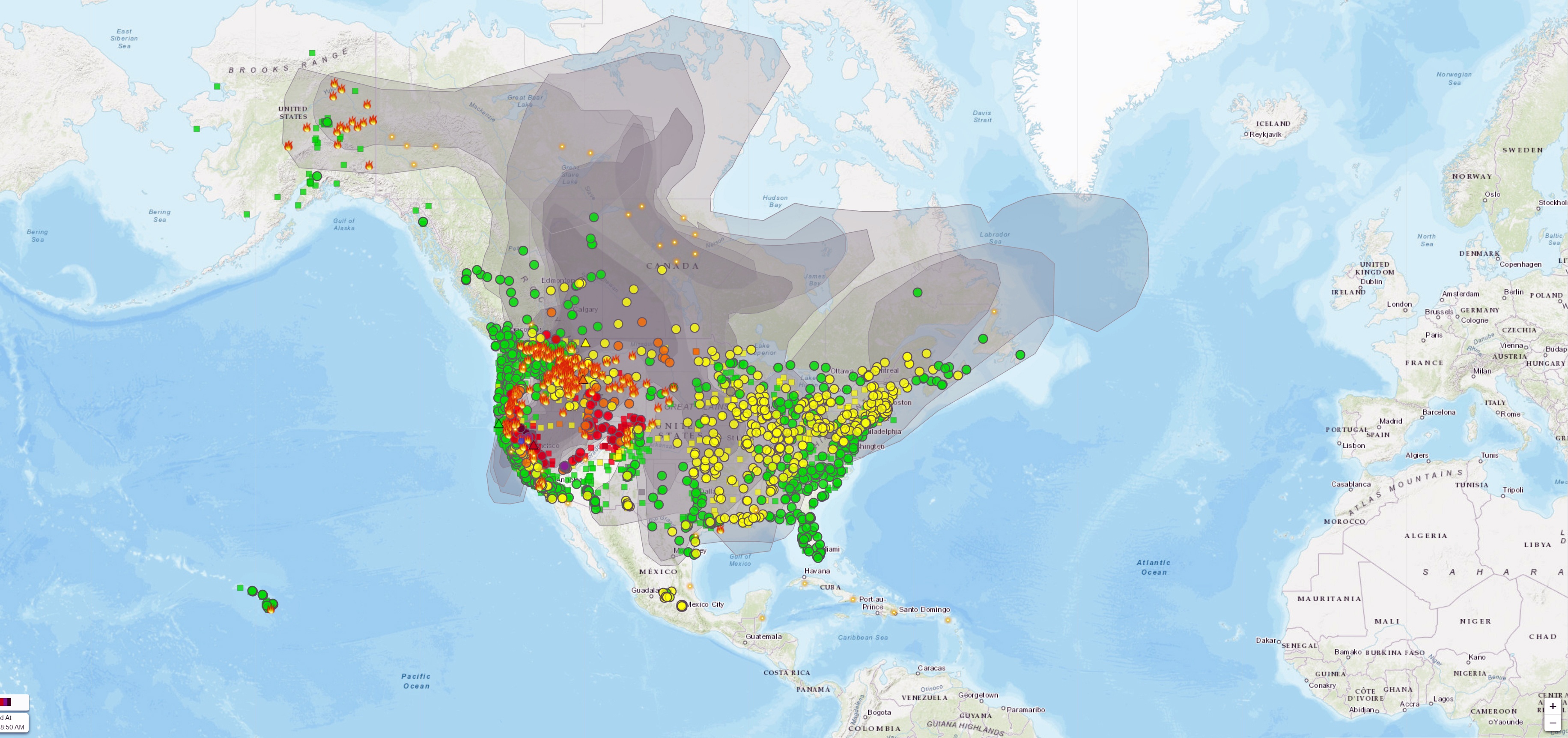
ATTM, it appears that virtually all of north America is experiencing smoke issues to one extent or another.
Here in Northern California, and many states west of the Great Lakes, air quality is off-the-charts bad in places with AQI exceeding 600.
Given the mega/giga-fires that the planet has seen the last 3-4 years, I wonder if future climatologists analyzing ice cores (assuming some survive) will be able to figure what exactly happened when the earth shook and the sky burned.
Hi Craig, may I ask where you found that map, please? Ireland looks as much to be in the line of fire (poor pun) as Iceland. I tried reverse image search but can’t locate it.
Here it is.
https://fire.airnow.gov/
17.24 local time approx. major collapse of inner cone on southern side. Lots of brown dust
Nice catch
21.41.45 pm, pink glow and lava splash showing; a very quick bounce-back considering a fair chunk of wall must have fallen into the vent.
I just saw this. Don’t know if it’s real or some other explanation.
https://www.visir.is/g/20212140808d/kanna-hvort-eldgos-se-hafid-nedansjavar
Giggle translate suggests an entirely new type of eruption
‘an announcement was received that upholstery could be seen rising from the sea west of Krísuvíkurberg’
But as no other indication exists for an eruption, I have my doubts. Let’s see.
That made me giggle.
Apparently the Coast Guard is sending the Patrol Ship, Þór to investigate.
Using their suite of instruments, I’m sure they’ll be able to furnish us with the facts before long. They may have to cushion the blow if it is bad news, but let’s hope they do not spring any surprises upon us.
This is all we know sofa.
I’m on tenterhooks… hoping they don’t embroider the tale, and have us all unpicking our carefully crafted theories.
All part of life’s rich tapestry.
You couched that perfectly.
Tailor made for the armchair experts. Should have it well covered.
RE:”‘an announcement was received that upholstery could be seen rising from the sea west of Krísuvíkurberg’..
That would almost guarantee a front row seat for the show!!
Icelandic Coast Guard dispatches vessel to investigate possible underwater eruption near Krýsuvík:
https://www.ruv.is/frett/2021/08/07/kanna-hvort-gos-se-hafid-nedansjavar
Giggle translate
“The Coast Guard has sent the patrol ship Þór to investigate whether an eruption has started underwater, west of Krísuvíkurberg. The Coast Guard received a report just after eight o’clock tonight from a passer-by at Selvogsvita who had seen dark gray plumes of smoke out at sea. This is confirmed by Ásgeir Erlendsson, the Coast Guard’s information officer, to the news agency.
The patrol ship Þór is now on its way to the scene, but it was at Þorlákshöfn. Ásgeir says that it is still just over an hour before Þór arrives on the scene. Until then, no further information will be available. The Meteorological Office also monitors earthquakes in the area, but nothing has yet been seen on the Meteorological Office’s measurements.”
So far, the Coast Guard reports nothing unusual in the area:
https://www.mbl.is/frettir/innlent/2021/08/08/ahofnin_vard_einskis_vor/
Is the rising upholstery in any way related to underwater pillow lava?
Just another reminder that Google Translate is your friend …
… specifically, your weird friend from high school – the one your parents warned you about.
It told me there were no signs of bolsters , so I’m assuming that’s what they mean, floating pumice.
https://www.youtube.com/watch?v=QIuljmzmb-c
You can see how big the cone is very well in this video, it completely dwarfs theatre hill in the background now, its a proper mountain.
The flow rate is also very impressive, the base rate long term might be only 10 m3/s but the effusion rate must be many times higher when there is actually lava flowing, given the pauses last so long now.
It also looks perilously close to having a flank eruption on the side facing geldingadalir, the shield is built up on the east side but the other side is a steep cone. Given the way it was constructed it is almost like a tiny stratovolcano, a mini Nyiragongo, complete with a lava lake. Maybe if there is a total flank failure the lake will drain out and release the lava geyser again.
https://m.youtube.com/watch?fbclid=IwAR1aPXvvxsdO6LBAzfRRIw8hFgpSek_7fENVZQykznkk2WACem9OcG1Xzks&v=Y2OO_dLmVPw&feature=youtu.be
Webcam here .. the eruption continues
Thanks Jesper.
I checked in on the link and the camera was filled with another flubbering, gurning idiot who somehow thinks their ugly mug is worthy of world viewing.
Fortunately they moved on!
This relentless magma production shows What a very powerful hotspot Iceland is .. one of the most powerful on the planet
If it does have a flank eruption on the the facing geldingadalir, we will miss the original RUV Geldingadalir webcam even more than we do now.
Also, for Hector (and anyone else 🙂 )
https://imgur.com/a/BqHFVmp
https://imgur.com/a/vLUOIqT
https://imgur.com/a/vFbZpWO
https://imgur.com/a/2JuuXfc
https://imgur.com/a/Qf0fML3
I hope this actually posts with this many links.
Thanks, those are interesting maps. It is nice to see the submarine continuation of the Kahawali fissure eruption.
Yes, theres those two obvious looking craters just beyond Cape Kumukahi, it fit too well to ignore though it is possible they are from something else too, maybe 1790 or from an eruption much longer ago.
This was way bigger than 2018, it is like all of the historical eruptions in the area put together really, and then double offshore…
I confess I was a bit surprised by the latest Icelandic news. No earthquakes, tremor or anything that pointed to a new eruption.
I think someone drank a bit too much and saw something.
Yes – perhaps a sofa or a lounge suite bobbing in the ocean waves… 🙂
The hot seat
This was interesting for the small bit of first person account of the knock-on effect which the La Soufrière eruption had on neighbouring Barbados. Sometimes when watching eruptions it’s like sex – all about the fireworks and very little of the clean up afterwards. 😀
And I forgot the link. lol
https://www.huffpost.com/entry/barbados-welcome-stamp-visa-covid-19_n_60a3ea18e4b09092480936b0
Its hard to scale the geldingdalir vent since it sneakily gets bigger in an imperceptible way.
Do we have any good estimates on how it has grown in the last few months and what the ‘average’ diameter is now?
It is now significantly taller than theatre hill. I would expect it is at least in the hundreds of meters, maybe not 200 but over 150 easy. The cone is not that tall though because the base has also been buried successively over time.
3d models show it is nearly as tall as Storihrutur, which is 320 meters tall.
So the lava waves are tens of meters in wavelength and perhaps a couple of meters tall?
The outlet perhaps 15m wide and 1m deep?
Not sure of exact width but it is about as deep as it is wide, theres videos of it empty 🙂
Merapi had three minor eruptions this morning. Light ash is falling in local villages, and the column reached a kilometer height. ‘hot clouds’ reached 3 kilometers to the southwest in the first eruption 1.8 kilometers in the other two.
https://www.liputan6.com/news/read/4626847/gunung-merapi-3-kali-semburkan-awan-panas-minggu-pagi-8-agustus
Is lava output from an effusive eruption comparable to tephra from an explosive?
How much is lava has been emitted from Fagradalsfjall?
This would be a mid level VEI 4 as tephra but not really comparable, its too slow. Pu’u O’o was not equivalent to a big explosion even though if you include the volume of 2018 it is significantly bigger DRE than Pinatubo, its just not the same.
If you want an entirely effusive eruption that is as fast as a VEI 4 look to Mauna Loa in 1950.
This is lots of information. I will have to take four to five hours out at least and two litres of coffee to study this in detail and with the “Woolly Mammoth Guide” I guess. Thank you very much indeed. Will tackle this one of these days.
Kilauea still quaking, both down at Pahala and also in its magma system. Between the two there are multiple detected quakes per hour now. All of the GPS at the summit and down to Mauna Ulu are heading to the moon now. Reminds me of watching just before 2018, it was obvious something was going to break at Pu’u O’o but when that happened no one knew for sure.
HVO should upgrade to orange, they are going to be taken by surprise again which isnt really a good look even if not their fault…
OUTL is moving west in a manner similar to the previous eruption, although the amounts are very small.
Mac
Writing about Eldgja (939), Albert, you mention this detail about spreading: “Tropospheric sulphate moves with the wind and changes from day to day.” You also mention the danger of a proper flood basalt.
So I wonder if the long spell of bad weather starting in spring with snow, continuing in summer with rain all over the Alps and Western Europe which led to significantly fewer blossoms in some regions could have to do with Fagradasfjall in combination with Etna, maybe also Kilauea and Soufrière St. Vincent.
Europe can be subject to unpredictable weather fluctuations. The cold spring and not-so-warm summer is not unusual, of course, we just haven’t had a poor summer since 2011 or so. It has to do with the patterns in the jet stream. These are the same patterns that caused extreme heat in Canada earlier, a wave train with a cold section over part of Europe. The eruptions this year have been too small to have an impact. A recent suggestion is that the cause is in the arctic. One suggestion is that the snow in northeaster europe has kept the region cool, and this strengthened to westerly pattern. There is more snow there because of the lack of ice in the Barentz sea , so more moisture comes off the ocean. Another suggestion is that the wind-driven movement of dense pack ice into warner area of the arctic has led to high summer ice melt, which has changed the temperature balance. In other words, we don’t know. Such years just happen. Britain has not been to bad: we had a 2-week heat wave in July, and the colder weather only started when the school holidays began. I blame the government.
This is funny: “we had a 2-week heat wave in July, and the colder weather only started when the school holidays began. I blame the government.”
If you ever feel like it, Albert, it would be nice to have a piece about the jetstream, how it works exactly, what might cause its meandering. The media just loves the jetstream, but most people don’t know how it works (including me).
In case you speak German (or translate) this story might be interesting: Warum wurden Bäche zu reißenden Strömen?
Von Manfred Lindinger, Oliver Schlömer und Jens Giesel · 20. Juli 2021, FAZ
It turns out that the amount of water coming down the valley of Ahr was absolutely comparable to 1804, two specialists say.
Farmeroz, Venus must be a totally different story: Too close to the sun, no plate tectonics or strange ones with an assumed sudden exchange of the whole crust in one single blow around 500-600 mya, no magnetic field. Like Mars a dead planet. It’s plate tectonics that make Earth special.
Earth is so special that live redevelopped after a 96% extinction at the end of the Perm. It is the only interesting planet among the rocky ones.
Exploring Venus would be more extensive than exploring Mars, but more rewarding concerning knowledge.
Venus isnt dead, it likely has many active volcanoes. It is basically the same size as Earth it would make little sense for it to have cooled down to inactivity. Plate tectonics apparently has a lot to do with the ocean, Venus had no oceans and didnt have them long enough in its early days to evolve the way Earth did, but it is tectonically active with rifts and non-volcanic mountains.
I do recall that none of the spacecraft orbiting can resolve a hotspot through the atmosphere under about 1 km2 in area, 1 km2 of open glowing incandescent lava is actually a lot and suggests the couple of detected examples were significant fissure eruptions, maybe something like the Krafla Fires, they were in rift zones after all. There could be lava lakes just as big as those on Kilauea or Nyiragongo, and they would be completely invisible.
It is not tectonically active in our sense; Chad. Its crust seems to be all of the same age and partly pristine. It seems to have tectonics twice in a billion years. That’s what is assumed with the short stay there before the material burned up.
It’s of course a puzzle.
But if you have volcanoes and no subduction everything that those volcanoes produce must go into the surrounding atmosphere. And Venus has lots of volcanoes.
So Venus is definitely another chapter. If it once had water think lake. And lakes can dry up.
Think Earth with all its volcanoes without subduction. Since the beginning. Without this moon. Earth is unique.
The other question is of course, whether Venus has once been sitting in the large gap between Mars and Jupiter and was attracted by Jupiter when he got closer to the sun. This followed by Saturn’s Grand Tack. But this is all hypothetical so far.
Imho there is no chance that Earth develops like Venus, at least not as long as Earth has plate tectonics and therefore subduction, sort of a recycling machine.
Wrong article. Same authors, same newspaper and free for all readers: Déjà-vu der Katastrophe, comparison 1804/2021.
The cold spell in spring 2021 in Europe is a typical jet stream fluctuation that sometimes happens in late winter and during spring, around April or May, that brings snow to Europe. Its not usual. But I wondered if the solar minimum could have played a role, as well as in the cold easterly winters in 2009-2010 in Europe.
Other than this, it has been a really warm winter globally. And in Europe and the UK too.
The UK has had a surprisingly warm summer, and Scotland has been dry, with lakes lower than usual and very dry soils (despite the occasional spells of heavy rain). Central Europe has had a warm and thundery summer. And southeast Europe has been suffering from heatwaves. Iceland seems to be having a warm summer too.
Globally, the world is probably hitting around 1.2C or 1.3C above pre-industrial levels. And governments seem to be useless.
COP26 is coming and the conference’s president wants to launch licenses for new oil and gas explorations in the UK, while at the same time talking about “catastrophe”. Hypocrisy. Or perhaps cognitive dissonance.
I think we have reasons to be really worried. Even a “green” government like the Scottish buries the head in the sand when the topic of oil platforms is mentioned while appealing for a greener future. There is just no coherence.
Look, whilst blaming oil and gas companies may make you feel good, they are NOT TO BLAME. They only supply what we use, if we stop so will they.
Basically everyone is in denial that the cause of global warming is them, you, me, everyone, and only when we are prepared to make serious cuts will anything happen fast enough to have any effect.
That means no aviation, colder houses in winter and warmer ones in summer, everyone to drive very small cars and no attempt to cop out that ‘they’ will do something.
But china, india and the developing world will carry on regardless, so it probably won’t may that much difference.
Consider venus.
Your base cause is true it is civilian luxuries that are the demand, but the fossil fuel companies are still largely to blame for creating an image of themselves as appealing when nearly everything in their image is a lye. Hydrogen is a good idea in theory but in practice it is these same companies that will make it and you can bet they will fossilize it for a short term profit. Transition needs destructive innovation, think Apple, Tesla, Samsung. Love them or hate them they changed industries entrenched for decades. We need disruptive energy innovation, something to kill off the dinosaurs or scare she shit out of them so much they have to fight to stay around.
That kind of innovation does not come out of the blue. Apple does applications, not new technology – the technology it is based on takes a decade or more to develop, often at universities. Tesla does big batteries and big thinking but not big innovation (unlike their rocket landing which is innovative). Same for Samsung. We have to use what we know now, with further improvements but not relying on something completely new. Don’t expect fusion in the next 50 years. Energy storage is the biggest issue. If we can solve that, the road is clear. I have noticed that fossil fuels are doing their best at the moment to price themselves out of the market. That will be helpful.
You are forgetting the driverless car technology, which is real before anyone else asks. But rrally what needs to happen is an immediate solution to replace fossil fuels. We need something to put in all the billions of ICE cars that exist, be that another fuel that we wont make the problem wose by creating, or an easy fit battery and motor, as well as way more development of long distance ground transport, it is easuer to electrify a train track than to do it to a plane.
That and probably a better go at nuclear, its non renewable but far better than fossil fuel, at the very least nuclear waste is a solid and it only exists at all because of poor reactor design.
Tesla does not have driverless technology. At least not in their cars. AI is a major innovation from the past two decades, and it is already changing our world. The mass surveillance in China and by Facebook would not have been possible 10 years ago. But it is not obvious how this will reduce energy use. Rather the opposite.
You exemplify why the problem will not be solved.
You simply refuse to accept you (and me) must make real sacrifices NOW in order to mitigate the damage (I think its now past inevitable).
Even if we were prepared to, most people will not.
That needs to be faced up to and we need to take our heads out of the sand and see reality, not what we wish reality was.
To Chad’s second post.
Yes we need all these things, but we do not have them and either cannot or will not take/make the required sacrifices. Below the C-neutral for the UK, even HALF of this is in practice impossible in any realistic (decades, centuries) timescale.
UK total energy usage 1660 TWh/year needs
200 french sized (big) nuclear plants or
47% of the entire UK under windfarms or
16% of the entire UK under PV cells
This really isn’t going to happen. Even worse is that Wind and PV need huge storage to achieve this, wind for 60 days, PV for 6 months due to variability of supply.
Welcome to global warming.
===================
Nissan leaf has a 40kWh battery (which I believe weighs just under 1/2T, cost ~£3000). So for 1TWh you need 25 million leaf batteries. If we use 1660TWh/year that’s 140TWh/month you will need 3500 million leaf batteries weighing 1800 million tons.
=====================
North sea windfarms produce 3kWh/sq m in blocks with 10% spacing (to prevent windbreaks). So the 1660TWh needs 55,000 sq km of farms spread over 550,000 sq km. This is most of the North Sea, and will be a tad costly.
That is why energy efficiency has to be part of the solution.
In the new IPCC report, it appears that over a quarter of the greenhouse gas emission we need to curb can come (should come) from methane.
Albert, yes energy efficiency is part, but note I have assumed a 50% reduction in energy usage, which is again pretty well impossible. Best areas to hit are air travel (holidays only within 200 miles of home, go by bus), home temperatures combined with smart room heating could probably cut heating costs by half in many homes, and just LESS CONSUMPTION.
Vegetables only from within 200 mile radius, no air freight of same.
Meat ONLY fed on waste food or grazed on land not usable for anything else (eg hills).
Clothing rationed, white goods rationed etc etc.
Basically it would need a totalitarian government with rationing for everything.
Might happen, but not how we would like it but due to total economic collapse.
Luckily I will likely be deceased by then.
To Albert: ??? “At least three Tesla drivers have died since 2016 in crashes in which Autopilot was engaged and failed to detect obstacles in the road. In two instances, the system did not brake for tractor-trailers crossing highways.
NYT
The ‘autopilot’ in a tesla is an ‘aid’ (similar to lane-following software), not a full self-driving system. If it was used as that it would explain why the no-drivers died.
In their own blurb “All new Tesla cars come standard with advanced hardware capable of providing Autopilot features today, and full self-driving capabilities in the future—through software updates designed to improve functionality over time” Says it all.
The driverless AI is different from current autopilot, it is not in wide use yet but in beta testing.
We had this phenomenom two years ago in 2019 with loads of snow in Austria and Bavaria, the jetstream was made responsable. But spring and summer were normal. This year is unusual. And it seems to stop at the Alps, the Southern Alps have more or less normal weather. The highest peaks in Austria around 4000 m, in France and Switzerland between 5000 and 6000 meters. If I get it right the jetstream lives in the roof terrace apartment, whereas this weather phenomenon consisting of lots and lots of low travelling clouds is rather groundfloor.
This was for Irpsit
Concerning the winter there is more: Polar Vortex Splitting. Definitely in 2018/19 around New Year, probably also in 2020/21.
To Irpsit: Plus Polar Vortex Splitting. Definitely in 2018/19, probably also in 2020/21.
In my area it was cold from January until June, at least 50% reduction of blossoms and accordingly, bees and butterflies. We are part of the world.
https://youtu.be/wWXWqbEmWXE
Just did a check-in with this closeup mbl.is webcam at 13.45pm and stumbled on a wide pan from the northeast around to upper Meradadalir, the no name valley, and there’s a flow well established into the centre.
I had a look and I missed that! The camera looked like it was just returning to normal position. It’s interesting to know they move this one around!
Rewind and enjoy, there’s a good long look at the standing wave hitting the immovable object.
13.42 it starts, well spotted!
The most interesting part was at 13:48, when they zoomed in to the pass at the far eastern side of Meradalir. That is the most likely place for a future overflow out of the valley. It has a dirt road leading over the pass and formerly into Meradalir. I see that two vehicles were there, presumably monitoring the lava level.
13:43 onwards is the panning point for anyone wanting to wind it back.
It’s interesting to confirm lava is flowing past Theatre Hill and, in time, to Natthagi valley.
Nice drone flight looking into the cone between eruptions.
Brilliant article, Albert.
As usual, it is a delight to read articles about Icelandic eruptions.
Regarding Veidivotn 1477. Once I read in an Icelandic scientific book that prior to this eruption, the Veidivotn region there was a very large lake in the area with a similar size to Thingvallavatn. This was caused by a much older eruption that was in form of a lava flood that dammed the Tungnaa river, hence forming a large lake. Then as far as I remember from that book, the very explosive eruption of Veidivotn in year 874 erupted in that lake and destroyed the lake, but a smaller lake remained in place. Then Veidivotn erupted again in 1477 in the place of that smaller lake, therefore being again highly explosive, and such lake disappeared into several smaller lake remains.
This means that the next Veidivotn eruption might be more efusive again, rather than explosive.
The eruption destroyed the lake and disturbed
Regarding Oraefajokull I have a very good explanation for it. The eruption seems to have been only very violent on the first day (and then lasted probably a few more days with lower intensity). On the first day, the wind blew the ash and sulfates to the southeast of Iceland. That is where one can find all the pumice from that eruption. Nothing went to the other side, towards Greenland. A few days later the wind might have dispersed some ash towards Greenland, but the bulk of it went towards the southeast.
You might remember an article I wrote back in 2012.
Its here (in two parts) hhttps://volcanocafe.wordpress.com/2012/08/01/the-ash-history-of-iceland-in-my-backyard-part-ii/
In that article, I described the ash layers when I lived in Southwest Iceland, so that captures all the eruptions that blew ash westwards (and seemingly towards Greenland). But as it is much near Hekla and Vatnajokull than Greenland, one would expect to find records of Icelandic eruptions on this site, that are not present in the Greenland ice cores.
A satellite image of yesterday’s lava flow. The lava in Meradalir is flowing towards the northern exit. There will be a lot of happy locals if it takes that route and flows towards the empty plains of central Reykjanes
https://www.volcanocafe.org/wp-content/uploads/2021/08/2021-08-07-00_00_2021-08-07-23_59_Sentinel-2_L2A.jpeg
Unfortunately, it can’t really do that, at least not for the time being, as the ground rises in that direction. But it can expand the surface of the field quite a bit, creating more space, further delaying the eventual flow south through the eastern exits.
But it is probably a moot discussion, as it is very likely that long before this, the cone will develop a new hole in another direction and go towards Natthagi and the southwest…
Groundhog, do you know the lotto numbers this week!?
Comments on the candidates for the sulfate peaks in Greenland ice cores:
908 – Very possibly Hallmannahraun, I agree with you, Albert. Still, can’t be confirmed. A shield eruption tends to happen slowly, so I still have my doubts.
1045 (big spike) I could not find any candidate.
1139 – Vesuvius is a good candidate, as I couldn’t find any other suspect.
1180 (very big spike). There is a Krisuvik eruption in 1188 but this is not a good fitting candidate. The eruption of Reykjanes (Reykjaneshryggur, R-5 and R-6 tephras) is a better candidate. The Frambuni eruption in Askja area is another possible candidate.
1232 (very big spike) The Frambuni eruption in Askja area is an excellent candidate for this spike, considering the fact that this is a very big spike and that eruption was a lava flood.
Some of these spikes could be linked also to known but poorly time-located explosive eruptions from the Azores (namely the Furnas volcano). Brennisteinsfjöll is another candidate for some of these eruptions, but as far as I remember its eruptions were not too large.
Regarding Eldgja, it must have been terrible. As it was Laki. But probably that’s even smaller than the Thrjosa lava flood eruption 8600 years ago. That lava reached the sea, some 250km away. The stuff of volcanic nightmares.
Does Holuhraun show up in the ice? I have looked at Frambruni/Fjalsendarhraun and it looks a lot like Holuhraun, bigger but of similar characteristics, more a centralized vent than a long fissure like Laki or Veidivotn. Was maybe just 1 year long instead of 6 months for all we know. Holuhraun did also cause a lot of air quality problems, is there similar records in history before Laki of this effect? That would narrow down some things, such a big eruption is unlikely to have gone completely unnoticed.
I guess maybe melting of the icecap in recent years has removed the layers of that age though, or muddled them up, it might not be useful for anything in the 21st century.
Holuhraun has been detected in the snow at the EGRIP site. Not the ice as it takes decades to turn the snow into ice. See https://www.tandfonline.com/doi/pdf/10.1080/15230430.2019.1634441 Look at Figure 7, middle panel. They also detect micro-dust particles but those come months later and I expect come from frost erosion of the lava field during the winter and the wind picking up the sand.
Think some of these are far more likely to be Kamchatka or the Kuriles. Zavaritski caldera for example has had multiple large eruptions including in the holocene.
Mars sample mystery continues.
During Martian darkness Perseverance turned on its LED lights and had a look down into the hole and saw… not a lot.
Its evaporated …..
Permafrost?!
That is what it should look like, isn’t it?
I think they were expecting to see the core in there as it doesn’t seem to be anywhere else in other downlinked images.
They did check the correct collection/sample tube?
Now where did i put those car keys……
Somewhat strange that all the images of the hole from the WATSON camera so far are focussed towards the top of the hole and the bottom of the hole is out of focus. I’d have thought that even if they expected to see an intact core they would still have the camera take some images focussed towards the bottom of the hole (or a series of stacked focus images) at the same time.
That’s a very regular cylindrical hole. Looks more machine/man made than weathered erosion. I wonder how it came about.
Yes Perseverance made the hole when it was supposed to be taking a core sample but no core ended up in the sample tube or is it still in the hole. The rover has also looked everywhere the core could have fallen out. I wonder if the pile of drilling “dust” round the hole is suspiciously large.
I have heard this more often from students. ‘I did do the homework but can’t find it in my bag. Must have dropped it somewhere..’. Next time NASA should bring smart tags to put on the sample so they can find them again .. Have they looked underneath the rover?
But saying that, it seems possible that the core fell apart during the transport
Yes they have. This just one of the many images transmitted looking for it. Notable in that the person tweeting it actually does work on Perseverance.
https://twitter.com/martiandennis/status/1424413264222375937
Oops, I can see now I missed some explanatory comments about the hole. Scarla for me.
Interesting. Also read related tweets by 65dbNoise and others.
https://twitter.com/65dbNoise/status/1424500169526153221
Power usage of the rover while drilling the hole might be interesting. Higher than expected?
Just to be clear I hope (and expect) this isn’t anything major but appears to be unsolved right now.
Hmm…
I suppose the strange restricted range focus positions in the over the hole shots would make sense if they were already zooming in on the exact geometry of the debris pile for analysis.
If the ‘soil’ was largely powder bonded with solid CO2 then its possible the heat produced by drilling vapourised some which escaped around the sides, taking the now powdered solid part with it and depositing it around the hole.
I doubt its cold enough for solid CO2 where they are right now though, other volatiles are available.
The core is 13 mm in diameter, which yields a volume of 7964 cubic mm (less than half of a cubic inch), If the core broke apart while being drilled, it may have remained in the hole as a pile of rubble, possibly covered by drilling powder that fell back into the hole. Did they measure the depth to the bottom of the hole? Or the core could have fallen out of the drill bit in small pieces after extraction; these would be hard to see.
Two shallow M3’s at Kilauea in the upper rift zone in the past hour. The seismographs are very busy and the GPS’s in the rift zone have been going up and down like a yoyo for a few days, in fact since the DI events at summit stopped while the summit is continuing to tilt. (The summit extension has stopped updating since a few days). Now where is that hot seat that erupted off Iceland..
The summit tilt has entered rapid ascent, rising now at close to or more than a 45 degree angle. I have been watching and every plateau in the tilt rise this week is when quakes have swarmed along the rift connector, all up to now where we have those with continued rise faster than ever before.
T minus 8 hours…
I am not sure what you mean with a ’45 degree angle’
As in the tilt line on the display, it is now going up at 45 degrees pointing up towards the right. Probably confusing because the tilt is measuring an angle but I am only talking about the visual graph on the HVO main data page.
Better to give actual numbers. The slope on a graph will depend on the scale of the axes or if the plot adjust, the size of the screen you are using. UWE tilted by just over 1 microrad over the past day. If you look back further, it is not far from a straight line since late July. Over that time is has increased by around 0.7 microrad/day. Note that there is a bit of a diurnal fluctuation which may be related to clear weather, so you should be careful with numbers measured over a fraction of a day
It is still noticeable the rate of inflation has markedly increased. The tiltmeter wont show this stuff unless magma is within a mile of the surface or so, which here means the Halemaumau reservoir. But there are also quakes just above Hi’iaka, magma must also be getting into the chambers over there too, and presumably also at Keanakako’i to give the signal from CRIM. Most of this area in question is around 1 km elevation, so the much lower floor of Halemaumau is the most likely option to erupt right now, but who knows for sure.
The current rate of tilting, 8 microradians/month, is within typical historical values for inflation of Kilauea, or maybe just slightly above average.
The East Rift Connector and Halema’uma’u are having a lot of earthquakes which shows that the magma accumulation within the magma system is fracturing the rock around the Connector and the magma chambers of Kilauea. Pahala is still going at it too.
Pahala must be some indication of greater future activity. It is heightened after 2018, a big draining eruption, which should in turn be inducing a great deal of decompression melting both in the deep rifts and possibly also the mantle too, a lot of new magma in any case. Already nearly 1 meter of cross caldera extension, and 25-30 cm of upward movement at all caldera rim stations (UWEV, CRIM and BYRL).
I’m not sure is decompression melting is physically possible at such shallow depths, it is usually assumed that decompression melting takes place in the asthenosphere which is below 100 kilometres deep under Hawaii.
But I agree that the extraordinary amounts of earthquake activity that has been affecting Pahala since 2019 show that there are large processes at work. It might very well result in future heightened activity. However, the exact significance of these processes remains to be seen. There’s still very little understood about what’s going on under Hawaii.
One of my guesses is that the 2018 eruption unlocked a more efficient transport of magma from the area under Mauna Loa towards Kilauea. The episodes of strong tremor activity near Pahala in early 2019, and late 2020 to early 2021, may have indicated transport of magma from below Mauna Loa towards Kilauea. These pulses of magma have manifested as strong fracturing earthquake swarms below Pahala as they reached that area, there seems to be a relationship of fracturing earthquakes following the episodes of tremor by some months.
The removal of magma under Mauna Loa may have already manifested as two anomalous pulses of deflation at the summit magma storage of the volcano, and now an stop in magma supply.
I’m not sure if Kilauea has really gotten any of the pulses already or not. There has been a lot going on at Kilauea, eruptions, intrusions, changes in the centre of inflation, DI events, which interfere with the deformation and make it quite hard to know how much magma is truly entering the system at any given time, if it has really changed much or not.
I’m still quite unsure of anything though, watching carefully how all these events play out.
Any chance of the occasional .url for the data?
Not something I keep in my bookmarks.
https://www.usgs.gov/volcanoes/kilauea/deformation-data
This one is also relevant to the conversation:
https://www.usgs.gov/volcanoes/kilauea/monitoring
Ahh, I can see why you are getting agitated now.
First glance suggests something building, but not yet quite ripe, but what do I know?
Reply and thanks to you both.
And the rise to the next Fagradalsfjall episode has begun
At the moment it’s leaking on the camera side, almost before I there was some splashes.
Mbl.is close up camera, 00.42.55 am. Collapse of wall looking spectacular in the dark. Spotted in a Facebook group, not my own observation (I was watching Nashville indycar racing). Comments that a central piece of the front wall has collapsed too, speculation that the lava will spill over this way on the next episode.
https://youtu.be/wWXWqbEmWXE
Lava is flowing through the wall now, it will be interesting to see where this goes now
Looks like it is in the same place that there was the old lava tube, sometimes suring surges it formed a lava blowhole, something like that now would explain the spattering unless this actually is a new vent.
Yes; it seems to push through the gassy area at 10.06. Not what I expected, which was an overspill at the new lower front lip to the left of that.
Quite interesting that it chose that place to spill out this time, right next to the “smoking chimney” that has been letting out gas for weeks now.. Wonder if it’s the same tubes enabling it to start pushing lava there now.. Assume the main vent has a bit of a blockage at the moment letting it take this route instead.. Not what I expected for sure 😀
It’s actually a bit early in the tremor graph, usually lava glow starts showing up when blue hits 5000 this started at 4750ish.. I suppose because it’s lower flow it makes less tremors?
Good view on this one
Here is a movie of last night’s explosion. A hole formed in the wall but it looks t me like that hole had formed earlier in the night. The explosion wasn’t quite in that location. Still, this is new behaviour. Gas is collecting below a solid floor, somewhere in the crater. It is typical for later phases in eruptions when the lava flow has decreased. Yesterday the flow rate did slow during the episode, while previously it has remained constant until the sudden stop. Let’s see hwat today brings.
Zoomed right in on it now, it does look like a new vent 😮
Ragnars child.. 😁
R. himself is splahing too again.
splashing…
As you do love the North, Albert, it seems (Siberia, Alaska, Iceland) it occurred to me that a piece about the NAIP could be very interesting. Was reading a bit abot Fingal’s Cove, The Giant Causeway and Ardnamuchan and thought that the northern west coast of Scotland resembles the west coast of Iceland, lots of peninsulas. I assume that it was formed similarly by the MAR in the paleogene and then moved east, of course.
As Ireland, Scotland, Norway, Greenland and even a small part of Iceland are involved it could make some interesting reading. No vanished kingdoms though, no famine. Only this:
https://bestofwines.com/whisky/scotland/highlands/ardnamurchan
Cheers! Only for dragons.
I wonder whether Scotch is so amazing because of the Volcanic history in the middle of a pretty hostile ocean.
There are many “fossil volcanoes” in Scotland, like those located in Mull, Skye, Rum or Ardnamurchan, their interior magma plumbings frozen to rock and exposed to the surface by erosion. Volcano archaeology.
*Paleontology I meant there.
Never mind, archeology or paleontoly, we know what is meant. But anyway, you could tackle this too. I think it is an interesting topic, more than the Deccan traps as it’s so spread out and active Iceland in the middle. Possibility of quite attractive pics too.